![]()
![]()
Denote the longitude minus the central meridian by s. Denote vectors by covering arrow
like so ![]() . Denote points in 3-dimensional space by lower case
. Denote points in 3-dimensional space by lower case ![]() . Denote points
on the map by upper case
. Denote points
on the map by upper case ![]() . Let the origin of our 3 dimensional
coordinate system be at the center of the earth. Let the z axis lie along the earths axis
and up through the north pole. Let the x axis go from the center of the earth along the
equatorial plane to the central meridian. The y axis also lies in the equatorial plane and
is perpendicular to and east of the x axis.
. Let the origin of our 3 dimensional
coordinate system be at the center of the earth. Let the z axis lie along the earths axis
and up through the north pole. Let the x axis go from the center of the earth along the
equatorial plane to the central meridian. The y axis also lies in the equatorial plane and
is perpendicular to and east of the x axis.
The parametric equations of the spheroid is :-
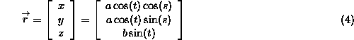
Where t is the geocentirc latitude and s is the longitude.