Rivs: _
26o13'24.3"S 28o06'22.2"E
(-26.223404, 28.106171)
Map 2628AA
377m wide x 405m high
Cape Datum.
Surveys and Mapping.
Data from file
/iwqs3/tmp/dams/tmp/wla500-geo
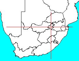
| Rosherville (reservoir) | ||
|---|---|---|
|
|
|
|
|
Rosherville Rivs: _ |
||
|
Locality: 26o13'24.3"S 28o06'22.2"E (-26.223404, 28.106171) Map 2628AA 377m wide x 405m high Cape Datum. |
||
|
Surveys and Mapping. Data from file /iwqs3/tmp/dams/tmp/wla500-geo |
||
| <--Previous | Home^ | Next--> | |
| Resource Quality Services | stmaphtml.aml 2004-05-21 - 12:58:42 | |