| № |
Site
[
view Limpopo sites in Google Earth
]
|
Plot all data |
Date |
MPN, or cfu / 100mL
|
Turb.
NTU |
pH |
Temp.
oC |
Risk based on E. coli if recorded, otherwise on faecal coliforms |
| E. coli |
faecal coliforms |
drinking-
no treatment |
drinking-
limited treatment |
full or
partial
contact |
irrigation-
crops eaten raw |
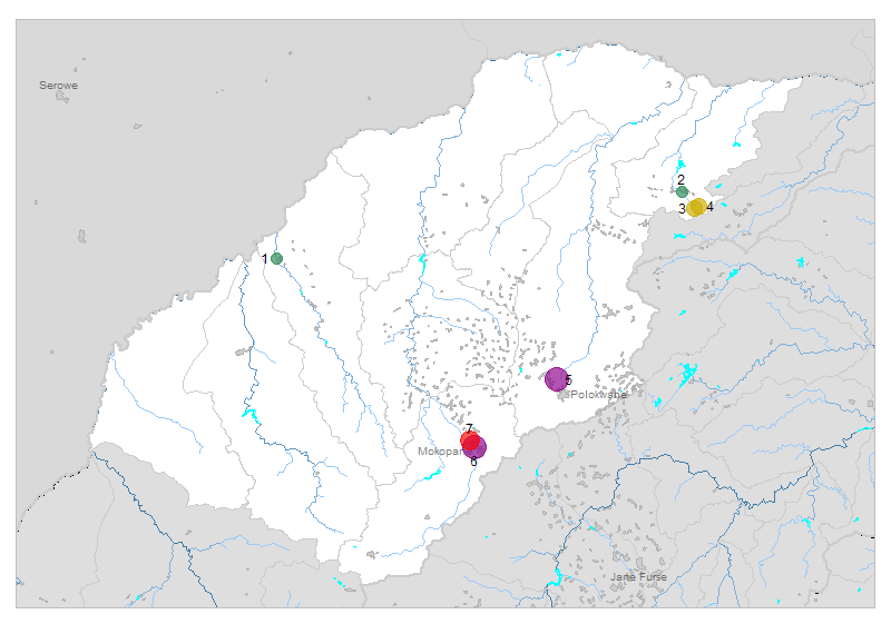
| 1 | 90341 [2-month plot]
Ga-Seleka Village Bossche Diesch 53 LQ R572 Bridge on Lephalala River |

|
2009-12-08 |
52 |
260 |
- |
7.7 |
- |
HIGH |
low |
low |
low |
| 2 | 188510 [2-month plot]
Ha-Rabali at Dzanani to Rabali Road Bridge on Nzhelele |

|
2009-12-08 |
266 |
380 |
9 |
8.0 |
- |
HIGH |
low |
Med |
low |
| 3 | 188512 [2-month plot]
Cordon 218 MT - Tshitavha at Tshedza Tshitavha Bridge on Tshikhwikhwikhwi |

|
2009-12-08 |
1000 |
1000 |
3 |
7.5 |
- |
HIGH |
low |
HIGH |
Med |
| 4 | 188514 [2-month plot]
Tshitavha Colerbre 217 MT - at Bridge from Tshitavha to Phadzima on Tshiluvhadi |

|
2009-12-08 |
1280 |
1600 |
6 |
7.4 |
- |
HIGH |
low |
HIGH |
Med |
| 5 | 190178 [2-month plot]
New Pietersburg Pilgrimshoop 630 LS Dendron R521 Road Bridge on Bloedrivier |

|
2009-12-09 |
54000 |
54000 |
2 |
7.8 |
- |
HIGH |
HIGH |
HIGH |
HIGH |
| 6 | 1000004230 [2-month plot]
Macalacaskop 243 KR R33 Bridge downstream of Sekgakgapeng Oxidation Ponds on Dorpsrivier |

|
2009-12-08 |
280000 |
- |
- |
7.4 |
- |
HIGH |
HIGH |
HIGH |
HIGH |
| 7 | 1000004237 [2-month plot]
Lekalakala Township Macalacaskop 243 KR downstream of Masehlaleng Oxidation Ponds on Rooisloot Rive |

|
2009-12-09 |
9000 |
10000 |
19 |
7.8 |
- |
HIGH |
Med |
HIGH |
HIGH |
| 7 | 1000004237 | |
2009-12-09 |
9000 |
10000 |
19 |
7.8 |
- |
HIGH |
Med |
HIGH |
HIGH |
| 7 | 1000004237 | |
2009-12-09 |
9000 |
10000 |
19 |
7.8 |
- |
HIGH |
Med |
HIGH |
HIGH |
| 7 | 1000004237 | |
2009-12-09 |
9000 |
10000 |
19 |
7.8 |
- |
HIGH |
Med |
HIGH |
HIGH |


