| № |
Site
[
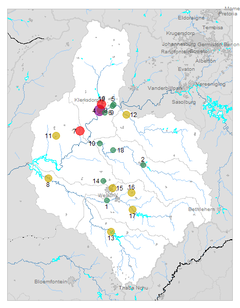
view Middle Vaal sites in Google Earth
]
|
Plot all data |
Date |
MPN, or cfu / 100mL
|
Turb.
NTU |
pH |
Temp.
oC |
Risk based on E. coli if recorded, otherwise on faecal coliforms |
| E. coli |
faecal coliforms |
drinking-
no treatment |
drinking-
limited treatment |
full or
partial
contact |
irrigation-
crops eaten raw |
| 1 | 90800 [2-month plot]
Bloudrif - at R30 Road Bridge on Sand River near Mouth of Doornrivier |

|
2016-04-01 |
262 |
- |
7 |
8.1 |
- |
HIGH |
low |
Med |
low |
| 1 | 90800 | |
2016-04-20 |
64 |
- |
5 |
8.3 |
- |
HIGH |
low |
low |
low |
| 2 | 90849 [2-month plot]
Kroonstad - at R76 Road Bridge on Vals River (Old Barend Wessel) |

|
2016-03-24 |
157 |
- |
11 |
7.8 |
- |
HIGH |
low |
low |
low |
| 2 | 90849 | |
2016-04-26 |
156 |
- |
72 |
7.8 |
- |
HIGH |
low |
low |
low |
| 3 | 182718 [2-month plot]
Skoonspruit D/S from Orkney Sewage Works |

|
2016-03-09 |
9700 |
- |
80 |
7.4 |
- |
HIGH |
Med |
HIGH |
HIGH |
| 3 | 182718 | |
2016-03-22 |
29 |
- |
27 |
8.7 |
- |
HIGH |
low |
low |
low |
| 3 | 182718 | |
2016-04-04 |
2790 |
- |
57 |
8.1 |
- |
HIGH |
Med |
HIGH |
Med |
| 3 | 182718 | |
2016-04-18 |
310 |
- |
9 |
7.5 |
- |
HIGH |
low |
Med |
low |
| 4 | 188130 [2-month plot]
Goedgenoeg 433 IP at Orkney Road Bridge on Jagspruit on R502 |

|
2016-03-09 |
36900 |
- |
14 |
7.4 |
- |
HIGH |
HIGH |
HIGH |
HIGH |
| 4 | 188130 | |
2016-03-22 |
21420 |
- |
9 |
7.5 |
- |
HIGH |
HIGH |
HIGH |
HIGH |
| 4 | 188130 | |
2016-04-04 |
15531 |
- |
7 |
7.4 |
- |
HIGH |
Med |
HIGH |
HIGH |
| 4 | 188130 | |
2016-04-18 |
241960 |
- |
3 |
7.3 |
- |
HIGH |
HIGH |
HIGH |
HIGH |
| 5 | 188131 [2-month plot]
Koekemoerspruit at Buffelsfontein Bridge |

|
2016-03-09 |
2880 |
- |
2 |
7.5 |
- |
HIGH |
Med |
HIGH |
Med |
| 5 | 188131 | |
2016-03-22 |
196 |
- |
2 |
7.6 |
- |
HIGH |
low |
low |
low |
| 5 | 188131 | |
2016-04-04 |
238 |
- |
7 |
7.6 |
- |
HIGH |
low |
Med |
low |
| 5 | 188131 | |
2016-04-18 |
80 |
- |
2 |
7.6 |
- |
HIGH |
low |
low |
low |
| 6 | 188132 [2-month plot]
Orkney - at R30 Bothaville Orkney Bridge on Vaalrivier |

|
2016-03-09 |
166 |
- |
19 |
8.4 |
- |
HIGH |
low |
low |
low |
| 6 | 188132 | |
2016-03-22 |
6910 |
- |
12 |
7.9 |
- |
HIGH |
Med |
HIGH |
HIGH |
| 6 | 188132 | |
2016-04-04 |
16 |
- |
10 |
8.9 |
- |
HIGH |
low |
low |
low |
| 6 | 188132 | |
2016-04-18 |
15 |
- |
10 |
8.7 |
- |
HIGH |
low |
low |
low |
| 7 | 189656 [2-month plot]
Syfergat 56 HP at R504 Leeudoringstad Bothaville Road Bridge on Klipspruit |

|
2016-03-29 |
12098 |
- |
52 |
8.2 |
- |
HIGH |
Med |
HIGH |
HIGH |
| 7 | 189656 | |
2016-04-25 |
24196 |
- |
535 |
8.3 |
- |
HIGH |
HIGH |
HIGH |
HIGH |
| 8 | 191050 [2-month plot]
Floorsdrift 15 - Hoopstad at R59 Road Bridge on Vetrivier |

|
2016-04-01 |
504 |
- |
89 |
7.9 |
- |
HIGH |
low |
HIGH |
low |
| 8 | 191050 | |
2016-04-26 |
830 |
- |
161 |
7.6 |
- |
HIGH |
low |
HIGH |
low |
| 9 | 192624 [2-month plot]
Buffelsfontein 443 IP - at Midvaal Intake |

|
2016-03-09 |
40 |
- |
12 |
8.4 |
- |
HIGH |
low |
low |
low |
| 9 | 192624 | |
2016-03-22 |
65 |
- |
14 |
8.0 |
- |
HIGH |
low |
low |
low |
| 9 | 192624 | |
2016-04-04 |
21 |
- |
10 |
8.9 |
- |
HIGH |
low |
low |
low |
| 9 | 192624 | |
2016-04-18 |
10 |
- |
8 |
8.8 |
- |
HIGH |
low |
low |
low |
| 10 | 194792 [2-month plot]
Bothaville - at R59 Road Bridge Over Vals Rivier |

|
2016-03-24 |
128 |
- |
8 |
7.9 |
- |
HIGH |
low |
low |
low |
| 10 | 194792 | |
2016-04-20 |
71 |
- |
13 |
8.1 |
- |
HIGH |
low |
low |
low |
| 11 | 194793 [2-month plot]
Makwassie - at R502 Road Bridge Over Makwassie Spruit |

|
2016-03-29 |
758 |
- |
4 |
8.2 |
- |
HIGH |
low |
HIGH |
low |
| 11 | 194793 | |
2016-04-25 |
2442 |
- |
14 |
8.0 |
- |
HIGH |
Med |
HIGH |
Med |
| 12 | 194794 [2-month plot]
Rietfontein 299 - at R501 Road Bridge Over Renoster River |

|
2016-03-24 |
3434 |
- |
288 |
7.7 |
- |
HIGH |
Med |
HIGH |
Med |
| 12 | 194794 | |
2016-04-26 |
160 |
- |
8 |
8.0 |
- |
HIGH |
low |
low |
low |
| 13 | 194795 [2-month plot]
Corannakraal 87 - at Road Bridge Over Vet Rivier D/S of Erfenis Dam Wall |

|
2016-04-01 |
733 |
- |
97 |
8.2 |
- |
HIGH |
low |
HIGH |
low |
| 13 | 194795 | |
2016-04-26 |
582 |
- |
134 |
8.0 |
- |
HIGH |
low |
HIGH |
low |
| 14 | 194799 [2-month plot]
Odendaalsrus - at Water Channel (Drain) in Odendaalsrus |

|
2016-04-20 |
57 |
- |
5 |
8.5 |
- |
HIGH |
low |
low |
low |
| 15 | 194801 [2-month plot]
Welkom Thabong Township - at Water Channel in Thabong Township |

|
2016-03-24 |
1362 |
- |
7 |
7.7 |
- |
HIGH |
low |
HIGH |
Med |
| 15 | 194801 | |
2016-04-20 |
1049 |
- |
229 |
7.8 |
- |
HIGH |
low |
HIGH |
Med |
| 16 | 194803 [2-month plot]
Henneman Phomolong Township - at Water Channel in Phomolong Township |

|
2016-03-24 |
1937 |
- |
21 |
7.7 |
- |
HIGH |
low |
HIGH |
Med |
| 17 | 194804 [2-month plot]
Zandrivierspoort 213 - at Road Bridge Over Sand River |

|
2016-04-01 |
175 |
- |
32 |
8.1 |
- |
HIGH |
low |
low |
low |
| 17 | 194804 | |
2016-04-26 |
651 |
- |
24 |
7.9 |
- |
HIGH |
low |
HIGH |
low |
| 18 | 194805 [2-month plot]
Proklameersdrift - at Road Bridge on Vals Rivier |

|
2016-04-01 |
548 |
- |
18 |
8.1 |
- |
HIGH |
low |
HIGH |
low |
| 18 | 194805 | |
2016-04-20 |
79 |
- |
9 |
8.4 |
- |
HIGH |
low |
low |
low |
| 19 | 195409 [2-month plot]
Klerksdorp - at Klerksdorp Correctional Service on Skoonspruit |

|
2016-03-29 |
2420 |
- |
34 |
8.2 |
- |
HIGH |
Med |
HIGH |
Med |
| 19 | 195409 | |
2016-04-25 |
13740 |
- |
34 |
7.8 |
- |
HIGH |
Med |
HIGH |
HIGH |


