| № |
Site
[
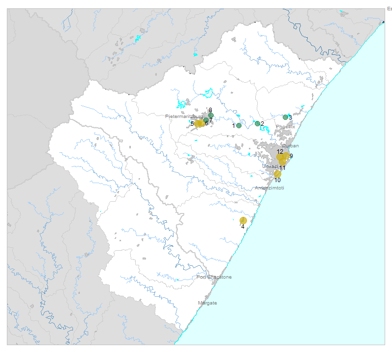
view Mvoti to Umzimkulu sites in Google Earth
]
|
Plot all data |
Date |
MPN, or cfu / 100mL
|
Turb.
NTU |
pH |
Temp.
oC |
Risk based on E. coli if recorded, otherwise on faecal coliforms |
| E. coli |
faecal coliforms |
drinking-
no treatment |
drinking-
limited treatment |
full or
partial
contact |
irrigation-
crops eaten raw |
| 1 | 102632 [2-month plot]
Msunduze River at Inanda/Nomfihlelo |

|
2011-11-01 |
0 |
69100 |
8 |
7.3 |
- |
low |
low |
low |
low |
| 1 | 102632 | |
2011-11-24 |
72 |
242000 |
- |
- |
- |
HIGH |
low |
low |
low |
| 1 | 102632 | |
2011-12-08 |
196 |
24100 |
- |
- |
- |
HIGH |
low |
low |
low |
| 2 | 102662 [2-month plot]
Mgeni River at Inanda/Mumbundwini up/S Inanda Dam |

|
2011-11-01 |
0 |
25100 |
4 |
7.2 |
- |
low |
low |
low |
low |
| 2 | 102662 | |
2011-11-25 |
28 |
242000 |
- |
- |
- |
HIGH |
low |
low |
low |
| 2 | 102662 | |
2011-12-09 |
28 |
101100 |
- |
- |
- |
HIGH |
low |
low |
low |
| 3 | 102674 [2-month plot]
Mdloti River at Roodekrans/Hazelmere Dam Inflow (Roodekrans) |

|
2011-11-01 |
0 |
55000 |
6 |
7.3 |
- |
low |
low |
low |
low |
| 3 | 102674 | |
2011-11-25 |
2420 |
242000 |
- |
- |
- |
HIGH |
Med |
HIGH |
Med |
| 3 | 102674 | |
2011-12-08 |
218 |
53400 |
- |
- |
- |
HIGH |
low |
Med |
low |
| 4 | 187958 [2-month plot]
Umzinto EJ Smith Inflow on Mzimayi |

|
2011-11-01 |
264 |
42500 |
3 |
7.2 |
- |
HIGH |
low |
Med |
low |
| 4 | 187958 | |
2011-11-29 |
2420 |
242000 |
- |
- |
- |
HIGH |
Med |
HIGH |
Med |
| 4 | 187958 | |
2011-12-08 |
1733 |
242000 |
- |
- |
- |
HIGH |
low |
HIGH |
Med |
| 5 | 187959 [2-month plot]
Caluza at Bridge on Msunduze |

|
2011-11-01 |
2420 |
242000 |
9 |
7.5 |
- |
HIGH |
Med |
HIGH |
Med |
| 5 | 187959 | |
2011-11-24 |
1733 |
242000 |
- |
- |
- |
HIGH |
low |
HIGH |
Med |
| 5 | 187959 | |
2011-12-08 |
208 |
20800 |
- |
- |
- |
HIGH |
low |
Med |
low |
| 6 | 187960 [2-month plot]
Edendale downstream of Kwapata on Msunduze |

|
2011-11-01 |
0 |
14700 |
7 |
7.3 |
- |
low |
low |
low |
low |
| 6 | 187960 | |
2011-11-24 |
2420 |
242000 |
- |
- |
- |
HIGH |
Med |
HIGH |
Med |
| 6 | 187960 | |
2011-12-08 |
870 |
101100 |
- |
- |
- |
HIGH |
low |
HIGH |
low |
| 7 | 187961 [2-month plot]
Camp S Drift on Msunduze |

|
2011-11-01 |
0 |
19600 |
11 |
7.4 |
- |
low |
low |
low |
low |
| 7 | 187961 | |
2011-11-24 |
120 |
242000 |
- |
- |
- |
HIGH |
low |
low |
low |
| 7 | 187961 | |
2011-12-08 |
124 |
36200 |
- |
- |
- |
HIGH |
low |
low |
low |
| 8 | 187963 [2-month plot]
Pietermaritzburg Sobantu on Bayne S Spruit |

|
2011-11-01 |
0 |
13600 |
2 |
7.1 |
- |
low |
low |
low |
low |
| 8 | 187963 | |
2011-11-24 |
92 |
242000 |
- |
- |
- |
HIGH |
low |
low |
low |
| 8 | 187963 | |
2011-12-08 |
403 |
96100 |
- |
- |
- |
HIGH |
low |
HIGH |
low |
| 9 | 189144 [2-month plot]
Bulwer Before Entrance to la Habour on Mullet Canal |

|
2011-11-01 |
0 |
66500 |
2 |
7.3 |
- |
low |
low |
low |
low |
| 9 | 189144 | |
2011-11-25 |
2420 |
242000 |
- |
- |
- |
HIGH |
Med |
HIGH |
Med |
| 9 | 189144 | |
2011-12-08 |
437 |
43700 |
- |
- |
- |
HIGH |
low |
HIGH |
low |
| 10 | 189146 [2-month plot]
Isipingo at Isipingo Beach on Isipingo Lagoon |

|
2011-11-01 |
2420 |
242000 |
2 |
7.5 |
- |
HIGH |
Med |
HIGH |
Med |
| 10 | 189146 | |
2011-11-25 |
2420 |
242000 |
- |
- |
- |
HIGH |
Med |
HIGH |
Med |
| 10 | 189146 | |
2011-12-08 |
260 |
54900 |
- |
- |
- |
HIGH |
low |
Med |
low |
| 11 | 189150 [2-month plot]
Clairwood Durban D/S M4 at Start of Mhlathuzana Canal on Mhlathuzana |

|
2011-11-01 |
137 |
59400 |
3 |
7.5 |
- |
HIGH |
low |
low |
low |
| 11 | 189150 | |
2011-11-25 |
961 |
242000 |
- |
- |
- |
HIGH |
low |
HIGH |
low |
| 11 | 189150 | |
2011-12-08 |
770 |
141400 |
- |
- |
- |
HIGH |
low |
HIGH |
low |
| 12 | 189152 [2-month plot]
Umkumbaan U/S of Confluence of Umbilo on Mkhumbane |

|
2011-11-01 |
0 |
91400 |
1 |
7.2 |
- |
low |
low |
low |
low |
| 12 | 189152 | |
2011-11-25 |
2420 |
242000 |
- |
- |
- |
HIGH |
Med |
HIGH |
Med |
| 12 | 189152 | |
2011-12-08 |
1300 |
243000 |
- |
- |
- |
HIGH |
low |
HIGH |
Med |


