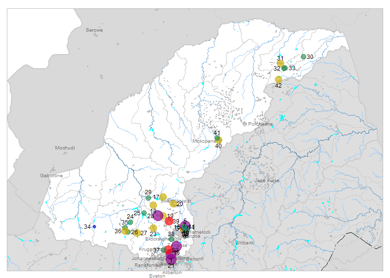
| № |
Site
[
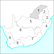
view Limpopo sites in Google Earth
]
|
Plot all data |
Date |
MPN, or cfu / 100mL
|
Turb.
NTU |
pH |
Temp.
oC |
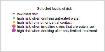
Risk based on E. coli if recorded, otherwise on faecal coliforms |
| E. coli |
faecal coliforms |
drinking-
no treatment |
drinking-
limited treatment |
full or
partial
contact |
irrigation-
crops eaten raw |
| 1 | 88648 [2-month plot]
Jukskei River U/S Confluence Modderfontein Marlboro |

|
2009-09-03 |
130000 |
- |
- |
- |
- |
HIGH |
HIGH |
HIGH |
HIGH |
| 1 | 88648 | |
2009-09-16 |
170000 |
- |
- |
- |
- |
HIGH |
HIGH |
HIGH |
HIGH |
| 1 | 88648 | |
2009-10-22 |
240000 |
- |
- |
- |
- |
HIGH |
HIGH |
HIGH |
HIGH |
| 2 | 90174 [2-month plot]
Pienaars River at Baviaanspoort |

|
2009-10-19 |
8500 |
8500 |
- |
6.5 |
- |
HIGH |
Med |
HIGH |
HIGH |
| 3 | 90175 [2-month plot]
At Kameeldrift on Hartbeesspruit |

|
2009-10-19 |
770 |
770 |
- |
7.6 |
- |
HIGH |
low |
HIGH |
low |
| 4 | 90176 [2-month plot]
At Leeuwfontein on Edendalspruit |

|
2009-10-19 |
108 |
120 |
- |
8.2 |
- |
HIGH |
low |
low |
low |
| 5 | 90234 [2-month plot]
Roodeplaat Sewage: Settling Pond S Outflow |

|
2009-10-19 |
690000 |
690000 |
- |
7.3 |
- |
HIGH |
HIGH |
HIGH |
HIGH |
| 6 | 90236 [2-month plot]
Zeekoegat Sewage Effluent |

|
2009-10-19 |
67 |
67 |
- |
7.7 |
- |
HIGH |
low |
low |
low |
| 7 | 90237 [2-month plot]
Baviaanspoort Sewage Effluent |

|
2009-10-19 |
28 |
28 |
- |
7.0 |
- |
HIGH |
low |
low |
low |
| 8 | 90238 [2-month plot]
At Franspoort Road Bridge on Edendalspruit |

|
2009-10-19 |
320 |
400 |
- |
8.2 |
- |
HIGH |
low |
Med |
low |
| 9 | 90239 [2-month plot]
Pienaars River at Baviaanspoort (Magaliesberg) |

|
2009-10-19 |
110 |
220 |
- |
8.3 |
- |
HIGH |
low |
low |
low |
| 10 | 90275 [2-month plot]
Roodeplaat Dam on Pienaars River: near Dam Wall |

|
2009-10-19 |
5 |
5 |
- |
8.5 |
14.3 |
Med |
low |
low |
low |
| 11 | 90276 [2-month plot]
Roodeplaat Dam on Pienaars River: Point in Dam |

|
2009-10-19 |
2 |
2 |
- |
8.3 |
21.7 |
Med |
low |
low |
low |
| 12 | 90281 [2-month plot]
Roodeplaat Dam on Pienaars River: Point in Dam |

|
2009-10-19 |
10 |
11 |
- |
8.3 |
23.2 |
Med |
low |
low |
low |
| 13 | 90282 [2-month plot]
Roodeplaat Dam on Pienaars River: Point in Dam |

|
2009-10-19 |
0 |
0 |
- |
8.5 |
21.2 |
low |
low |
low |
low |
| 14 | 90283 [2-month plot]
Roodeplaat Dam on Pienaars River: Point in Dam |

|
2009-10-19 |
168 |
168 |
- |
7.9 |
13.7 |
HIGH |
low |
low |
low |
| 15 | 90284 [2-month plot]
Roodeplaat Dam on Pienaars River: Point in Dam |

|
2009-10-19 |
23 |
116 |
- |
- |
- |
HIGH |
low |
low |
low |
| 16 | 100895 [2-month plot]
Kaalspruit 60M D/S of Olifantsfontein - Midrand Old Tar Road |

|
2009-09-02 |
490000 |
490000 |
10 |
7.4 |
- |
HIGH |
HIGH |
HIGH |
HIGH |
| 16 | 100895 | |
2009-09-22 |
1200000 |
1700000 |
26 |
7.2 |
- |
HIGH |
HIGH |
HIGH |
HIGH |
| 16 | 100895 | |
2009-10-08 |
2500000 |
2500000 |
15 |
7.5 |
- |
HIGH |
HIGH |
HIGH |
HIGH |
| 16 | 100895 | |
2009-10-27 |
2200000 |
2600000 |
16 |
7.3 |
- |
HIGH |
HIGH |
HIGH |
HIGH |
| 17 | 179682 [2-month plot]
Moretele River at Sutelong/Rt Tarrbridge |

|
2009-10-13 |
1262 |
- |
31 |
6.2 |
25.2 |
HIGH |
low |
HIGH |
Med |
| 17 | 179682 | |
2009-10-20 |
682 |
- |
129 |
4.8 |
24.3 |
HIGH |
low |
HIGH |
low |
| 17 | 179682 | |
2009-10-28 |
374 |
- |
94 |
9.7 |
25.3 |
HIGH |
low |
Med |
low |
| 18 | 179683 [2-month plot]
Tolwane River at Legonyane 5M U/S Bridge |

|
2009-10-06 |
19863 |
- |
40 |
5.7 |
20.9 |
HIGH |
Med |
HIGH |
HIGH |
| 18 | 179683 | |
2009-10-13 |
1424 |
- |
58 |
5.9 |
23.0 |
HIGH |
low |
HIGH |
Med |
| 18 | 179683 | |
2009-10-20 |
1226 |
- |
10 |
4.9 |
21.7 |
HIGH |
low |
HIGH |
Med |
| 18 | 179683 | |
2009-10-28 |
1076 |
- |
4 |
10.2 |
23.4 |
HIGH |
low |
HIGH |
Med |
| 19 | 179684 [2-month plot]
Sand River at Madidi/50M D/S Left of River |

|
2009-10-06 |
198630 |
- |
0 |
5.2 |
23.6 |
HIGH |
HIGH |
HIGH |
HIGH |
| 19 | 179684 | |
2009-10-13 |
2152 |
- |
17 |
5.6 |
23.7 |
HIGH |
Med |
HIGH |
Med |
| 19 | 179684 | |
2009-10-20 |
126 |
- |
5 |
4.8 |
22.1 |
HIGH |
low |
low |
low |
| 19 | 179684 | |
2009-10-28 |
168 |
- |
2 |
9.4 |
24.6 |
HIGH |
low |
low |
low |
| 20 | 180555 [2-month plot]
Apies at Makapanstad -Swartdamstad/Hammanskraal Rd |

|
2009-10-13 |
1918 |
- |
17 |
6.2 |
25.6 |
HIGH |
low |
HIGH |
Med |
| 20 | 180555 | |
2009-10-28 |
1672 |
- |
4 |
10.1 |
27.0 |
HIGH |
low |
HIGH |
Med |
| 21 | 185640 [2-month plot]
On Jukskei River 150 M D/S of Bruma Lake |

|
2009-09-03 |
2400000 |
- |
- |
- |
- |
HIGH |
HIGH |
HIGH |
HIGH |
| 21 | 185640 | |
2009-09-16 |
96000 |
- |
- |
- |
- |
HIGH |
HIGH |
HIGH |
HIGH |
| 22 | 185688 [2-month plot]
Jukskei River U/S of Confluence with Klein Jukskei Braamfontein Spruit |

|
2009-09-03 |
9300 |
- |
- |
- |
- |
HIGH |
Med |
HIGH |
HIGH |
| 22 | 185688 | |
2009-09-16 |
5600 |
- |
- |
- |
- |
HIGH |
Med |
HIGH |
HIGH |
| 22 | 185688 | |
2009-10-22 |
15000 |
- |
- |
- |
- |
HIGH |
Med |
HIGH |
HIGH |
| 23 | 186797 [2-month plot]
Brits-upstream of R511 Road Bridge-Right Bank |

|
2009-10-20 |
1008 |
- |
0 |
- |
- |
HIGH |
low |
HIGH |
Med |
| 24 | 186798 [2-month plot]
Hex River at First Bridge D/S of Bospoort Dam-Right Bank |

|
2009-10-20 |
104 |
- |
1 |
- |
- |
HIGH |
low |
low |
low |
| 25 | 186800 [2-month plot]
Tshukutswe River-East Bakwena Tribal Authority at Old Bridge |

|
2009-10-19 |
62 |
- |
219 |
- |
- |
HIGH |
low |
low |
low |
| 26 | 186802 [2-month plot]
Kroondal Village Rivierfontein-near Rustenburg Road Bridge |

|
2009-10-20 |
320 |
- |
0 |
- |
- |
HIGH |
low |
Med |
low |
| 27 | 187088 [2-month plot]
At Spuitfontein Road Bridge on Sterkstroom |

|
2009-10-20 |
1666 |
- |
4 |
- |
- |
HIGH |
low |
HIGH |
Med |
| 28 | 187089 [2-month plot]
At Maboloka downstream of Sewage Works on Phuleng River |

|
2009-10-19 |
22398 |
- |
0 |
- |
- |
HIGH |
HIGH |
HIGH |
HIGH |
| 29 | 187095 [2-month plot]
Near the Bridge at Ga Rasai on Moretele |

|
2009-10-19 |
196 |
- |
0 |
- |
- |
HIGH |
low |
low |
low |
| 30 | 188507 [2-month plot]
Tshandama Tengwe S 255 MT Bridge 2 km to Tshandama Tribal Office near Studam on Mutale River |

|
2009-09-29 |
110 |
110 |
1 |
7.4 |
- |
HIGH |
low |
low |
low |
| 31 | 188510 [2-month plot]
Ha-Rabali at Dzanani to Rabali Road Bridge on Nzhelele |

|
2009-09-29 |
480 |
480 |
2 |
8.2 |
- |
HIGH |
low |
HIGH |
low |
| 32 | 188512 [2-month plot]
Cordon 218 MT - Tshitavha at Tshedza Tshitavha Bridge on Tshikhwikhwikhwi |

|
2009-09-29 |
140 |
140 |
1 |
7.4 |
- |
HIGH |
low |
low |
low |
| 33 | 188514 [2-month plot]
Tshitavha Colerbre 217 MT - at Bridge from Tshitavha to Phadzima on Tshiluvhadi |

|
2009-09-29 |
145 |
290 |
6 |
7.4 |
- |
HIGH |
low |
low |
low |
| 34 | 189635 [2-month plot]
Brakfontein 404 JP Borolelo Swartruggens - downstream of Swartruggens WWTW on Elandsrivier |

|
2009-10-20 |
0 |
- |
0 |
- |
- |
low |
low |
low |
low |
| 35 | 190398 [2-month plot]
Rustenburg Correctional Services at Correctional Services Dam |

|
2009-10-20 |
40 |
- |
4 |
- |
- |
HIGH |
low |
low |
low |
| 36 | 190401 [2-month plot]
Waterval Suburb of Phuketbrug on Hexrivier Tributary |

|
2009-10-20 |
524 |
- |
24 |
- |
- |
HIGH |
low |
HIGH |
low |
| 37 | 191695 [2-month plot]
- Bloubosrand Bothasfontein 408 JR - at Road Bridge on Klein Jukskeirivier Tributary |

|
2009-09-03 |
100 |
- |
- |
- |
- |
HIGH |
low |
low |
low |
| 37 | 191695 | |
2009-09-16 |
370 |
- |
- |
- |
- |
HIGH |
low |
Med |
low |
| 37 | 191695 | |
2009-10-22 |
10000 |
- |
- |
- |
- |
HIGH |
Med |
HIGH |
HIGH |
| 38 | 100000771 [2-month plot]
Rietspruit 01 at Old Bridge Behind Sutherland Ridge |

|
2009-09-02 |
60 |
68 |
11 |
7.9 |
- |
HIGH |
low |
low |
low |
| 38 | 100000771 | |
2009-09-22 |
80 |
- |
13 |
7.5 |
- |
HIGH |
low |
low |
low |
| 38 | 100000771 | |
2009-10-08 |
3900 |
4300 |
20 |
7.4 |
- |
HIGH |
Med |
HIGH |
Med |
| 38 | 100000771 | |
2009-10-27 |
370 |
410 |
8 |
6.6 |
- |
HIGH |
low |
Med |
low |
| 39 | 100000815 [2-month plot]
Isg 3 Itsoseng Tributary Confluence |

|
2009-10-13 |
22398 |
- |
10 |
- |
- |
HIGH |
HIGH |
HIGH |
HIGH |
| 39 | 100000815 | |
2009-10-21 |
- |
450 |
- |
6.7 |
- |
HIGH |
low |
HIGH |
low |
| 39 | 100000815 | |
2009-10-28 |
5522 |
- |
6 |
- |
- |
HIGH |
Med |
HIGH |
HIGH |
| 40 | 1000004230 [2-month plot]
Macalacaskop 243 KR R33 Bridge downstream of Sekgakgapeng Oxidation Ponds on Dorpsrivier |

|
2009-09-08 |
1300 |
- |
- |
8.2 |
- |
HIGH |
low |
HIGH |
Med |
| 41 | 1000004237 [2-month plot]
Lekalakala Township Macalacaskop 243 KR downstream of Masehlaleng Oxidation Ponds on Rooisloot Rive |

|
2009-09-08 |
16 |
- |
- |
8.8 |
- |
HIGH |
low |
low |
low |
| 41 | 1000004237 | |
2009-09-08 |
16 |
- |
- |
8.8 |
- |
HIGH |
low |
low |
low |
| 42 | 1000005469 [2-month plot]
Mudzwiriti River downstream of Waterval S/W - Check Position |

|
2009-09-08 |
3500 |
3500 |
2 |
8.8 |
- |
HIGH |
Med |
HIGH |
Med |


