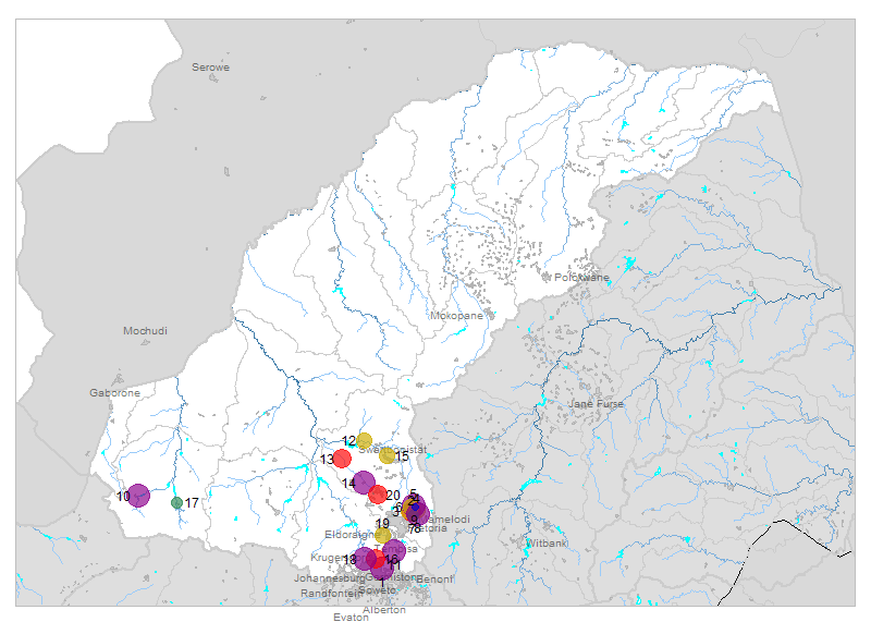
| № |
Site
[
view Limpopo sites in Google Earth
]
|
Plot all data |
Date |
MPN, or cfu / 100mL
|
Turb.
NTU |
pH |
Temp.
oC |
Risk based on E. coli if recorded, otherwise on faecal coliforms |
| E. coli |
faecal coliforms |
drinking-
no treatment |
drinking-
limited treatment |
full or
partial
contact |
irrigation-
crops eaten raw |
| 1 | 88648 [2-month plot]
Jukskei River U/S Confluence Modderfontein Marlboro |

|
2018-05-03 |
890000 |
- |
- |
7.9 |
- |
HIGH |
HIGH |
HIGH |
HIGH |
| 1 | 88648 | |
2018-06-07 |
380000 |
- |
- |
7.4 |
- |
HIGH |
HIGH |
HIGH |
HIGH |
| 2 | 90174 [2-month plot]
Pienaars River at Baviaanspoort |

|
2018-05-07 |
20000 |
20000 |
- |
7.8 |
- |
HIGH |
HIGH |
HIGH |
HIGH |
| 2 | 90174 | |
2018-05-21 |
5800 |
5800 |
- |
8.2 |
- |
HIGH |
Med |
HIGH |
HIGH |
| 2 | 90174 | |
2018-06-04 |
405 |
450 |
- |
7.6 |
- |
HIGH |
low |
HIGH |
low |
| 2 | 90174 | |
2018-06-18 |
740000 |
740000 |
- |
7.5 |
- |
HIGH |
HIGH |
HIGH |
HIGH |
| 3 | 90175 [2-month plot]
At Kameeldrift on Hartbeesspruit |

|
2018-05-07 |
882 |
980 |
- |
8.4 |
- |
HIGH |
low |
HIGH |
low |
| 3 | 90175 | |
2018-05-21 |
5800 |
5800 |
- |
8.5 |
- |
HIGH |
Med |
HIGH |
HIGH |
| 3 | 90175 | |
2018-06-04 |
220 |
220 |
- |
7.8 |
- |
HIGH |
low |
Med |
low |
| 3 | 90175 | |
2018-06-18 |
2600 |
2600 |
- |
8.4 |
- |
HIGH |
Med |
HIGH |
Med |
| 4 | 90176 [2-month plot]
At Leeuwfontein on Edendalspruit |

|
2018-05-07 |
2340 |
2600 |
- |
8.4 |
- |
HIGH |
Med |
HIGH |
Med |
| 4 | 90176 | |
2018-05-21 |
520 |
520 |
- |
- |
- |
HIGH |
low |
HIGH |
low |
| 4 | 90176 | |
2018-06-04 |
44 |
44 |
- |
8.4 |
- |
HIGH |
low |
low |
low |
| 4 | 90176 | |
2018-06-18 |
81500 |
81500 |
- |
8.6 |
- |
HIGH |
HIGH |
HIGH |
HIGH |
| 5 | 90234 [2-month plot]
Roodeplaat Sewage: Settling Pond S Outflow |

|
2018-05-07 |
406000 |
580000 |
- |
7.8 |
- |
HIGH |
HIGH |
HIGH |
HIGH |
| 5 | 90234 | |
2018-05-21 |
24001 |
80000 |
- |
7.4 |
- |
HIGH |
HIGH |
HIGH |
HIGH |
| 5 | 90234 | |
2018-06-04 |
840000 |
840000 |
- |
- |
- |
HIGH |
HIGH |
HIGH |
HIGH |
| 5 | 90234 | |
2018-06-18 |
34000 |
34000 |
- |
7.8 |
- |
HIGH |
HIGH |
HIGH |
HIGH |
| 6 | 90236 [2-month plot]
Zeekoegat Sewage Effluent |

|
2018-05-07 |
7400 |
7400 |
- |
8.1 |
- |
HIGH |
Med |
HIGH |
HIGH |
| 6 | 90236 | |
2018-05-21 |
4400 |
4400 |
- |
8.4 |
- |
HIGH |
Med |
HIGH |
HIGH |
| 6 | 90236 | |
2018-06-04 |
1560 |
1560 |
- |
8.2 |
- |
HIGH |
low |
HIGH |
Med |
| 6 | 90236 | |
2018-06-18 |
22 |
22 |
- |
7.9 |
- |
HIGH |
low |
low |
low |
| 7 | 90237 [2-month plot]
Baviaanspoort Sewage Effluent |

|
2018-05-07 |
150 |
150 |
- |
7.9 |
- |
HIGH |
low |
low |
low |
| 7 | 90237 | |
2018-05-21 |
207 |
230 |
- |
8.2 |
- |
HIGH |
low |
Med |
low |
| 7 | 90237 | |
2018-06-04 |
300 |
300 |
- |
7.8 |
- |
HIGH |
low |
Med |
low |
| 7 | 90237 | |
2018-06-18 |
1680 |
1680 |
- |
8.0 |
- |
HIGH |
low |
HIGH |
Med |
| 8 | 90238 [2-month plot]
At Franspoort Road Bridge on Edendalspruit |

|
2018-05-07 |
79000 |
79000 |
- |
7.7 |
- |
HIGH |
HIGH |
HIGH |
HIGH |
| 8 | 90238 | |
2018-05-21 |
83000 |
83000 |
- |
7.5 |
- |
HIGH |
HIGH |
HIGH |
HIGH |
| 8 | 90238 | |
2018-06-04 |
1840 |
2300 |
- |
7.9 |
- |
HIGH |
low |
HIGH |
Med |
| 8 | 90238 | |
2018-06-18 |
84000 |
84000 |
- |
8.5 |
- |
HIGH |
HIGH |
HIGH |
HIGH |
| 9 | 90275 [2-month plot]
Roodeplaat Dam on Pienaars River: near Dam Wall |

|
2018-05-07 |
16 |
27 |
- |
8.4 |
19.3 |
HIGH |
low |
low |
low |
| 9 | 90275 | |
2018-05-21 |
1 |
4 |
- |
8.5 |
17.0 |
Med |
low |
low |
low |
| 9 | 90275 | |
2018-06-04 |
2 |
2 |
- |
8.1 |
16.1 |
Med |
low |
low |
low |
| 9 | 90275 | |
2018-06-18 |
14 |
14 |
- |
8.4 |
14.6 |
HIGH |
low |
low |
low |
| 10 | 90322 [2-month plot]
Zeerust Hazia 240 JP - at R27 Road Bridge on Kareespruit, D/S of Zeerust WWTW |

|
2018-05-22 |
173290 |
- |
- |
- |
- |
HIGH |
HIGH |
HIGH |
HIGH |
| 10 | 90322 | |
2018-06-05 |
1203300 |
- |
- |
- |
- |
HIGH |
HIGH |
HIGH |
HIGH |
| 11 | 100895 [2-month plot]
Kaalspruit 60M D/S of Olifantsfontein - Midrand Old Tar Road |

|
2018-06-13 |
2419600 |
- |
- |
7.9 |
- |
HIGH |
HIGH |
HIGH |
HIGH |
| 12 | 179682 [2-month plot]
Moretele River at Sutelong/Rt Tarrbridge |

|
2018-05-08 |
560 |
- |
41 |
7.8 |
14.9 |
HIGH |
low |
HIGH |
low |
| 12 | 179682 | |
2018-05-14 |
766 |
- |
22 |
7.4 |
14.7 |
HIGH |
low |
HIGH |
low |
| 12 | 179682 | |
2018-05-22 |
790 |
- |
47 |
7.1 |
16.1 |
HIGH |
low |
HIGH |
low |
| 12 | 179682 | |
2018-05-28 |
313 |
- |
44 |
7.9 |
14.3 |
HIGH |
low |
Med |
low |
| 12 | 179682 | |
2018-06-05 |
409 |
- |
13 |
- |
- |
HIGH |
low |
HIGH |
low |
| 12 | 179682 | |
2018-06-11 |
472 |
- |
10 |
7.8 |
10.4 |
HIGH |
low |
HIGH |
low |
| 12 | 179682 | |
2018-06-19 |
731 |
- |
8 |
8.0 |
11.2 |
HIGH |
low |
HIGH |
low |
| 13 | 179683 [2-month plot]
Tolwane River at Legonyane 5M U/S Bridge |

|
2018-05-08 |
12262 |
- |
11 |
7.8 |
14.1 |
HIGH |
Med |
HIGH |
HIGH |
| 13 | 179683 | |
2018-05-14 |
48392 |
- |
- |
7.4 |
13.9 |
HIGH |
HIGH |
HIGH |
HIGH |
| 13 | 179683 | |
2018-05-22 |
1624 |
- |
5 |
7.6 |
15.4 |
HIGH |
low |
HIGH |
Med |
| 13 | 179683 | |
2018-05-28 |
4028 |
- |
13 |
8.0 |
14.5 |
HIGH |
Med |
HIGH |
HIGH |
| 13 | 179683 | |
2018-06-05 |
10950 |
- |
30 |
- |
- |
HIGH |
Med |
HIGH |
HIGH |
| 13 | 179683 | |
2018-06-11 |
4839 |
- |
8 |
7.9 |
10.8 |
HIGH |
Med |
HIGH |
HIGH |
| 13 | 179683 | |
2018-06-19 |
1637 |
- |
4 |
7.9 |
10.2 |
HIGH |
low |
HIGH |
Med |
| 14 | 179684 [2-month plot]
Sand River at Madidi/50M D/S Left of River |

|
2018-05-08 |
1046200 |
- |
3 |
7.7 |
18.6 |
HIGH |
HIGH |
HIGH |
HIGH |
| 14 | 179684 | |
2018-05-14 |
1553100 |
- |
2 |
7.4 |
15.3 |
HIGH |
HIGH |
HIGH |
HIGH |
| 14 | 179684 | |
2018-05-22 |
980400 |
- |
1 |
8.0 |
19.1 |
HIGH |
HIGH |
HIGH |
HIGH |
| 14 | 179684 | |
2018-05-28 |
241960 |
- |
1 |
7.8 |
18.4 |
HIGH |
HIGH |
HIGH |
HIGH |
| 14 | 179684 | |
2018-06-05 |
26790 |
- |
2 |
- |
- |
HIGH |
HIGH |
HIGH |
HIGH |
| 14 | 179684 | |
2018-06-11 |
26030 |
- |
3 |
7.6 |
14.5 |
HIGH |
HIGH |
HIGH |
HIGH |
| 14 | 179684 | |
2018-06-19 |
198630 |
- |
1 |
8.0 |
15.1 |
HIGH |
HIGH |
HIGH |
HIGH |
| 15 | 180555 [2-month plot]
Apies at Makapanstad -Swartdamstad/Hammanskraal Rd |

|
2018-05-14 |
8704 |
- |
9 |
7.2 |
15.1 |
HIGH |
Med |
HIGH |
HIGH |
| 15 | 180555 | |
2018-05-28 |
1323 |
- |
21 |
7.6 |
14.7 |
HIGH |
low |
HIGH |
Med |
| 15 | 180555 | |
2018-06-11 |
3106 |
- |
12 |
7.6 |
11.0 |
HIGH |
Med |
HIGH |
Med |
| 16 | 185688 [2-month plot]
Jukskei River U/S of Confluence with Klein Jukskei Braamfontein Spruit |

|
2018-05-03 |
27000 |
- |
- |
7.8 |
- |
HIGH |
HIGH |
HIGH |
HIGH |
| 16 | 185688 | |
2018-06-07 |
8200 |
- |
- |
7.6 |
- |
HIGH |
Med |
HIGH |
HIGH |
| 17 | 188261 [2-month plot]
A3GMAR Groot- Marico Wonderfontein 258 JP - at N4 Road Bridge on Groot Marico Rivier |

|
2018-05-22 |
179 |
- |
- |
- |
- |
HIGH |
low |
low |
low |
| 17 | 188261 | |
2018-06-05 |
108 |
- |
- |
- |
- |
HIGH |
low |
low |
low |
| 18 | 191695 [2-month plot]
- Bloubosrand Bothasfontein 408 JR - at Road Bridge on Klein Jukskeirivier Tributary |

|
2018-05-03 |
1700000 |
- |
- |
- |
- |
HIGH |
HIGH |
HIGH |
HIGH |
| 18 | 191695 | |
2018-06-07 |
28000 |
- |
- |
- |
- |
HIGH |
HIGH |
HIGH |
HIGH |
| 19 | 100000771 [2-month plot]
Rietspruit 01 at Old Bridge Behind Sutherland Ridge |

|
2018-06-13 |
3232 |
- |
- |
8.6 |
- |
HIGH |
Med |
HIGH |
Med |
| 20 | 100000815 [2-month plot]
Isg 3 Itsoseng Tributary Confluence |

|
2018-05-14 |
60770 |
- |
23 |
- |
- |
HIGH |
HIGH |
HIGH |
HIGH |
| 20 | 100000815 | |
2018-05-28 |
12262 |
- |
0 |
- |
- |
HIGH |
Med |
HIGH |
HIGH |
| 20 | 100000815 | |
2018-06-11 |
7608 |
129970 |
2 |
- |
- |
HIGH |
Med |
HIGH |
HIGH |


