| № |
Site
[
view Limpopo sites in Google Earth
]
|
Plot all data |
Date |
MPN, or cfu / 100mL
|
Turb.
NTU |
pH |
Temp.
oC |
Risk based on E. coli if recorded, otherwise on faecal coliforms |
| E. coli |
faecal coliforms |
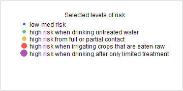
drinking-
no treatment |
drinking-
limited treatment |
full or
partial
contact |
irrigation-
crops eaten raw |
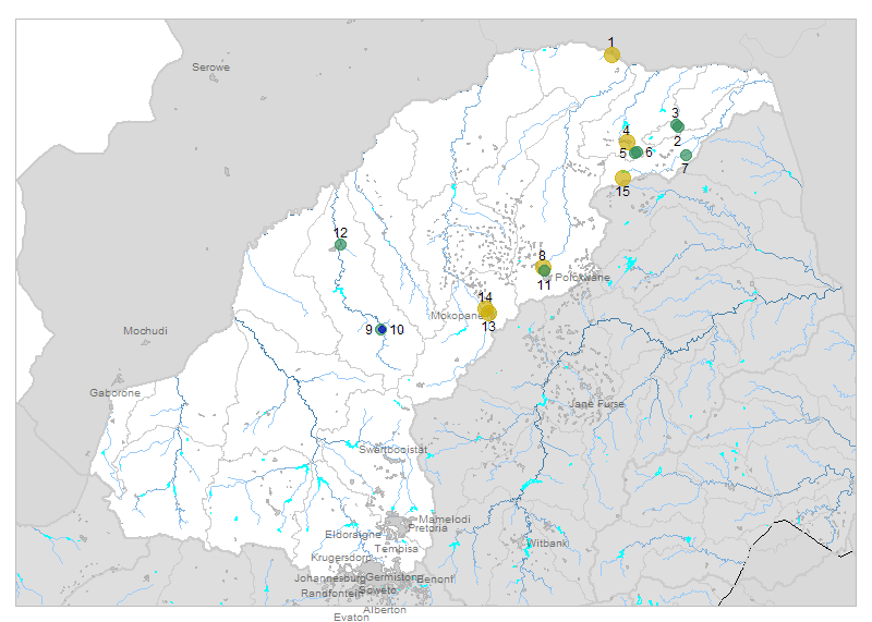
| 1 | 90375 [2-month plot]
Downstream of Beit Bridge on Limpopo River |

|
2019-09-03 |
1553 |
- |
6 |
8.4 |
- |
HIGH |
low |
HIGH |
Med |
| 1 | 90375 | |
2019-10-01 |
28 |
- |
15 |
8.1 |
- |
HIGH |
low |
low |
low |
| 2 | 188507 [2-month plot]
Tshandama Tengwe S 255 MT Bridge 2 km to Tshandama Tribal Office near Studam on Mutale River |

|
2019-09-03 |
121 |
- |
3 |
7.1 |
- |
HIGH |
low |
low |
low |
| 2 | 188507 | |
2019-10-02 |
219 |
- |
5 |
8.1 |
- |
HIGH |
low |
Med |
low |
| 3 | 188509 [2-month plot]
Tshandama Tengwe S 255 MT Bridge near Tshandama Tribal Office on Nyahalwe River |

|
2019-10-02 |
147 |
- |
11 |
7.6 |
- |
HIGH |
low |
low |
low |
| 4 | 188510 [2-month plot]
Ha-Rabali at Dzanani to Rabali Road Bridge on Nzhelele |

|
2019-09-03 |
816 |
- |
6 |
8.0 |
- |
HIGH |
low |
HIGH |
low |
| 4 | 188510 | |
2019-09-03 |
816 |
- |
6 |
8.0 |
- |
HIGH |
low |
HIGH |
low |
| 4 | 188510 | |
2019-10-01 |
2420 |
- |
26 |
8.3 |
- |
HIGH |
Med |
HIGH |
Med |
| 4 | 188510 | |
2019-10-28 |
727 |
- |
7 |
7.7 |
- |
HIGH |
low |
HIGH |
low |
| 5 | 188512 [2-month plot]
Cordon 218 MT - Tshitavha at Tshedza Tshitavha Bridge on Tshikhwikhwikhwi |

|
2019-09-03 |
23 |
- |
7 |
7.5 |
- |
HIGH |
low |
low |
low |
| 5 | 188512 | |
2019-09-30 |
48 |
- |
3 |
8.1 |
- |
HIGH |
low |
low |
low |
| 5 | 188512 | |
2019-10-28 |
63 |
- |
20 |
8.3 |
- |
HIGH |
low |
low |
low |
| 6 | 188514 [2-month plot]
Tshitavha Colerbre 217 MT - at Bridge from Tshitavha to Phadzima on Tshiluvhadi |

|
2019-09-03 |
261 |
- |
4 |
7.7 |
- |
HIGH |
low |
Med |
low |
| 6 | 188514 | |
2019-09-30 |
248 |
- |
9 |
8.0 |
- |
HIGH |
low |
Med |
low |
| 6 | 188514 | |
2019-10-28 |
308 |
- |
4 |
7.7 |
- |
HIGH |
low |
Med |
low |
| 7 | 190136 [2-month plot]
Nandoni Dam downstream of Dam Weir on Luvuvhu River |

|
2019-09-03 |
32 |
- |
4 |
7.9 |
- |
HIGH |
low |
low |
low |
| 7 | 190136 | |
2019-10-01 |
22 |
- |
2 |
7.5 |
- |
HIGH |
low |
low |
low |
| 7 | 190136 | |
2019-10-29 |
517 |
- |
2 |
7.4 |
- |
HIGH |
low |
HIGH |
low |
| 8 | 190178 [2-month plot]
New Pietersburg Pilgrimshoop 630 LS Dendron R521 Road Bridge on Bloedrivier |

|
2019-09-03 |
2420 |
- |
15 |
7.4 |
- |
HIGH |
Med |
HIGH |
Med |
| 8 | 190178 | |
2019-10-28 |
2420 |
- |
6 |
7.3 |
- |
HIGH |
Med |
HIGH |
Med |
| 9 | 190195 [2-month plot]
Vaalwater 137 KR upstream of Vaalwater Ponds 1 km to Sederberg Rest Camp on Mokolo River |

|
2019-09-03 |
19 |
- |
4 |
7.1 |
- |
HIGH |
low |
low |
low |
| 10 | 190211 [2-month plot]
Vaalwater 137 KR D/S Vaalwater Ponds 0.5 km to Sederberg Rest Camp on Mokolo |

|
2019-09-03 |
3 |
- |
5 |
7.0 |
- |
Med |
low |
low |
low |
| 11 | 190253 [2-month plot]
Pilgrimshoop 630 LS U/S of Polokwane WWTW Effluent Discharge on Sandrivier |

|
2019-09-03 |
114 |
- |
28 |
7.6 |
- |
HIGH |
low |
low |
low |
| 11 | 190253 | |
2019-10-02 |
687 |
- |
6 |
8.0 |
- |
HIGH |
low |
HIGH |
low |
| 11 | 190253 | |
2019-10-28 |
345 |
- |
27 |
7.7 |
- |
HIGH |
low |
Med |
low |
| 12 | 190297 [2-month plot]
Ellisras Werkendam 474 LQ R518 Bridge 3KM Before Comfluence on Mokolo River |

|
2019-09-03 |
44 |
- |
4 |
7.2 |
- |
HIGH |
low |
low |
low |
| 12 | 190297 | |
2019-09-30 |
61 |
- |
5 |
7.8 |
- |
HIGH |
low |
low |
low |
| 13 | 1000004230 [2-month plot]
Macalacaskop 243 KR R33 Bridge downstream of Sekgakgapeng Oxidation Ponds on Dorpsrivier |

|
2019-09-03 |
2420 |
- |
88 |
6.5 |
- |
HIGH |
Med |
HIGH |
Med |
| 13 | 1000004230 | |
2019-10-01 |
2420 |
- |
457 |
7.0 |
- |
HIGH |
Med |
HIGH |
Med |
| 14 | 1000004237 [2-month plot]
Lekalakala Township Macalacaskop 243 KR downstream of Masehlaleng Oxidation Ponds on Rooisloot Rive |

|
2019-10-01 |
1046 |
- |
9 |
8.0 |
- |
HIGH |
low |
HIGH |
Med |
| 15 | 1000005469 [2-month plot]
Mudzwiriti River downstream of Waterval S/W - Check Position |

|
2019-09-03 |
488 |
- |
4 |
8.0 |
- |
HIGH |
low |
HIGH |
low |
| 15 | 1000005469 | |
2019-10-01 |
1046 |
- |
2 |
7.0 |
- |
HIGH |
low |
HIGH |
Med |
| 15 | 1000005469 | |
2019-10-29 |
148 |
- |
2 |
7.3 |
- |
HIGH |
low |
low |
low |


