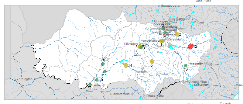
| № |
Site
[
view Vaal sites in Google Earth
]
|
Plot all data |
Date |
MPN, or cfu / 100mL
|
Turb.
NTU |
pH |
Temp.
oC |
Risk based on E. coli if recorded, otherwise on faecal coliforms |
| E. coli |
faecal coliforms |
drinking-
no treatment |
drinking-
limited treatment |
full or
partial
contact |
irrigation-
crops eaten raw |
| 1 | 90616 [2-month plot]
Rietspruit at Kaalplaats (Rw RV2) |

|
2013-09-10 |
3700 |
4600 |
- |
7.6 |
- |
HIGH |
Med |
HIGH |
Med |
| 2 | 90697 [2-month plot]
(B8) Nigel R51 Road Bridge to Balfour |

|
2013-09-17 |
430 |
700 |
- |
8.1 |
- |
HIGH |
low |
HIGH |
low |
| 3 | 90725 [2-month plot]
Klip River at R41 Witpoortjie U/S Durban Deep Mine |

|
2013-09-10 |
59 |
59 |
90 |
7.7 |
- |
HIGH |
low |
low |
low |
| 4 | 90727 [2-month plot]
At Golden Highway Olifantsvlei van Wyk on Kliprivier |

|
2013-09-10 |
63 |
63 |
8 |
8.1 |
- |
HIGH |
low |
low |
low |
| 5 | 90849 [2-month plot]
Kroonstad - at R76 Road Bridge on Vals River (Old Barend Wessel) |

|
2013-09-20 |
2420 |
- |
3 |
7.8 |
- |
HIGH |
Med |
HIGH |
Med |
| 5 | 90849 | |
2013-10-17 |
2420 |
- |
- |
7.8 |
- |
HIGH |
Med |
HIGH |
Med |
| 6 | 101770 [2-month plot]
Smidts Drift Outspan 23 Schmidtsdrift at Weir on Vaal River |

|
2013-09-13 |
29 |
- |
- |
- |
- |
HIGH |
low |
low |
low |
| 6 | 101770 | |
2013-10-18 |
56 |
- |
- |
- |
- |
HIGH |
low |
low |
low |
| 7 | 182718 [2-month plot]
Skoonspruit D/S from Orkney Sewage Works |

|
2013-09-17 |
2420 |
- |
- |
7.8 |
- |
HIGH |
Med |
HIGH |
Med |
| 7 | 182718 | |
2013-10-08 |
2420 |
- |
- |
7.5 |
- |
HIGH |
Med |
HIGH |
Med |
| 8 | 188130 [2-month plot]
Goedgenoeg 433 IP at Orkney Road Bridge on Jagspruit on R502 |

|
2013-09-17 |
1203 |
- |
- |
7.7 |
- |
HIGH |
low |
HIGH |
Med |
| 8 | 188130 | |
2013-10-08 |
2420 |
- |
- |
7.5 |
- |
HIGH |
Med |
HIGH |
Med |
| 9 | 188132 [2-month plot]
Orkney - at R30 Bothaville Orkney Bridge on Vaalrivier |

|
2013-09-13 |
190 |
- |
- |
8.9 |
- |
HIGH |
low |
low |
low |
| 9 | 188132 | |
2013-10-23 |
280 |
- |
- |
8.8 |
- |
HIGH |
low |
Med |
low |
| 10 | 188487 [2-month plot]
Gong Gong D/S Barkly West on Vaal |

|
2013-09-13 |
411 |
- |
- |
- |
- |
HIGH |
low |
HIGH |
low |
| 10 | 188487 | |
2013-10-18 |
5 |
- |
- |
- |
- |
Med |
low |
low |
low |
| 11 | 188489 [2-month plot]
Doornfonteyn Middelplaats D/S Warrenton on Vaal |

|
2013-09-13 |
0 |
- |
- |
- |
- |
low |
low |
low |
low |
| 11 | 188489 | |
2013-10-18 |
225 |
- |
- |
- |
- |
HIGH |
low |
Med |
low |
| 12 | 189142 [2-month plot]
Standerton Sakhile downstream of STW and Bucket Dumping Site on Vaal |

|
2013-09-17 |
20000 |
30000 |
23 |
7.9 |
- |
HIGH |
HIGH |
HIGH |
HIGH |
| 13 | 189147 [2-month plot]
Warden 150 M upstream of Dam Wall on Cornelisrivier |

|
2013-09-04 |
20 |
20 |
6 |
7.9 |
- |
HIGH |
low |
low |
low |
| 14 | 191050 [2-month plot]
Floorsdrift 15 - Hoopstad at R59 Road Bridge on Vetrivier |

|
2013-09-18 |
1986 |
- |
- |
9.4 |
- |
HIGH |
low |
HIGH |
Med |
| 14 | 191050 | |
2013-10-14 |
2420 |
- |
- |
9.3 |
- |
HIGH |
Med |
HIGH |
Med |
| 15 | 192536 [2-month plot]
Pampierstad - at Vaal-Harts Weir on Hartsrivier |

|
2013-09-13 |
85 |
- |
- |
- |
- |
HIGH |
low |
low |
low |
| 15 | 192536 | |
2013-10-18 |
291 |
- |
- |
- |
- |
HIGH |
low |
Med |
low |


