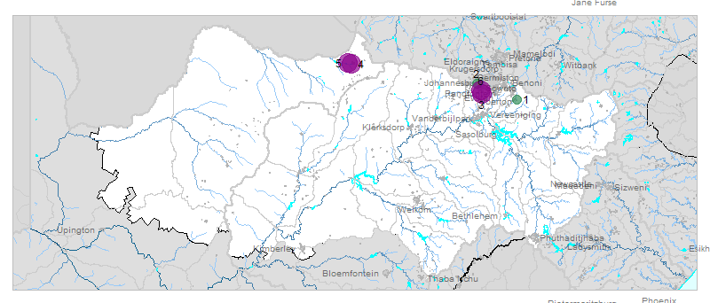
| № |
Site
[
view Vaal sites in Google Earth
]
|
Plot all data |
Date |
MPN, or cfu / 100mL
|
Turb.
NTU |
pH |
Temp.
oC |
Risk based on E. coli if recorded, otherwise on faecal coliforms |
| E. coli |
faecal coliforms |
drinking-
no treatment |
drinking-
limited treatment |
full or
partial
contact |
irrigation-
crops eaten raw |
| 1 | 90616 [2-month plot]
Rietspruit at Kaalplaats (Rw RV2) |

|
2024-07-05 |
185000 |
185000 |
- |
7.0 |
- |
HIGH |
HIGH |
HIGH |
HIGH |
| 1 | 90616 | |
2024-07-30 |
133400 |
133400 |
- |
7.0 |
- |
HIGH |
HIGH |
HIGH |
HIGH |
| 1 | 90616 | |
2024-08-28 |
185000 |
185000 |
- |
7.5 |
- |
HIGH |
HIGH |
HIGH |
HIGH |
| 2 | 90697 [2-month plot]
(B8) Nigel R51 Road Bridge to Balfour |

|
2024-07-02 |
258 |
- |
- |
- |
- |
HIGH |
low |
Med |
low |
| 2 | 90697 | |
2024-07-03 |
309 |
5120 |
- |
7.9 |
- |
HIGH |
low |
Med |
low |
| 2 | 90697 | |
2024-07-16 |
313 |
- |
- |
- |
- |
HIGH |
low |
Med |
low |
| 2 | 90697 | |
2024-08-01 |
282 |
282 |
- |
7.8 |
- |
HIGH |
low |
Med |
low |
| 2 | 90697 | |
2024-08-14 |
262 |
- |
- |
- |
- |
HIGH |
low |
Med |
low |
| 2 | 90697 | |
2024-08-27 |
176 |
- |
- |
- |
- |
HIGH |
low |
low |
low |
| 3 | 90725 [2-month plot]
Klip River at R41 Witpoortjie U/S Durban Deep Mine |

|
2024-07-02 |
5 |
- |
- |
- |
- |
Med |
low |
low |
low |
| 3 | 90725 | |
2024-07-09 |
624 |
624 |
- |
7.3 |
- |
HIGH |
low |
HIGH |
low |
| 3 | 90725 | |
2024-07-16 |
32 |
- |
- |
- |
- |
HIGH |
low |
low |
low |
| 3 | 90725 | |
2024-07-31 |
4106 |
4106 |
- |
7.3 |
- |
HIGH |
Med |
HIGH |
HIGH |
| 3 | 90725 | |
2024-08-14 |
50 |
- |
- |
- |
- |
HIGH |
low |
low |
low |
| 3 | 90725 | |
2024-08-27 |
13500 |
13500 |
- |
7.7 |
- |
HIGH |
Med |
HIGH |
HIGH |
| 3 | 90725 | |
2024-08-27 |
20 |
- |
- |
7.7 |
- |
HIGH |
low |
low |
low |
| 4 | 90727 [2-month plot]
At Golden Highway Olifantsvlei van Wyk on Kliprivier |

|
2024-07-02 |
579400 |
- |
- |
- |
- |
HIGH |
HIGH |
HIGH |
HIGH |
| 4 | 90727 | |
2024-07-09 |
627000 |
5794000 |
- |
7.2 |
- |
HIGH |
HIGH |
HIGH |
HIGH |
| 4 | 90727 | |
2024-07-16 |
579400 |
- |
- |
- |
- |
HIGH |
HIGH |
HIGH |
HIGH |
| 4 | 90727 | |
2024-07-31 |
341000 |
341000 |
- |
7.2 |
- |
HIGH |
HIGH |
HIGH |
HIGH |
| 4 | 90727 | |
2024-08-14 |
1299700 |
- |
- |
- |
- |
HIGH |
HIGH |
HIGH |
HIGH |
| 4 | 90727 | |
2024-08-27 |
1986300 |
- |
- |
7.4 |
- |
HIGH |
HIGH |
HIGH |
HIGH |
| 4 | 90727 | |
2024-08-27 |
160000 |
160000 |
- |
7.4 |
- |
HIGH |
HIGH |
HIGH |
HIGH |
| 5 | 188131 [2-month plot]
Koekemoerspruit at Buffelsfontein Bridge |

|
2024-07-11 |
435 |
- |
2 |
8.0 |
- |
HIGH |
low |
HIGH |
low |
| 5 | 188131 | |
2024-08-14 |
185 |
- |
12 |
8.0 |
- |
HIGH |
low |
low |
low |
| 6 | 188262 [2-month plot]
Mmabatho - at Road Bridge on Molopo River, D/S of Mafikeng |

|
2024-07-01 |
1299650 |
- |
- |
- |
- |
HIGH |
HIGH |
HIGH |
HIGH |
| 6 | 188262 | |
2024-07-15 |
1046200 |
- |
- |
- |
- |
HIGH |
HIGH |
HIGH |
HIGH |
| 6 | 188262 | |
2024-08-13 |
1986300 |
- |
- |
- |
- |
HIGH |
HIGH |
HIGH |
HIGH |
| 6 | 188262 | |
2024-08-26 |
1203300 |
- |
- |
- |
- |
HIGH |
HIGH |
HIGH |
HIGH |
| 7 | 189147 [2-month plot]
Warden 150 M upstream of Dam Wall on Cornelisrivier |

|
2024-07-10 |
1553 |
1553 |
21 |
7.2 |
- |
HIGH |
low |
HIGH |
Med |
| 7 | 189147 | |
2024-08-05 |
461 |
461 |
- |
7.5 |
- |
HIGH |
low |
HIGH |
low |
| 8 | 191688 [2-month plot]
Mmabatho - D/S of Mmabatho WWTW, on Molopo Tributary. |

|
2024-07-01 |
727000 |
- |
- |
- |
- |
HIGH |
HIGH |
HIGH |
HIGH |
| 8 | 191688 | |
2024-07-15 |
2419600 |
- |
- |
- |
- |
HIGH |
HIGH |
HIGH |
HIGH |
| 8 | 191688 | |
2024-08-13 |
2419600 |
- |
- |
- |
- |
HIGH |
HIGH |
HIGH |
HIGH |
| 8 | 191688 | |
2024-08-26 |
1732900 |
- |
- |
- |
- |
HIGH |
HIGH |
HIGH |
HIGH |
| 9 | 191693 [2-month plot]
- Soweto Eldoradopark - at Road Bridge on Klipspruit |

|
2024-07-02 |
120330 |
- |
- |
- |
- |
HIGH |
HIGH |
HIGH |
HIGH |
| 9 | 191693 | |
2024-07-16 |
241960 |
- |
- |
- |
- |
HIGH |
HIGH |
HIGH |
HIGH |
| 9 | 191693 | |
2024-08-14 |
241960 |
- |
- |
- |
- |
HIGH |
HIGH |
HIGH |
HIGH |
| 9 | 191693 | |
2024-08-27 |
285100 |
- |
- |
- |
- |
HIGH |
HIGH |
HIGH |
HIGH |
| 10 | 191696 [2-month plot]
Sia 20 - Eldorado Park Goudkoppie - at Goudkoppie WWTW, near Power Park |

|
2024-07-11 |
230000 |
- |
- |
- |
- |
HIGH |
HIGH |
HIGH |
HIGH |
| 10 | 191696 | |
2024-08-08 |
350000 |
- |
- |
- |
- |
HIGH |
HIGH |
HIGH |
HIGH |
| 11 | 191876 [2-month plot]
Roodepoort Bothasfontein 408 JR - at Florida Lake Outlet |

|
2024-07-24 |
2800 |
- |
- |
7.0 |
21.8 |
HIGH |
Med |
HIGH |
Med |
| 11 | 191876 | |
2024-08-08 |
2400 |
- |
- |
- |
- |
HIGH |
Med |
HIGH |
Med |
| 12 | 192624 [2-month plot]
Buffelsfontein 443 IP - at Midvaal Intake |

|
2024-07-15 |
135 |
- |
12 |
8.8 |
- |
HIGH |
low |
low |
low |
| 12 | 192624 | |
2024-08-15 |
28 |
- |
15 |
9.2 |
- |
HIGH |
low |
low |
low |


