 |
Department of Water Affairs and Forestry |
| Institute for Water Quality Studies |
| Home | Contact us | Last updated : 10 July 2001 |
The water quality of the Roodeplaat Dam is monitored on a regular weekly basis at five sites of which only two (Sites 1 and 7) will be discussed in this report. Site 1 was chosen because it is near the dam wall, at the deepest site in the impoundment and when compared to Site 7 will give a spatial view of water quality change, if any, in the impoundment. Site 7 was chosen because it is the closest regular site to the impacted areas and would give a good background to the historical water quality in this area of the impoundment. The additional ad hoc sites (Sites A and B) were visited twice during the period of a month to determine the cause and extent of the pollution incident.
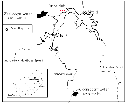
Routine water quality samples were taken with a 5 m hose-pipe at Site 1 and 7 (Figure 1). This method of sampling provides an integrated sample representative of the top 5 meters of the water column. These samples were then poured into separate sampling bottles for macro-chemical analyses and biological sampling analyses. The macro (major inorganic chemical constituent) samples were preserved with HgCl2 and the algal identification samples were preserved in 1 ml Lugol’s solution.
The ad hoc sampling was done by taking grab samples as the sites were too shallow for hose-pipe sampling. These water samples were then poured into the appropriate sampling bottles, preserved and transferred to the laboratories within an hour. As the origin of the pollution incidents was not known samples were collected to do macro-, trace metal and biological analyses. The microbiological samples were taken separately by submersion of the sterilised bottles in the water.
Physical measurements were taken in situ with the exception of pH. The temperature and oxygen readings were taken with a YSI 95 oxygen and temperature meter and the pH reading was determined in the Macro Elements Laboratory at the IWQS.
The Roodeplaat Dam is situated at the confluence of the Pienaars River, the Moreleta/Hartbees Spruit, and the Edendalespruit, 20 km north-east of Pretoria. These rivers drain the highly populated areas of northern and eastern Pretoria. The catchment includes two point sources, namely, a) the Baviaanspoort Water Care Works (WCW) situated on the Pienaars River, and b) the Zeekoegat WCW that discharges directly into the Roodeplaat Dam at the Canoe Club. Diffuse sources include formal and informal settlements, as well as agricultural activities along the banks of the tributaries (Hohls et al. 1998). The impoundment is used extensively for recreational purposes. A recent publication stated that the Roodeplaat Dam is highly eutrophic (Hohls, et al. 1999).
The impoundment is an important recreational resource (fishing, canoeing, and other water related uses) for the greater Gauteng area. The water is, therefore, used for direct contact - and semi-contact recreation.
Routine sampling is done at 5 sites on the Roodeplaat Dam. Only two of the routine sites (Site 1 and 7) will be discussed in this report to show the variation between Sites 1 and 7. Site 1 is at the dam wall and is, therefore, the site at which the water depth is the greater of the two sites. It has a maximum depth of 40 m. Site 7 is a shallow site with a maximum depth of 7 m and is situated at the confluence of the Pienaars River and the Moreleta/Hartbees Spruit on the Roodeplaat Dam. Site 7 is, therefore, comparable to the affected sites.

Figure 1. Sampling sites on the Roodeplaat Dam.