GOVERNMENT GAZETTE, 1 OCTOBER 1999 NO. 20491
Department of Water and Sanitation AND FORESTRY
No. 1160, 1 October 1999
NATIONAL WATER ACT, 1998 (ACT N0. 36 OF 1998)
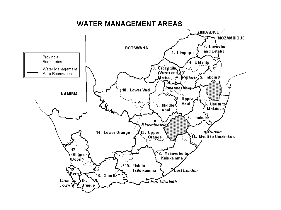
ESTABLISHMENT OF THE WATER MANAGEMENT AREAS AND THEIR BOUNDARIES AS A COMPONENT OF THE NATIONAL WATER RESOURCE STRATEGY IN TERMS OF SECTION 5(1) OF THE NATIONAL WATER ACT (ACT NO. 36 OF 1998)
I, RONALD KASRILS, MP, Minister of Water and Sanitation, hereby in terms of Section 5(1) of the National Water Act, 1998 (Act No. 36 of 1998), establish the water management areas and determine their boundaries as contained in the Schedule hereto as a component of the National Water Resource Strategy.
SCHEDULE
WATER MANAGEMENT AREA |
BOUNDARY DESCRIPTION |
Major rivers include the Limpopo, Matlabas, Mokolo, Lephalala, Mogalakwena, Sand and Nzhelele |
|
Major rivers include the Mutale, Luvuvhu and Letaba |
Tertiary drainage regions A91, A92, B81 to B83 and B90. |
Major rivers include the Crocodile (West) and Marico |
Tertiary drainage regions A10, A21 to A24, A31, A32 and quaternary drainage region D41A. |
Major rivers include the Elands, Wilge, Steelpoort and Olifants |
Tertiary drainage regions B11, B12, B20, B31, B32, B41, B42, B51, B52, B60 and B71 to B73. |
Major rivers include the Nwanedzi, Sabie, Crocodile (East) and Komati |
Primary drainage region X. |
Major rivers include the Usutu, Pongola, Mhlatuze, Mfolozi and Mkuze |
Primary drainage region W. |
Major river is the Thukela |
Primary drainage region V. |
Major rivers include the Wilge, Liebenbergsvlei and Vaal |
Tertiary drainage regions C11 to C13, C21 to C23, and C81 to C83. |
Major rivers include the Mooi, Vet and Vaal |
Tertiary drainage regions C24, C25, C41 to C43, C60 and C70. |
Major rivers include the Harts, Molopa and Vaal |
Tertiary drainage regions C31 to C33, C91, C92 (excluding quaternary catchment C92C), D41 (excluding quaternary catchment D41A), and quaternary catchments D73A and portions of D42C, D42D, D73B, D73C, D73D and D73E. The western boundary of this area runs from the confluence of the Kuruman River with the Molopo River along the watershed between quaternary catchments D42C and D42D until it meets the boundary of the Kalahari East Water Board. The Water Management Area boundary then follows this Water Board boundary to a point, west of the Langberge, 19 kilometres west of Beeshoek, near Postmasburg. The Water Management Area boundary then runs South East to meet the watershed between quaternary catchments D73A and D73B. The boundary then follows this watershed, and that between D73A and D71B, until it meets the watershed of tertiary catchment C92. |
Major rivers include the Mvoti, Umgeni, Umkomazi and Umzimkulu |
Primary drainage region U and tertiary drainage regions T40, T51 and T52. |
Major rivers include the Mzimvubu, Mtata, Mbashe, Buffalo, Nahoon, Groot Kei and Keiskamma |
Primary drainage regions R and S, and also tertiary drainage regions T11 to T13, T20, T31 to T36, T60, T70, T80 and T90. |
Major rivers include the Modder, Riet, Caledon and Orange |
Tertiary drainage regions C51, C52, D11 to D18, D21 to D24, D31, D32, D34 and D35. |
Major rivers include the Ongers, Hartbees and Orange |
Primary drainage region F (excluding tertiary drainage region F60), tertiary drainage regions D33, D42 (excluding portions of quaternary catchments D42Cand D42D), D51 to D58, D61, D62, D71 to D73 (excluding quaternary catchment D73A and portions of D73B, D73C, D73D and D73E), D81, D82, and quaternary catchment C92C. |
Major rivers include the Fish, Kowie, Boesmans, Sundays, Gamtoos, Kromme, Tsitsikamma and Groot |
Primary drainage regions L, M, N, P, Q and tertiary drainage regions K80 and K90. |
Major rivers include the Gouritz, Olifants, Kamanassie, Gamka, Buffels, Touws, Goukou and Duiwenhoks |
Primary drainage region J and tertiary drainage regions H80, H90, K10 to K70. |
Major rivers include the Olifants, Doorn, Krom, Sand, and Sout |
Primary drainage region E and tertiary drainage regions G30 and F60. |
Major rivers include the Breede, Sonderend, Sout, Bot and Palmiet |
Tertiary drainage regions G40 (excluding quaternary catchment G40A), G50, and H10 to H70. |
Major rivers include the Berg, Diep and Steenbras |
Tertiary drainage regions G10, G21, and G22 and quaternary catchment G40A with the northern boundary following the watershed between tertiary drainage regions G10 and G30 up to the town of Aurora. From Aurora the boundary runs directly to the coast in a westerly direction. |