South African 712 climate zones
climate
Institute for Water Quality Studies metadata.
Summary created by Elna with catalog.aml on 1999-04-01 - 14:32:04
File owner: elise, last modified: 1 Apr (less than 1yr ago)
Map extent:
| -814124W | . | 957589E |
| -2319994S | - | 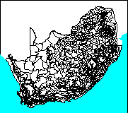 | - | -2319994S |
| -3887430S | . | . | . | -3887430S |
| -814124W | . | 957589E |
Projection information (see end of this page for details)
Projection ALBERS
latitude of projection's origin 0 0 0.000
Units METERS Spheroid CLARKE1866
Scale
1000000
Date
1987
Description
South African 712 climate zones
Owner
Department of Agricultural Engineering, Natal University
Owner_address
Computing Centre for Water Research
University of Natal
PIETERMARITZBURG
3201
Owner_contact
Mark Dent
Owner_country
South Africa
Owner_phone
(0331) 260 5177/8/9
Owner_fax
(0331) 61 896
Owner_email
dent@aqua.ccwr.ac.za
Disclaimer
No responsibility for the accuracy of the data is accepted.
Copyright_message
Raw data from a variety of State and private sources, including
the South African Weather Bureau, the Department of Agriculture and Water
Supply, the South African Sugar Association, organised agriculture and
individuals.
Copyright_warning
Data products obtained from or through the CCWR may only be used
for water research.
History
The boundaries of the climate zones were painstakingly estimated using an

underlay of topography and a plot of the mean annual precipitation of all

long term rainfall stations.  Care was taken to make the zones as small as

possible in mountainous terrain.  However, one of the major criteria was that

each zone should contain a good long term daily rainfall station.  For this

reason some of the smaller zones in mountainous areas have a wide range of

altitudes and mean annual rainfall values.  The zones in Lesotho are an

example of this shortcoming.

1988 - Water Research Commission report number 118/1/88

       (MC Dent, RE Schulze, GR Angus:  Crop water requirements,

        deficits and water yeild for irrigation planning in Southern Africa.)

1989 - Water Research Commission report number 109/1/89

       (MC Dent, SD Lynch, RE Schulze, AW Seed, HMM Wills:

        Mapping mean annual and other rainfall statistics over

        Southern Africa).

1994 - Updated zone boundaries obtained from CCWR.

1995 - Zone rainfall and temperature characteristics obtained from CCWR

       and combined with zone boundaries to form a polygon coverage

       (Michael Silberbauer, IWQS)

  Logo
 ../images/univnatl
Annotation items, 1kbyte:
12 May 1994, elise:
Arc items, 56kbyte:
12 May 1994, elise:
7 data fields
| ITEM | EXAMPLES | WIDTH | TYPE | REDEFINED? | INDEXED? |
|---|
| FNODE# | 2 | 4.0 | binary | | |
| TNODE# | 1 | 4.0 | binary | | |
| LPOLY# | 1 | 4.0 | binary | | |
| RPOLY# | 2 | 4.0 | binary | | |
| LENGTH | 158561.671875 | 4.3 | floatpnt | | |
| CLIMATE# | 1 | 4.0 | binary | | |
| CLIMATE-ID | 690 | 4.0 | binary | | |
Polygon items, 22kbyte:
3 Jul 1995, elise:
7 data fields
| ITEM | EXAMPLES | WIDTH | TYPE | REDEFINED? | INDEXED? |
|---|
| AREA | 2267292928 | 4.3 | floatpnt | | |
| PERIMETER | 6796483 | 4.3 | floatpnt | | |
| CLIMATE# | 1 | 4.0 | binary | | |
| CLIMATE-ID | 690 | 4.0 | binary | | |
| ZONE | 14 | 5.0 | integer | | (Indexed) |
| DESCRIPTION | 690 | 6.0 | integer | | |
| SYMBOL | 14 | 5.0 | integer | | |
Map specifications:
  Description of SINGLE precision coverage /spek/waterm/wmdata/general/climate

                                FEATURE CLASSES

                                    Number of  Attribute     Spatial
Feature Class          Subclass     Features   data (bytes)  Index?   Topology?
-------------          --------     ---------  ------------  -------  ---------
ARCS                                     2047        28
POLYGONS                                  713        32               Yes
NODES                                    1346
ANNOTATIONS             (blank)             0

                               SECONDARY FEATURES

Tics                                        4
Arc Segments                            67158
Polygon Labels                            712

                                   TOLERANCES

Fuzzy   =               194.352 V          Dangle  =                 0.000 N

                               COVERAGE BOUNDARY

Xmin =              -733592.000            Xmax =               877056.688
Ymin =             -3806897.250            Ymax =             -2400526.750

                                     STATUS

The coverage has not been Edited since the last BUILD or CLEAN.

                          COORDINATE SYSTEM DESCRIPTION

Projection               ALBERS
Units                    METERS             Spheroid             CLARKE1866
Parameters:
1st standard parallel                                  -18  0  0.000
2nd standard parallel                                  -32  0  0.000
central meridian                                        24  0  0.000
latitude of projection's origin                          0  0  0.000
false easting (meters)                                       0.00000
false northing (meters)                                      0.00000