Regions of Department of Water and Sanitation (interim)
dwafreg
Institute for Water Quality Studies metadata.
Summary created by Elna with catalog.aml on 1999-04-01 - 14:32:54
File owner: elise, last modified: 1 Apr (less than 1yr ago)
Map extent:
| -1432172W | . | 1384198E |
| -1551264S | - | 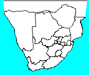 | - | -1551264S |
| -3934894S | . | . | . | -3934894S |
| -1432172W | . | 1384198E |
Projection information (see end of this page for details)
Projection ALBERS
latitude of projection's origin 0 0 0.000
Units METERS Spheroid CLARKE1880
Scale
500000
Date
1998-05
Description
Regions of Department of Water and Sanitation (interim)
Owner
Department of Water and Sanitation
Owner_address
Department of Water and Sanitation
Private Bag X313
PRETORIA
0001
Owner_contact
Frans le Roux, Boskop Office (Potchefstroom)
Owner_country
South Africa
Owner_phone
(0148) 298 1113
Owner_fax
(0148) 298 1175
Owner_email
Disclaimer
No responsibility for the accuracy of this temporary data set is accepted.
Copyright_message
Used provincial boundaries
Copyright_warning
Use at own risk
History
1997 - Frans le Roux compiled and digitised map from information

       supplied by the provincial regions of DWAF. DRAFT MAP!!!

1997 - Michael Silberbauer used this map to generate an even less

       accurate map, using the original provincial borders as a guide.

       This process introduced additional errors, up to 2.5 km.

       Poly attributes CLASS: DWAF region or Country

                       NAME : Name in upper case

                       DWAF_REGION : Name of region in proper case

                       DWAF_SUBREG : Name of sub-region in proper case

       Arc attributes  TYPE : I = international border (no river)

                              i = international border (river)

                              C = coastline

                              X = imaginary line to close polygon

                              R = regional boundary (not on province border)

                              r = regional boundary (same as province)

                              S = sub-regional boundary

1998 - Michael Silberbauer added Gauteng sub-regions and modified Gauteng region border

  Logo
 $WMSYS/ptool/template/dwaf_logo
Arc items, 5kbyte:
15 May 1998, elise:
8 data fields
| ITEM | EXAMPLES | WIDTH | TYPE | REDEFINED? | INDEXED? |
|---|
| FNODE# | 1 | 4.0 | binary | | |
| TNODE# | 2 | 4.0 | binary | | |
| LPOLY# | 1 | 4.0 | binary | | |
| RPOLY# | 4 | 4.0 | binary | | |
| LENGTH | 1736.094360351 | 4.3 | floatpnt | | |
| DWAFREG# | 1 | 4.0 | binary | | |
| DWAFREG-ID | 71 | 4.0 | binary | | |
| TYPE | I | 1 | character | | |
Polygon items, 7kbyte:
15 May 1998, elise:
9 data fields
| ITEM | EXAMPLES | WIDTH | TYPE | REDEFINED? | INDEXED? |
|---|
| AREA | 390645579776 | 4.3 | floatpnt | | |
| PERIMETER | 10915386 | 4.3 | floatpnt | | |
| DWAFREG# | 1 | 4.0 | binary | | |
| DWAFREG-ID | 11 | 4.0 | binary | | |
| NAME | ZIMBABWE | 40 | character | | |
| CLASS | Country | 40 | character | | |
| Z | 0 | 4.0 | binary | | |
| DWAF_REGION | 'Northern Province' | 40 | character | | |
| DWAF_SUBREG | Gauteng_N | 40 | character | | |
Map specifications:
  Description of SINGLE precision coverage /spek/waterm/wmdata/general/dwafreg

                                FEATURE CLASSES

                                    Number of  Attribute     Spatial
Feature Class          Subclass     Features   data (bytes)  Index?   Topology?
-------------          --------     ---------  ------------  -------  ---------
ARCS                                      187        30
POLYGONS                                   37       180               Yes
NODES                                     545

                               SECONDARY FEATURES

Tics                                        4
Arc Segments                            52813
Polygon Labels                             36

                                   TOLERANCES

Fuzzy   =                 0.760 V          Dangle  =                 0.000 V

                               COVERAGE BOUNDARY

Xmin =             -1304155.375            Xmax =              1256181.375
Ymin =             -3806877.500            Ymax =             -1679280.375

                                     STATUS

The coverage has not been Edited since the last BUILD or CLEAN.

                          COORDINATE SYSTEM DESCRIPTION

Projection               ALBERS
Units                    METERS             Spheroid             CLARKE1880
Parameters:
1st standard parallel                                  -18  0  0.000
2nd standard parallel                                  -32  0  0.000
central meridian                                        24  0  0.000
latitude of projection's origin                          0  0  0.000
false easting (meters)                                       0.00000
false northing (meters)                                      0.00000