| 10E | . | 45E | ||
| -10S | - | | - | -10S |
| -40S | . | . | . | -40S |
| 10E | . | 45E |
Projection information (see end of this page for details)
Projection ALBERS
latitude of projection's origin 0 0 0.000
Units METERS Spheroid CLARKE1880
Scale
1000000
Date
1995
Description
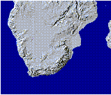
Hillshaded relief grid
Owner
Customer Services EROS Data Center
Owner_address
Customer Services
EROS Data Center
Mundt Federal Building
Sioux Falls, SD 57198
Owner_contact
FTP to 152.61.128.6 (edcftp.cr.usgs.gov)
Owner_country
United States of America
Owner_phone
(605) 594-6151
Owner_fax
(605) 594-6589
Owner_email
klarson@dgl.cr.usgs.gov, jenson@dg1.cr.usgs.gov
Owner_website
http://edcwww.cr.usgs.gov/landdaac/gtopo30/README.html
http://edcwww.cr.usgs.gov/landdaac/gtopo30/README.html
Disclaimer
No responsibility is accepted for the accuracy of this data
Copyright_message
USGS & EROS
Copyright_warning
data in the public domain
History
This is a reclassed version of the USGS African DEM.

The following are extracts from the README and README_v2.txt files that

came with the 1995 and 1996 DEMs supplied by EROS Data Centre.

The DCW DEM data were created by the EROS Data Center by running

DCW contour, point elevation, and hydrology data through the ANUDEM digital

elevation model generation program.

A Digital Elevation Model (DEM) consists of a sampled array of elevations

for ground positions that are normally at regularly spaced intervals.  The

Digital Chart of the World (DCW) DEM data provide 30-by-30 arc-second

digital elevation data produced from the Defense Mapping Agency's (DMA)

1:1,000,000-scale DCW contour and hydrology data.  The EROS Data Center's

DCW DEM project includes generation of 30 arc-second data for the entire

world to be distributed on CD-ROM as major geographic regions are completed.

As of July 1, 1995 Africa, North America, Japan, Madagascar, and Haiti, are

complete and available for distribution.

Digital Chart of the World (DCW) Digital Elevation Model (DEM) data are

produced from 1:1,000,000-scale DCW contour, point elevation, and hydrology

data layers.

The map source for the DCW database is the U.S. Defense Mapping Agency

DMA)'s Operational Navigation Chart (ONC) series.  This is the largest-

scale map series  that provides consistent, continuous global coverage of

essential basemap features.

Data Characteristics

Spatial Resolution

Spacing of the elevations along and between each sample is 30-arc-seconds

(approximately 1 km).  The horizontal datum is WGS84.  Elevation values

are expressed in feet above mean sea level.

Accuracy

The absolute accuracy of the DCW vector information is 2000 meters circular

error (horizontal) and + or - 650 meters linear error (vertical) at 90-percent

confidence as defined by the Defense Mapping Agency (DMA).  The grid generated

from these data will be no more accurate than this source.  The accuracy for

the grid has not been measured or calculated.

Moderate resolution (100 meter to 1 kilometer) topographic data have

applications in many diverse land science fields such as geology and

geophysics, ecology, soil science, botany, and glaciology.  Topographic data

are also critical to procedures used for correcting and/or presenting remotely

sensed satellite and other global data.

The DCW DEM data, produced for use in conducting large-area studies, has

been generated at a resolution which is compatible with the Advanced Very

High Resolution Radiometer (AVHRR) sensor.

References

Defense Mapping Agency, 1992, Development of the Digital Chart of the

World: Washington, D.C., U.S. Government Printing Office.

Environmental Systems Research Institute, 1991, Image Integration ARC/INFO

User's Guide: Redlands, California, Environmental Systems Research

Institute, Inc.

Hutchinson, M.F., 1988, Calculation of hydrologically sound digital

elevation models: Proc. Third Inter. Symp. Spatial Data Handling,

Columbus, Ohio, August 17-19.

Hutchinson, M.F., 1989, A new method for gridding elevation and stream

line data with automatic removal of pits: J. Hydrol, 106, 211-232 p.

Hutchinson, M.F., 1991, A continental hydrological assessment of a new grid-

based digital elevation model of Australia: Hydrological Processes 5, 45-58 p.


README_v2.txt   3/6/96


PLEASE NOTE:  This is an interim release of an updated portion of the Africa

30 arc second DEM.  The Africa 30 arc second DEM was originally released in

October 1994, and an update was released in August 1995.  The complete Africa

DEM was constructed by gridding Digital Chart of the World (DCW) data.  For a

description of that processing please see the README file at edcftp.cr.usgs.gov

in the directory /pub/data/30ASDCWDEM/AFRICA.  The data set described here is

derived from a different source, Digital Terrain Elevation Data, and it will

be used eventually to update the Africa 30 arc second DEM.  Comments from

users of this data set are welcome.  Please contact Dean Gesch

(gesch@dg1.cr.usgs.gov) or Sue Jenson (jenson@dg1.cr.usgs.gov) with your

comments.

The 3 arc second grids were aggregated to 30 arc second grids using a cell

factor of 10 and mean as the aggregation type.  Thus, the value for a specific

30 arc second cell represents the mean of 100 full resolution 3 arc second

cells.  To deal with the boundaries of the input grid when its rows and/or

columns are not a multiple of the cell factor, the "truncate" option was used.

This option reduces the number of rows and/or columns in the output grid by

one.  Doing so truncates the remaining cells on the bottom and/or right

boundaries of the input grid thus making the number of rows and/or columns in

the input grid a multiple of the cell factor.  The resulting output grid's

spatial extent can thus be smaller than the input grid.  The "nodata" option

used specifies that if any cell that falls within the spatial extent of a

larger cell on the output grid has a value of "no data", then the value for

that output cell location will be no data.  The final assembly step involved

mosaicing together the individual 30 arc second grids.

DEM Coverage and Characteristics

The generalized DTED covers about 50% of the African continent.  However, the

coverage is in an irregular pattern so this interim DEM extends across the

entire continent.  The DEM extends from 18 degrees west to 50 degrees east

longitude, and from 35 degrees south to 42 degrees north latitude.  There is

a GIF image named af_dem_v2.gif at edcftp.cr.usgs.gov in the directory

/pub/data/30ASDCWDEM/AFRICA which shows the coverage of the DEM.  In the DEM,

background ("no data") and ocean areas have a value of -9999.  The cell values

represent elevation in meters above mean sea level.  The values range from

-405 to 4429.  The horizontal coordinate system is latitude/longitude

referenced to WGS84.  The posting interval (cell size) is 30 arc seconds

(0.0083333333333 degrees).  The DEM file has dimensions of 9240 rows by 8160

columns.

  Logo
 ../images/gtopo30.jpg
    Description of SINGLE precision coverage $WMSYS/wmdata/general/grdshade

                          Description of Grid GRDSHADE

Cell Size =             500.000         Data Type:                   Integer
Number of Rows    =        6063           Number of Values =              27
Number of Columns =        7035           Attribute Data (bytes) =         8

           BOUNDARY                                STATISTICS

Xmin =             -1457197.621         Minimum Value =                1.000
Xmax =              2060302.379         Maximum Value =              100.000
Ymin =             -4072819.596         Mean          =               53.806
Ymax =             -1041319.596         Standard Deviation =           1.716

                          COORDINATE SYSTEM DESCRIPTION

Projection               ALBERS
Units                    METERS             Spheroid             CLARKE1880
Parameters:
1st standard parallel                                  -18  0  0.000
2nd standard parallel                                  -32  0  0.000
central meridian                                        24  0  0.000
latitude of projection's origin                          0  0  0.000
false easting (meters)                                       0.00000
false northing (meters)                                      0.00000