Geology map of South Africa with simplified lithostratigraphy for geohydrological use
hgh_1000
Institute for Water Quality Studies metadata.
Summary created by Elna with catalog.aml on 1999-04-01 - 14:35:34
File owner: elise, last modified: 1 Apr (less than 1yr ago)
Map extent:
| -844886W | . | 964023E |
| -2317957S | - | 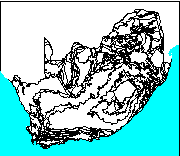 | - | -2317957S |
| -3889780S | . | . | . | -3889780S |
| -844886W | . | 964023E |
Projection information (see end of this page for details)
Projection ALBERS
latitude of projection's origin 0 0 0.000
Units METERS Spheroid CLARKE1880
Scale
1000000
Date
1995
Description
Geology map of South Africa with simplified lithostratigraphy for geohydrological use
Owner
Water Research Commission & Department of Water and Sanitation
Owner_address
The Water Research Commission,
PO Box 824
PRETORIA
0001
Owner_contact
The Executive Officer
Owner_country
South Africa
Owner_phone
(021) 330 0340
Owner_fax
(021) 331 2565
Owner_email
xxx@aqua.ccwr.ac.za
Disclaimer
This coverage represents groundwater on a regional scale, is not site-specific
and cannot be used for borehole siting or deducing any other site-specific
condition
Copyright_message
Portions of this work include intellectual property of the Council for
Geoscience, the Water Research Commission & the Department of Water and Sanitation.
Copyright_warning
Copyright data - not in the public domain
Copies of digital data may not be given to third parties
History
1994 Simplified lithostratigraphy digitised by A Havenga, Council for

     Geosciences

1995 Water Research Commission TT 74/95 report and 2 maps by JR Vegter:

     "An explanation of a set of national groundwater maps" and "Groundwater

     resources of the Republic of South Africa" sheets 1 & 2.

  Logo
 /hri/db/clip/wrc.tif
Arc items, 40kbyte:
17 Apr 1996, elise:
8 data fields
| ITEM | EXAMPLES | WIDTH | TYPE | REDEFINED? | INDEXED? |
|---|
| FNODE# | 1 | 4.0 | binary | | |
| TNODE# | 2 | 4.0 | binary | | |
| LPOLY# | 2 | 4.0 | binary | | |
| RPOLY# | 1 | 4.0 | binary | | |
| LENGTH | 87430.0390625 | 4.3 | floatpnt | | |
| HGH_1000# | 1 | 4.0 | binary | | |
| HGH_1000-ID | 10 | 4.0 | binary | | |
| LIN | 59 | 4.0 | binary | | |
Polygon items, 14kbyte:
18 Apr 1996, elise:
9 data fields
| ITEM | EXAMPLES | WIDTH | TYPE | REDEFINED? | INDEXED? |
|---|
| AREA | 1498977664 | 4.3 | floatpnt | | |
| PERIMETER | 6918848 | 4.3 | floatpnt | | |
| HGH_1000# | 1 | 4.0 | binary | | |
| HGH_1000-ID | 999 | 4.0 | binary | | |
| KEY | 1 | 4.0 | binary | | |
| LITHO | 10 | 4.0 | binary | | |
| ROCK | 5 | 2.0 | integer | | |
| METDEF | 1 | 4.0 | binary | | |
| LABEL | PTRu | 6 | character | | |
Map specifications:
 Description of SINGLE precision coverage /spek/waterm/wmdata/general/hgh_1000

                                FEATURE CLASSES

                                    Number of  Attribute     Spatial
Feature Class          Subclass     Features   data (bytes)  Index?   Topology?
-------------          --------     ---------  ------------  -------  ---------
ARCS                                     1279        32
POLYGONS                                  390        36      Yes      Yes
NODES                                     938

                               SECONDARY FEATURES

Tics                                       18
Arc Segments                            55107
Polygon Labels                            369

                                   TOLERANCES

Fuzzy   =                 0.751 V          Dangle  =                 0.001 N

                               COVERAGE BOUNDARY

Xmin =              -762662.688            Xmax =               881800.062
Ymin =             -3807556.750            Ymax =             -2400180.250

                                     STATUS

The coverage has not been Edited since the last BUILD or CLEAN.

                          COORDINATE SYSTEM DESCRIPTION

Projection               ALBERS
Units                    METERS             Spheroid             CLARKE1880
Parameters:
1st standard parallel                                  -18  0  0.000
2nd standard parallel                                  -32  0  0.000
central meridian                                        24  0  0.000
latitude of projection's origin                          0  0  0.000
false easting (meters)                                       0.00000
false northing (meters)                                      0.00000