South African magisterial districts
magisterial
Institute for Water Quality Studies metadata.
Summary created by Elna with catalog.aml on 1999-04-01 - 14:50:51
File owner: elise, last modified: 1 Apr (less than 1yr ago)
Map extent:
| -1071109W | . | 970636E |
| -2298931S | - | 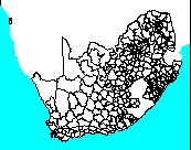 | - | -2298931S |
| -3907387S | . | . | . | -3907387S |
| -1071109W | . | 970636E |
Projection information (see end of this page for details)
Projection ALBERS
latitude of projection's origin 0 0 0.000
Units METERS Spheroid CLARKE1866
Scale
250000?
Date
1994
Description
South African magisterial districts
Owner
Chief Directorate of Surveys and Land Information
Owner_address
Department of Land Affairs
Private Bag
MOWBRAY
7705
Owner_contact
Thomas Krieg
Owner_country
South Africa
Owner_phone
(021) 685 4070 x 143
Owner_fax
(021) 689 1351
Owner_email
xxx@xxx.xxx.gov.za
Disclaimer
Copyright_message
State Copyright
Copyright_warning
State data - not in the public domain
Copies of digital data may not be given to third parties
History
1994 - Digital data supplied to Department of Water and Sanitation

  Logo
 ../images/s&li
Annotation items, 1kbyte:
13 Sep 1994, elise:
Point items, 6kbyte:
13 Sep 1994, elise:
4 data fields
| ITEM | EXAMPLES | WIDTH | TYPE | REDEFINED? | INDEXED? |
|---|
| AREA | 0.4730047881603 | 4.3 | floatpnt | | |
| PERIMETER | 74.060546875 | 4.3 | floatpnt | | |
| MAGISTERIAL# | 1 | 4.0 | binary | | |
| MAGISTERIAL-ID | 1 | 4.0 | binary | | |
Map specifications:
Description of SINGLE precision coverage /spek/waterm/wmdata/general/magisteria

                                FEATURE CLASSES

                                    Number of  Attribute     Spatial
Feature Class          Subclass     Features   data (bytes)  Index?   Topology?
-------------          --------     ---------  ------------  -------  ---------
ARCS                                     1059
POLYGONS                                  353        16             Preliminary
NODES                                     712
ANNOTATIONS             (blank)             0

                               SECONDARY FEATURES

Tics                                       20
Arc Segments                            85123
Polygon Labels                            350

                                   TOLERANCES

Fuzzy   =                46.263 N          Dangle  =                 0.000 N

                               COVERAGE BOUNDARY

Xmin =              -978302.125            Xmax =               877829.438
Ymin =             -3814580.250            Ymax =             -2391737.750

                                     STATUS

Use BUILD or CLEAN to create Topology from Preliminary POLYGONS.

                          COORDINATE SYSTEM DESCRIPTION

Projection               ALBERS
Units                    METERS             Spheroid             CLARKE1866
Parameters:
1st standard parallel                                  -18  0  0.000
2nd standard parallel                                  -32  0  0.000
central meridian                                        24  0  0.000
latitude of projection's origin                          0  0  0.000
false easting (meters)                                       0.00000
false northing (meters)                                      0.00000