Evaporation (mean annual) of South Africa (WR90 file eip.e00)
mav_wr90
Institute for Water Quality Studies metadata.
Summary created by Elna with catalog.aml on 1999-04-01 - 14:51:32
File owner: elise, last modified: 1 Apr (less than 1yr ago)
Map extent:
| -812443W | . | 957172E |
| -2319505S | - | 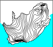 | - | -2319505S |
| -3887336S | . | . | . | -3887336S |
| -812443W | . | 957172E |
Projection information (see end of this page for details)
Projection ALBERS
latitude of projection's origin 0 0 0.000
Units METERS Spheroid CLARKE1880
Scale
1000000
Date
1990
Description
Evaporation (mean annual) of South Africa (WR90 file eip.e00)
Owner
Water Research Commission
Owner_address
Water Research Commission
PO Box 824
PRETORIA
0001
Owner_contact
Hugo Maaren
Owner_country
South Africa
Owner_phone
(012) 330 0340
Owner_fax
(012)
Owner_email
hugo@wrc.ccwr.ac.za
Disclaimer
No responsibility for the accuracy of the data is accepted.
Copyright_message
Raw data from a variety of State and private sources, including
the South African Weather Bureau, the Department of Agriculture and Water
Supply, the South African Sugar Association, organised agriculture and
individuals.
Copyright_warning
Data products may only be used for water research.
History
1996 - Water Research Commission report number 298/1/94

       (DC Midgley, WV Pitman & BJ Middleton, Surface Water Resources of

        South Africa 1990 - User's Manual - ISBN 1 86845 143 7)

1996 - EVAPCODE field added (1 to 11 with increasing evaporation)

       - Mike Silberbauer.

  Logo
 $WMSYS/ptool/template/wrc_logo
Annotation items, 8kbyte:
12 Dec 1996, elise:
Arc items, 6kbyte:
12 Dec 1996, elise:
8 data fields
| ITEM | EXAMPLES | WIDTH | TYPE | REDEFINED? | INDEXED? |
|---|
| FNODE# | 1 | 4.0 | binary | | |
| TNODE# | 2 | 4.0 | binary | | |
| LPOLY# | 1 | 4.0 | binary | | |
| RPOLY# | 2 | 4.0 | binary | | |
| LENGTH | 46292.328125 | 4.3 | floatpnt | | |
| MAV_WR90# | 1 | 4.0 | binary | | |
| MAV_WR90-ID | 1400 | 4.0 | binary | | |
| MAE | 1400 | 5.0 | integer | | |
Polygon items, 2kbyte:
13 Dec 1996, elise:
8 data fields
| ITEM | EXAMPLES | WIDTH | TYPE | REDEFINED? | INDEXED? |
|---|
| AREA | 9200565248 | 4.3 | floatpnt | | |
| PERIMETER | 7036608 | 4.3 | floatpnt | | |
| MAV_WR90# | 1 | 4.0 | binary | | |
| MAV_WR90-ID | 84 | 4.0 | binary | | |
| COLOR | 84 | 3.0 | integer | | |
| RANGE | '2000-2200 mm' | 20 | character | | |
| EVAPCODE | 9 | 4.0 | binary | | |
| CODE | 9 | 3.0 | integer | | (Indexed) |
Map specifications:
 Description of SINGLE precision coverage /spek/waterm/wmdata/general/mav_wr90

                                FEATURE CLASSES

                                    Number of  Attribute     Spatial
Feature Class          Subclass     Features   data (bytes)  Index?   Topology?
-------------          --------     ---------  ------------  -------  ---------
ARCS                                      180        34
POLYGONS                                   43        46      Yes      Yes
NODES                                     149
ANNOTATIONS             (blank)            47

                               SECONDARY FEATURES

Tics                                     4150
Arc Segments                            33609
Polygon Labels                             42

                                   TOLERANCES

Fuzzy   =                 1.008 V          Dangle  =                 1.008 N

                               COVERAGE BOUNDARY

Xmin =              -732005.938            Xmax =               876734.812
Ymin =             -3806899.250            Ymax =             -2399942.500

                                     STATUS

The coverage has not been Edited since the last BUILD or CLEAN.

                          COORDINATE SYSTEM DESCRIPTION

Projection               ALBERS
Units                    METERS             Spheroid             CLARKE1880
Parameters:
1st standard parallel                                  -18  0  0.000
2nd standard parallel                                  -32  0  0.000
central meridian                                        24  0  0.000
latitude of projection's origin                          0  0  0.000
false easting (meters)                                       0.00000
false northing (meters)                                      0.00000