Copyright_message
State Copyright
Copyright_warning
State data - not in the public domain - except DWAF polygons!
Copies of digital data may not be given to third parties
History
1994 - Digital data supplied to Department of Water and Sanitation
1995 - Dam polygons closed by GisLAB
1995 - Dams cleaned and named by IWQS (over-cleaned?)
1996 - Dams fixed and stations added by IWQS (mjs)
1996 - Extra dams & lakes added from satellite images
1999 - Extra dams added from 1:50 000 blue plate coverage
- Some 1:500 000 arcsreplaced by 1:50 000 arcs
- Errors in station numbers fixed
- TYPE field added
- Z field used for metadata
Attributes
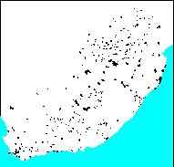
Polygons:
TYPE - ISLAND, RESERVOIR, NATURAL
NAME - Most current name, with best possible spelling
STATION - Department of Water and Sanitation hydrological code
- the presence of a station number does not imply that
flow or quality data exists.
Arcs:
Z - 500 = from 1:500 000 scanned blue plates
- 50 = from 1:50 000 scanned blue plates
Logo
 ../images/s&li
Arc items, 197kbyte:
8 Jun (less than 1yr ago), michael:
11 data fields
| ITEM | EXAMPLES | WIDTH | TYPE | REDEFINED? | INDEXED? |
|---|
| FNODE# | 1 | 4.0 | binary | | |
| TNODE# | 2 | 4.0 | binary | | |
| LPOLY# | 1 | 4.0 | binary | | |
| RPOLY# | 1 | 4.0 | binary | | |
| LENGTH | 13.8125 | 4.3 | floatpnt | | |
| WLA_500# | 1 | 4.0 | binary | | |
| WLA_500-ID | 10 | 4.0 | binary | | |
| NAME | ?? | 40 | character | | |
| CLASS | Dam_Wall | 40 | character | | |
| Z | 50 | 4.0 | binary | | |
| TYPE | ' ' | 10 | character | | |
Polygon items, 38kbyte:
8 Jun (less than 1yr ago), michael:
16 data fields
| ITEM | EXAMPLES | WIDTH | TYPE | REDEFINED? | INDEXED? |
|---|
| AREA | 207110.625 | 4.3 | floatpnt | | |
| PERIMETER | 7587373.5 | 4.3 | floatpnt | | |
| WLA_500# | 1 | 4.0 | binary | | |
| WLA_500-ID | 1 | 4.0 | binary | | |
| STATION | A7R001Q01 | 9 | character | | |
| NAME | 'Dr Neethling' | 40 | character | | |
| X-COORD | 30.41140556335 | 4.3 | floatpnt | | |
| Y-COORD | 0 | 4.3 | floatpnt | | |
| TYPE | RESERVOIR | 10 | character | | |
| STN | A7R001 | 6 | character | (ReDefined) | |
| PRIMARY | A | 1 | character | (ReDefined) | |
| SECONDARY | A7 | 2 | character | (ReDefined) | |
| STNTYPE | R | 1 | character | (ReDefined) | |
| MONPTNUM | 001 | 3 | character | (ReDefined) | |
| MONITYPE | Q | 1 | character | (ReDefined) | |
| SUBMONPT | 01 | 2 | character | (ReDefined) | |
Map specifications:
    Description of SINGLE precision coverage wla_500

                                FEATURE CLASSES

                                    Number of  Attribute     Spatial
Feature Class          Subclass     Features   data (bytes)  Index?   Topology?
-------------          --------     ---------  ------------  -------  ---------
ARCS                                     1653       122
POLYGONS                                  464        84               Yes
NODES                                    1646

                               SECONDARY FEATURES

Tics                                      247
Arc Segments                           209317
Polygon Labels                            464

                                   TOLERANCES

Fuzzy   =                 0.745 V          Dangle  =                 0.000 N

                               COVERAGE BOUNDARY

Xmin =              -531508.875            Xmax =               875661.875
Ymin =             -3790918.000            Ymax =             -2446659.500

                                     STATUS

The coverage has not been Edited since the last BUILD or CLEAN.

                          COORDINATE SYSTEM DESCRIPTION

Projection               ALBERS
Units                    METERS             Spheroid             CLARKE1880
Parameters:
1st standard parallel                                  -18  0  0.000
2nd standard parallel                                  -32  0  0.000
central meridian                                        24  0  0.000
latitude of projection's origin                          0  0  0.000
false easting (meters)                                       0.00000
false northing (meters)                                      0.00000