Copyright_message
State Copyright
Copyright_warning
State data - not in the public domain
Copies of digital data may not be given to third parties
History
1994 - Digital data supplied to Department of Water and Sanitation
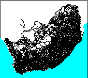
1995 - Rivers selected to match national monitoring network by GisLAB
- Gaps in rivers at dams closed
- Rivers made to point downstream
- River names checked
- WARNING - may be wrong spheroid (Clarke1866) which means errors up to
100 metres in furthest extremities.
Logo
 ../images/s&li
Arc items, 1065kbyte:
31 Oct 1995, elise:
12 data fields
| ITEM | EXAMPLES | WIDTH | TYPE | REDEFINED? | INDEXED? |
|---|
| FNODE# | 1 | 4.0 | binary | | |
| TNODE# | 3 | 4.0 | binary | | |
| LPOLY# | 2 | 4.0 | binary | | |
| RPOLY# | 2 | 4.0 | binary | | |
| LENGTH | 6301.582519531 | 4.3 | floatpnt | | |
| WRI_500# | 1 | 4.0 | binary | | |
| WRI_500-ID | 991 | 4.0 | binary | | |
| NAME | Limpopo | 40 | character | | (Indexed) |
| CLASS | Perennial_river | 40 | character | | |
| Z | 0 | 4.0 | binary | | |
| ORDER | 5 | 4.0 | binary | | (Indexed) |
| PRIMARY | A | 1 | character | | |
Map specifications:
  Description of SINGLE precision coverage /spek/waterm/wmdata/general/wri_500

                                FEATURE CLASSES

                                    Number of  Attribute     Spatial
Feature Class          Subclass     Features   data (bytes)  Index?   Topology?
-------------          --------     ---------  ------------  -------  ---------
ARCS                                     9238       118      Yes
NODES                                   43824

                               SECONDARY FEATURES

Tics                                     1167
Arc Segments                           380877

                                   TOLERANCES

Fuzzy   =               160.035 N          Dangle  =                 0.000 N

                               COVERAGE BOUNDARY

Xmin =              -732005.938            Xmax =               868341.750
Ymin =             -3800511.750            Ymax =             -2399942.500

                                     STATUS

The coverage has not been Edited since the last BUILD or CLEAN.

                          COORDINATE SYSTEM DESCRIPTION

Projection               ALBERS
Units                    METERS             Spheroid             CLARKE1866
Parameters:
1st standard parallel                                  -18  0  0.000
2nd standard parallel                                  -32  0  0.000
central meridian                                        24  0  0.000
latitude of projection's origin                          0  0  0.000
false easting (meters)                                       0.00000
false northing (meters)                                      0.00000