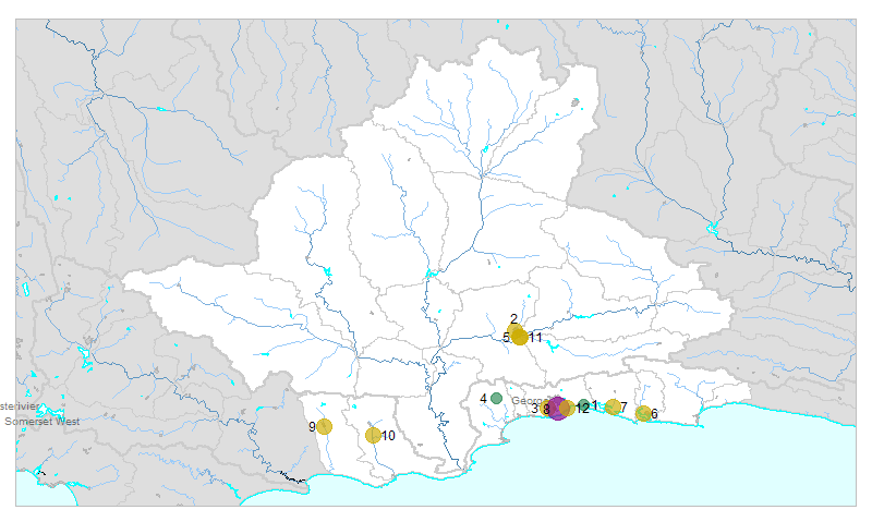
| № |
Site
[
view Gouritz sites in Google Earth
]
|
Plot all data |
Date |
MPN, or cfu / 100mL
|
Turb.
NTU |
pH |
Temp.
oC |
Risk based on E. coli if recorded, otherwise on faecal coliforms |
| E. coli |
faecal coliforms |
drinking-
no treatment |
drinking-
limited treatment |
full or
partial
contact |
irrigation-
crops eaten raw |
| 1 | 102267 [2-month plot]
Lower Lang Vlei at Glentyre at Boat Slipway West Shore |

|
2010-09-13 |
6 |
- |
- |
6.0 |
- |
Med |
low |
low |
low |
| 1 | 102267 | |
2010-09-27 |
2 |
- |
- |
5.0 |
- |
Med |
low |
low |
low |
| 1 | 102267 | |
2010-10-11 |
1986 |
- |
- |
6.0 |
- |
HIGH |
low |
HIGH |
Med |
| 1 | 102267 | |
2010-10-25 |
58 |
- |
- |
6.0 |
- |
HIGH |
low |
low |
low |
| 2 | 189533 [2-month plot]
Oudtshoorn at Low Water Bridge Next to ATKV Theater on Grobbelaars |

|
2010-09-28 |
155 |
- |
- |
6.0 |
- |
HIGH |
low |
low |
low |
| 2 | 189533 | |
2010-10-11 |
866 |
- |
- |
6.0 |
- |
HIGH |
low |
HIGH |
low |
| 2 | 189533 | |
2010-10-26 |
1046 |
- |
- |
6.0 |
- |
HIGH |
low |
HIGH |
Med |
| 3 | 189534 [2-month plot]
- Gwayang D/S of STW at Causeway on Gwaingrivier |

|
2010-09-13 |
2420 |
- |
- |
5.0 |
- |
HIGH |
Med |
HIGH |
Med |
| 3 | 189534 | |
2010-09-27 |
291 |
- |
- |
7.0 |
- |
HIGH |
low |
Med |
low |
| 3 | 189534 | |
2010-10-25 |
6131 |
- |
- |
6.0 |
- |
HIGH |
Med |
HIGH |
HIGH |
| 4 | 189536 [2-month plot]
Leeukloof at Low Water Bridge on Paardekoprivier |

|
2010-09-21 |
21 |
- |
- |
6.0 |
- |
HIGH |
low |
low |
low |
| 4 | 189536 | |
2010-09-27 |
20 |
- |
- |
5.0 |
- |
HIGH |
low |
low |
low |
| 4 | 189536 | |
2010-10-11 |
185 |
- |
- |
6.0 |
- |
HIGH |
low |
low |
low |
| 4 | 189536 | |
2010-10-25 |
102 |
- |
- |
5.0 |
- |
HIGH |
low |
low |
low |
| 5 | 190521 [2-month plot]
Onverwacht 143 at Bridge on George Road (R62) on Olifants River |

|
2010-09-28 |
197 |
- |
- |
6.5 |
- |
HIGH |
low |
low |
low |
| 5 | 190521 | |
2010-10-11 |
1986 |
- |
- |
6.0 |
- |
HIGH |
low |
HIGH |
Med |
| 5 | 190521 | |
2010-10-26 |
3654 |
- |
- |
7.5 |
- |
HIGH |
Med |
HIGH |
Med |
| 6 | 190523 [2-month plot]
Eastford South at Knysna/Sedgefield Road (N2) on Soutrivier Mouth |

|
2010-09-27 |
1733 |
- |
- |
6.0 |
- |
HIGH |
low |
HIGH |
Med |
| 6 | 190523 | |
2010-10-11 |
579 |
- |
- |
6.0 |
- |
HIGH |
low |
HIGH |
low |
| 6 | 190523 | |
2010-10-25 |
24200 |
- |
- |
6.0 |
- |
HIGH |
HIGH |
HIGH |
HIGH |
| 7 | 190524 [2-month plot]
- Eastbrook 183 at Road Bridge on Karatararivier |

|
2010-10-25 |
1935 |
- |
- |
6.0 |
- |
HIGH |
low |
HIGH |
Med |
| 8 | 190525 [2-month plot]
Sand Kraal 197 at Pacaltsdorp on Skaapkoprivier |

|
2010-09-13 |
24200 |
- |
- |
5.0 |
- |
HIGH |
HIGH |
HIGH |
HIGH |
| 8 | 190525 | |
2010-09-27 |
14136 |
- |
- |
7.0 |
- |
HIGH |
Med |
HIGH |
HIGH |
| 8 | 190525 | |
2010-10-12 |
17330 |
- |
- |
6.0 |
- |
HIGH |
Med |
HIGH |
HIGH |
| 8 | 190525 | |
2010-10-26 |
24200 |
- |
- |
6.0 |
- |
HIGH |
HIGH |
HIGH |
HIGH |
| 9 | 190526 [2-month plot]
- Heidelberg - D/S WWTW on Duiwenhoksrivier |

|
2010-09-16 |
1203 |
- |
- |
6.0 |
- |
HIGH |
low |
HIGH |
Med |
| 9 | 190526 | |
2010-09-28 |
24200 |
- |
- |
5.0 |
- |
HIGH |
HIGH |
HIGH |
HIGH |
| 9 | 190526 | |
2010-10-27 |
1046 |
- |
- |
5.0 |
- |
HIGH |
low |
HIGH |
Med |
| 10 | 190527 [2-month plot]
Soetmelksfontein 529 near Riversdale 300M from Brakrivier Confluence on Goukou |

|
2010-09-16 |
29 |
- |
- |
6.0 |
- |
HIGH |
low |
low |
low |
| 10 | 190527 | |
2010-09-28 |
420 |
- |
- |
5.0 |
- |
HIGH |
low |
HIGH |
low |
| 10 | 190527 | |
2010-10-27 |
2280 |
- |
- |
6.0 |
- |
HIGH |
Med |
HIGH |
Med |
| 11 | 190529 [2-month plot]
- Oudtshoorn - Onverwacht 143 Directly After Oudtshoorn WWTW Discharge Point on Olifants |

|
2010-09-28 |
538 |
- |
- |
6.0 |
- |
HIGH |
low |
HIGH |
low |
| 11 | 190529 | |
2010-10-11 |
5475 |
- |
- |
6.0 |
- |
HIGH |
Med |
HIGH |
HIGH |
| 11 | 190529 | |
2010-10-26 |
2420 |
- |
- |
6.5 |
- |
HIGH |
Med |
HIGH |
Med |
| 12 | 190530 [2-month plot]
Kraai Bosch 195 1KM from Ballotsbaai downstream of Confluence on Meulriver |

|
2010-09-13 |
1986 |
- |
- |
5.0 |
- |
HIGH |
low |
HIGH |
Med |
| 12 | 190530 | |
2010-09-27 |
167 |
- |
- |
7.0 |
- |
HIGH |
low |
low |
low |
| 12 | 190530 | |
2010-10-12 |
228 |
- |
- |
7.0 |
- |
HIGH |
low |
Med |
low |
| 12 | 190530 | |
2010-10-26 |
1046 |
- |
- |
6.5 |
- |
HIGH |
low |
HIGH |
Med |


