Resource water quality data for region V.

Resource water quality data for region V. |
|
| Water quality | Description | Type | n | First date | Last date | med EC | Flow, if any |
Latitude | Longitude | ||
|---|---|---|---|---|---|---|---|---|---|---|---|
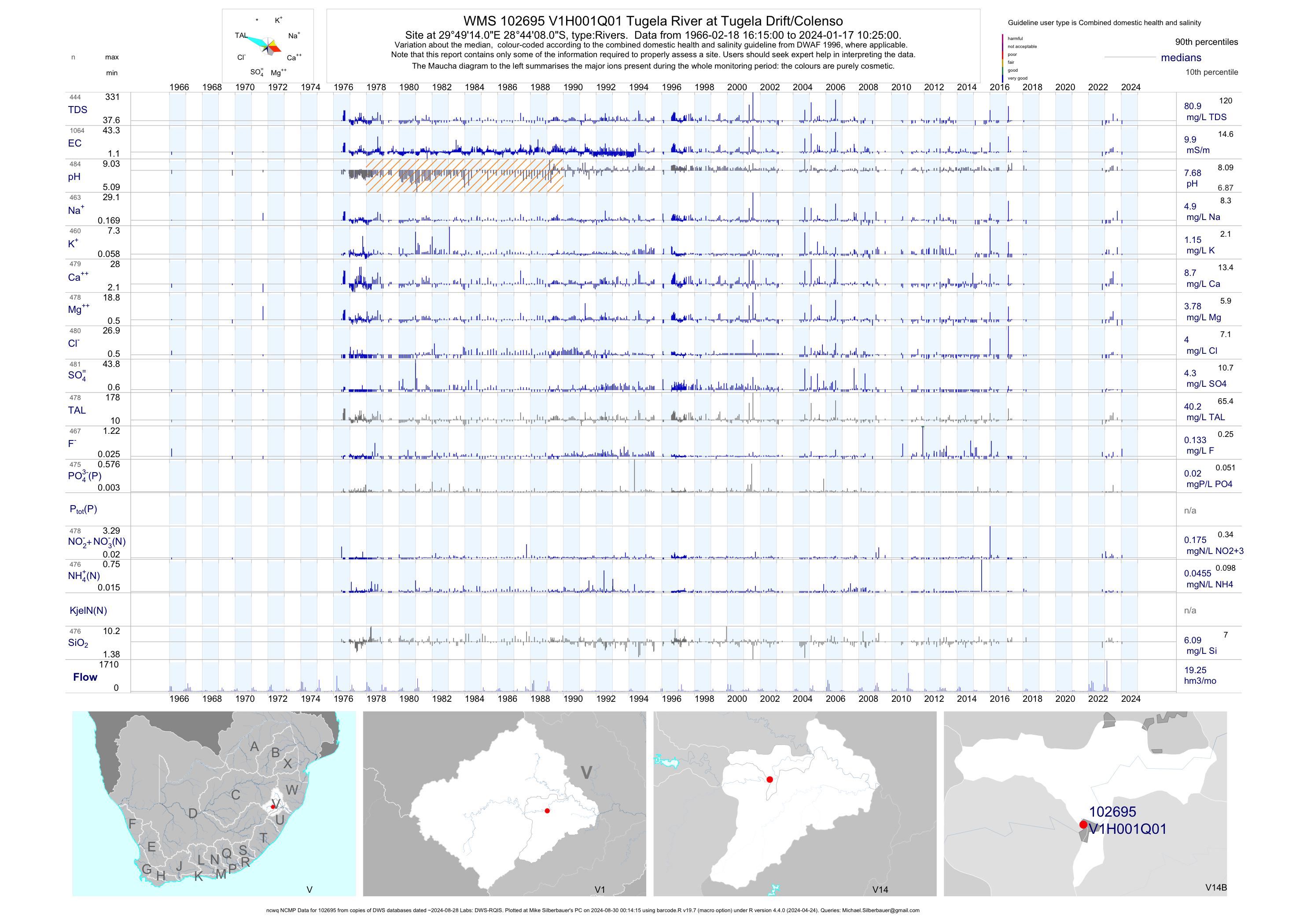
| V14 102695 | plot | data | Tugela River at Tugela Drift/Colenso (ncwq NCMP) | Rivers | 3491 | 1952-10-19 | 2018-03-14 | 10 | V1H001 | -28.73556 | 29.82056 |
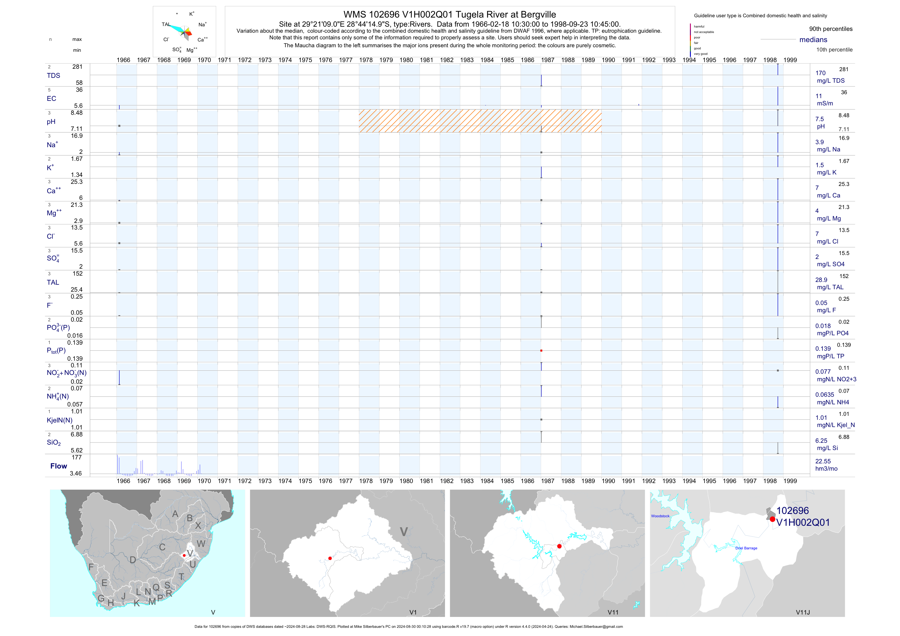
| V11 102696 | plot | data | Tugela River at Bergville | Rivers | 5 | 1966-02-18 | 1998-09-23 | 11 | V1H002 | -28.73750 | 29.35250 |
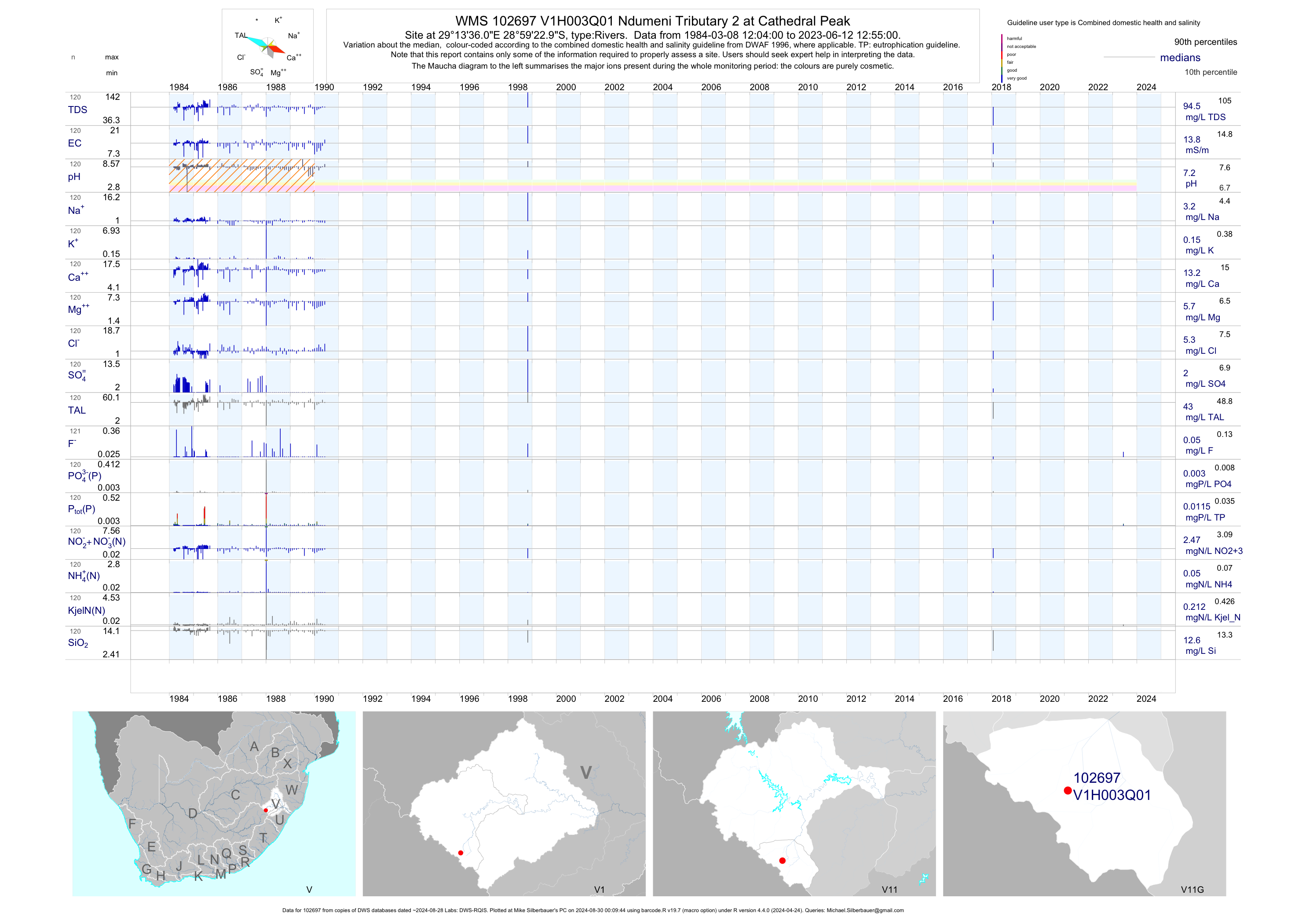
| V11 102697 | plot | data | Ndumeni Tributary 2 at Cathedral Peak | Rivers | 120 | 1984-03-08 | 2018-01-24 | 14 | V1H003 | -28.98972 | 29.22667 |
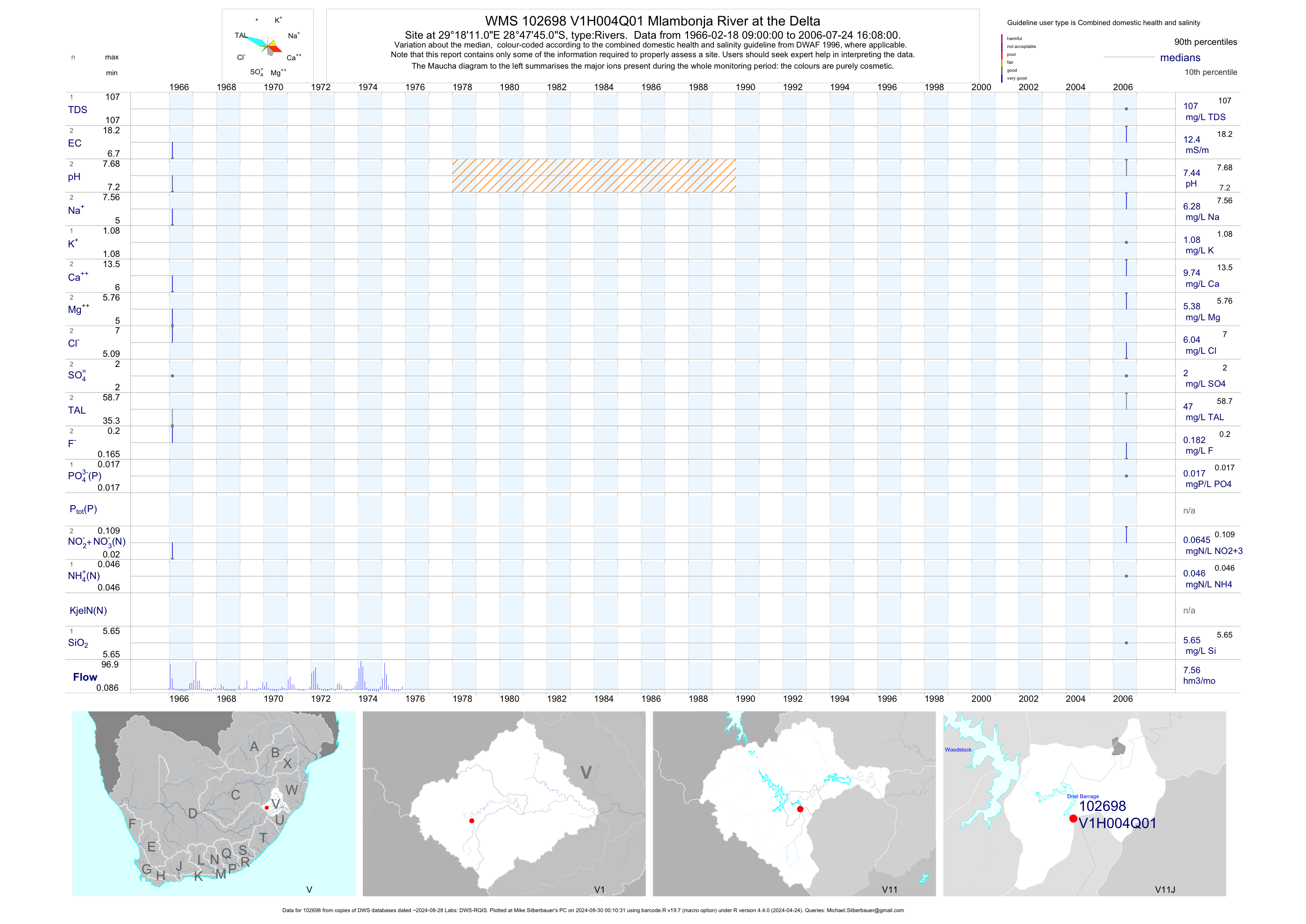
| V11 102698 | plot | data | Mlambonja River at the Delta | Rivers | 2 | 1966-02-18 | 2006-07-24 | 12 | V1H004 | -28.79583 | 29.30306 |
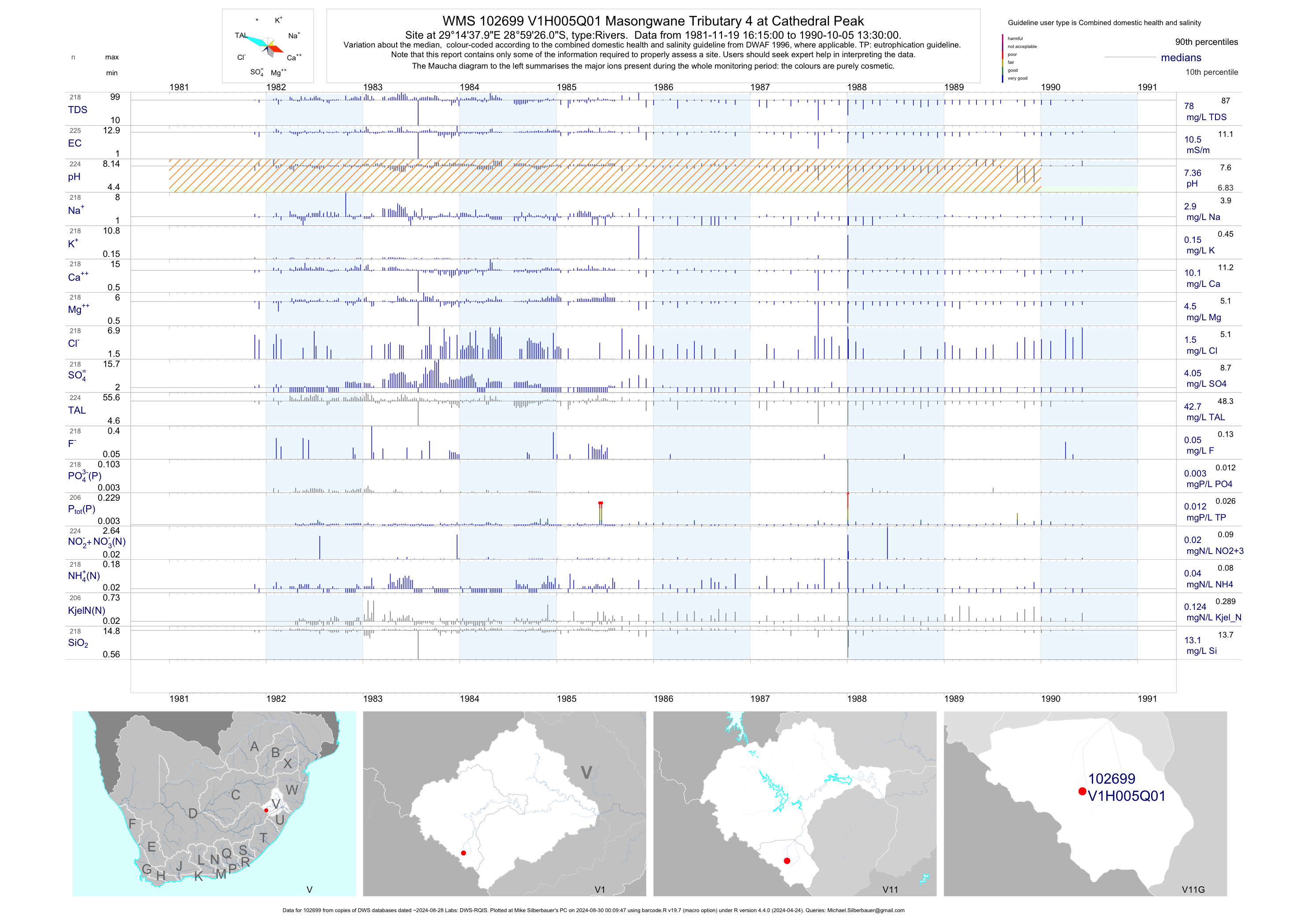
| V11 102699 | plot | data | Masongwane Tributary 4 at Cathedral Peak | Rivers | 225 | 1981-11-19 | 1990-10-05 | 10 | V1H005 | -28.99056 | 29.24389 |
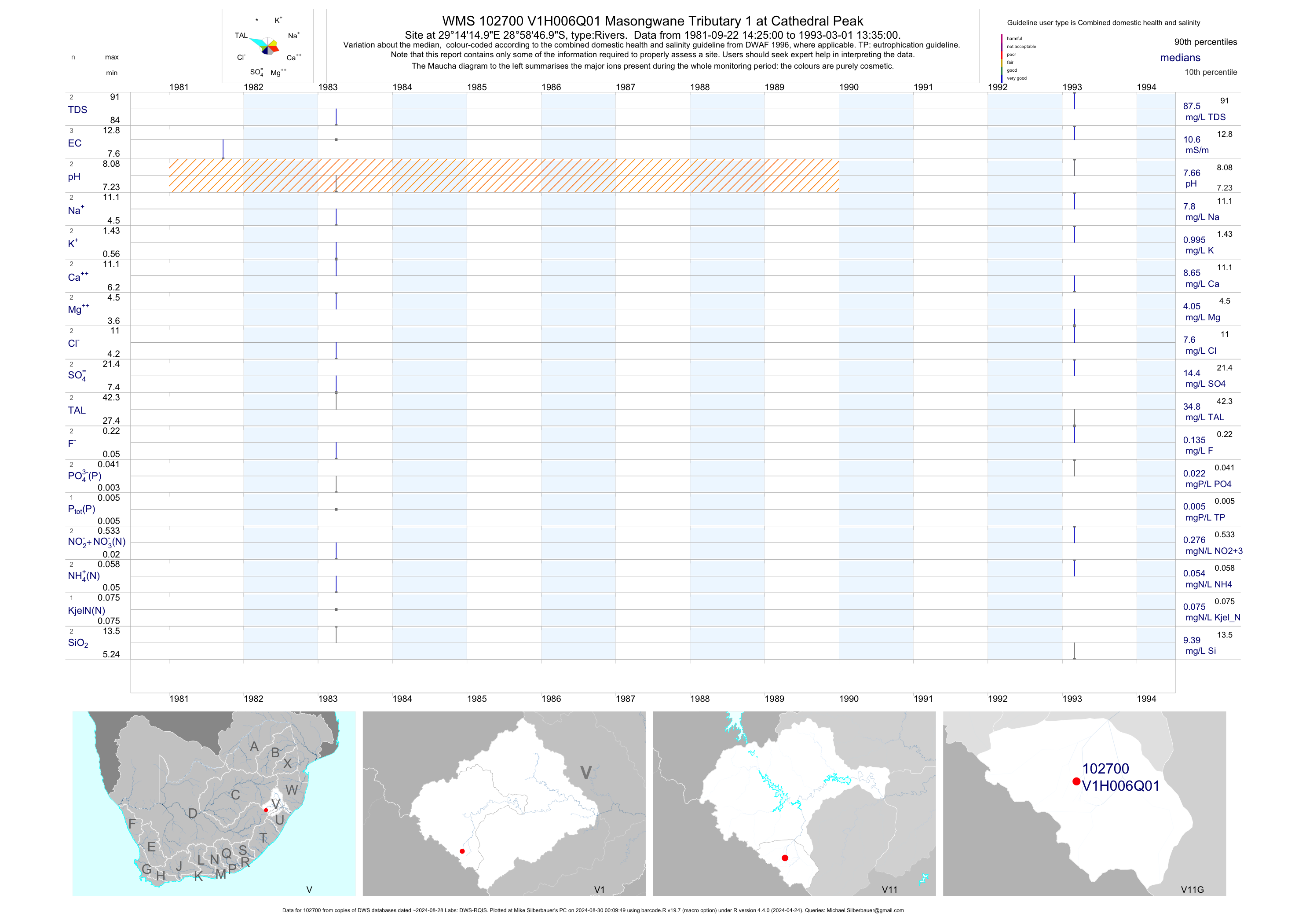
| V11 102700 | plot | data | Masongwane Tributary 1 at Cathedral Peak | Rivers | 3 | 1981-09-22 | 1993-03-01 | 11 | V1H006 | -28.97972 | 29.23750 |
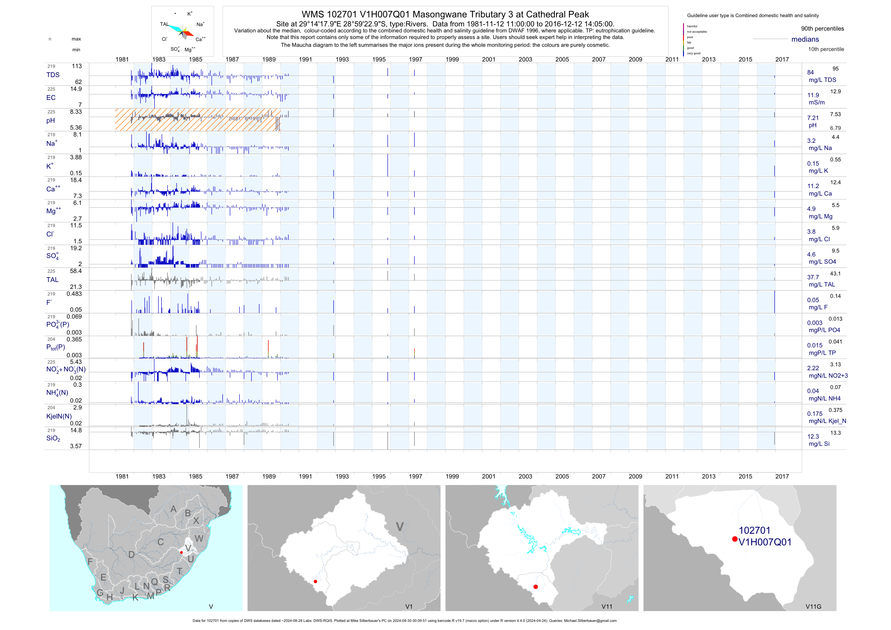
| V11 102701 | plot | data | Masongwane Tributary 3 at Cathedral Peak | Rivers | 225 | 1981-11-12 | 2016-12-12 | 12 | V1H007 | -28.98972 | 29.23833 |
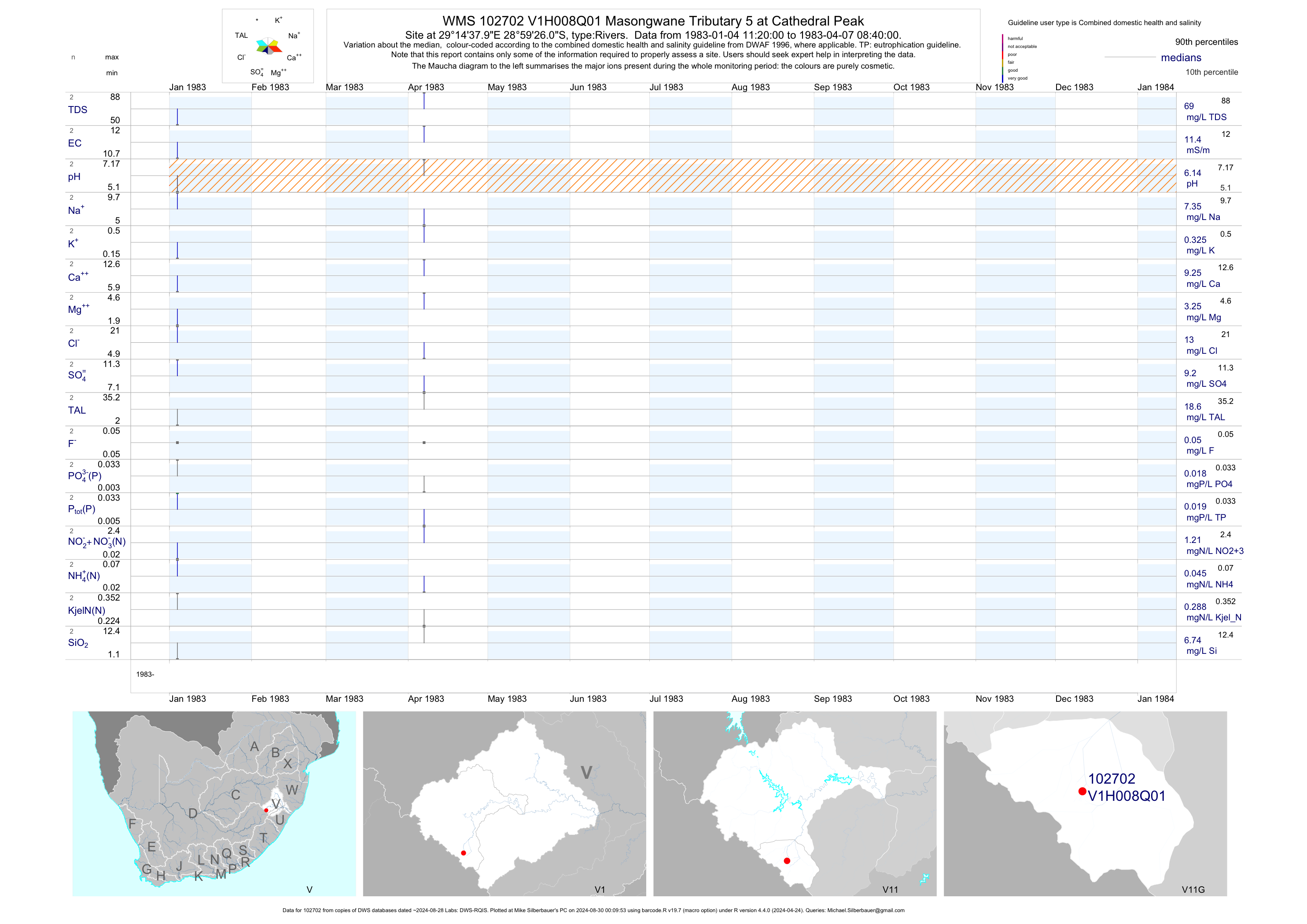
| V11 102702 | plot | data | Masongwane Tributary 5 at Cathedral Peak | Rivers | 2 | 1983-01-04 | 1983-04-07 | 11 | V1H008 | -28.99056 | 29.24389 |
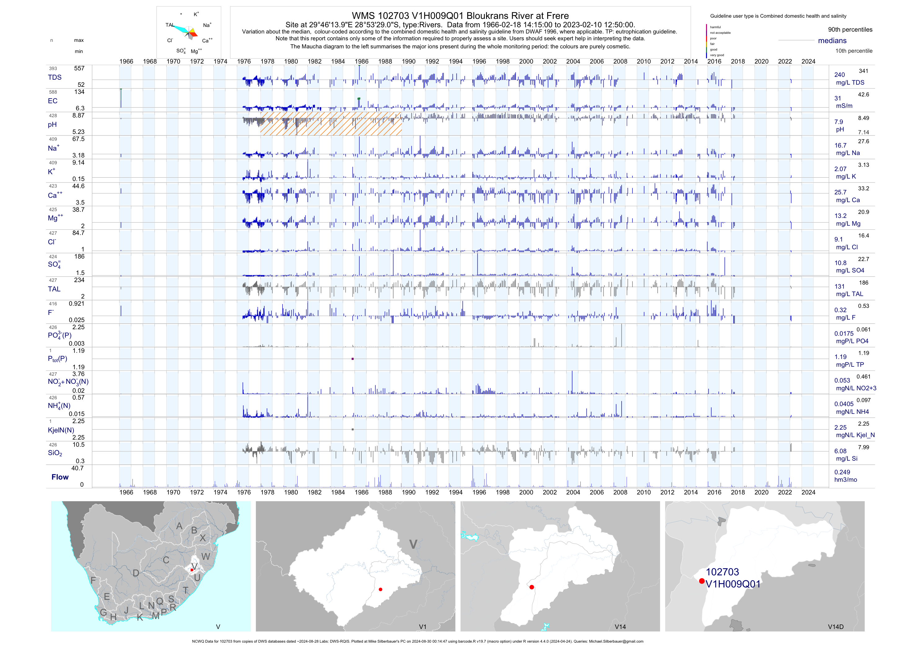
| V14 102703 | plot | data | Bloukrans River at Frere (NCWQ) | Rivers | 588 | 1966-02-18 | 2018-04-16 | 31 | V1H009 | -28.89139 | 29.77056 |
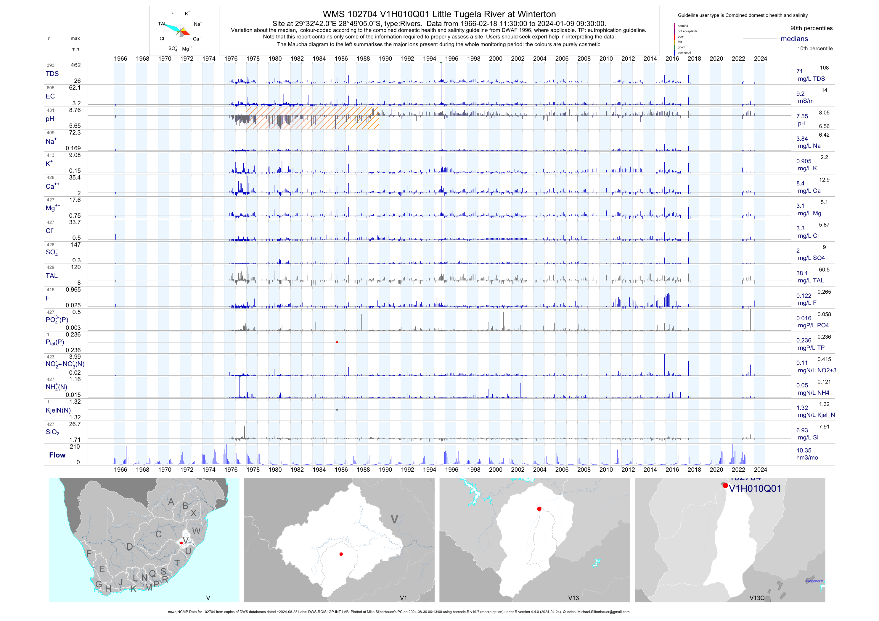
| V13 102704 | plot | data | Little Tugela River at Winterton (ncwq NCMP) | Rivers | 599 | 1966-02-18 | 2018-04-16 | 9 | V1H010 | -28.81806 | 29.54500 |
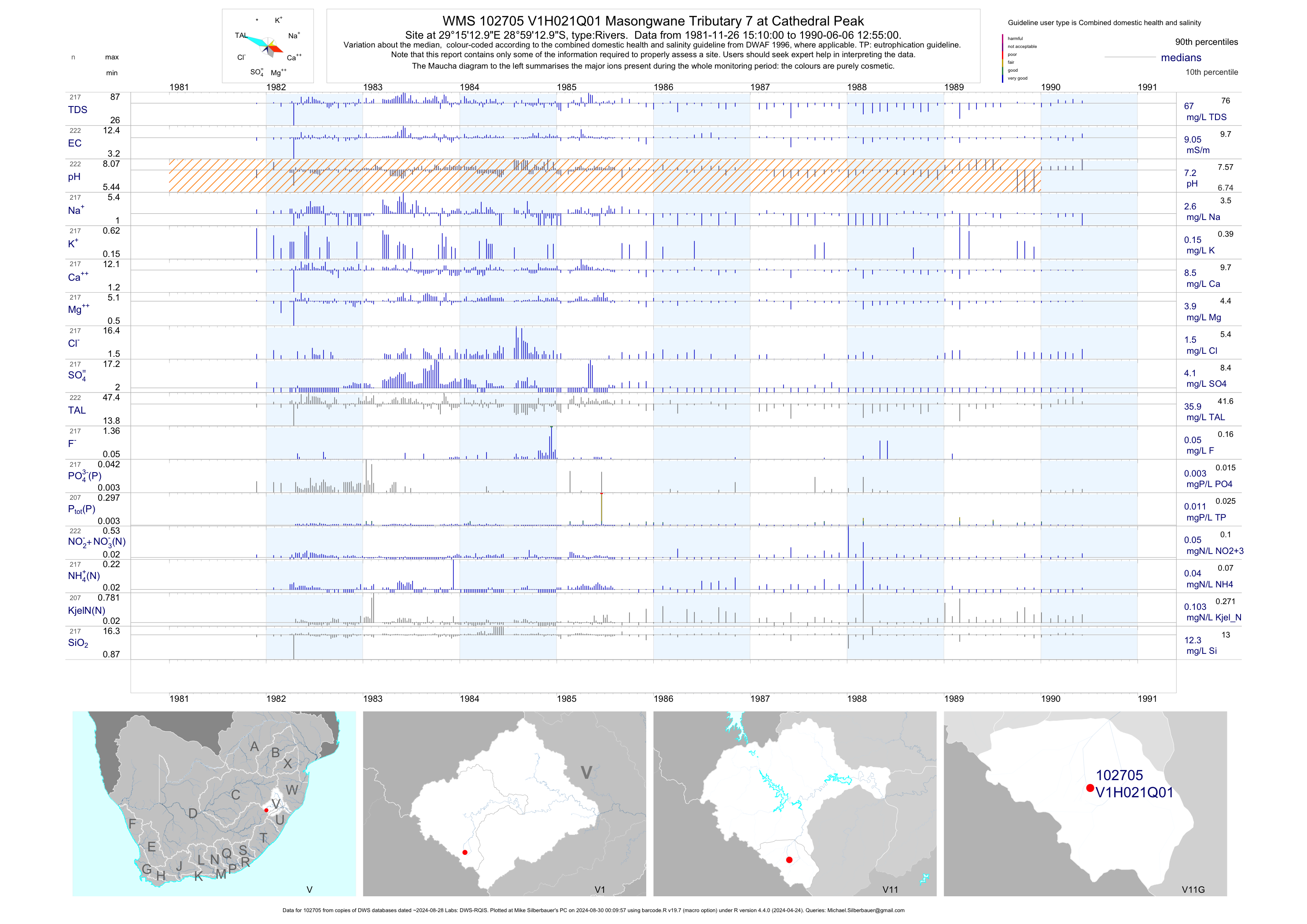
| V11 102705 | plot | data | Masongwane Tributary 7 at Cathedral Peak | Rivers | 222 | 1981-11-26 | 1990-06-06 | 9 | V1H021 | -28.98694 | 29.25361 |
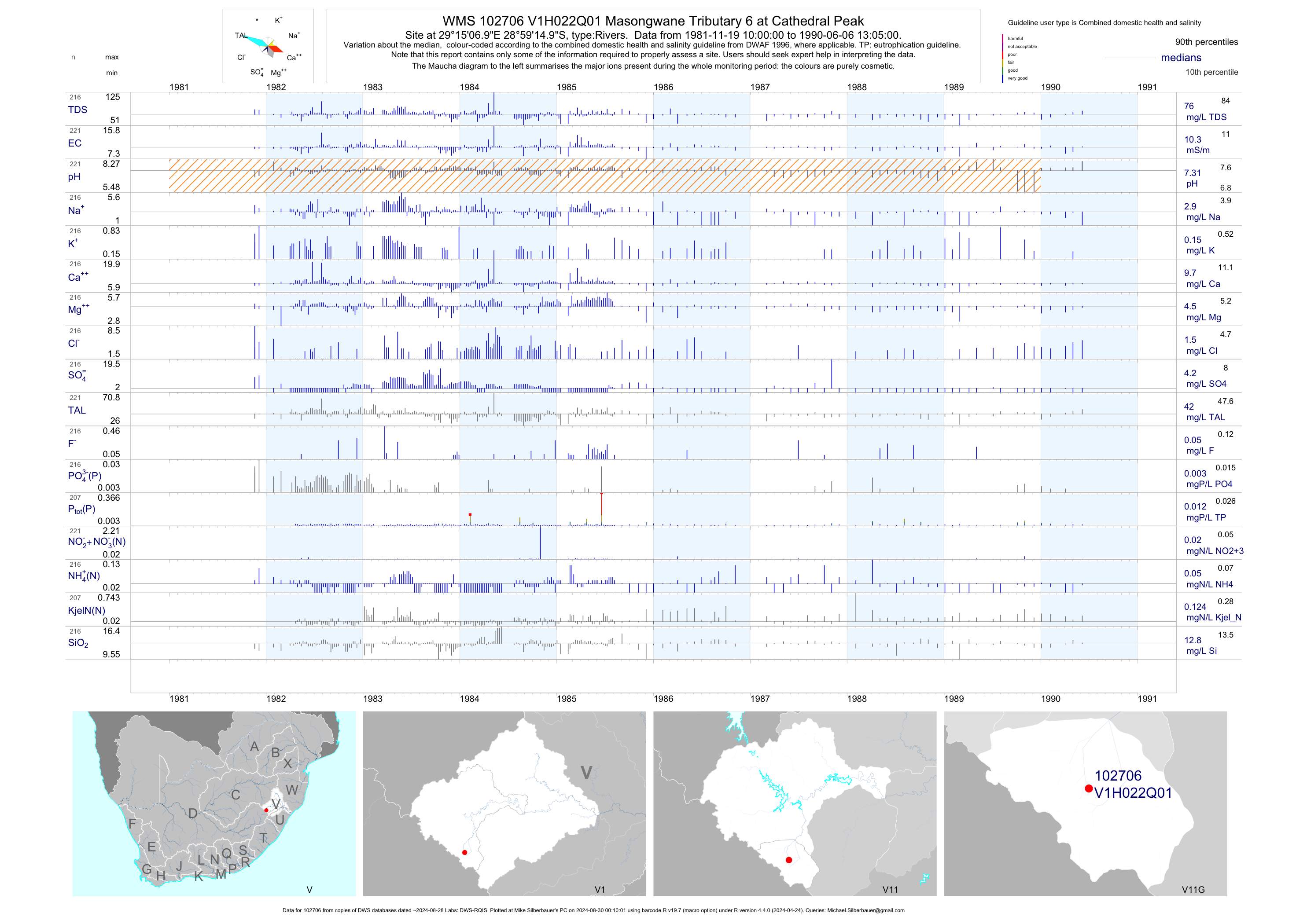
| V11 102706 | plot | data | Masongwane Tributary 6 at Cathedral Peak | Rivers | 221 | 1981-11-19 | 1990-06-06 | 10 | V1H022 | -28.98750 | 29.25194 |
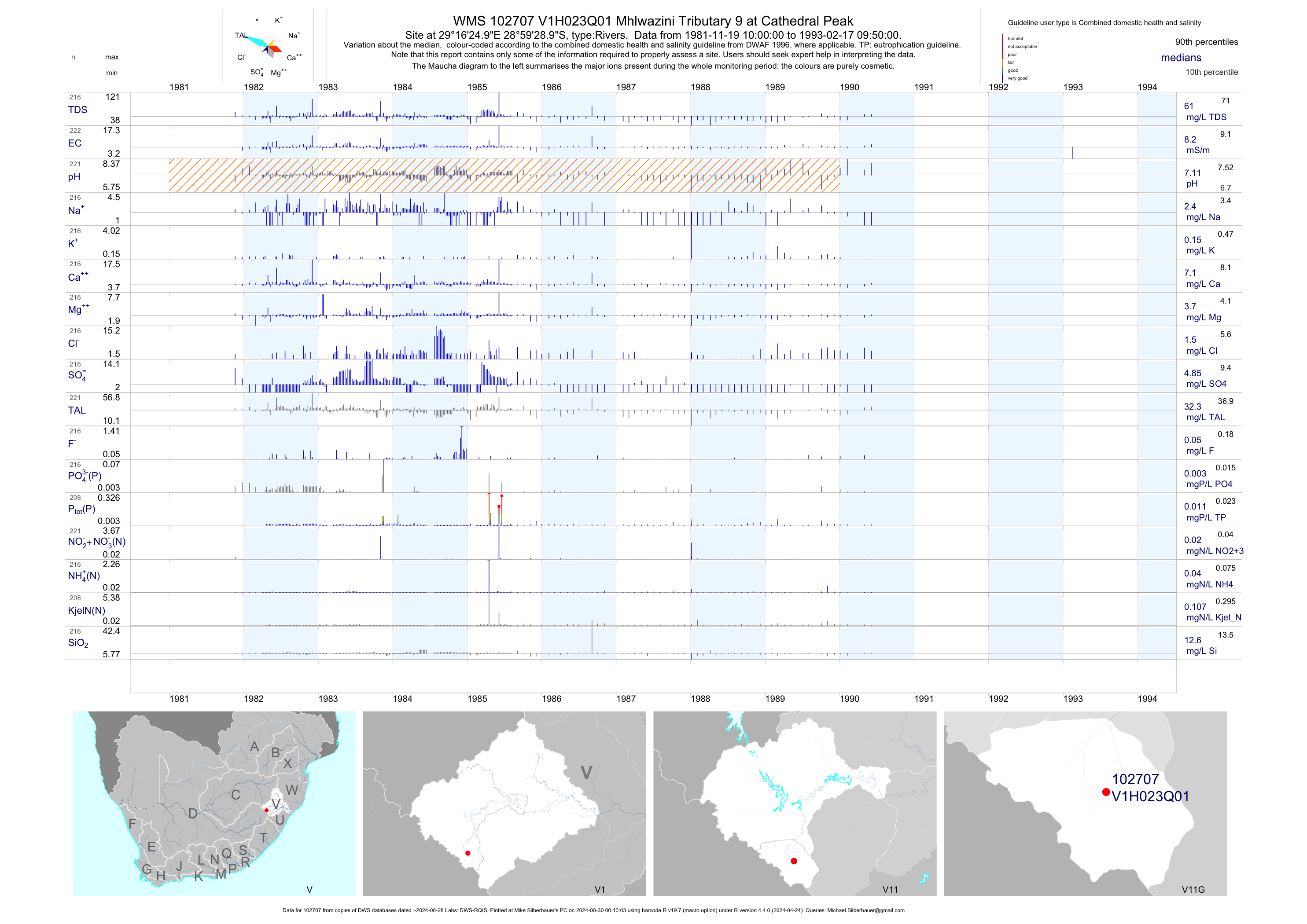
| V11 102707 | plot | data | Mhlwazini Tributary 9 at Cathedral Peak | Rivers | 222 | 1981-11-19 | 1993-02-17 | 8 | V1H023 | -28.99139 | 29.27361 |
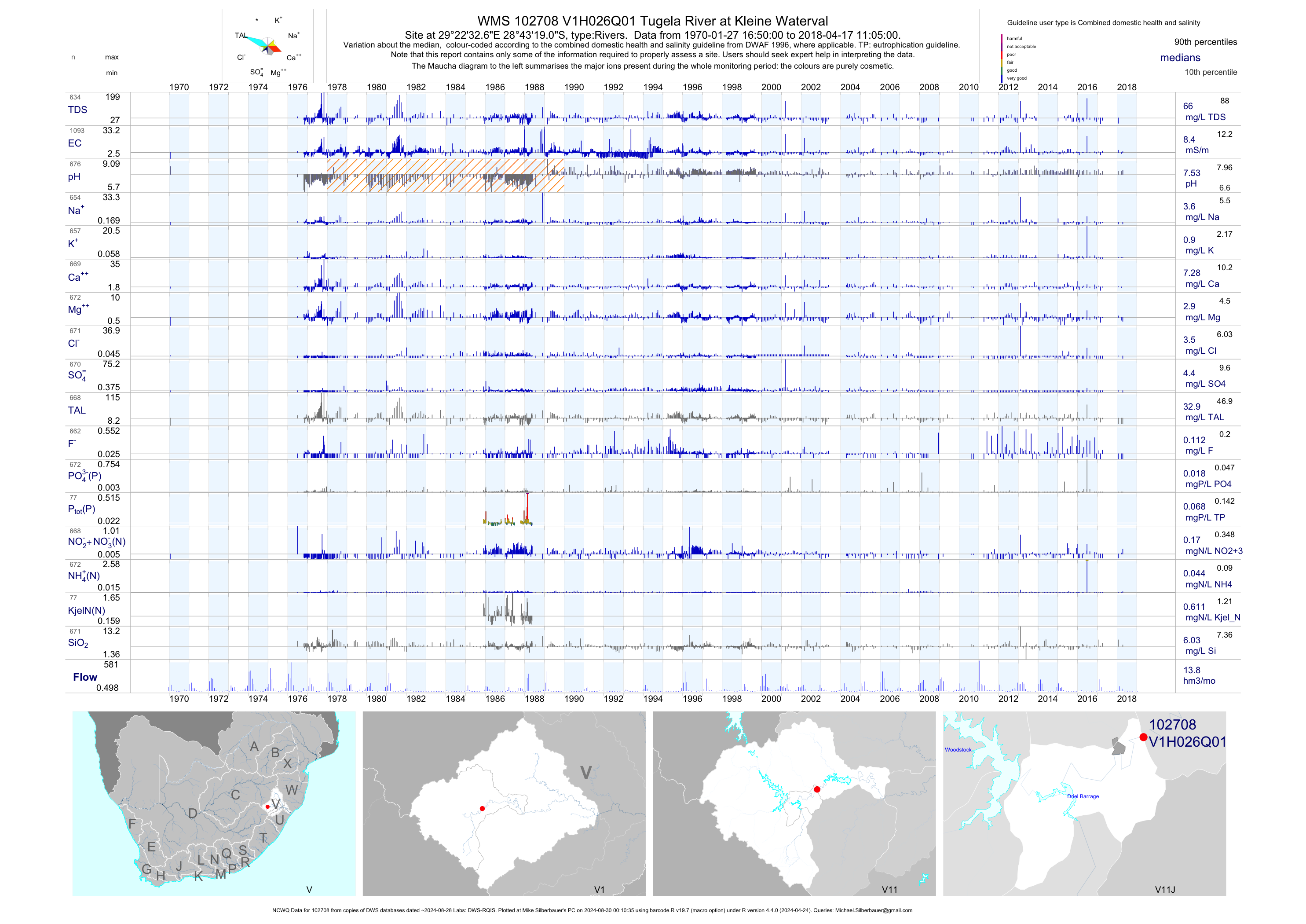
| V11 102708 | plot | data | Tugela River at Kleine Waterval (NCWQ) | Rivers | 1096 | 1970-01-27 | 2018-04-17 | 8 | V1H026 | -28.72194 | 29.37572 |
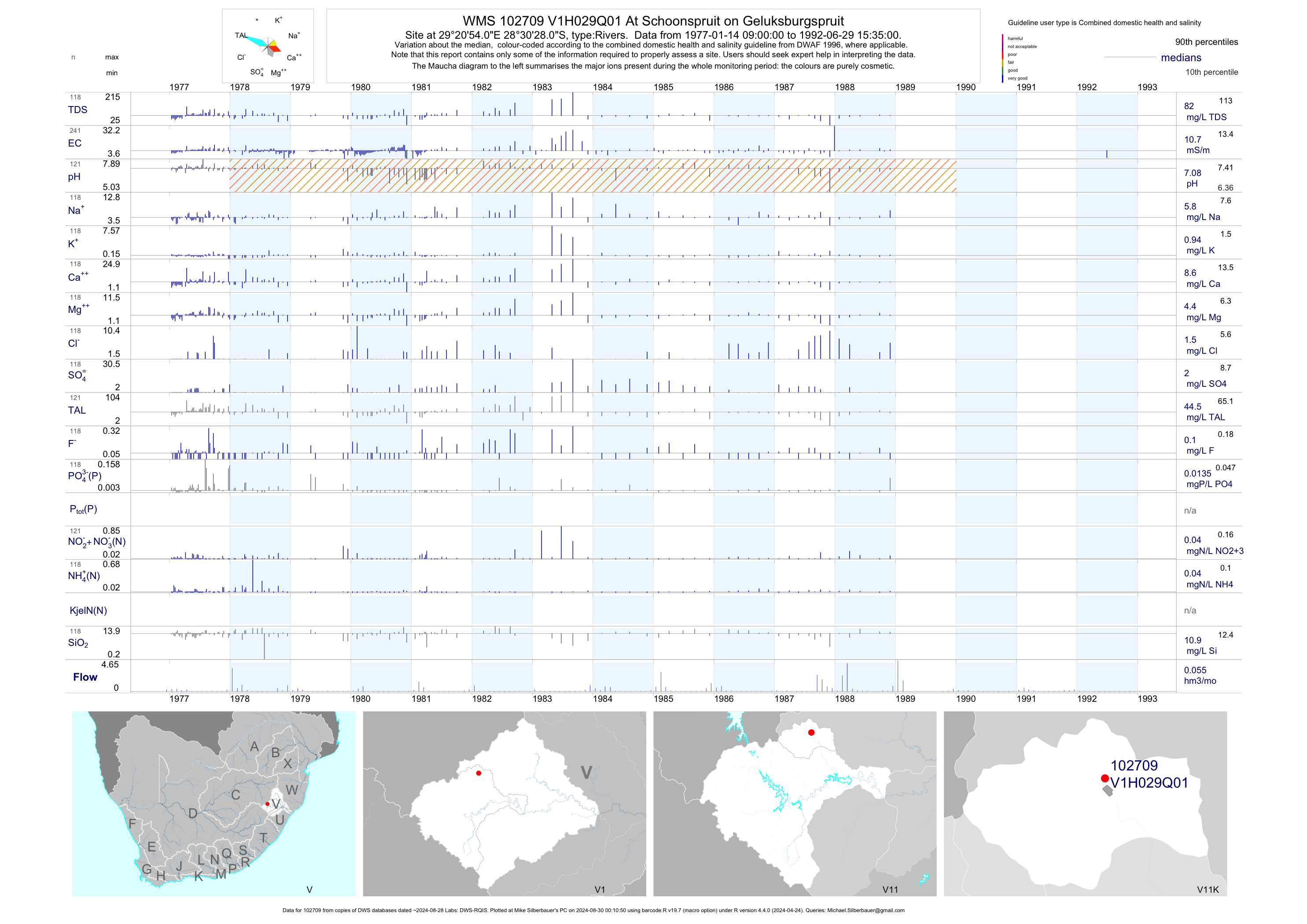
| V11 102709 | plot | data | At Schoonspruit on Geluksburgspruit | Rivers | 241 | 1977-01-14 | 1992-06-29 | 11 | V1H029 | -28.50778 | 29.34833 |
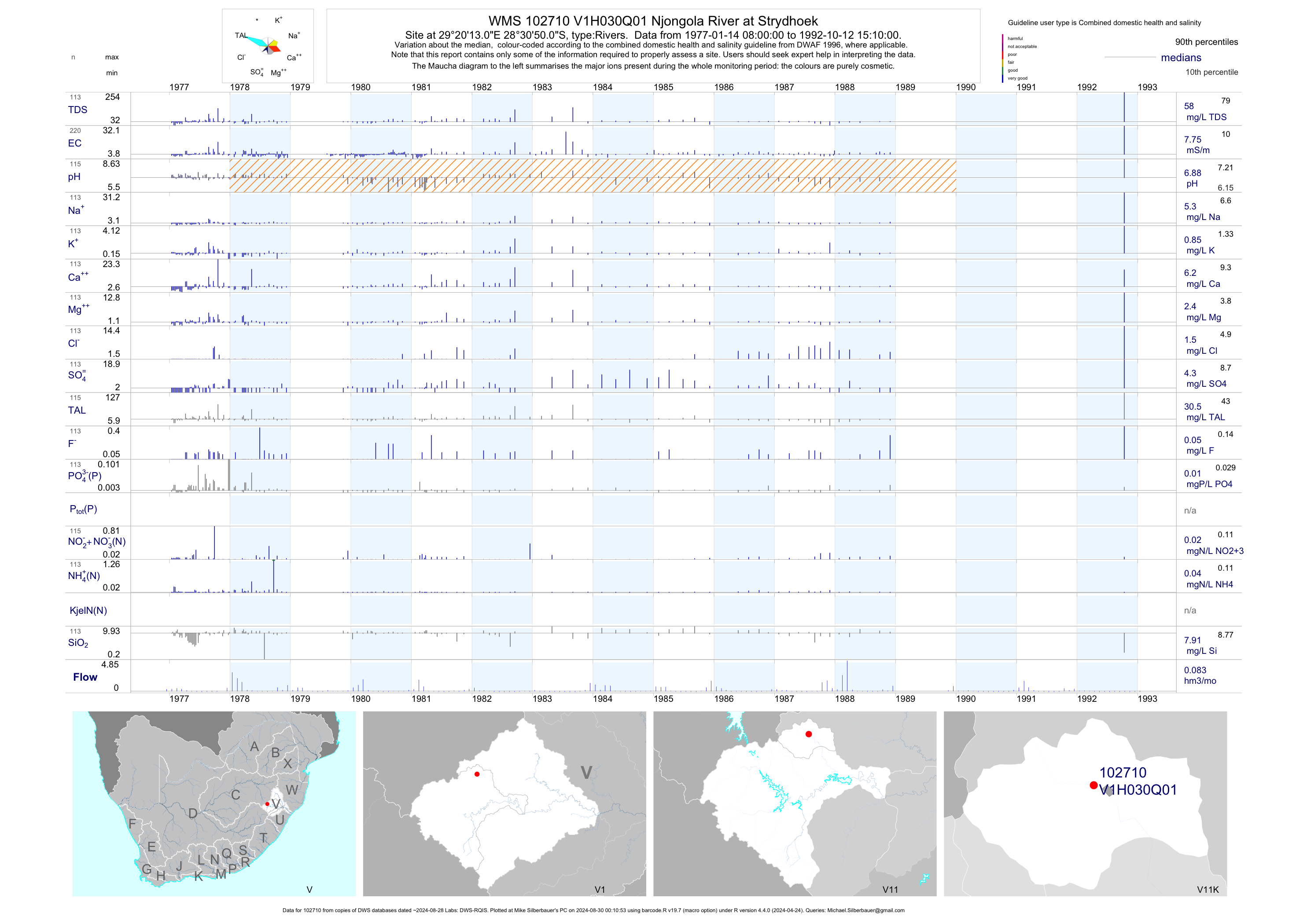
| V11 102710 | plot | data | Njongola River at Strydhoek | Rivers | 220 | 1977-01-14 | 1992-10-12 | 8 | V1H030 | -28.51389 | 29.33694 |
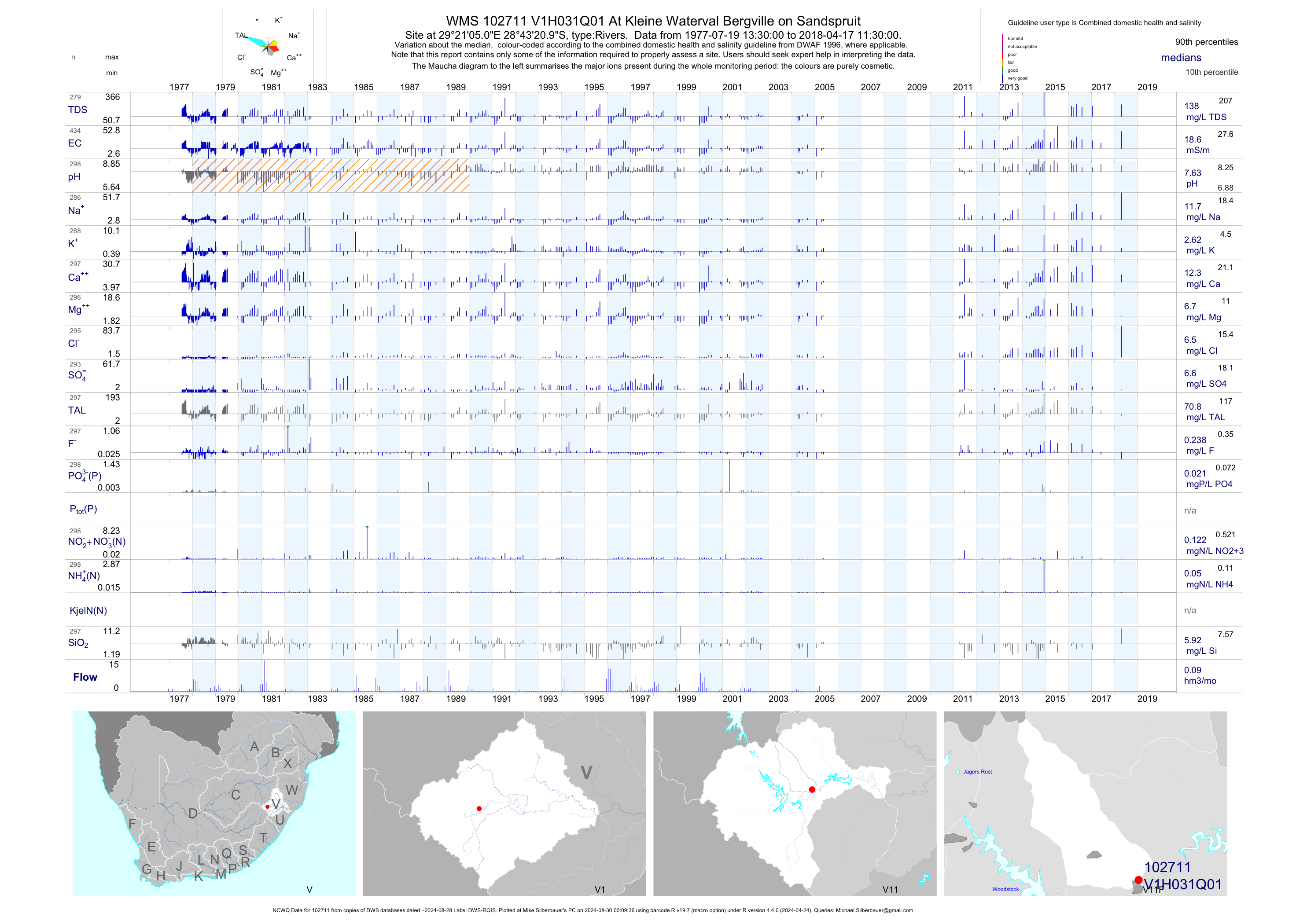
| V11 102711 | plot | data | At Kleine Waterval Bergville on Sandspruit (NCWQ) | Rivers | 436 | 1977-07-19 | 2018-04-17 | 19 | V1H031 | -28.72250 | 29.35139 |
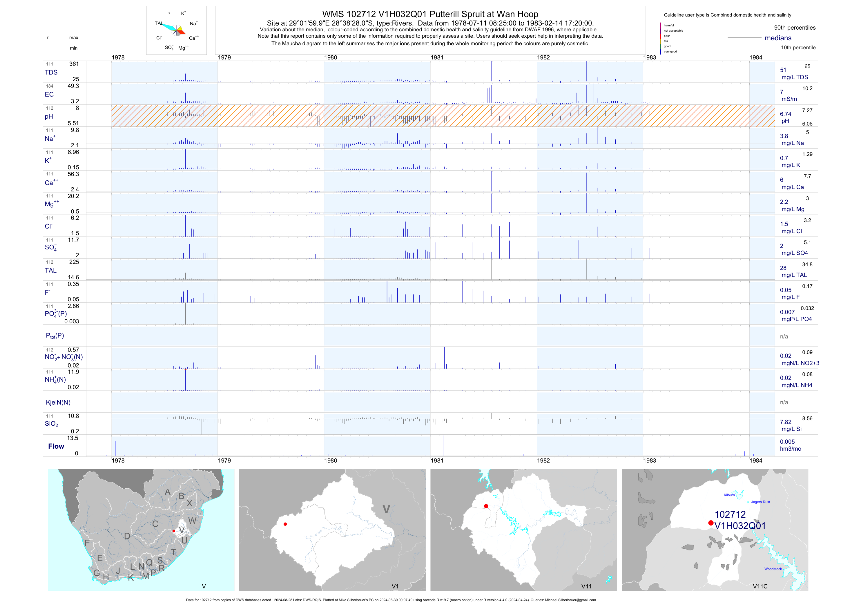
| V11 102712 | plot | data | Putterill Spruit at Wan Hoop | Rivers | 184 | 1978-07-11 | 1983-02-14 | 7 | V1H032 | -28.64111 | 29.03333 |
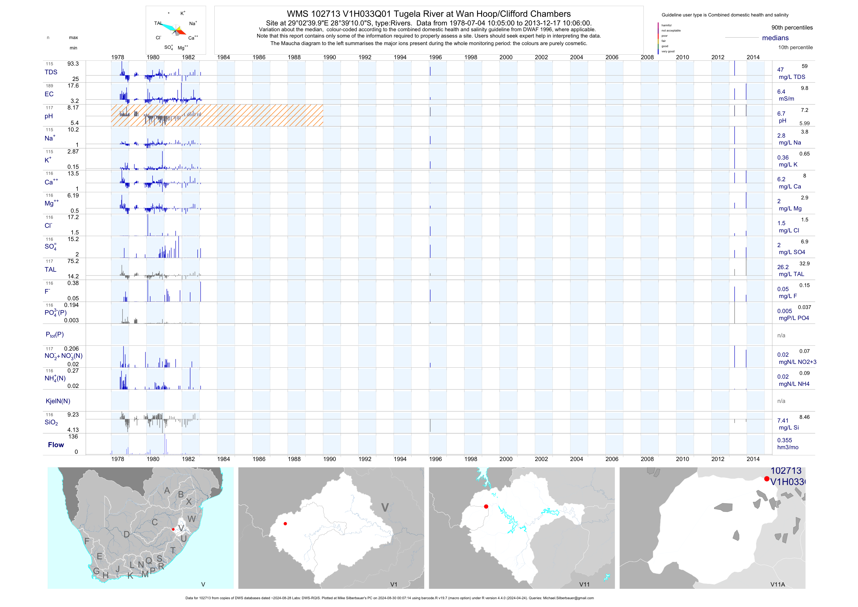
| V11 102713 | plot | data | Tugela River at Wan Hoop/Clifford Chambers | Rivers | 189 | 1978-07-04 | 2013-12-17 | 6 | V1H033 | -28.65278 | 29.04444 |
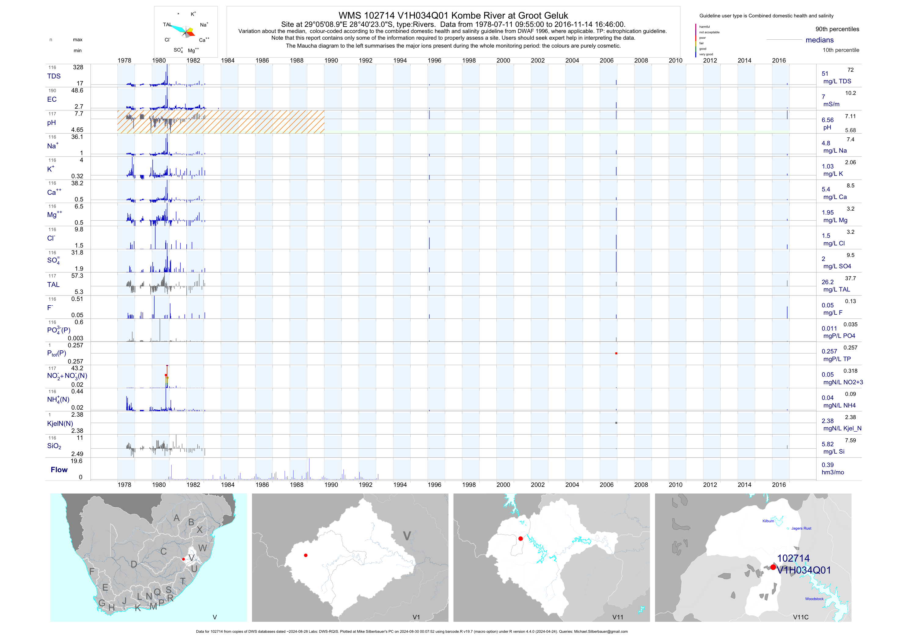
| V11 102714 | plot | data | Kombe River at Groot Geluk | Rivers | 190 | 1978-07-11 | 2016-11-14 | 7 | V1H034 | -28.67306 | 29.08583 |
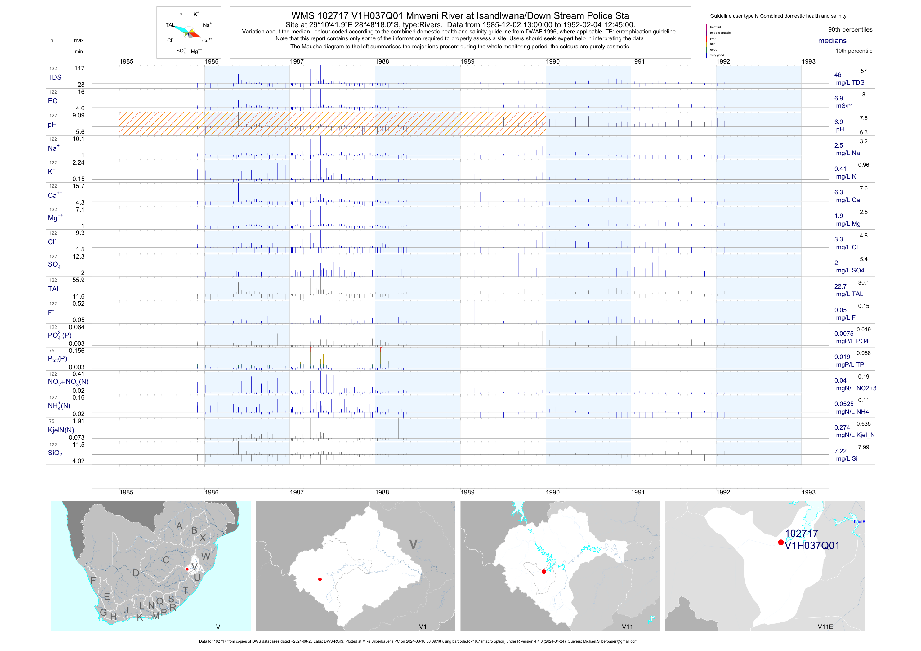
| V11 102717 | plot | data | Mnweni River at Isandlwana/Down Stream Police Sta | Rivers | 123 | 1985-12-02 | 1992-02-04 | 7 | V1H037 | -28.80500 | 29.17833 |
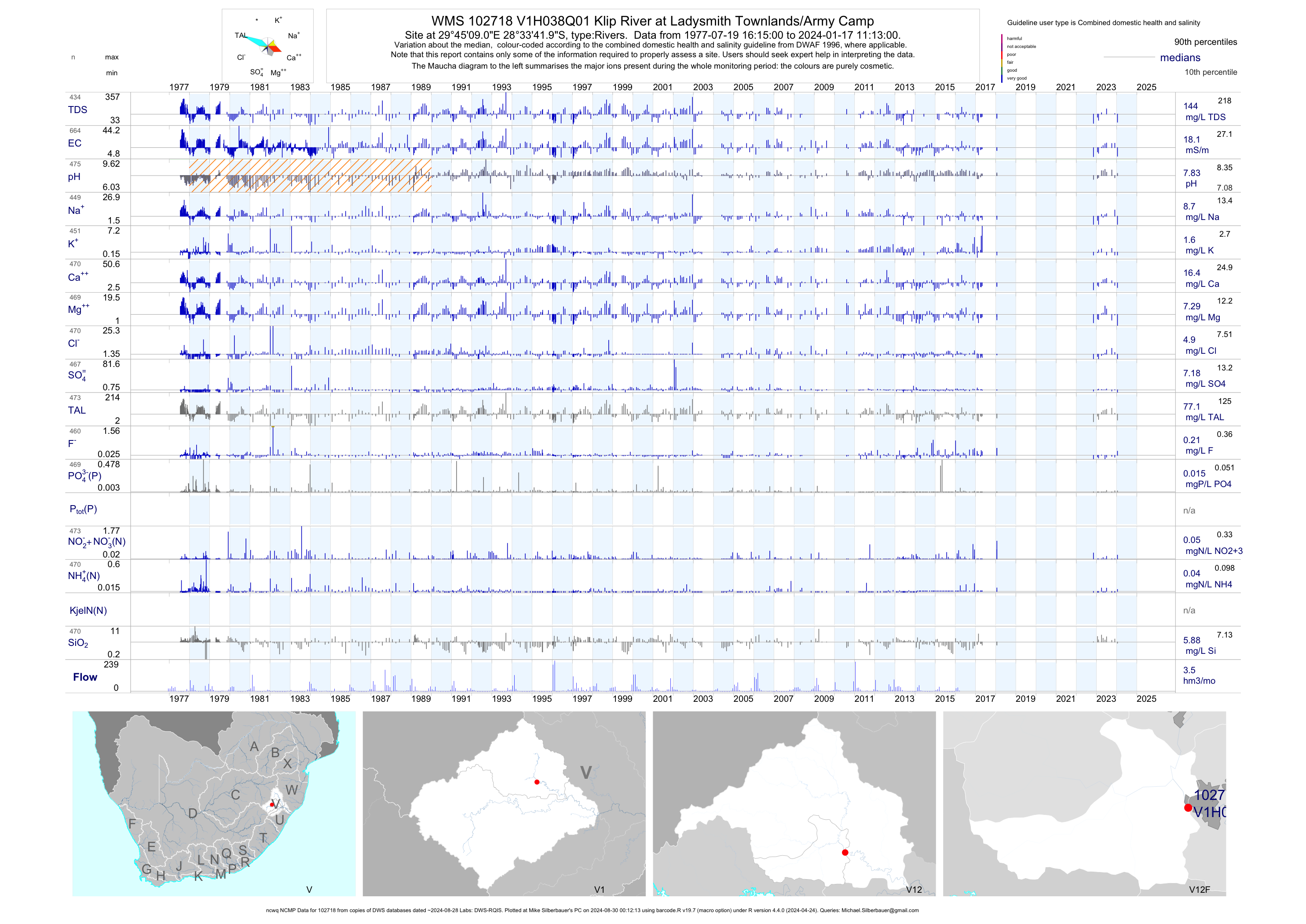
| V12 102718 | plot | data | Klip River at Ladysmith Townlands/Army Camp (ncwq NCMP) | Rivers | 702 | 1977-07-19 | 2018-08-25 | 18 | V1H038 | -28.56167 | 29.75250 |
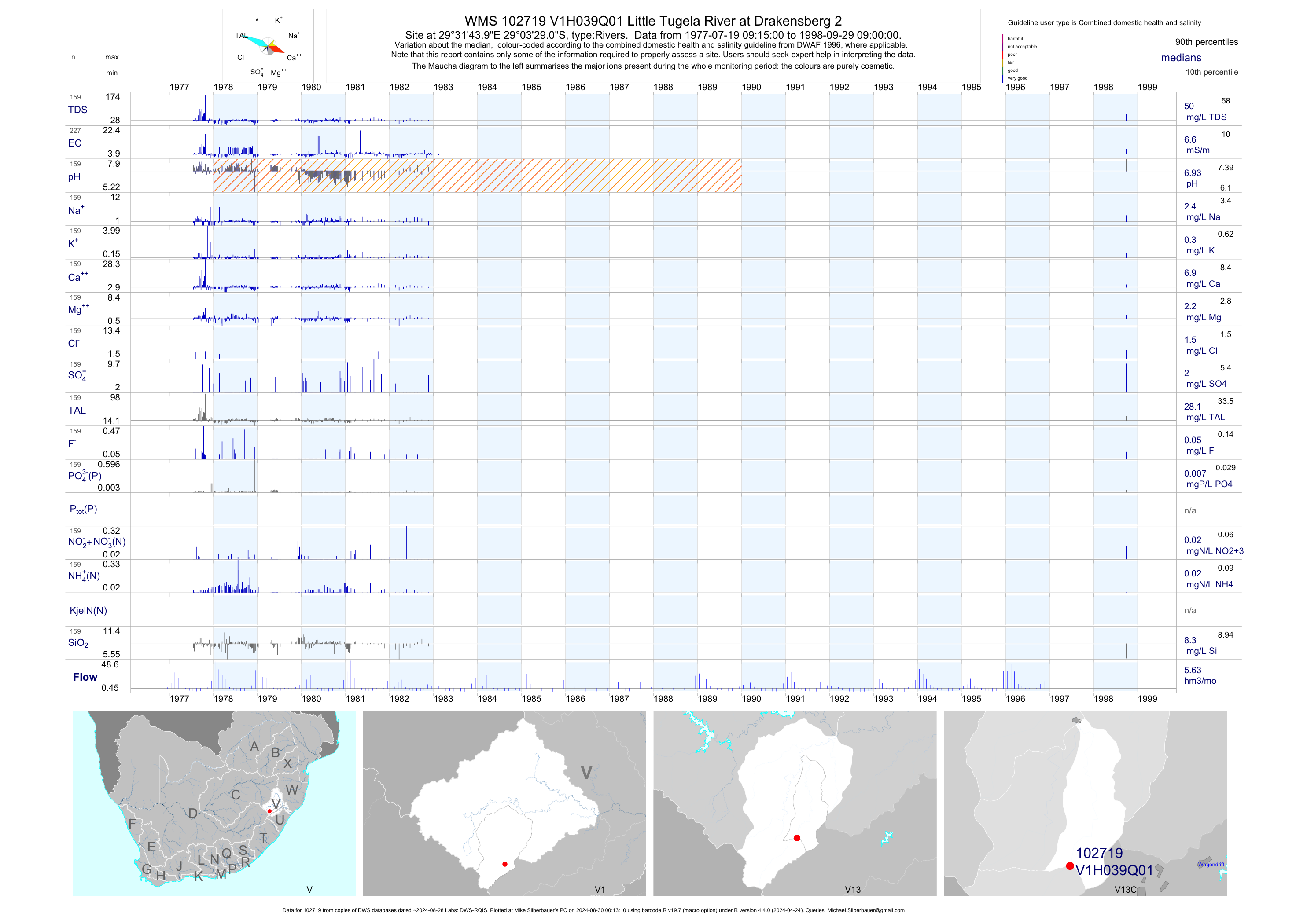
| V13 102719 | plot | data | Little Tugela River at Drakensberg 2 | Rivers | 227 | 1977-07-19 | 1998-09-29 | 7 | V1H039 | -29.05806 | 29.52889 |
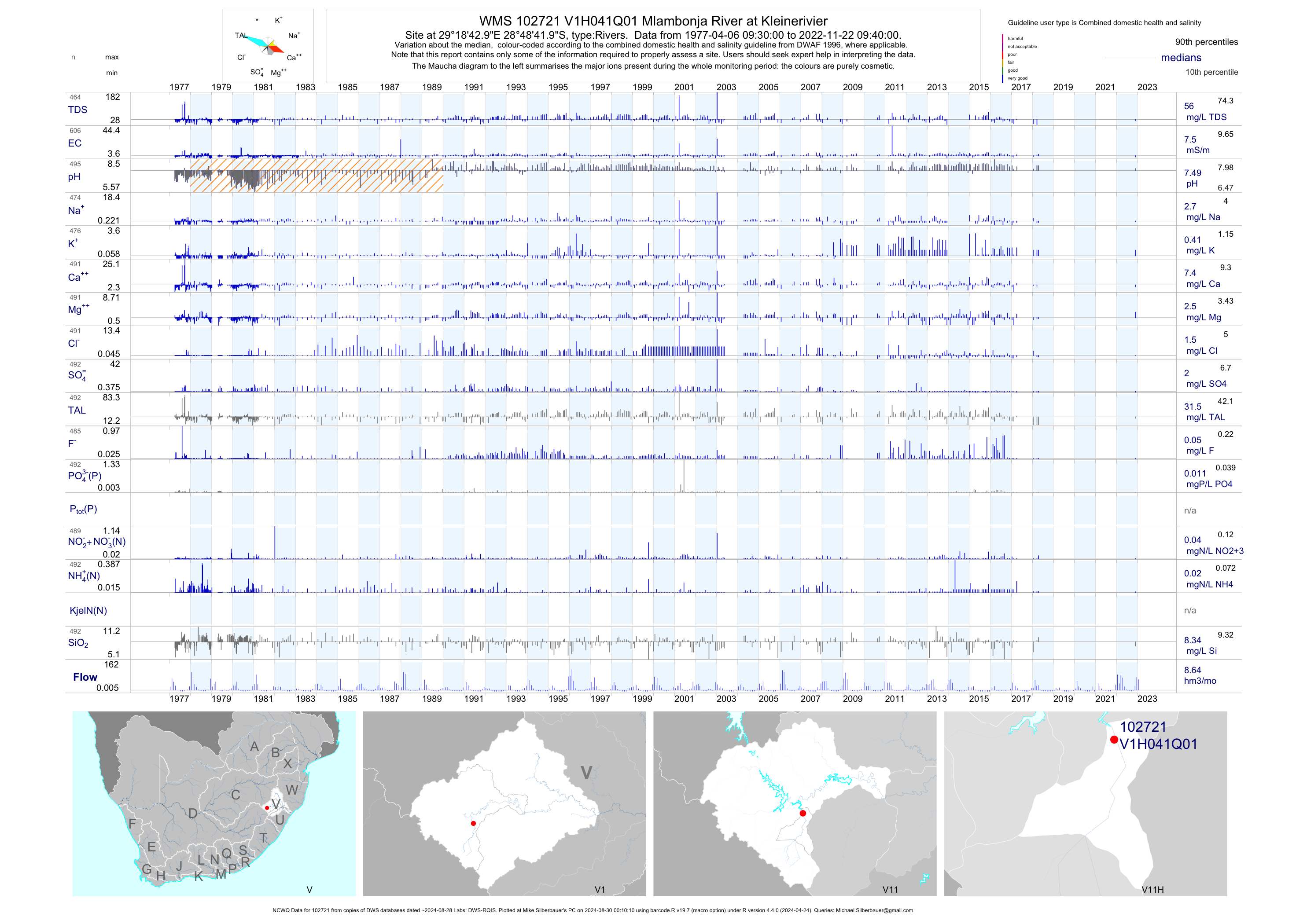
| V11 102721 | plot | data | Mlambonja River at Kleinerivier (NCWQ) | Rivers | 608 | 1977-04-06 | 2018-04-17 | 8 | V1H041 | -28.81167 | 29.31194 |
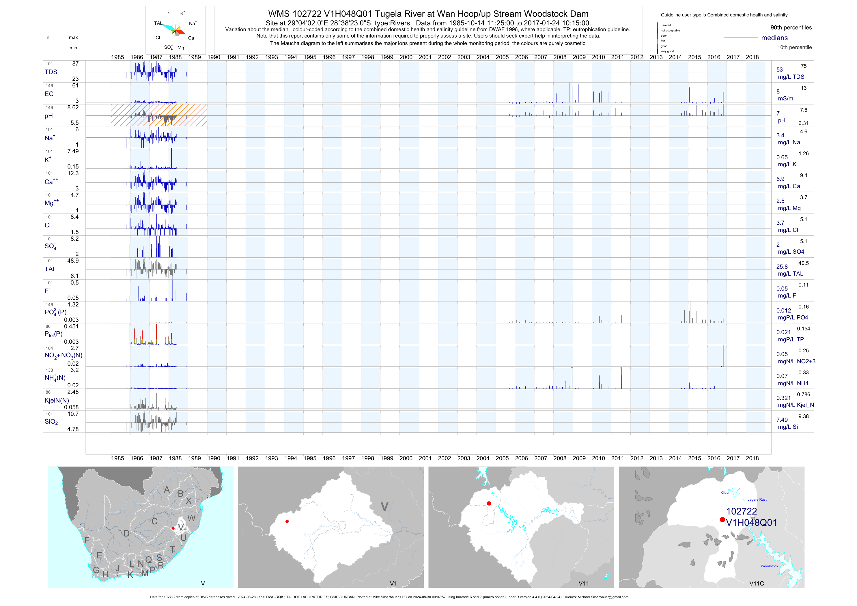
| V11 102722 | plot | data | Tugela River at Wan Hoop/up Stream Woodstock Dam | Rivers | 164 | 1985-10-14 | 2017-02-28 | 8 | V1H048 | -28.63972 | 29.06722 |
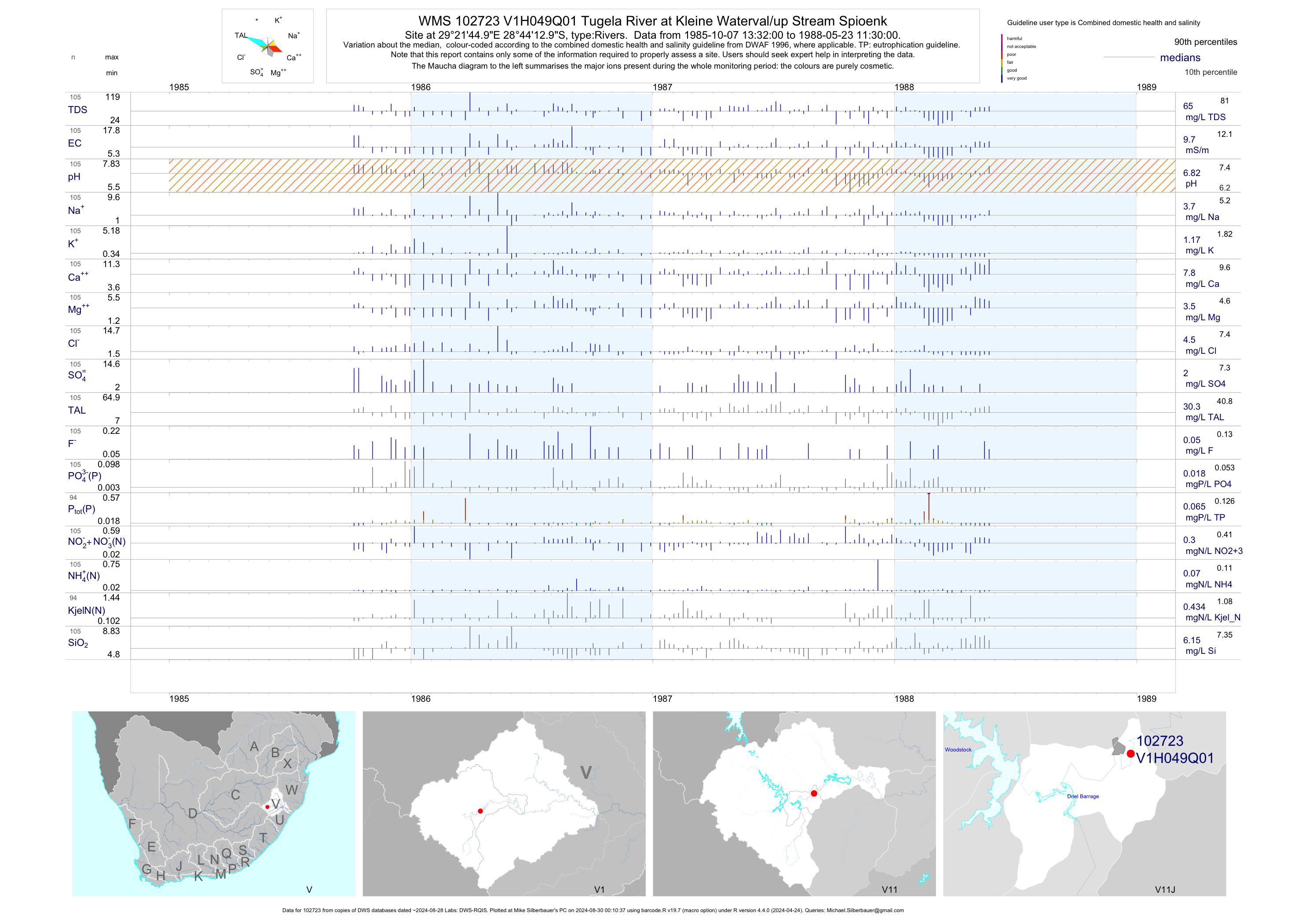
| V11 102723 | plot | data | Tugela River at Kleine Waterval/up Stream Spioenk | Rivers | 105 | 1985-10-07 | 1988-05-23 | 10 | V1H049 | -28.73694 | 29.36250 |
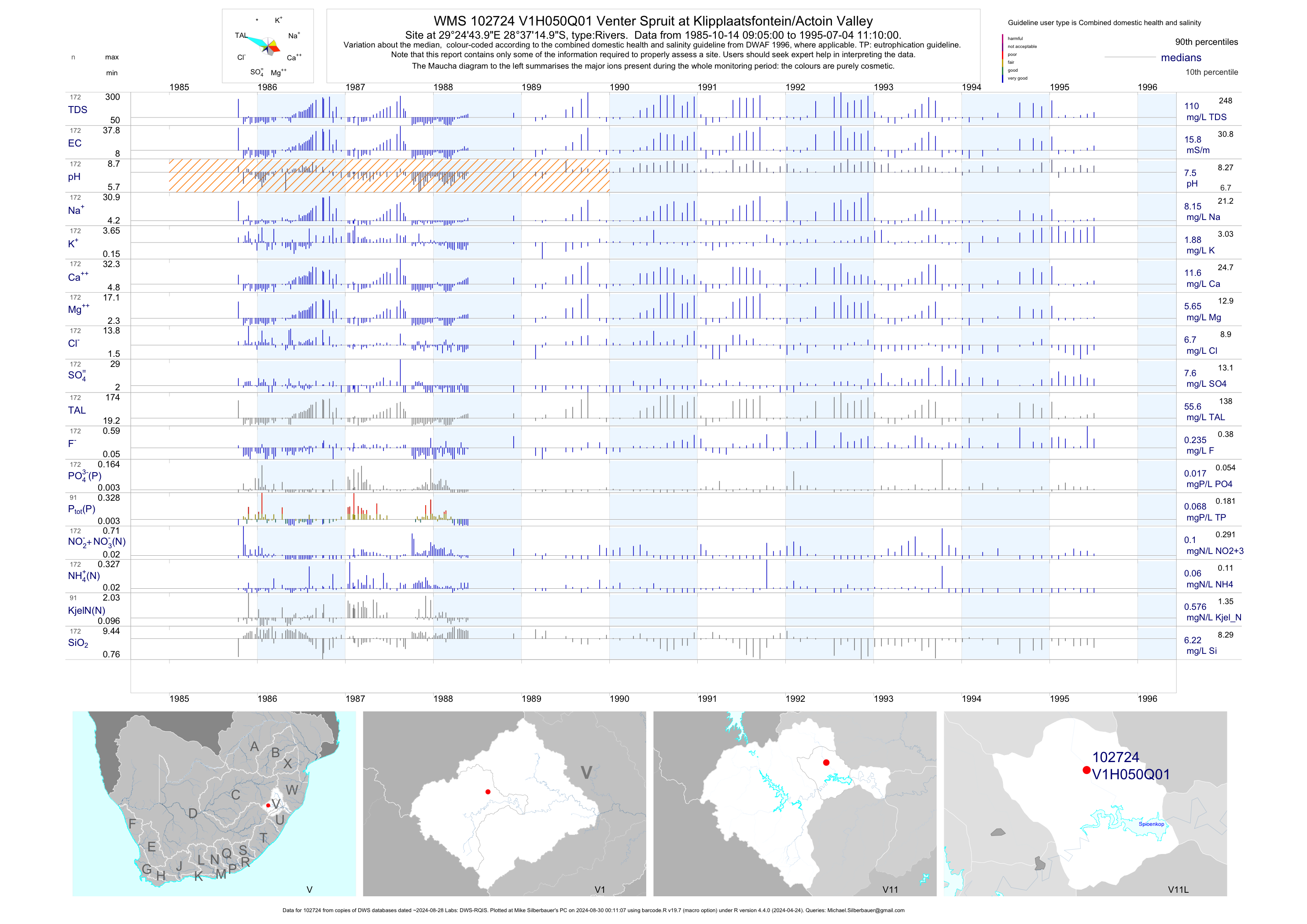
| V11 102724 | plot | data | Venter Spruit at Klipplaatsfontein/Actoin Valley | Rivers | 172 | 1985-10-14 | 1995-07-04 | 16 | V1H050 | -28.62083 | 29.41222 |
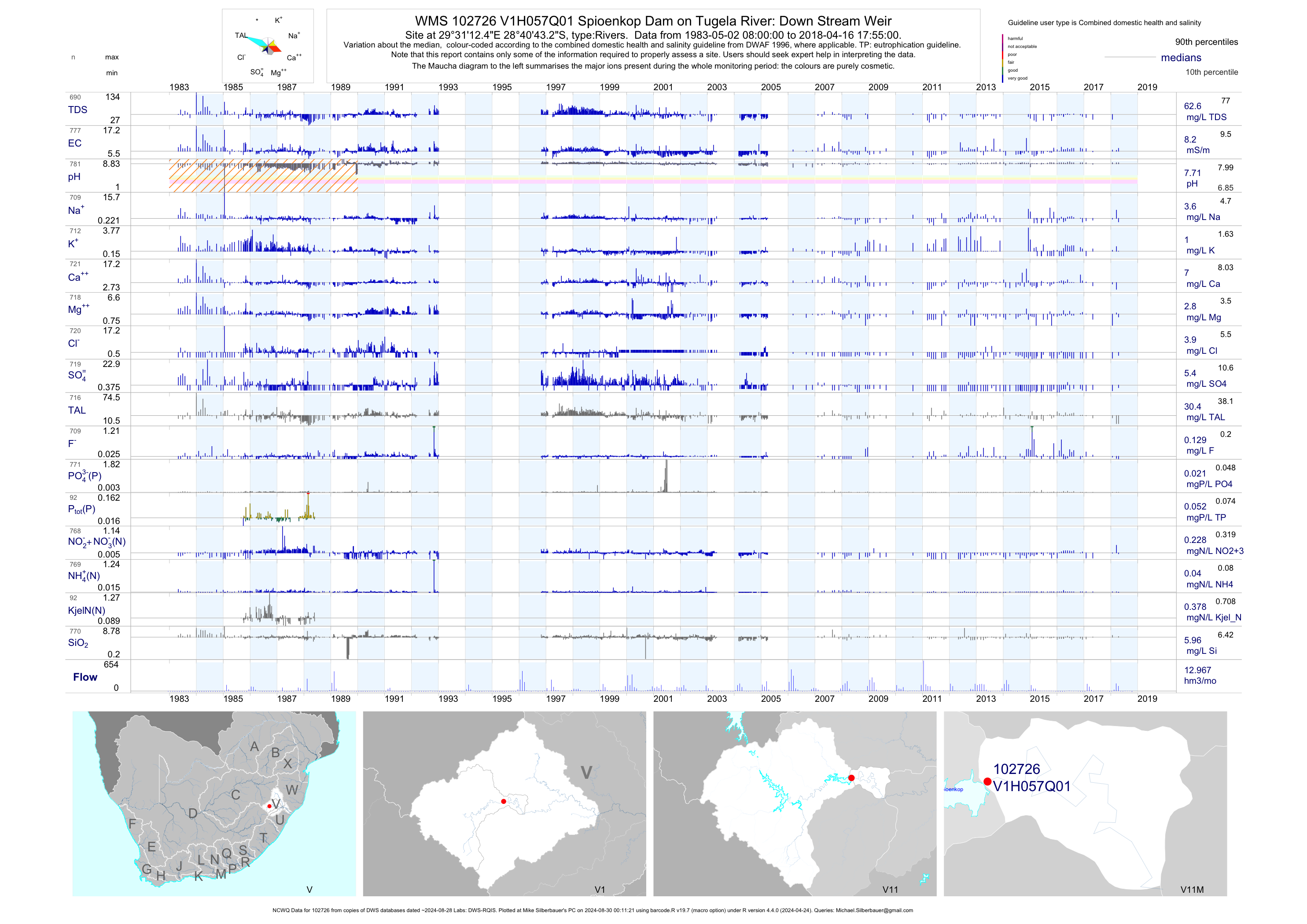
| V11 102726 | plot | data | Spioenkop Dam on Tugela River: Down Stream Weir (NCWQ) | Rivers | 781 | 1983-05-02 | 2018-04-16 | 8 | V1H057 | -28.67869 | 29.52013 |
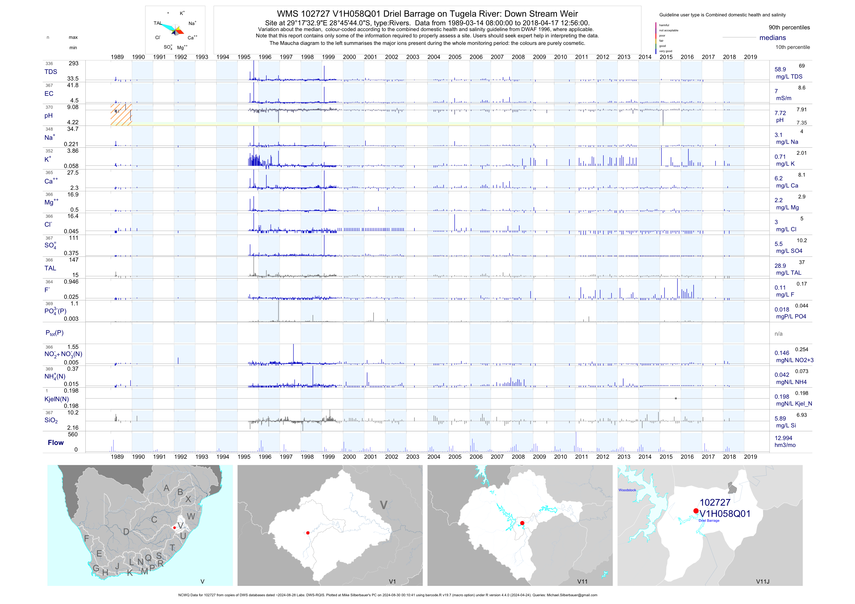
| V11 102727 | plot | data | Driel Barrage on Tugela River: Down Stream Weir (NCWQ) | Rivers | 370 | 1989-03-14 | 2018-04-17 | 7 | V1H058 | -28.76222 | 29.29250 |
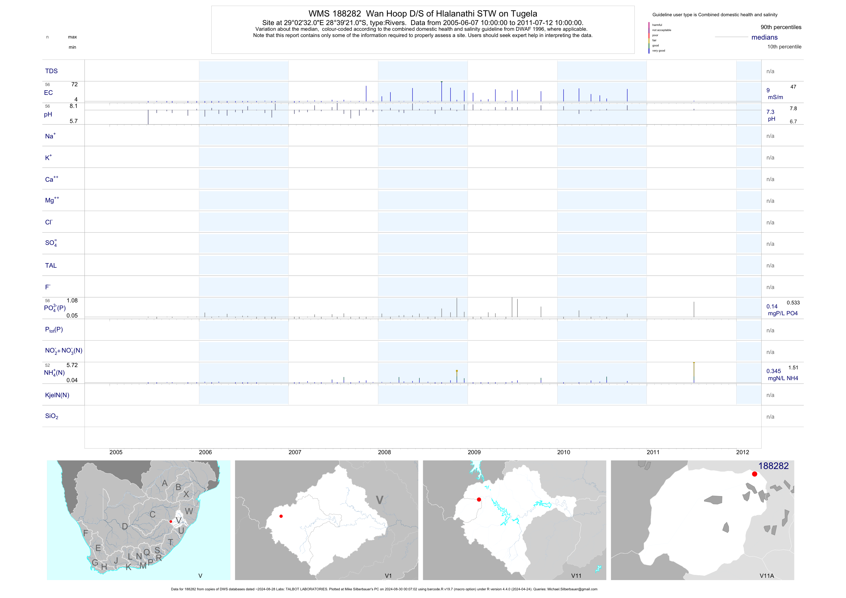
| V11 188282 | plot | data | Wan Hoop D/S of Hlalanathi STW on Tugela | Rivers | 73 | 2005-06-07 | 2011-07-12 | 9 | 188282 | -28.65583 | 29.04222 |
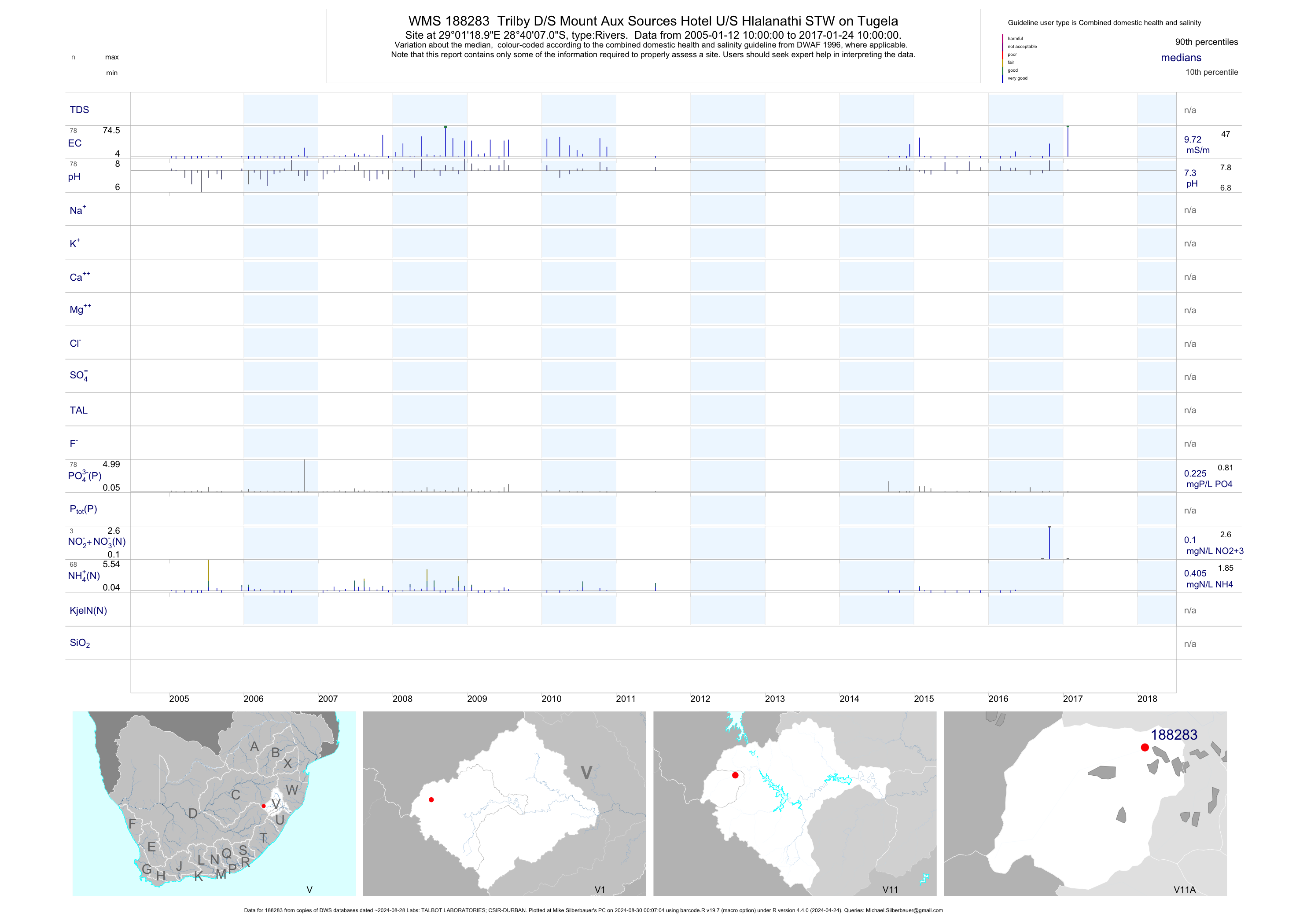
| V11 188283 | plot | data | Trilby D/S Mount Aux Sources Hotel U/S Hlalanathi STW on Tugela | Rivers | 109 | 2005-01-12 | 2017-02-28 | 10 | 188283 | -28.66861 | 29.02194 |
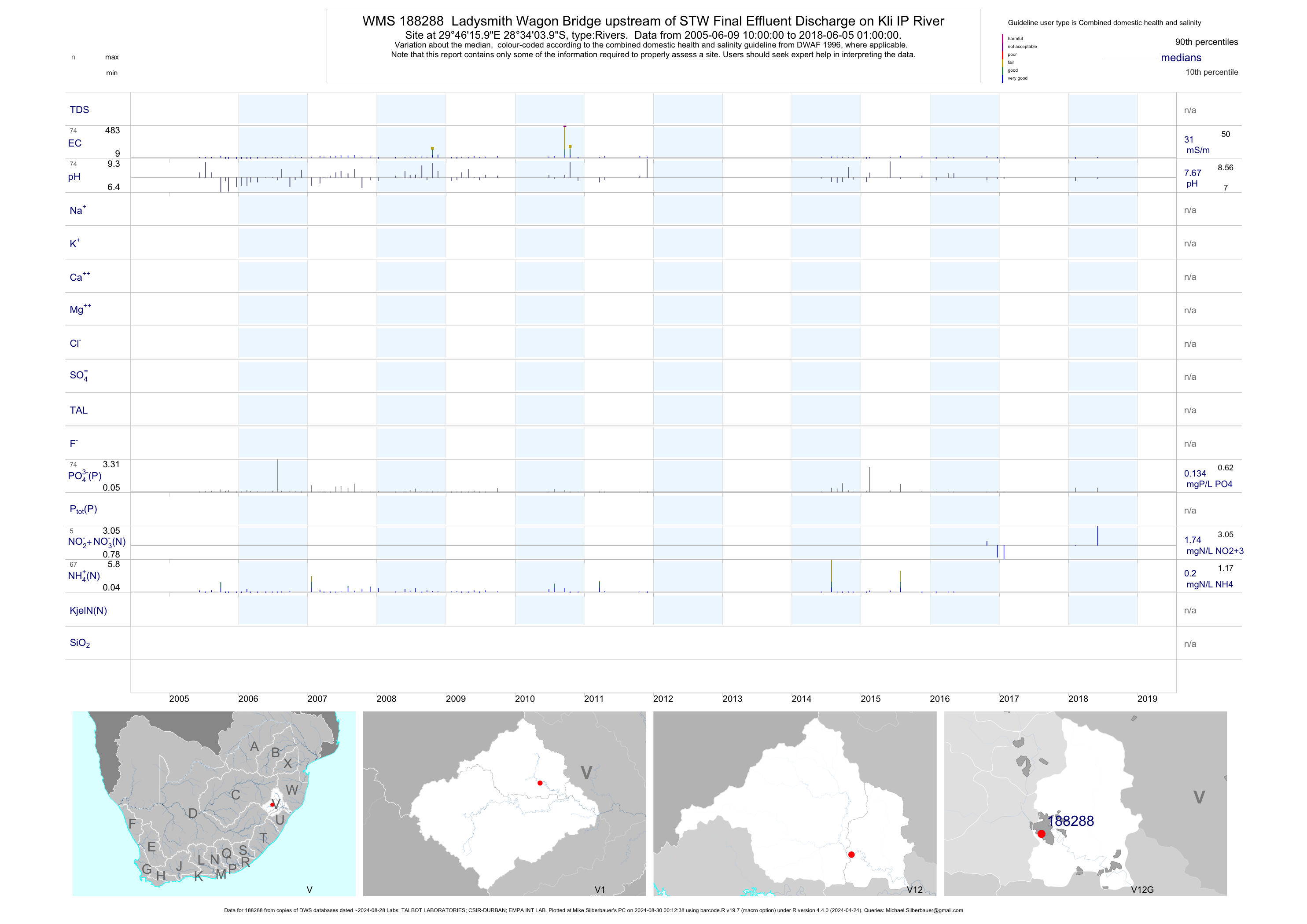
| V12 188288 | plot | data | Ladysmith Wagon Bridge upstream of STW Final Effluent Discharge on Kli IP River | Rivers | 106 | 2005-06-09 | 2017-03-16 | 31 | 188288 | -28.56778 | 29.77111 |
| V12 188289 | plot | data | Ladysmith downstream of STW Discharrge on Klip Rever | Rivers | 108 | 2005-06-09 | 2018-06-05 | 33 | 188289 | -28.57944 | 29.80139 |
| V11 188292 | plot | data | Upstream of Royal National Park STW on Golide | Rivers | 109 | 2005-01-12 | 2017-02-28 | 6 | 188292 | -28.68611 | 28.95333 |
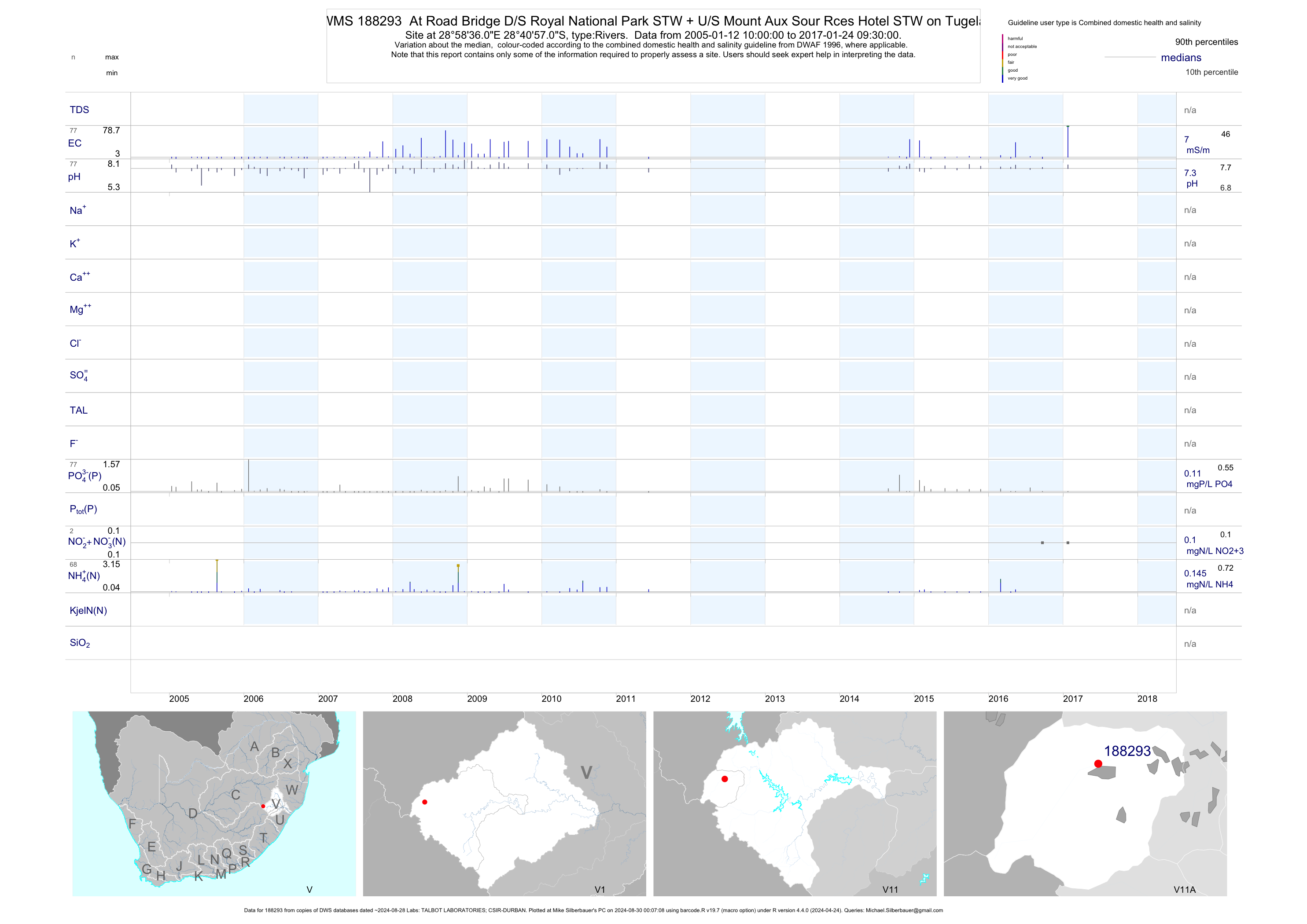
| V11 188293 | plot | data | At Road Bridge D/S Royal National Park STW + U/S Mount Aux Sour Rces Hotel STW on Tugela | Rivers | 107 | 2005-01-12 | 2017-02-28 | 7 | 188293 | -28.68250 | 28.97667 |
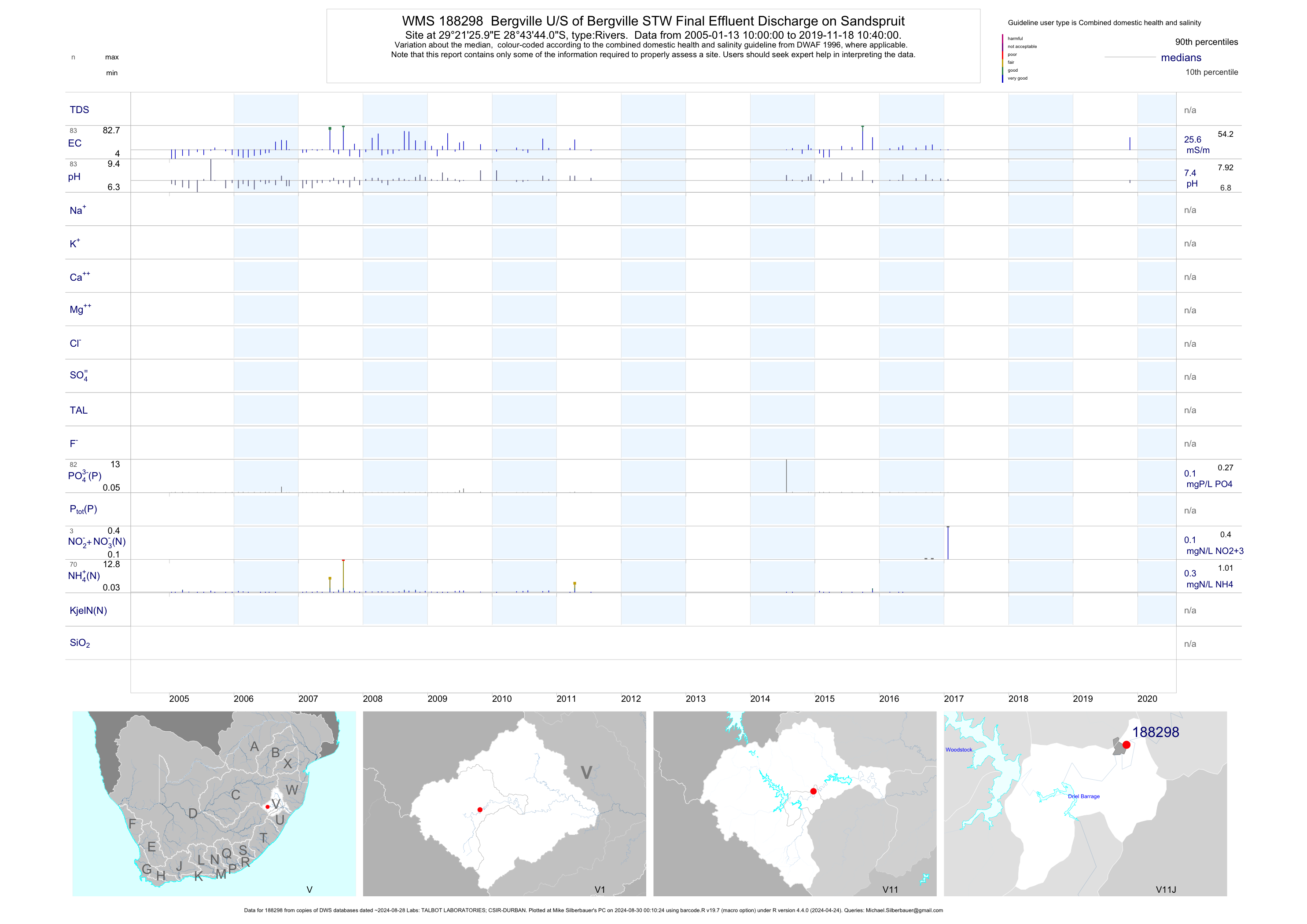
| V11 188298 | plot | data | Bergville U/S of Bergville STW Final Effluent Discharge on Sandspruit | Rivers | 108 | 2005-01-13 | 2017-02-27 | 25 | 188298 | -28.72889 | 29.35722 |
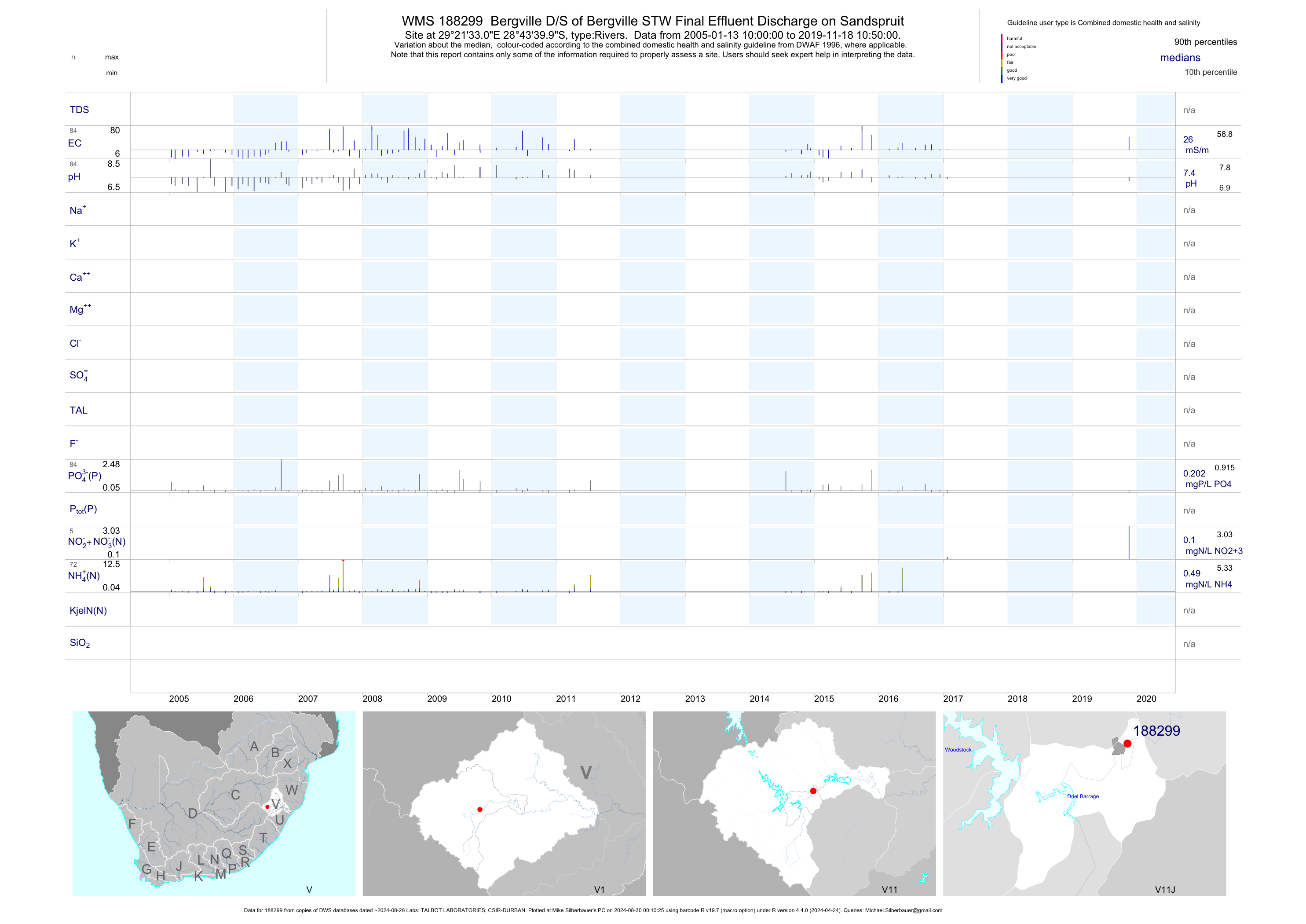
| V11 188299 | plot | data | Bergville D/S of Bergville STW Final Effluent Discharge on Sandspruit | Rivers | 112 | 2005-01-13 | 2017-02-27 | 26 | 188299 | -28.72778 | 29.35917 |
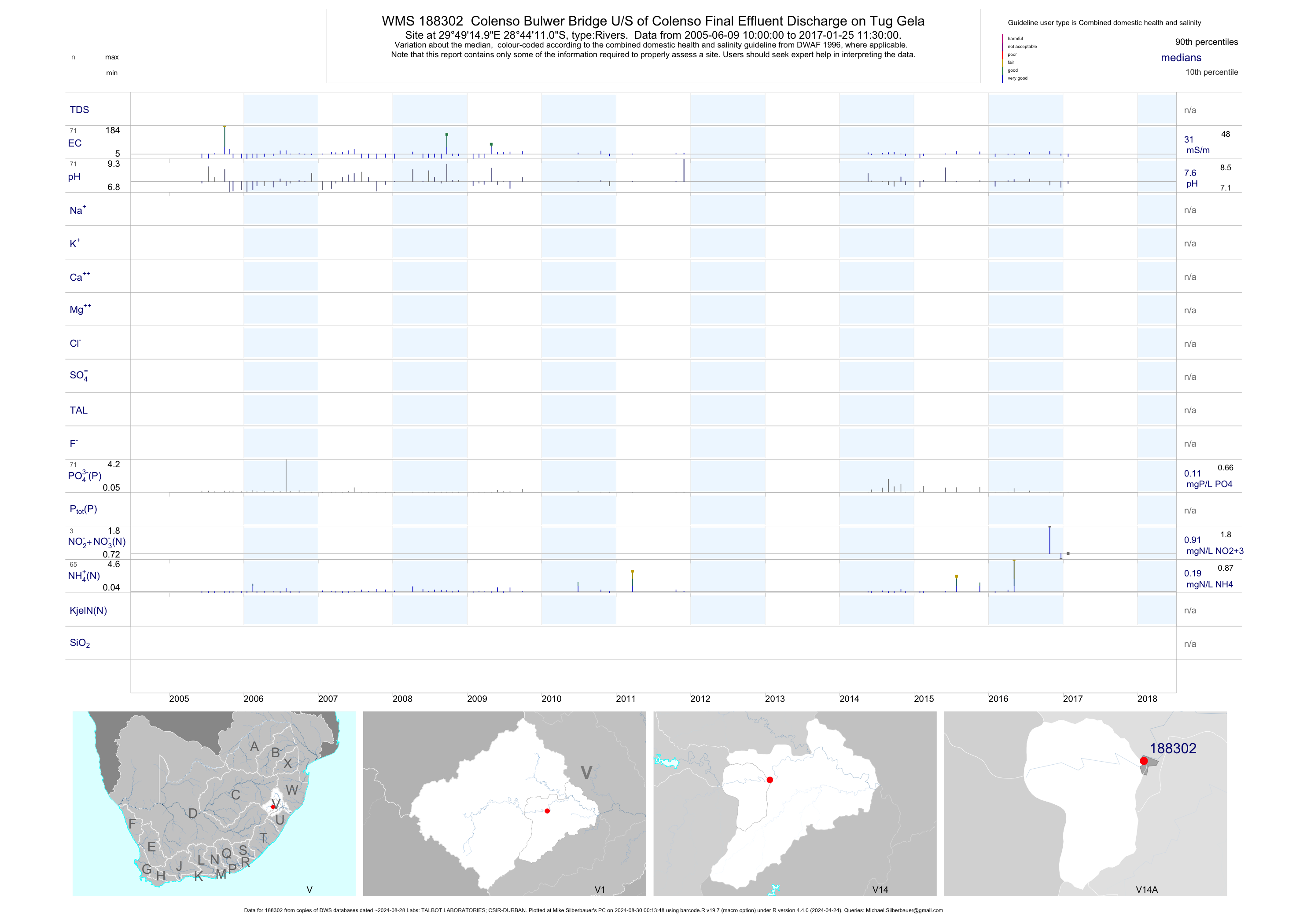
| V14 188302 | plot | data | Colenso Bulwer Bridge U/S of Colenso Final Effluent Discharge on Tug Gela | Rivers | 104 | 2005-06-09 | 2017-03-16 | 31 | 188302 | -28.73639 | 29.82083 |
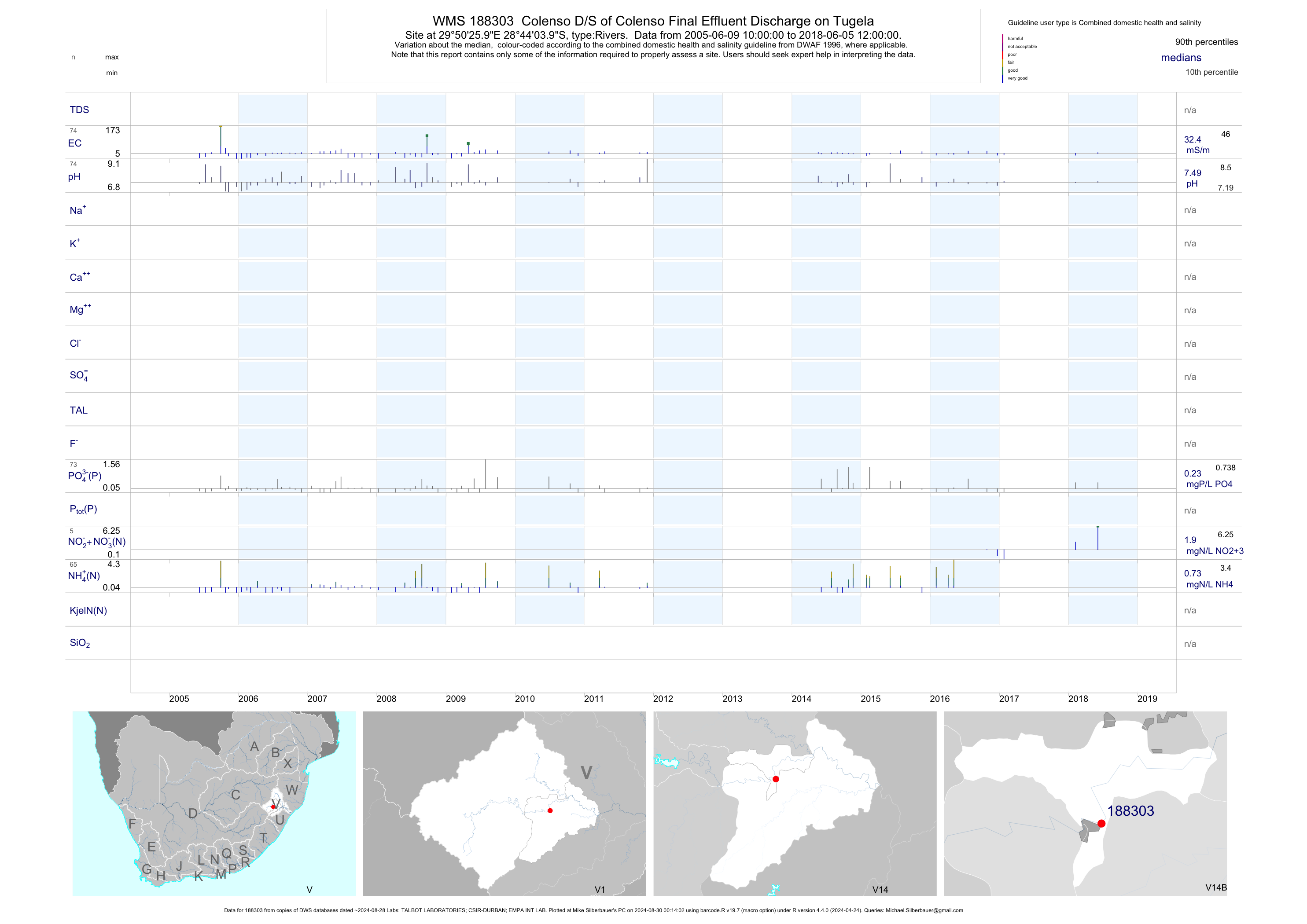
| V14 188303 | plot | data | Colenso D/S of Colenso Final Effluent Discharge on Tugela | Rivers | 105 | 2005-06-09 | 2017-03-16 | 33 | 188303 | -28.73444 | 29.84056 |
| V11 188305 | plot | data | Kruisfontein Bergville Harrismith Road Bridge U/S Woodstock Dam on Majane Eni | Rivers | 64 | 2005-09-14 | 2017-02-28 | 16 | 188305 | -28.62722 | 29.12139 |
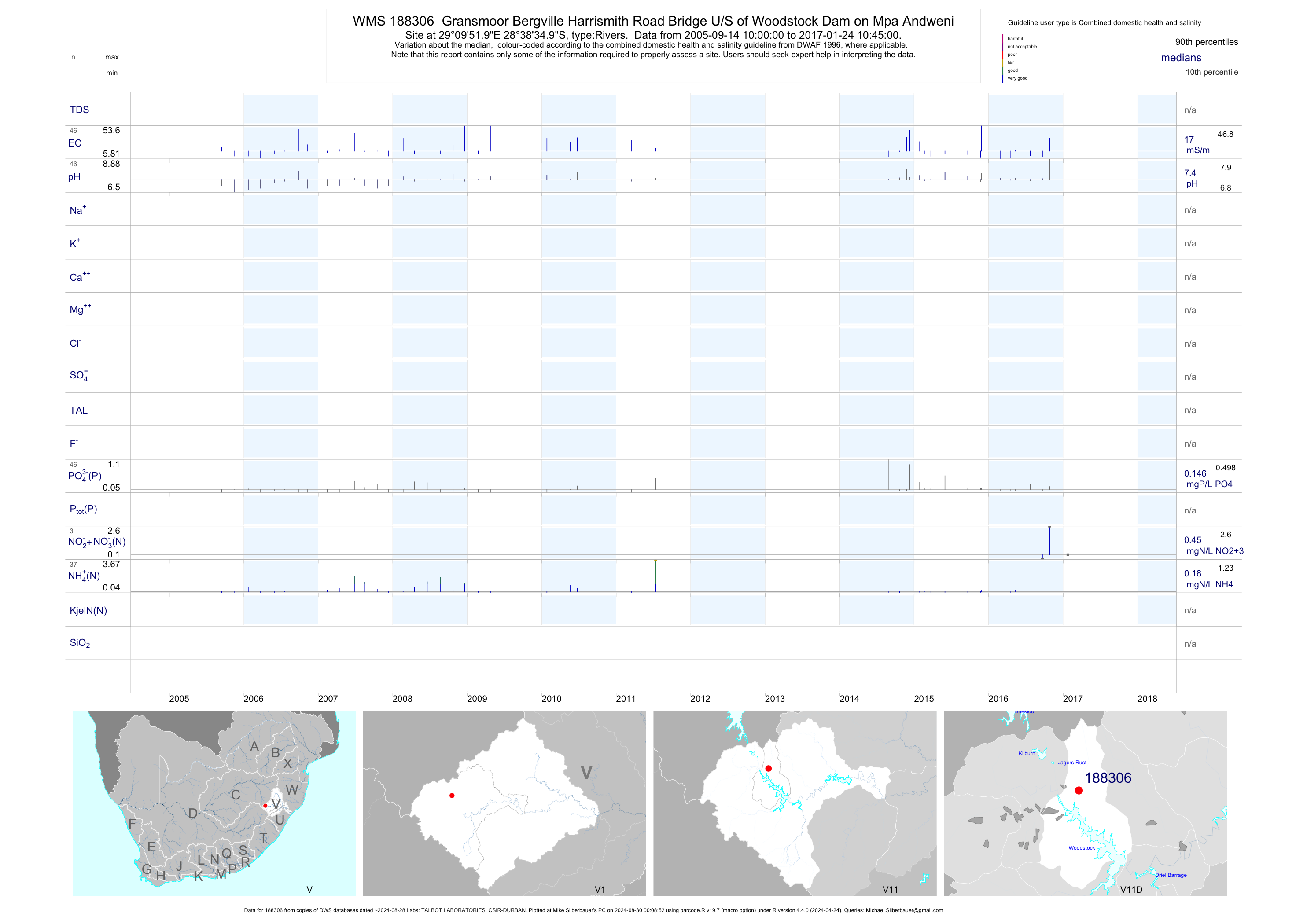
| V11 188306 | plot | data | Gransmoor Bergville Harrismith Road Bridge U/S of Woodstock Dam on Mpa Andweni | Rivers | 64 | 2005-09-14 | 2017-02-28 | 17 | 188306 | -28.64306 | 29.16444 |
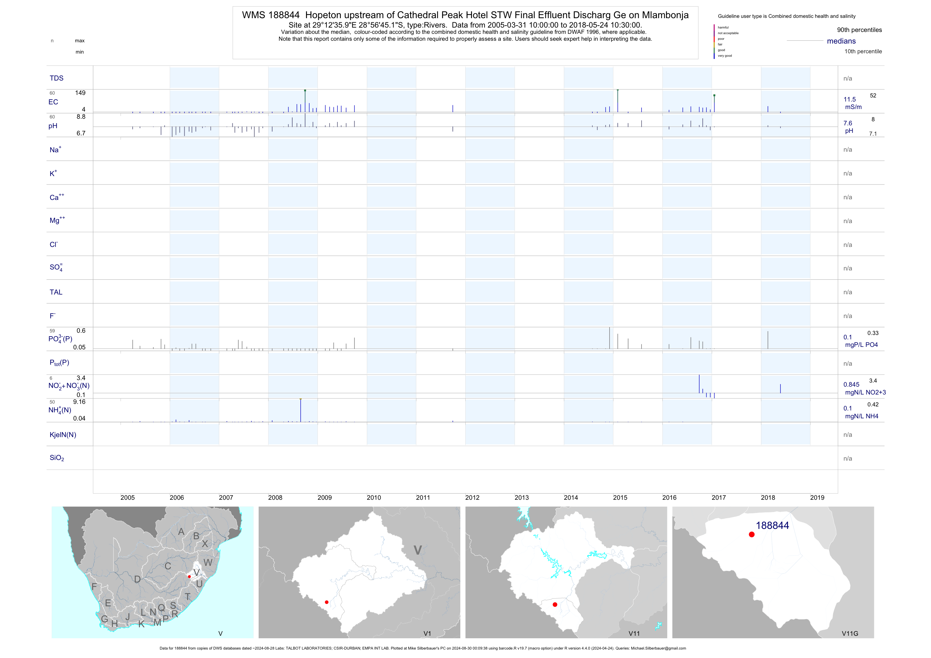
| V11 188844 | plot | data | Hopeton upstream of Cathedral Peak Hotel STW Final Effluent Discharg Ge on Mlambonja | Rivers | 84 | 2005-03-31 | 2017-03-15 | 13 | 188844 | -28.94589 | 29.20997 |
| V11 188861 | plot | data | Hopeton downstream of Cathedral Peak Hotel STW Final Effluent Discha Arge on Mlambonja | Rivers | 84 | 2005-03-31 | 2017-03-15 | 15 | 188861 | -28.94586 | 29.21008 |
| V13 189136 | plot | data | Winterton D/S of Winterton STW Final Discharge on Little Tugela | Rivers | 67 | 2006-07-26 | 2017-03-14 | 33 | 189136 | -28.80953 | 29.53525 |
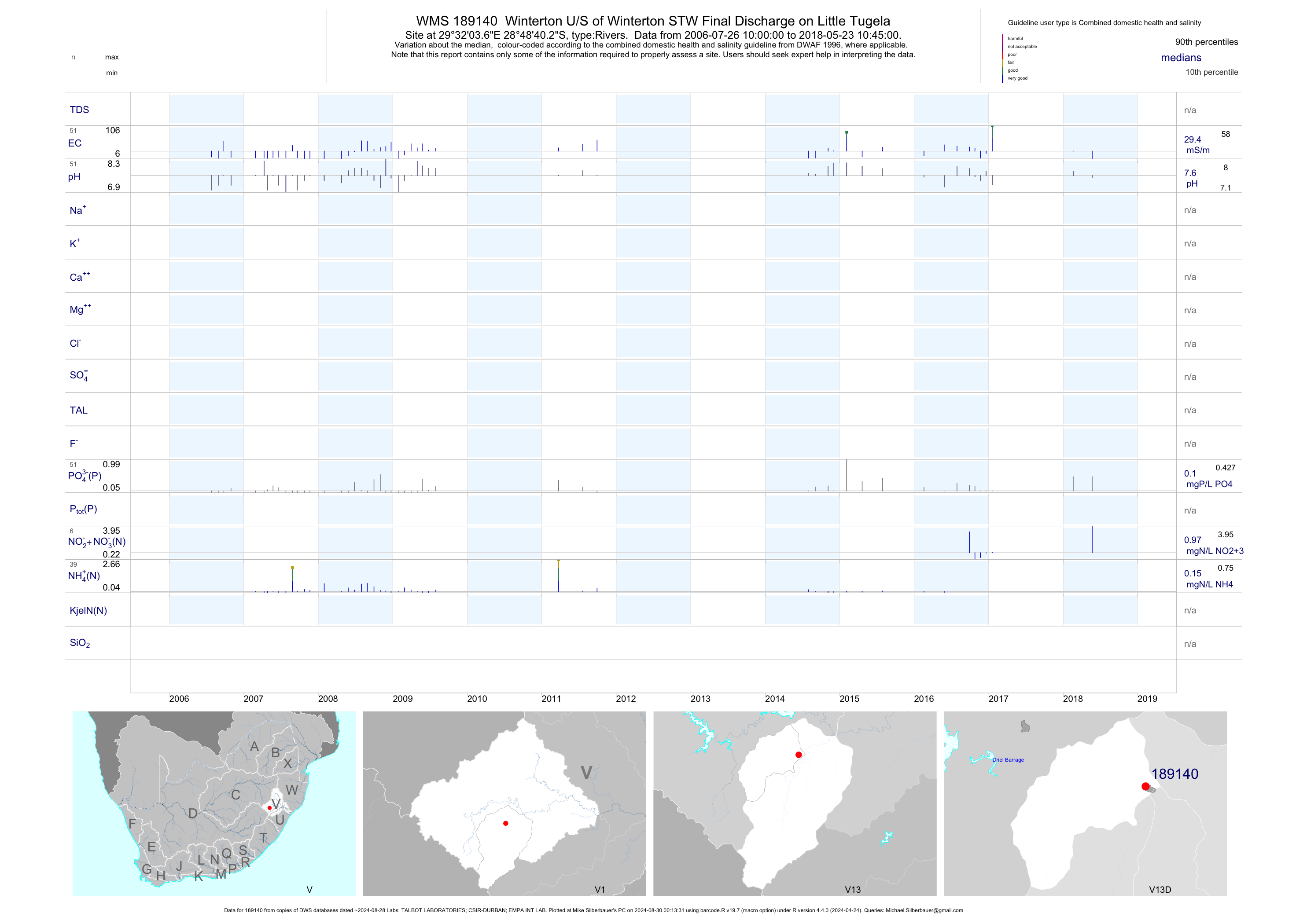
| V13 189140 | plot | data | Winterton U/S of Winterton STW Final Discharge on Little Tugela | Rivers | 65 | 2006-07-26 | 2017-03-14 | 31 | 189140 | -28.81117 | 29.53433 |
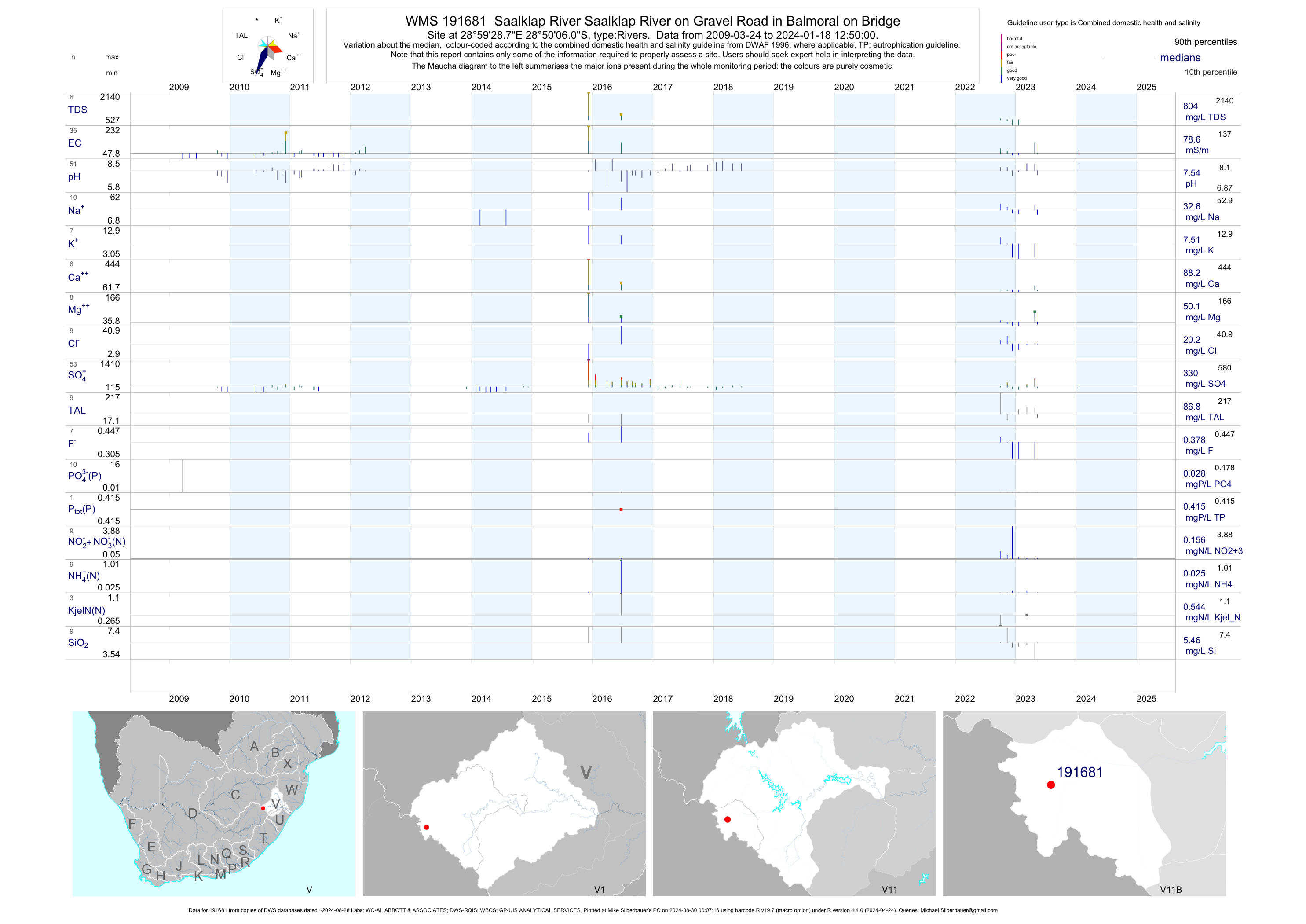
| V11 191681 | plot | data | Saalklap River Saalklap River on Gravel Road in Balmoral on Bridge | Rivers | 56 | 2009-03-24 | 2018-06-20 | 68 | 191681 | -28.83503 | 28.99133 |
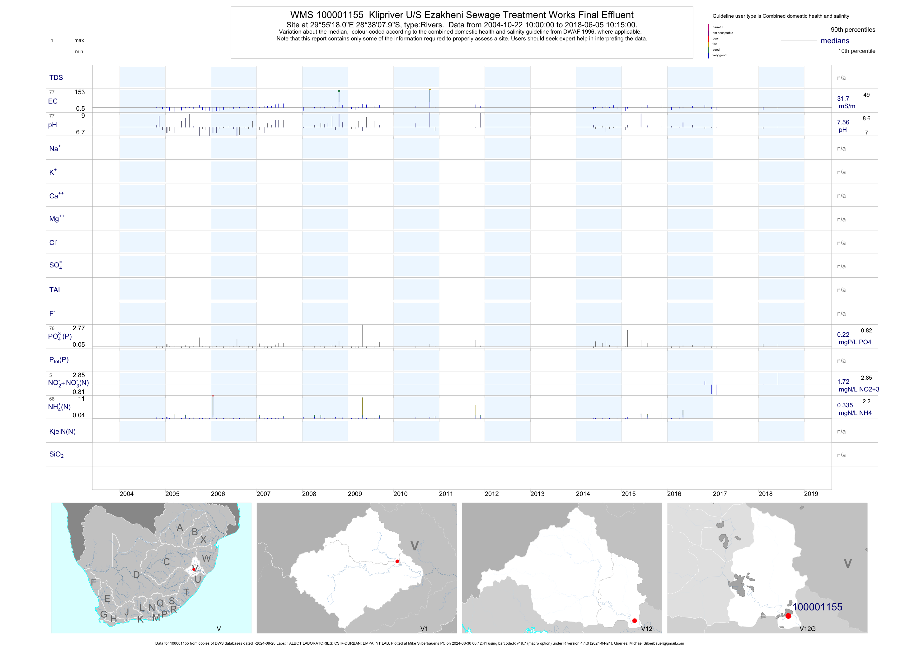
| V12 100001155 | plot | data | Klipriver U/S Ezakheni Sewage Treatment Works Final Effluent | Rivers | 90 | 2004-10-22 | 2018-06-05 | 32 | 1-1155 | -28.63556 | 29.92167 |
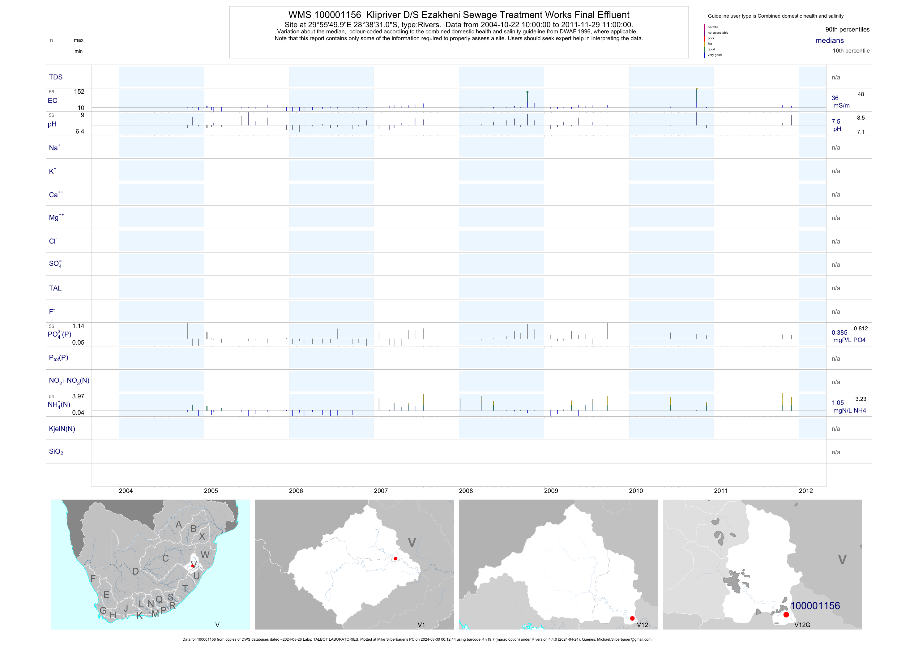
| V12 100001156 | plot | data | Klipriver D/S Ezakheni Sewage Treatment Works Final Effluent | Rivers | 57 | 2004-10-22 | 2011-11-29 | 36 | 1-1156 | -28.64194 | 29.93056 |
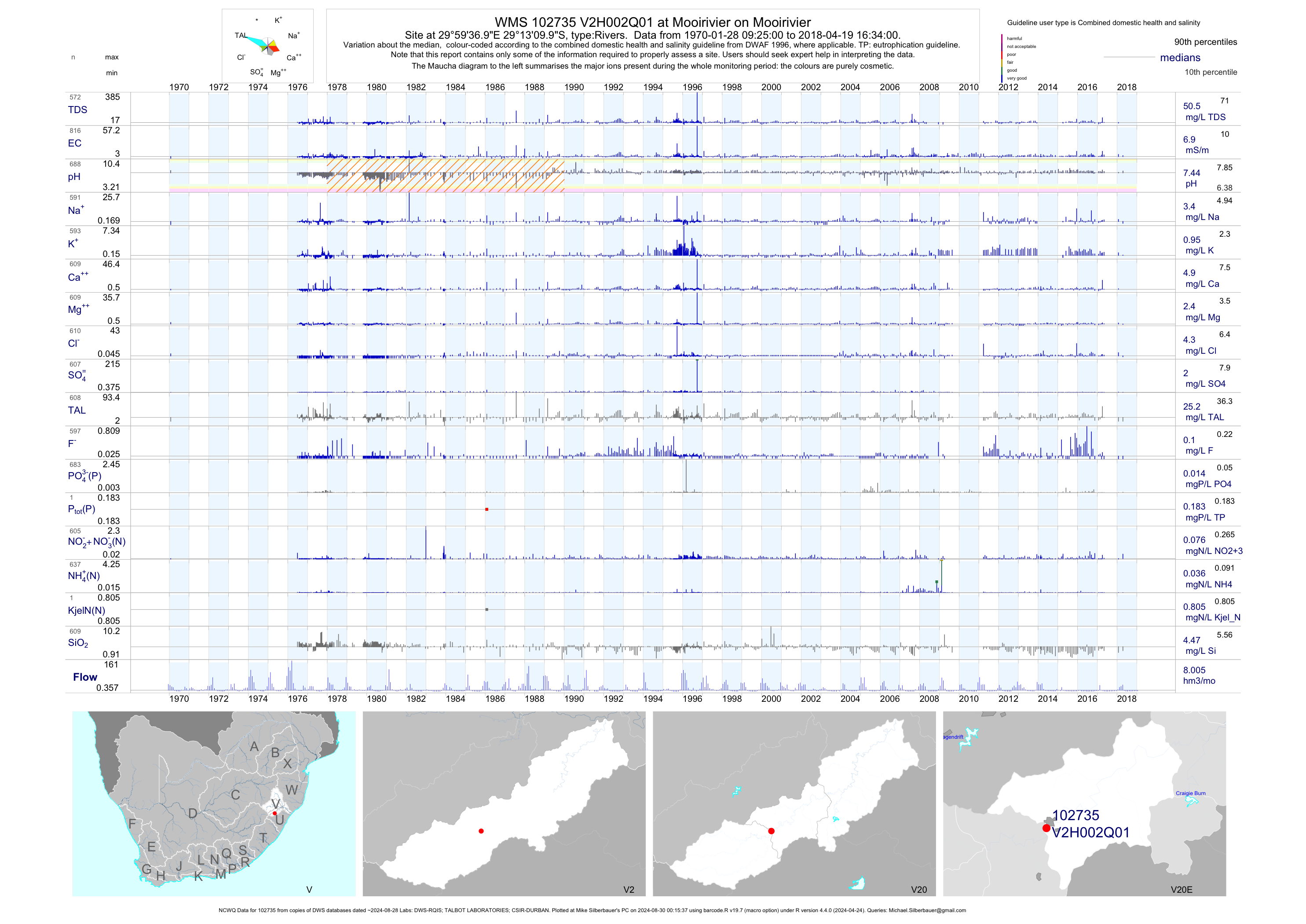
| V20 102735 | plot | data | at Mooirivier on Mooirivier (NCWQ) | Rivers | 1249 | 1970-01-28 | 2018-04-19 | 7 | V2H002 | -29.21944 | 29.99361 |
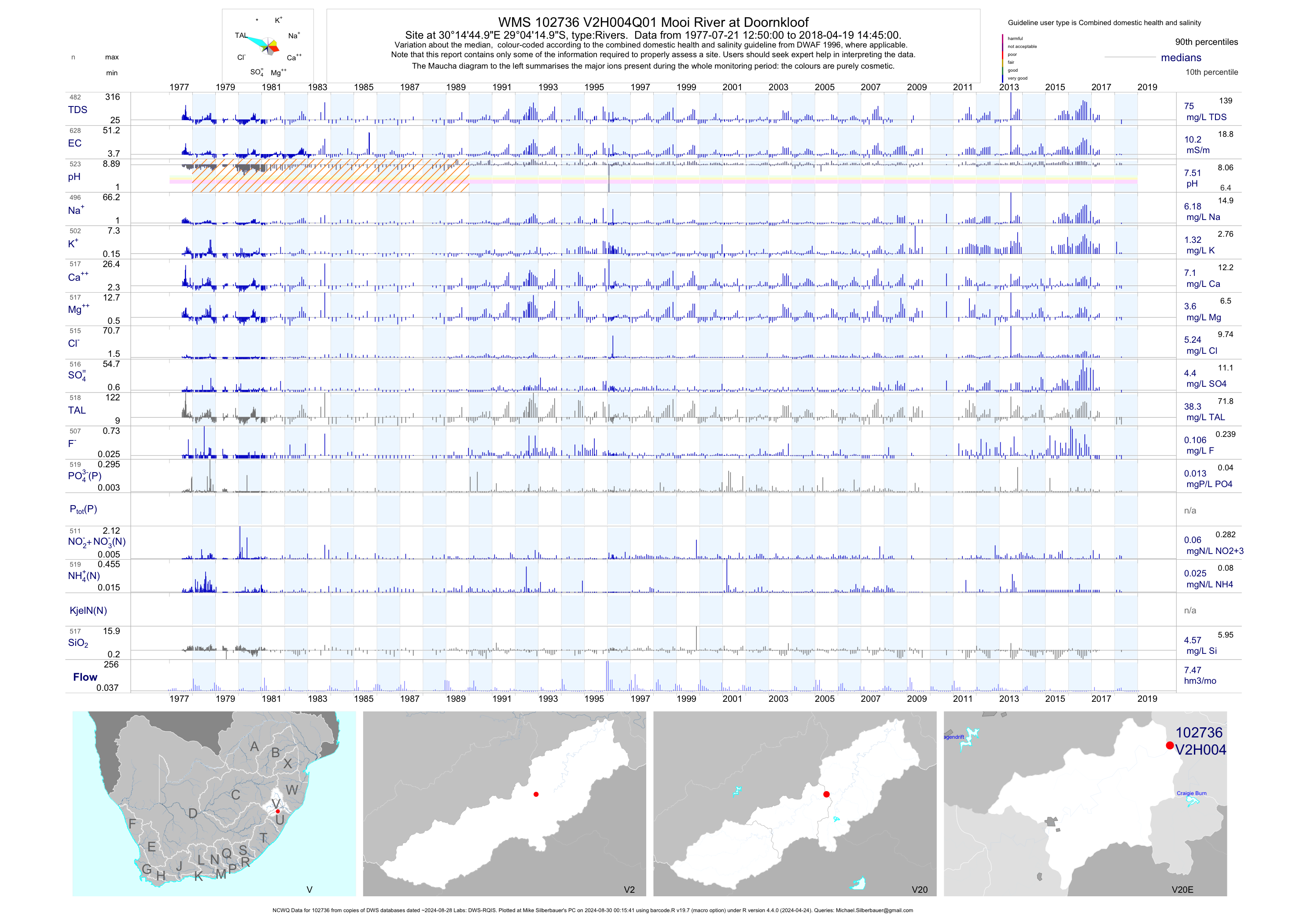
| V20 102736 | plot | data | Mooi River at Doornkloof (NCWQ) | Rivers | 629 | 1977-07-21 | 2018-04-19 | 10 | V2H004 | -29.07083 | 30.24583 |
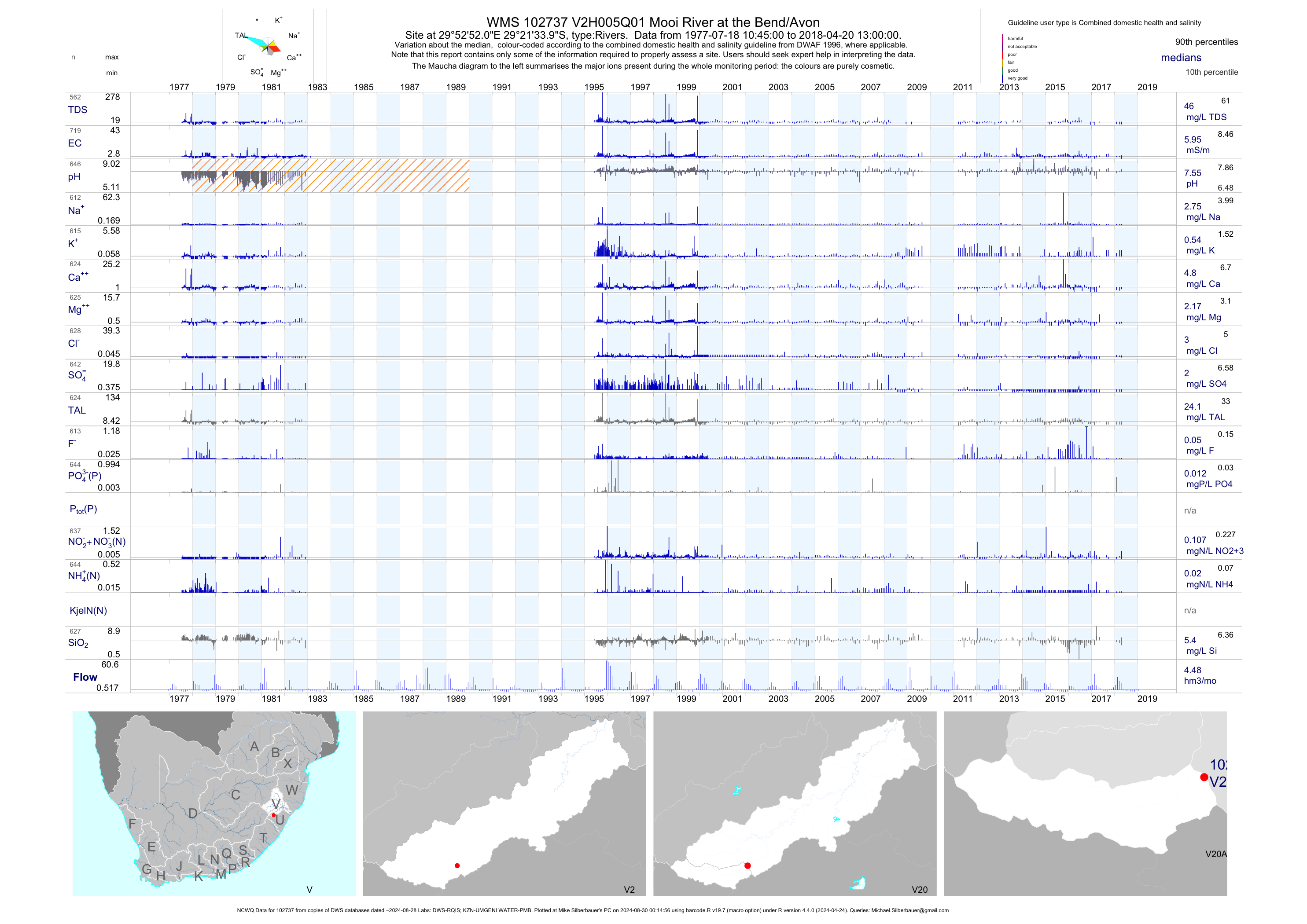
| V20 102737 | plot | data | Mooi River at the Bend/Avon (NCWQ) | Rivers | 794 | 1977-07-18 | 2018-04-20 | 6 | V2H005 | -29.35944 | 29.88111 |
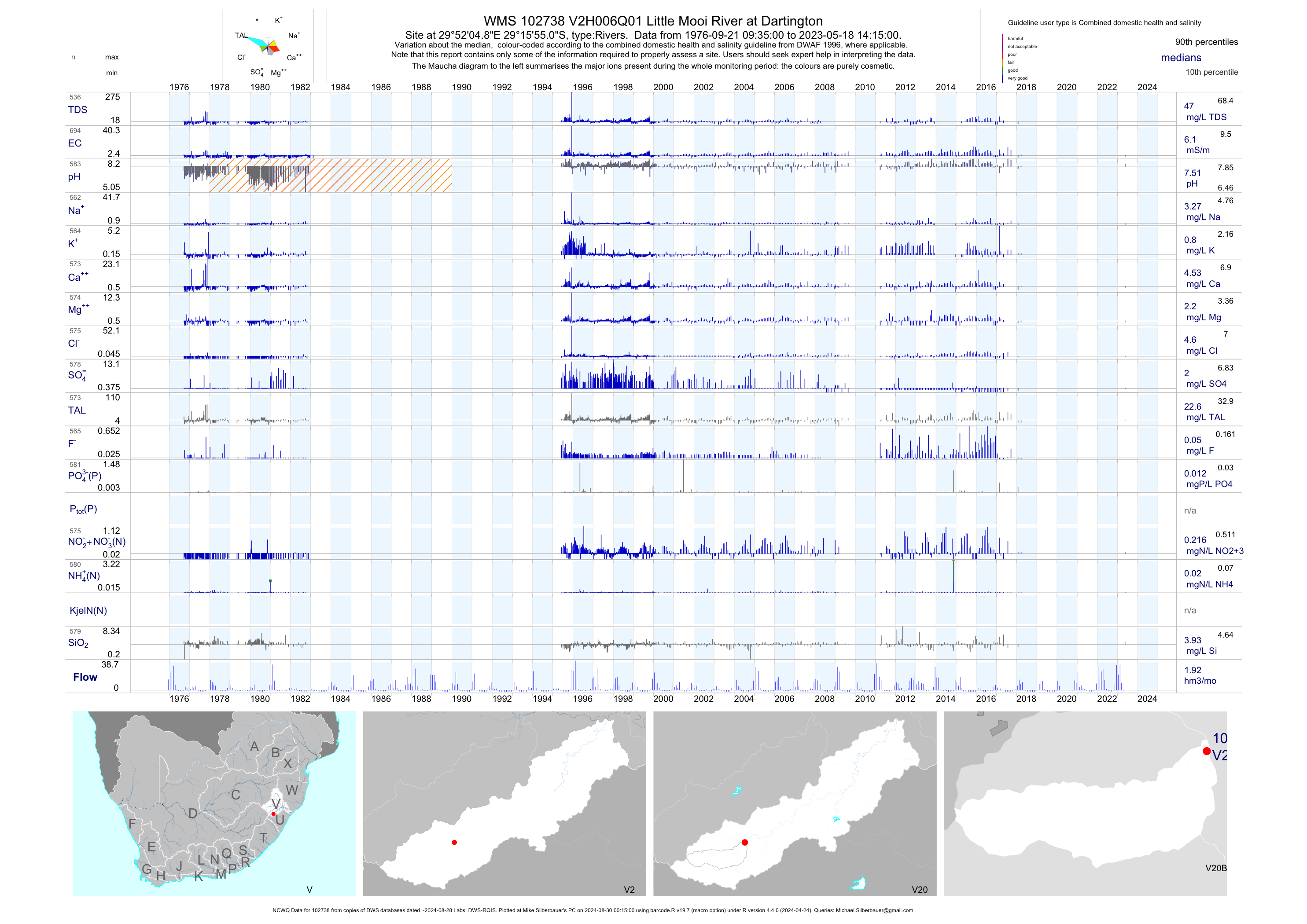
| V20 102738 | plot | data | Little Mooi River at Dartington (NCWQ) | Rivers | 694 | 1976-09-21 | 2018-03-22 | 6 | V2H006 | -29.26529 | 29.86802 |
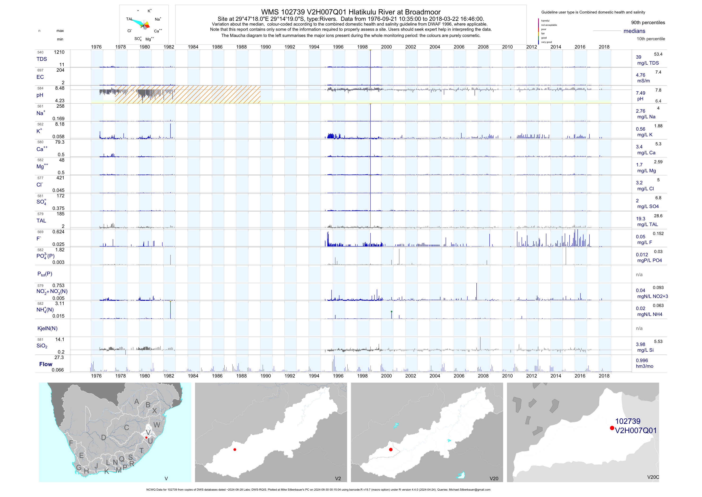
| V20 102739 | plot | data | Hlatikulu River at Broadmoor (NCWQ) | Rivers | 699 | 1976-09-21 | 2018-03-22 | 5 | V2H007 | -29.23861 | 29.78833 |
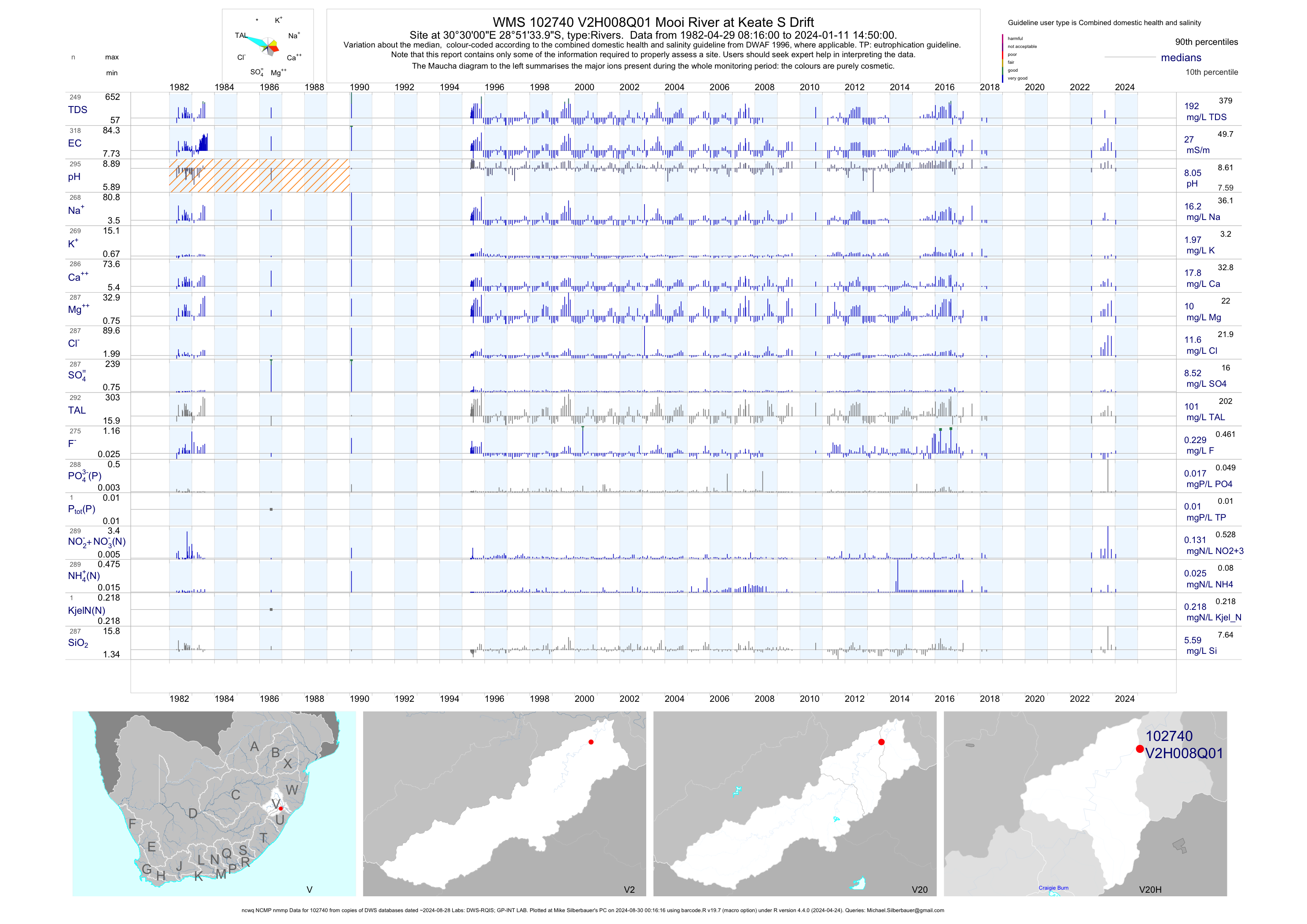
| V20 102740 | plot | data | Mooi River at Keate S Drift (ncwq NCMP nmmp) | Rivers | 312 | 1982-04-29 | 2018-04-19 | 27 | V2H008 | -28.85944 | 30.50000 |
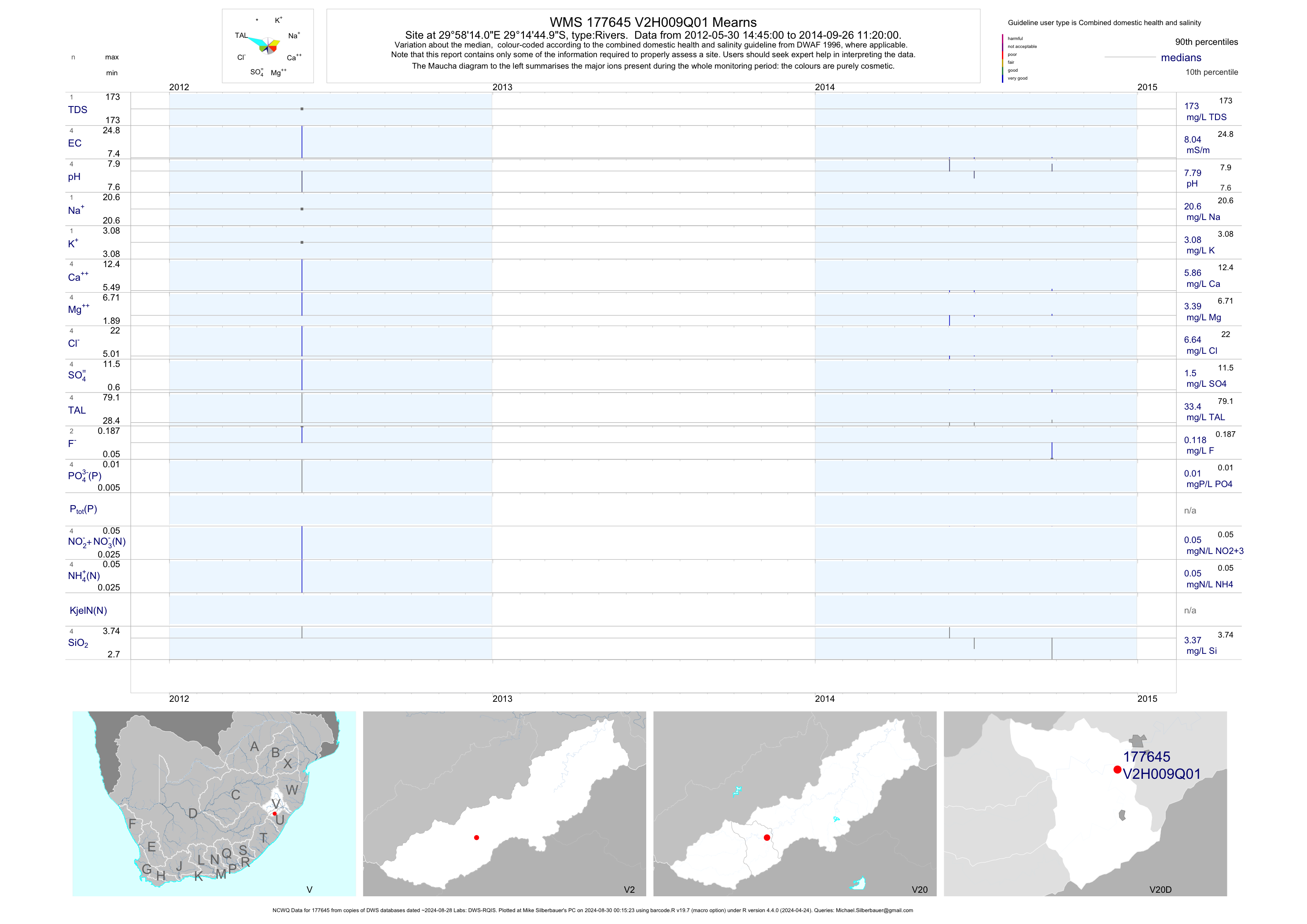
| V20 177645 | plot | data | Mearns (NCWQ) | Rivers | 4 | 2012-05-30 | 2014-09-26 | 8 | V2H009 | -29.24583 | 29.97056 |
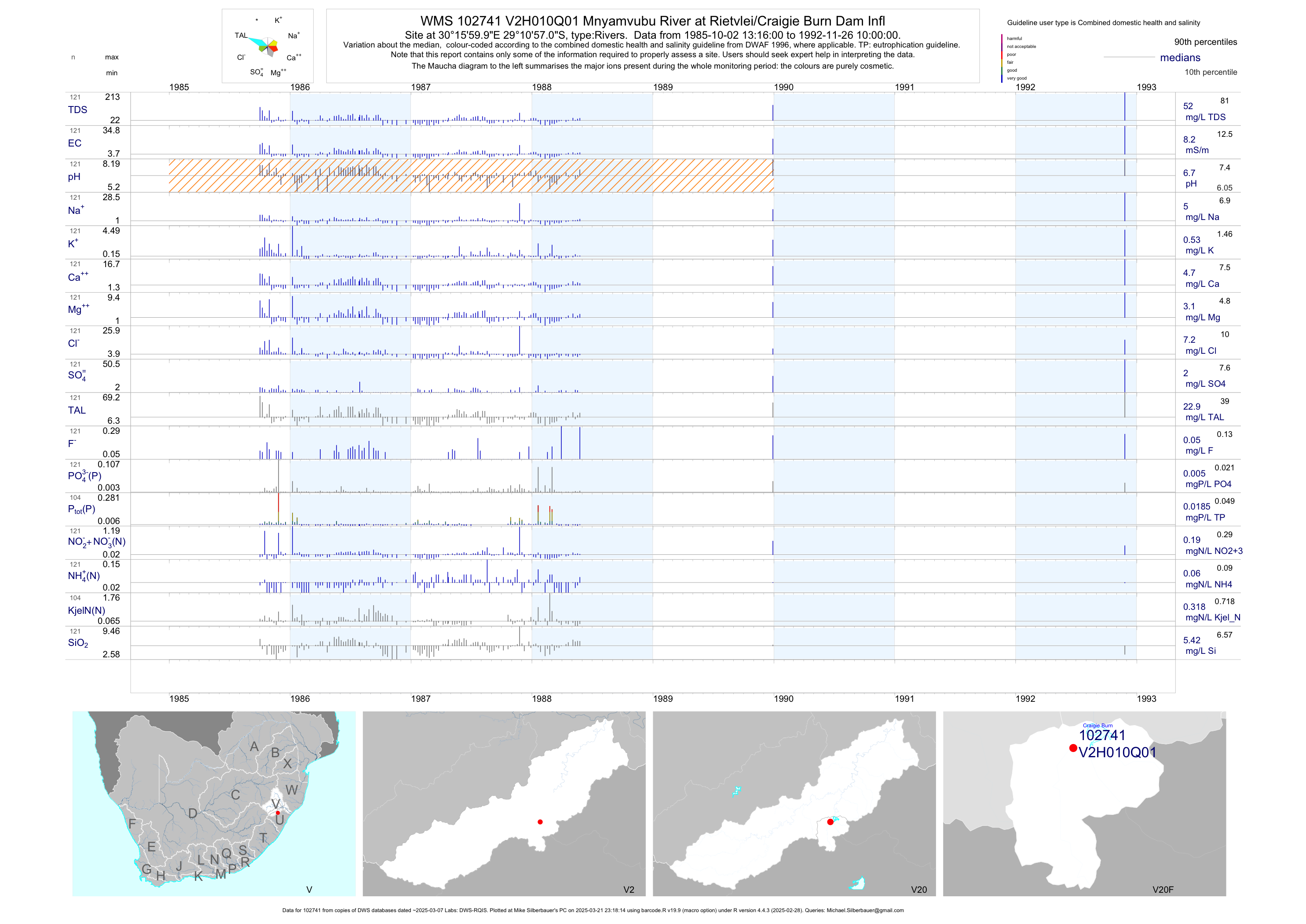
| V20 102741 | plot | data | Mnyamvubu River at Rietvlei/Craigie Burn Dam Infl | Rivers | 121 | 1985-10-02 | 1992-11-26 | 8 | V2H010 | -29.18250 | 30.26667 |
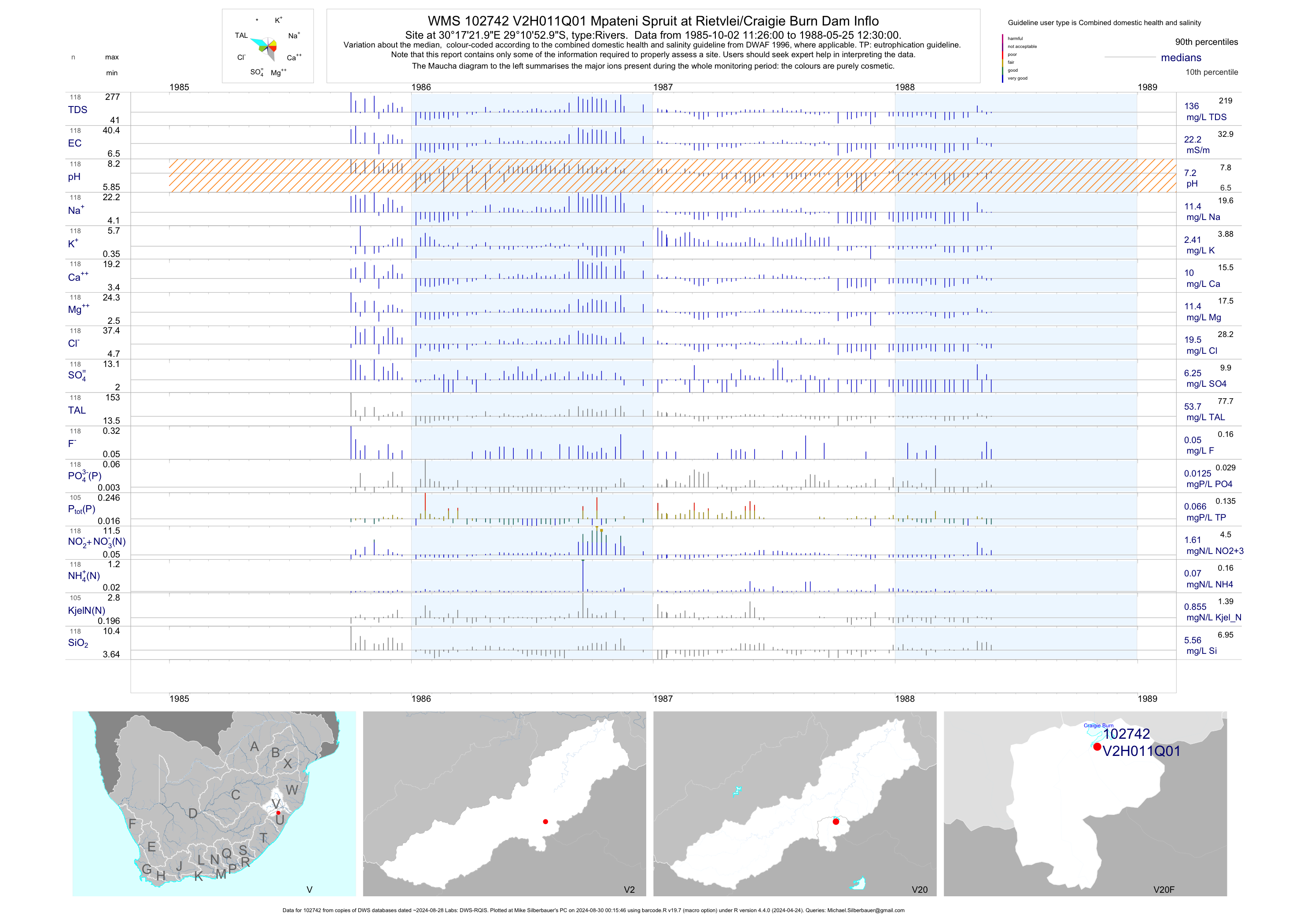
| V20 102742 | plot | data | Mpateni Spruit at Rietvlei/Craigie Burn Dam Inflo | Rivers | 118 | 1985-10-02 | 1988-05-25 | 22 | V2H011 | -29.18139 | 30.28944 |
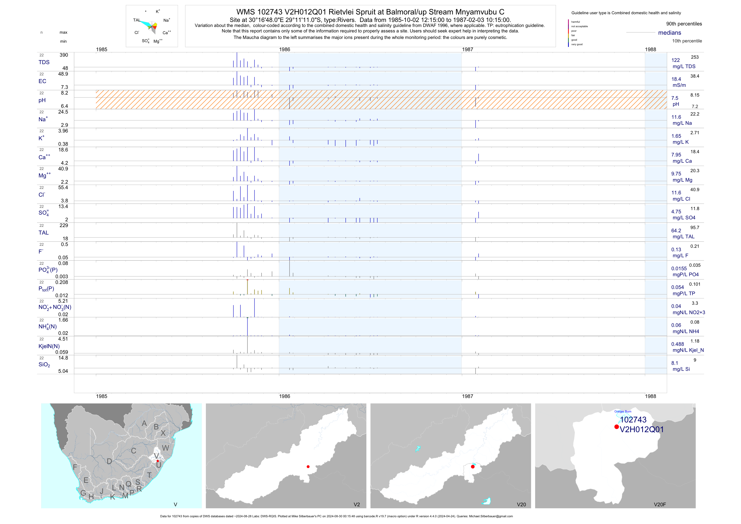
| V20 102743 | plot | data | Rietvlei Spruit at Balmoral/up Stream Mnyamvubu C | Rivers | 22 | 1985-10-02 | 1987-02-03 | 18 | V2H012 | -29.18639 | 30.28000 |
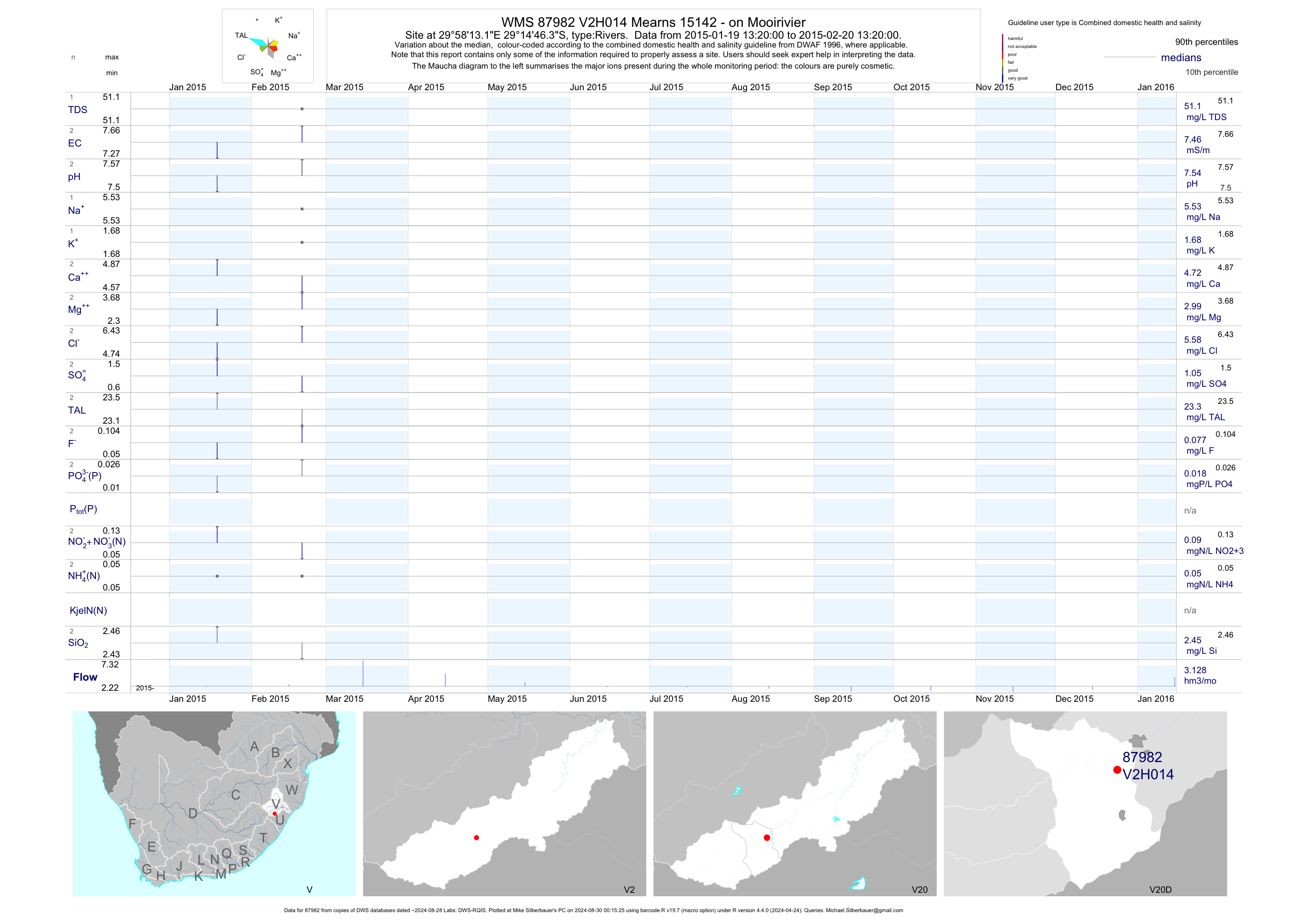
| V20 87982 | plot | data | Mearns 15142 - on Mooirivier | Rivers | 2 | 2015-01-19 | 2015-02-20 | 7 | V2H014 | -29.24619 | 29.97031 |
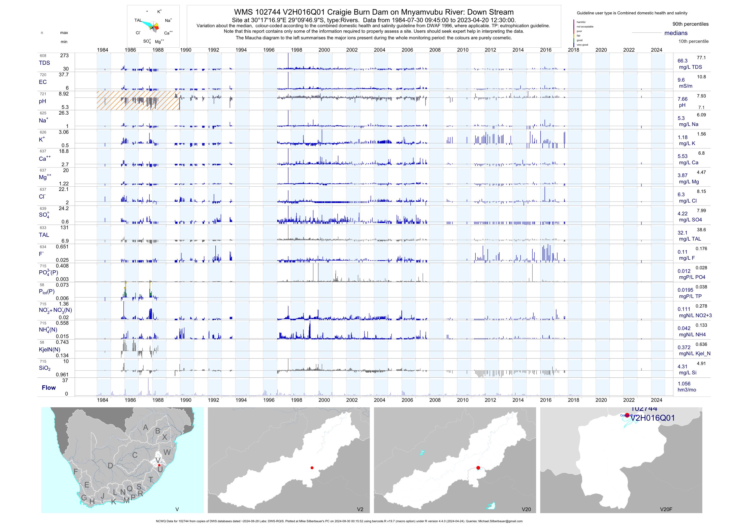
| V20 102744 | plot | data | Craigie Burn Dam on Mnyamvubu River: Down Stream (NCWQ) | Rivers | 720 | 1984-07-30 | 2017-10-11 | 10 | V2H016 | -29.16306 | 30.28806 |
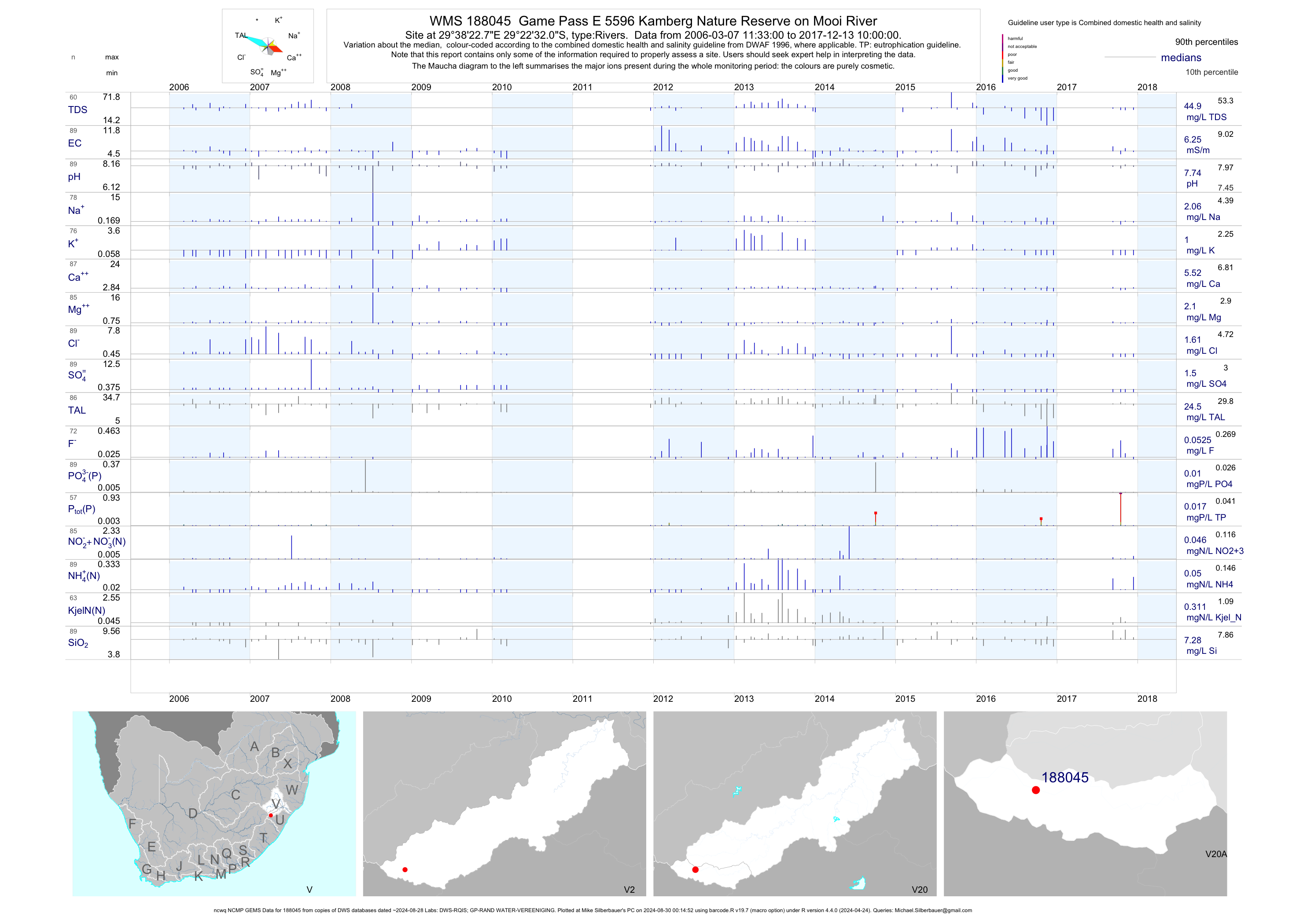
| V20 188045 | plot | data | Game Pass E 5596 Kamberg Nature Reserve on Mooi River (ncwq NCMP GEMS) | Rivers | 89 | 2006-03-07 | 2017-12-13 | 6 | 188045 | -29.37556 | 29.63964 |
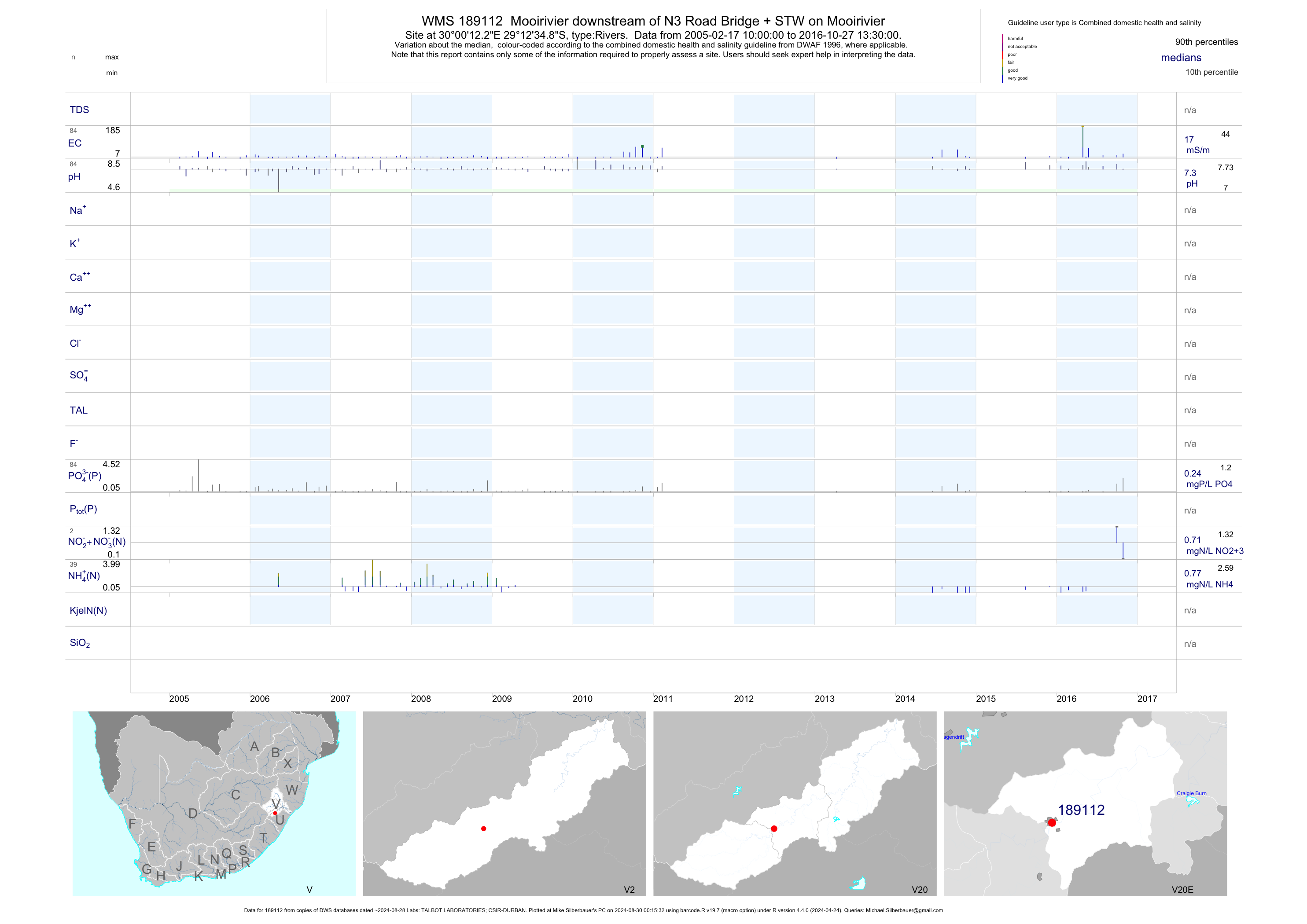
| V20 189112 | plot | data | Mooirivier downstream of N3 Road Bridge + STW on Mooirivier | Rivers | 112 | 2005-02-17 | 2016-10-27 | 17 | 189112 | -29.20967 | 30.00339 |
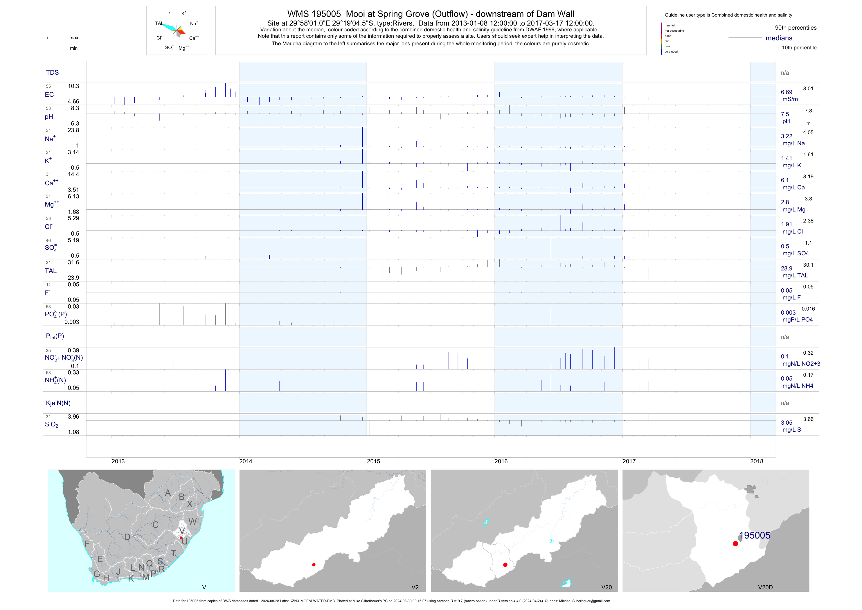
| V20 195005 | plot | data | Mooi at Spring Grove (Outflow) - downstream of Dam Wall | Rivers | 132 | 2013-01-08 | 2017-03-17 | 7 | 195005 | -29.31794 | 29.96695 |
| V20 195006 | plot | data | Little Mooi at Connington Road Bridge (upstream of Mearns) | Rivers | 119 | 2013-07-09 | 2017-03-28 | 7 | 195006 | -29.23197 | 29.92533 |
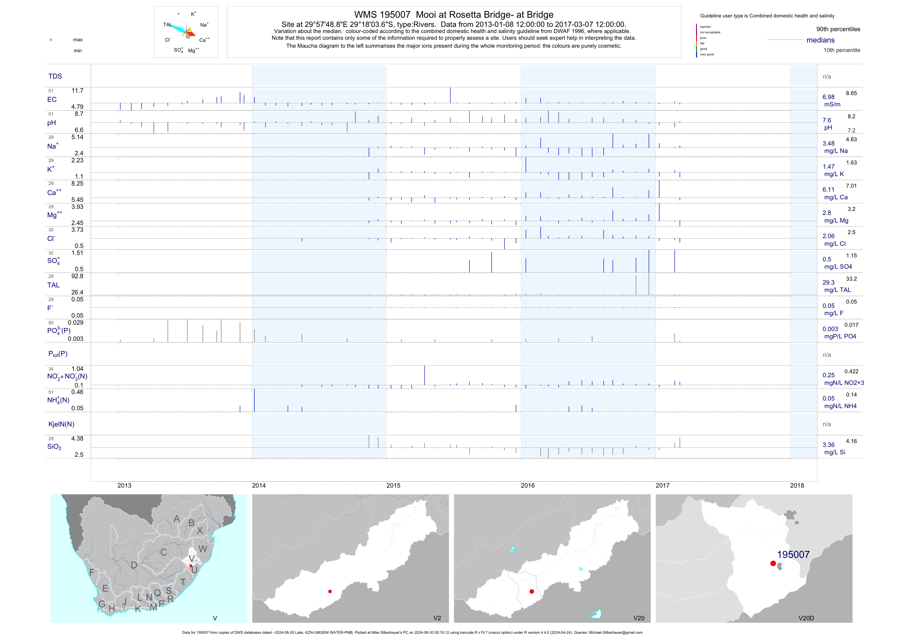
| V20 195007 | plot | data | Mooi at Rosetta Bridge- at Bridge | Rivers | 120 | 2013-01-08 | 2017-03-07 | 7 | 195007 | -29.30102 | 29.96356 |
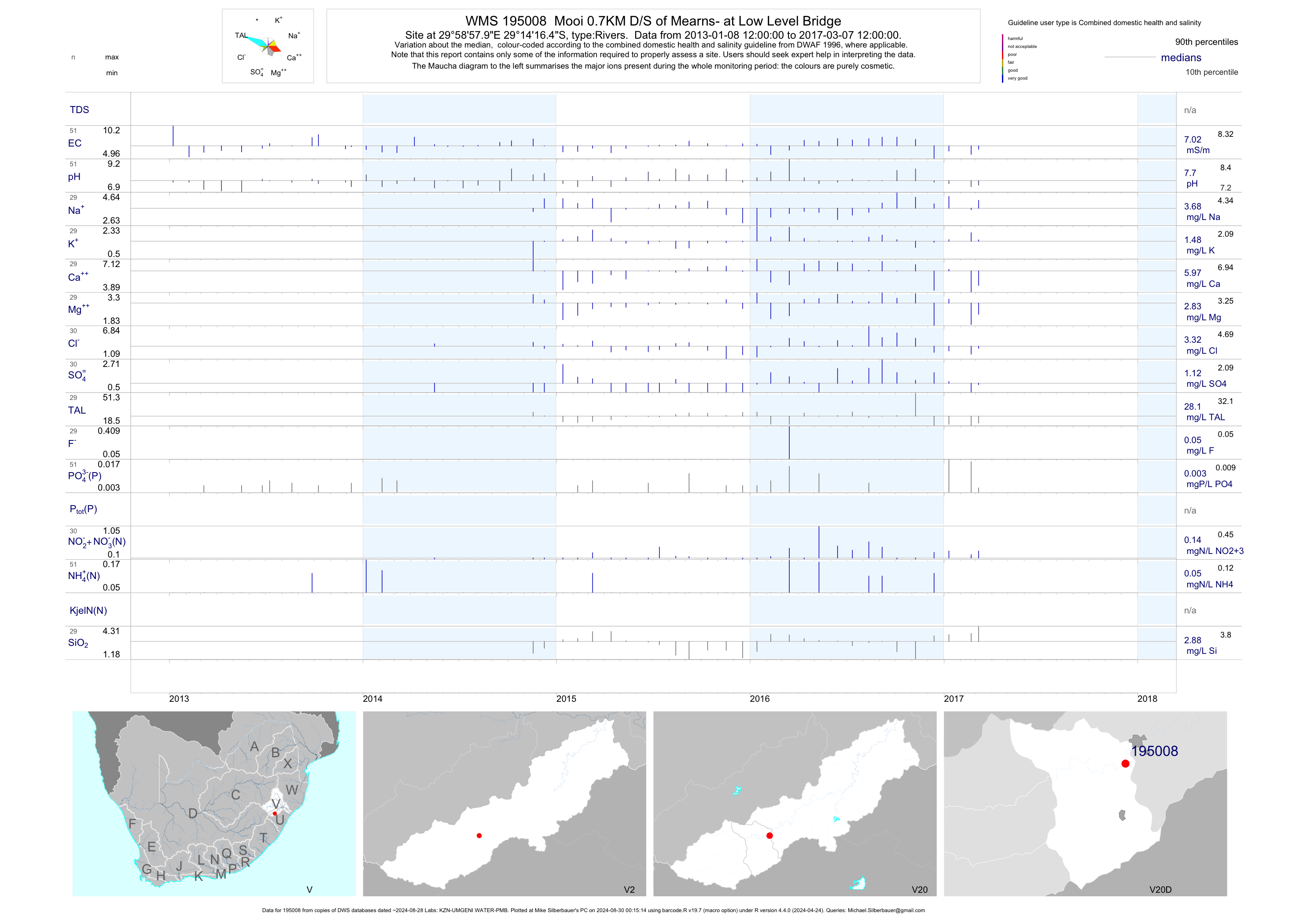
| V20 195008 | plot | data | Mooi 0.7KM D/S of Mearns- at Low Level Bridge | Rivers | 89 | 2013-01-08 | 2017-03-07 | 7 | 195008 | -29.23791 | 29.98277 |
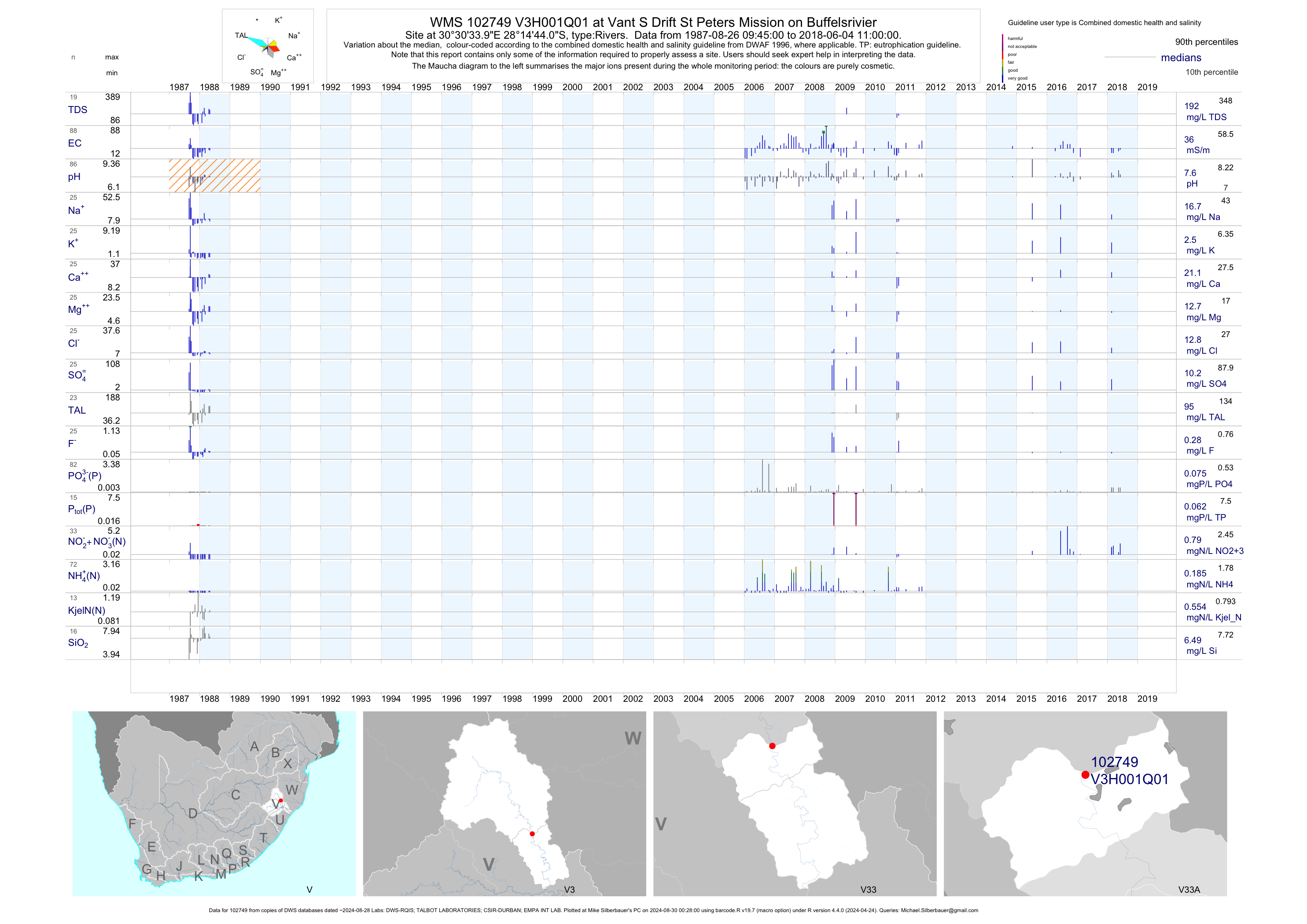
| V33 102749 | plot | data | at Vant S Drift St Peters Mission on Buffelsrivier | Rivers | 95 | 1987-08-26 | 2017-03-07 | 38 | V3H001 | -28.24556 | 30.50944 |
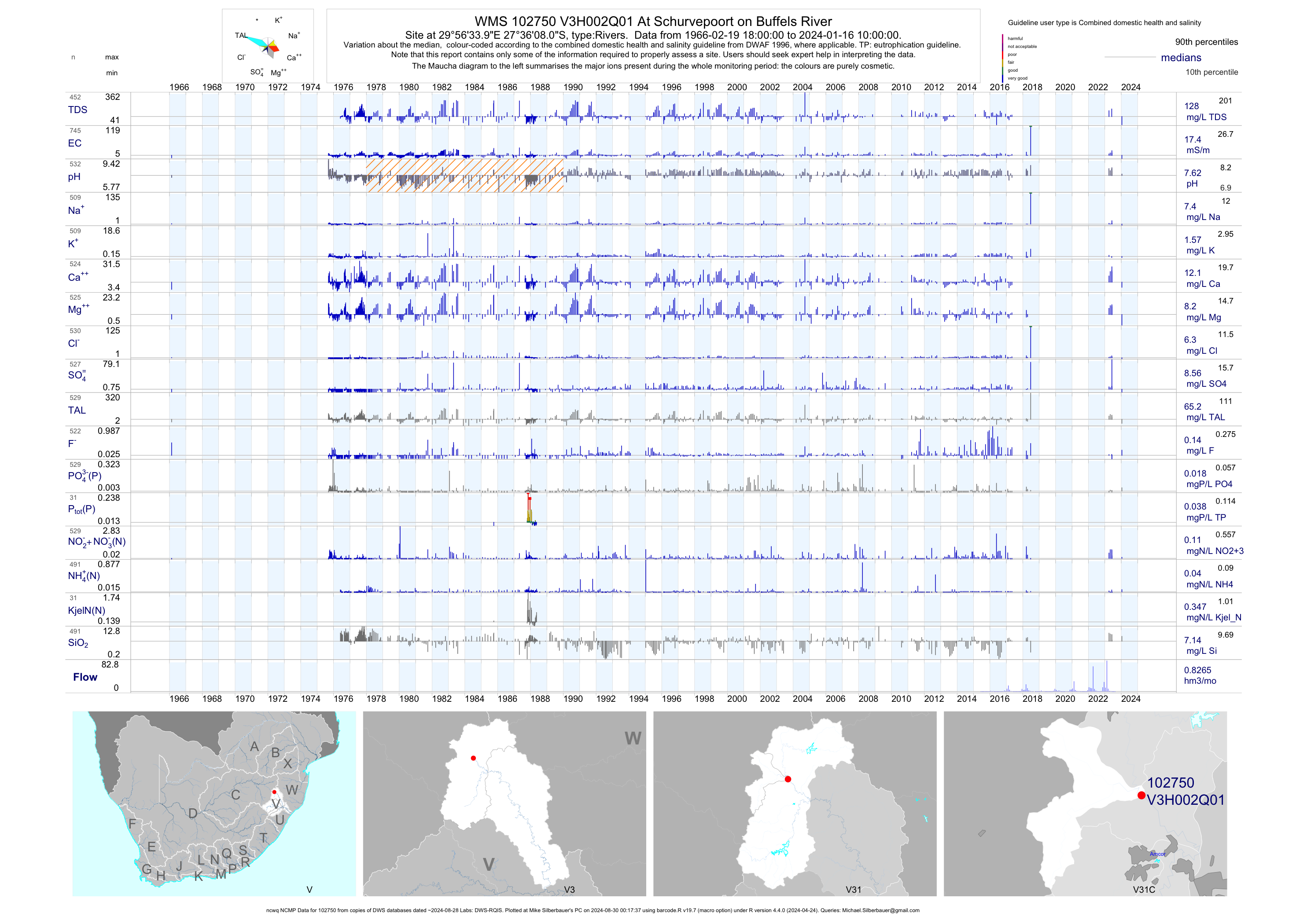
| V31 102750 | plot | data | At Schurvepoort on Buffels River (ncwq NCMP) | Rivers | 1205 | 1966-02-19 | 2018-06-26 | 17 | V3H002 | -27.60222 | 29.94278 |
| V31 102751 | n/a | n/a | At Ballengeich on Ngagane | Rivers | 52 | 1957-02-09 | 1957-12-05 | n/a | V3H003 | -27.92278 | 29.94944 |
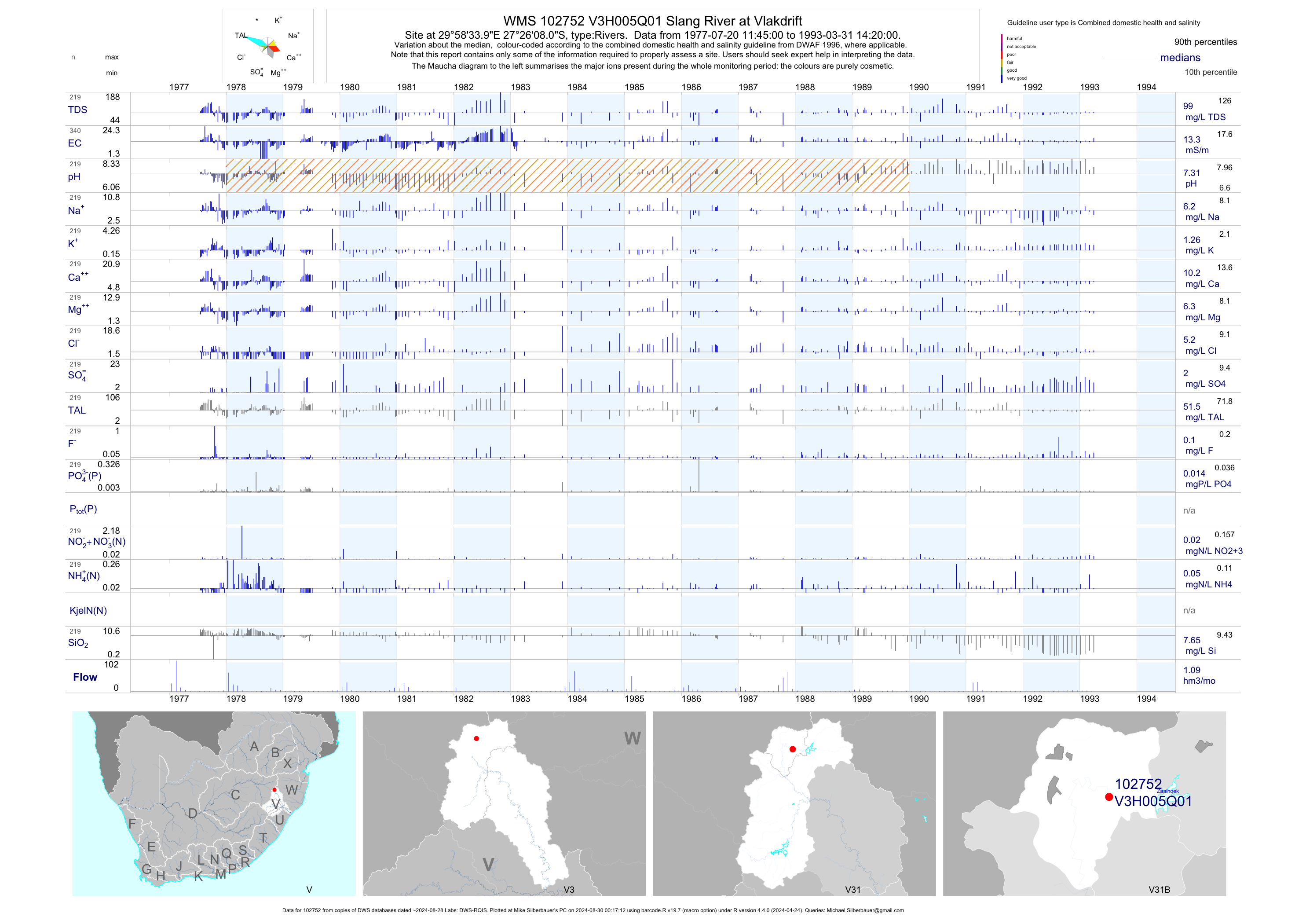
| V31 102752 | plot | data | Slang River at Vlakdrift | Rivers | 341 | 1977-07-20 | 1993-03-31 | 13 | V3H005 | -27.43556 | 29.97611 |
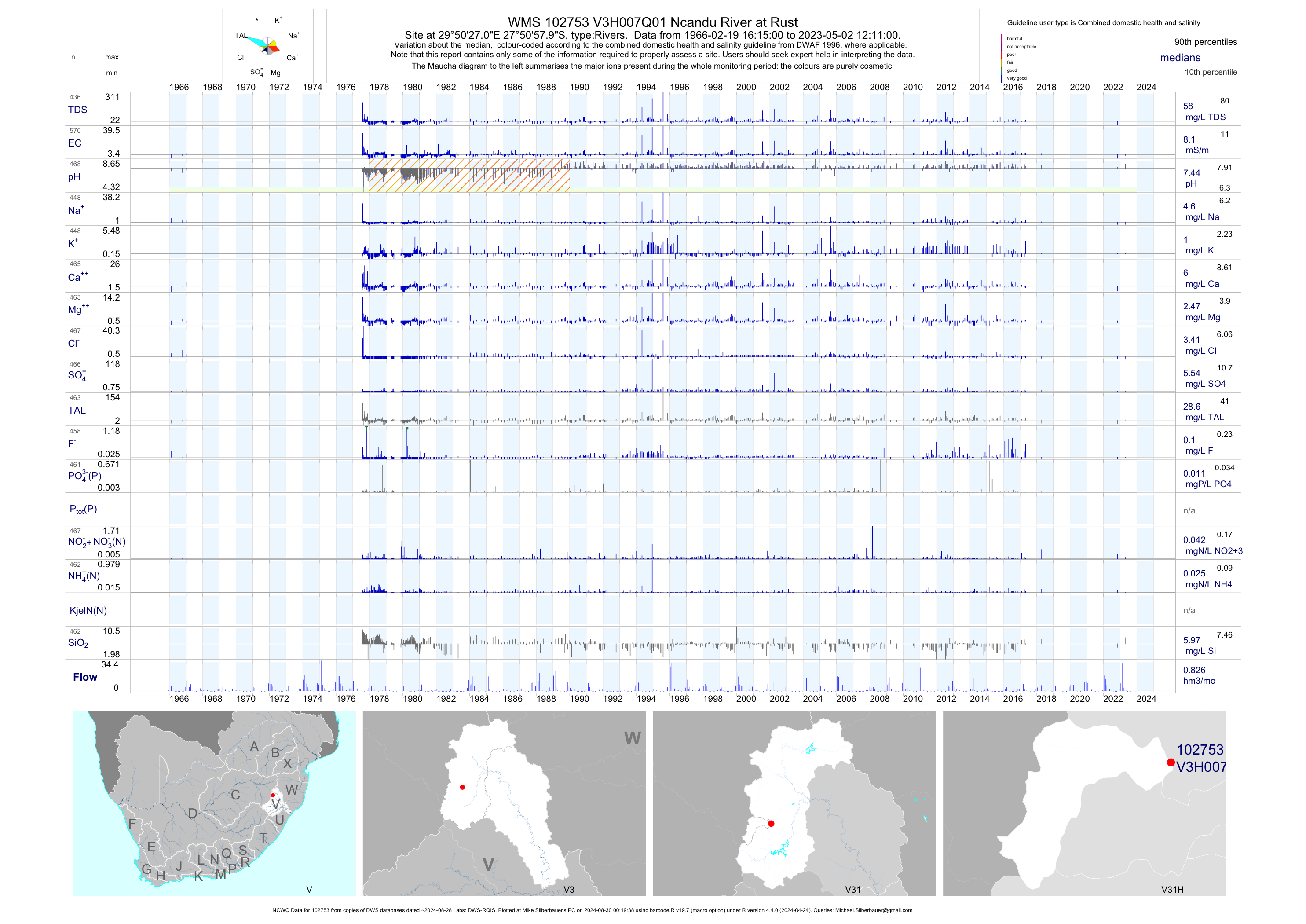
| V31 102753 | plot | data | Ncandu River at Rust (NCWQ) | Rivers | 571 | 1966-02-19 | 2018-04-19 | 8 | V3H007 | -27.84944 | 29.84083 |
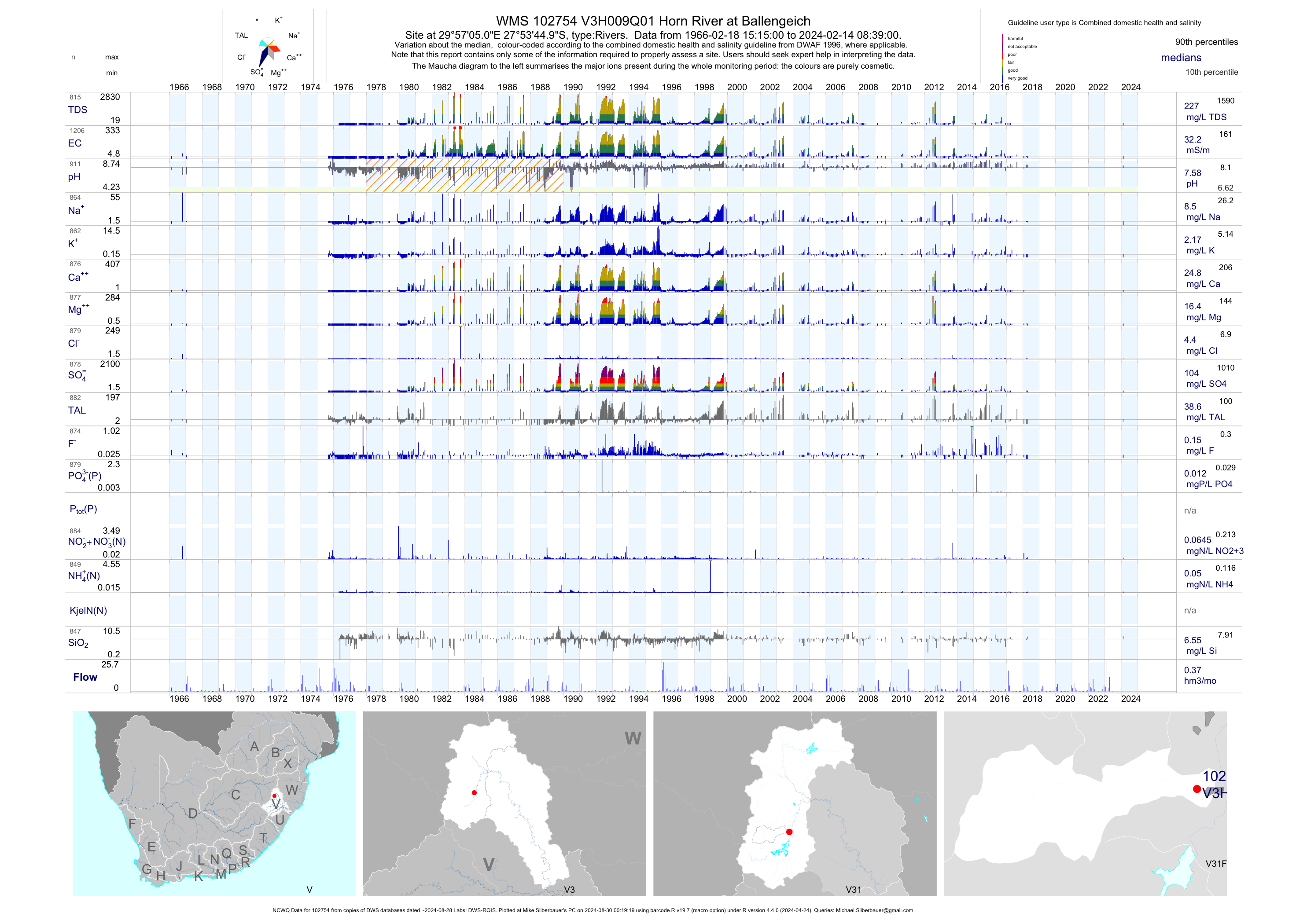
| V31 102754 | plot | data | Horn River at Ballengeich (NCWQ) | Rivers | 1207 | 1966-02-18 | 2018-04-20 | 32 | V3H009 | -27.89583 | 29.95139 |
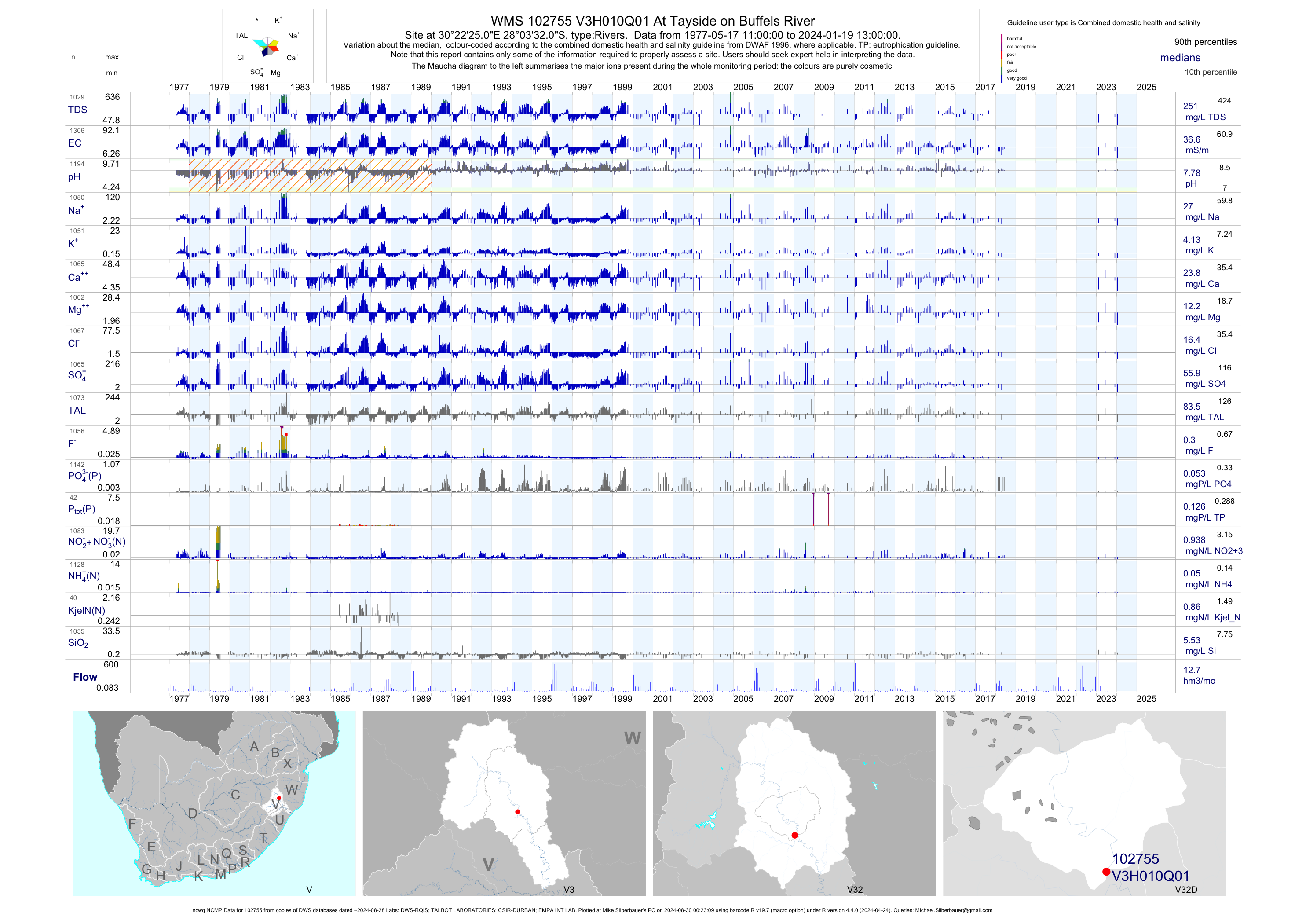
| V32 102755 | plot | data | At Tayside on Buffels River (ncwq NCMP) | Rivers | 1312 | 1977-05-17 | 2018-04-19 | 37 | V3H010 | -28.05889 | 30.37361 |
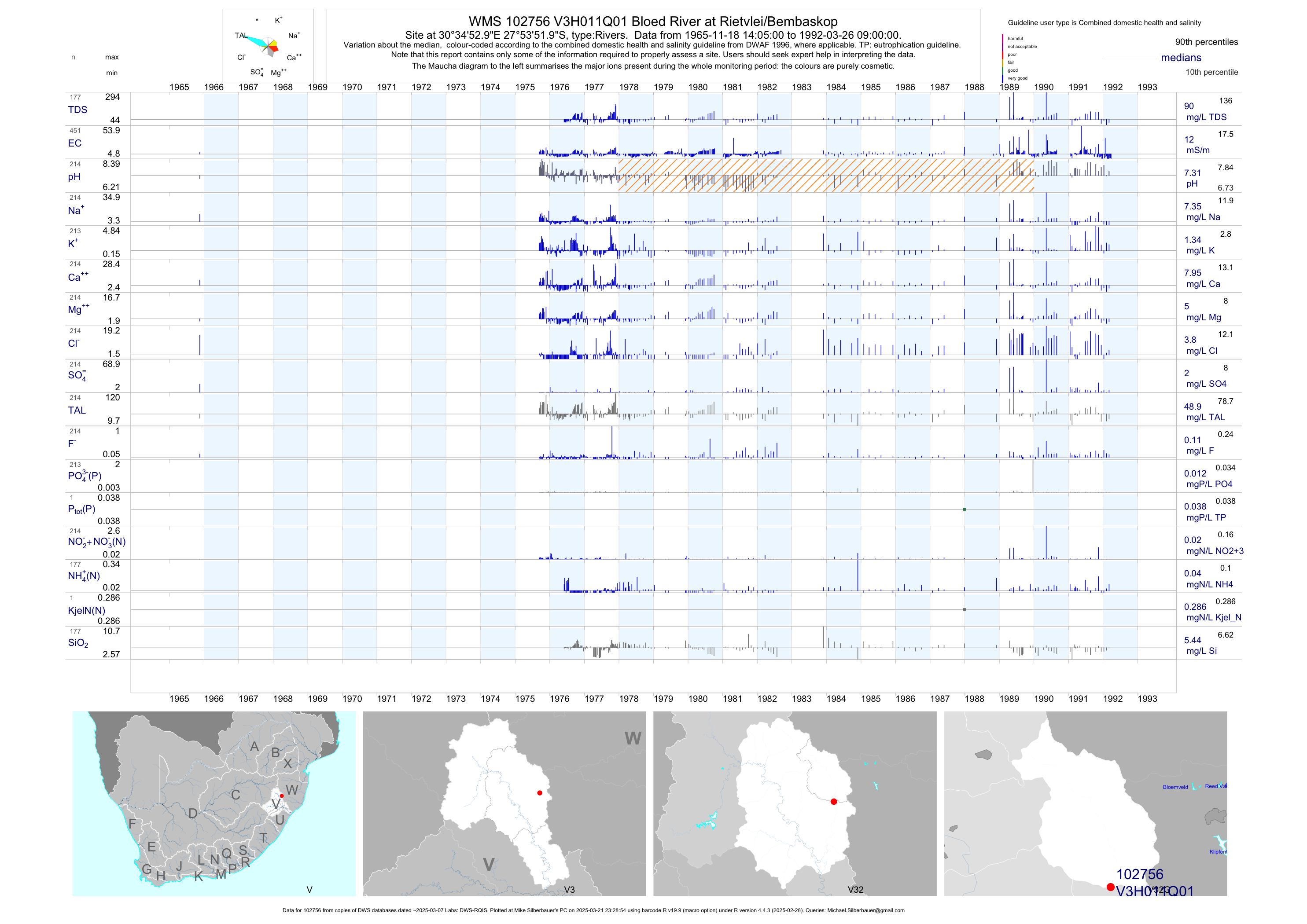
| V32 102756 | plot | data | Bloed River at Rietvlei/Bembaskop | Rivers | 451 | 1965-11-18 | 1992-03-26 | 12 | V3H011 | -27.89778 | 30.58139 |
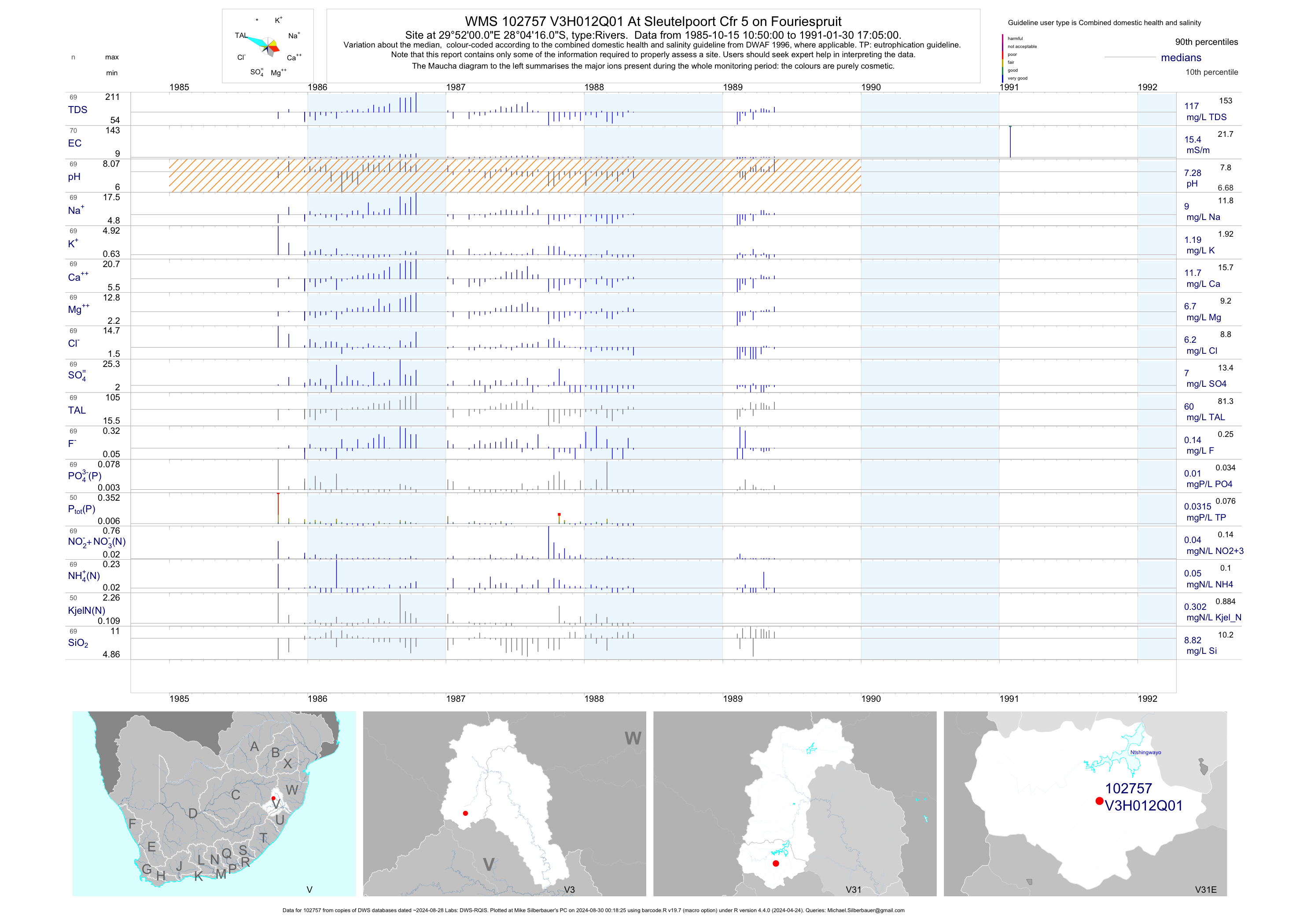
| V31 102757 | plot | data | At Sleutelpoort Cfr 5 on Fouriespruit | Rivers | 70 | 1985-10-15 | 1991-01-30 | 15 | V3H012 | -28.07111 | 29.86667 |
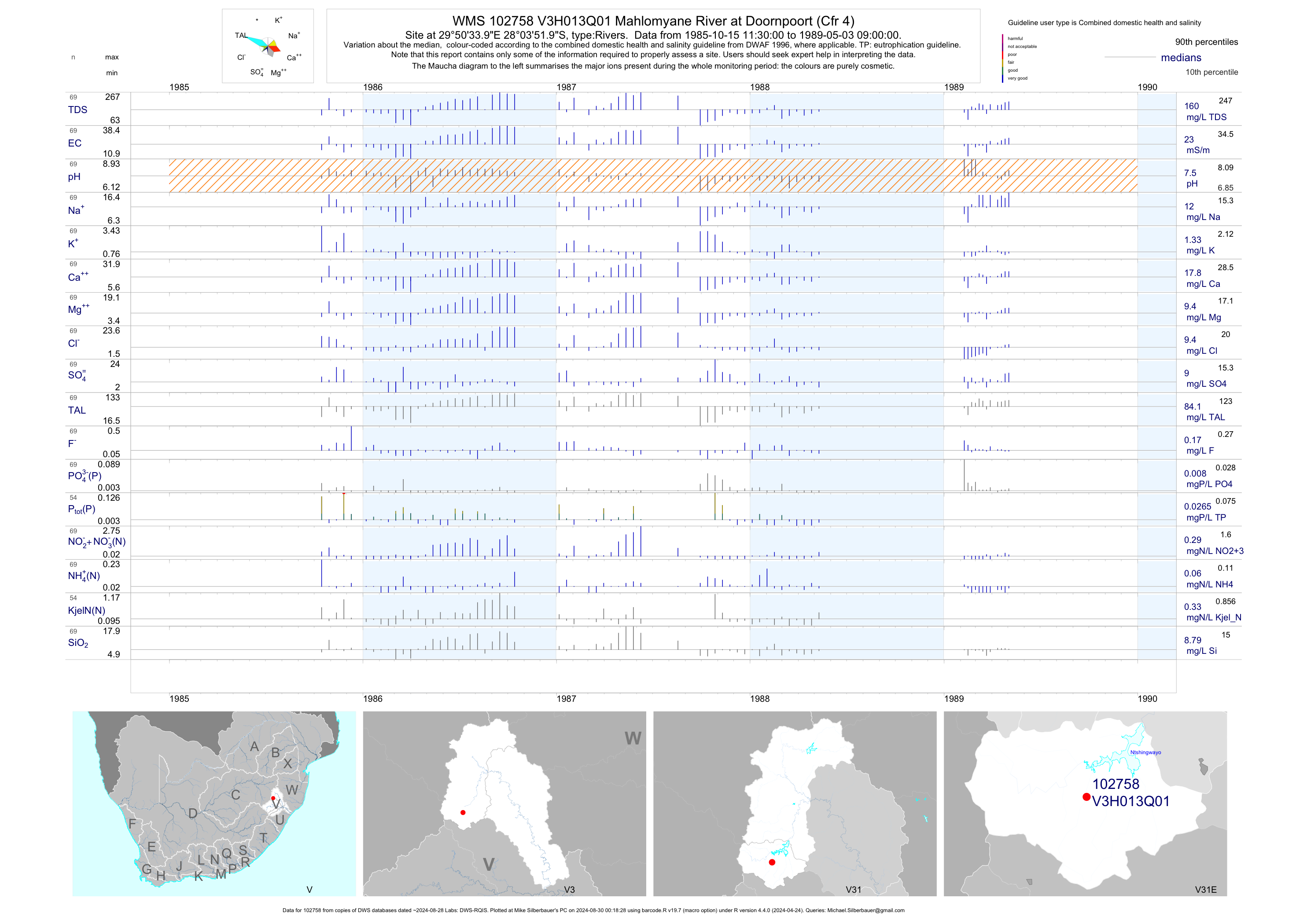
| V31 102758 | plot | data | Mahlomyane River at Doornpoort (Cfr 4) | Rivers | 69 | 1985-10-15 | 1989-05-03 | 23 | V3H013 | -28.06444 | 29.84278 |
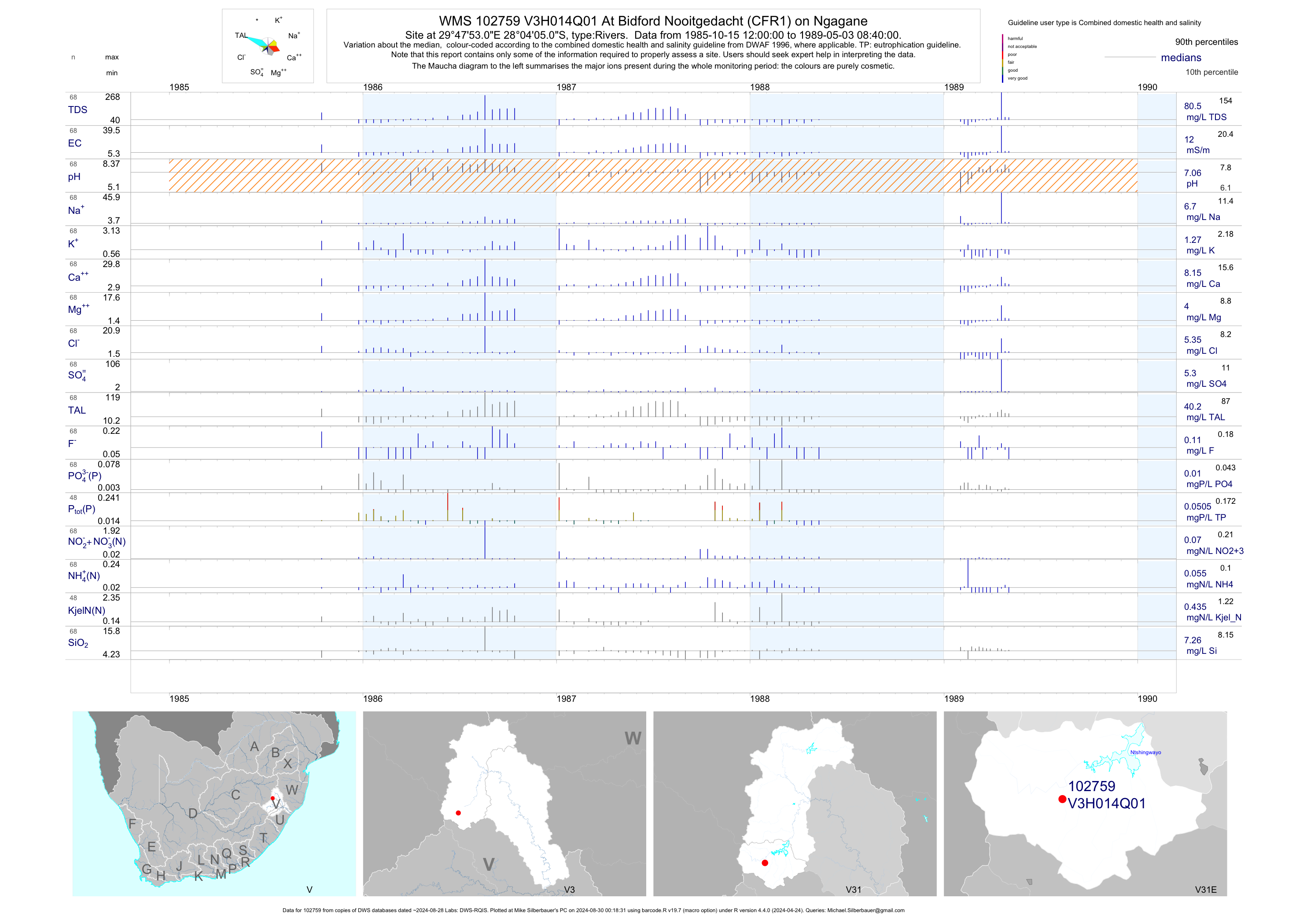
| V31 102759 | plot | data | At Bidford Nooitgedacht (CFR1) on Ngagane | Rivers | 68 | 1985-10-15 | 1989-05-03 | 12 | V3H014 | -28.06806 | 29.79806 |
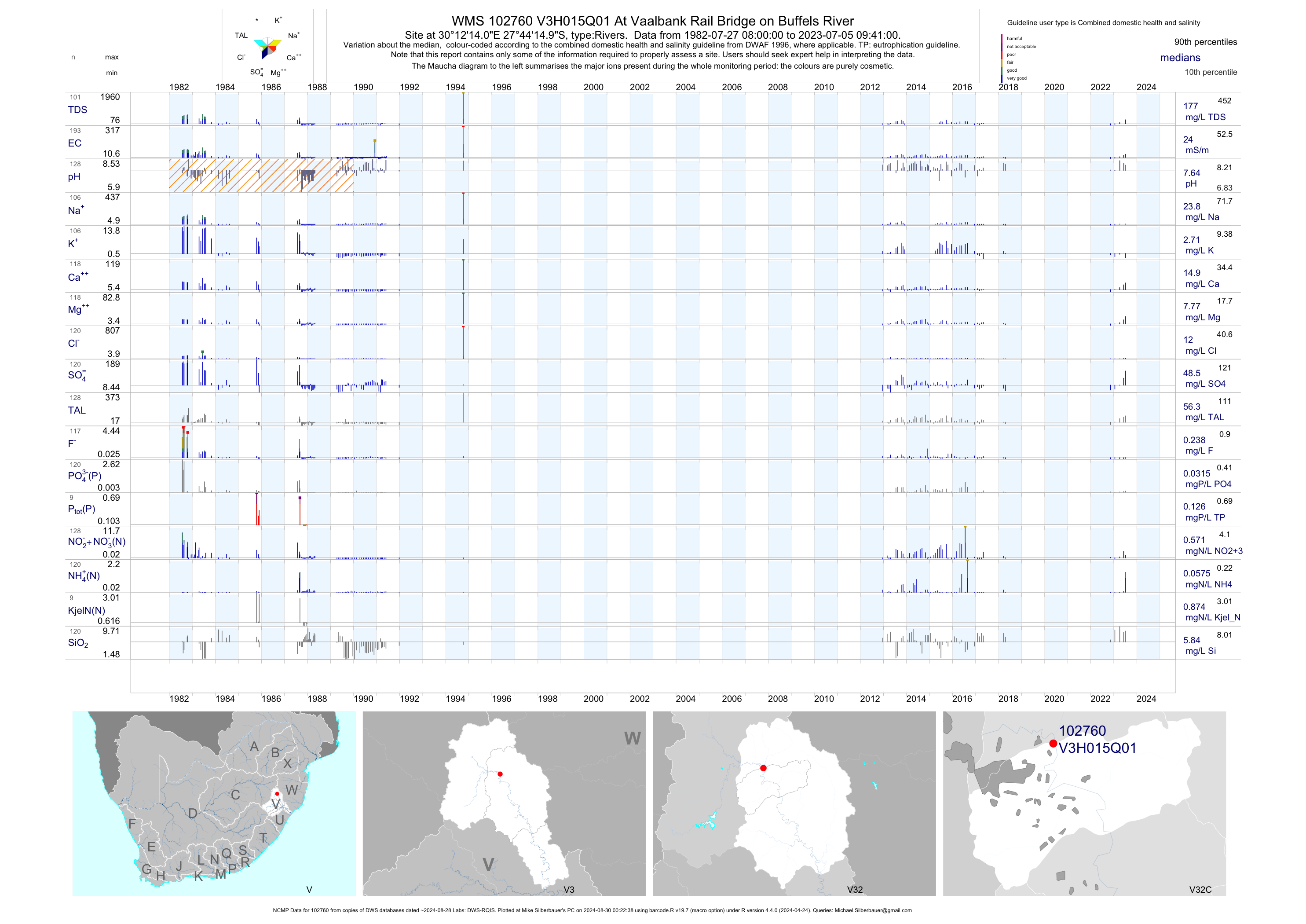
| V32 102760 | plot | data | At Vaalbank Rail Bridge on Buffels River (NCMP) | Rivers | 190 | 1982-07-27 | 2018-04-18 | 24 | V3H015 | -27.73750 | 30.20389 |
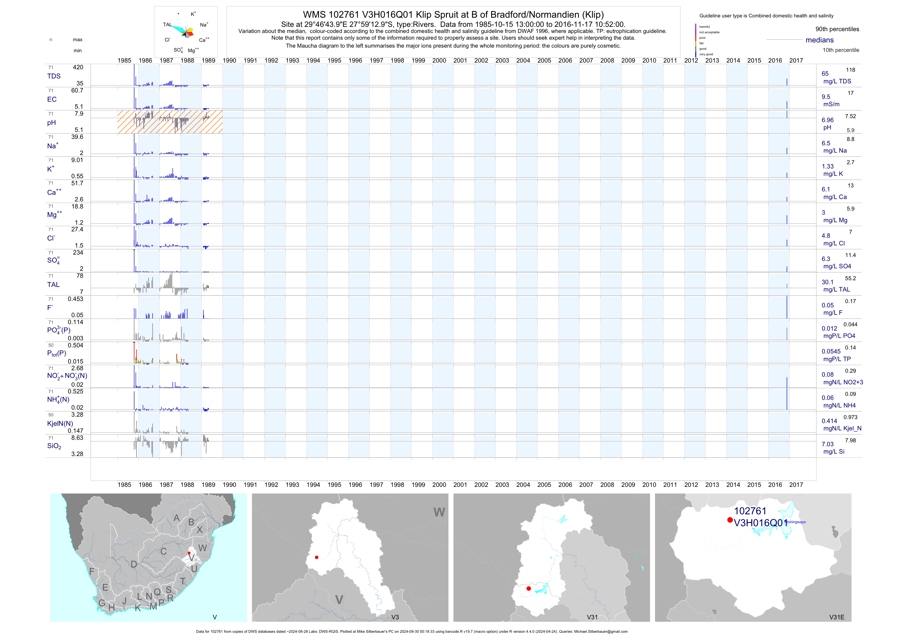
| V31 102761 | plot | data | Klip Spruit at B of Bradford/Normandien (Klip) | Rivers | 71 | 1985-10-15 | 2016-11-17 | 10 | V3H016 | -27.98694 | 29.77889 |
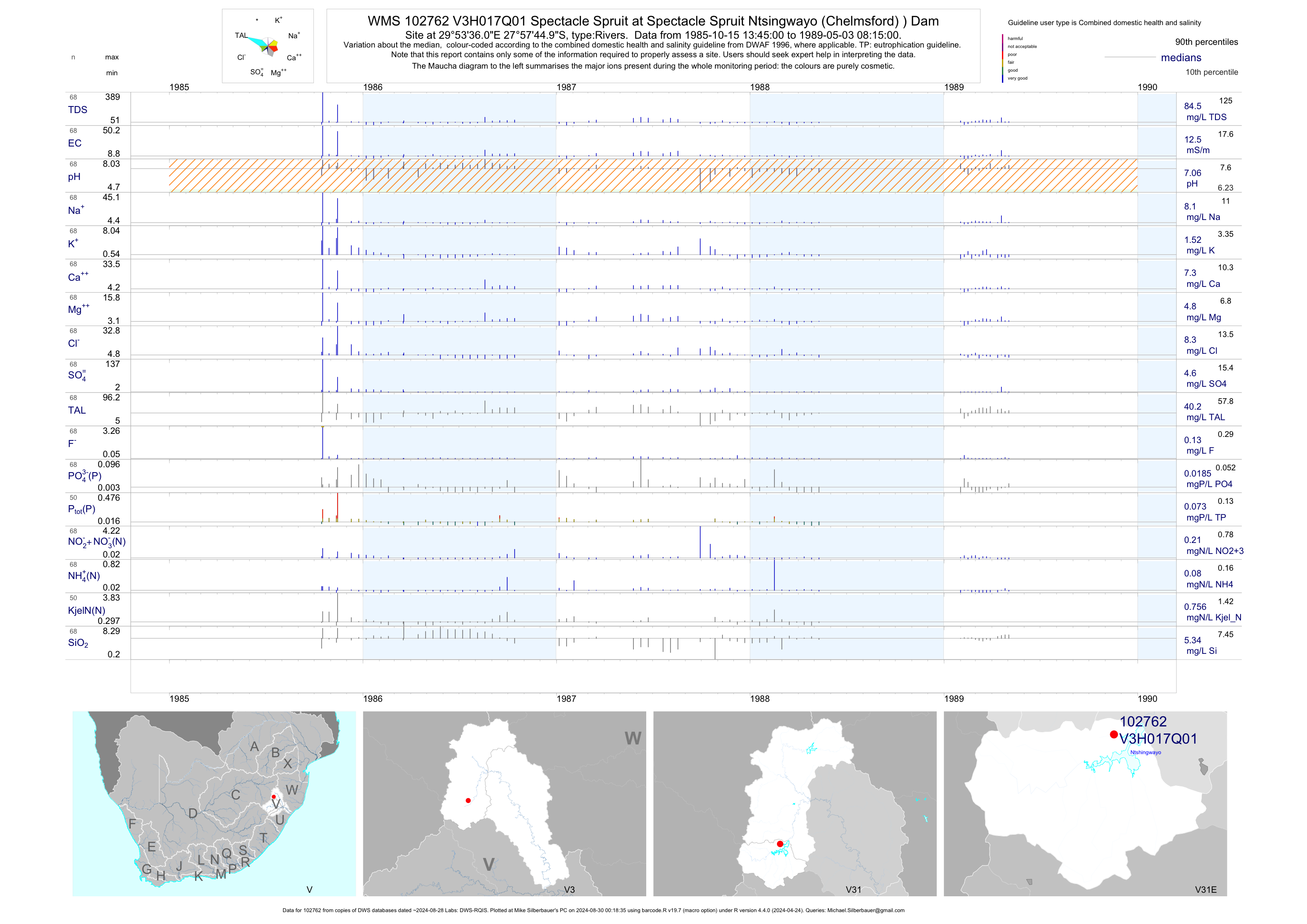
| V31 102762 | plot | data | Spectacle Spruit at Spectacle Spruit Ntsingwayo (Chelmsford) ) Dam | Rivers | 68 | 1985-10-15 | 1989-05-03 | 12 | V3H017 | -27.96250 | 29.89333 |
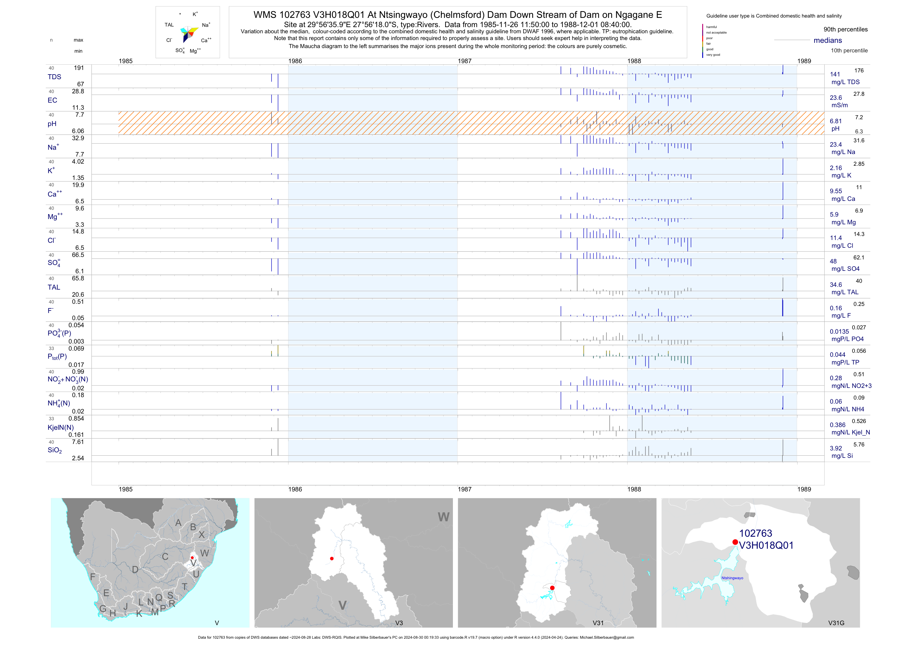
| V31 102763 | plot | data | At Ntsingwayo (Chelmsford) Dam Down Stream of Dam on Ngagane E | Rivers | 40 | 1985-11-26 | 1988-12-01 | 24 | V3H018 | -27.93833 | 29.94333 |
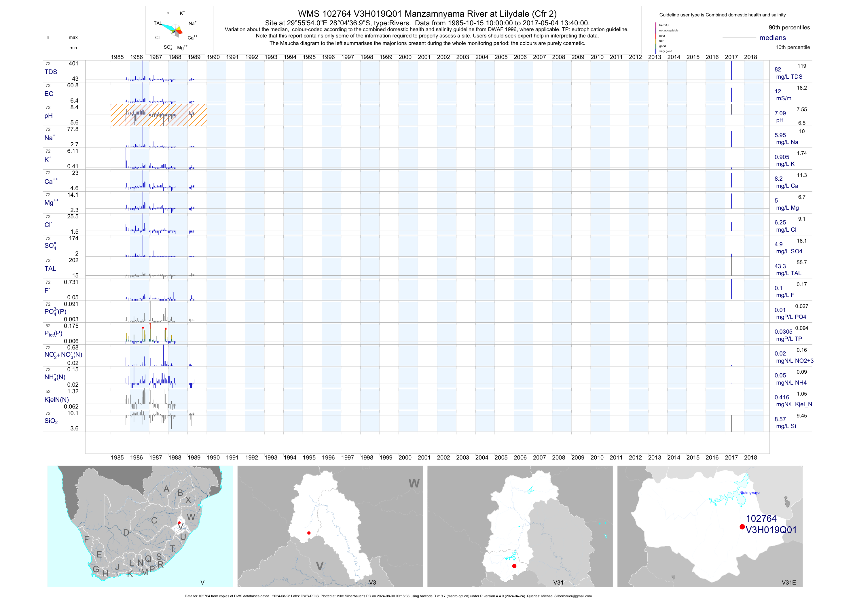
| V31 102764 | plot | data | Manzamnyama River at Lilydale (Cfr 2) | Rivers | 72 | 1985-10-15 | 2017-05-04 | 12 | V3H019 | -28.07694 | 29.93167 |
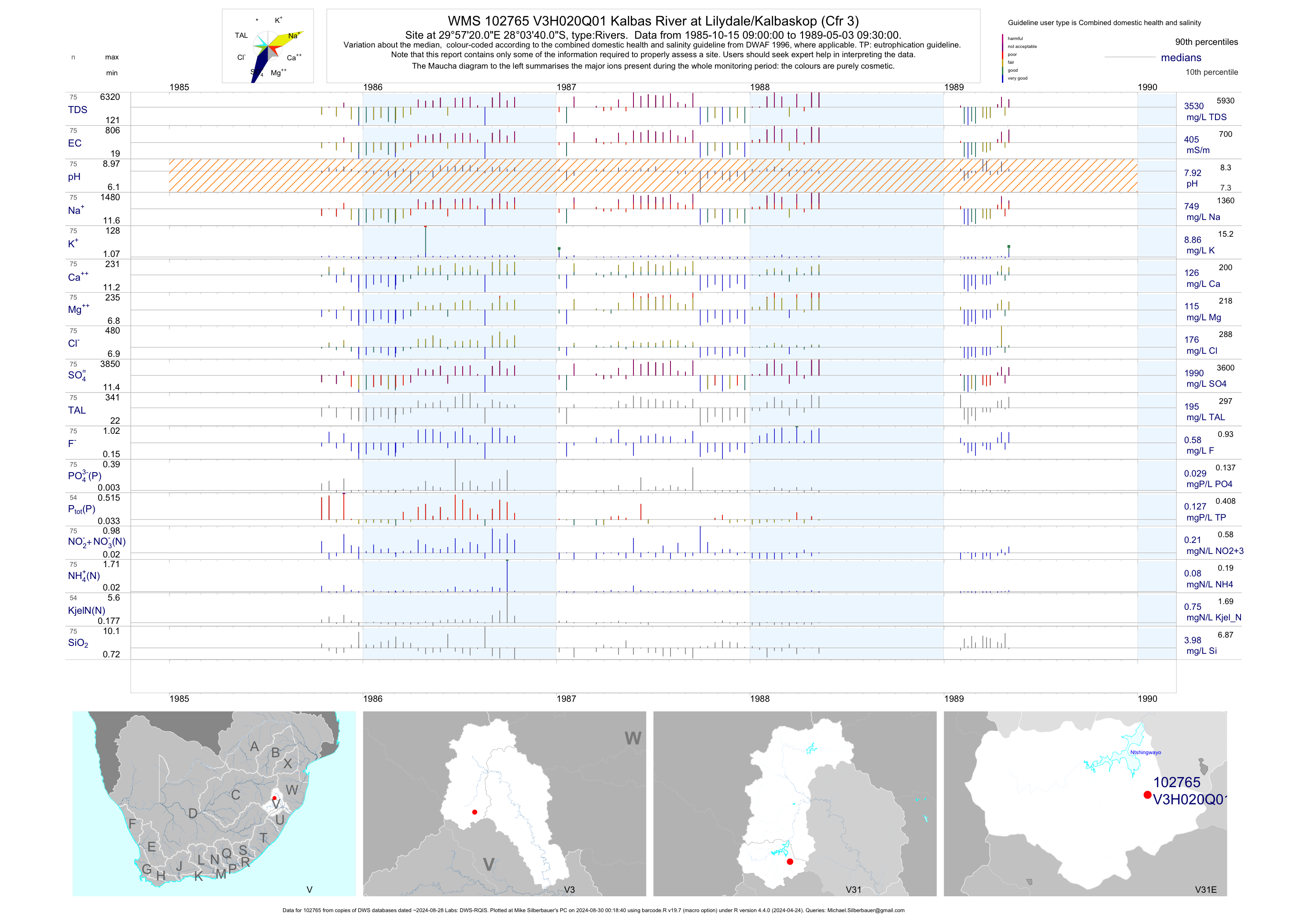
| V31 102765 | plot | data | Kalbas River at Lilydale/Kalbaskop (Cfr 3) | Rivers | 75 | 1985-10-15 | 1989-05-03 | 405 | V3H020 | -28.06111 | 29.95556 |
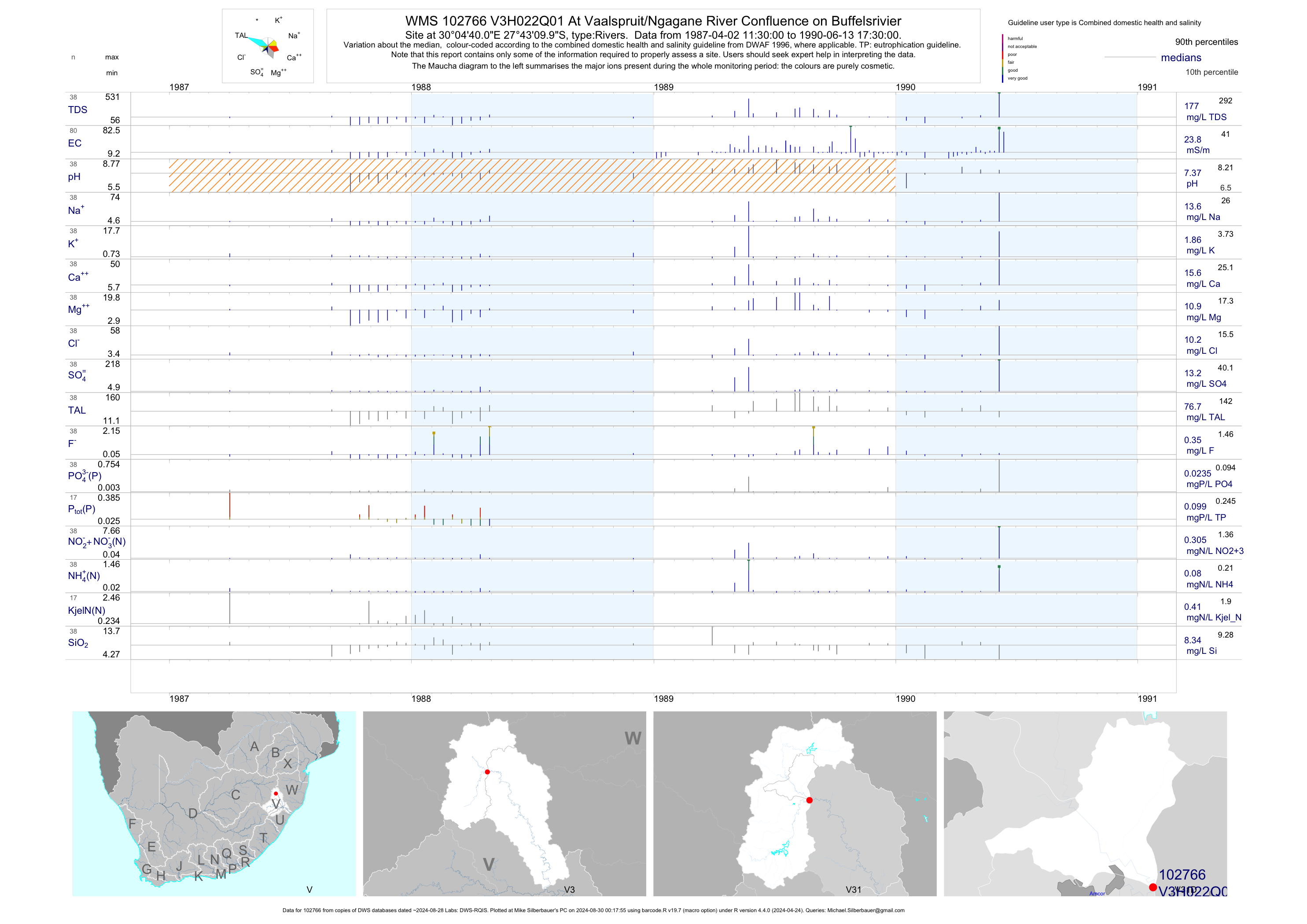
| V31 102766 | plot | data | At Vaalspruit/Ngagane River Confluence on Buffelsrivier | Rivers | 80 | 1987-04-02 | 1990-06-13 | 24 | V3H022 | -27.71944 | 30.07778 |
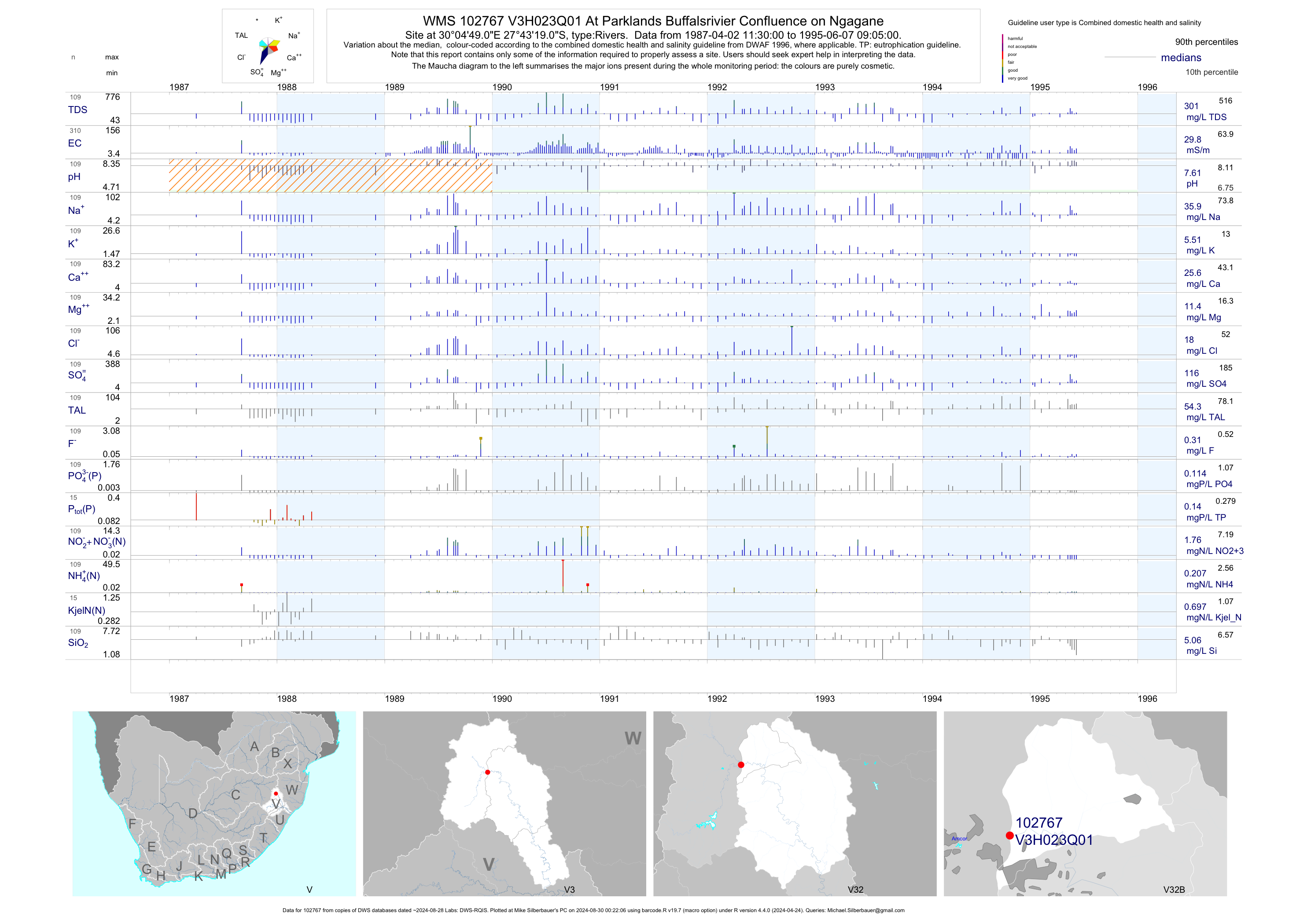
| V32 102767 | plot | data | At Parklands Buffalsrivier Confluence on Ngagane | Rivers | 310 | 1987-04-02 | 1995-06-07 | 30 | V3H023 | -27.72194 | 30.08028 |
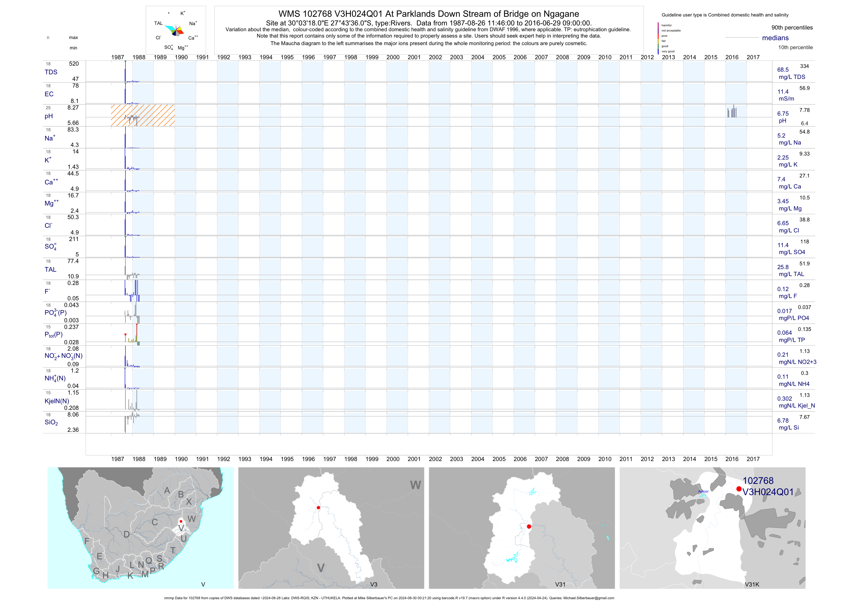
| V31 102768 | plot | data | At Parklands Down Stream of Bridge on Ngagane (nmmp) | Rivers | 39 | 1987-08-26 | 2016-06-29 | 11 | V3H024 | -27.72667 | 30.05500 |
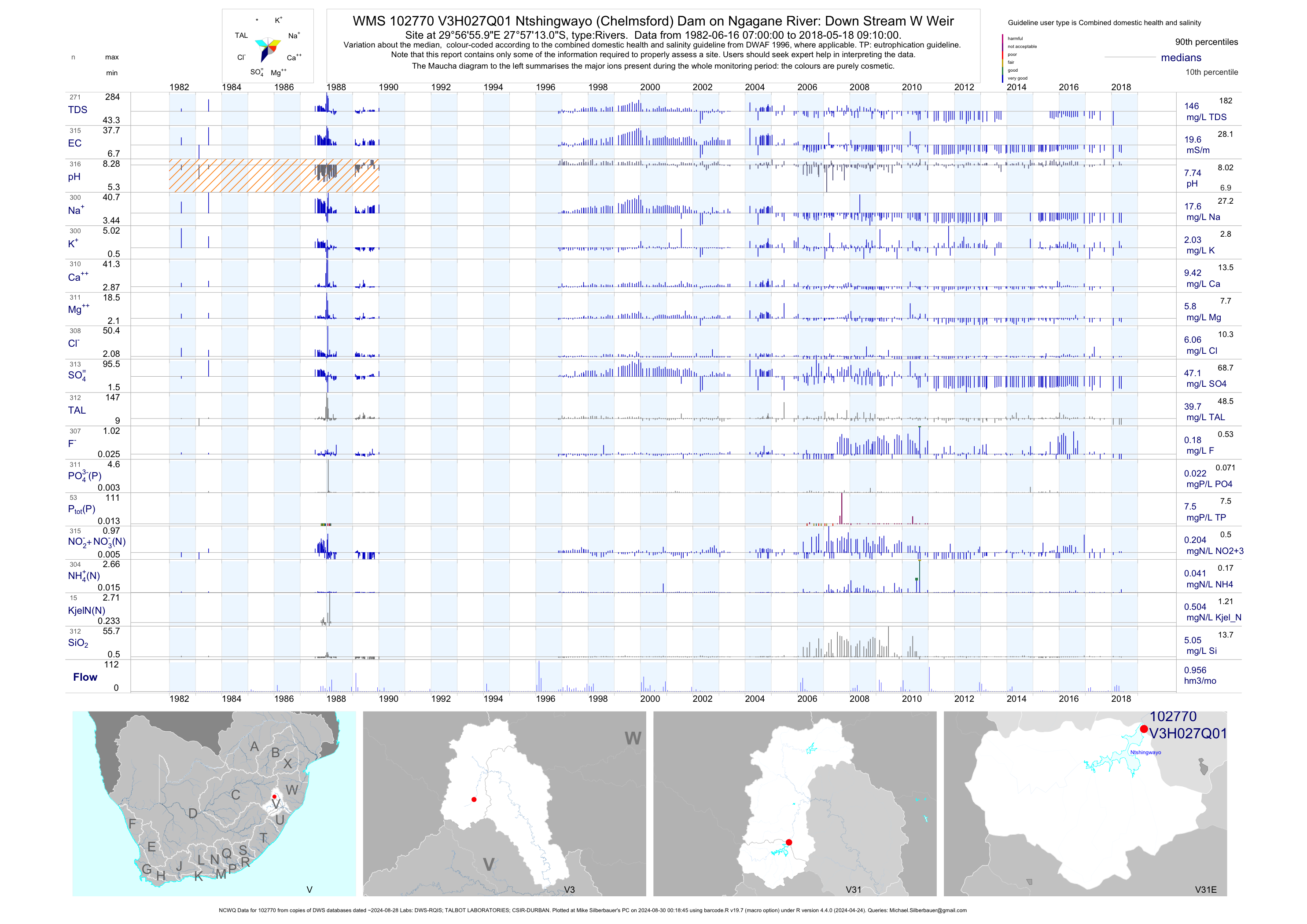
| V31 102770 | plot | data | Ntshingwayo (Chelmsford) Dam on Ngagane River: Down Stream W Weir (NCWQ) | Rivers | 321 | 1982-06-16 | 2018-05-18 | 20 | V3H027 | -27.95361 | 29.94889 |
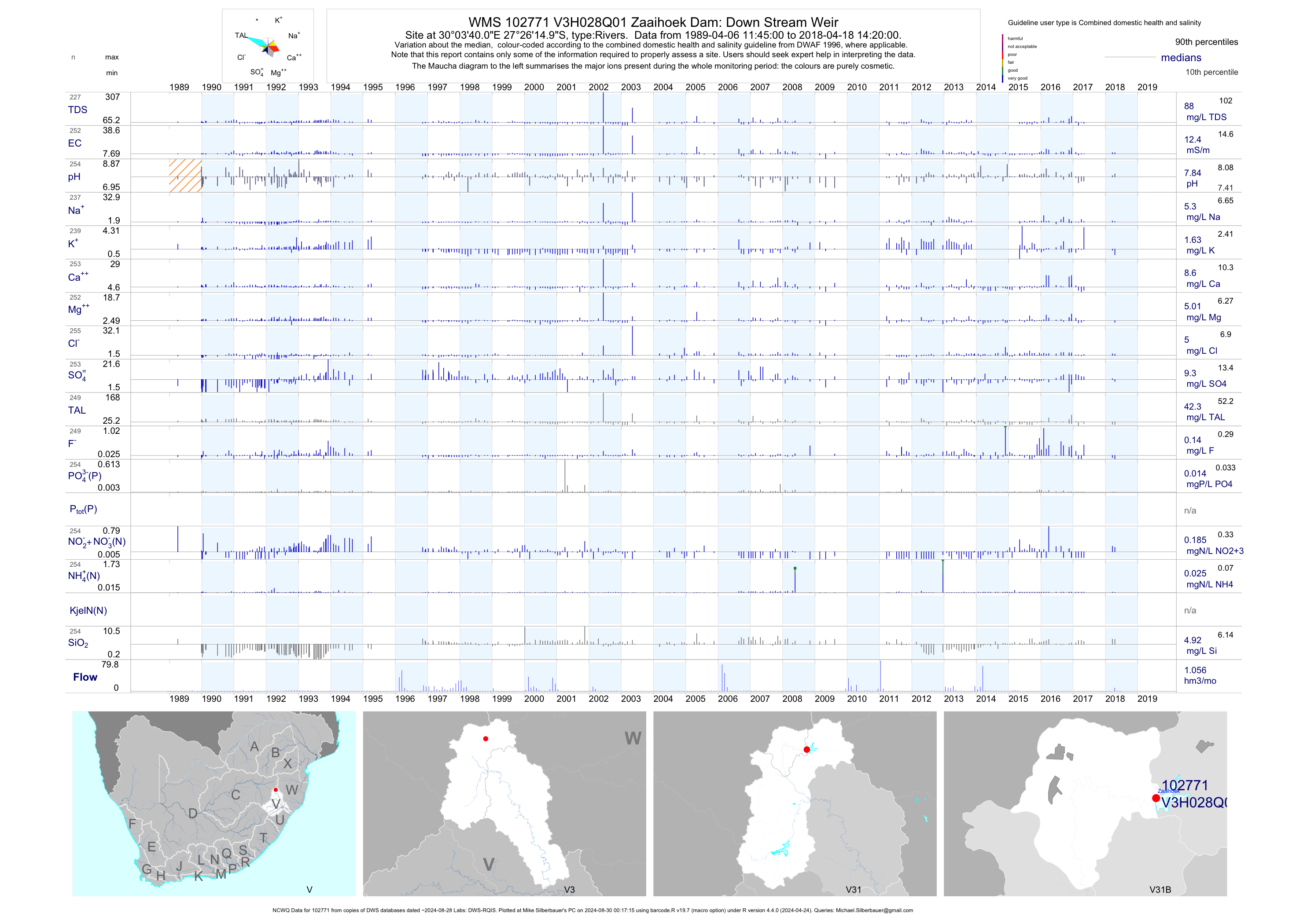
| V31 102771 | plot | data | Zaaihoek Dam: Down Stream Weir (NCWQ) | Rivers | 256 | 1989-04-06 | 2018-04-18 | 12 | V3H028 | -27.43750 | 30.06111 |
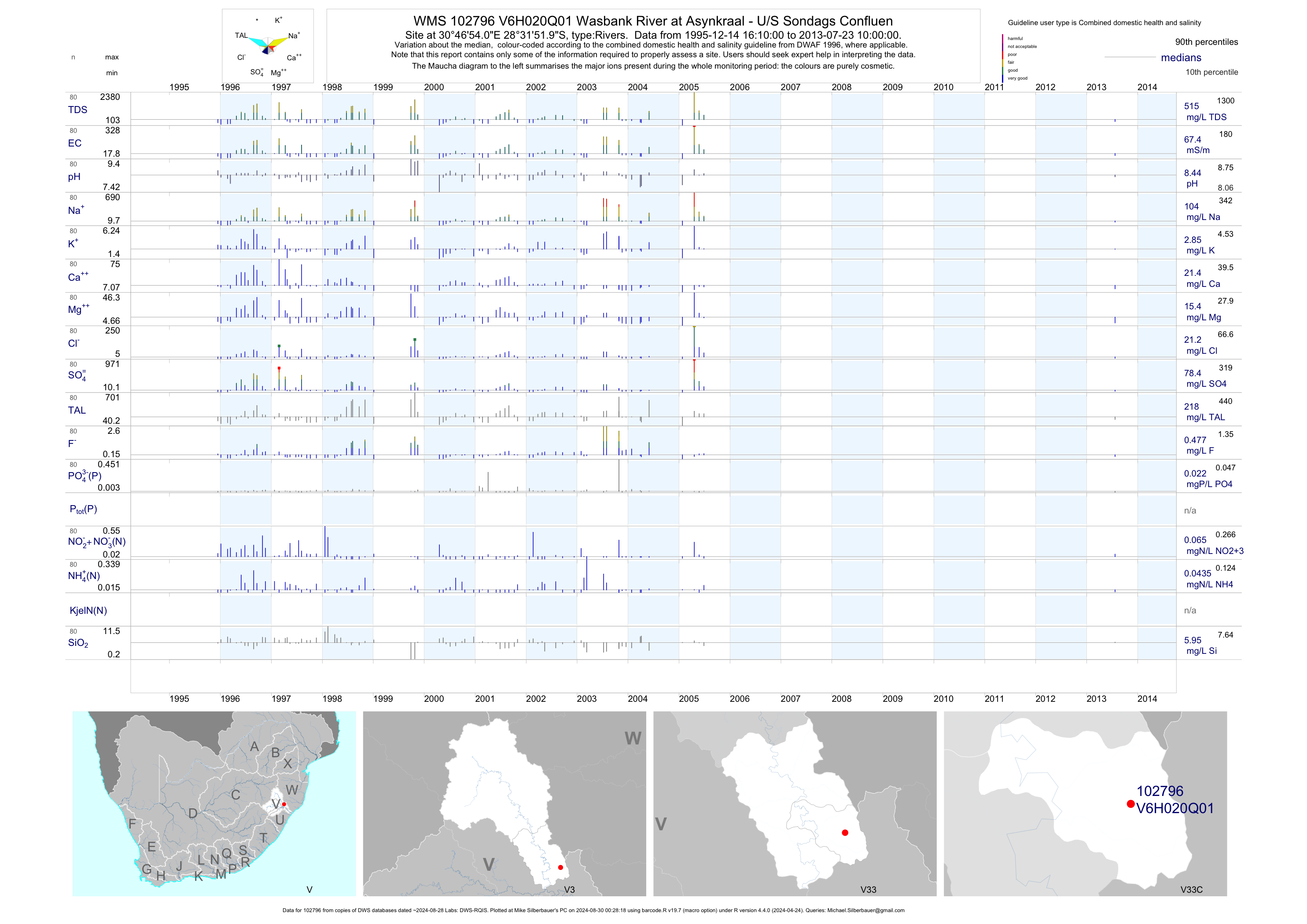
| V33 102796 | plot | data | Wasbank River at Asynkraal - U/S Sondags Confluen | Rivers | 163 | 1995-12-14 | 2013-07-23 | 67 | V6H020 | -28.53111 | 30.78167 |
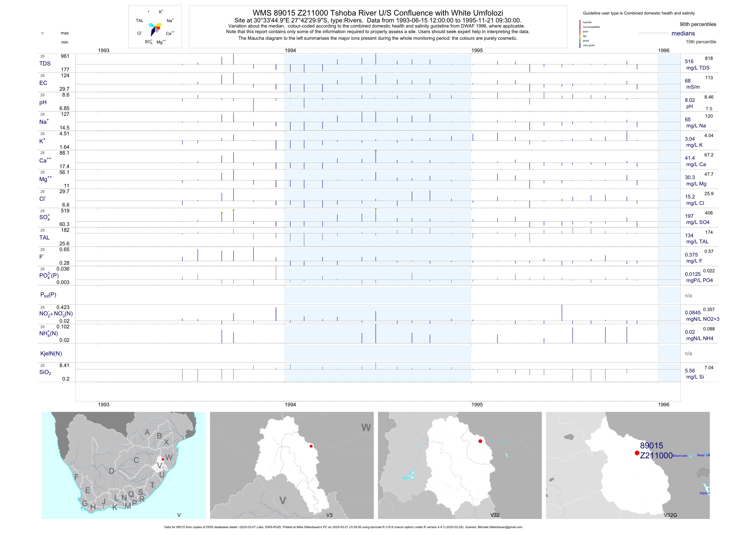
| V32 89015 | plot | data | Tshoba River U/S Confluence with White Umfolozi | Rivers | 52 | 1993-06-15 | 1995-11-21 | 68 | Z211000 | -27.70833 | 30.56250 |
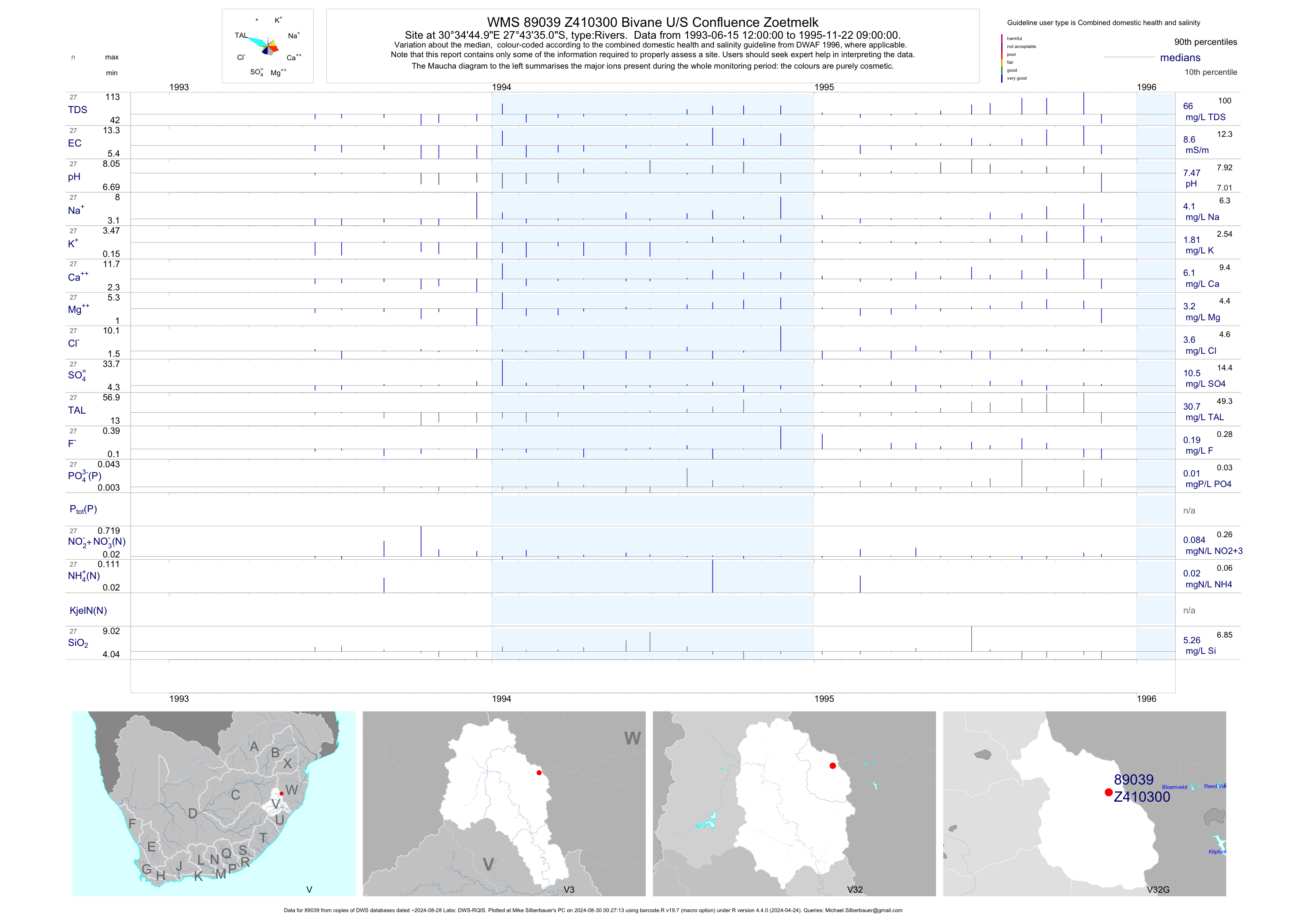
| V32 89039 | plot | data | Bivane U/S Confluence Zoetmelk | Rivers | 51 | 1993-06-15 | 1995-11-22 | 9 | Z410300 | -27.72639 | 30.57917 |
| V32 187697 | plot | data | #9 Bannockburn downstream Decant | Rivers | 57 | 2003-11-25 | 2015-04-23 | 95 | 187697 | -28.15911 | 30.18347 |
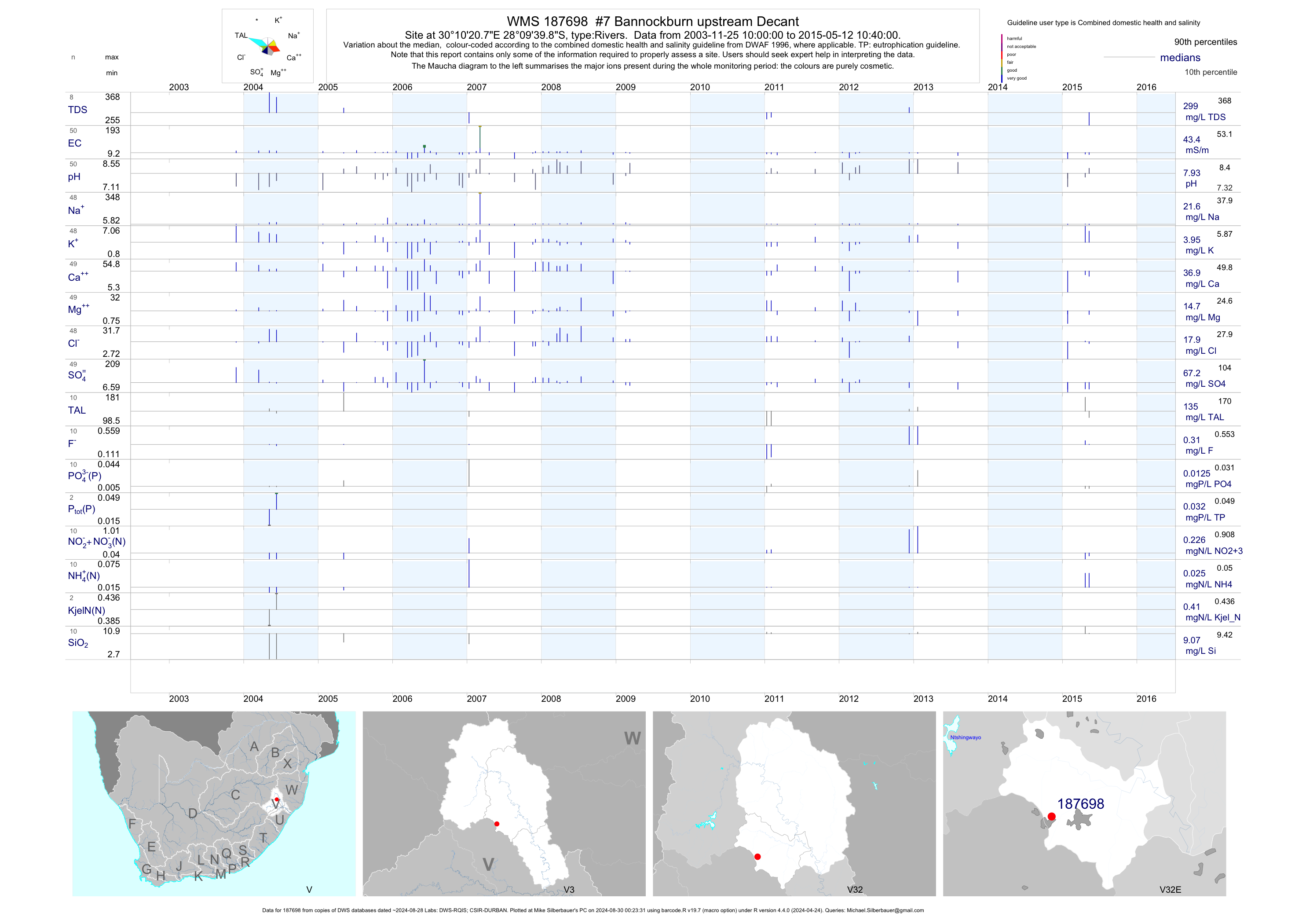
| V32 187698 | plot | data | #7 Bannockburn upstream Decant | Rivers | 58 | 2003-11-25 | 2015-05-12 | 43 | 187698 | -28.16106 | 30.17244 |
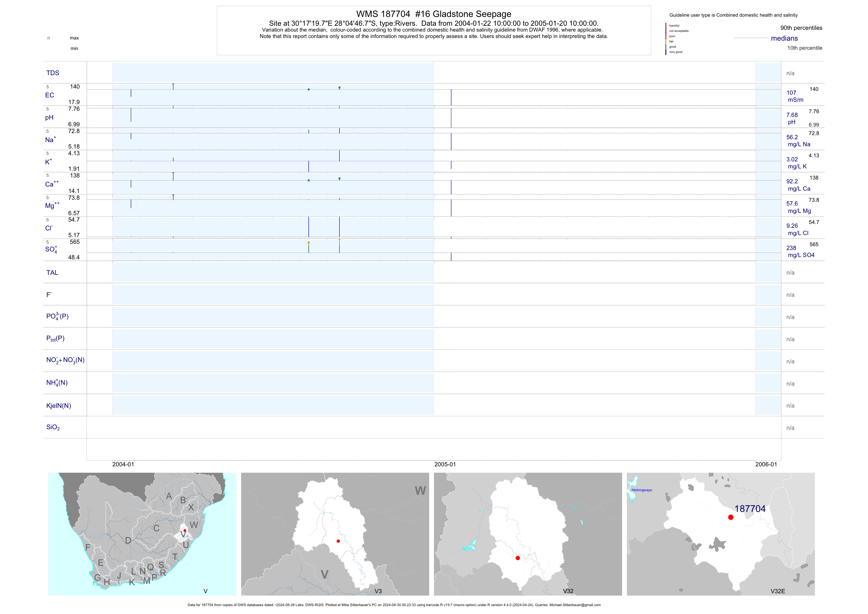
| V32 187704 | plot | data | #16 Gladstone Seepage | Rivers | 8 | 2004-01-22 | 2005-01-20 | 107 | 187704 | -28.07964 | 30.28881 |
| V32 187706 | plot | data | #18 Gladstone upstream of Gladstone Seepage | Rivers | 47 | 2003-11-25 | 2014-08-12 | 79 | 187706 | -28.07139 | 30.28603 |
| V31 187707 | plot | data | #24 Horn River Down Stream of Natal Coal Exploration | Rivers | 92 | 2003-11-25 | 2017-11-09 | 21 | 187707 | -27.89567 | 29.88058 |
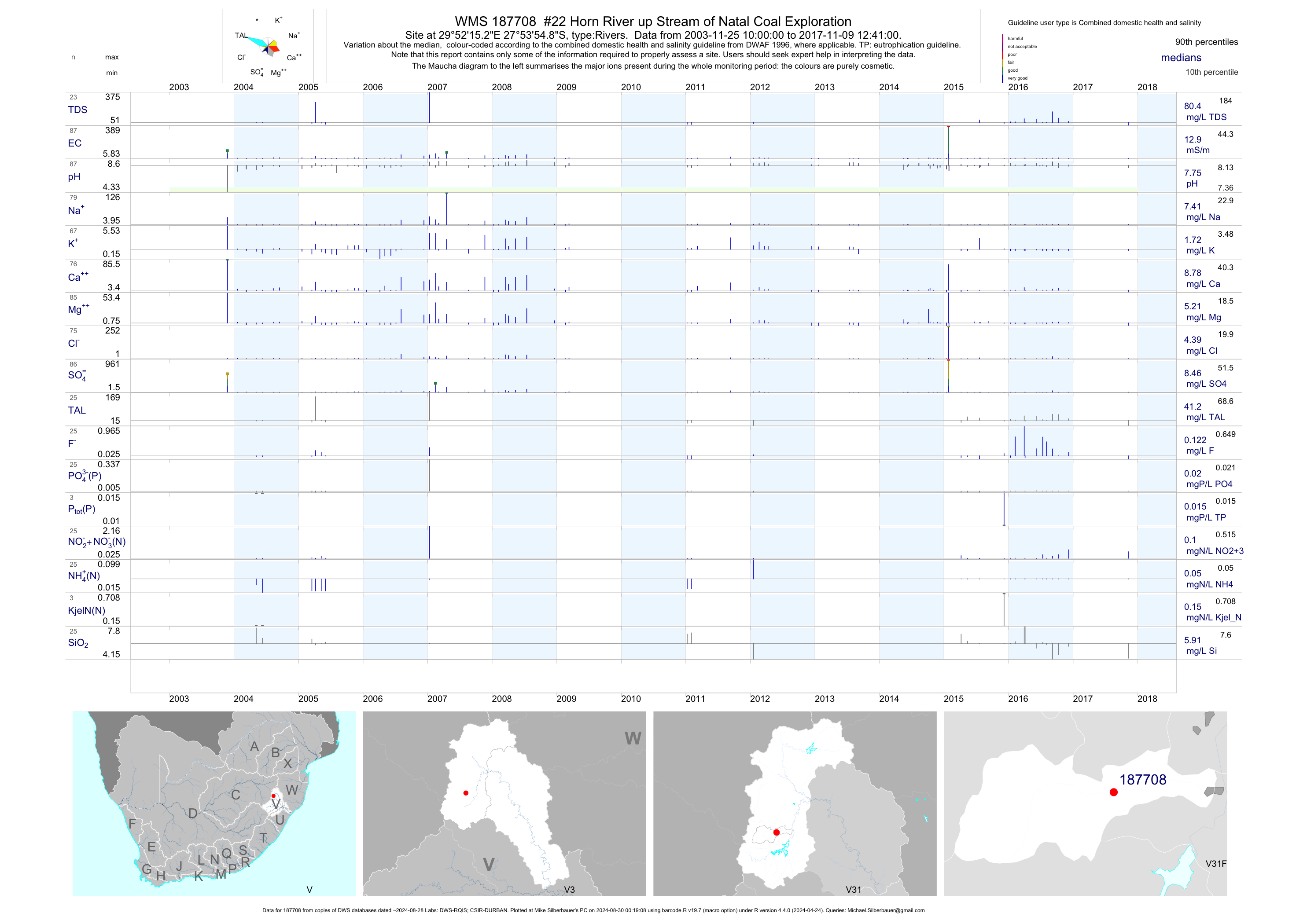
| V31 187708 | plot | data | #22 Horn River up Stream of Natal Coal Exploration | Rivers | 96 | 2003-11-25 | 2017-11-09 | 13 | 187708 | -27.89858 | 29.87089 |
| V32 187711 | plot | data | #25 Klip Rand Kliprand Dam on Tributary of Mzinyashana | Rivers | 74 | 2003-11-25 | 2016-07-13 | 33 | 187711 | -27.99717 | 30.15622 |
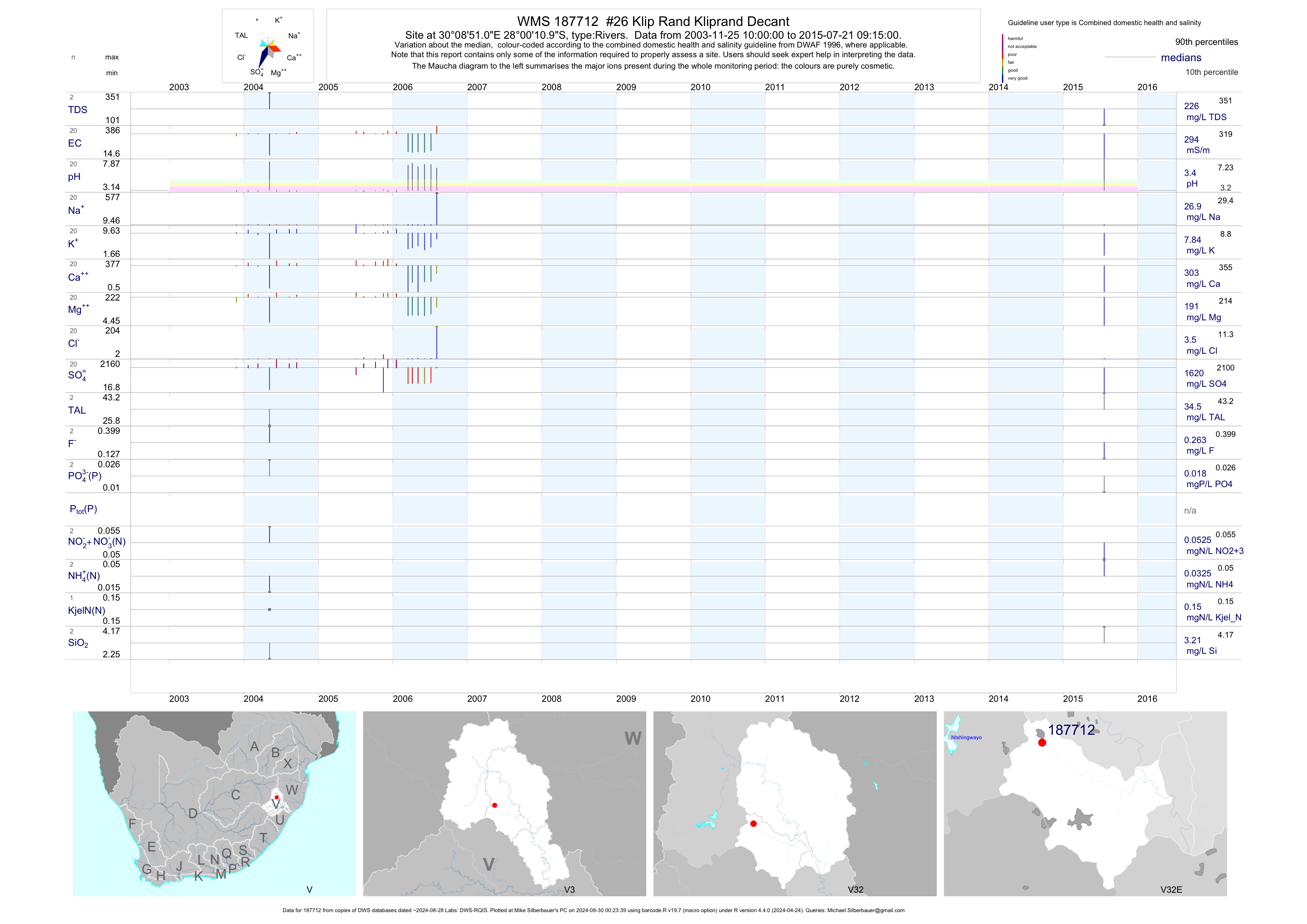
| V32 187712 | plot | data | #26 Klip Rand Kliprand Decant | Rivers | 26 | 2003-11-25 | 2015-07-21 | 294 | 187712 | -28.00303 | 30.14753 |
| V32 187714 | plot | data | #13 Dalry Down Stream of Corby Rock | Rivers | 41 | 2003-11-25 | 2014-06-05 | 108 | 187714 | -28.13872 | 30.38067 |
| V32 187715 | plot | data | #14 Corby Rock upstream of Corby Rock downstream of Dam | Rivers | 51 | 2003-11-25 | 2014-06-05 | 88 | 187715 | -28.15611 | 30.38333 |
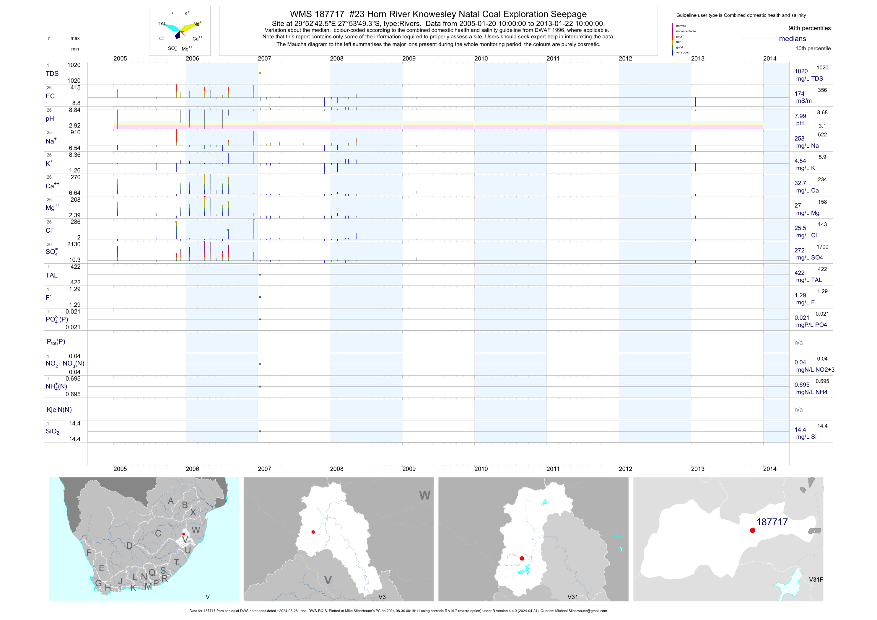
| V31 187717 | plot | data | #23 Horn River Knowesley Natal Coal Exploration Seepage | Rivers | 26 | 2005-01-20 | 2013-01-22 | 174 | 187717 | -27.89703 | 29.87850 |
| V32 187719 | plot | data | #21 Pietersdale of Ignusdale downstream of NNC2 and NNC3 | Rivers | 55 | 2003-11-25 | 2016-12-09 | 82 | 187719 | -28.04022 | 30.17133 |
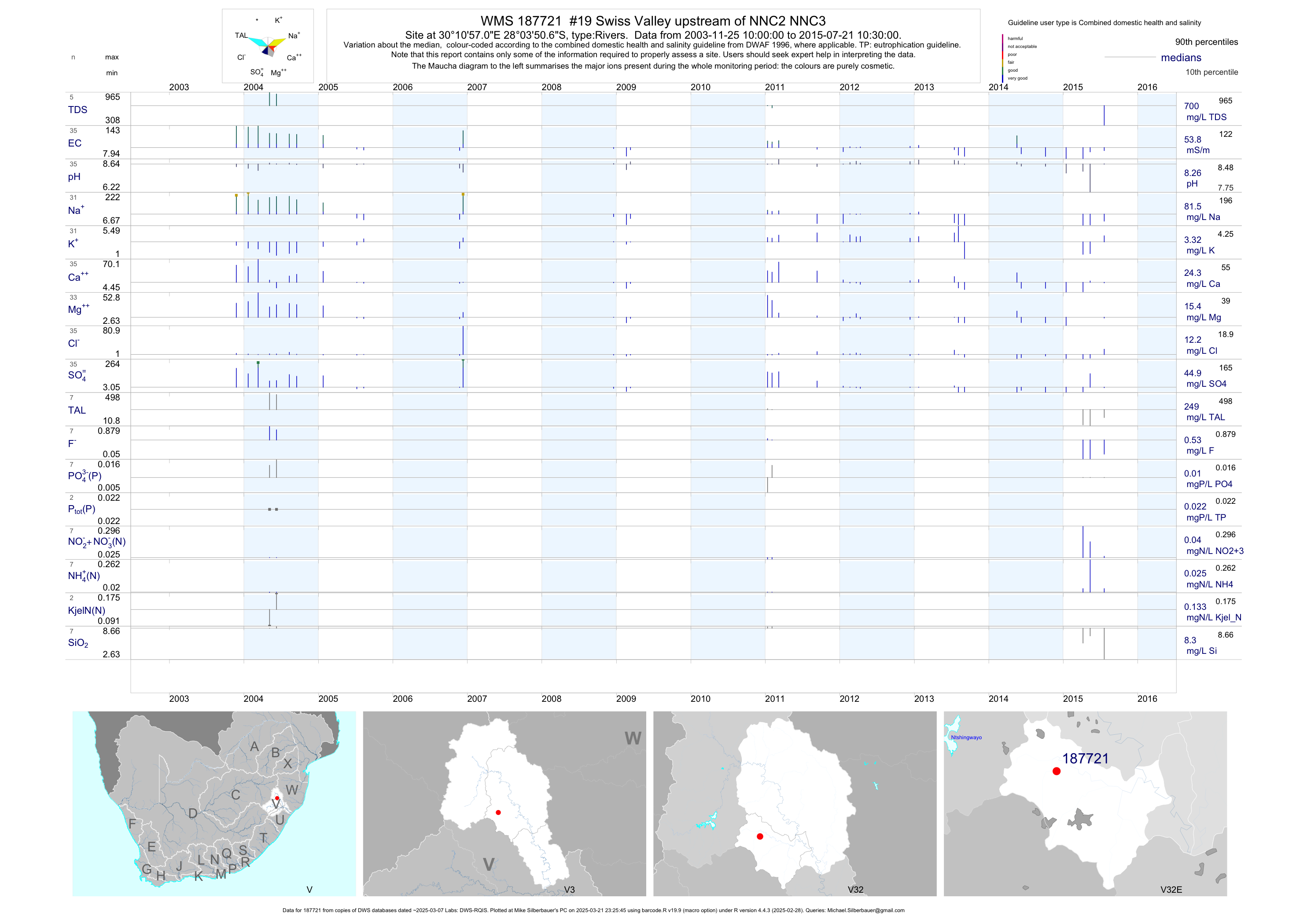
| V32 187721 | plot | data | #19 Swiss Valley upstream of NNC2 NNC3 | Rivers | 46 | 2003-11-25 | 2015-07-21 | 54 | 187721 | -28.06408 | 30.18250 |
| V32 187723 | plot | data | #15 Corby Rock Seepage from Corby Rock | Rivers | 37 | 2003-11-25 | 2014-06-05 | 127 | 187723 | -28.15428 | 30.38317 |
| V32 187724 | plot | data | #20 Swiss Valley Seepage from NNC2 | Rivers | 41 | 2003-11-25 | 2015-07-21 | 185 | 187724 | -28.06481 | 30.16808 |
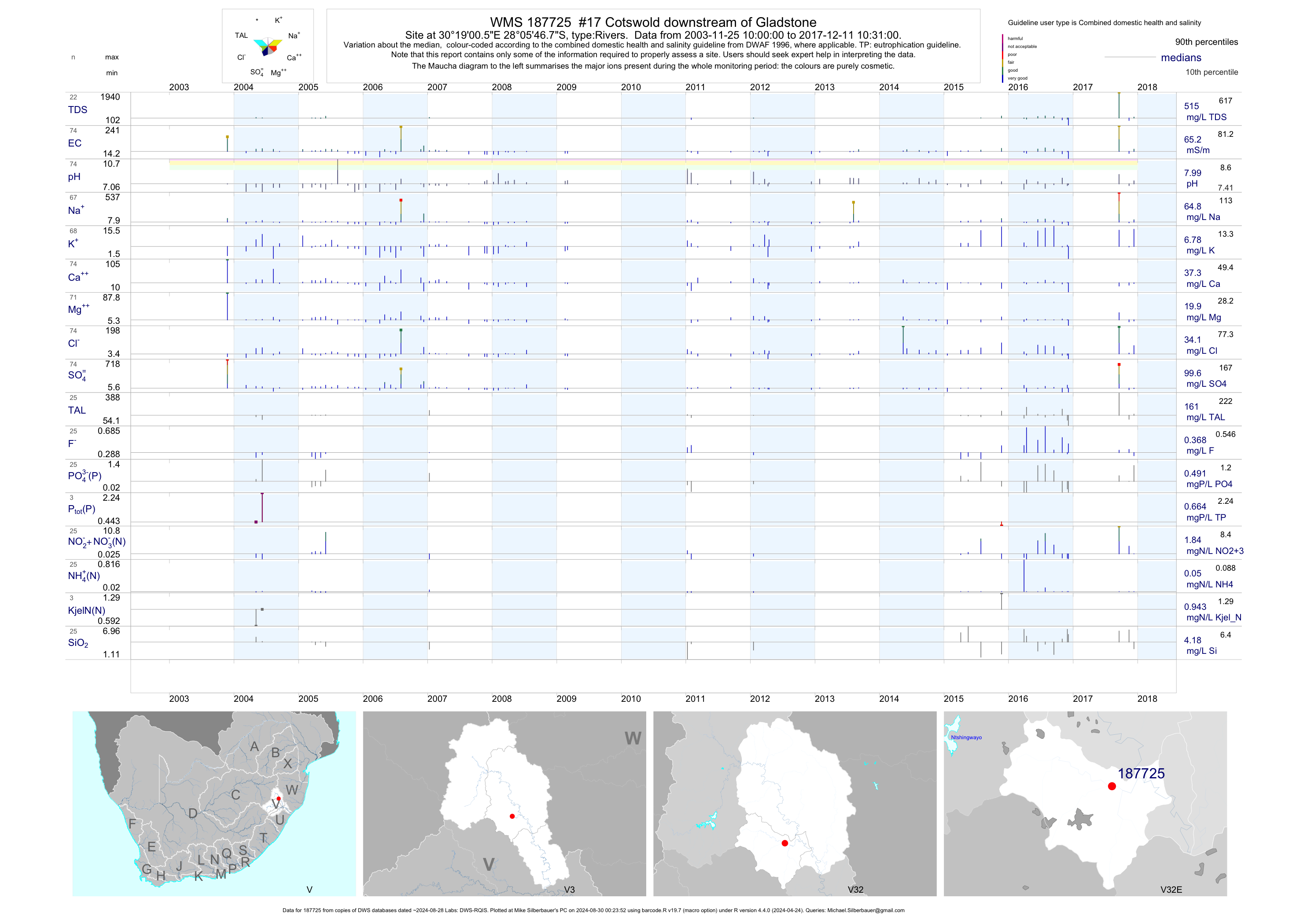
| V32 187725 | plot | data | #17 Cotswold downstream of Gladstone | Rivers | 84 | 2003-11-25 | 2017-12-11 | 64 | 187725 | -28.09631 | 30.31681 |
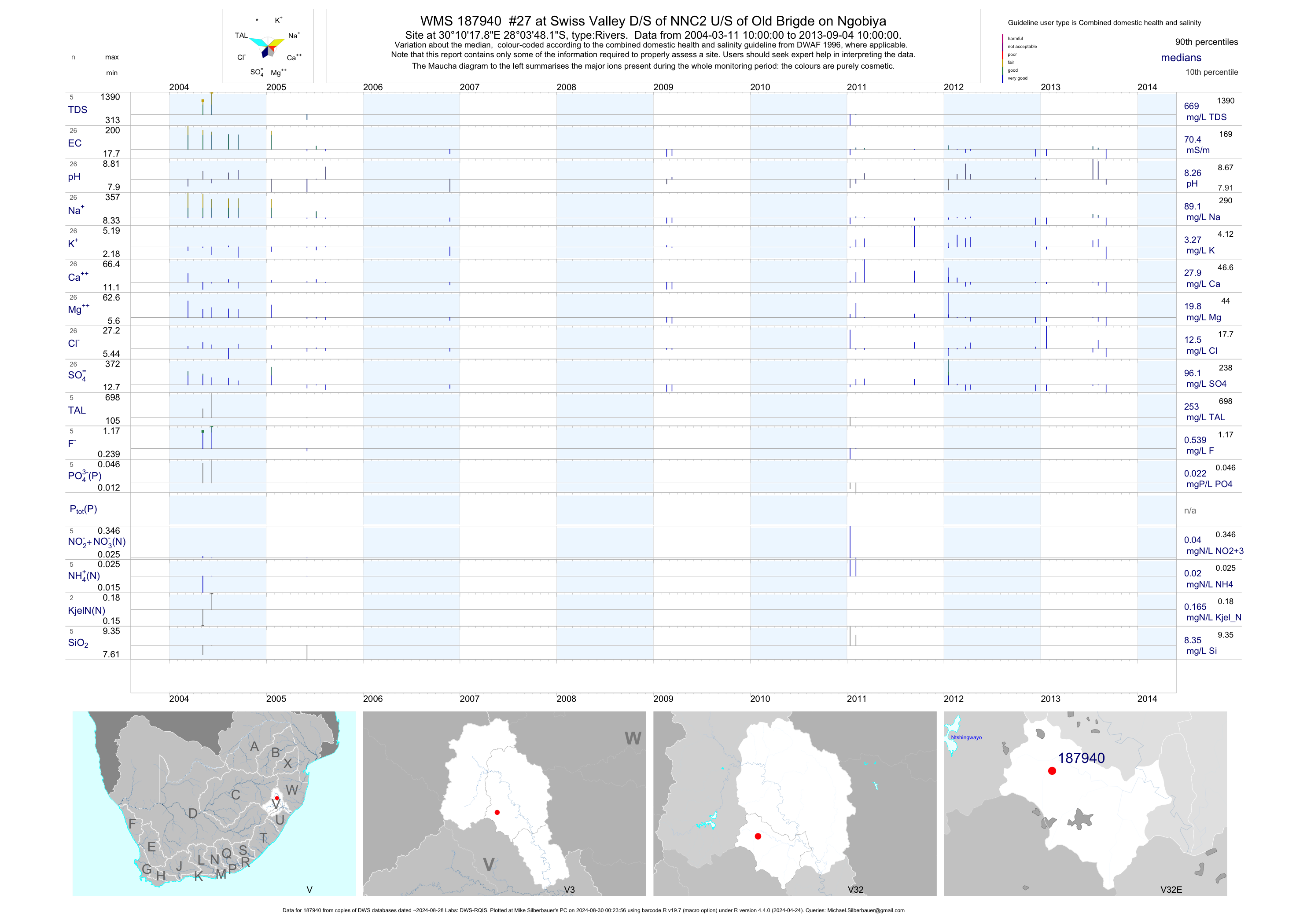
| V32 187940 | plot | data | #27 at Swiss Valley D/S of NNC2 U/S of Old Brigde on Ngobiya | Rivers | 33 | 2004-03-11 | 2013-09-04 | 70 | 187940 | -28.06339 | 30.17164 |
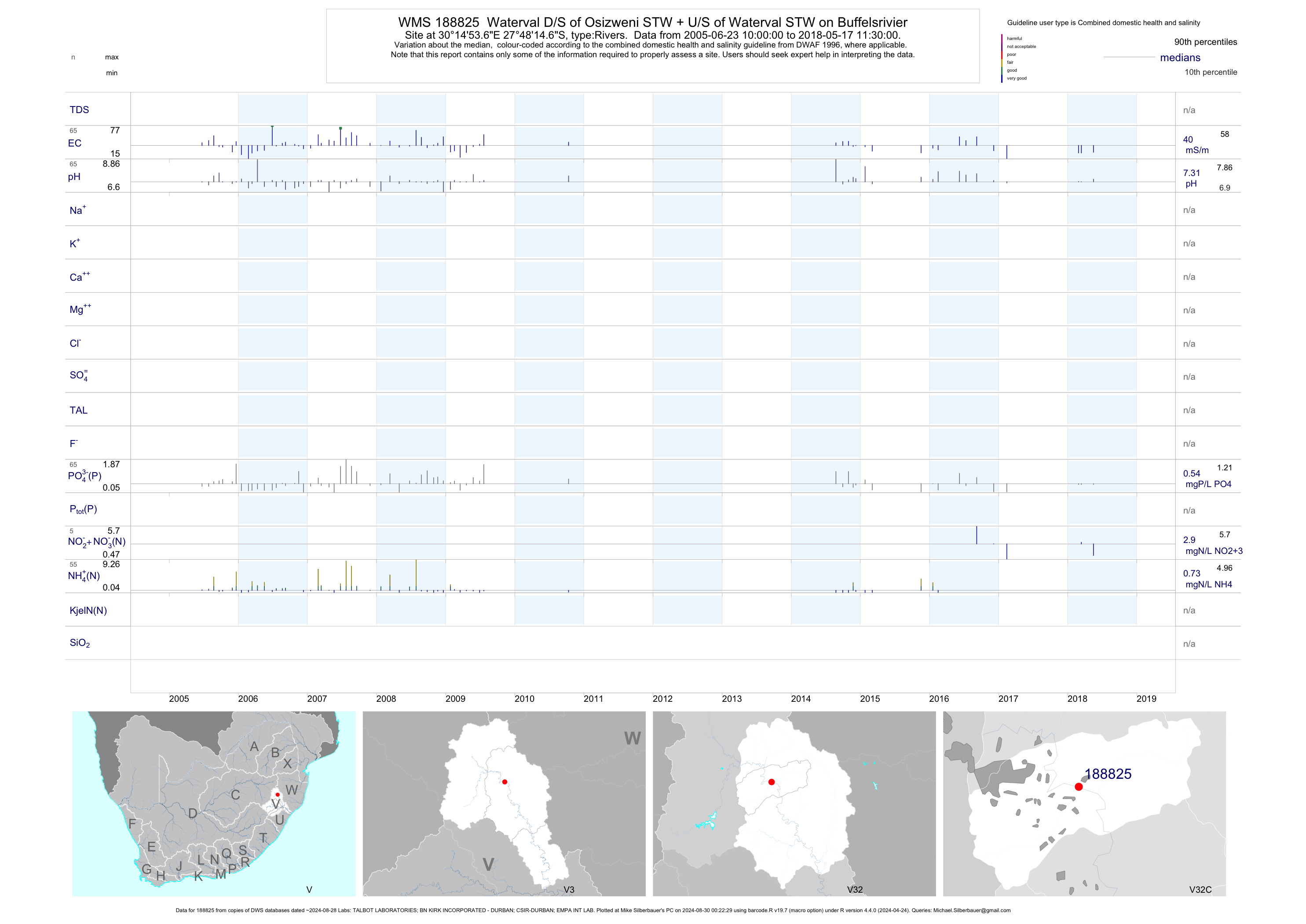
| V32 188825 | plot | data | Waterval D/S of Osizweni STW + U/S of Waterval STW on Buffelsrivier | Rivers | 91 | 2005-06-23 | 2017-03-13 | 42 | 188825 | -27.80408 | 30.24822 |
| V32 188835 | plot | data | Witteklip upstream of Osizweni STW Final Effluent Discharge on Buffels Srivier | Rivers | 92 | 2005-06-23 | 2017-03-13 | 39 | 188835 | -27.74003 | 30.20336 |
| V32 188842 | plot | data | Waterval downstream of Waterval STW on Buffelsrivier | Rivers | 97 | 2005-06-23 | 2017-03-13 | 42 | 188842 | -27.80717 | 30.25939 |
| V31 188866 | plot | data | Kilbarchan D/S of Horn and Ngagane Confluence U/S of Kilbarchan on Inga Agane | Rivers | 62 | 2006-03-22 | 2017-01-23 | 44 | 188866 | -27.88428 | 29.97528 |
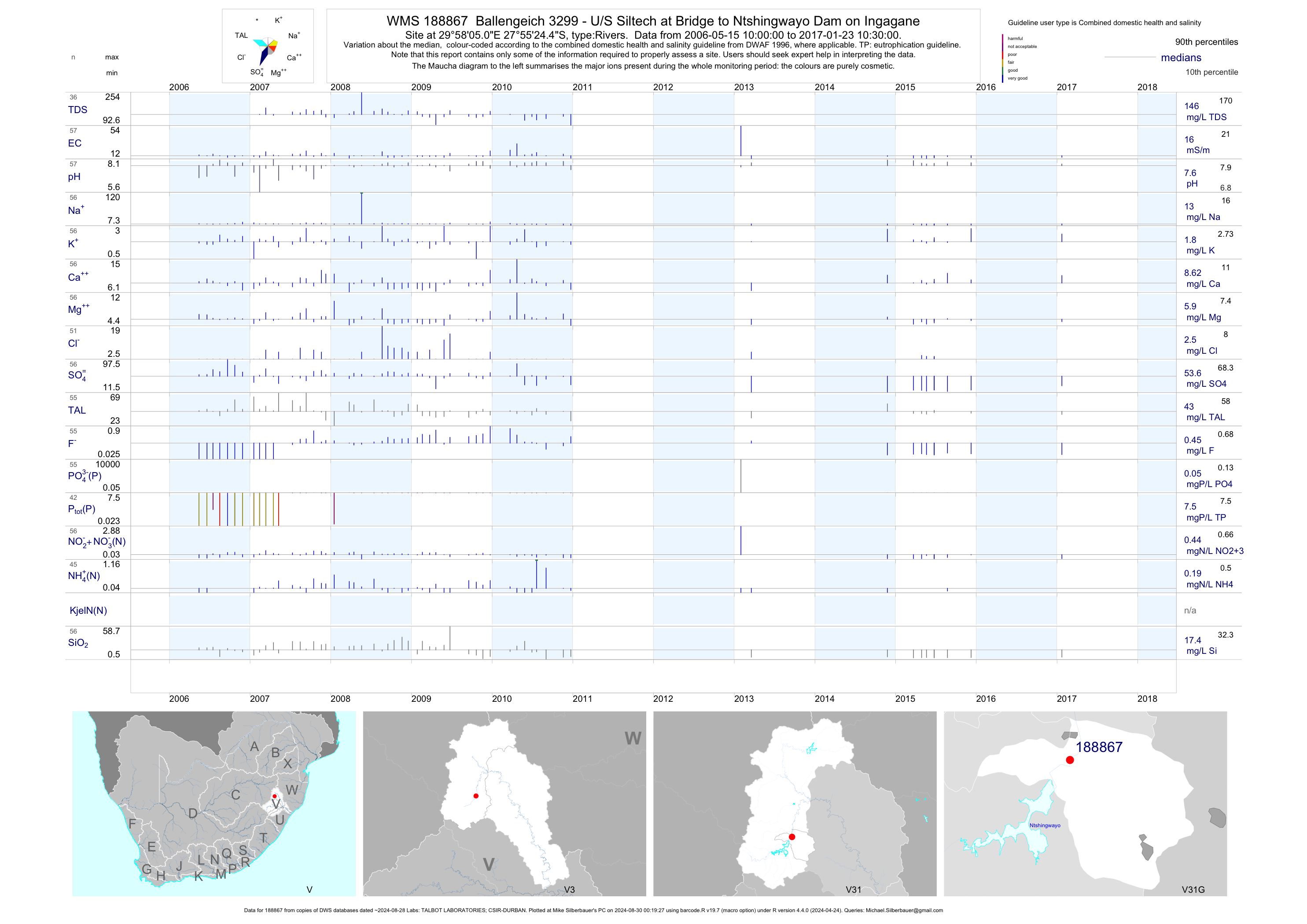
| V31 188867 | plot | data | Ballengeich 3299 - U/S Siltech at Bridge to Ntshingwayo Dam on Ingagane | Rivers | 61 | 2006-05-15 | 2017-01-23 | 16 | 188867 | -27.92347 | 29.96808 |
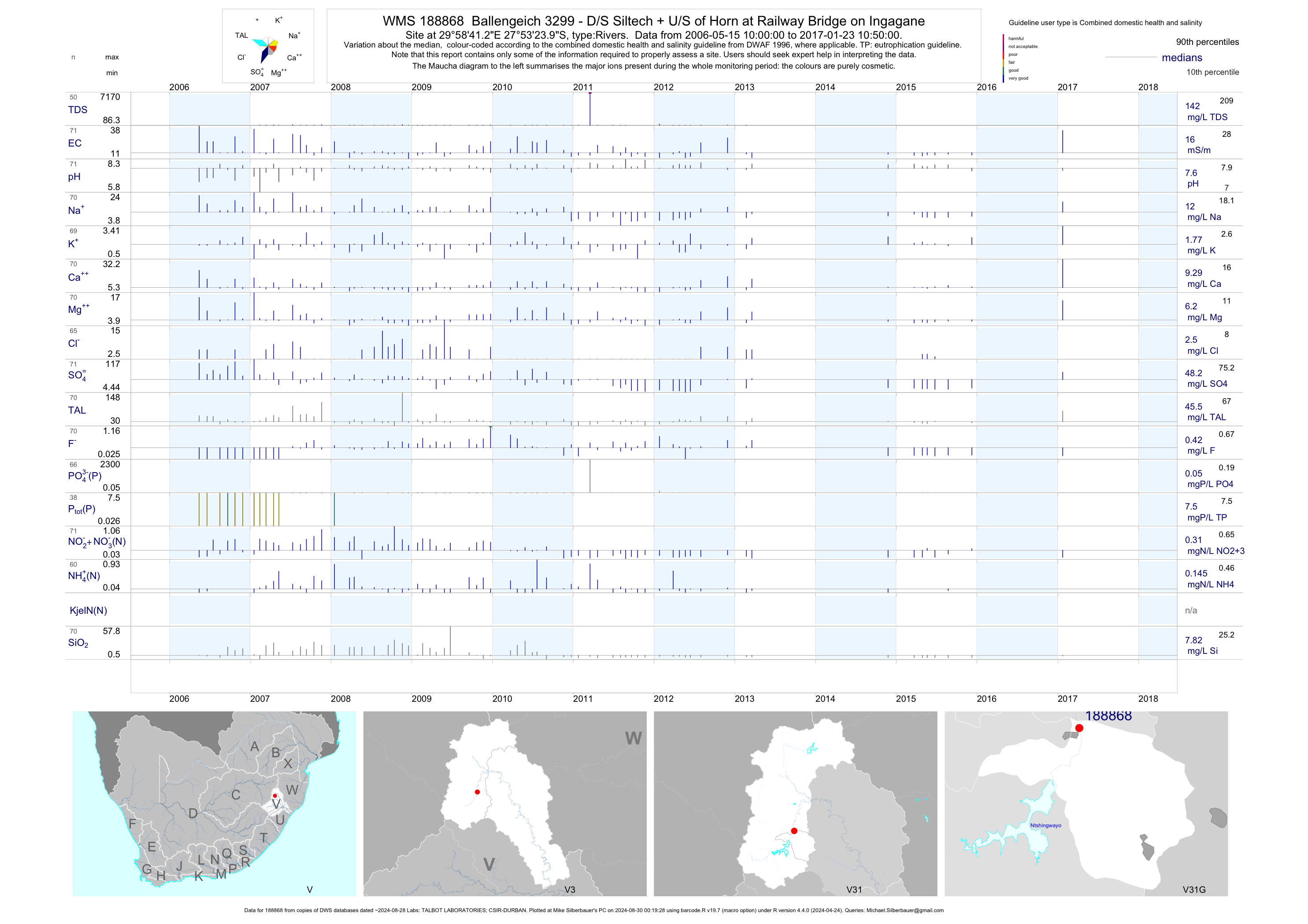
| V31 188868 | plot | data | Ballengeich 3299 - D/S Siltech + U/S of Horn at Railway Bridge on Ingagane | Rivers | 75 | 2006-05-15 | 2017-01-23 | 16 | 188868 | -27.89000 | 29.97813 |
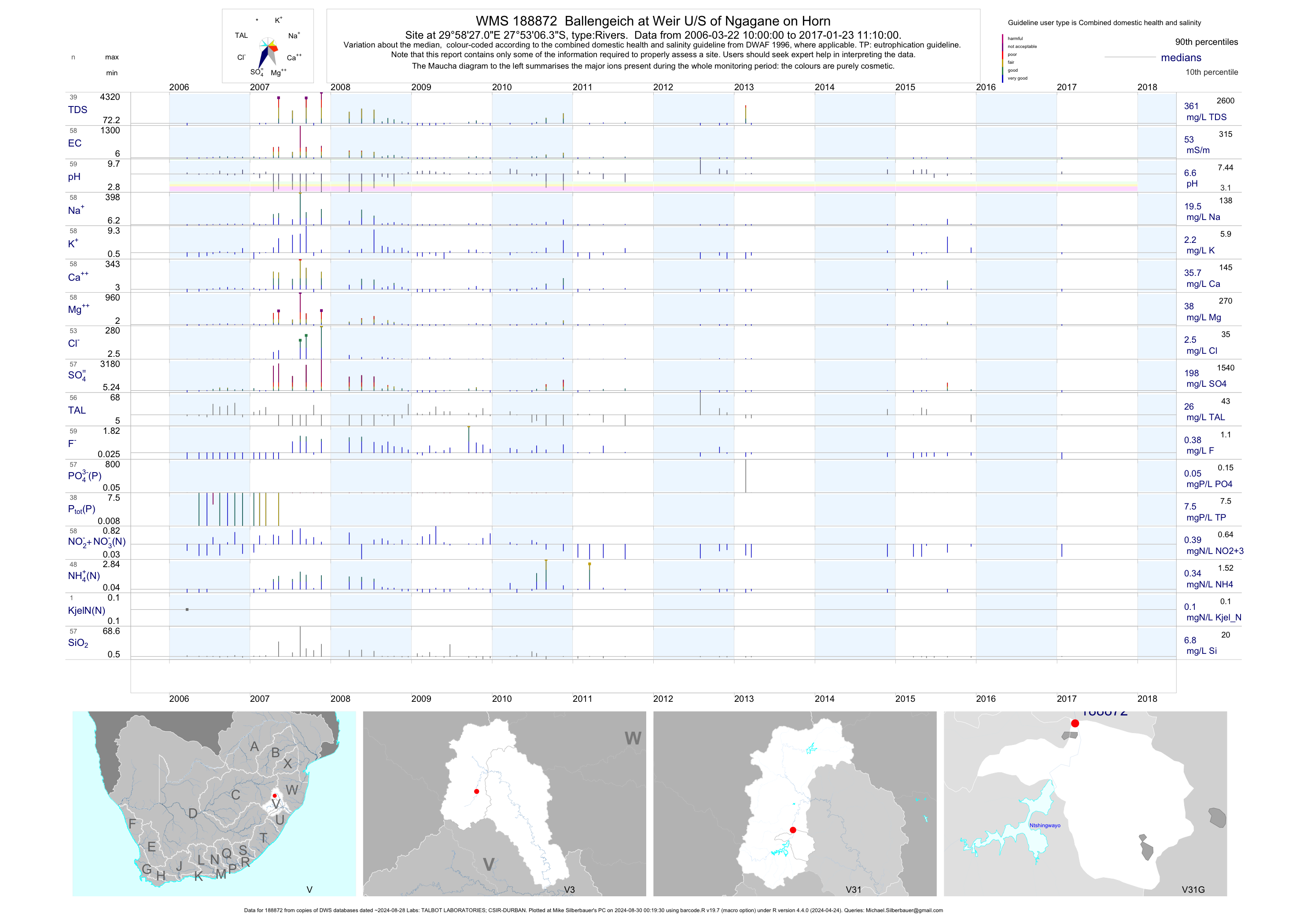
| V31 188872 | plot | data | Ballengeich at Weir U/S of Ngagane on Horn | Rivers | 63 | 2006-03-22 | 2017-01-23 | 60 | 188872 | -27.88508 | 29.97417 |
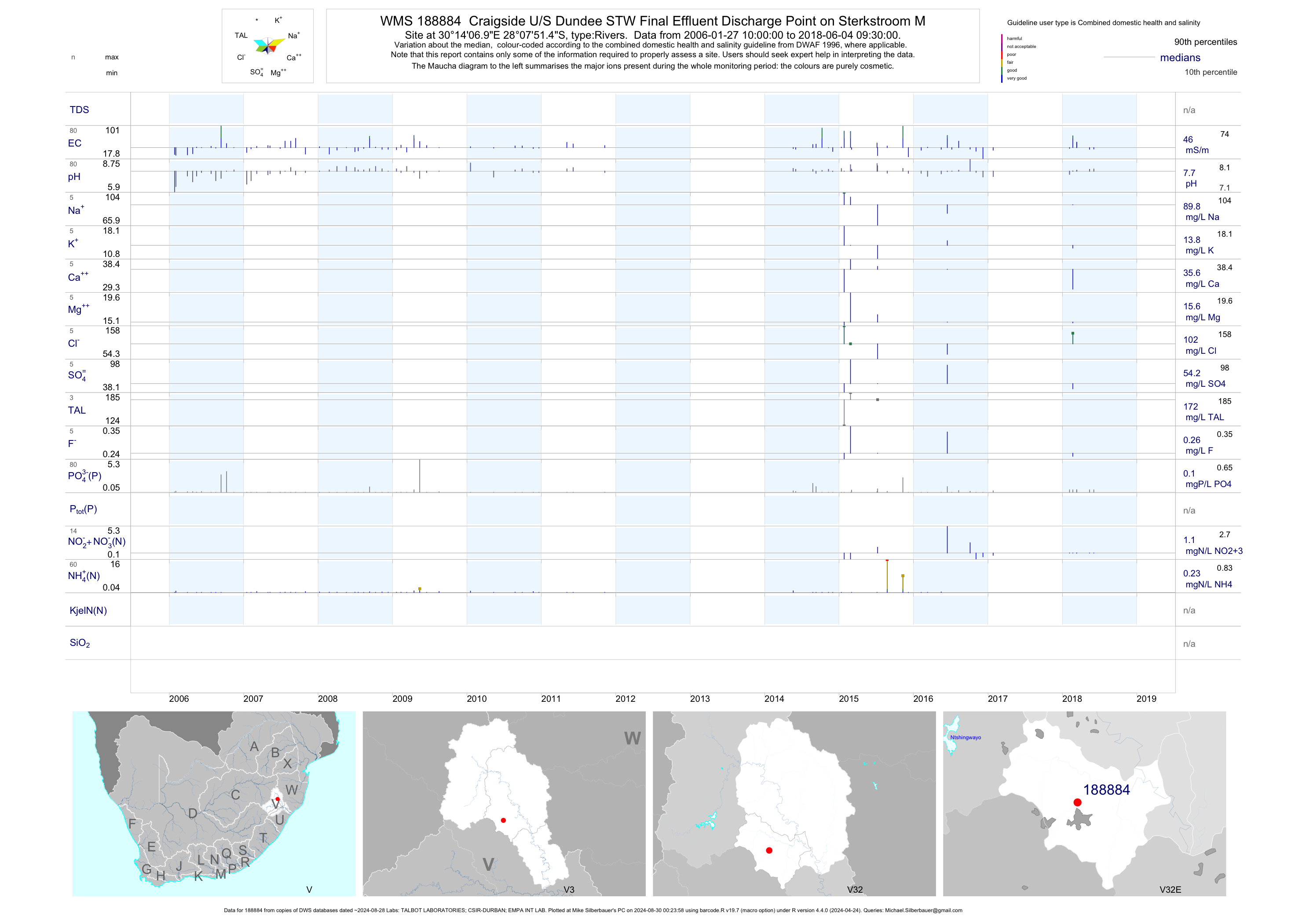
| V32 188884 | plot | data | Craigside U/S Dundee STW Final Effluent Discharge Point on Sterkstroom M | Rivers | 95 | 2006-01-27 | 2017-02-06 | 46 | 188884 | -28.13094 | 30.23528 |
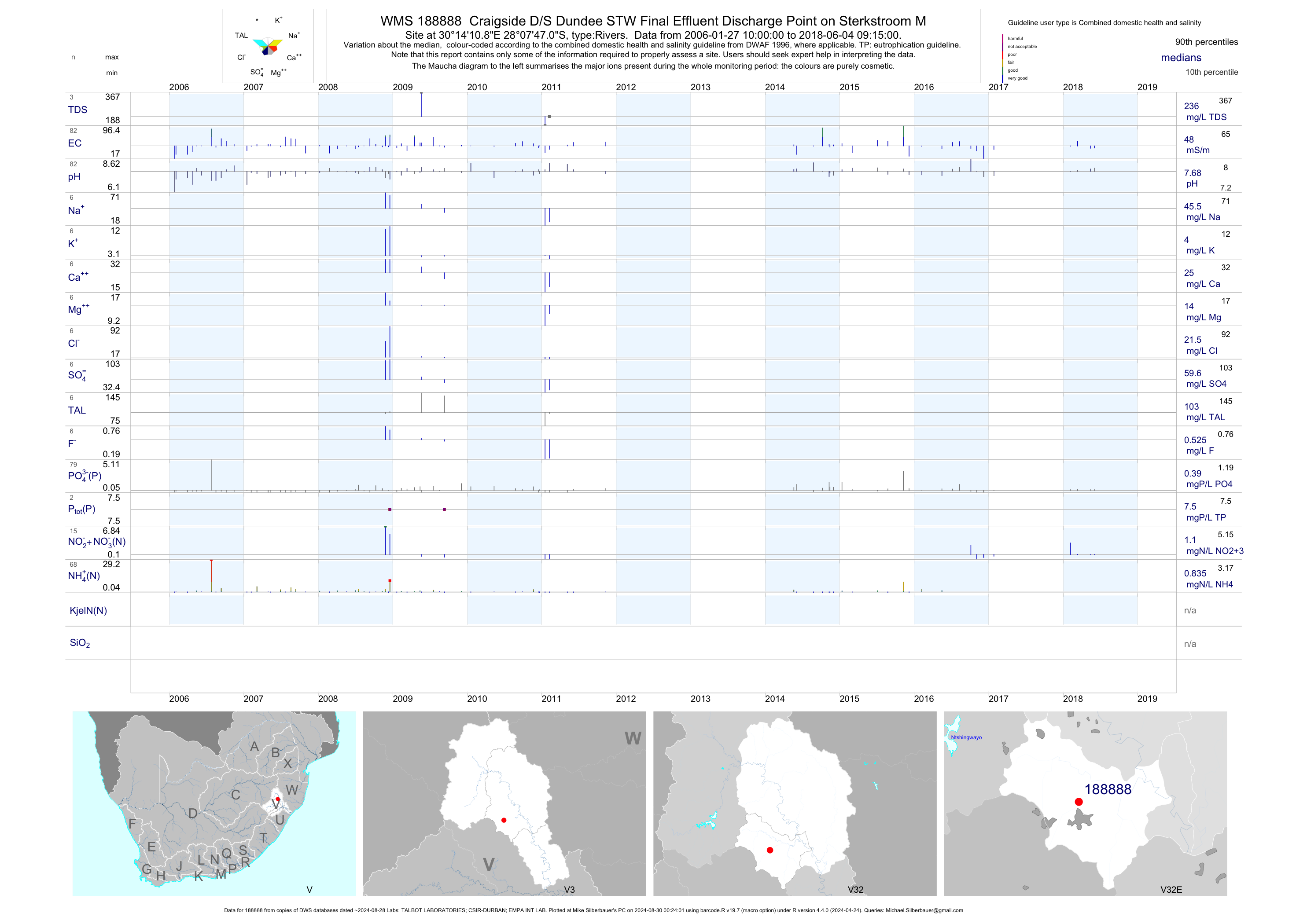
| V32 188888 | plot | data | Craigside D/S Dundee STW Final Effluent Discharge Point on Sterkstroom M | Rivers | 103 | 2006-01-27 | 2017-02-06 | 48 | 188888 | -28.12972 | 30.23636 |
| V31 188917 | plot | data | Newcastle Township - at Weir on Ngagane | Rivers | 57 | 2006-04-11 | 2010-12-23 | 45 | 188917 | -27.76983 | 30.01706 |
| V31 188918 | plot | data | Roy Point at Uthukela Abstraction Point on Ingagane | Rivers | 56 | 2006-04-11 | 2015-10-27 | 38 | 188918 | -27.79861 | 29.98839 |
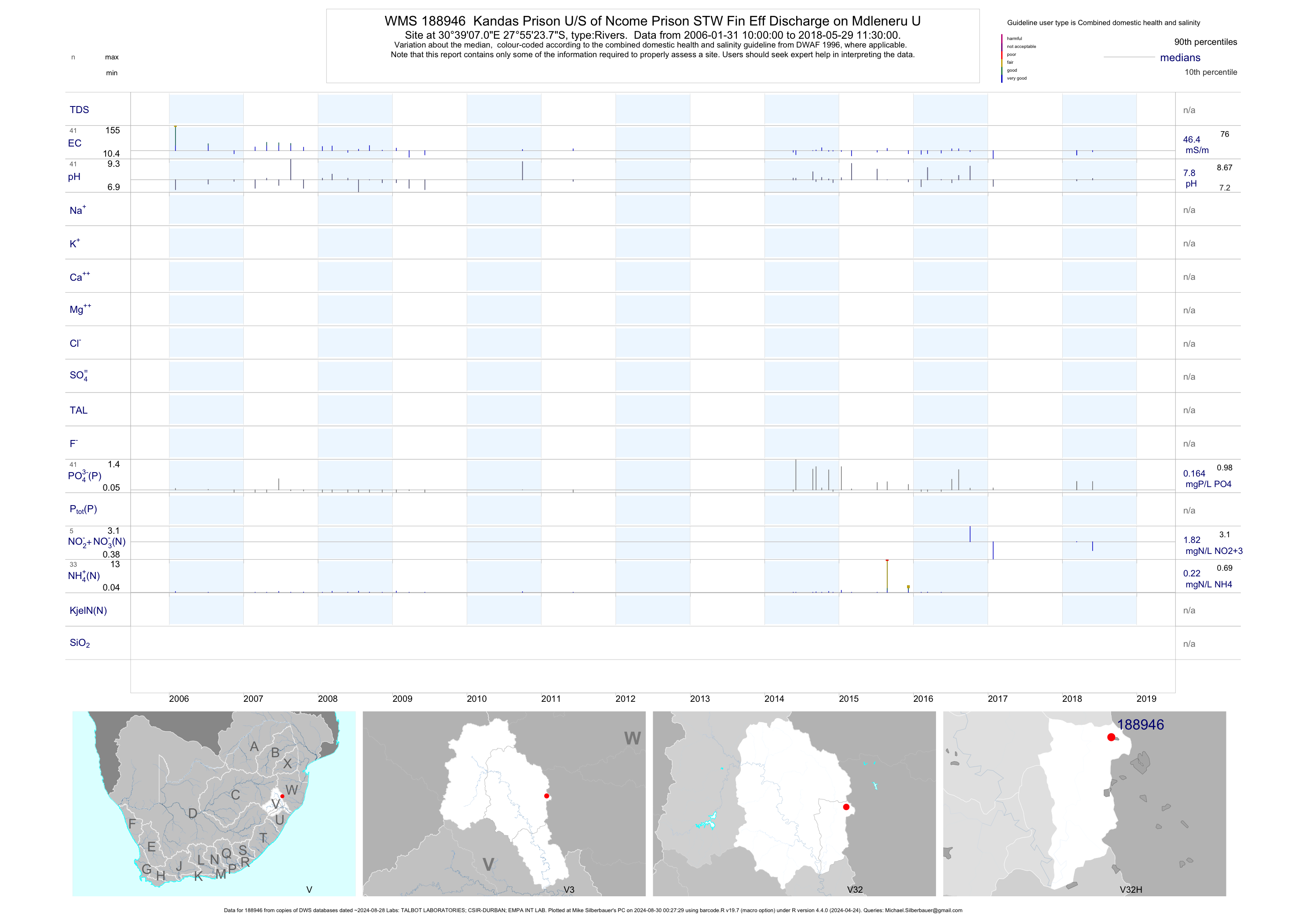
| V32 188946 | plot | data | Kandas Prison U/S of Ncome Prison STW Fin Eff Discharge on Mdleneru U | Rivers | 52 | 2006-01-31 | 2017-02-06 | 50 | 188946 | -27.92325 | 30.65194 |
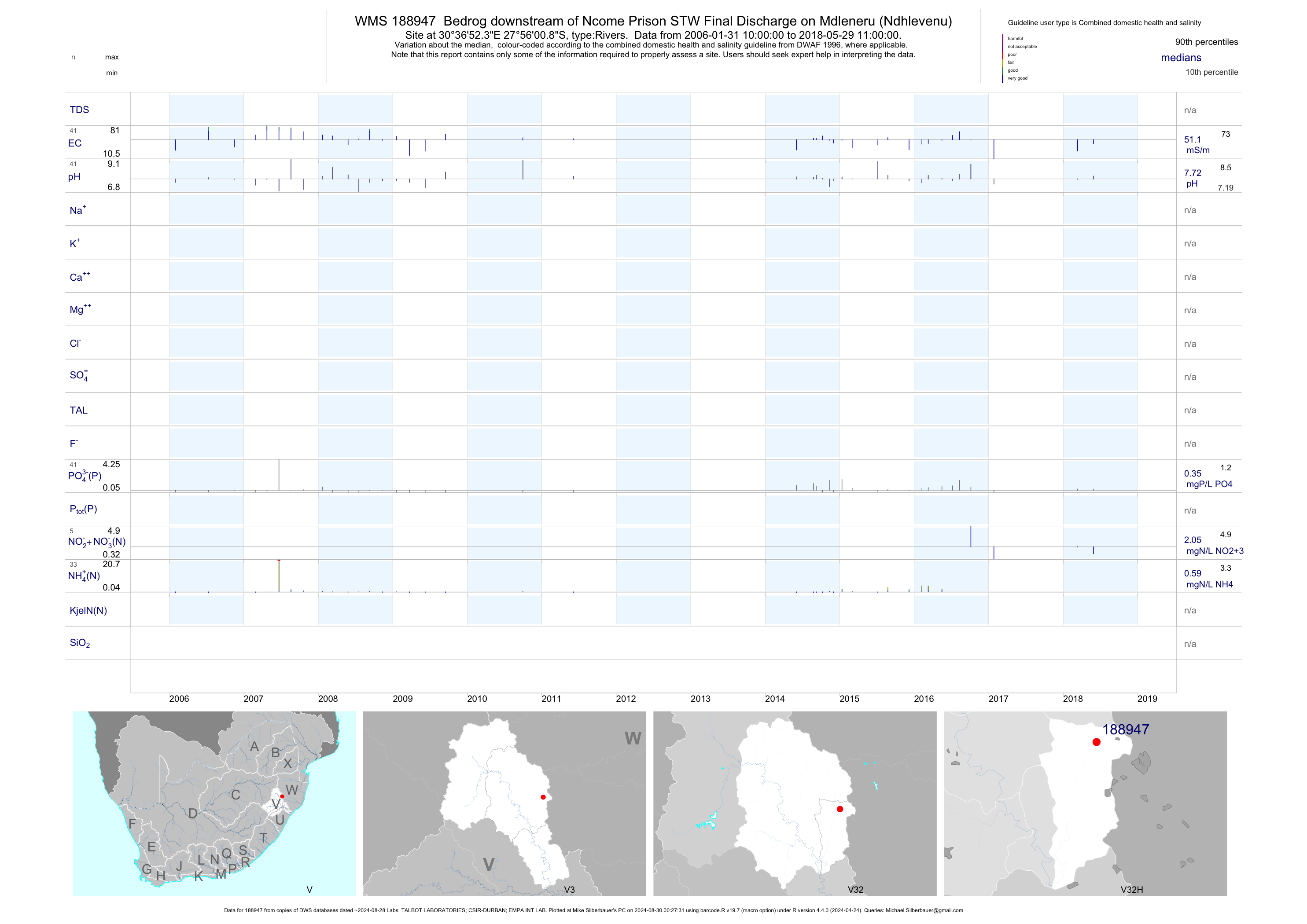
| V32 188947 | plot | data | Bedrog downstream of Ncome Prison STW Final Discharge on Mdleneru (Ndhlevenu) | Rivers | 53 | 2006-01-31 | 2017-02-06 | 53 | 188947 | -27.93356 | 30.61453 |
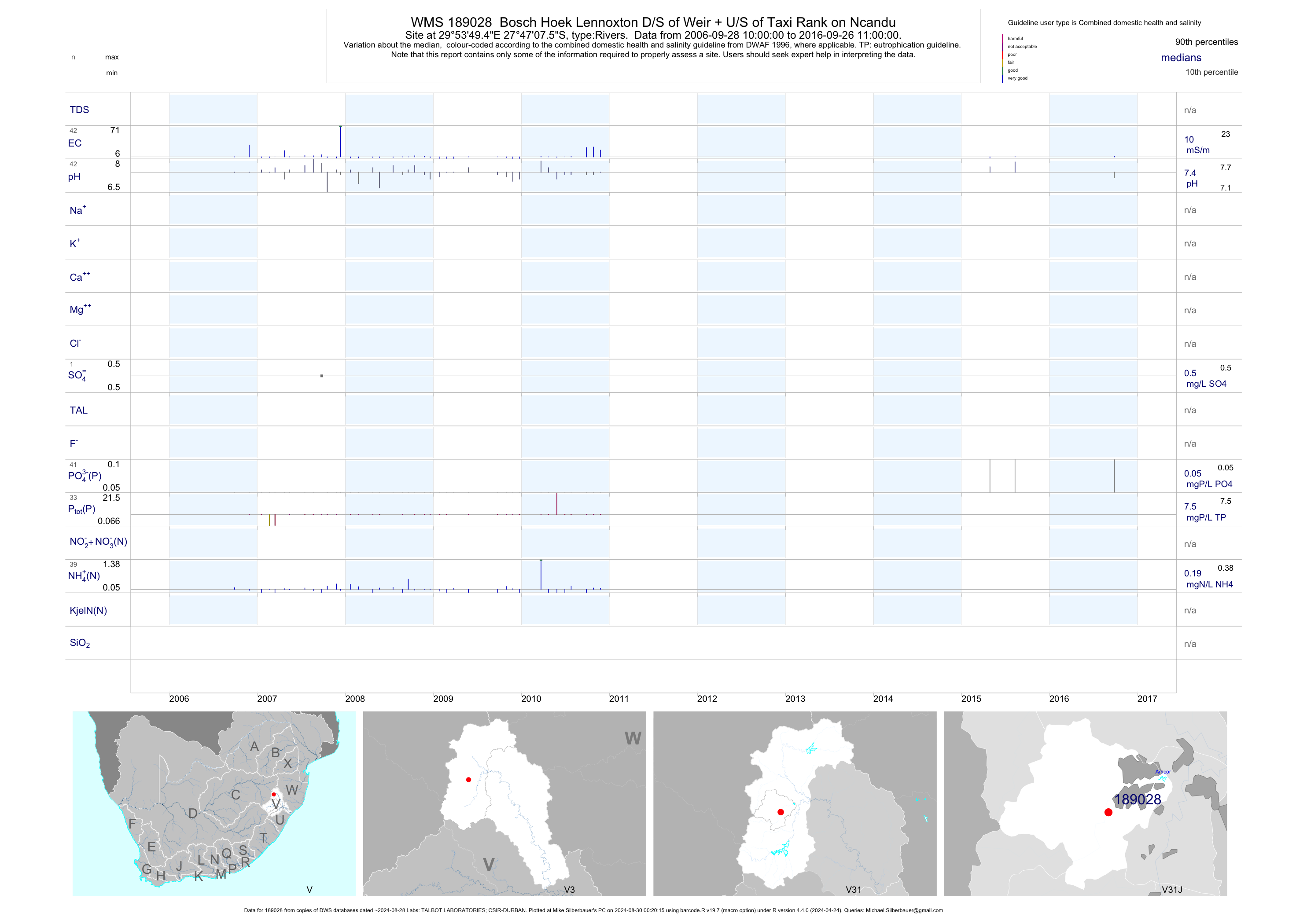
| V31 189028 | plot | data | Bosch Hoek Lennoxton D/S of Weir + U/S of Taxi Rank on Ncandu | Rivers | 42 | 2006-09-28 | 2016-09-26 | 10 | 189028 | -27.78542 | 29.89708 |
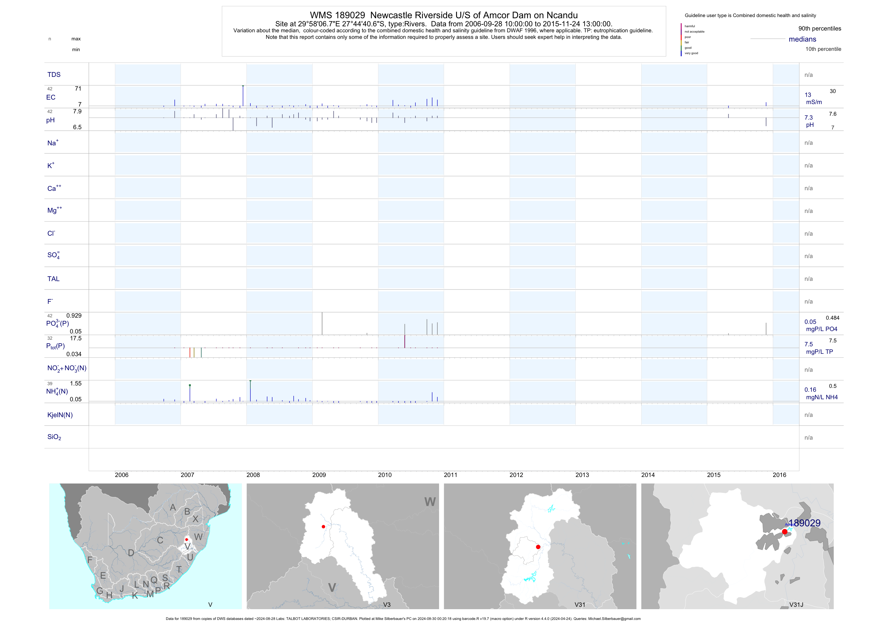
| V31 189029 | plot | data | Newcastle Riverside U/S of Amcor Dam on Ncandu | Rivers | 42 | 2006-09-28 | 2015-11-24 | 13 | 189029 | -27.74464 | 29.96856 |
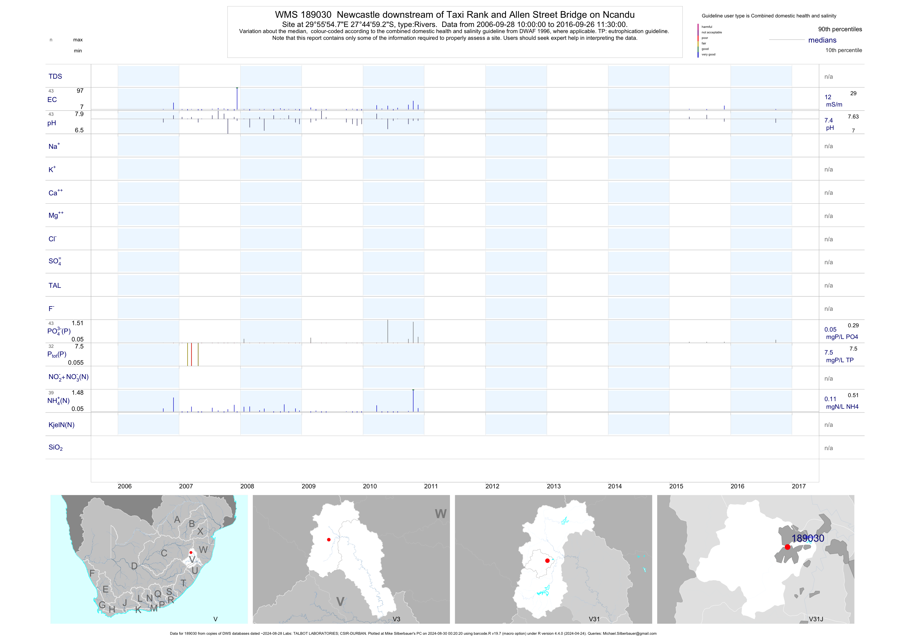
| V31 189030 | plot | data | Newcastle downstream of Taxi Rank and Allen Street Bridge on Ncandu | Rivers | 43 | 2006-09-28 | 2016-09-26 | 12 | 189030 | -27.74981 | 29.93186 |
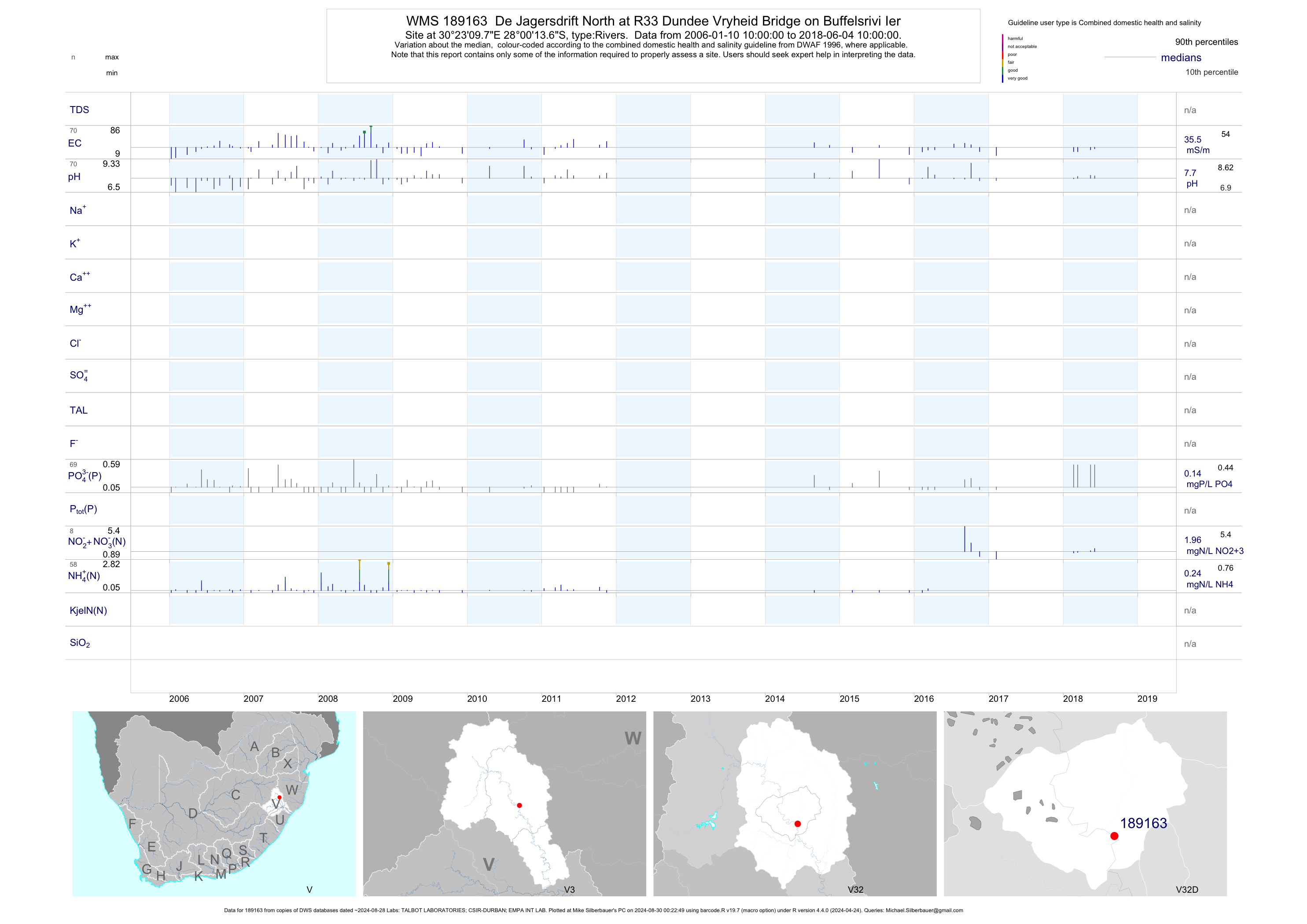
| V32 189163 | plot | data | De Jagersdrift North at R33 Dundee Vryheid Bridge on Buffelsrivi Ier | Rivers | 81 | 2006-01-10 | 2017-03-07 | 37 | 189163 | -28.00378 | 30.38606 |
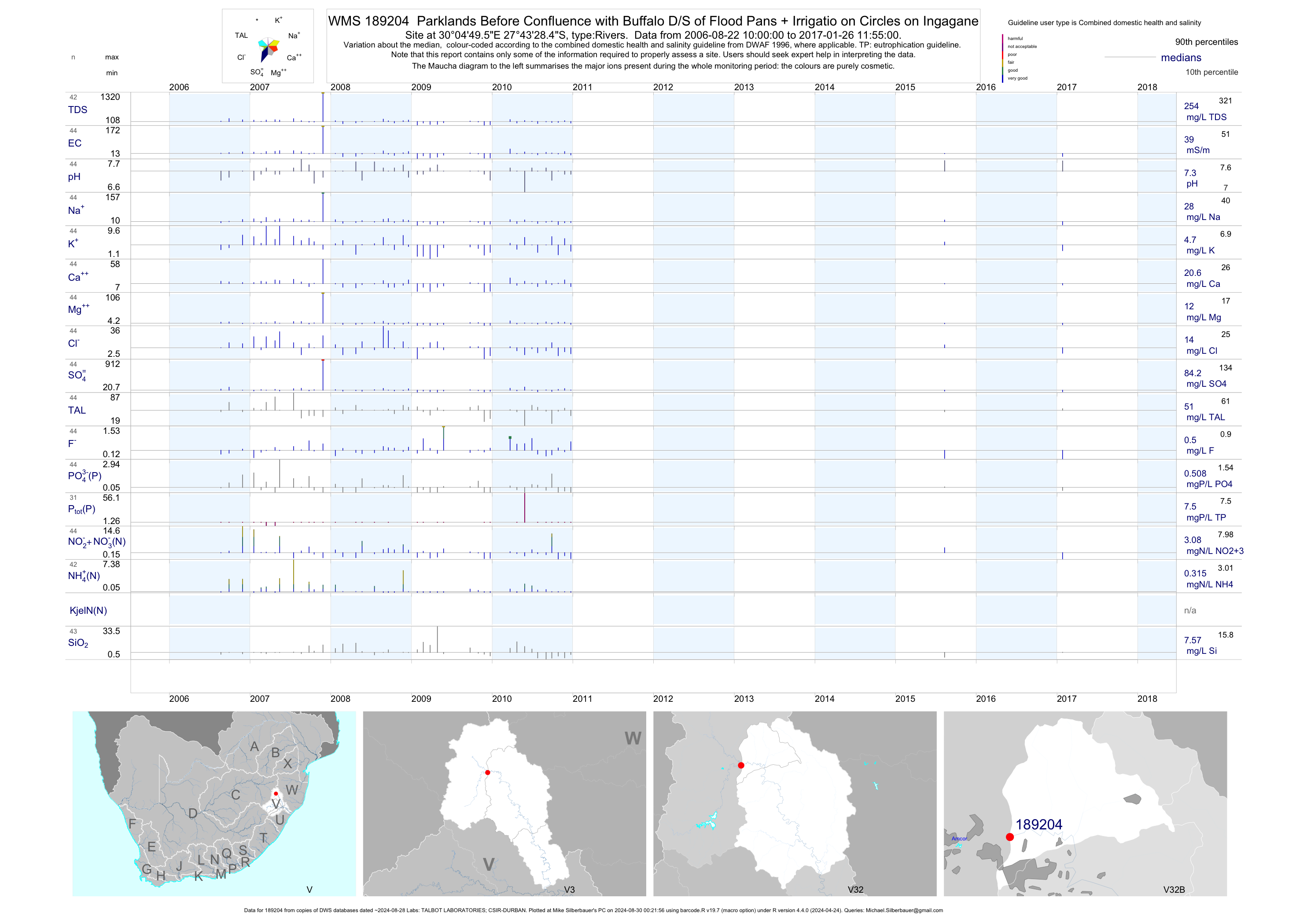
| V32 189204 | plot | data | Parklands Before Confluence with Buffalo D/S of Flood Pans + Irrigatio on Circles on Ingagane | Rivers | 43 | 2006-08-22 | 2017-01-26 | 39 | 189204 | -27.72456 | 30.08044 |
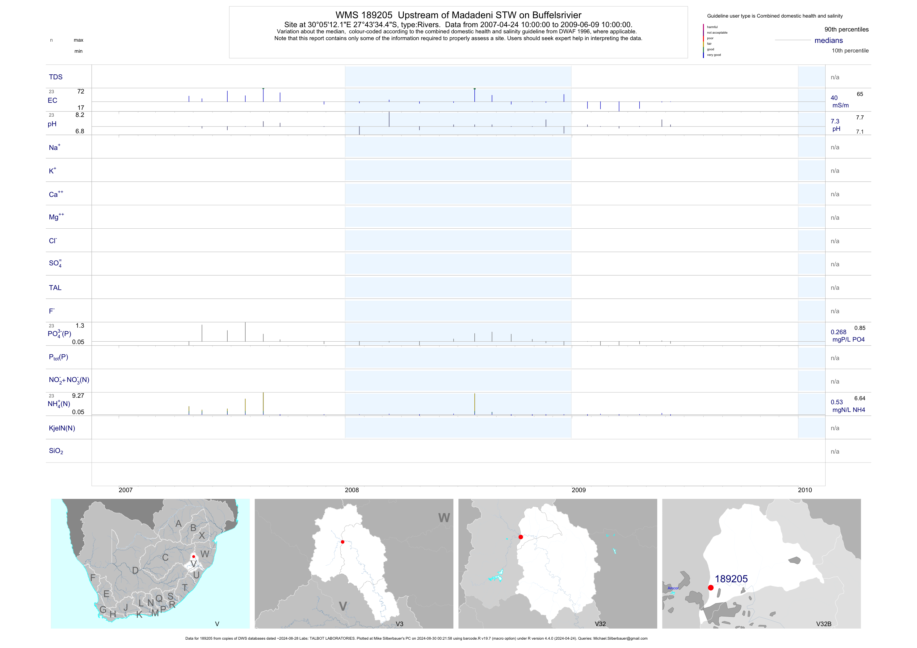
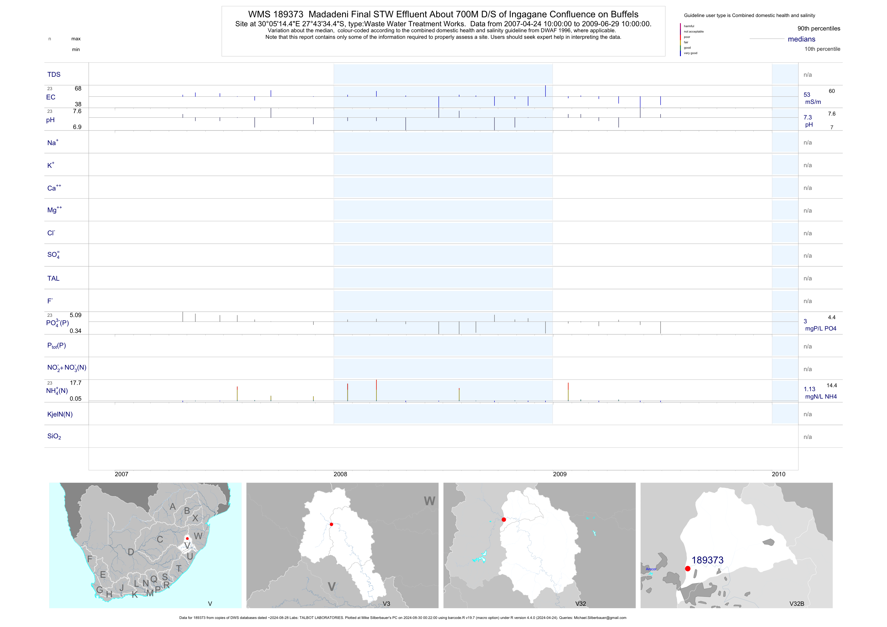
| V32 189205 | plot | data | Upstream of Madadeni STW on Buffelsrivier | Rivers | 23 | 2007-04-24 | 2009-06-09 | 40 | 189205 | -27.72622 | 30.08669 |
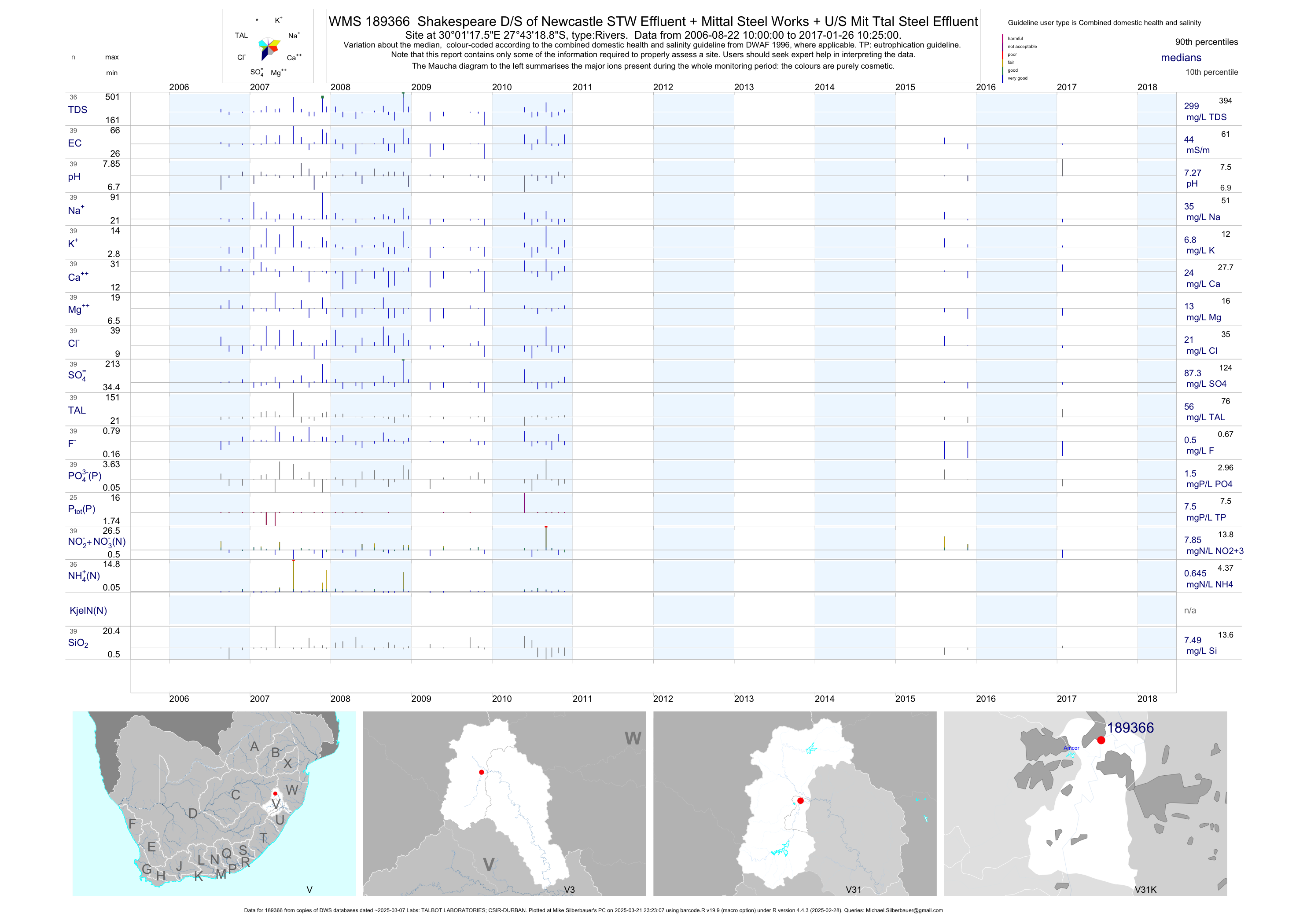
| V31 189366 | plot | data | Shakespeare D/S of Newcastle STW Effluent + Mittal Steel Works + U/S Mit Ttal Steel Effluent | Rivers | 37 | 2006-08-22 | 2017-01-26 | 44 | 189366 | -27.72192 | 30.02153 |
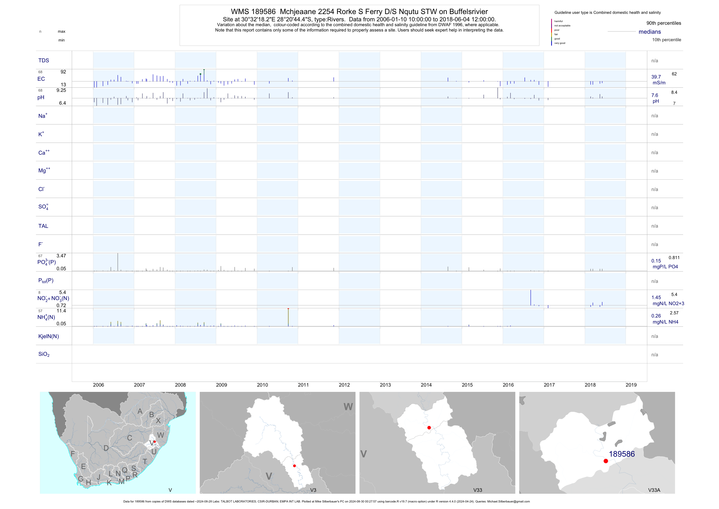
| V33 189586 | plot | data | Mchjeaane 2254 Rorke S Ferry D/S Nqutu STW on Buffelsrivier | Rivers | 78 | 2006-01-10 | 2017-03-07 | 41 | 189586 | -28.34567 | 30.53842 |
| V31 189701 | plot | data | White House 14178 at Main Road 186 Bridge upstream of Ingogo on Har Rterivier | Rivers | 49 | 2007-06-11 | 2017-02-08 | 40 | 189701 | -27.58139 | 29.87333 |
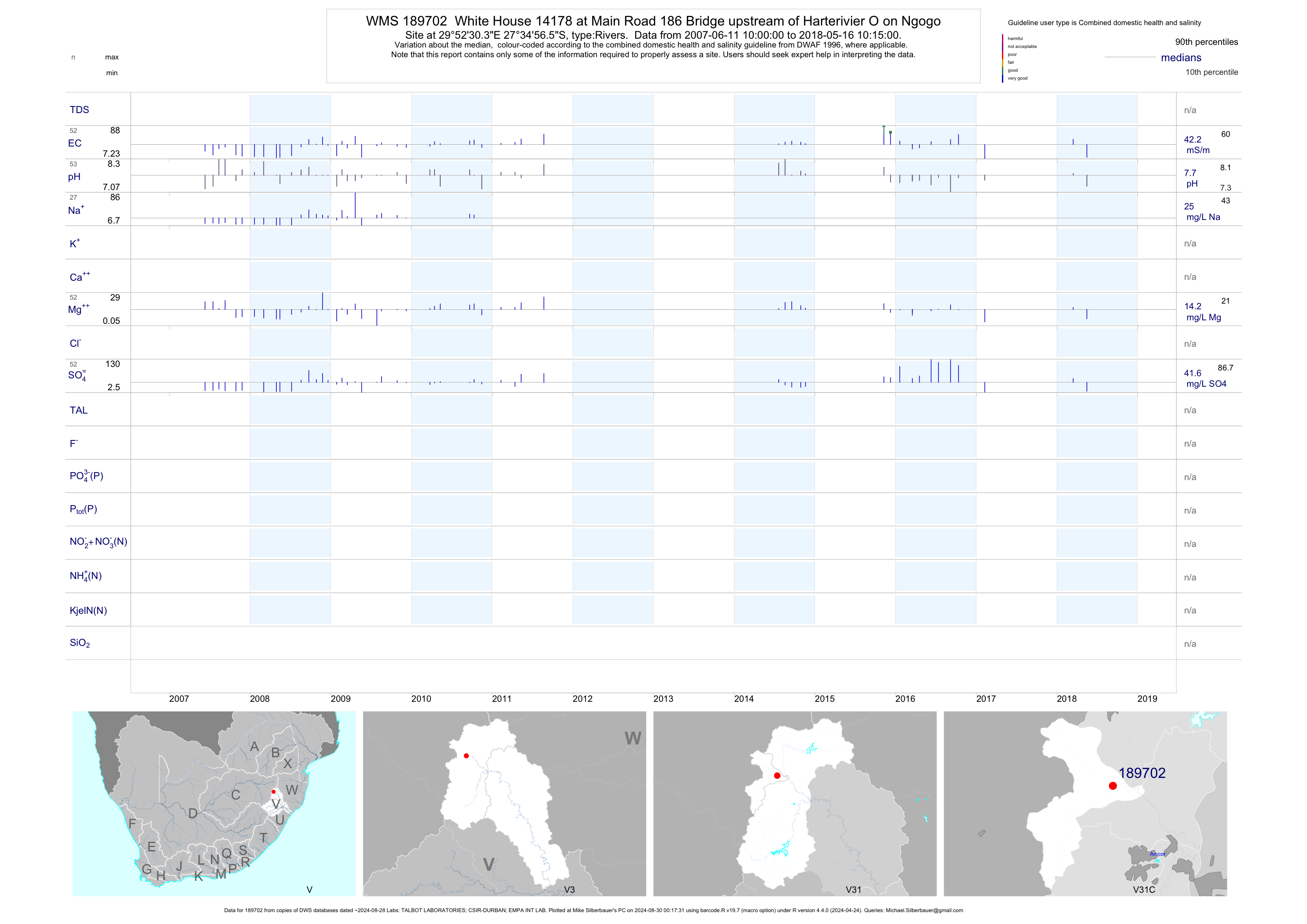
| V31 189702 | plot | data | White House 14178 at Main Road 186 Bridge upstream of Harterivier O on Ngogo | Rivers | 47 | 2007-06-11 | 2017-02-08 | 43 | 189702 | -27.58236 | 29.87511 |
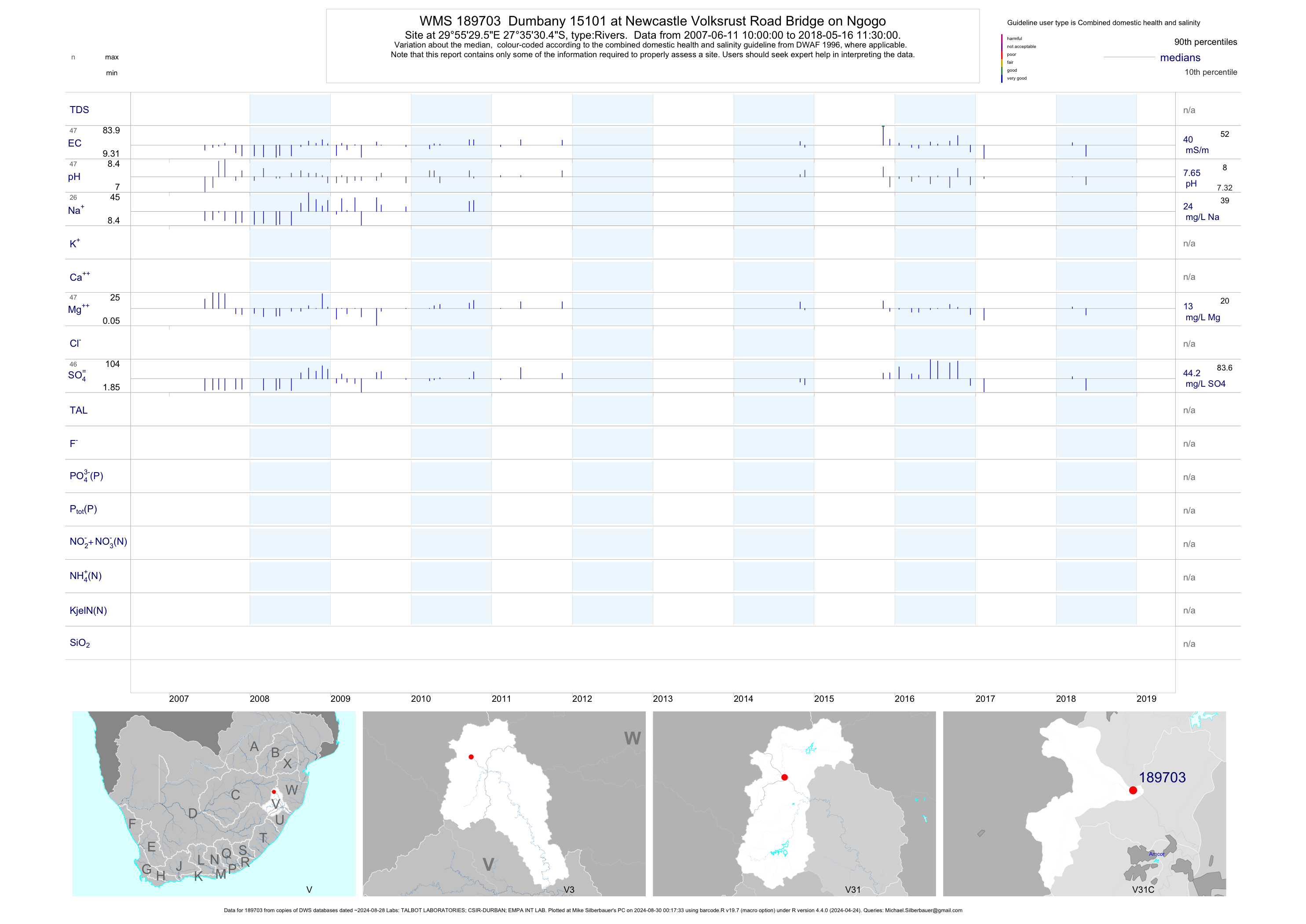
| V31 189703 | plot | data | Dumbany 15101 at Newcastle Volksrust Road Bridge on Ngogo | Rivers | 43 | 2007-06-11 | 2017-02-08 | 40 | 189703 | -27.59178 | 29.92489 |
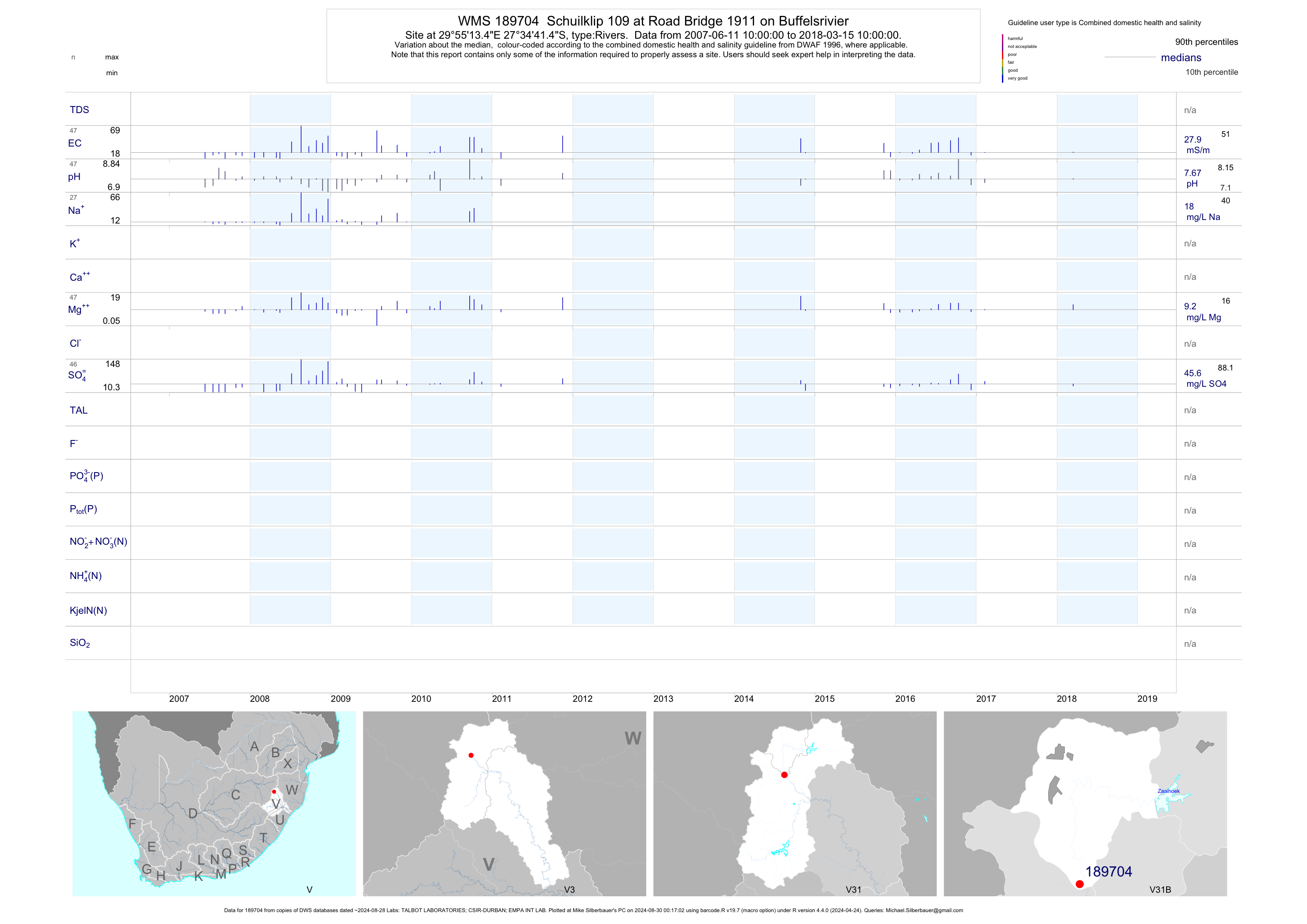
| V31 189704 | plot | data | Schuilklip 109 at Road Bridge 1911 on Buffelsrivier | Rivers | 44 | 2007-06-11 | 2017-02-08 | 28 | 189704 | -27.57819 | 29.92039 |
| V32 192150 | plot | data | Sterkstroom at U/S Avoca | Rivers | 8 | 2008-11-25 | 2017-01-30 | 42 | 192150 | -28.14472 | 30.22833 |
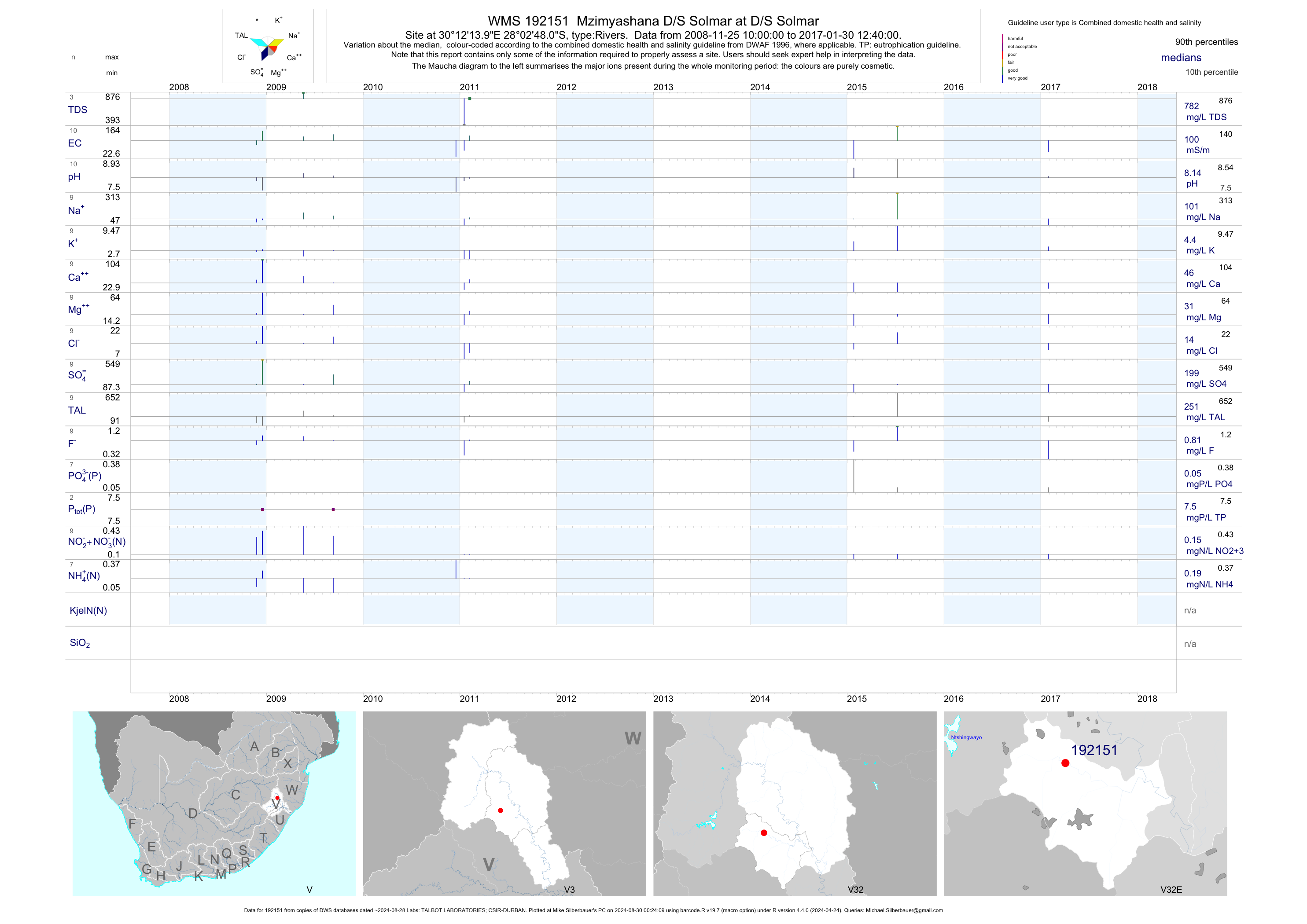
| V32 192151 | plot | data | Mzimyashana D/S Solmar at D/S Solmar | Rivers | 8 | 2008-11-25 | 2017-01-30 | 100 | 192151 | -28.04667 | 30.20389 |
| V32 192153 | plot | data | Sandspruit on Nqutu Road Bridge | Rivers | 9 | 2008-11-04 | 2017-01-30 | 42 | 192153 | -28.13972 | 30.33167 |
| V32 192154 | plot | data | Sandspruit/Sterkspruit on Vryheid Road Bridge | Rivers | 8 | 2008-11-04 | 2017-01-30 | 61 | 192154 | -28.09631 | 30.31681 |
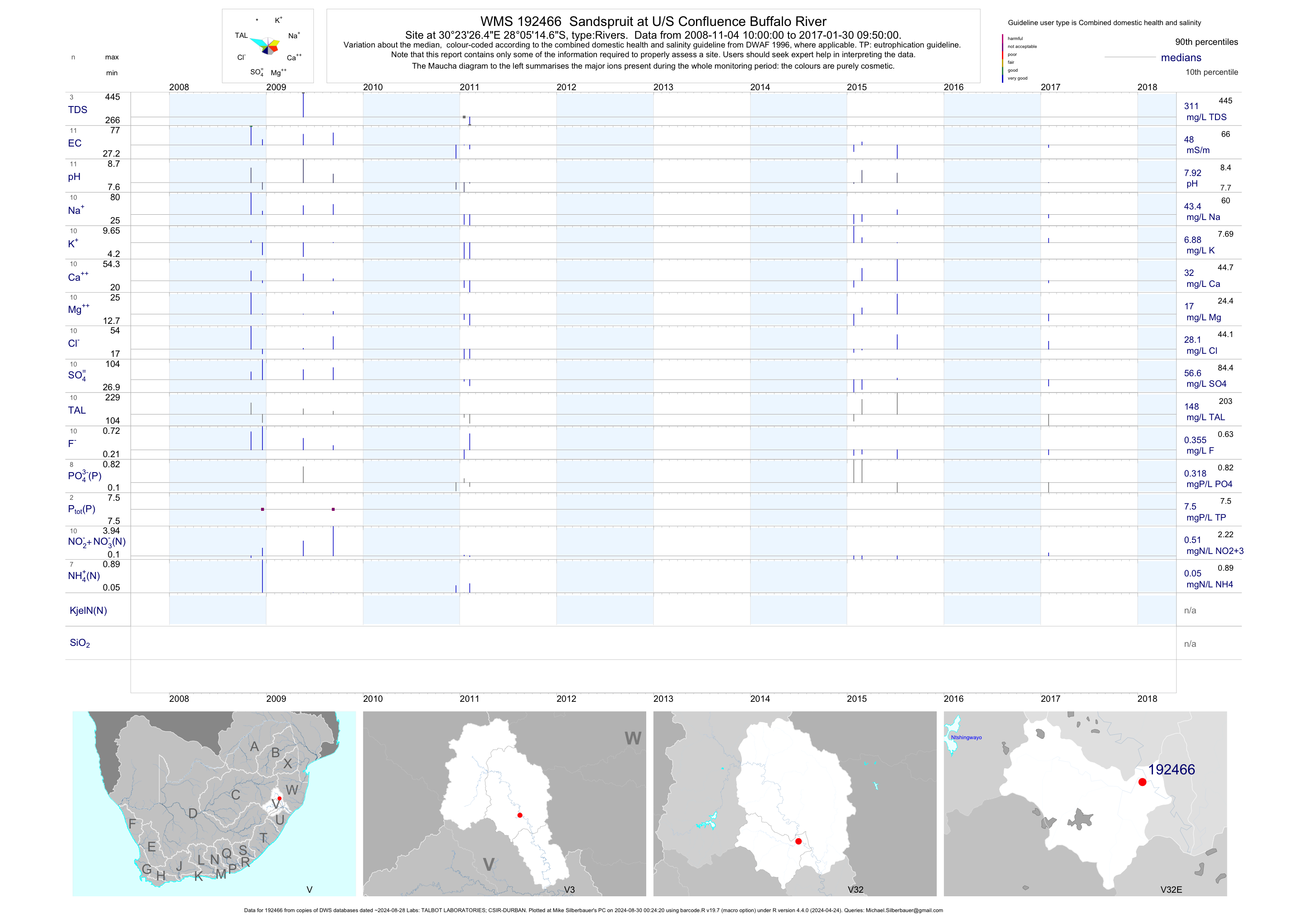
| V32 192466 | plot | data | Sandspruit at U/S Confluence Buffalo River | Rivers | 8 | 2008-11-04 | 2017-01-30 | 52 | 192466 | -28.08739 | 30.39067 |
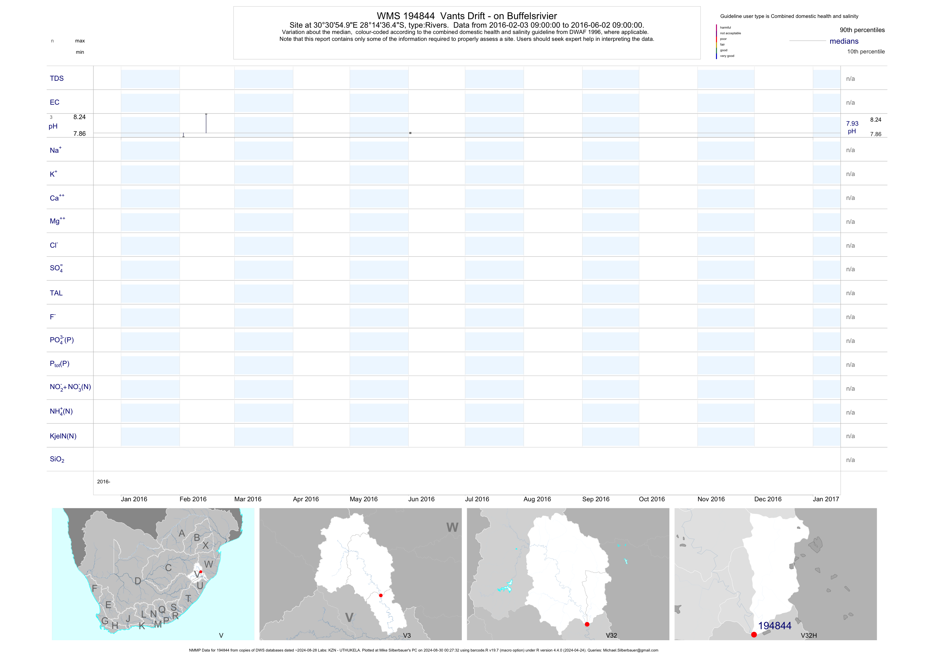
| V32 194844 | plot | data | Vants Drift - on Buffelsrivier (NMMP) | Rivers | 9 | 2016-02-03 | 2016-06-02 | n/a | 194844 | -28.24346 | 30.51527 |
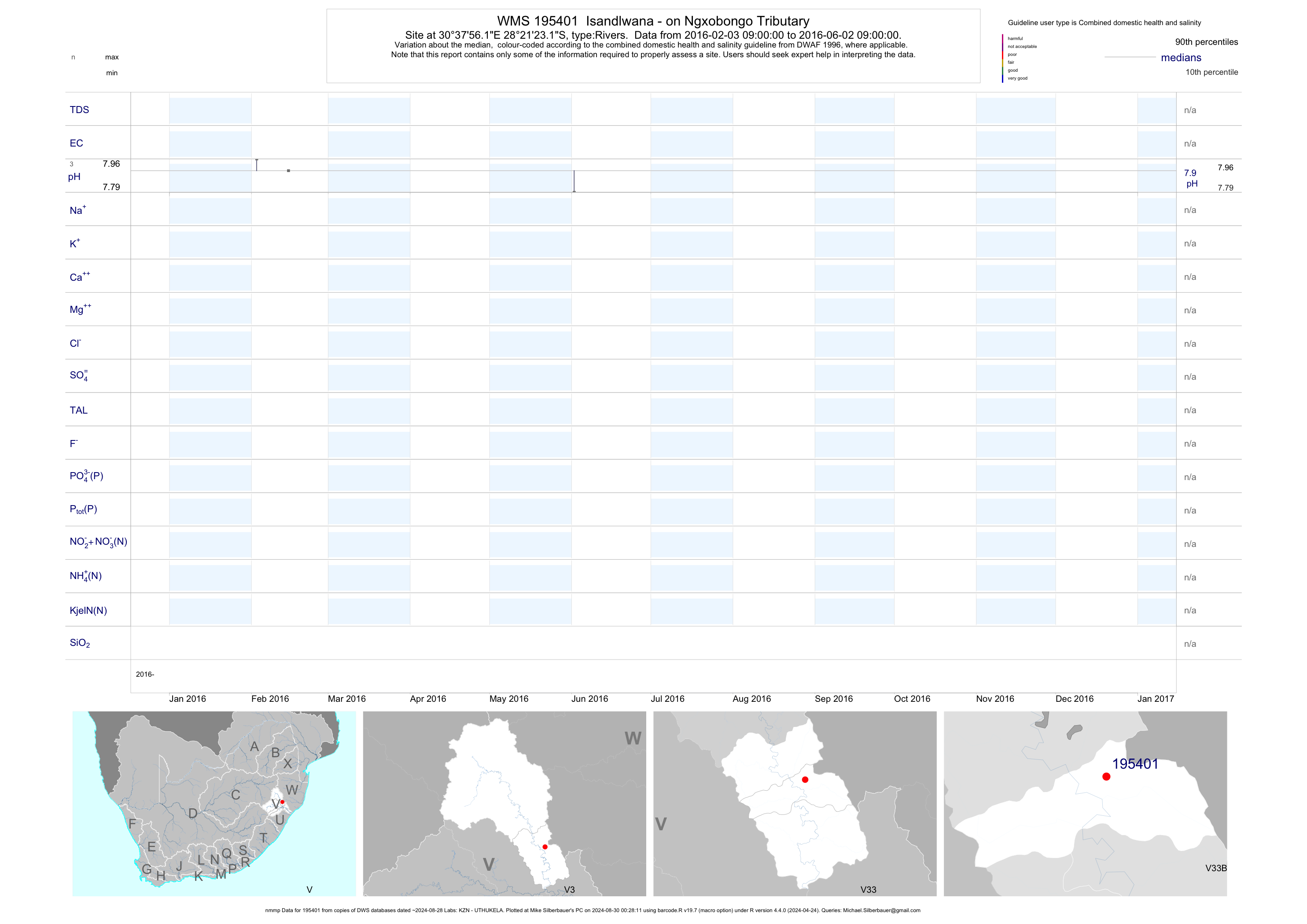
| V33 195401 | plot | data | Isandlwana - on Ngxobongo Tributary (nmmp) | Rivers | 9 | 2016-02-03 | 2016-06-02 | n/a | 195401 | -28.35643 | 30.63225 |
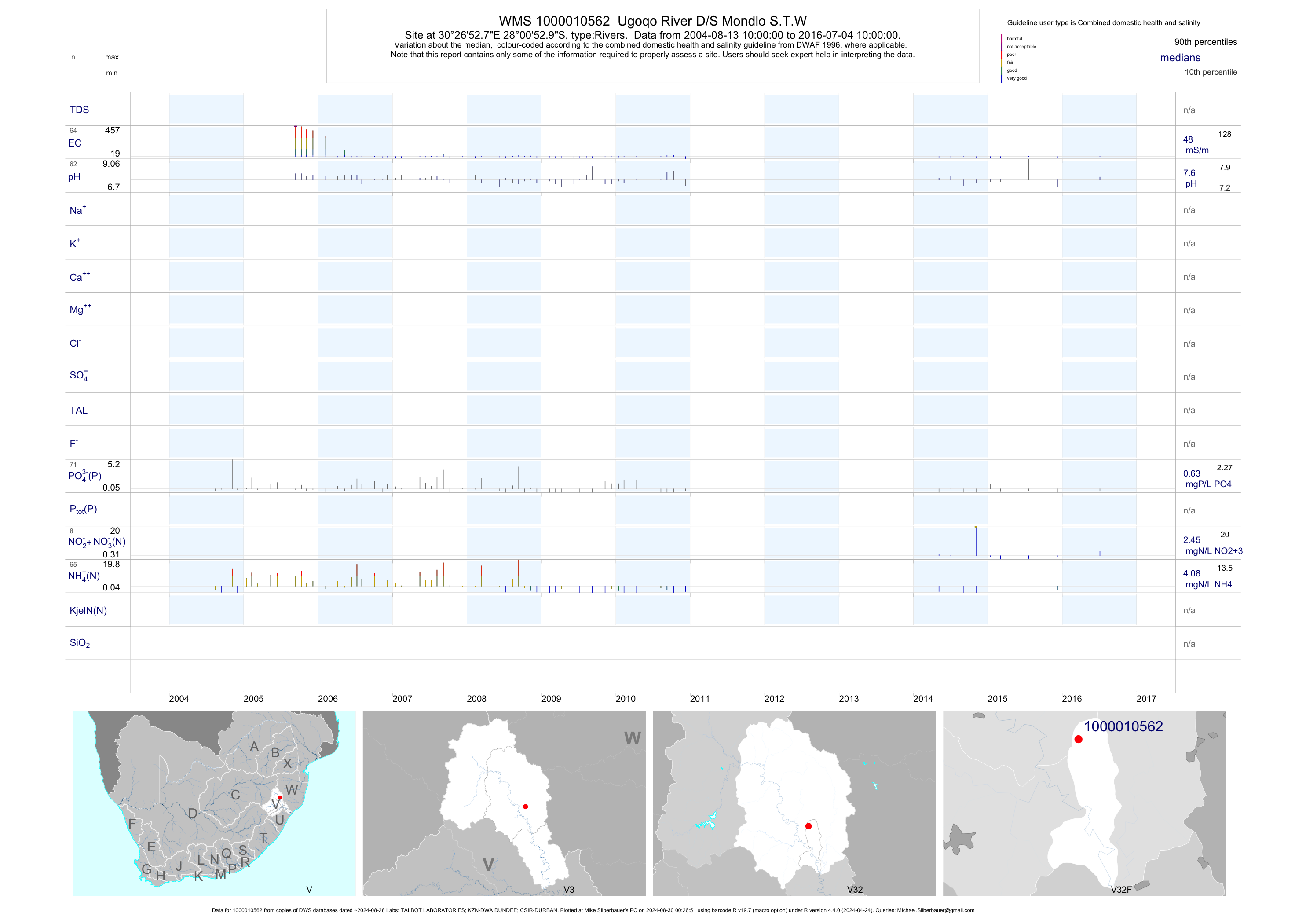
| V32 1000010562 | plot | data | Ugoqo River D/S Mondlo S.T.W | Rivers | 128 | 2004-08-12 | 2016-10-17 | 48 | 1-10562 | -28.01471 | 30.44798 |
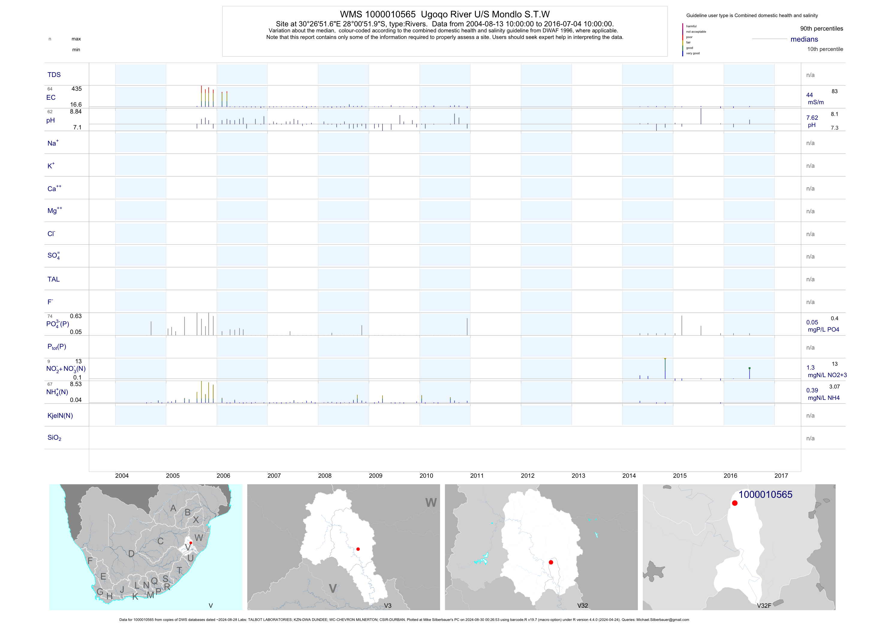
| V32 1000010565 | plot | data | Ugoqo River U/S Mondlo S.T.W | Rivers | 132 | 2004-08-12 | 2016-12-07 | 44 | 1-10565 | -28.01444 | 30.44767 |
| V32 1000010650 | plot | data | Ubhobhojane River U/S Nquthu STW | Rivers | 110 | 2004-08-13 | 2010-08-10 | 46 | 1-10650 | -28.12338 | 30.40474 |
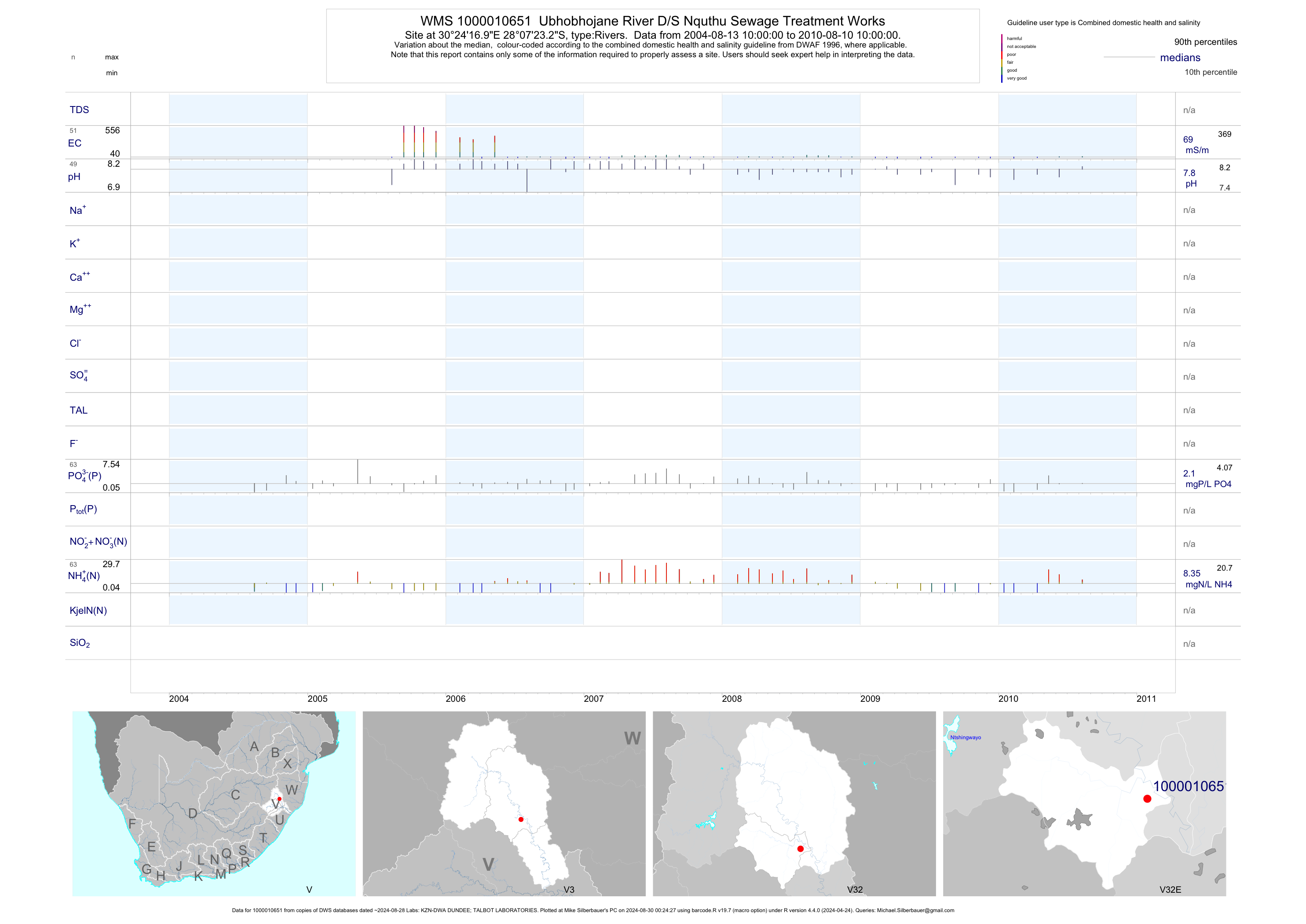
| V32 1000010651 | plot | data | Ubhobhojane River D/S Nquthu Sewage Treatment Works | Rivers | 102 | 2004-08-13 | 2010-08-10 | 69 | 1-10651 | -28.12312 | 30.40470 |
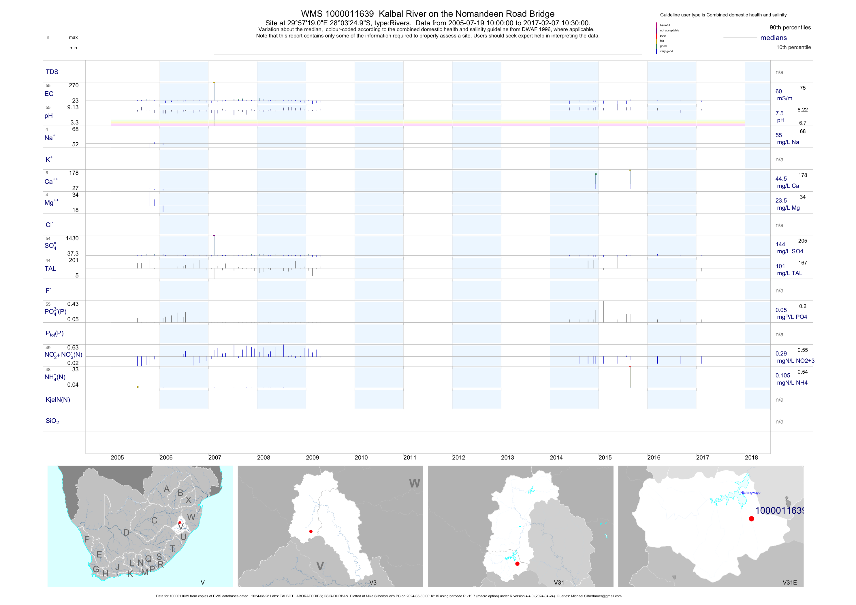
| V31 1000011639 | plot | data | Kalbal River on the Nomandeen Road Bridge | Rivers | 71 | 2005-07-19 | 2017-02-07 | 61 | 1-11639 | -28.05694 | 29.95528 |
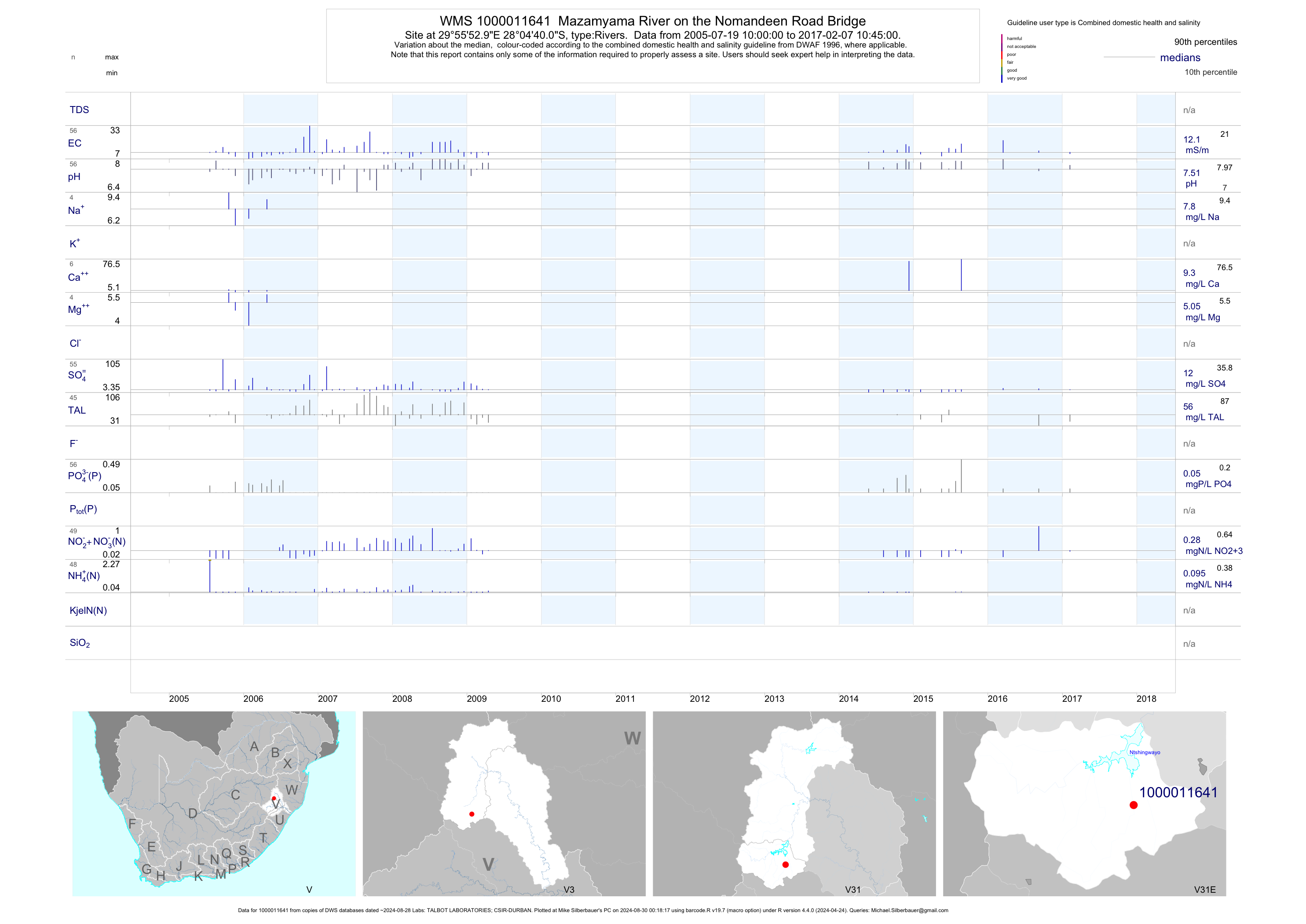
| V31 1000011641 | plot | data | Mazamyama River on the Nomandeen Road Bridge | Rivers | 72 | 2005-07-19 | 2017-02-07 | 12 | 1-11641 | -28.07778 | 29.93139 |
| V31 1000011643 | plot | data | Mhlonyana River on the Nomandeen Road Bridge | Rivers | 74 | 2005-07-19 | 2017-02-07 | 17 | 1-11643 | -28.06361 | 29.84333 |
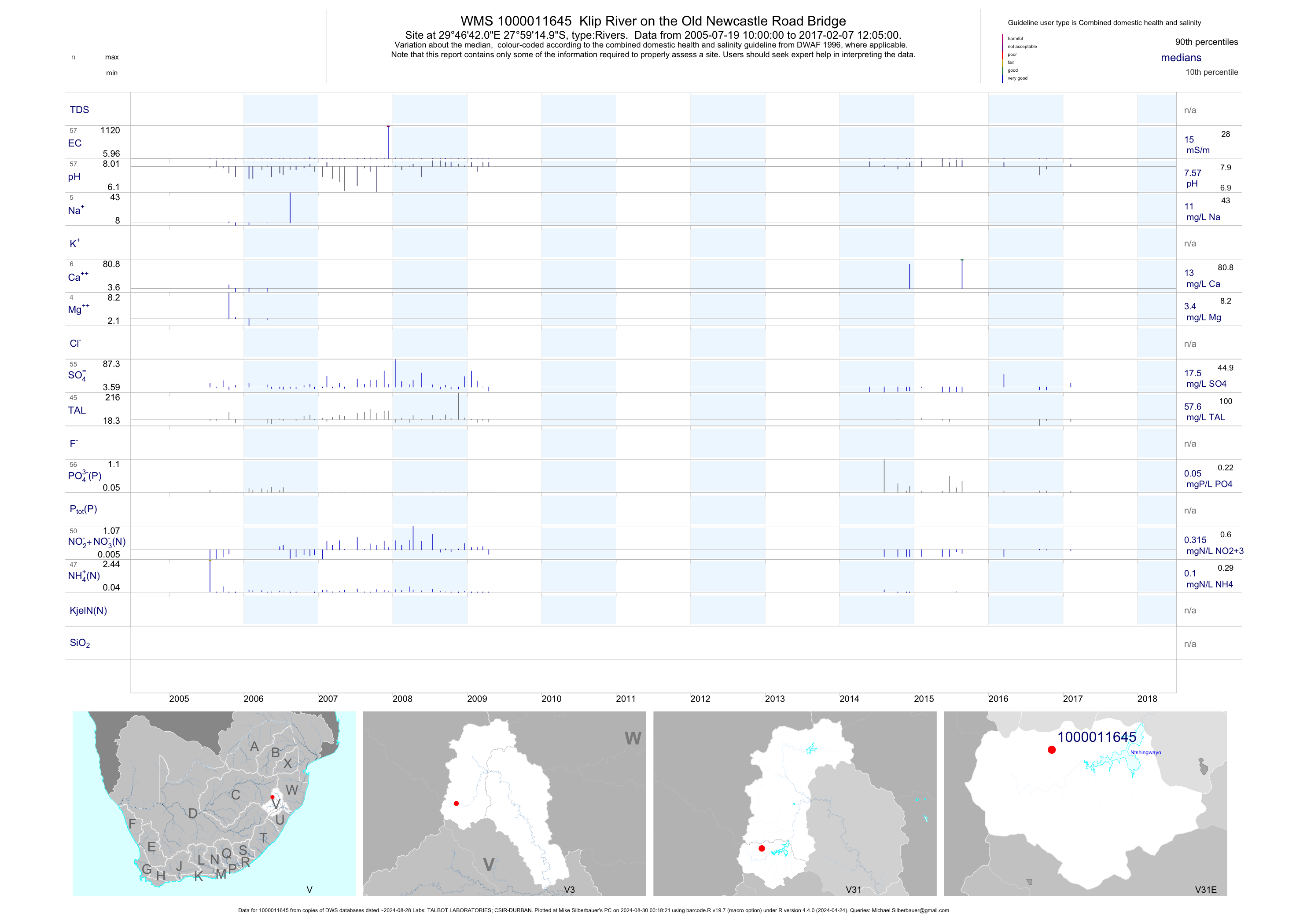
| V31 1000011645 | plot | data | Klip River on the Old Newcastle Road Bridge | Rivers | 71 | 2005-07-19 | 2017-02-07 | 15 | 1-11645 | -27.98750 | 29.77833 |
| V31 1000011646 | plot | data | Ngagane River on the Old Newcastle Road Bridge | Rivers | 75 | 2005-07-19 | 2017-02-07 | 16 | 1-11646 | -28.04083 | 29.78667 |
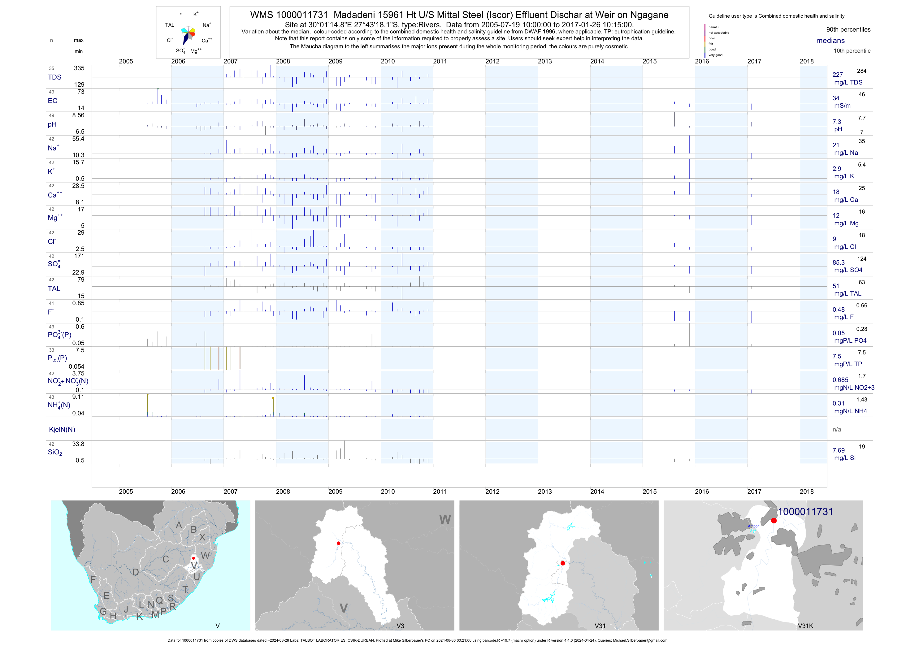
| V31 1000011731 | plot | data | Madadeni 15961 Ht U/S Mittal Steel (Iscor) Effluent Dischar at Weir on Ngagane | Rivers | 57 | 2005-07-19 | 2017-01-26 | 34 | 1-11731 | -27.72170 | 30.02078 |
| V31 1000011734 | plot | data | Madadeni 15961 Ht D/S Mittal Steel (Iscor) Effluent Discharge Point on Ngagane | Rivers | 64 | 2005-07-19 | 2017-01-26 | 42 | 1-11734 | -27.72662 | 30.05457 |
| V40 88972 | n/a | n/a | ZTUGMID01 Tugela River at Middeldrift (Tugela-Mhlatuze Gws) | Rivers | 132 | 1994-10-27 | 1999-07-29 | n/a | 88972 | -28.89583 | 31.02667 |
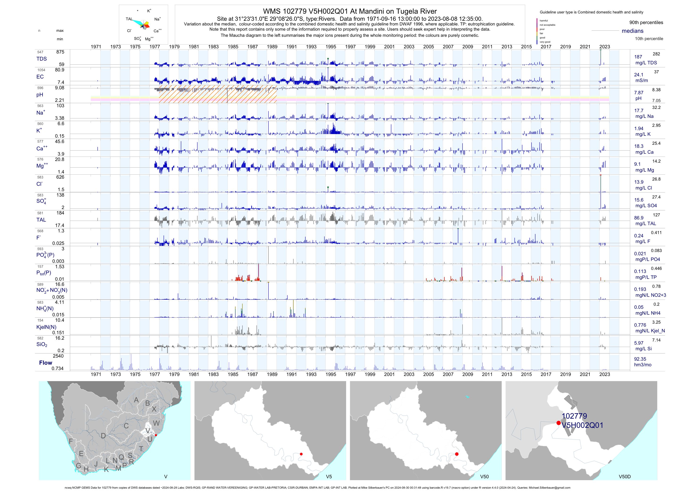
| V50 102779 | plot | data | At Mandini on Tugela River (ncwq NCMP GEMS) | Rivers | 1777 | 1971-01-13 | 2018-05-17 | 24 | V5H002 | -29.14056 | 31.39194 |
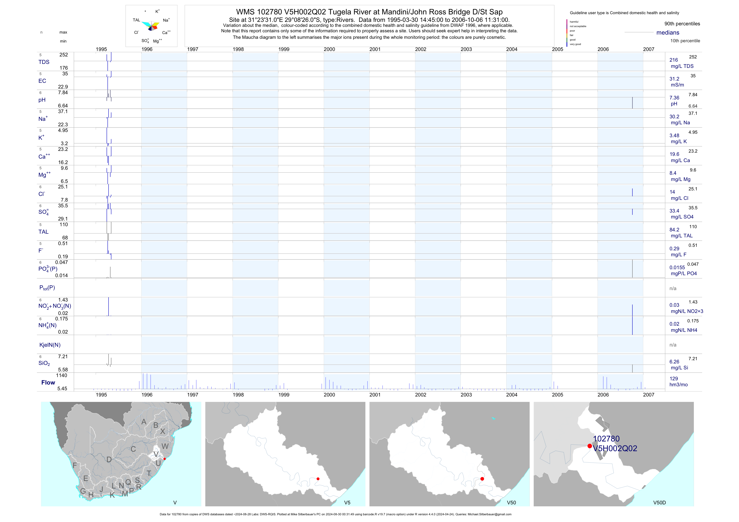
| V50 102780 | plot | data | Tugela River at Mandini/John Ross Bridge D/St Sap | Rivers | 6 | 1995-03-30 | 2006-10-06 | 31 | V5H002 | -29.14056 | 31.39194 |
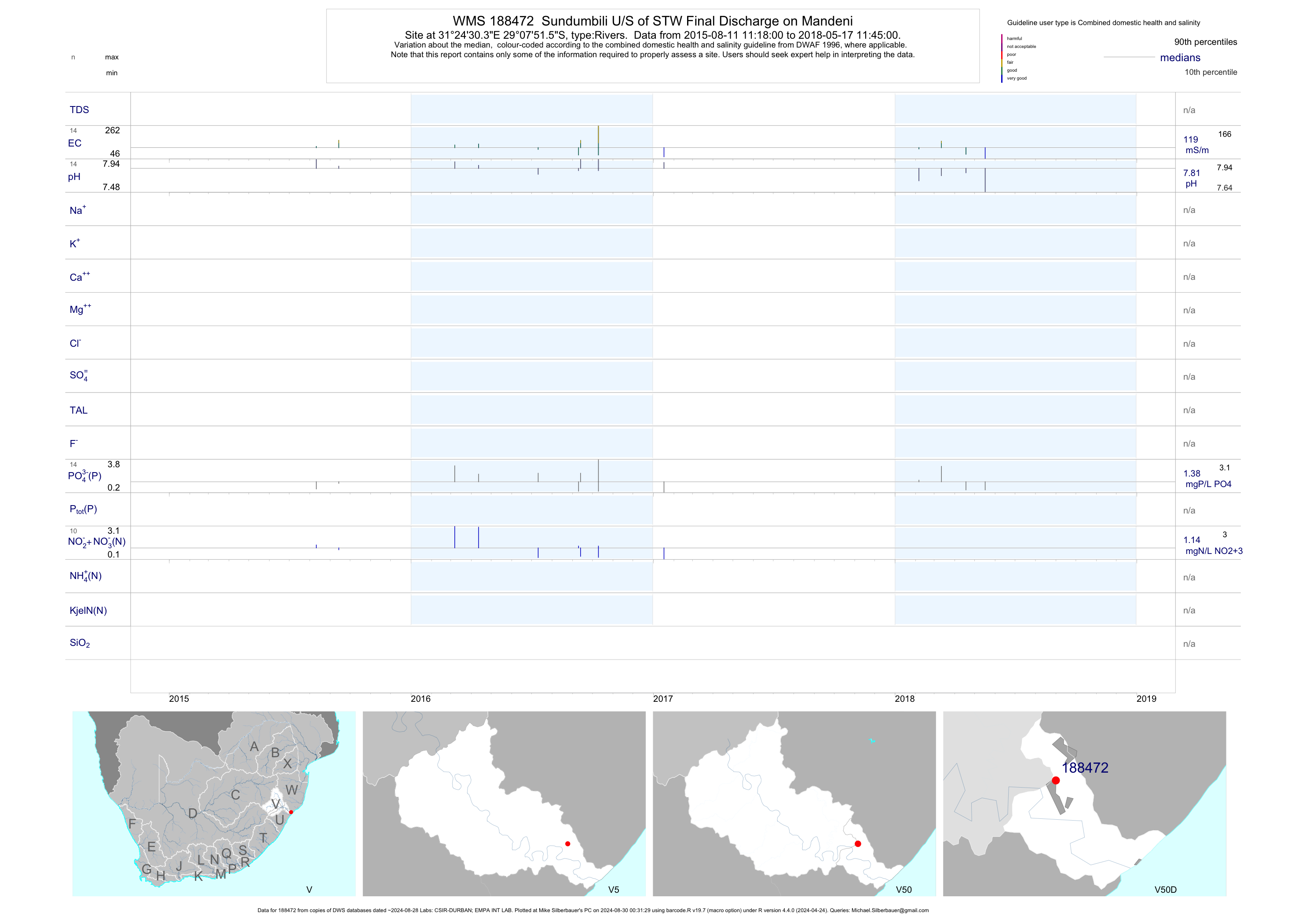
| V50 188472 | plot | data | Sundumbili U/S of STW Final Discharge on Mandeni | Rivers | 28 | 2015-04-07 | 2018-05-17 | 127 | 188472 | -29.13098 | 31.40843 |
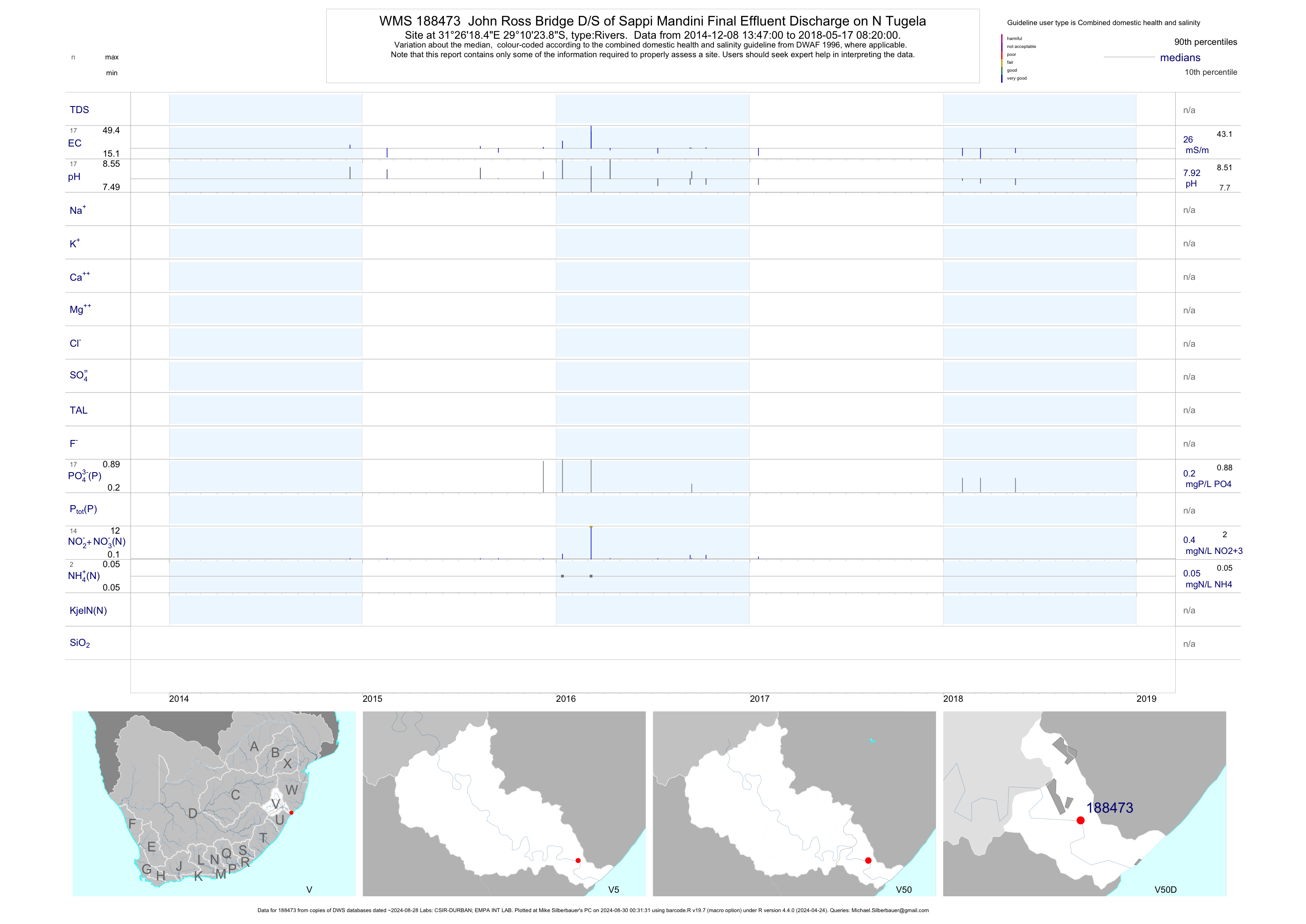
| V50 188473 | plot | data | John Ross Bridge D/S of Sappi Mandini Final Effluent Discharge on N Tugela | Rivers | 16 | 2014-10-14 | 2018-05-17 | 24 | 188473 | -29.17330 | 31.43847 |
| V50 188475 | plot | data | Sundumbili D/S of Sundumbili STW on Mandeni | Rivers | 28 | 2015-04-07 | 2018-05-17 | 149 | 188475 | -29.13705 | 31.40628 |
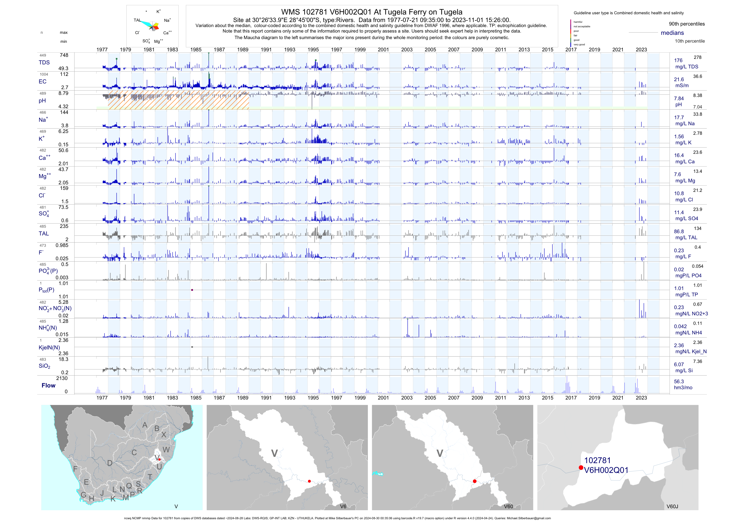
| V60 102781 | plot | data | At Tugela Ferry on Tugela (ncwq NCMP nmmp) | Rivers | 1023 | 1977-07-21 | 2018-04-19 | 22 | V6H002 | -28.75000 | 30.44278 |
| V60 102782 | plot | data | Wasbank River at Kuick Vlei (NCWQ) | Rivers | 734 | 1977-07-21 | 2018-03-20 | 89 | V6H003 | -28.30944 | 30.14806 |
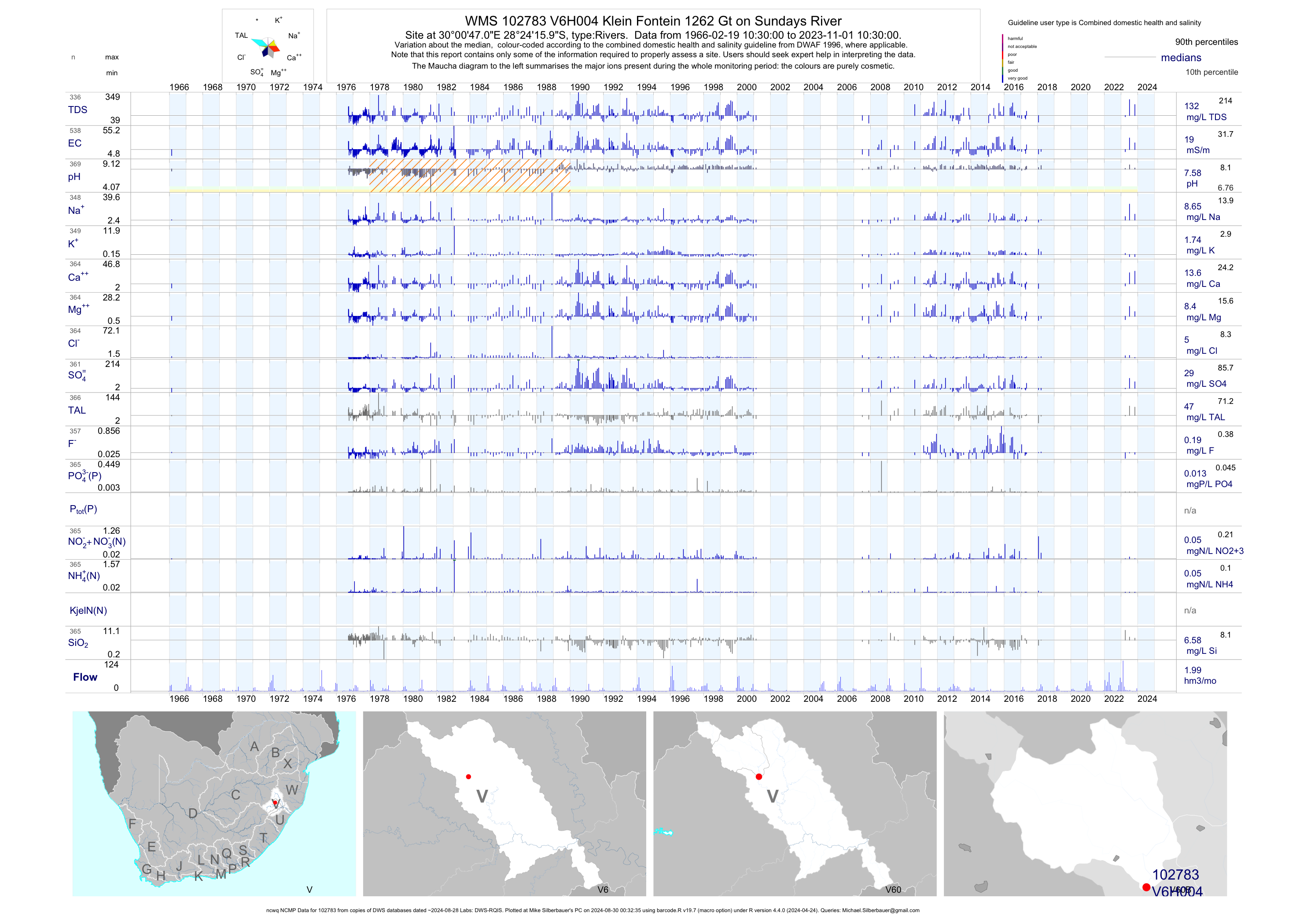
| V60 102783 | plot | data | Klein Fontein 1262 Gt on Sundays River (ncwq NCMP) | Rivers | 537 | 1966-02-19 | 2018-03-20 | 19 | V6H004 | -28.40444 | 30.01306 |
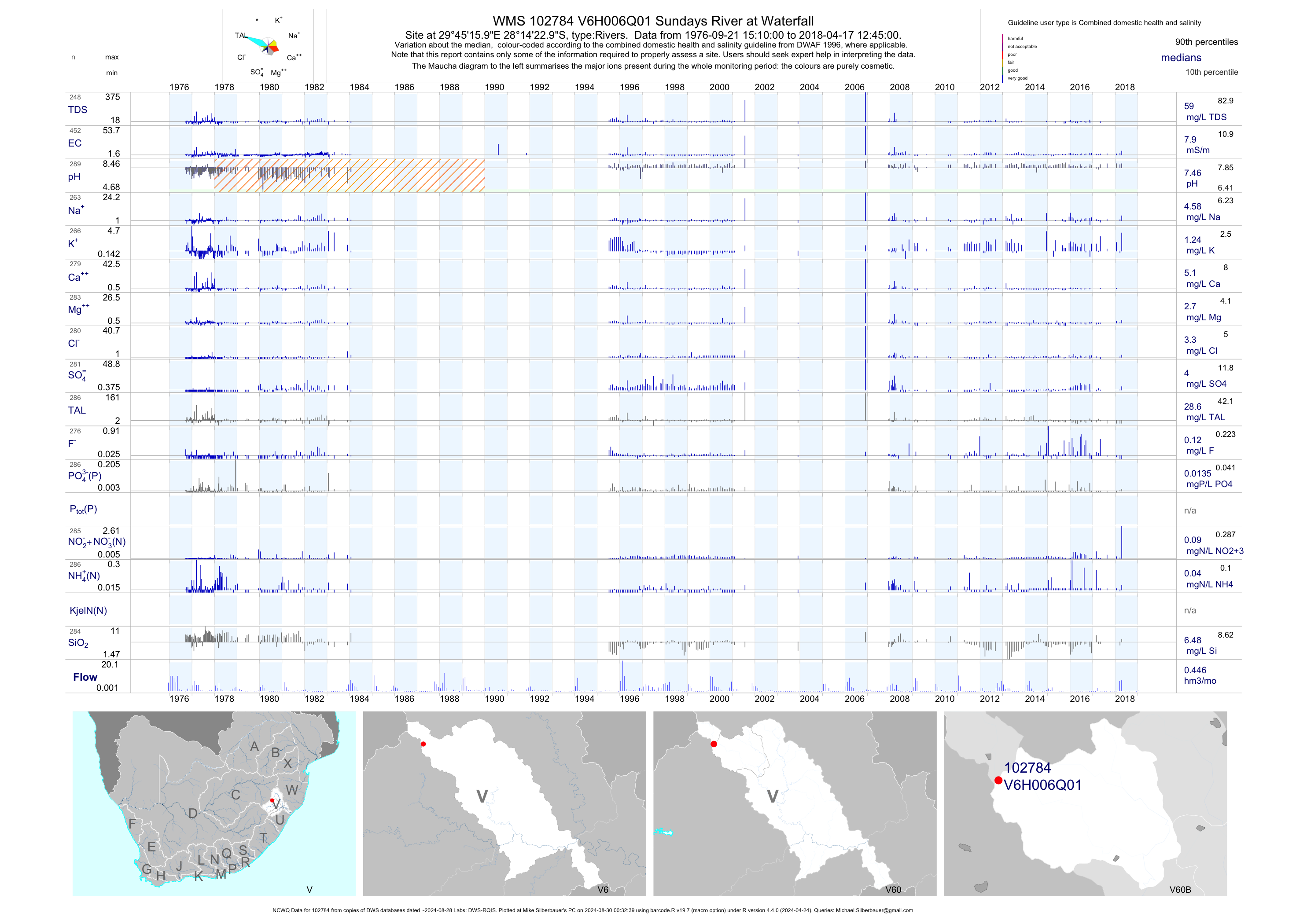
| V60 102784 | plot | data | Sundays River at Waterfall (NCWQ) | Rivers | 454 | 1976-09-21 | 2018-04-17 | 8 | V6H006 | -28.23972 | 29.75444 |
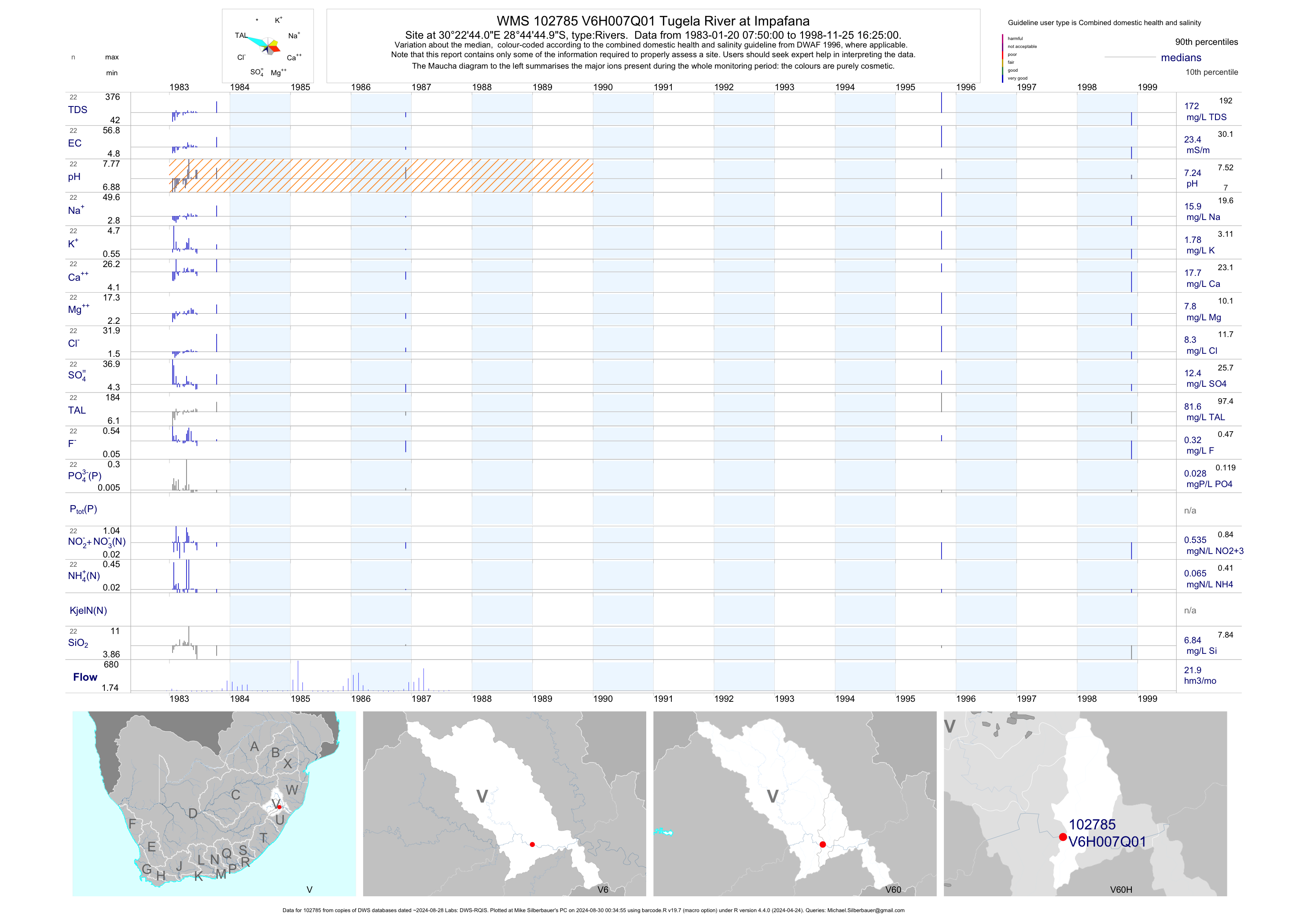
| V60 102785 | plot | data | Tugela River at Impafana | Rivers | 22 | 1983-01-20 | 1998-11-25 | 23 | V6H007 | -28.74583 | 30.37889 |
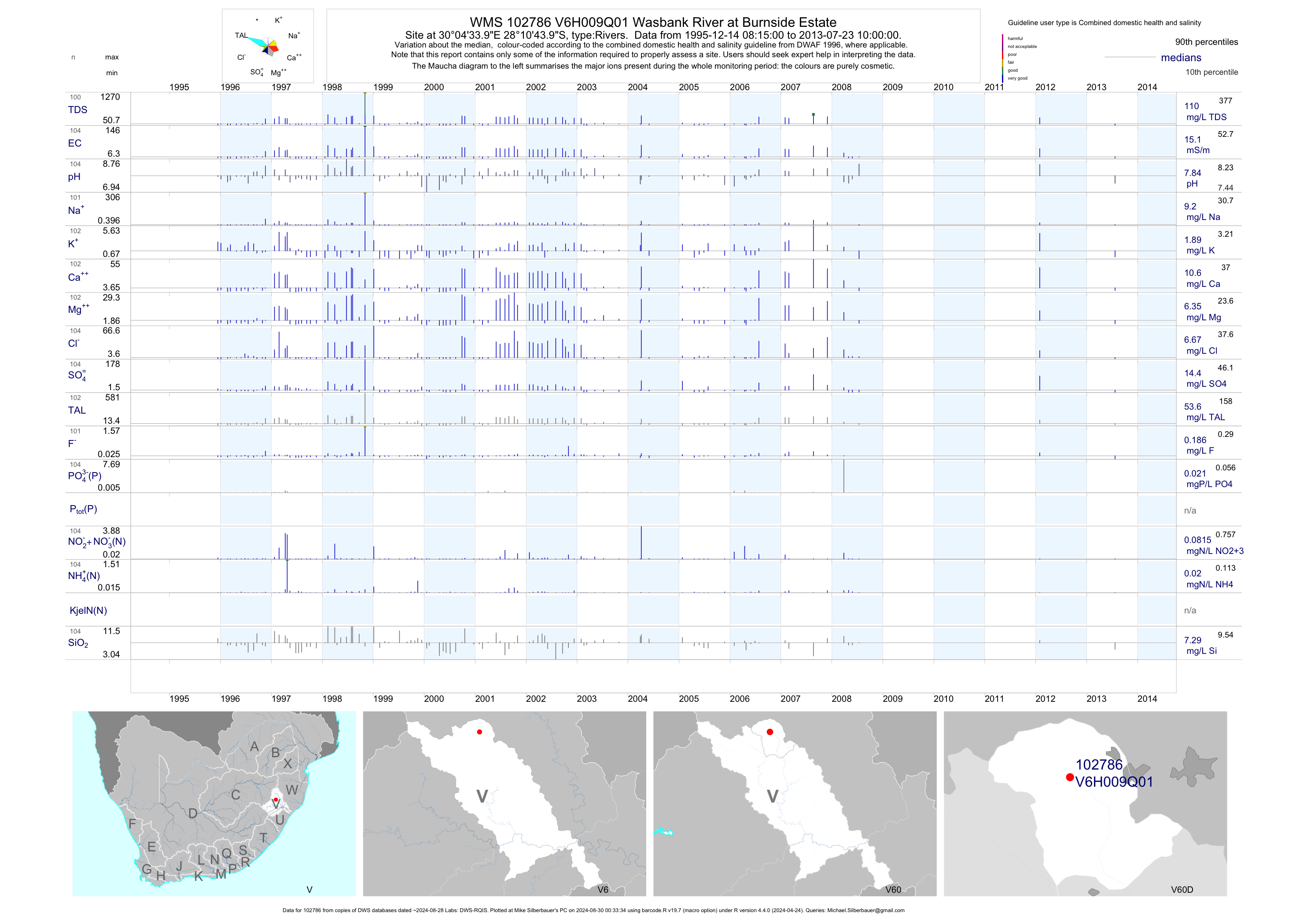
| V60 102786 | plot | data | Wasbank River at Burnside Estate | Rivers | 213 | 1995-12-14 | 2013-07-23 | 15 | V6H009 | -28.17889 | 30.07611 |
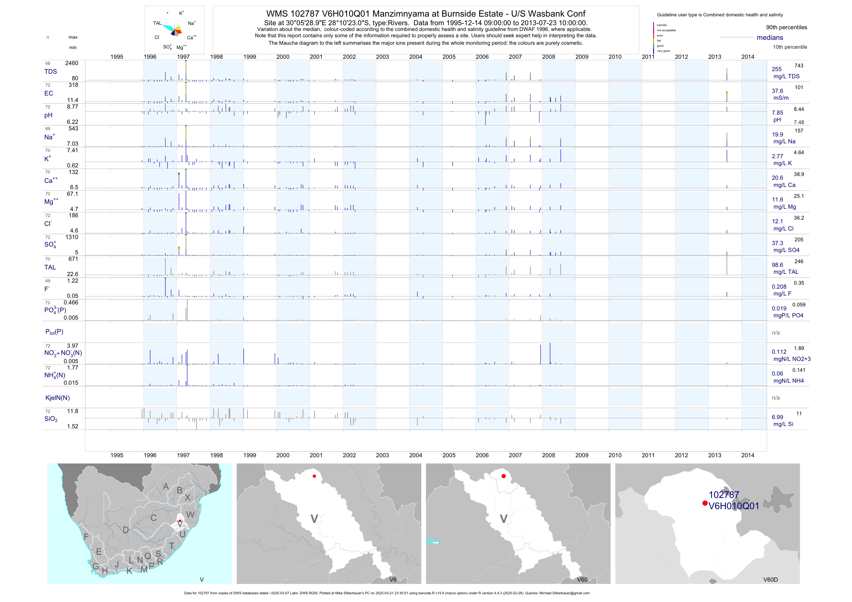
| V60 102787 | plot | data | Manzimnyama at Burnside Estate - U/S Wasbank Conf | Rivers | 146 | 1995-12-14 | 2013-07-23 | 38 | V6H010 | -28.17306 | 30.09139 |
| V60 102788 | plot | data | Wasbank Riv at Uithoek - U/S Uithoek Spruit D/S M | Rivers | 224 | 1995-12-14 | 2013-07-23 | 100 | V6H011 | -28.21250 | 30.12417 |
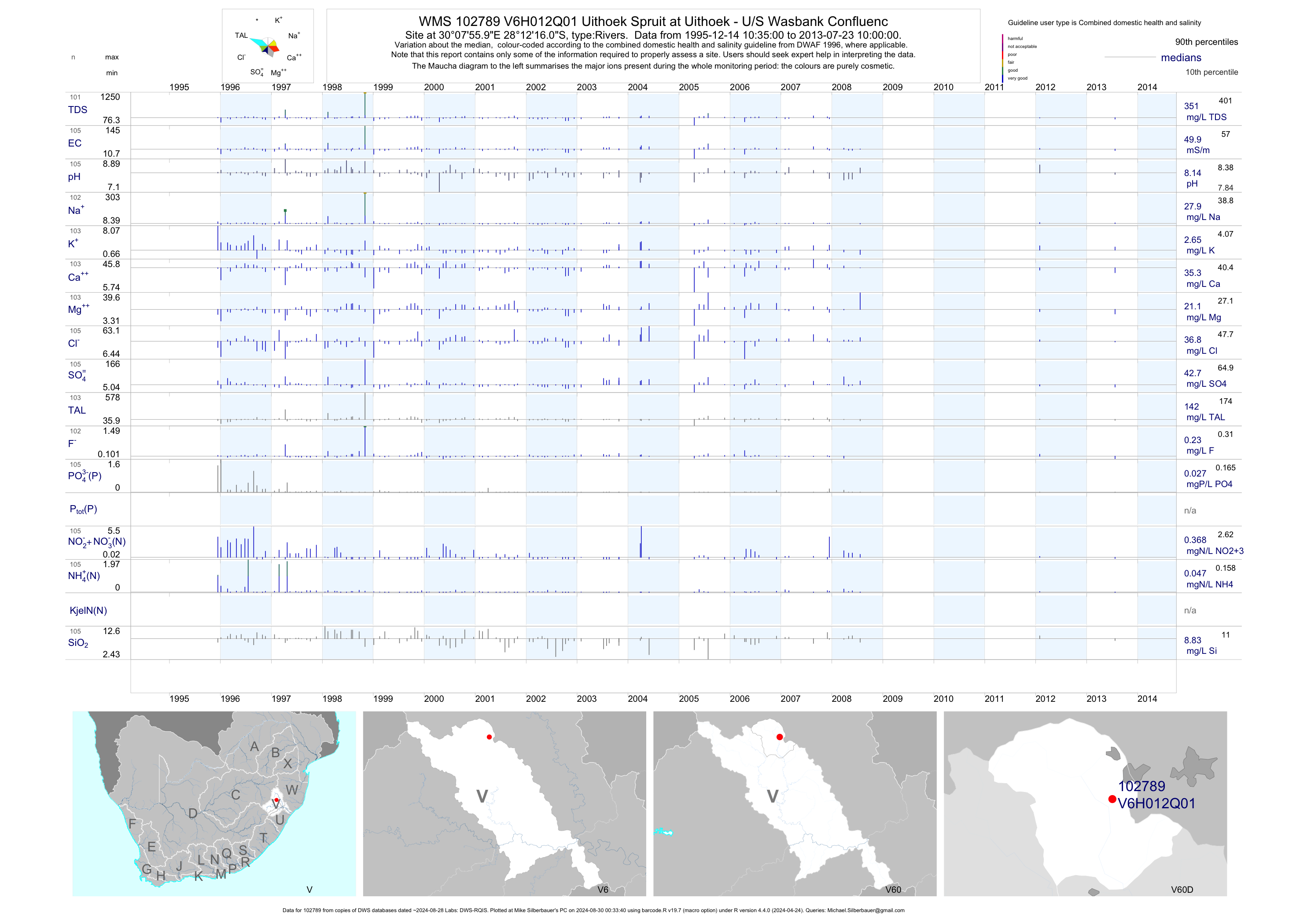
| V60 102789 | plot | data | Uithoek Spruit at Uithoek - U/S Wasbank Confluenc | Rivers | 212 | 1995-12-14 | 2013-07-23 | 50 | V6H012 | -28.20444 | 30.13222 |
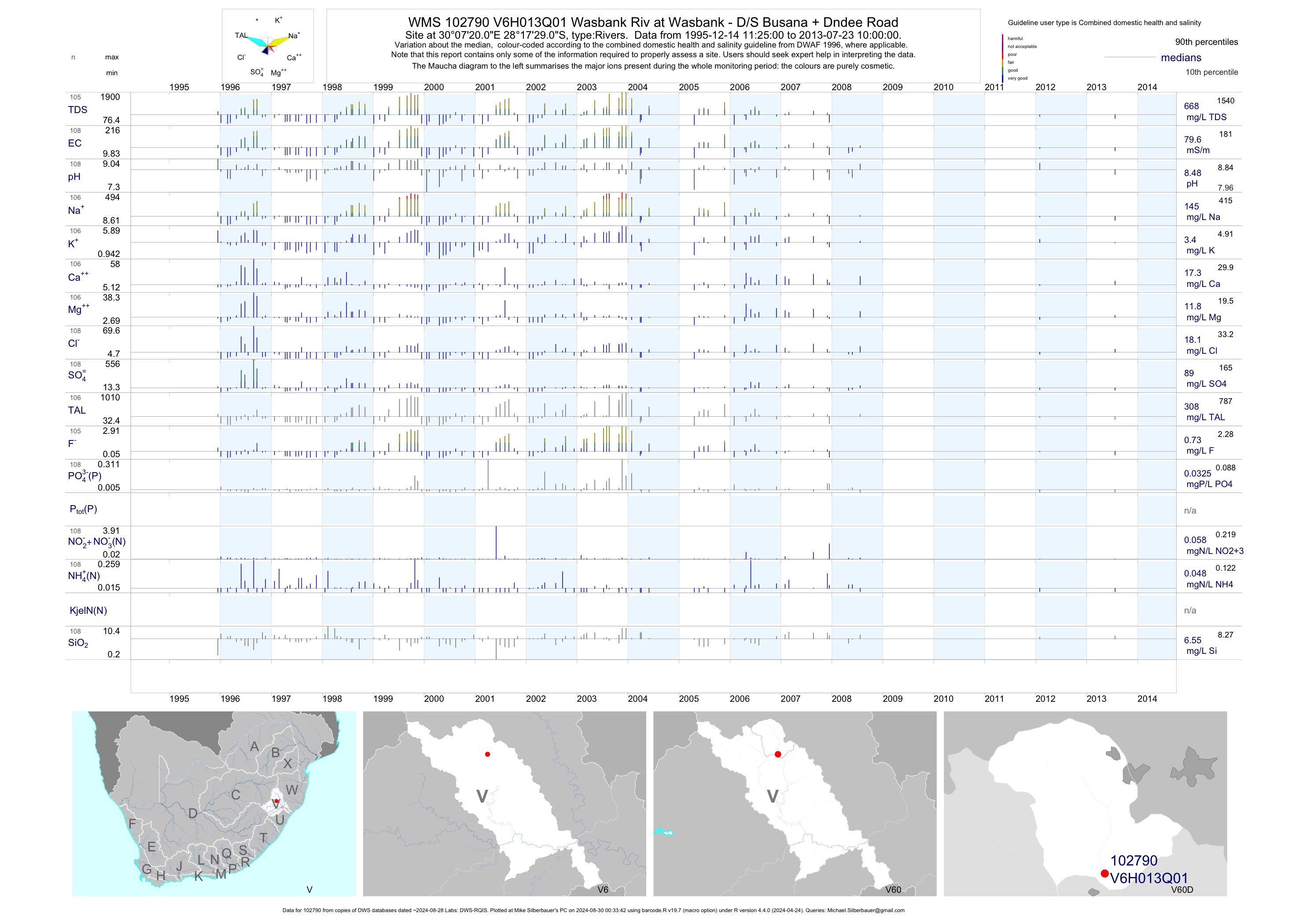
| V60 102790 | plot | data | Wasbank Riv at Wasbank - D/S Busana + Dndee Road | Rivers | 222 | 1995-12-14 | 2013-07-23 | 80 | V6H013 | -28.29139 | 30.12222 |
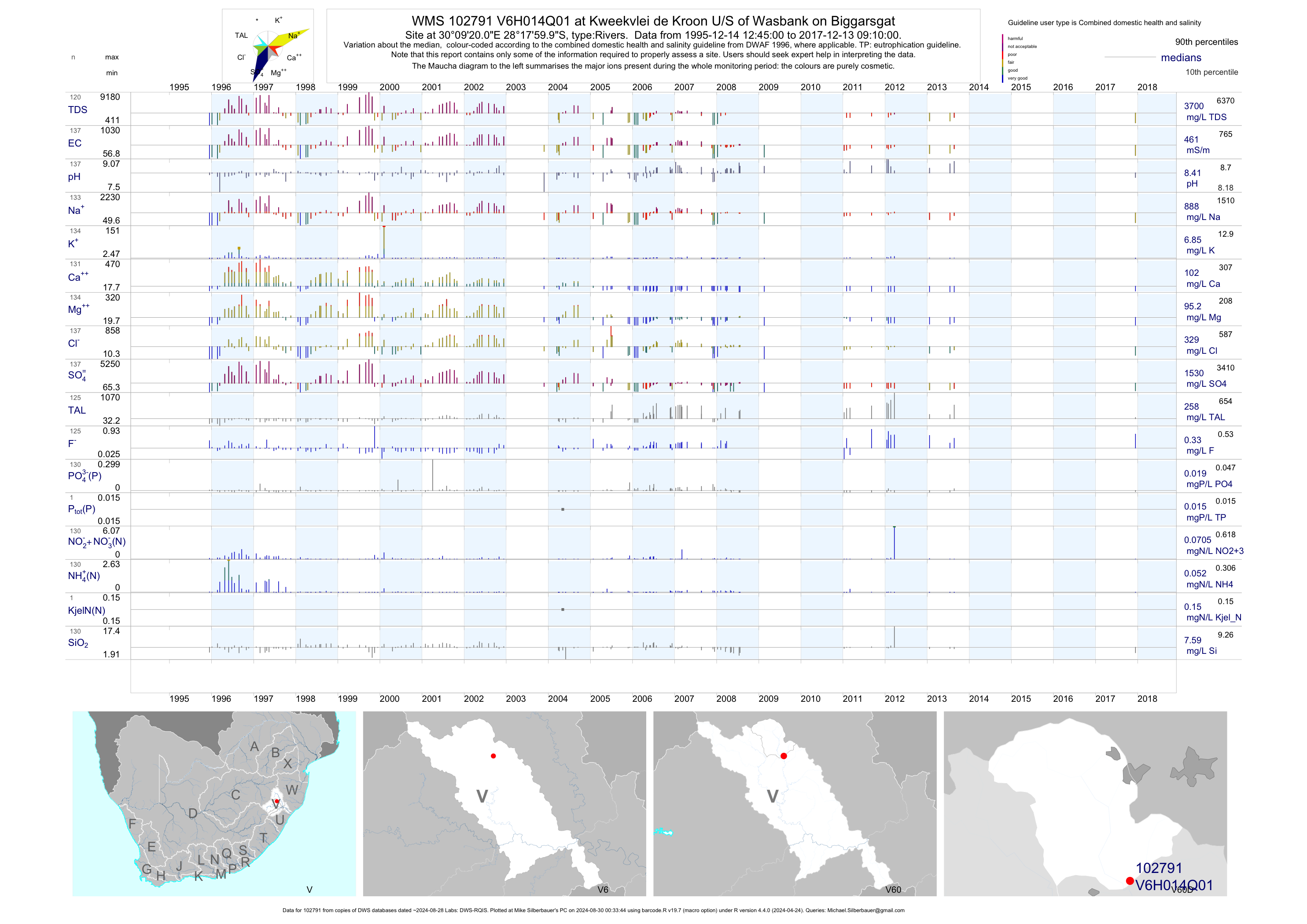
| V60 102791 | plot | data | at Kweekvlei de Kroon U/S of Wasbank on Biggarsgat | Rivers | 241 | 1995-12-14 | 2017-12-13 | 461 | V6H014 | -28.30000 | 30.15556 |
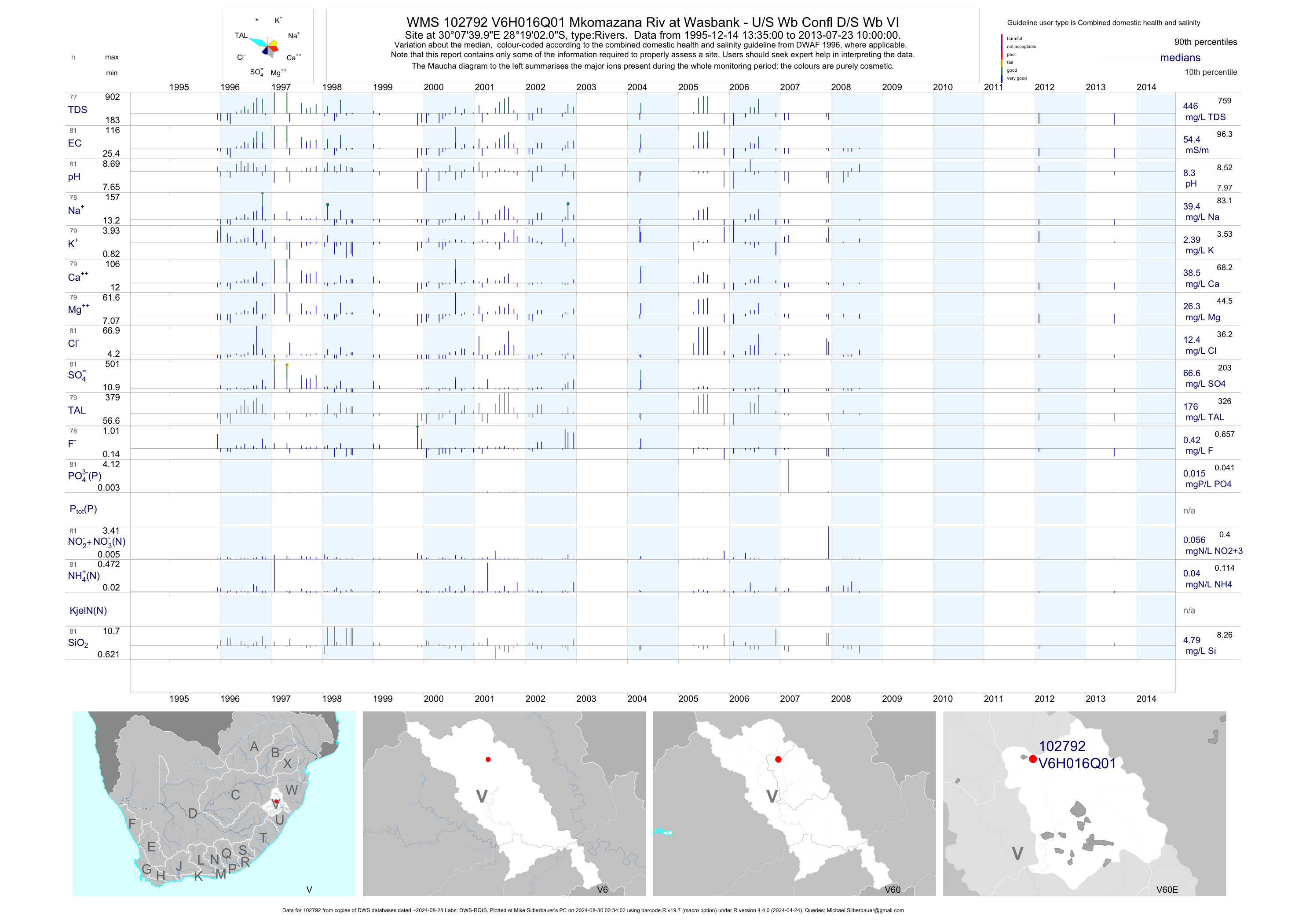
| V60 102792 | plot | data | Mkomazana Riv at Wasbank - U/S Wb Confl D/S Wb VI | Rivers | 164 | 1995-12-14 | 2013-07-23 | 54 | V6H016 | -28.31722 | 30.12778 |
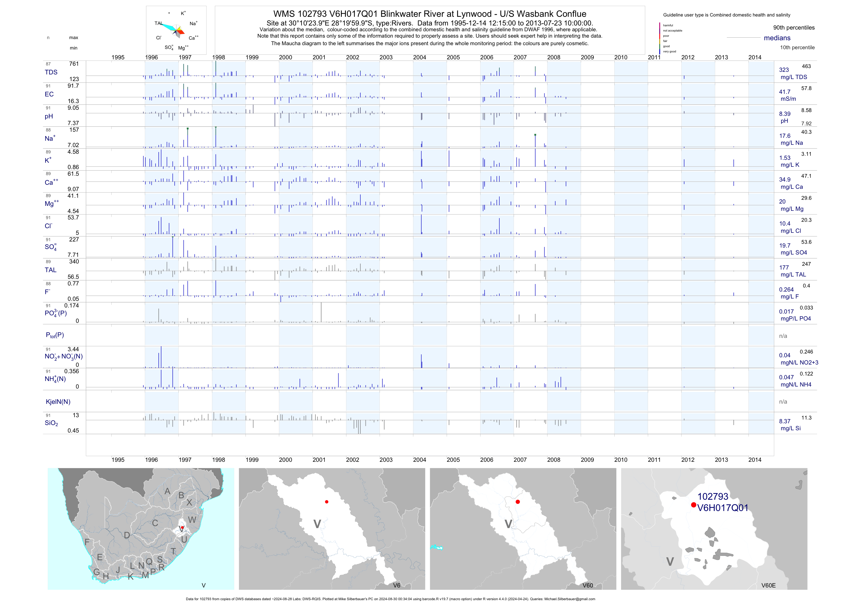
| V60 102793 | plot | data | Blinkwater River at Lynwood - U/S Wasbank Conflue | Rivers | 182 | 1995-12-14 | 2013-07-23 | 42 | V6H017 | -28.33333 | 30.17333 |
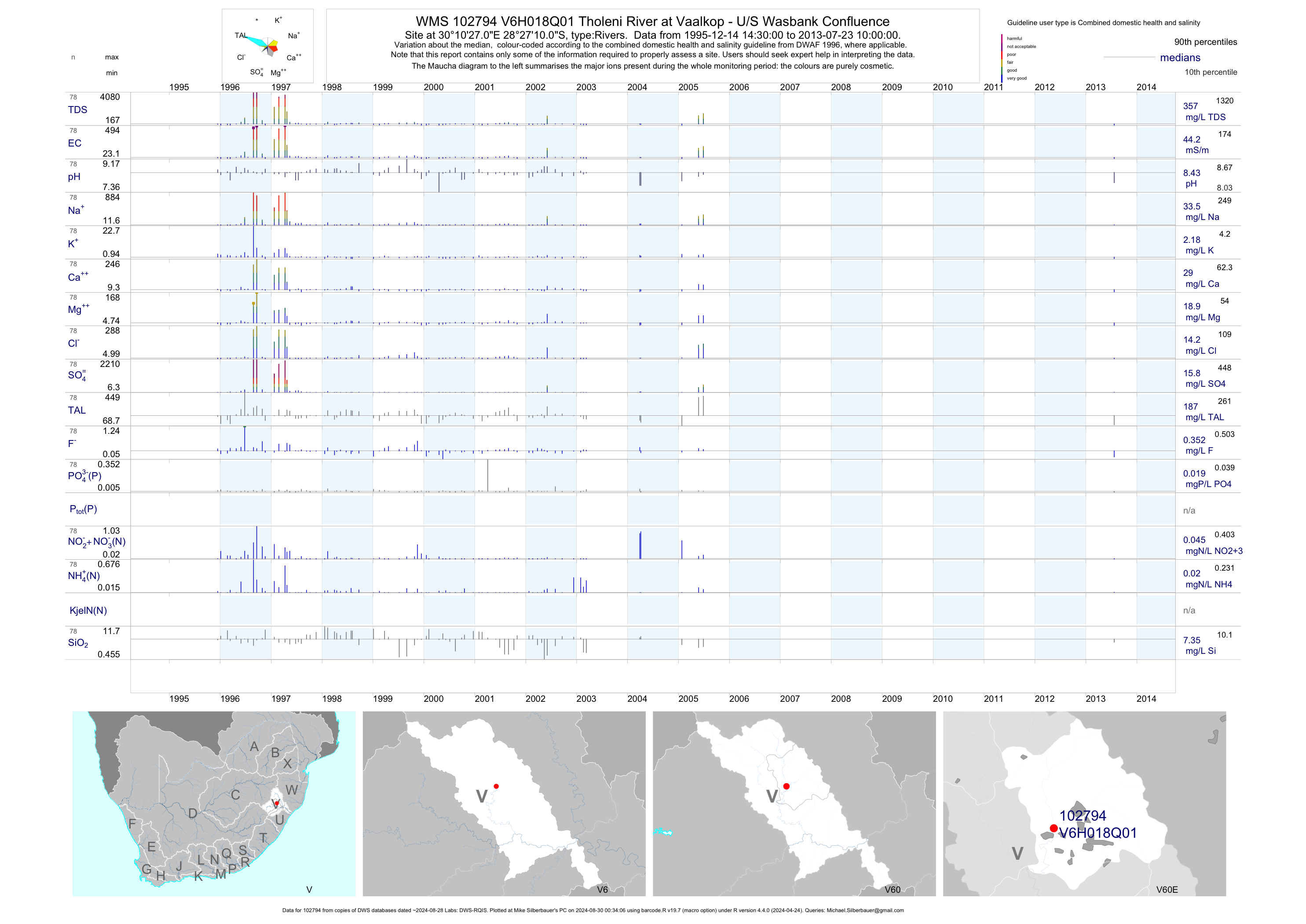
| V60 102794 | plot | data | Tholeni River at Vaalkop - U/S Wasbank Confluence | Rivers | 161 | 1995-12-14 | 2013-07-23 | 44 | V6H018 | -28.45278 | 30.17417 |
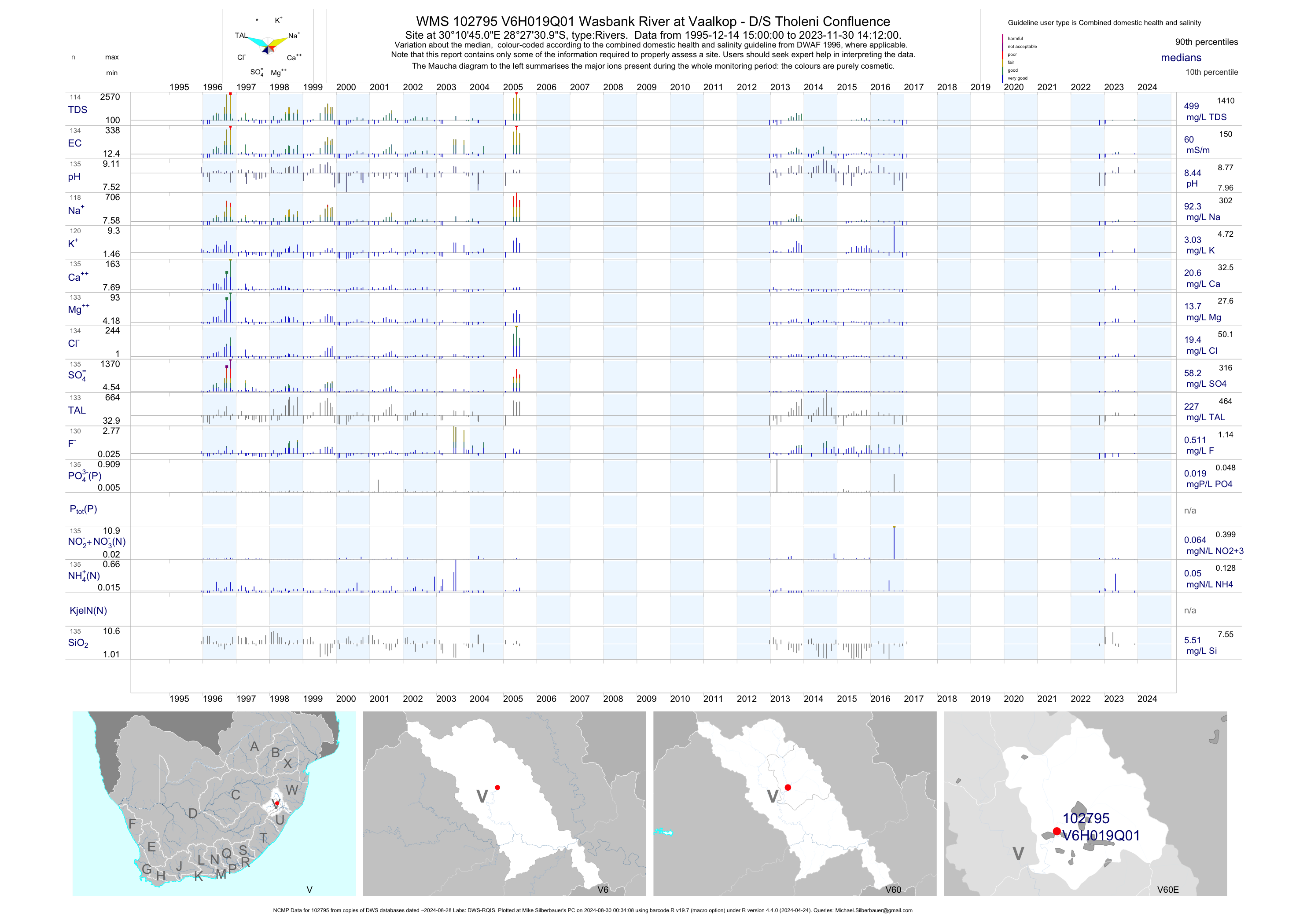
| V60 102795 | plot | data | Wasbank River at Vaalkop - D/S Tholeni Confluence (NCMP) | Rivers | 221 | 1995-12-14 | 2017-02-02 | 60 | V6H019 | -28.45861 | 30.17917 |
| V60 187700 | plot | data | #6 Biggarsgat upstream of Indumeni Decant | Rivers | 37 | 2003-11-25 | 2009-03-10 | 469 | 187700 | -28.25394 | 30.19250 |
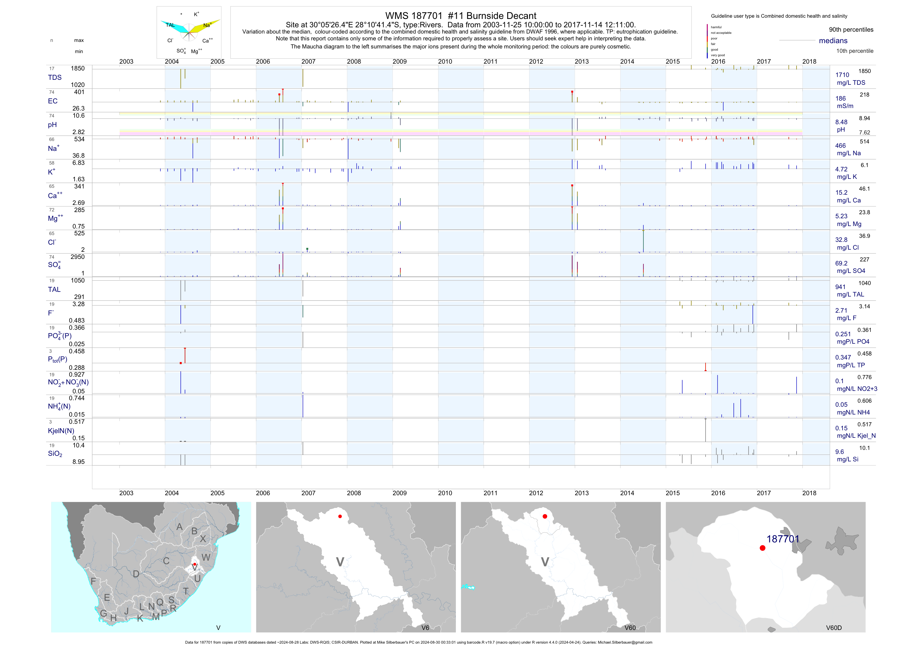
| V60 187701 | plot | data | #11 Burnside Decant | Rivers | 80 | 2003-11-25 | 2017-11-14 | 186 | 187701 | -28.17817 | 30.09067 |
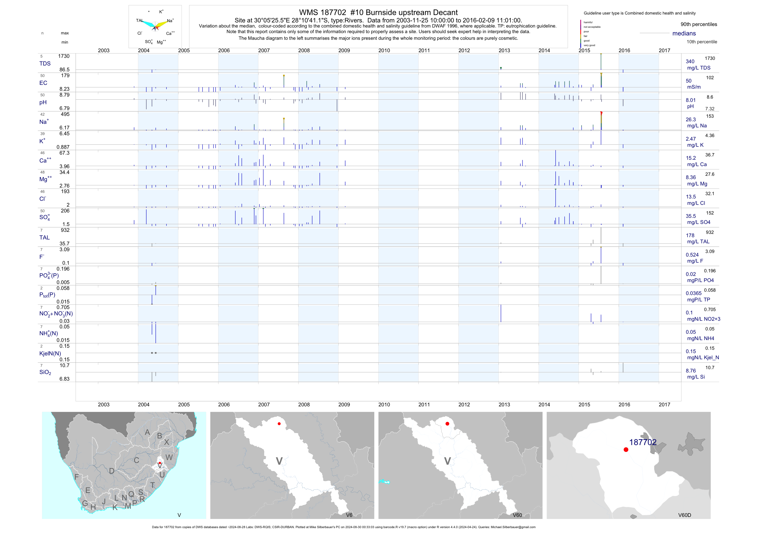
| V60 187702 | plot | data | #10 Burnside upstream Decant | Rivers | 54 | 2003-11-25 | 2016-02-09 | 50 | 187702 | -28.17811 | 30.09042 |
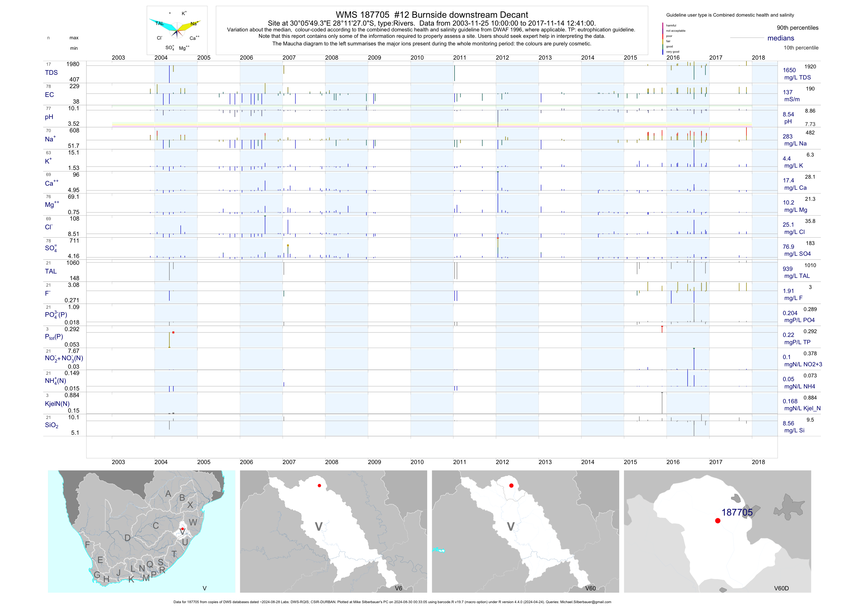
| V60 187705 | plot | data | #12 Burnside downstream Decant | Rivers | 88 | 2003-11-25 | 2017-11-14 | 137 | 187705 | -28.19086 | 30.09703 |
| V60 187709 | plot | data | #5 Biggarsgat Indumeni Pop Decant | Rivers | 93 | 2003-11-25 | 2017-12-13 | 599 | 187709 | -28.25464 | 30.19183 |
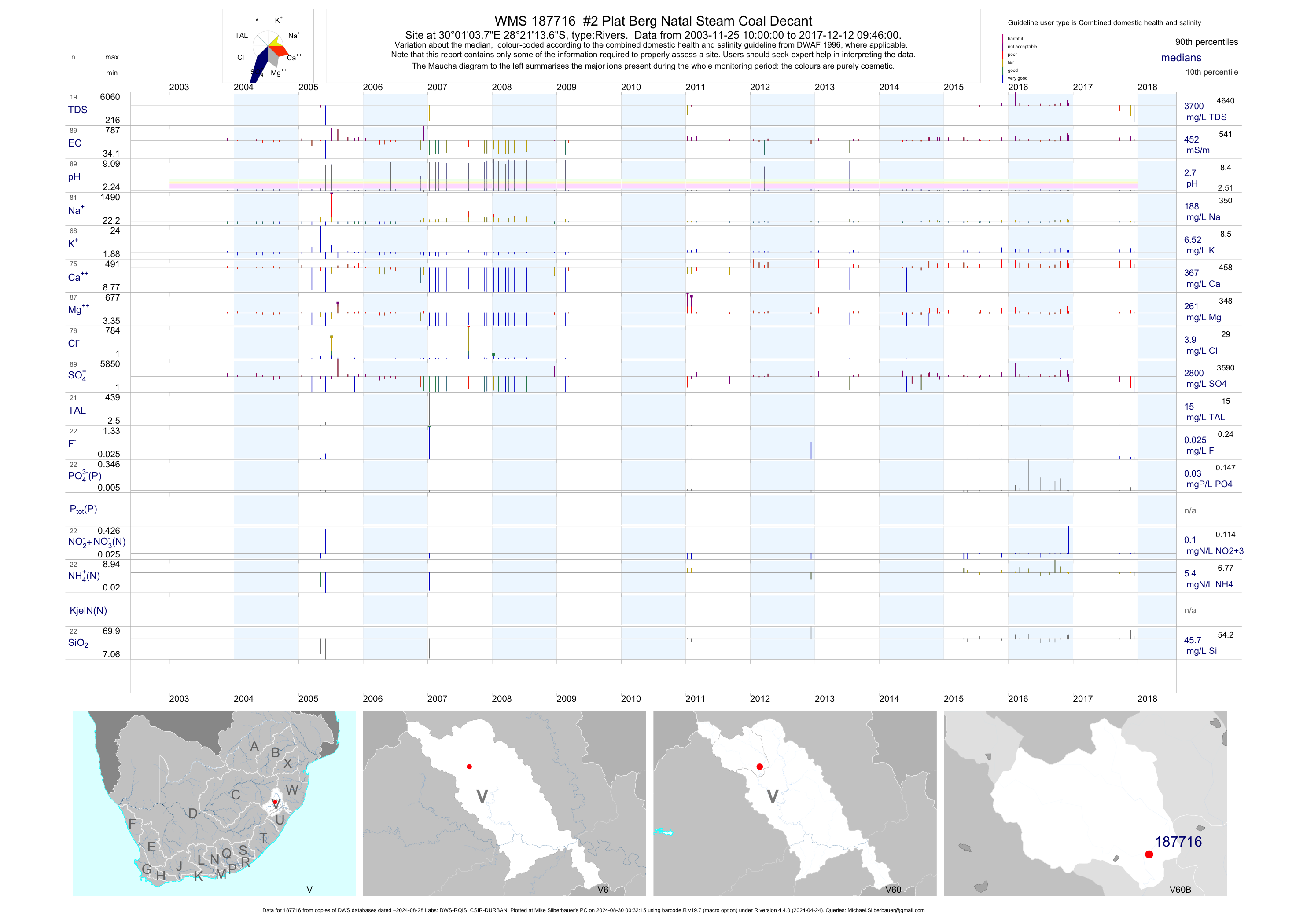
| V60 187716 | plot | data | #2 Plat Berg Natal Steam Coal Decant | Rivers | 100 | 2003-11-25 | 2017-12-12 | 452 | 187716 | -28.35381 | 30.01772 |
| V60 187722 | plot | data | #3 Plat Berg Down Stream of Natal Steam Coal Decant | Rivers | 99 | 2003-11-25 | 2017-12-12 | 89 | 187722 | -28.35392 | 30.01739 |
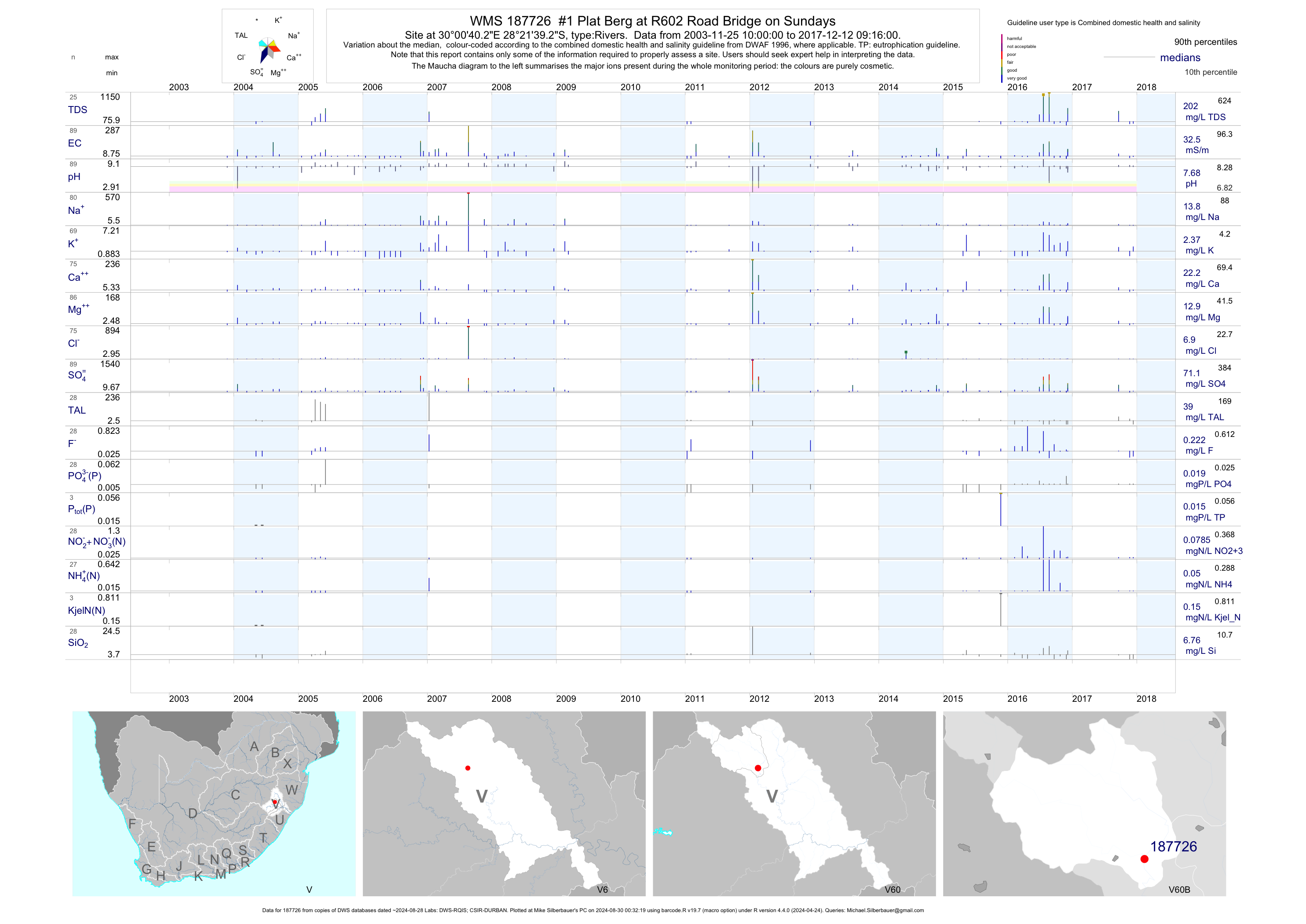
| V60 187726 | plot | data | #1 Plat Berg at R602 Road Bridge on Sundays | Rivers | 100 | 2003-11-25 | 2017-12-12 | 32 | 187726 | -28.36092 | 30.01117 |
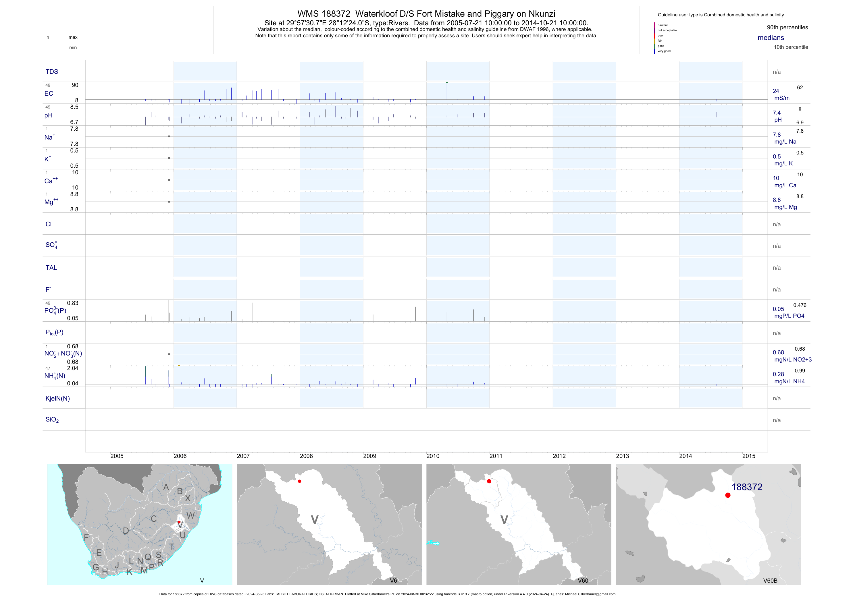
| V60 188372 | plot | data | Waterkloof D/S Fort Mistake and Piggary on Nkunzi | Rivers | 65 | 2005-07-21 | 2014-10-21 | 24 | 188372 | -28.20667 | 29.95856 |
| V60 188772 | plot | data | Quaggas Kirk upstream of Piggery on Nkunzi | Rivers | 67 | 2005-07-21 | 2014-10-21 | 22 | 188772 | -28.17944 | 29.95636 |
| V60 188773 | plot | data | Gartmore at N11 Bridge on Nkunzi | Rivers | 66 | 2005-07-21 | 2014-10-21 | 25 | 188773 | -28.23511 | 29.96706 |
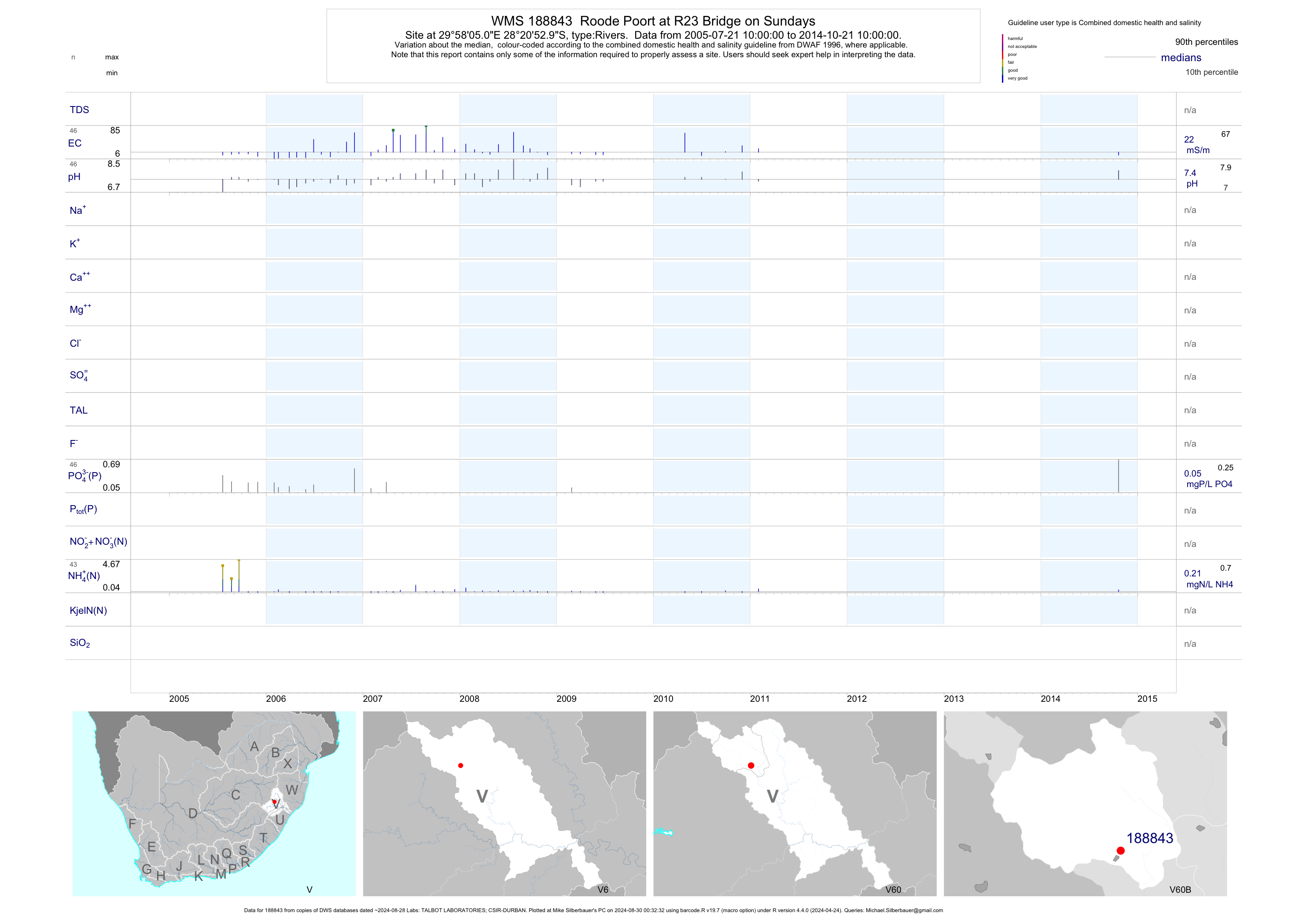
| V60 188843 | plot | data | Roode Poort at R23 Bridge on Sundays | Rivers | 62 | 2005-07-21 | 2014-10-21 | 22 | 188843 | -28.34806 | 29.96806 |
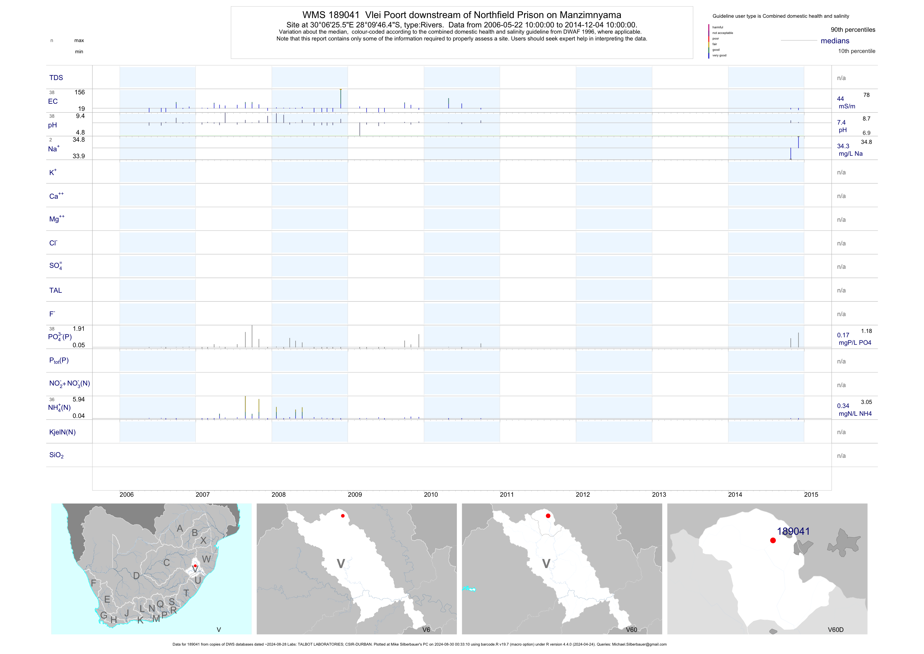
| V60 189041 | plot | data | Vlei Poort downstream of Northfield Prison on Manzimnyama | Rivers | 44 | 2006-05-22 | 2014-12-04 | 44 | 189041 | -28.16289 | 30.10708 |
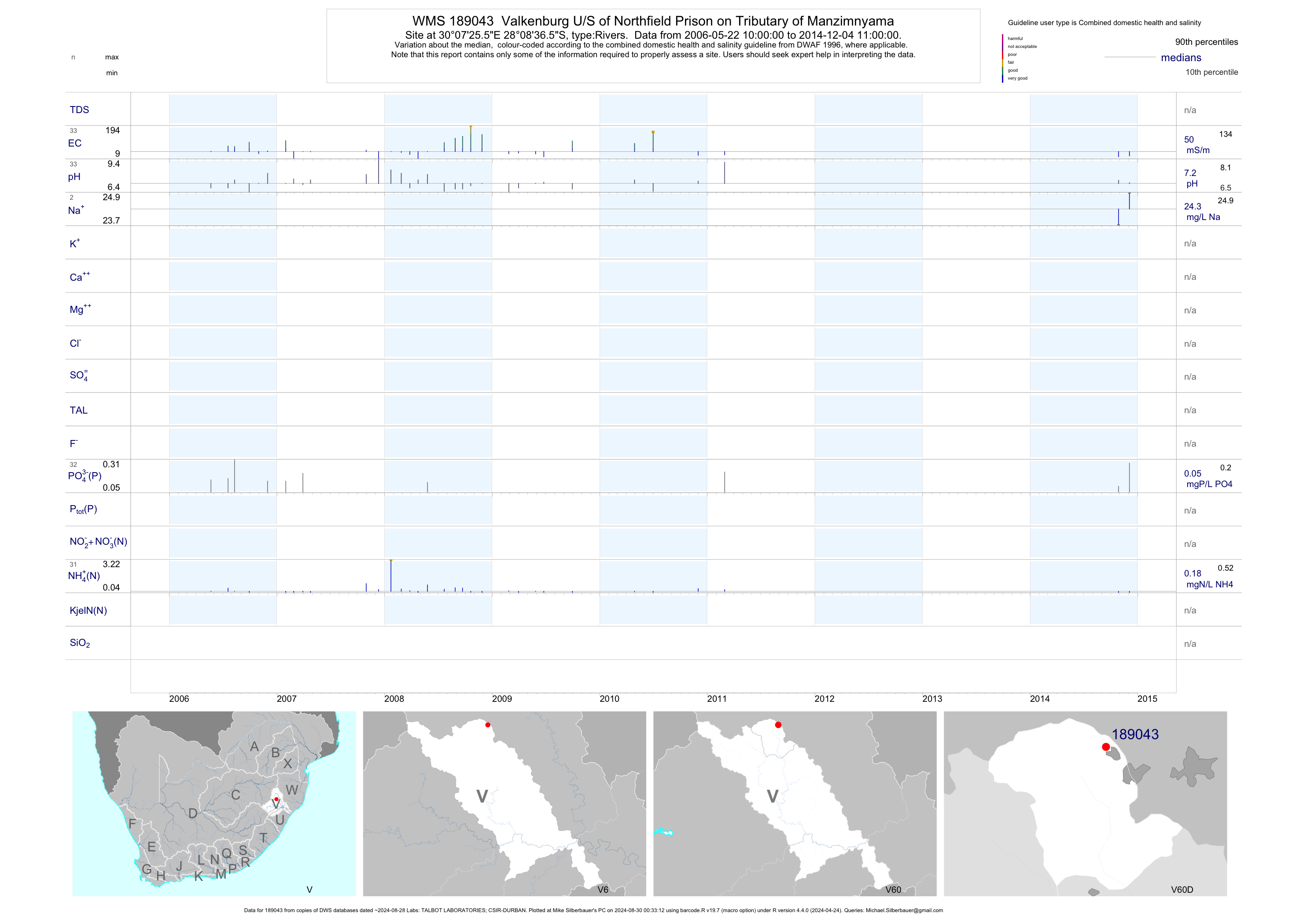
| V60 189043 | plot | data | Valkenburg U/S of Northfield Prison on Tributary of Manzimnyama | Rivers | 39 | 2006-05-22 | 2014-12-04 | 50 | 189043 | -28.14350 | 30.12378 |
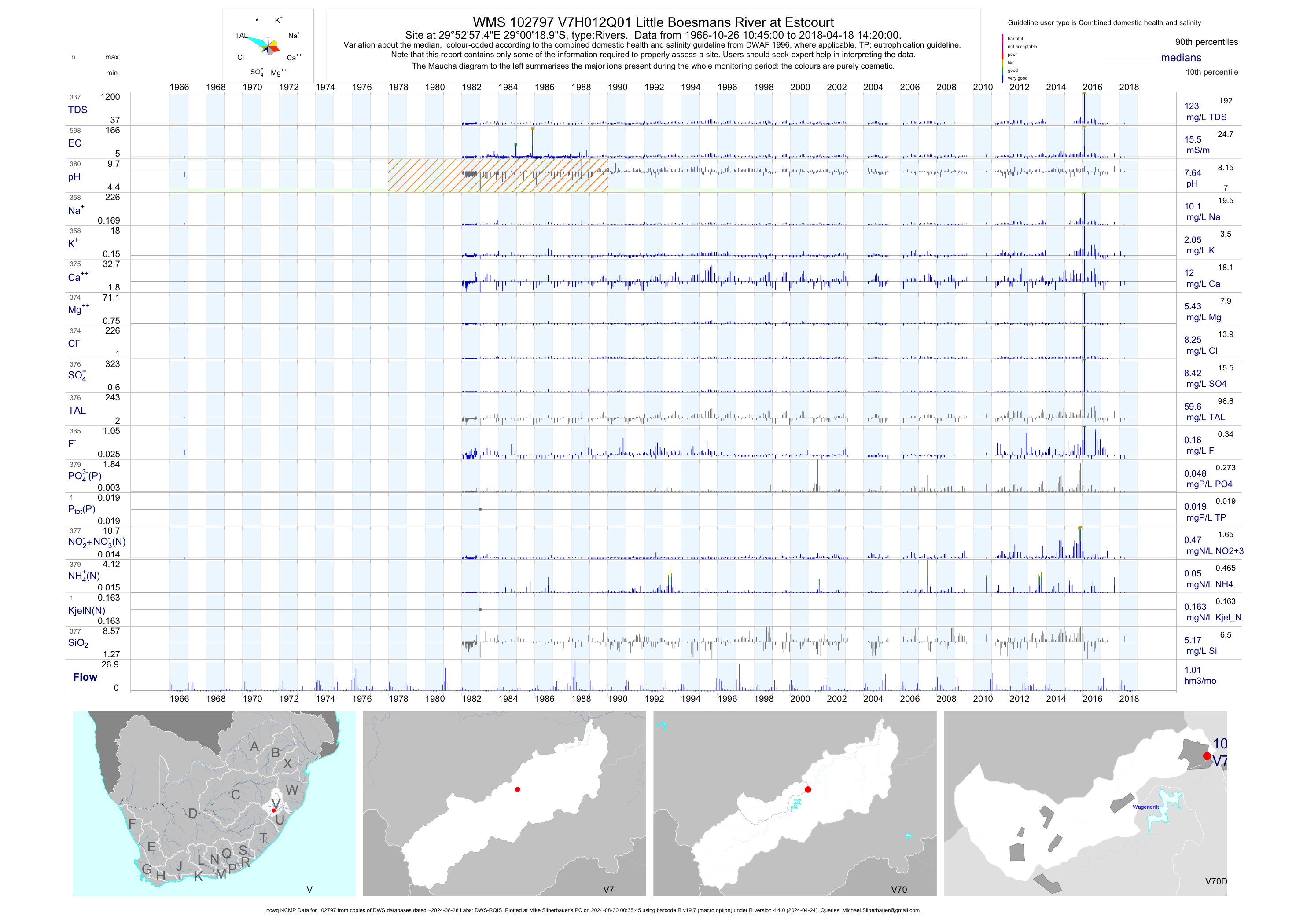
| V70 102797 | plot | data | Little Boesmans River at Estcourt (ncwq NCMP) | Rivers | 599 | 1966-10-26 | 2018-04-18 | 15 | V7H012 | -29.00525 | 29.88263 |
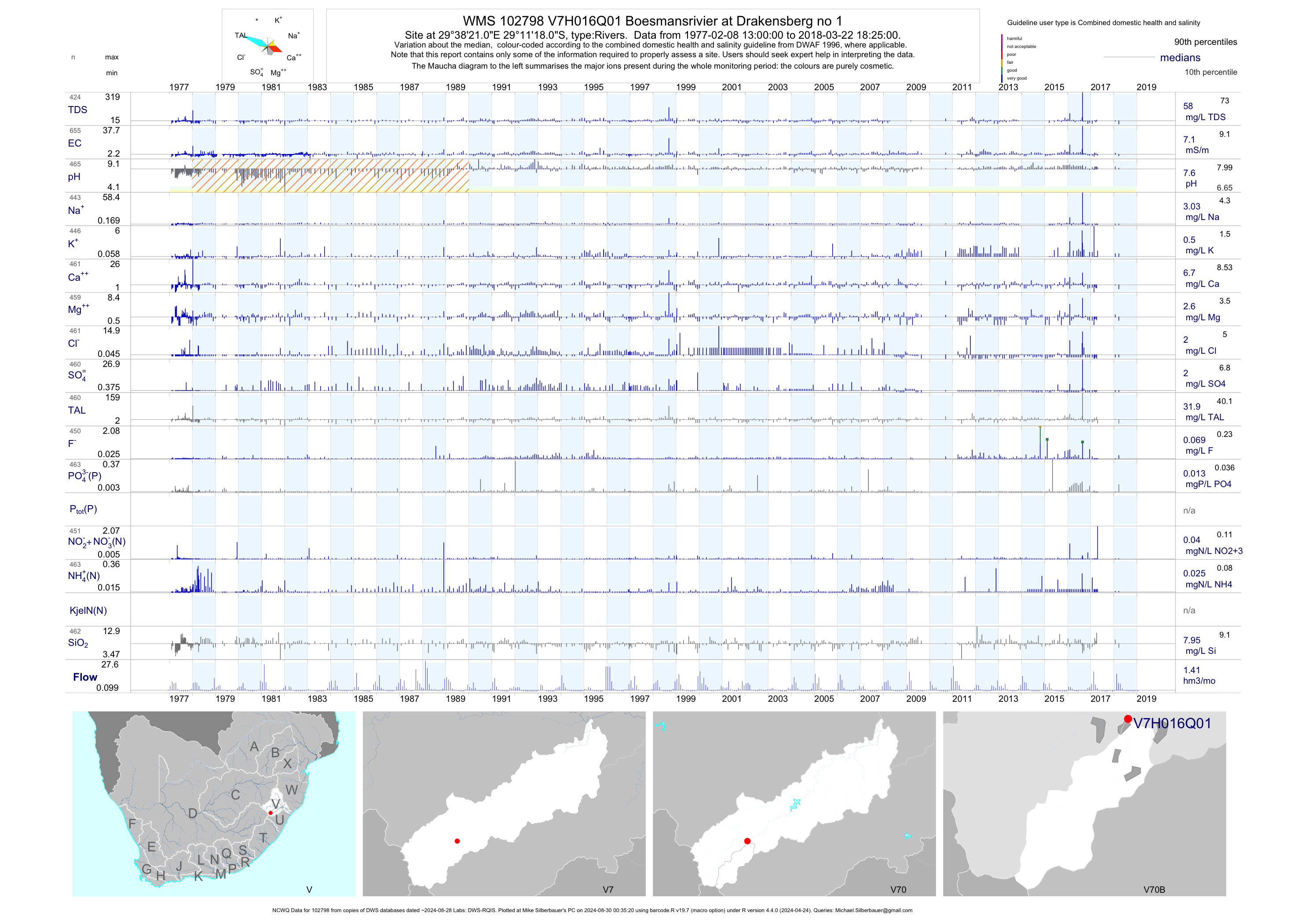
| V70 102798 | plot | data | Boesmansrivier at Drakensberg no 1 (NCWQ) | Rivers | 656 | 1977-02-08 | 2018-03-22 | 7 | V7H016 | -29.18833 | 29.63917 |
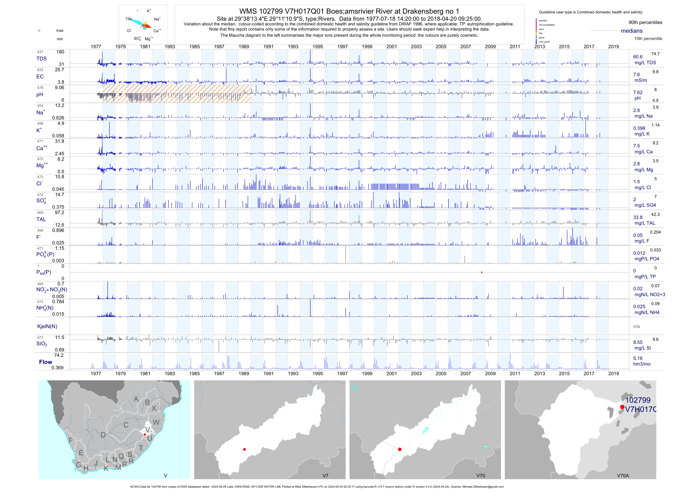
| V70 102799 | plot | data | Boes;amsrivier River at Drakensberg no 1 (NCWQ) | Rivers | 634 | 1977-07-18 | 2018-04-20 | 8 | V7H017 | -29.18638 | 29.63708 |
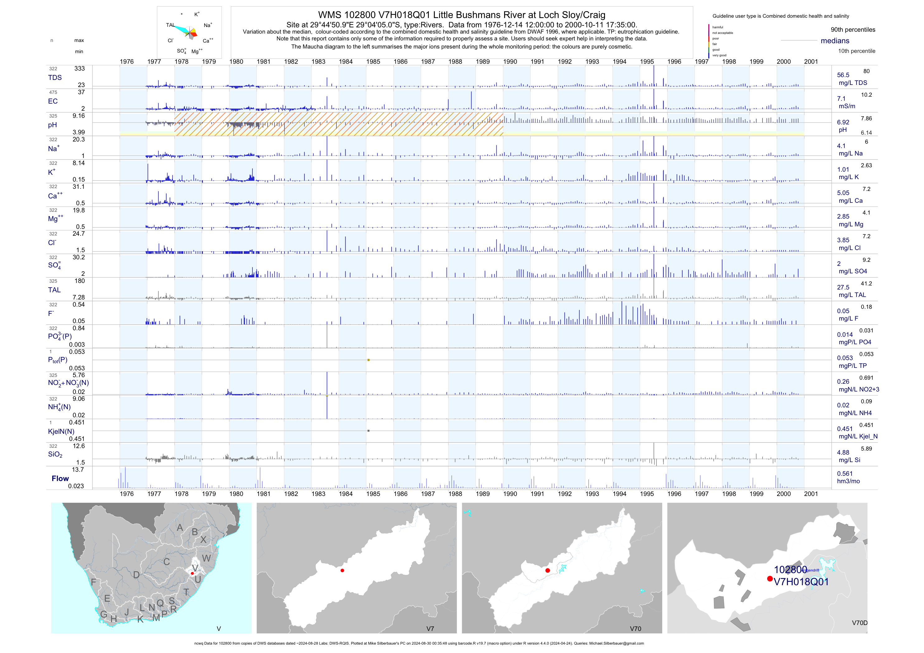
| V70 102800 | plot | data | Little Bushmans River at Loch Sloy/Craig (ncwq) | Rivers | 475 | 1976-12-14 | 2000-10-11 | 7 | V7H018 | -29.06806 | 29.74750 |
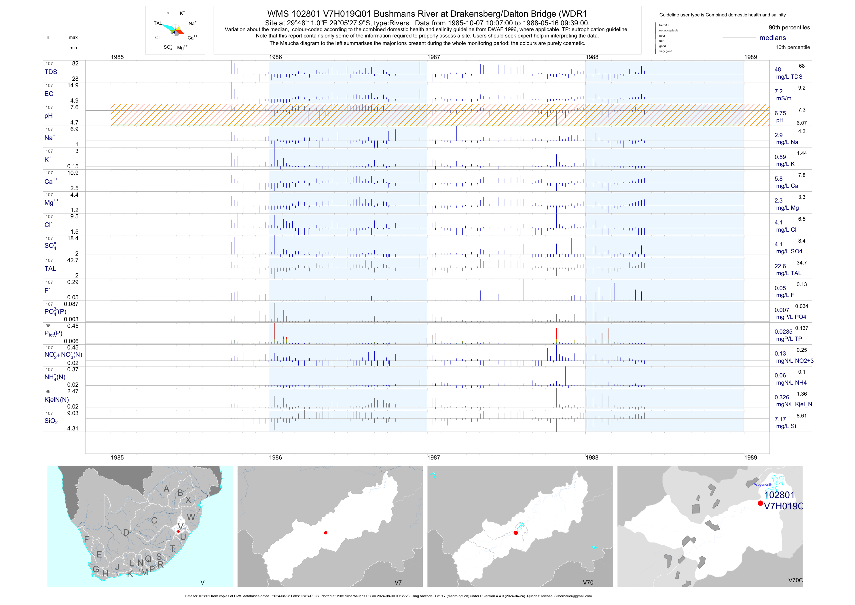
| V70 102801 | plot | data | Bushmans River at Drakensberg/Dalton Bridge (WDR1 | Rivers | 107 | 1985-10-07 | 1988-05-16 | 7 | V7H019 | -29.09111 | 29.80306 |
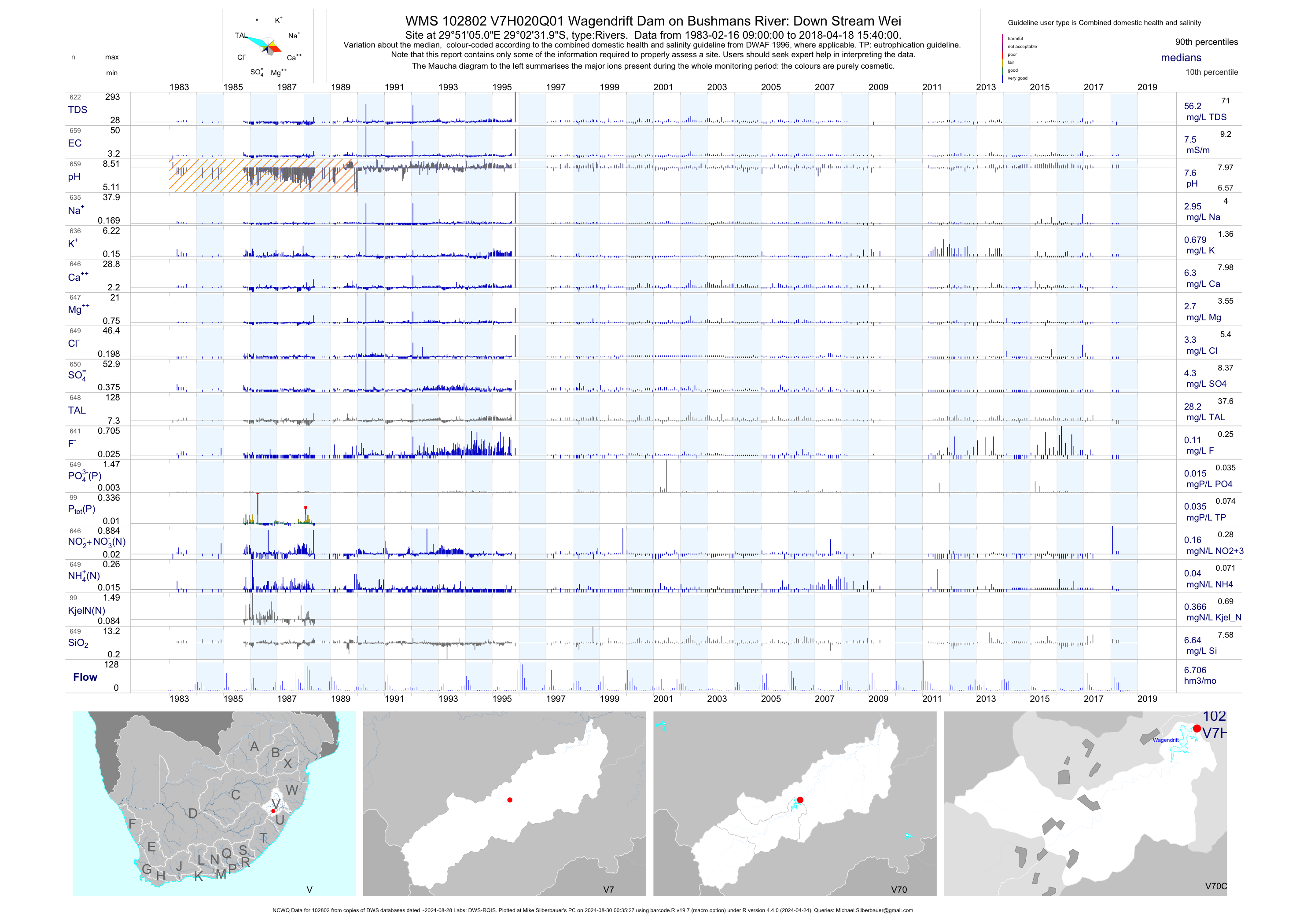
| V70 102802 | plot | data | Wagendrift Dam on Bushmans River: Down Stream Wei (NCWQ) | Rivers | 660 | 1983-02-16 | 2018-04-18 | 8 | V7H020 | -29.04222 | 29.85139 |
| V70 188807 | plot | data | Borough of Estcourt D/S Estcourt STW Discharge on Boesmansrivier | Rivers | 99 | 2005-02-17 | 2016-10-27 | 24 | 188807 | -29.01217 | 29.90783 |
| V70 188808 | plot | data | Borough of Estcourt U/S Estcourt STW Discharge on Boesmansrivier | Rivers | 99 | 2005-02-17 | 2016-10-27 | 7 | 188808 | -29.01556 | 29.88464 |
| V70 189737 | plot | data | Craig 15988 - upstream of Wembezi WWTW on Klein-Boesmansrivier | Rivers | 1 | 2015-08-12 | 2015-08-12 | 23 | 189737 | -29.03456 | 29.77808 |
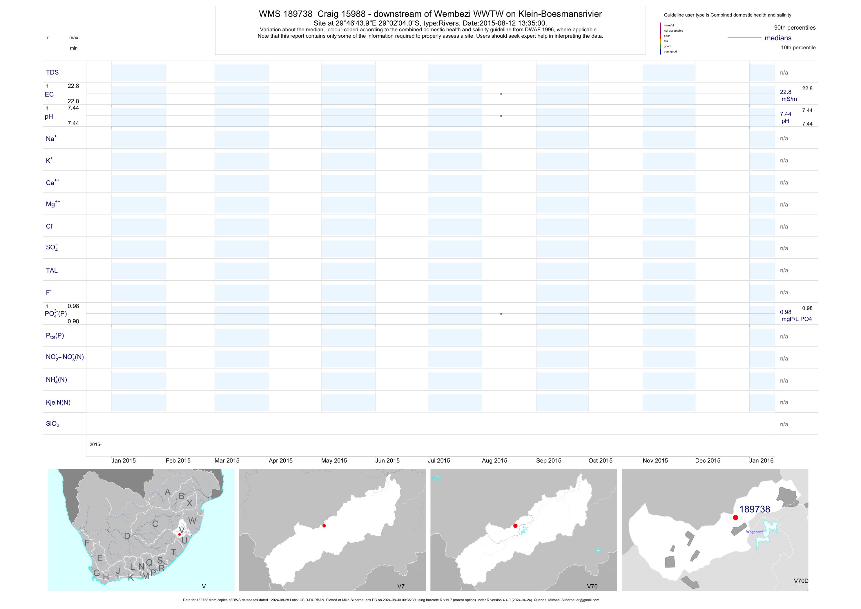
| V70 189738 | plot | data | Craig 15988 - downstream of Wembezi WWTW on Klein-Boesmansrivier | Rivers | 1 | 2015-08-12 | 2015-08-12 | 23 | 189738 | -29.03444 | 29.77889 |
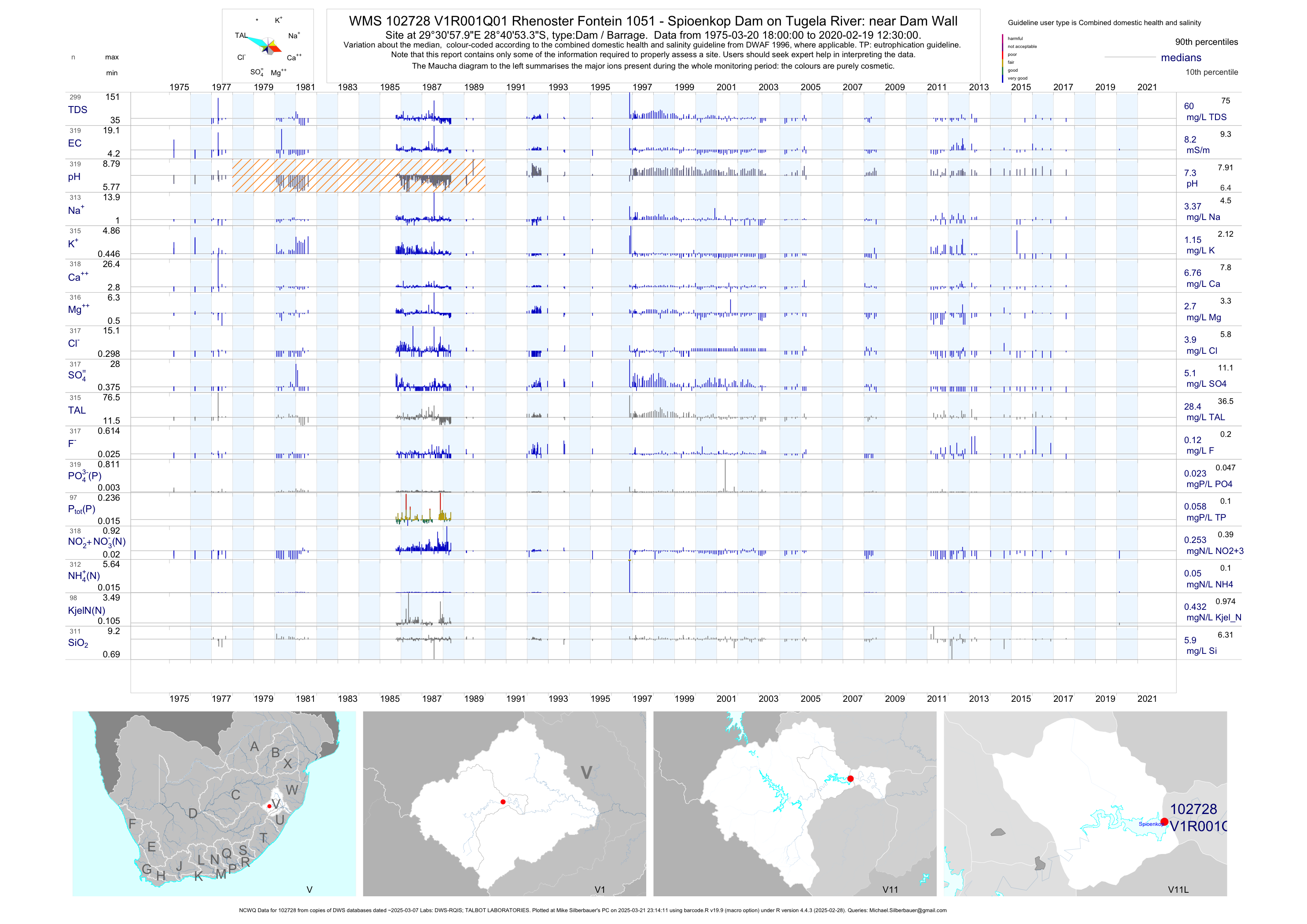
| V11 102728 | plot | data | Rhenoster Fontein 1051 - Spioenkop Dam on Tugela River: near Dam Wall (NCWQ) Q01 | Dam / Barrage | 320 | 1975-03-20 | 2017-08-08 | 8 | V1R001 | -28.68150 | 29.51610 |
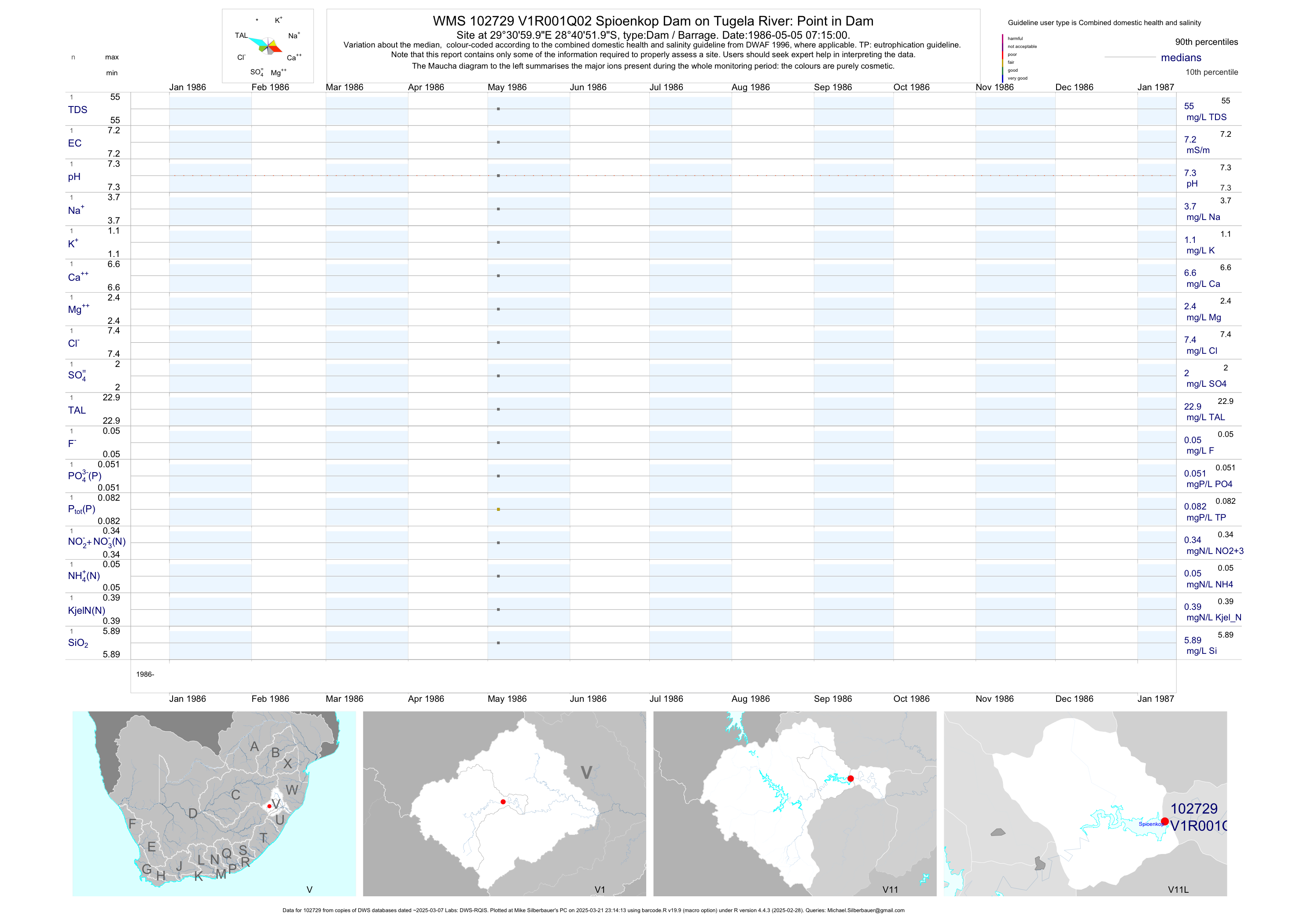
| V11 102729 | plot | data | Spioenkop Dam on Tugela River: Point in Dam Q02 | Dam / Barrage | 1 | 1986-05-05 | 1986-05-05 | 7 | V1R001 | -28.68111 | 29.51667 |
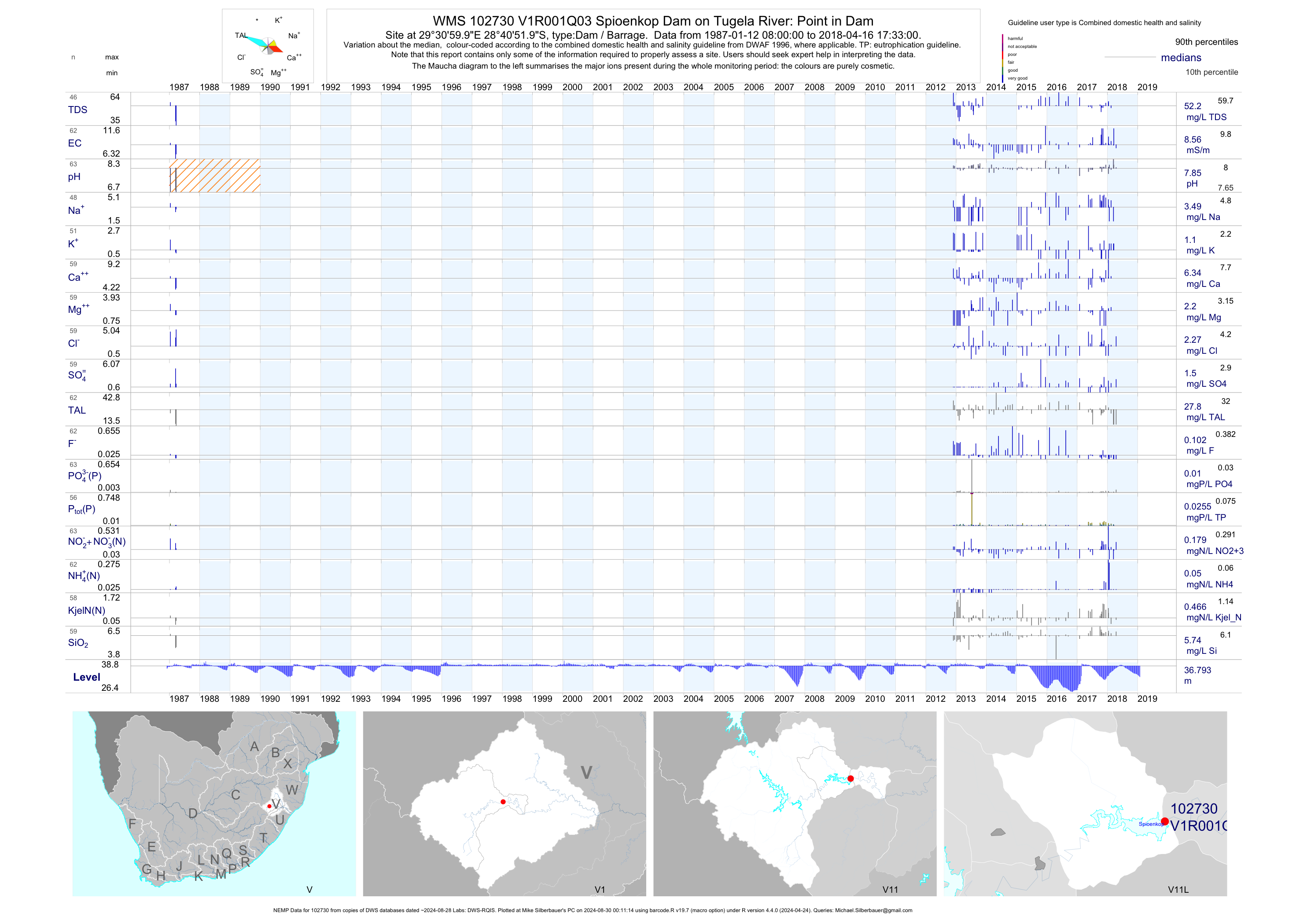
| V11 102730 | plot | data | Spioenkop Dam on Tugela River: Point in Dam (NEMP) Q03 | Dam / Barrage | 889 | 1987-01-12 | 2018-08-21 | 9 | V1R001 | -28.68111 | 29.51667 |
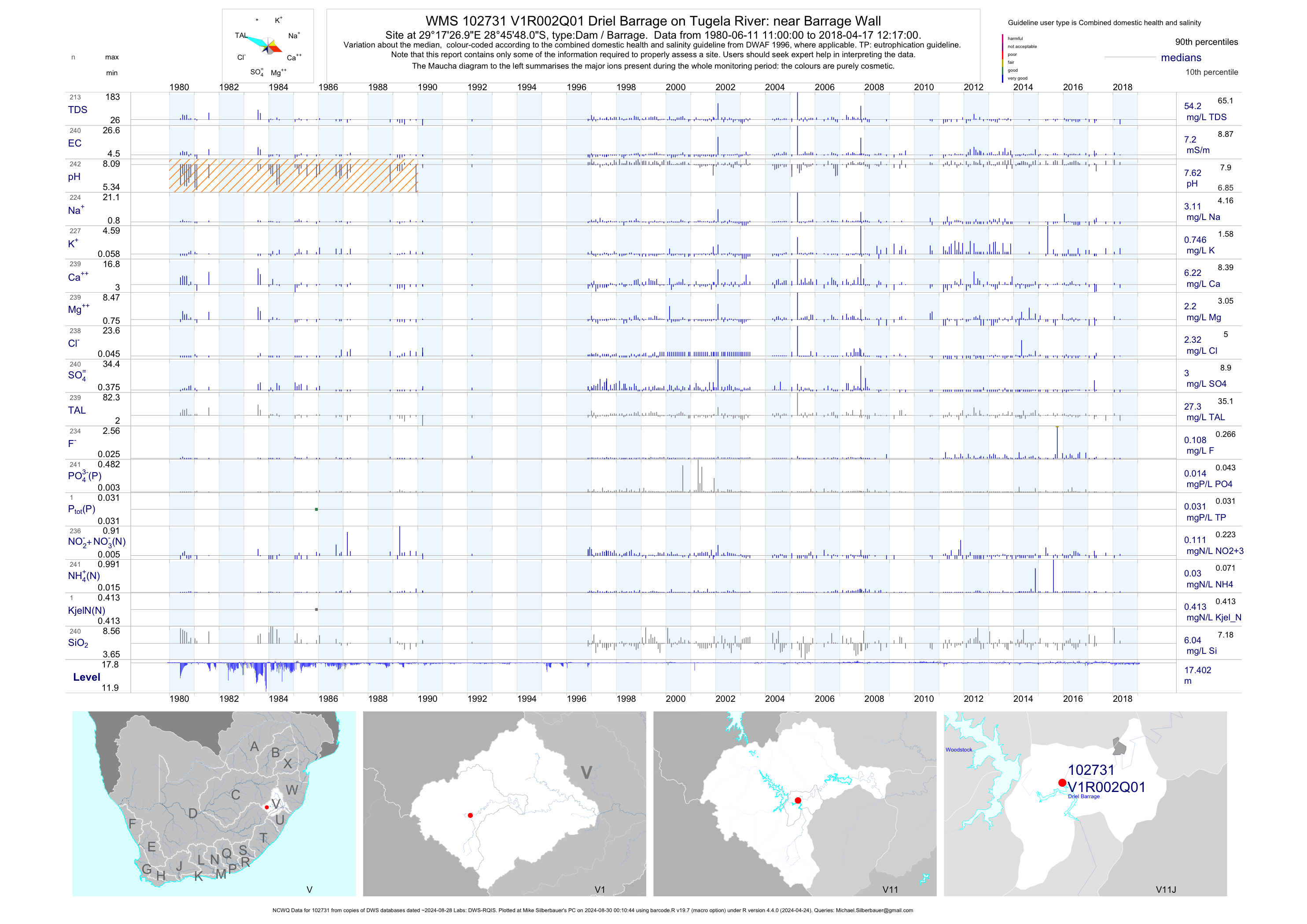
| V11 102731 | plot | data | Driel Barrage on Tugela River: near Barrage Wall (NCWQ) Q01 | Dam / Barrage | 846 | 1980-06-11 | 2018-04-17 | 7 | V1R002 | -28.76333 | 29.29083 |
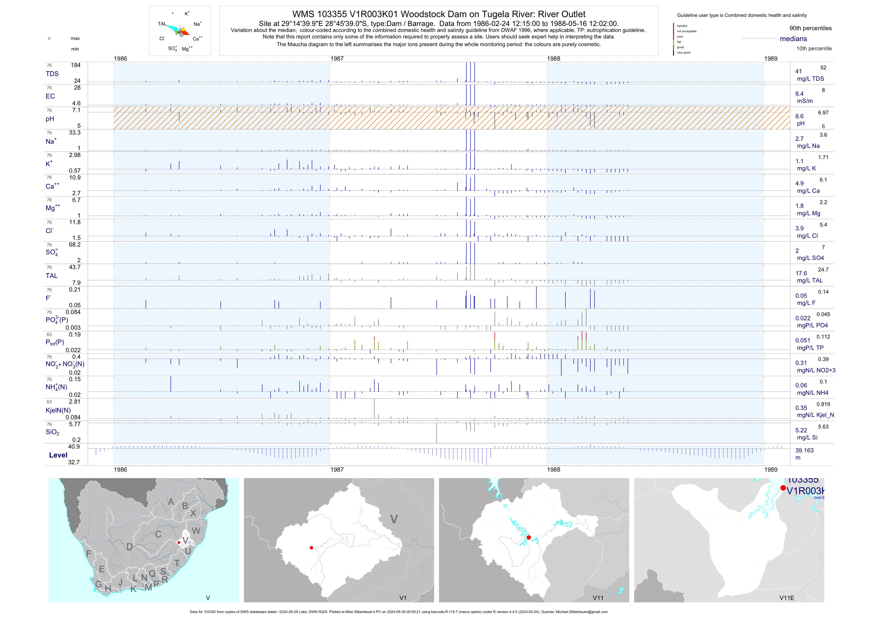
| V11 103355 | plot | data | Woodstock Dam on Tugela River: River Outlet K01 | Dam / Barrage | 76 | 1986-02-24 | 1988-05-16 | 6 | V1R003 | -28.76083 | 29.24444 |
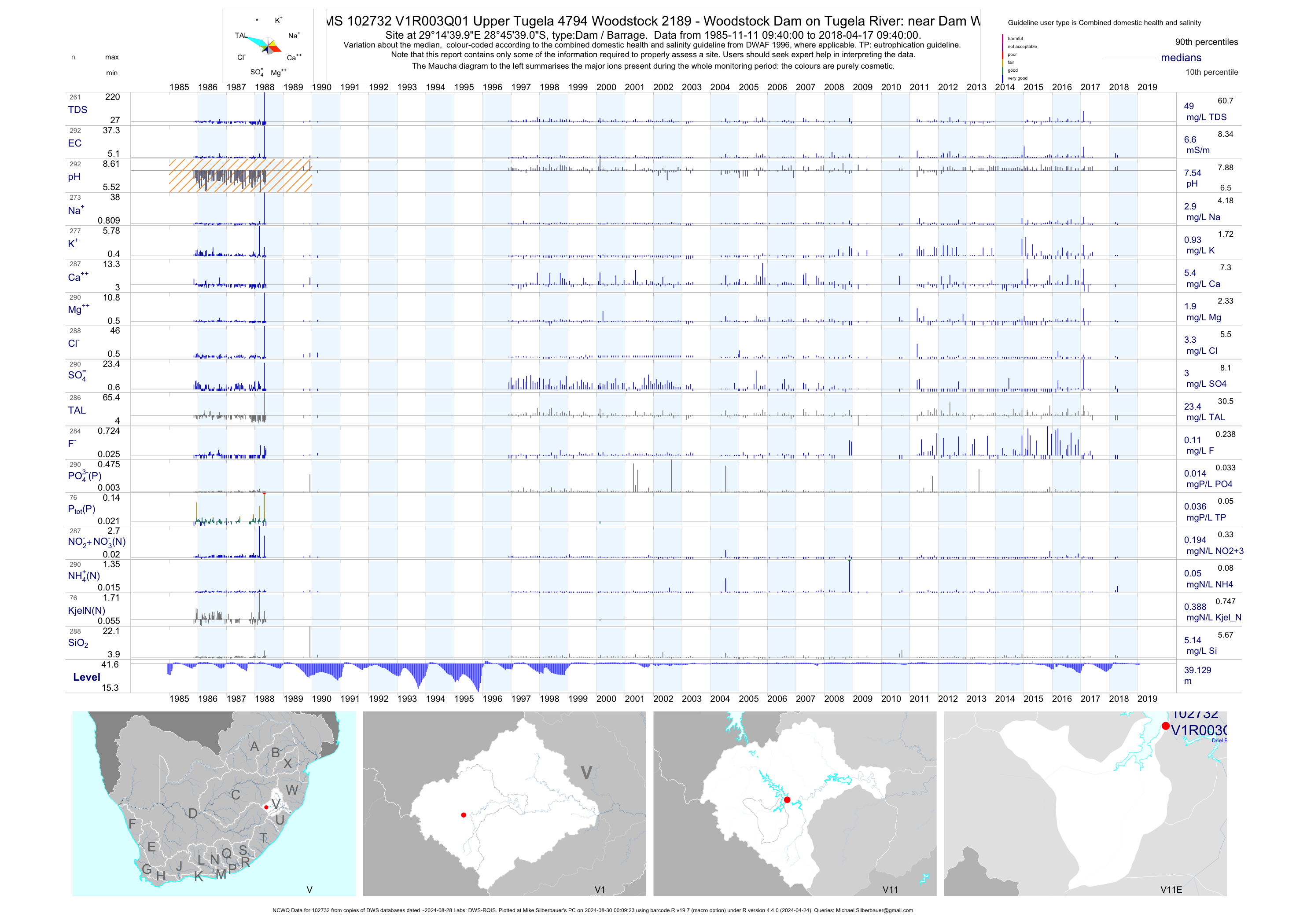
| V11 102732 | plot | data | Upper Tugela 4794 Woodstock 2189 - Woodstock Dam on Tugela River: near Dam Wall (NCWQ) Q01 | Dam / Barrage | 292 | 1985-11-11 | 2018-04-17 | 7 | V1R003 | -28.76083 | 29.24444 |
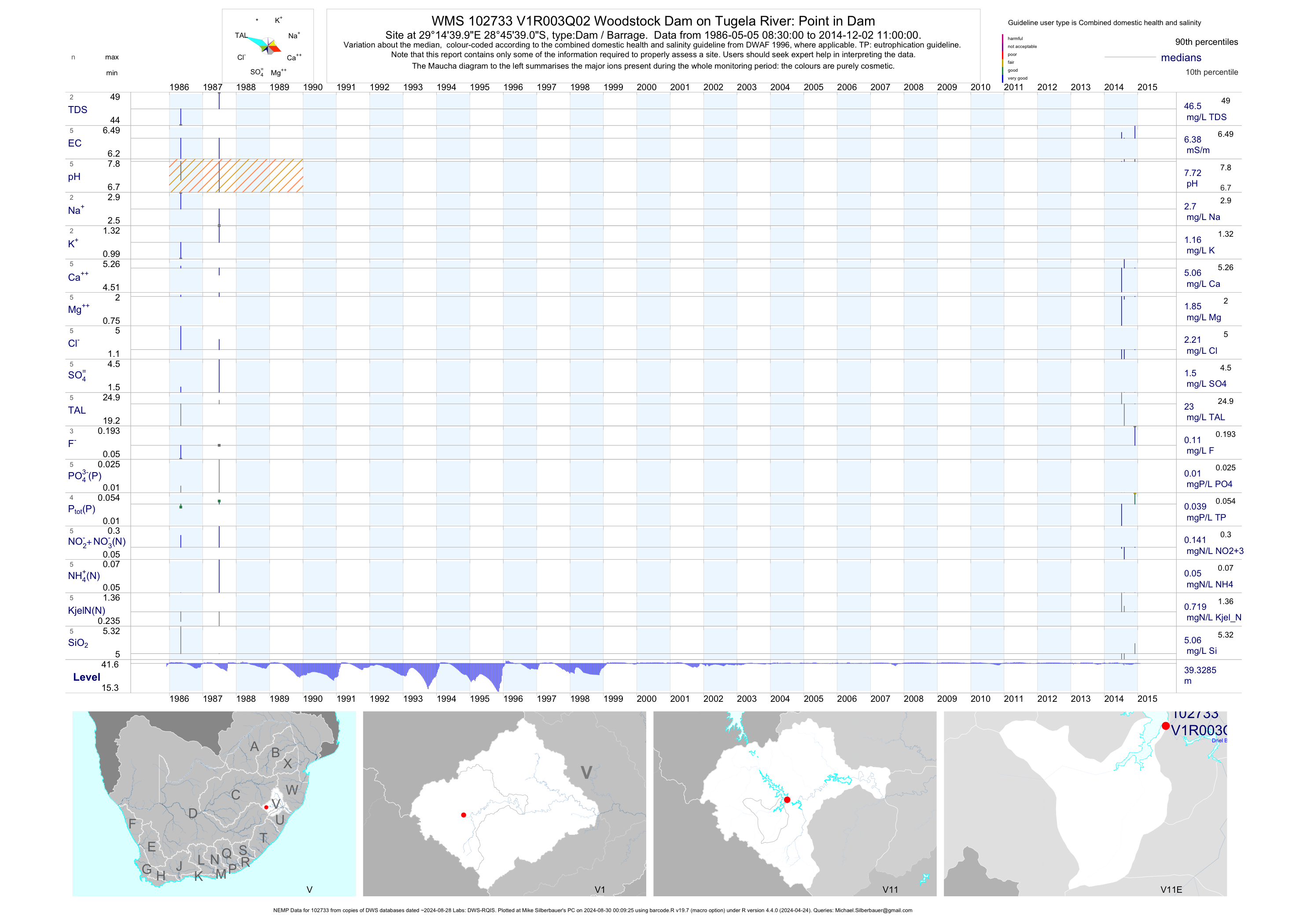
| V11 102733 | plot | data | Woodstock Dam on Tugela River: Point in Dam (NEMP) Q02 | Dam / Barrage | 732 | 1986-05-05 | 2014-12-02 | 6 | V1R003 | -28.76083 | 29.24444 |
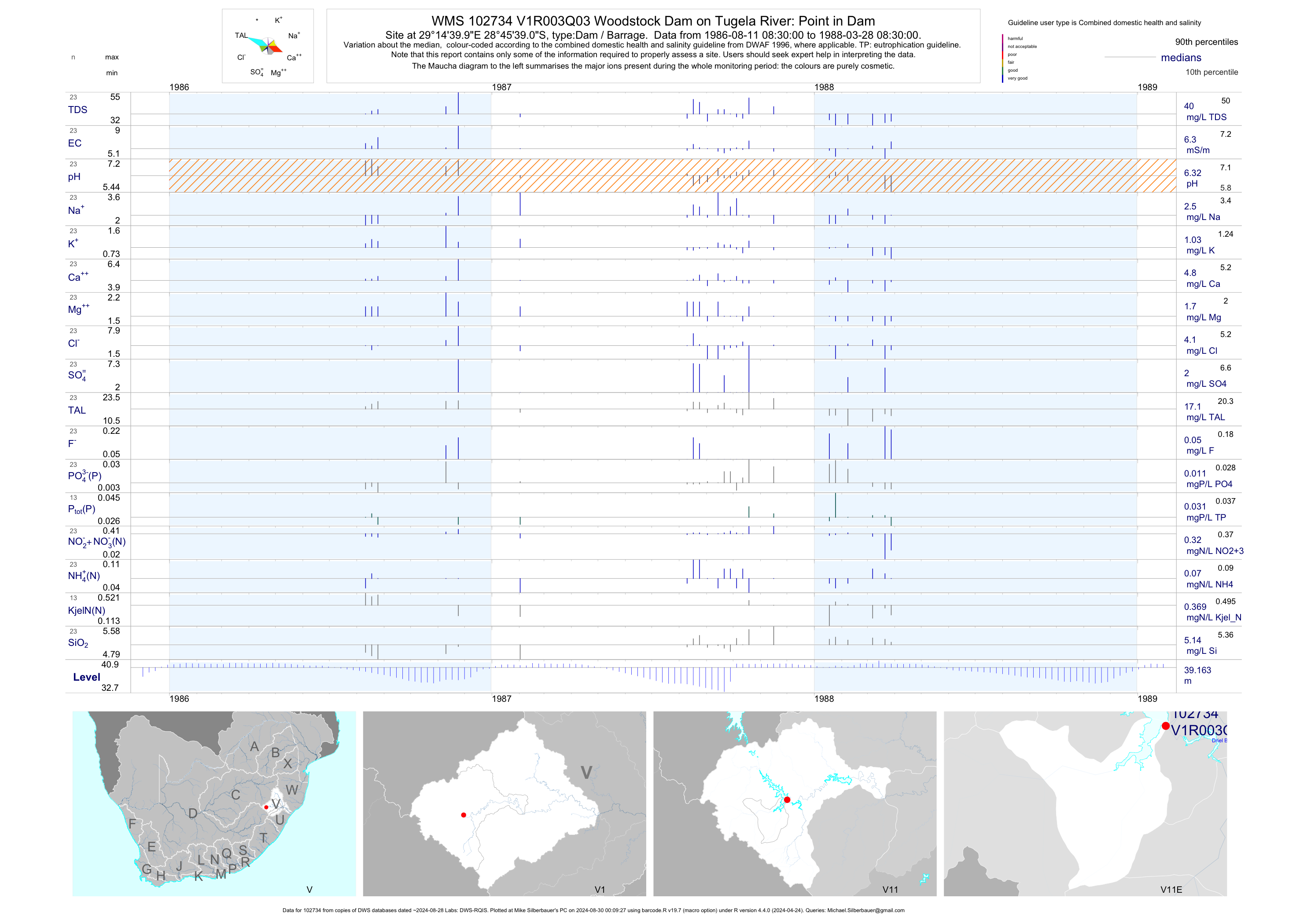
| V11 102734 | plot | data | Woodstock Dam on Tugela River: Point in Dam Q03 | Dam / Barrage | 23 | 1986-08-11 | 1988-03-28 | 6 | V1R003 | -28.76083 | 29.24444 |
| V11 187330 | n/a | n/a | Kilburn on Kilburn Dam Q01 | Dam / Barrage | 1 | 2000-02-14 | 2000-02-14 | n/a | V1R004 | -28.59028 | 29.10417 |
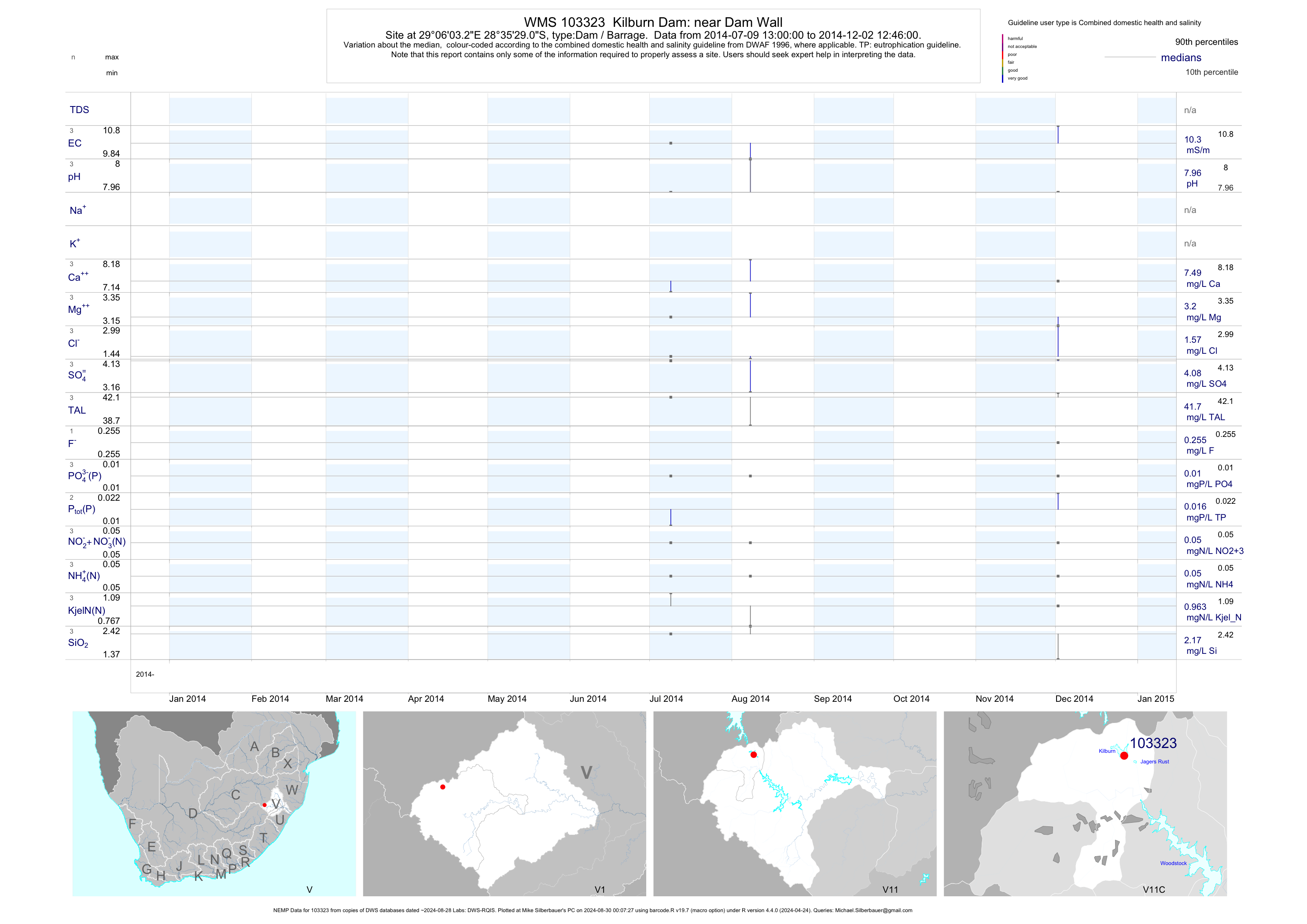
| V11 103323 | plot | data | Kilburn Dam: near Dam Wall (NEMP) | Dam / Barrage | 601 | 2003-01-04 | 2014-12-02 | 10 | 103323 | -28.59140 | 29.10090 |
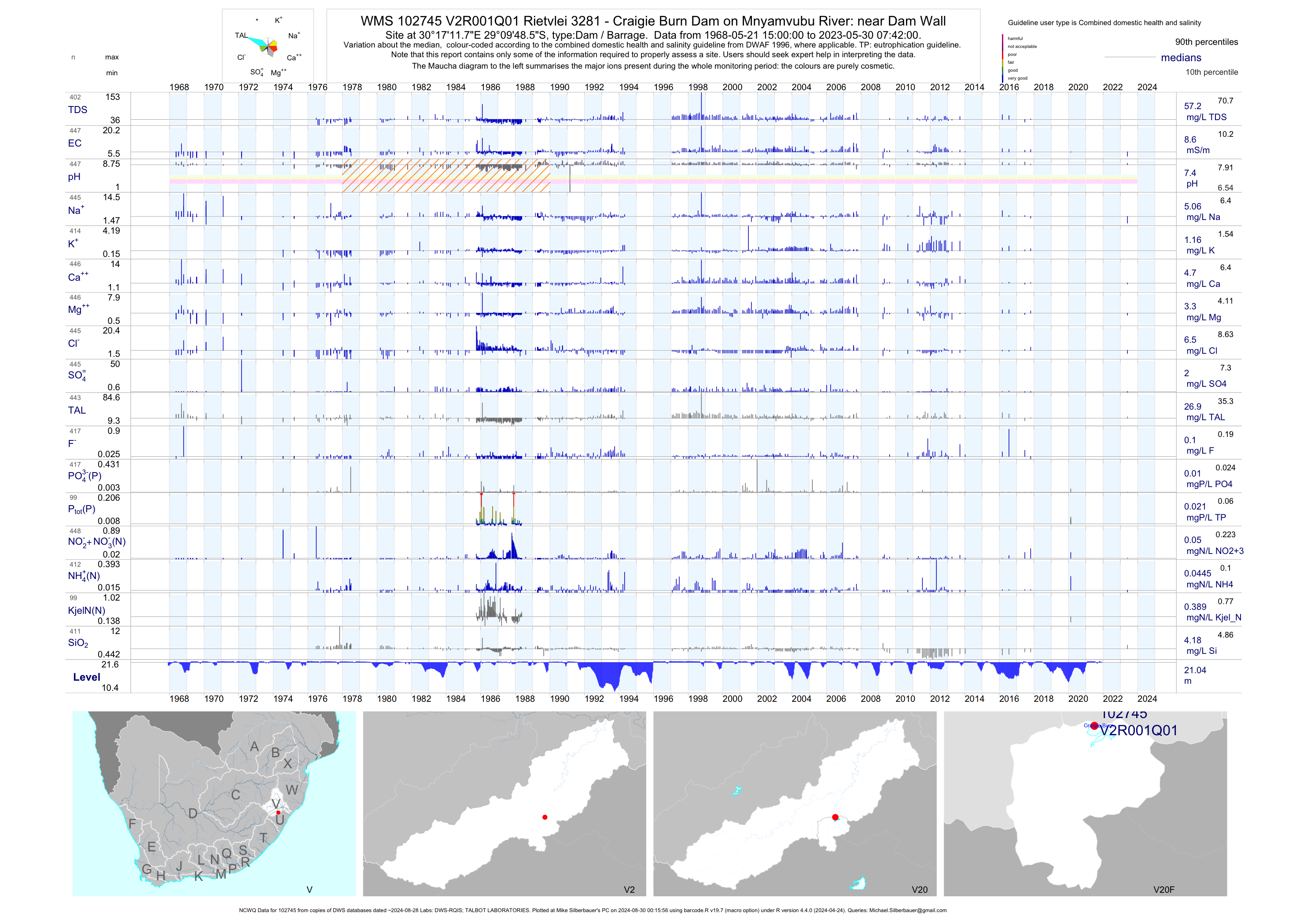
| V20 102745 | plot | data | Rietvlei 3281 - Craigie Burn Dam on Mnyamvubu River: near Dam Wall (NCWQ) Q01 | Dam / Barrage | 447 | 1968-05-21 | 2017-10-24 | 9 | V2R001 | -29.16350 | 30.28660 |
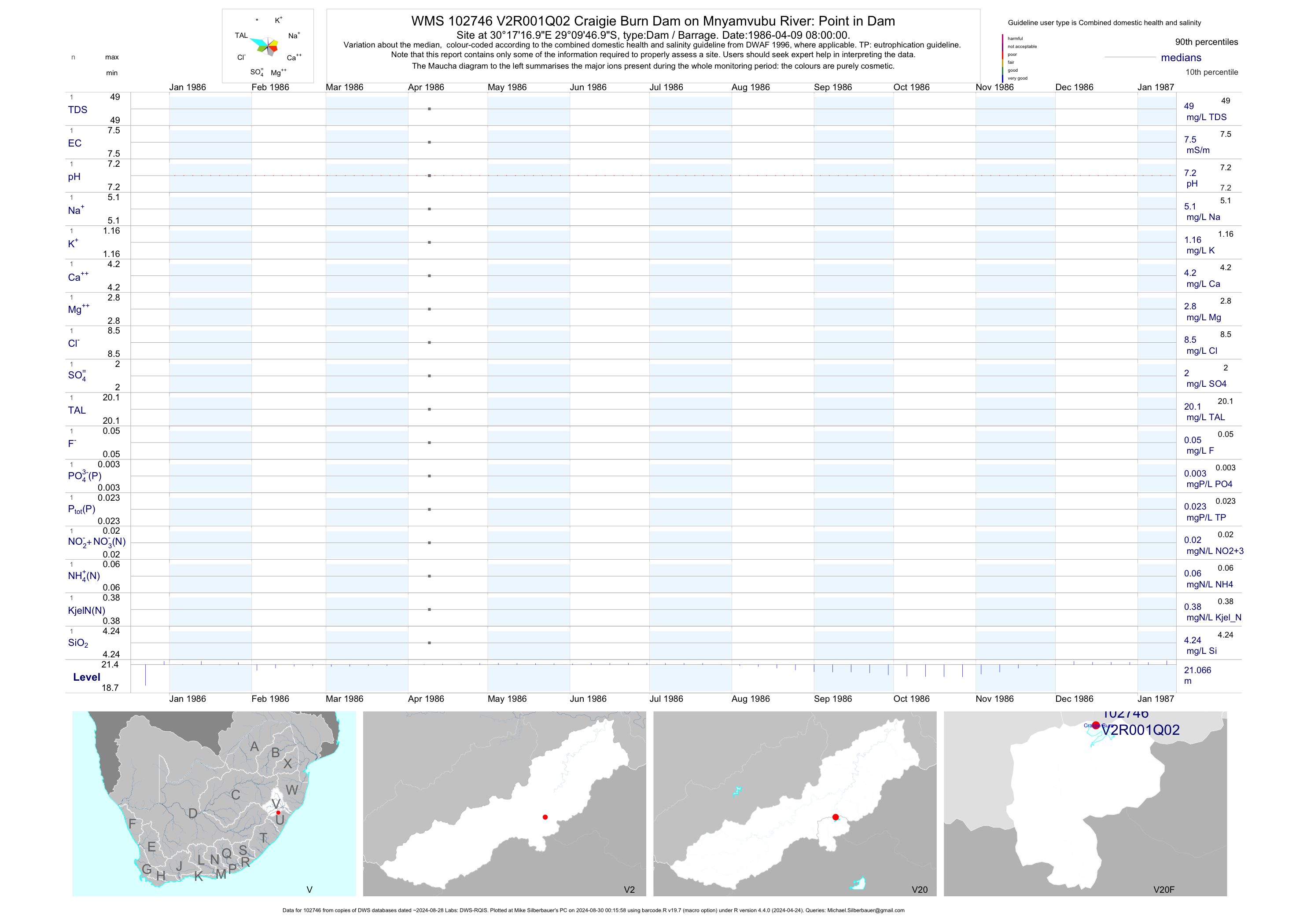
| V20 102746 | plot | data | Craigie Burn Dam on Mnyamvubu River: Point in Dam Q02 | Dam / Barrage | 1 | 1986-04-09 | 1986-04-09 | 8 | V2R001 | -29.16306 | 30.28806 |
| V20 102747 | plot | data | Graigie Burn Dam on Mnyamvubu River: Point in Dam Q03 | Dam / Barrage | 1 | 1987-04-22 | 1987-04-22 | 7 | V2R001 | -29.16306 | 30.28806 |
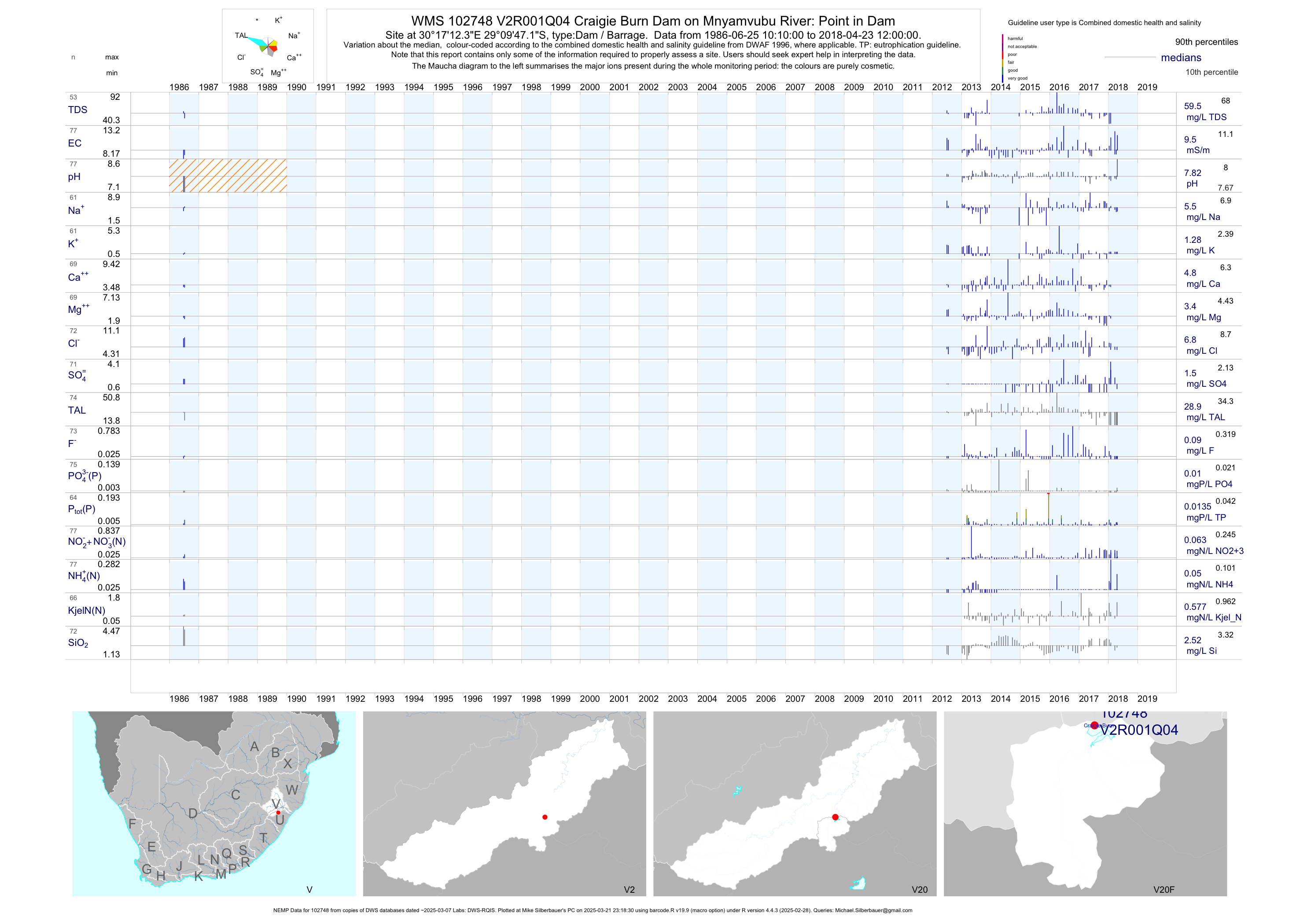
| V20 102748 | plot | data | Craigie Burn Dam on Mnyamvubu River: Point in Dam (NEMP) Q04 | Dam / Barrage | 771 | 1986-06-25 | 2018-09-04 | 10 | V2R001 | -29.16309 | 30.28678 |
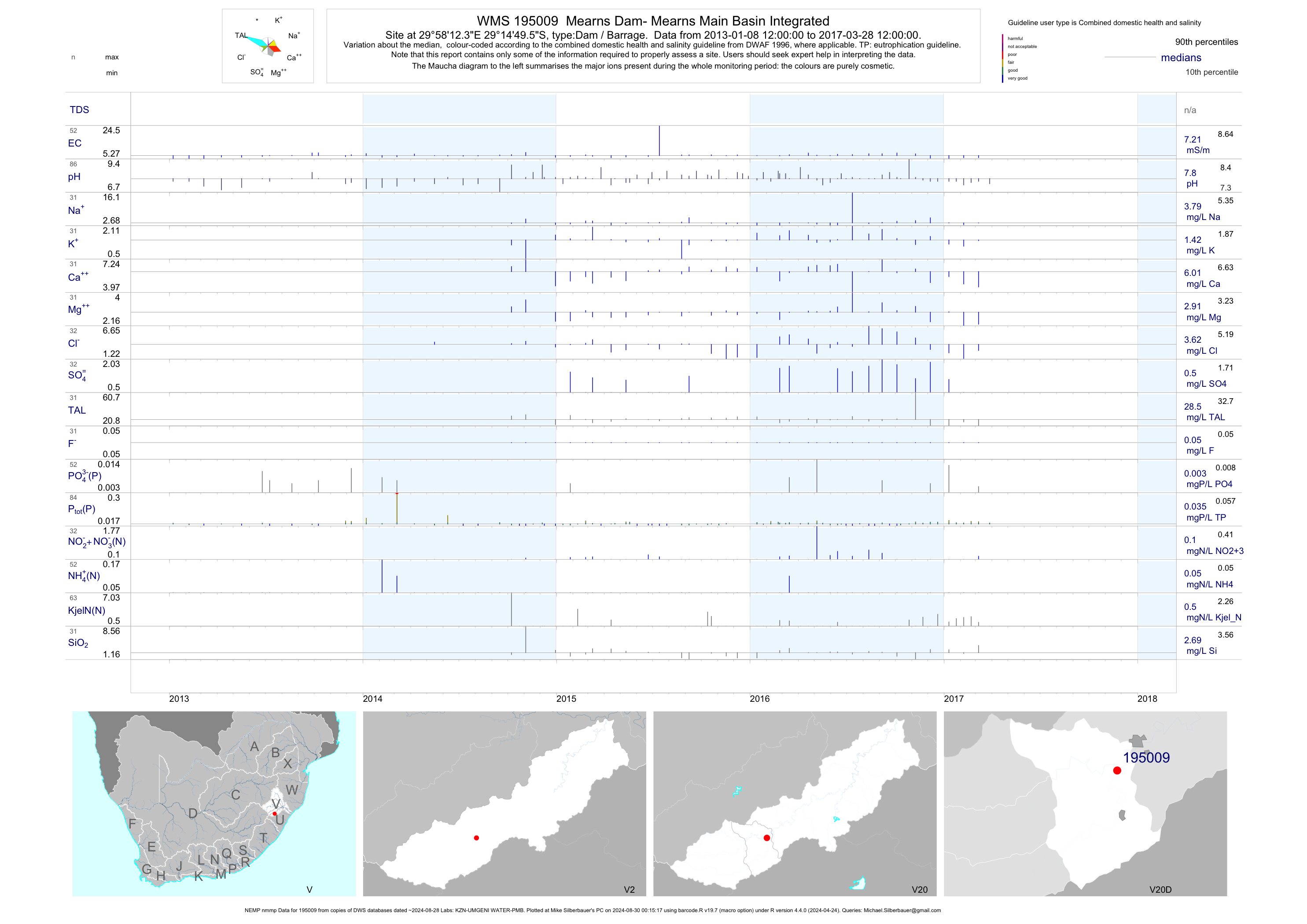
| V20 195009 | plot | data | Mearns Dam- Mearns Main Basin Integrated (NEMP nmmp) | Dam / Barrage | 554 | 2013-01-08 | 2017-03-28 | 7 | 195009 | -29.24710 | 29.97010 |
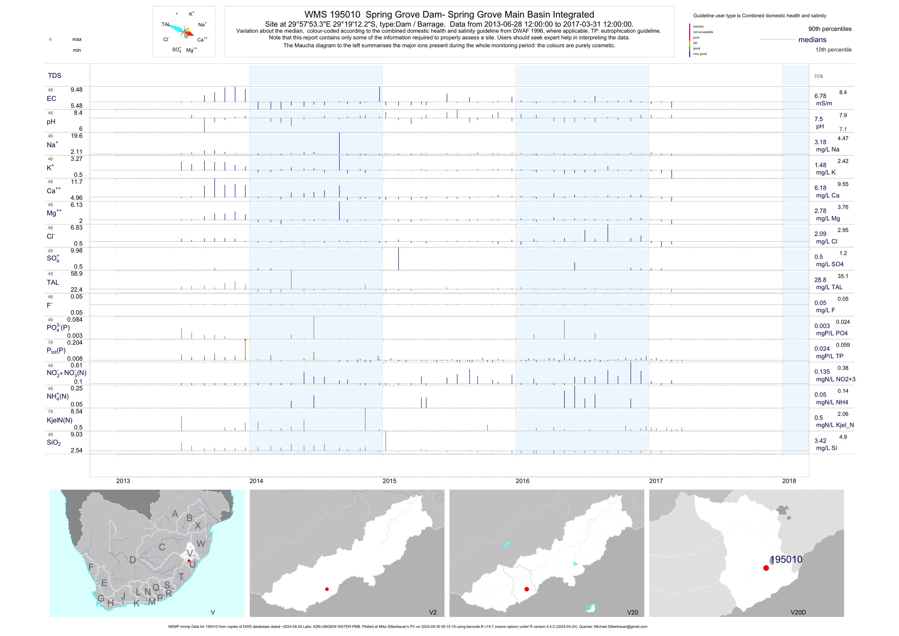
| V20 195010 | plot | data | Spring Grove Dam- Spring Grove Main Basin Integrated (NEMP nmmp) | Dam / Barrage | 581 | 2013-06-28 | 2017-03-31 | 7 | 195010 | -29.32006 | 29.96481 |
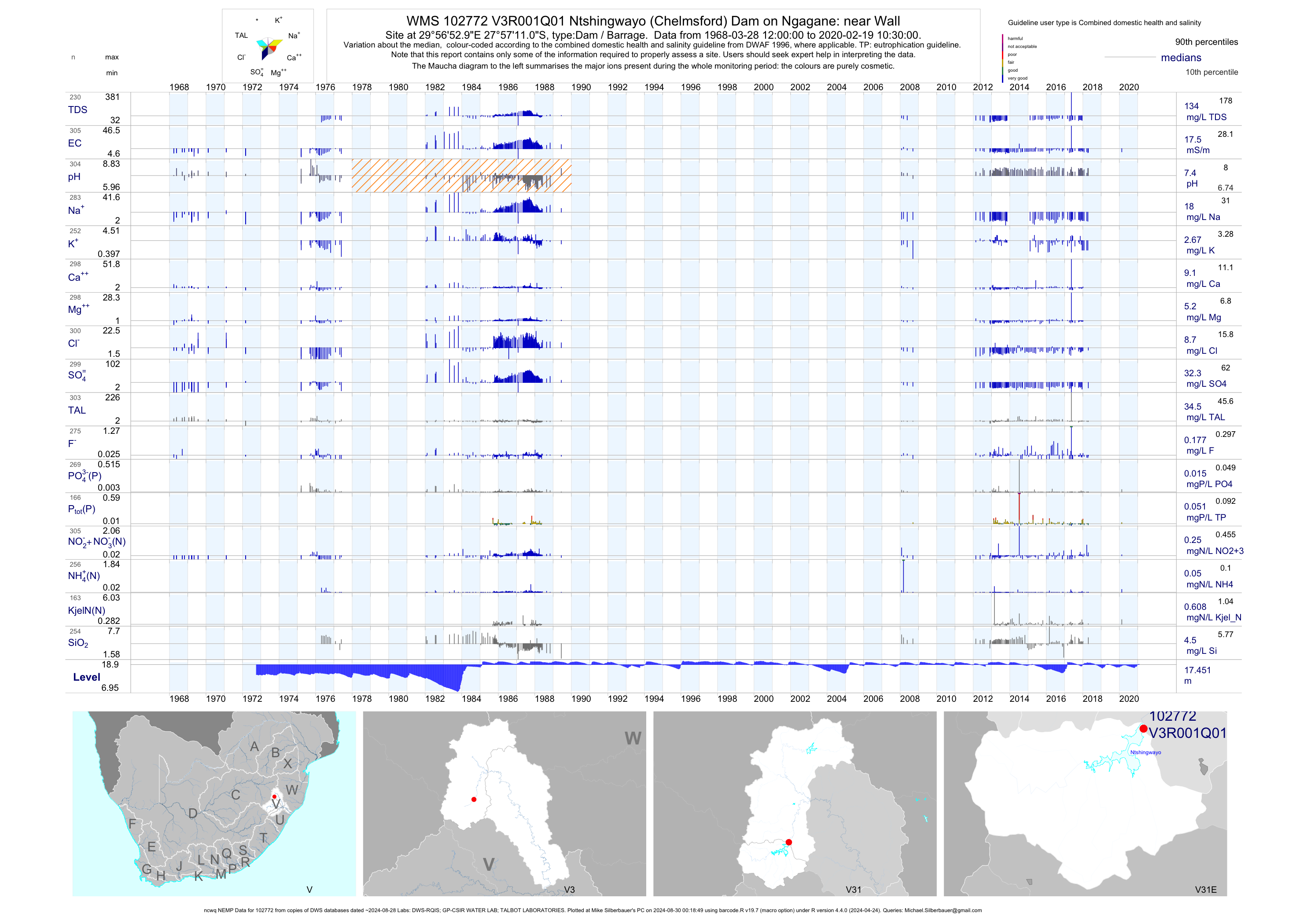
| V31 102772 | plot | data | Ntshingwayo (Chelmsford) Dam on Ngagane: near Wall (ncwq NEMP) Q01 | Dam / Barrage | 1114 | 1968-03-28 | 2018-08-22 | 18 | V3R001 | -27.95306 | 29.94806 |
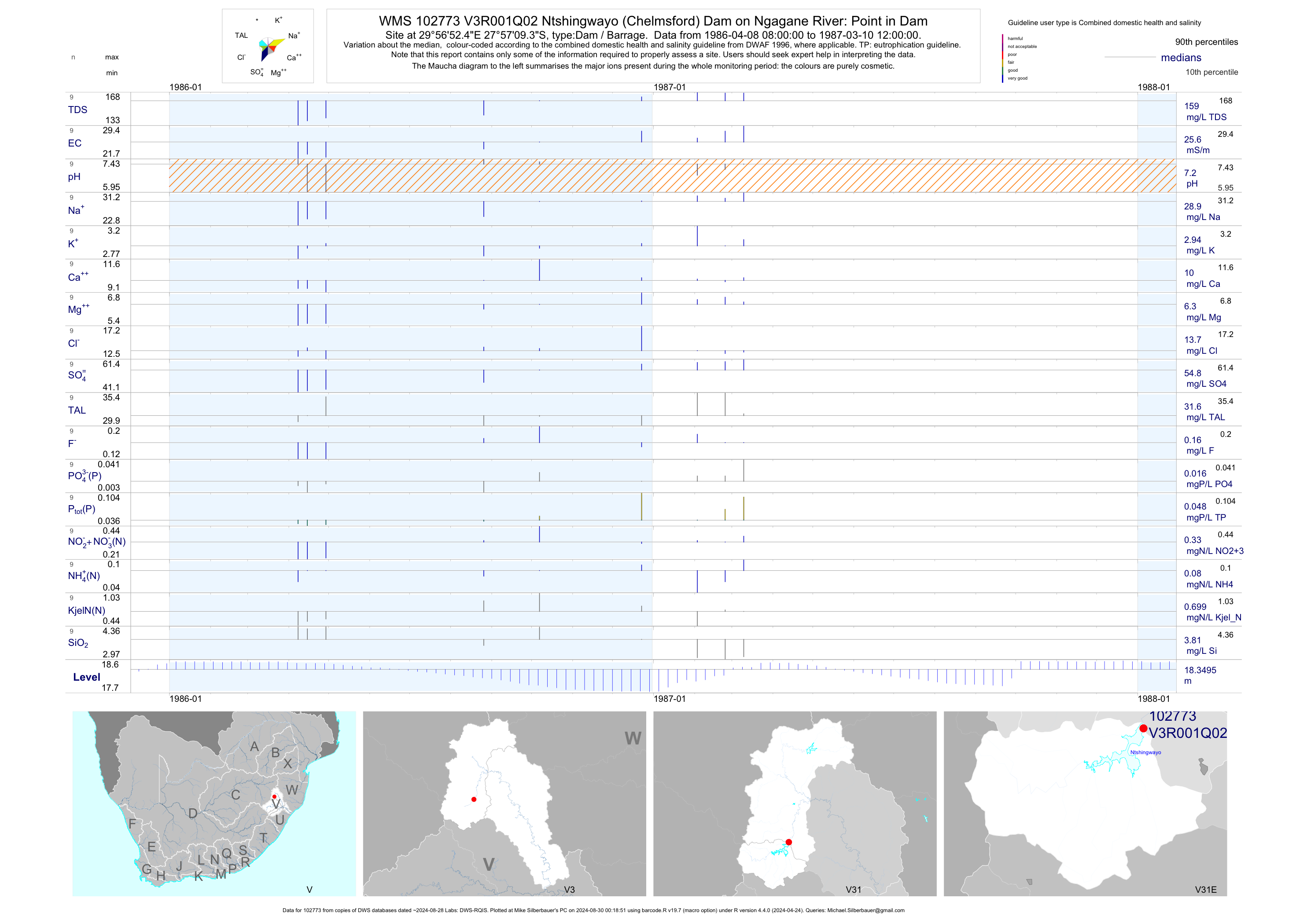
| V31 102773 | plot | data | Ntshingwayo (Chelmsford) Dam on Ngagane River: Point in Dam Q02 | Dam / Barrage | 9 | 1986-04-08 | 1987-03-10 | 26 | V3R001 | -27.95260 | 29.94790 |
| V31 102774 | plot | data | Ntshingwayo (Chelmsford) Dam on Ngagane River: Point in Dam Q03 | Dam / Barrage | 3 | 1986-05-06 | 1987-04-28 | 23 | V3R001 | -27.95280 | 29.94770 |
| V31 102775 | plot | data | Ntshingwayo (Chelmsford) Dam on Ngagane River: Point in Dam Q04 | Dam / Barrage | 3 | 1986-06-24 | 1987-05-05 | 24 | V3R001 | -27.95310 | 29.94760 |
| V31 102776 | plot | data | Ntshingwayo (Chelmsford) Dam on Ngagane River: Point in Dam Q05 | Dam / Barrage | 19 | 1986-09-02 | 1987-04-07 | 27 | V3R001 | -27.95320 | 29.94790 |
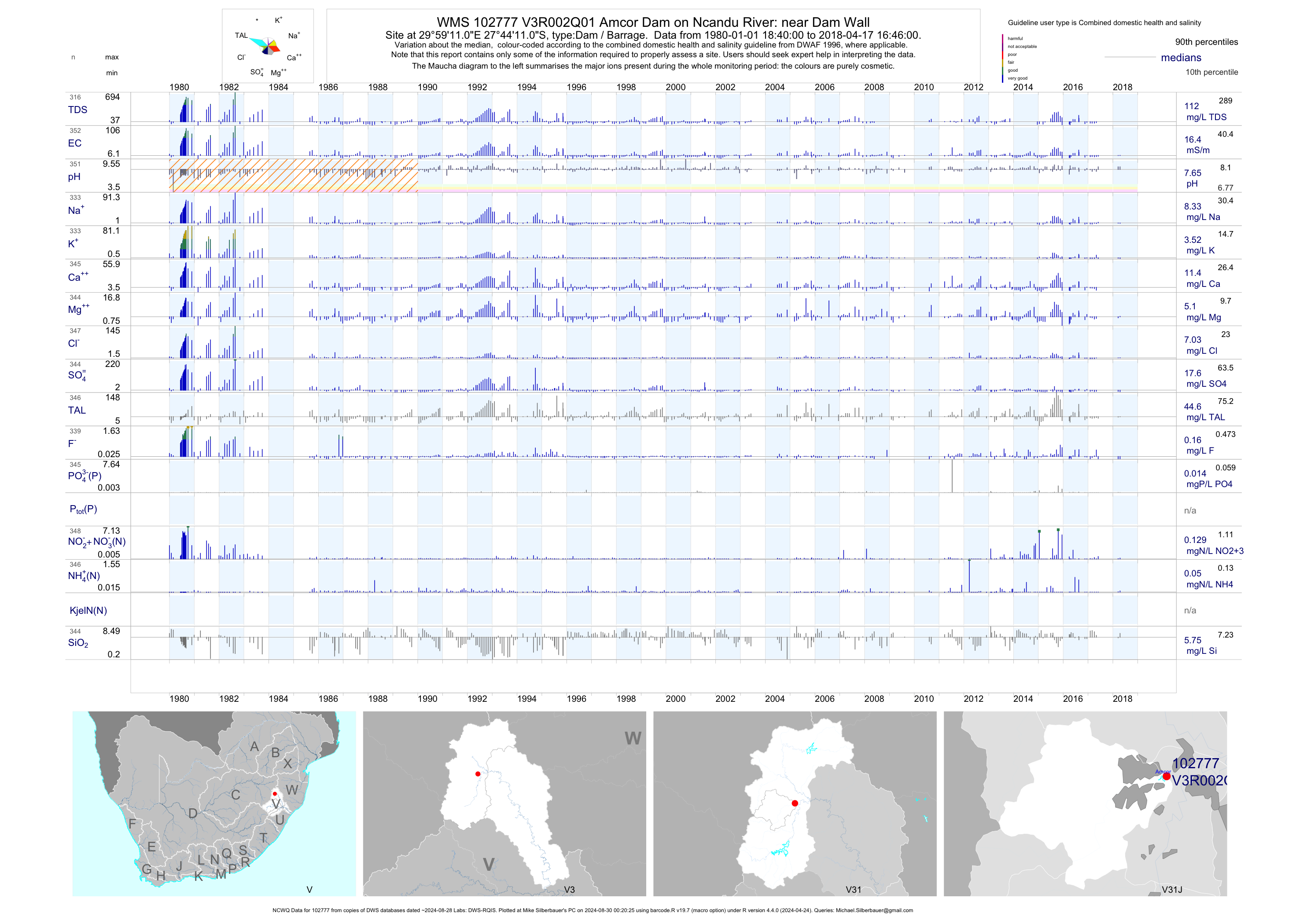
| V31 102777 | plot | data | Amcor Dam on Ncandu River: near Dam Wall (NCWQ) Q01 | Dam / Barrage | 352 | 1980-01-01 | 2018-04-17 | 16 | V3R002 | -27.73639 | 29.98639 |
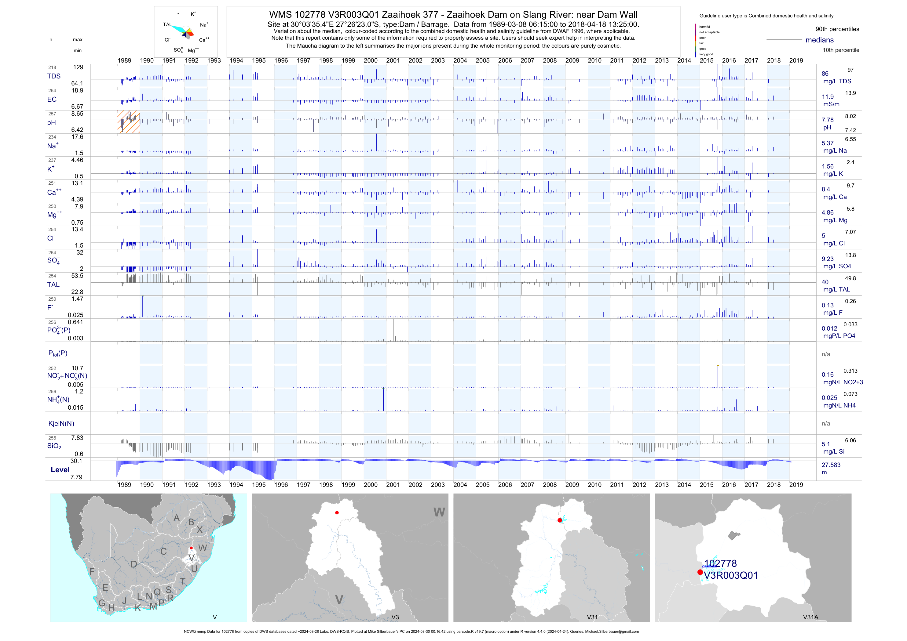
| V31 102778 | plot | data | Zaaihoek 377 - Zaaihoek Dam on Slang River: near Dam Wall (NCWQ nemp) Q01 | Dam / Barrage | 1054 | 1989-03-08 | 2018-04-18 | 12 | V3R003 | -27.43974 | 30.05985 |
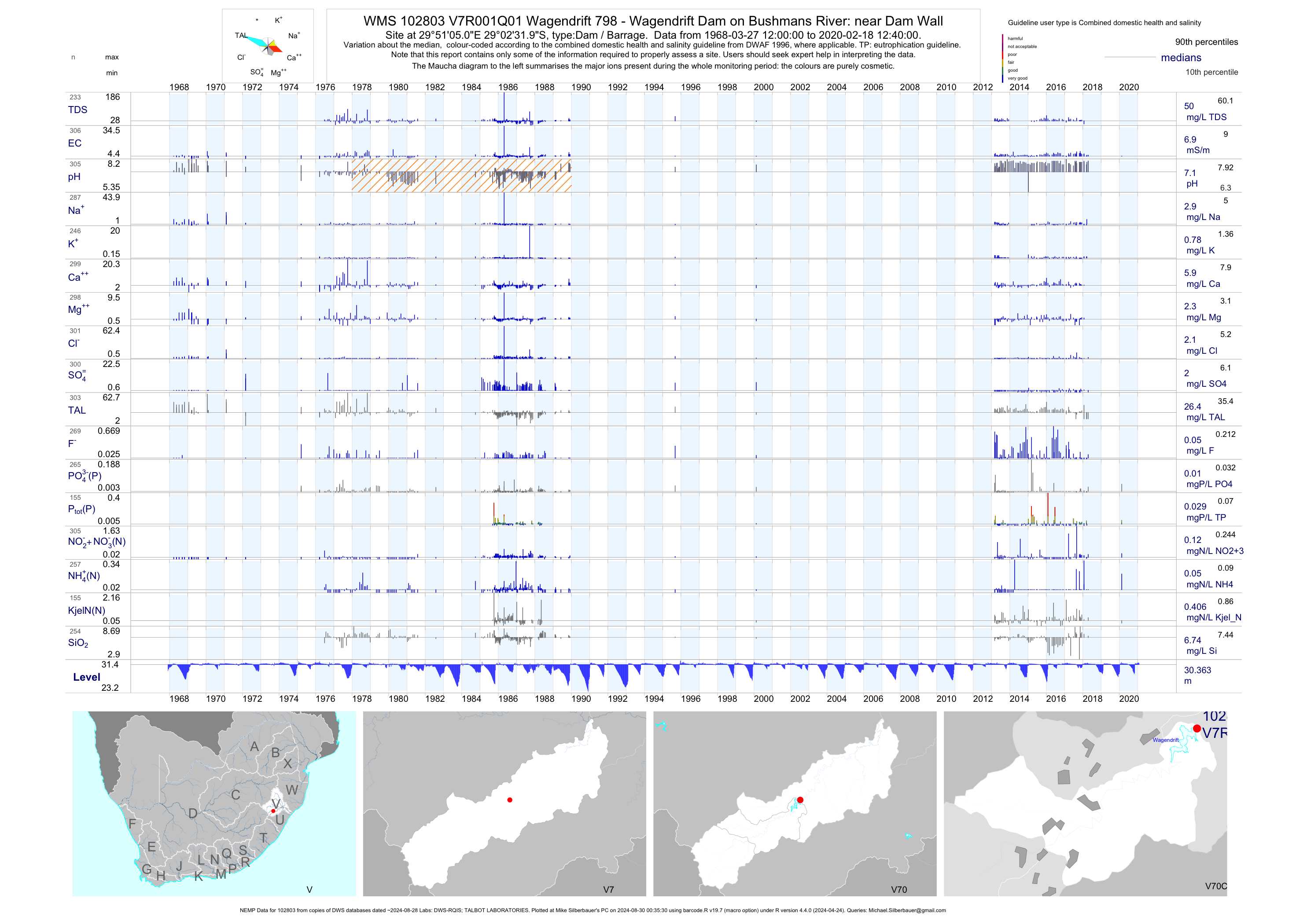
| V70 102803 | plot | data | Wagendrift 798 - Wagendrift Dam on Bushmans River: near Dam Wall (NEMP) Q01 | Dam / Barrage | 988 | 1968-03-27 | 2018-09-06 | 7 | V7R001 | -29.04222 | 29.85139 |
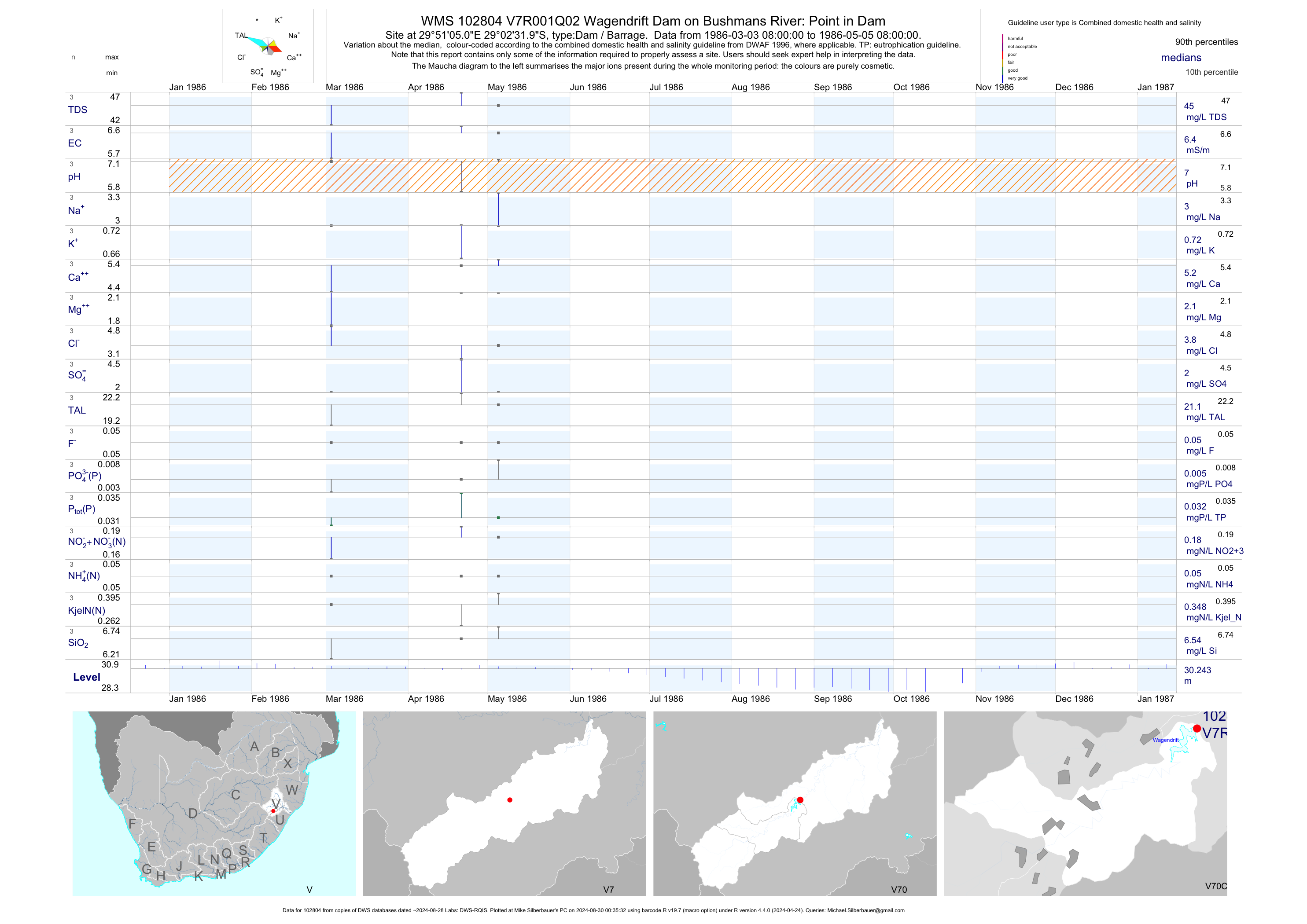
| V70 102804 | plot | data | Wagendrift Dam on Bushmans River: Point in Dam Q02 | Dam / Barrage | 3 | 1986-03-03 | 1986-05-05 | 6 | V7R001 | -29.04222 | 29.85139 |
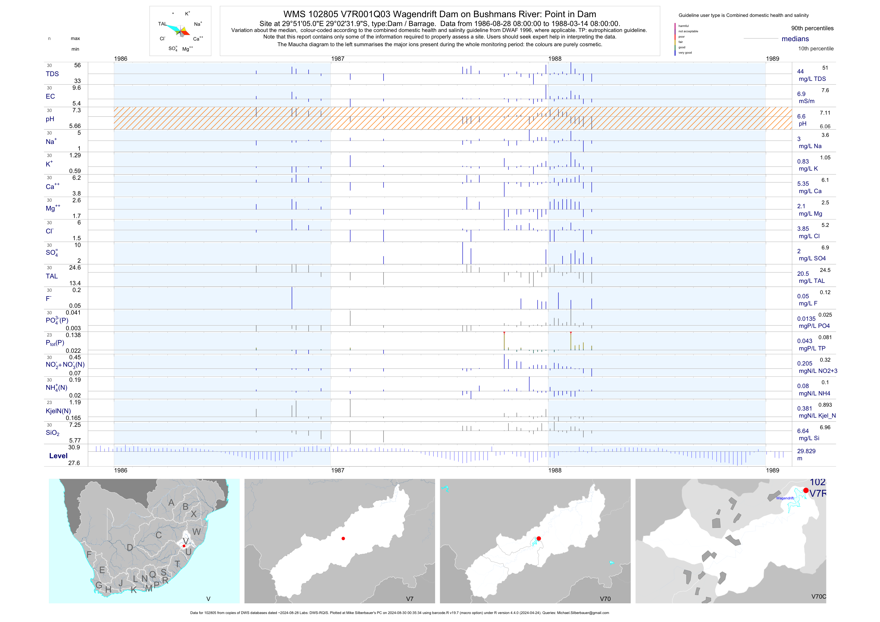
| V70 102805 | plot | data | Wagendrift Dam on Bushmans River: Point in Dam Q03 | Dam / Barrage | 30 | 1986-08-28 | 1988-03-14 | 7 | V7R001 | -29.04222 | 29.85139 |
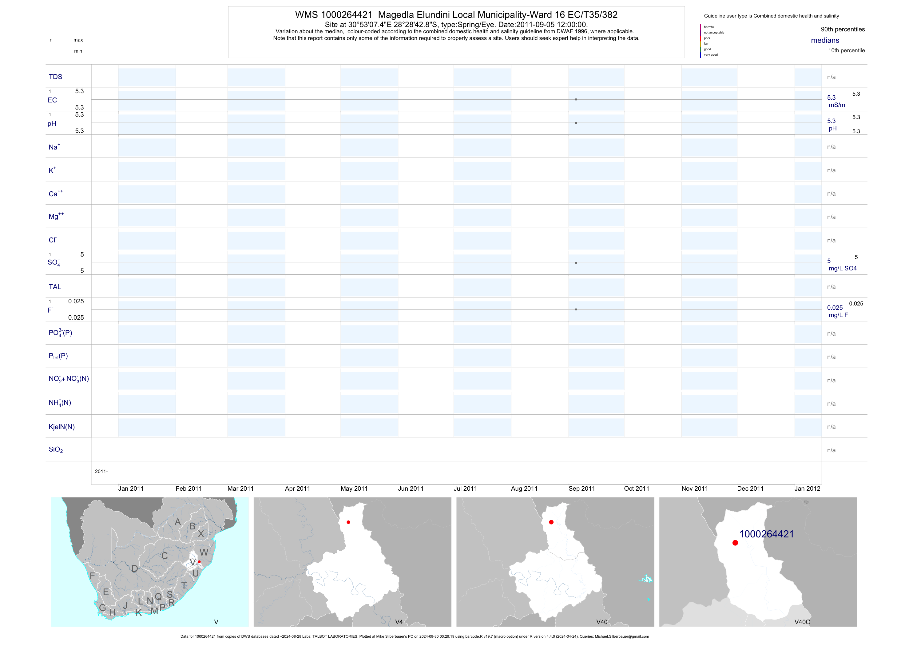
| V40 1000264421 | plot | data | Magedla Elundini Local Municipality-Ward 16 EC/T35/382 | Spring/Eye | 2 | 2011-09-05 | 2011-09-05 | 5 | 1000264421 | -28.47857 | 30.88540 |
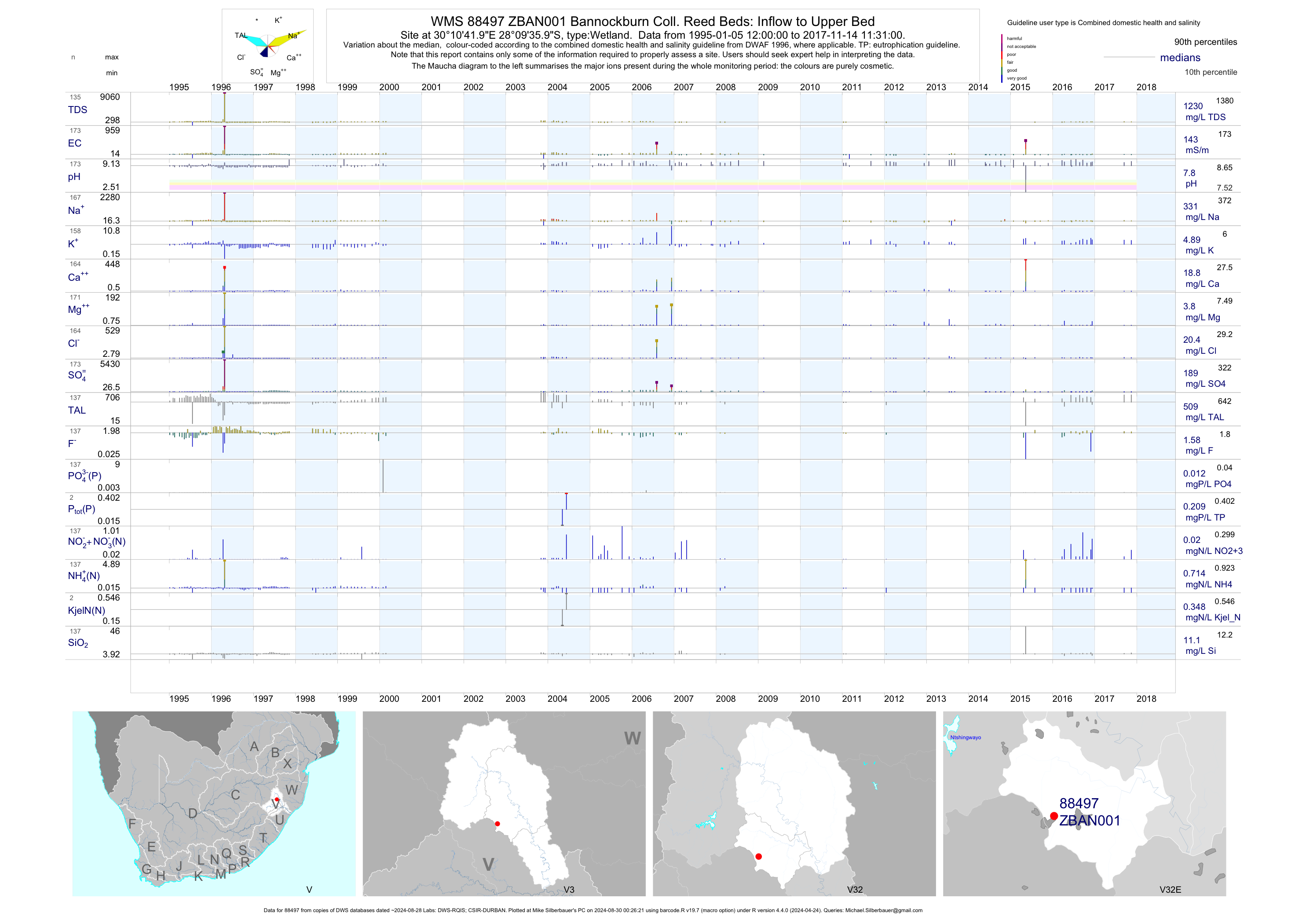
| V32 88497 | plot | data | Bannockburn Coll. Reed Beds: Inflow to Upper Bed | Wetland | 193 | 1995-01-05 | 2017-11-14 | 144 | ZBAN001 | -28.16000 | 30.17833 |
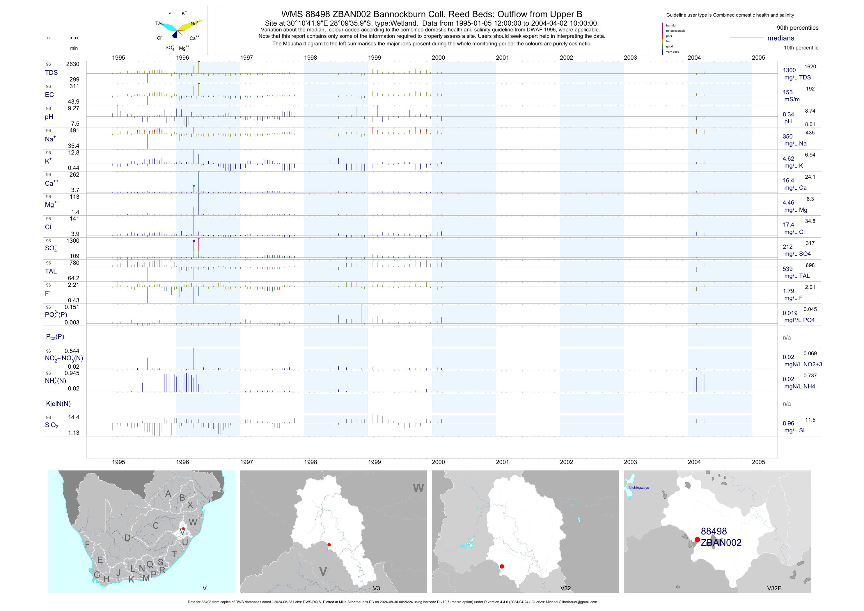
| V32 88498 | plot | data | Bannockburn Coll. Reed Beds: Outflow from Upper B | Wetland | 106 | 1995-01-05 | 2004-04-02 | 155 | ZBAN002 | -28.16000 | 30.17833 |
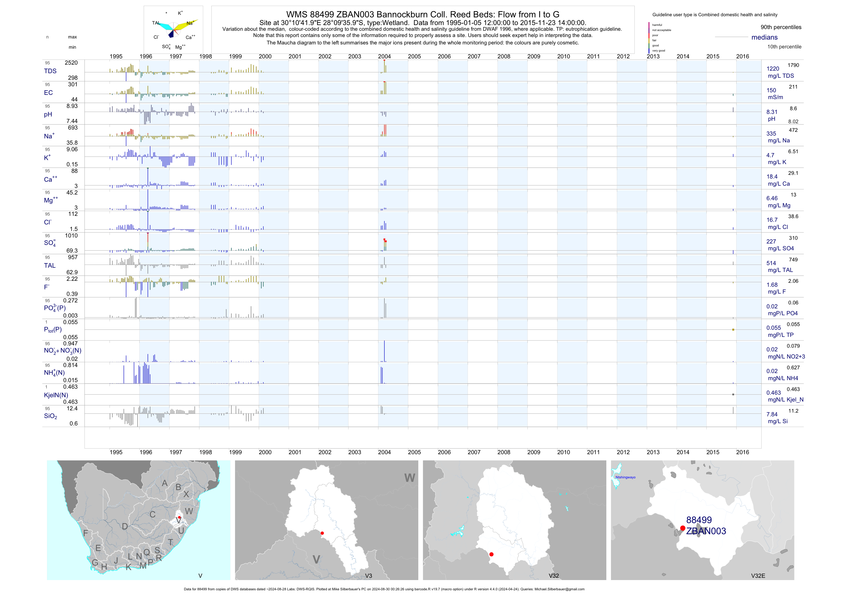
| V32 88499 | plot | data | Bannockburn Coll. Reed Beds: Flow from I to G | Wetland | 105 | 1995-01-05 | 2015-11-23 | 150 | ZBAN003 | -28.16000 | 30.17833 |
| V32 88500 | plot | data | Bannockburn Coll. Reed Beds: Outflow to River | Wetland | 104 | 1995-01-05 | 2004-04-02 | 147 | ZBAN004 | -28.16000 | 30.17833 |
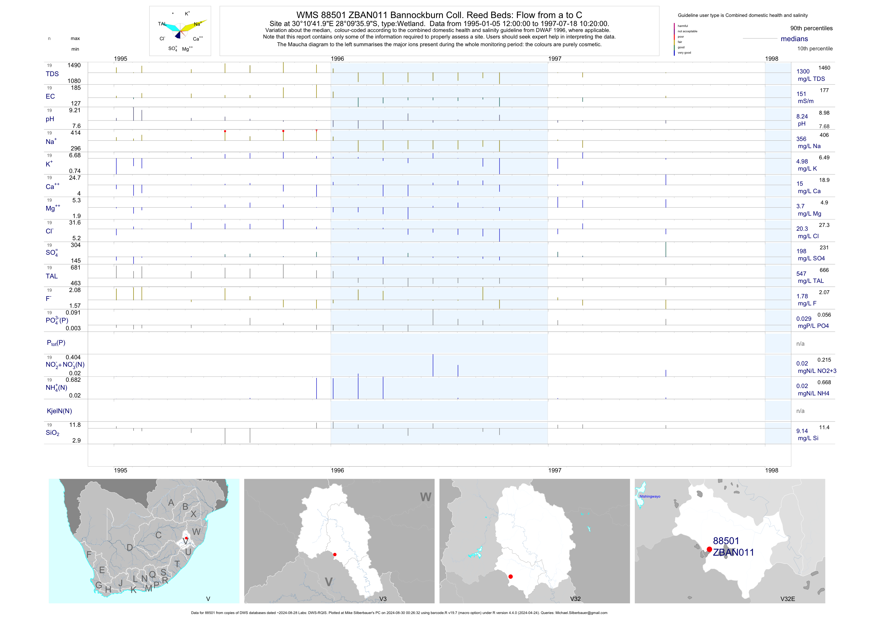
| V32 88501 | plot | data | Bannockburn Coll. Reed Beds: Flow from a to C | Wetland | 19 | 1995-01-05 | 1997-07-18 | 151 | ZBAN011 | -28.16000 | 30.17833 |
| V32 88629 | plot | data | Bannockburn Coll. Reed Beds: Flow from B to C | Wetland | 19 | 1995-01-05 | 1997-07-18 | 151 | ZBAN012 | -28.16000 | 30.17833 |
| V32 88630 | plot | data | Bannockburn Coll. Reed Beds: Flow from C to D | Wetland | 19 | 1995-01-05 | 1997-07-18 | 154 | ZBAN013 | -28.16000 | 30.17833 |
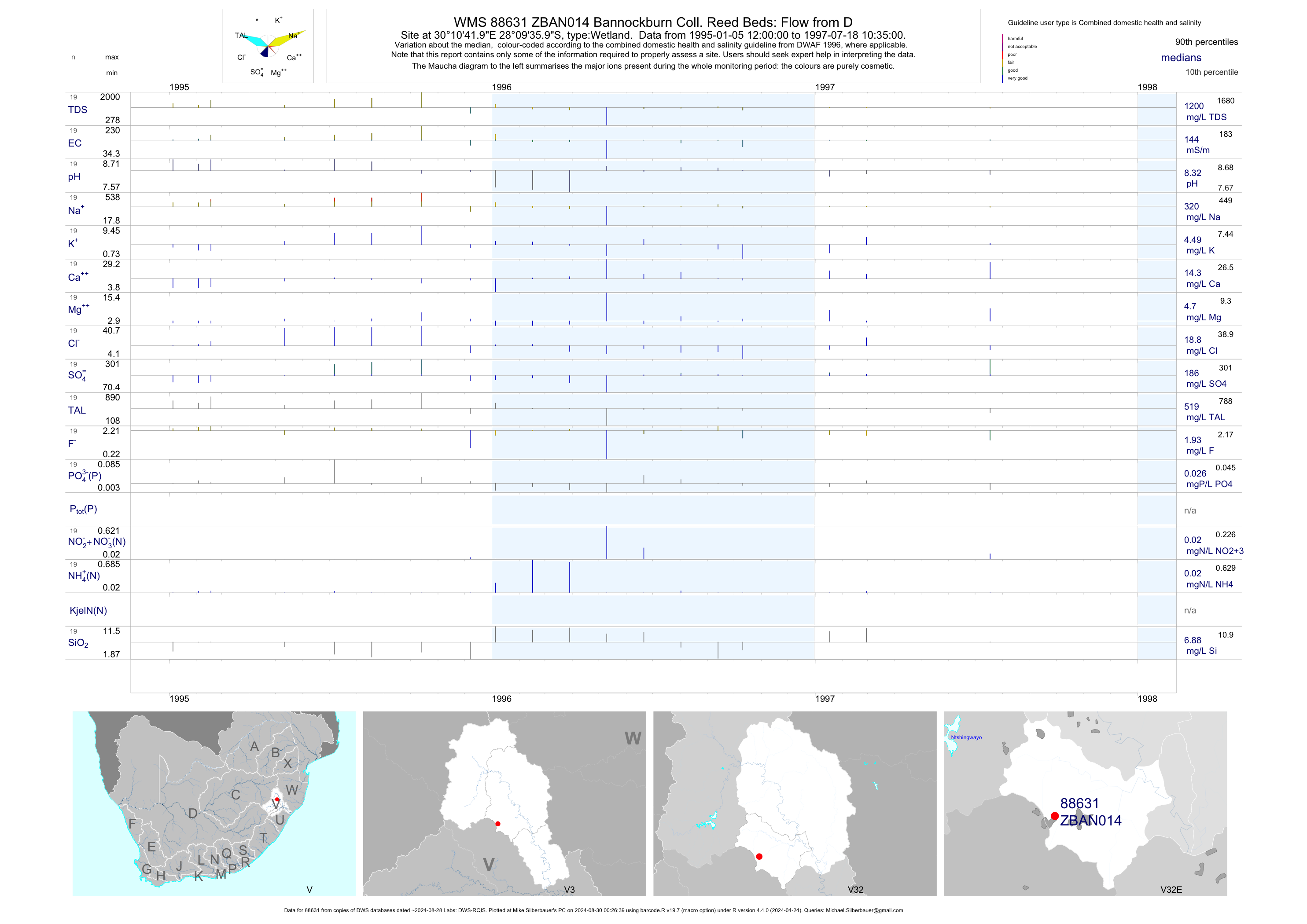
| V32 88631 | plot | data | Bannockburn Coll. Reed Beds: Flow from D | Wetland | 19 | 1995-01-05 | 1997-07-18 | 144 | ZBAN014 | -28.16000 | 30.17833 |
| V32 88632 | plot | data | Bannockburn Coll. Reed Beds: Flow from E to G | Wetland | 19 | 1995-01-05 | 1997-07-18 | 144 | ZBAN015 | -28.16000 | 30.17833 |
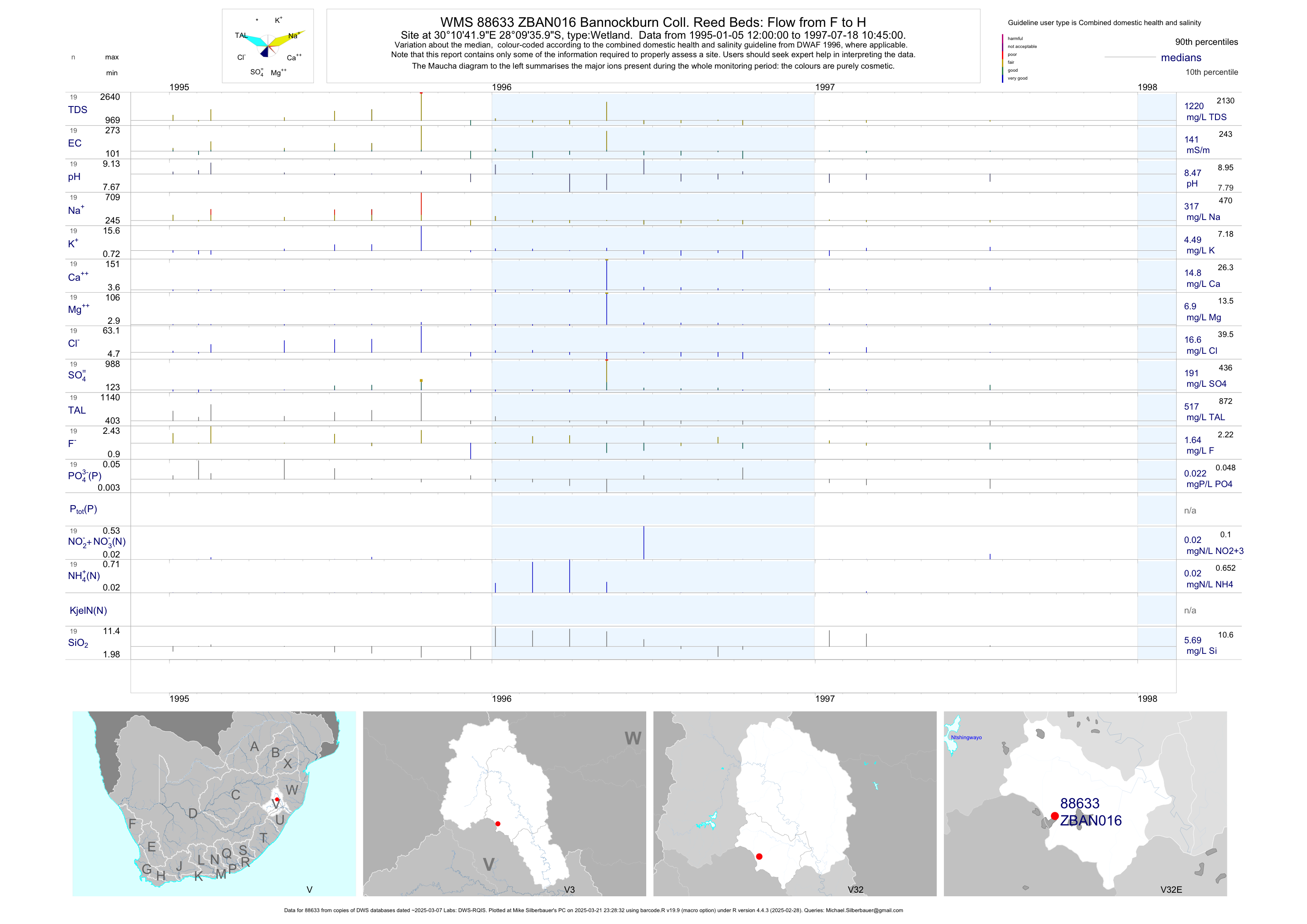
| V32 88633 | plot | data | Bannockburn Coll. Reed Beds: Flow from F to H | Wetland | 19 | 1995-01-05 | 1997-07-18 | 141 | ZBAN016 | -28.16000 | 30.17833 |
| V32 88634 | plot | data | Bannockburn Coll. Reed Beds: Flow from H to I | Wetland | 18 | 1995-01-05 | 1997-07-18 | 140 | ZBAN017 | -28.16000 | 30.17833 |
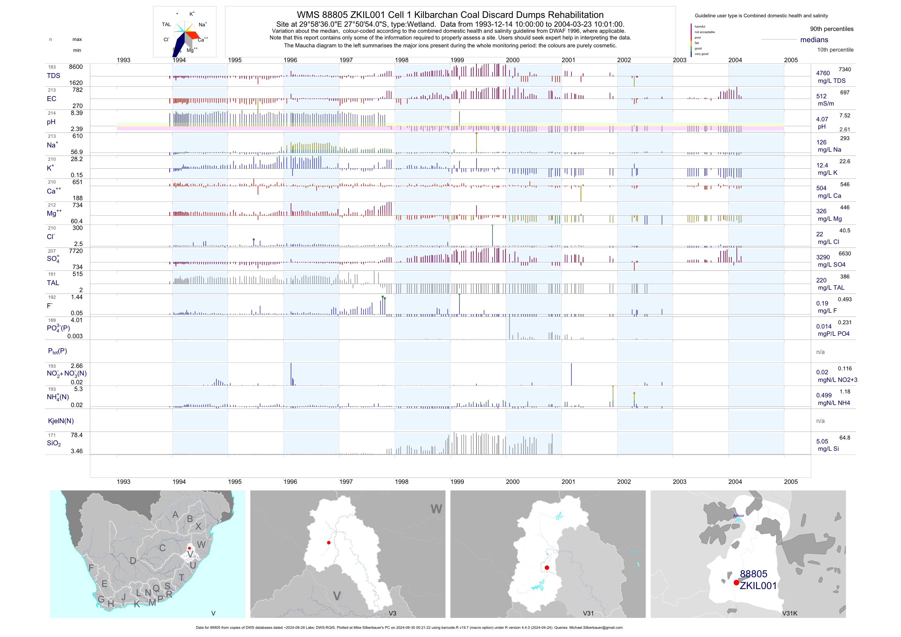
| V31 88805 | plot | data | Cell 1 Kilbarchan Coal Discard Dumps Rehabilitation | Wetland | 299 | 1993-12-14 | 2011-03-03 | 512 | ZKIL001 | -27.84833 | 29.97667 |
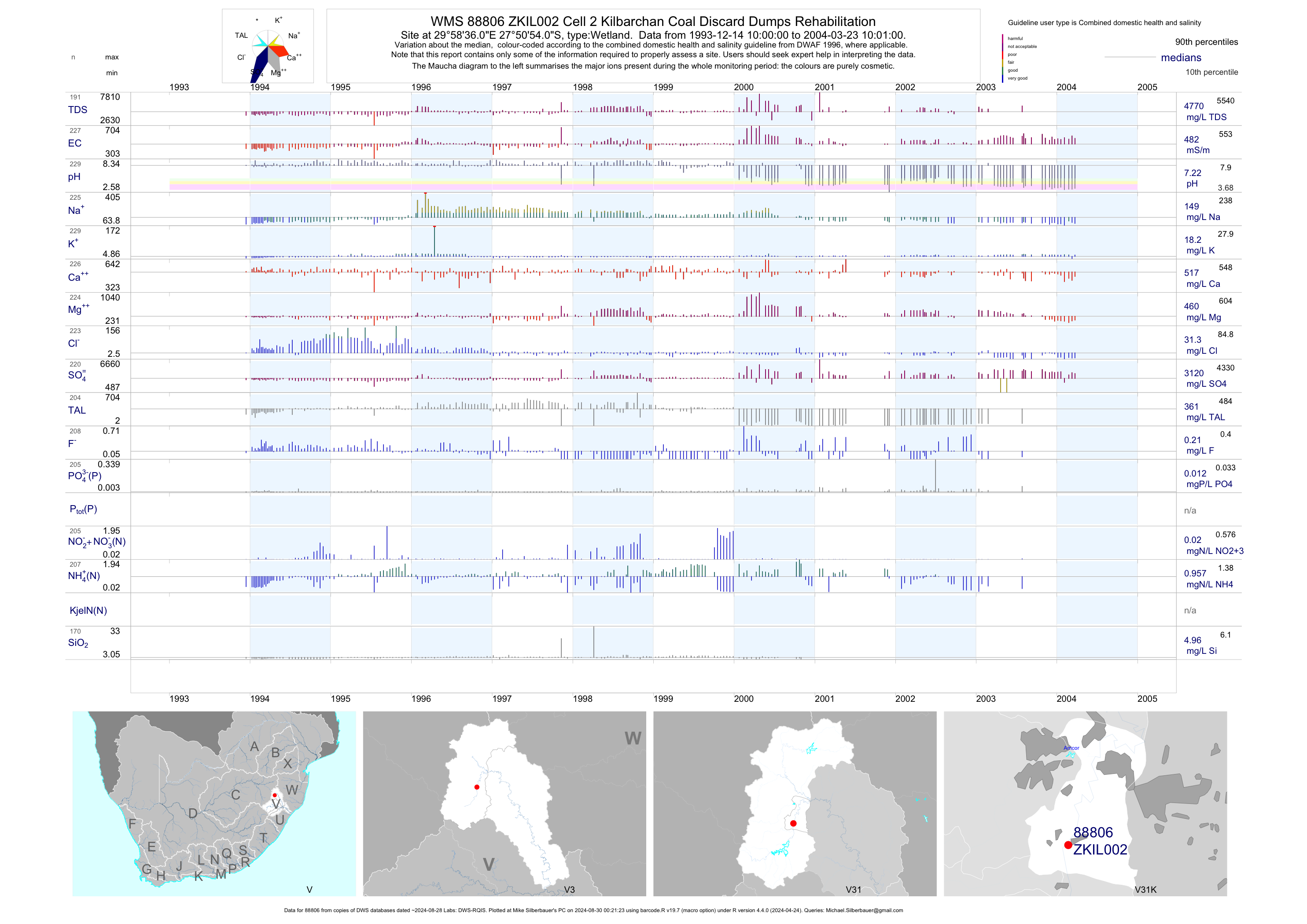
| V31 88806 | plot | data | Cell 2 Kilbarchan Coal Discard Dumps Rehabilitation | Wetland | 312 | 1993-12-14 | 2004-03-23 | 482 | ZKIL002 | -27.84833 | 29.97667 |
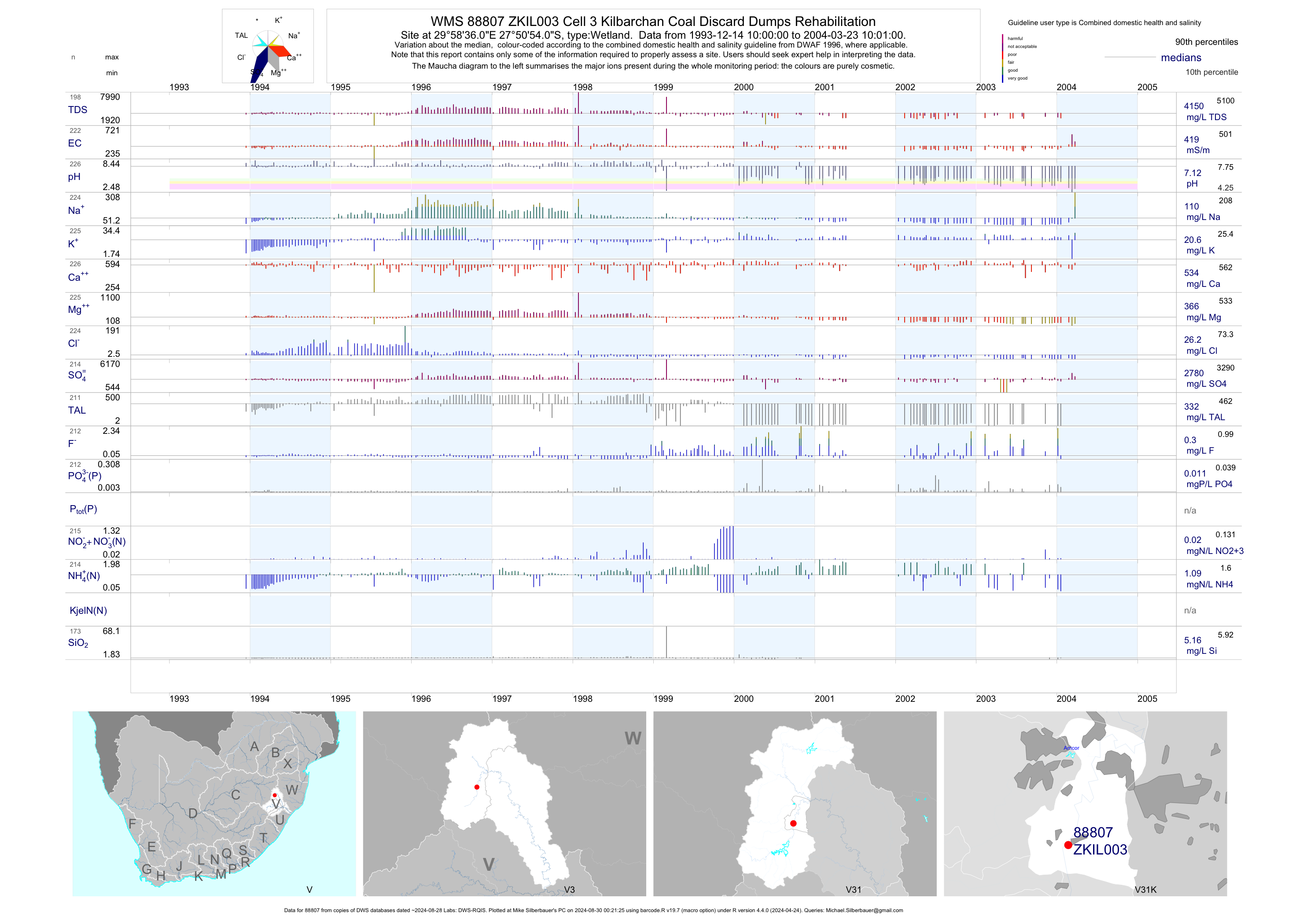
| V31 88807 | plot | data | Cell 3 Kilbarchan Coal Discard Dumps Rehabilitation | Wetland | 308 | 1993-12-14 | 2004-03-23 | 419 | ZKIL003 | -27.84833 | 29.97667 |
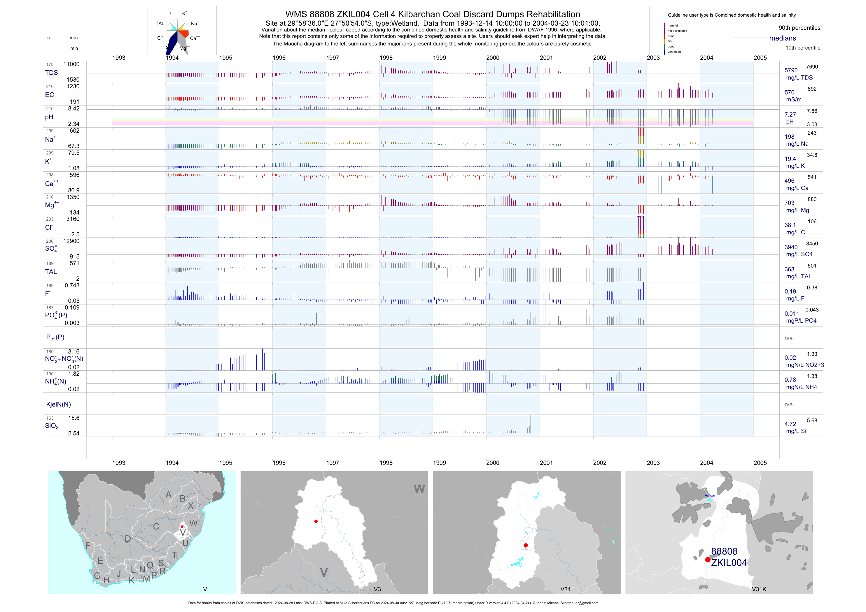
| V31 88808 | plot | data | Cell 4 Kilbarchan Coal Discard Dumps Rehabilitation | Wetland | 294 | 1993-12-14 | 2004-03-23 | 570 | ZKIL004 | -27.84833 | 29.97667 |
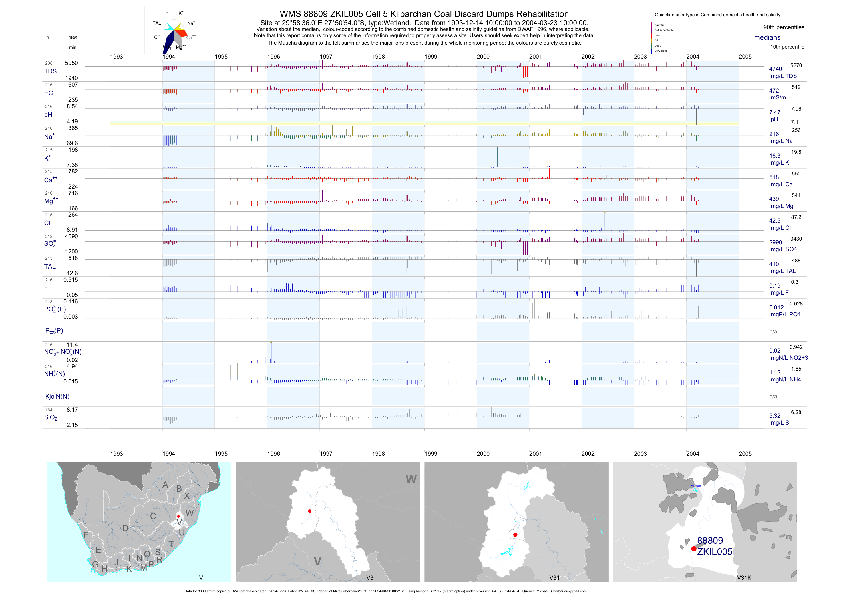
| V31 88809 | plot | data | Cell 5 Kilbarchan Coal Discard Dumps Rehabilitation | Wetland | 300 | 1993-12-14 | 2004-03-23 | 472 | ZKIL005 | -27.84833 | 29.97667 |
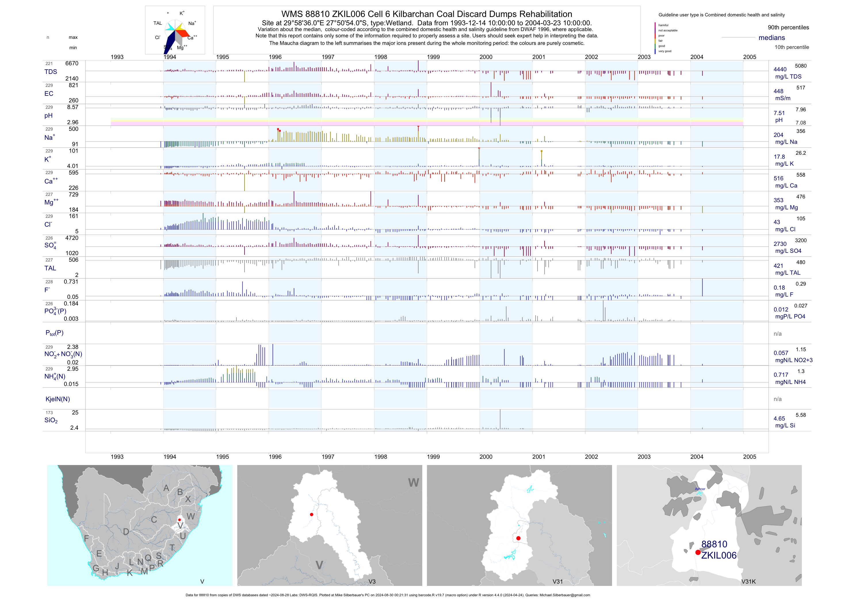
| V31 88810 | plot | data | Cell 6 Kilbarchan Coal Discard Dumps Rehabilitation | Wetland | 305 | 1993-12-14 | 2004-03-23 | 448 | ZKIL006 | -27.84833 | 29.97667 |
| V31 88811 | plot | data | Cell 7 Kilbarchan Coal Discard Dumps Rehabilitation | Wetland | 275 | 1993-12-14 | 2004-03-23 | 423 | ZKIL007 | -27.84833 | 29.97667 |
| V31 88812 | plot | data | Cell 8 Kilbarchan Coal Discard Dumps Rehabilitation | Wetland | 291 | 1993-12-14 | 2003-10-27 | 410 | ZKIL008 | -27.84833 | 29.97667 |
| V31 88813 | plot | data | ZKIL009A Cell 9A Kilbarchan Coal Discard Dumps Rehabilitatio | Wetland | 7 | 1994-02-28 | 2001-04-23 | 66 | 88813 | -27.84833 | 29.97667 |
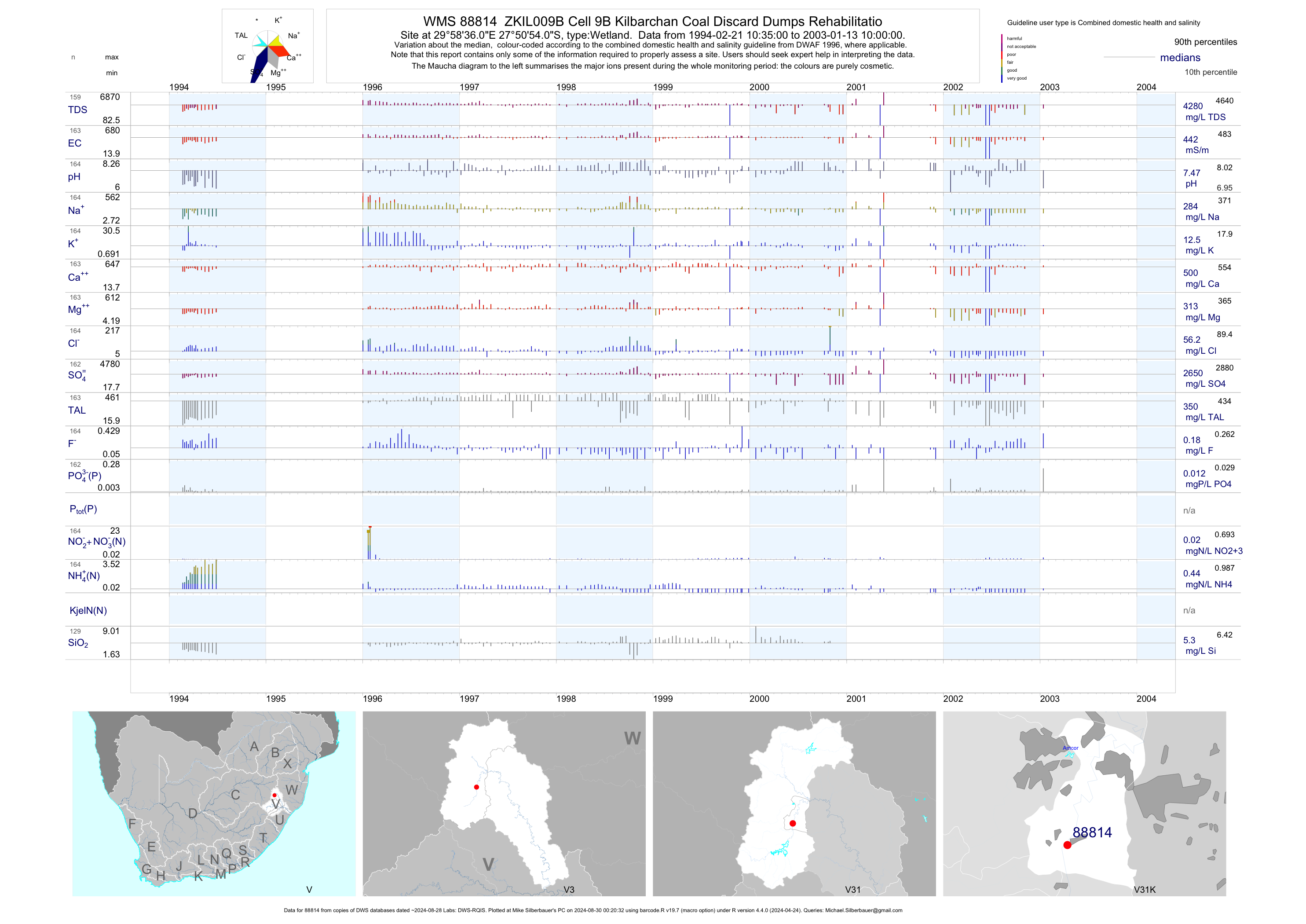
| V31 88814 | plot | data | ZKIL009B Cell 9B Kilbarchan Coal Discard Dumps Rehabilitatio | Wetland | 219 | 1994-02-21 | 2003-01-13 | 442 | 88814 | -27.84833 | 29.97667 |
| V31 88815 | plot | data | ZKIL010A Cell 10A Kilbarchan Coal Discard Dumps Rehabilitati | Wetland | 11 | 1994-01-18 | 2001-11-26 | 429 | 88815 | -27.84833 | 29.97667 |
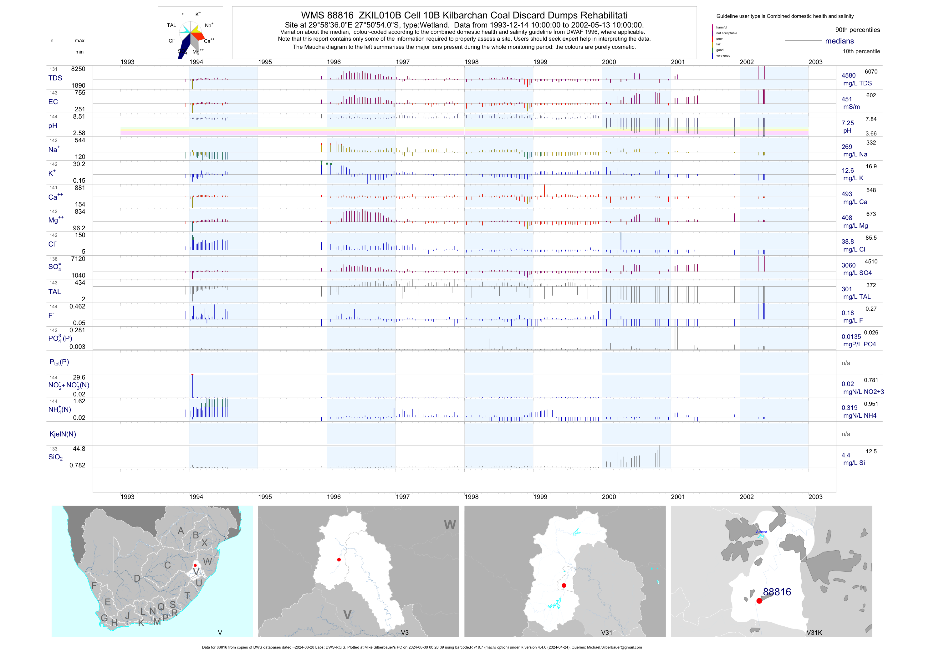
| V31 88816 | plot | data | ZKIL010B Cell 10B Kilbarchan Coal Discard Dumps Rehabilitati | Wetland | 188 | 1993-12-14 | 2002-10-13 | 451 | 88816 | -27.84833 | 29.97667 |
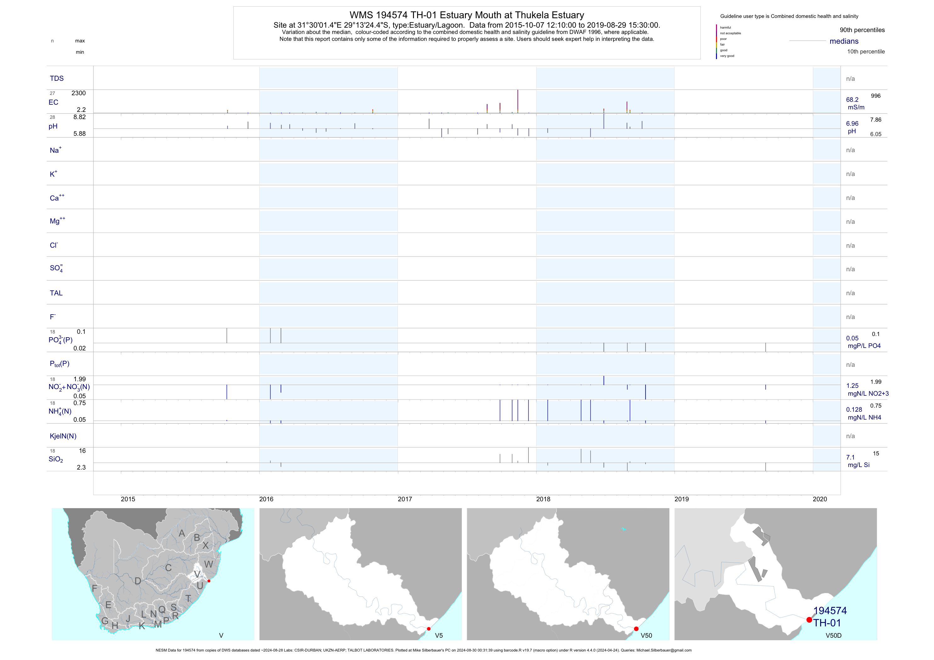
| V50 194574 | plot | data | Estuary Mouth at Thukela Estuary (NESM) | Estuary/Lagoon | 80 | 2015-10-07 | 2018-10-16 | 68 | TH-01 | -29.22346 | 31.50040 |
| V50 194575 | plot | data | Ultimatum Tree at Thukela Estuary (NESM) | Estuary/Lagoon | 82 | 2015-10-06 | 2018-10-16 | 31 | TH-02 | -29.21411 | 31.43556 |
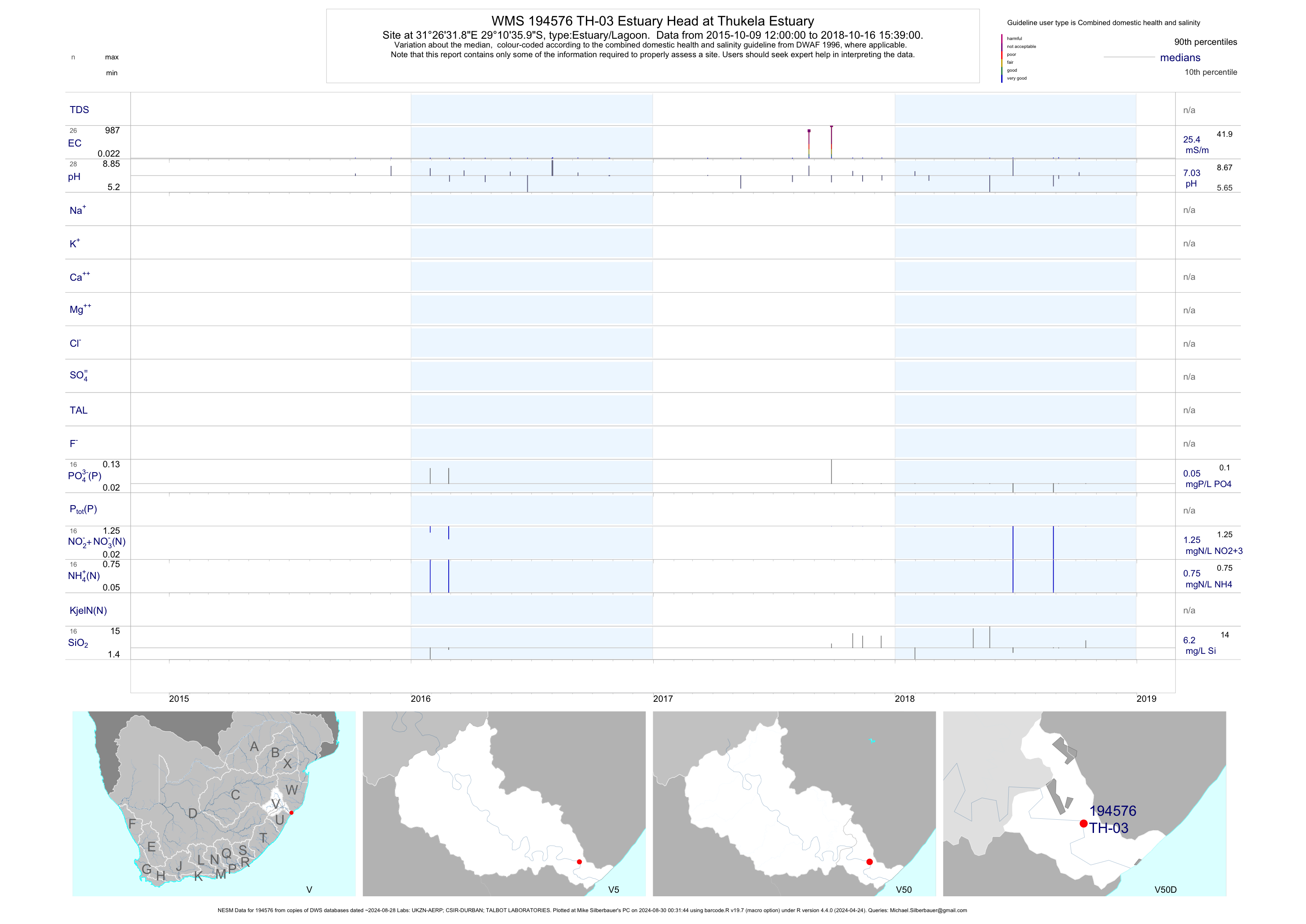
| V50 194576 | plot | data | Estuary Head at Thukela Estuary (NESM) | Estuary/Lagoon | 75 | 2015-10-06 | 2018-10-16 | 27 | TH-03 | -29.17667 | 31.44219 |
| V31 103075 | plot | data | Ngagane Treatment Works - Celmsford Dam Raw Water | Potable Water Treatment Works | 223 | 1979-11-01 | 2012-11-29 | 24 | V3H021 | -27.79806 | 29.98889 |
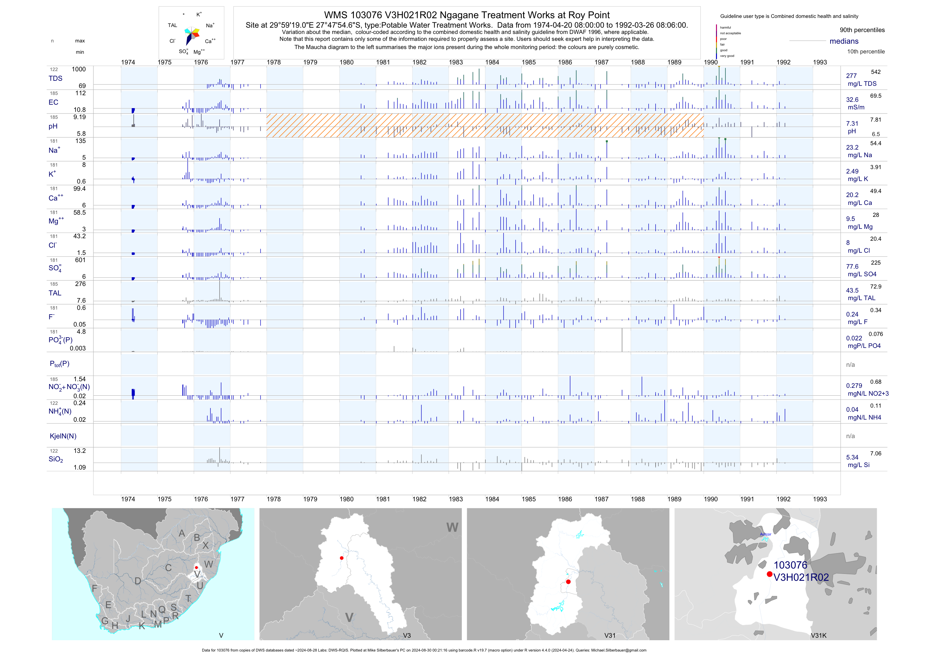
| V31 103076 | plot | data | Ngagane Treatment Works at Roy Point | Potable Water Treatment Works | 232 | 1974-04-20 | 1992-03-26 | 33 | V3H021 | -27.79850 | 29.98864 |
| V31 103078 | plot | data | Ngagane Treatment Works - Treated Water | Potable Water Treatment Works | 242 | 1979-11-01 | 1992-03-26 | 26 | V3H021 | -27.79806 | 29.98889 |
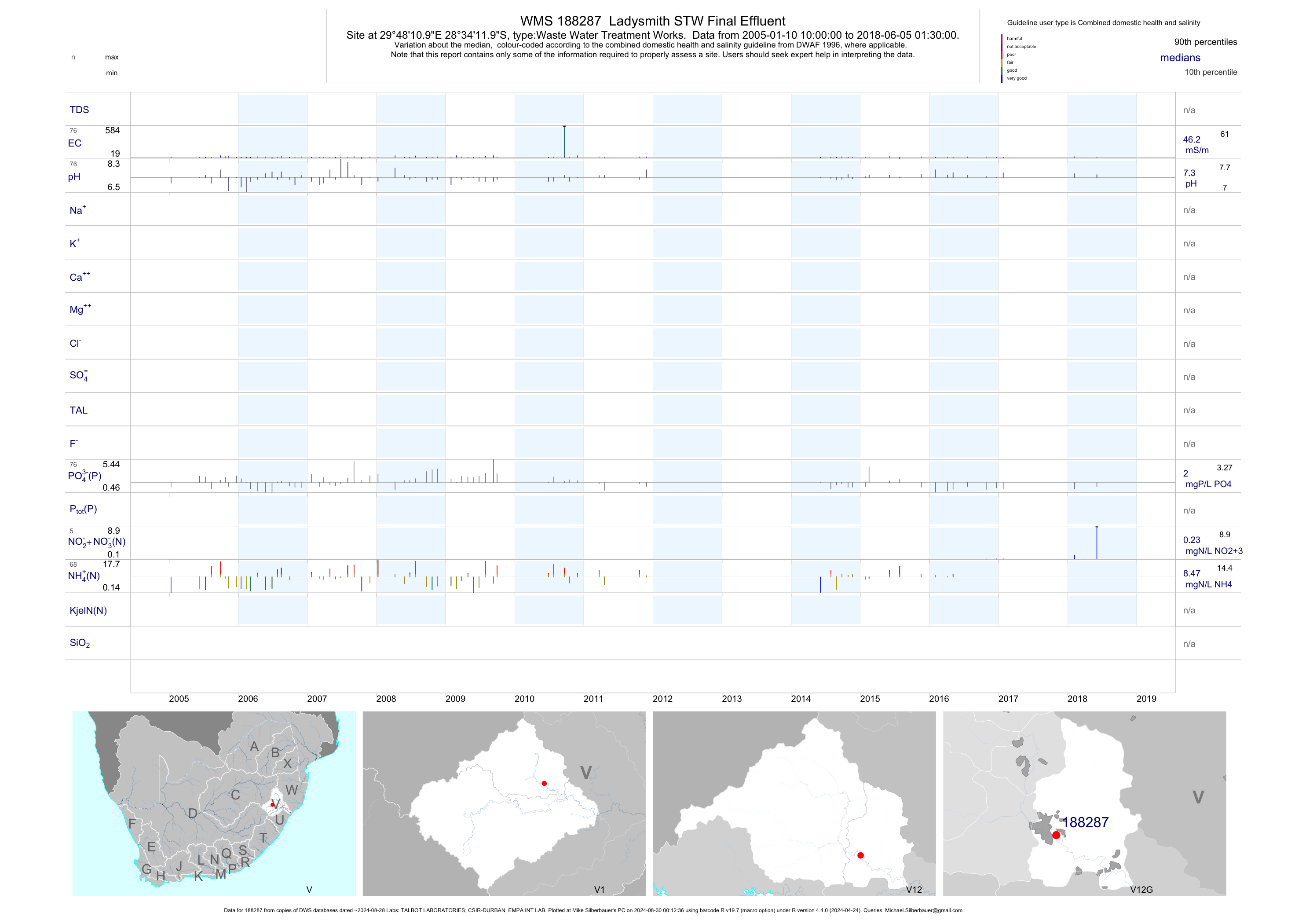
| V12 188287 | plot | data | Ladysmith STW Final Effluent | Waste Water Treatment Works | 109 | 2005-01-10 | 2017-03-16 | 46 | 188287 | -28.57000 | 29.80306 |
| V11 188294 | plot | data | Royal National Park STW | Waste Water Treatment Works | 76 | 2005-01-12 | 2017-02-28 | 13 | 188294 | -28.68639 | 28.95694 |
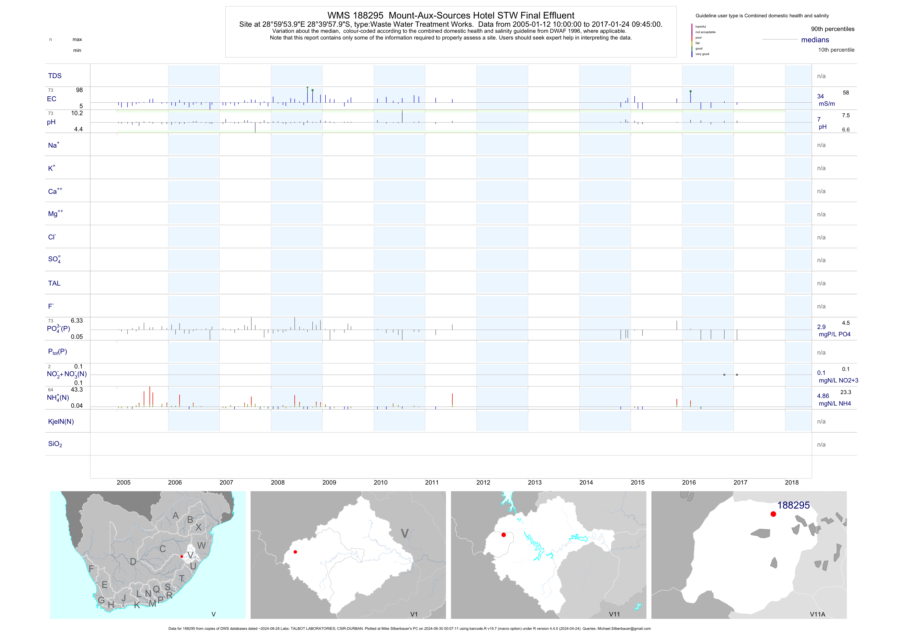
| V11 188295 | plot | data | Mount-Aux-Sources Hotel STW Final Effluent | Waste Water Treatment Works | 104 | 2005-01-12 | 2017-02-28 | 34 | 188295 | -28.66611 | 28.99833 |
| V11 188297 | plot | data | Bergville STW Final Effluent | Waste Water Treatment Works | 101 | 2005-01-13 | 2017-01-23 | 34 | 188297 | -28.72972 | 29.35750 |
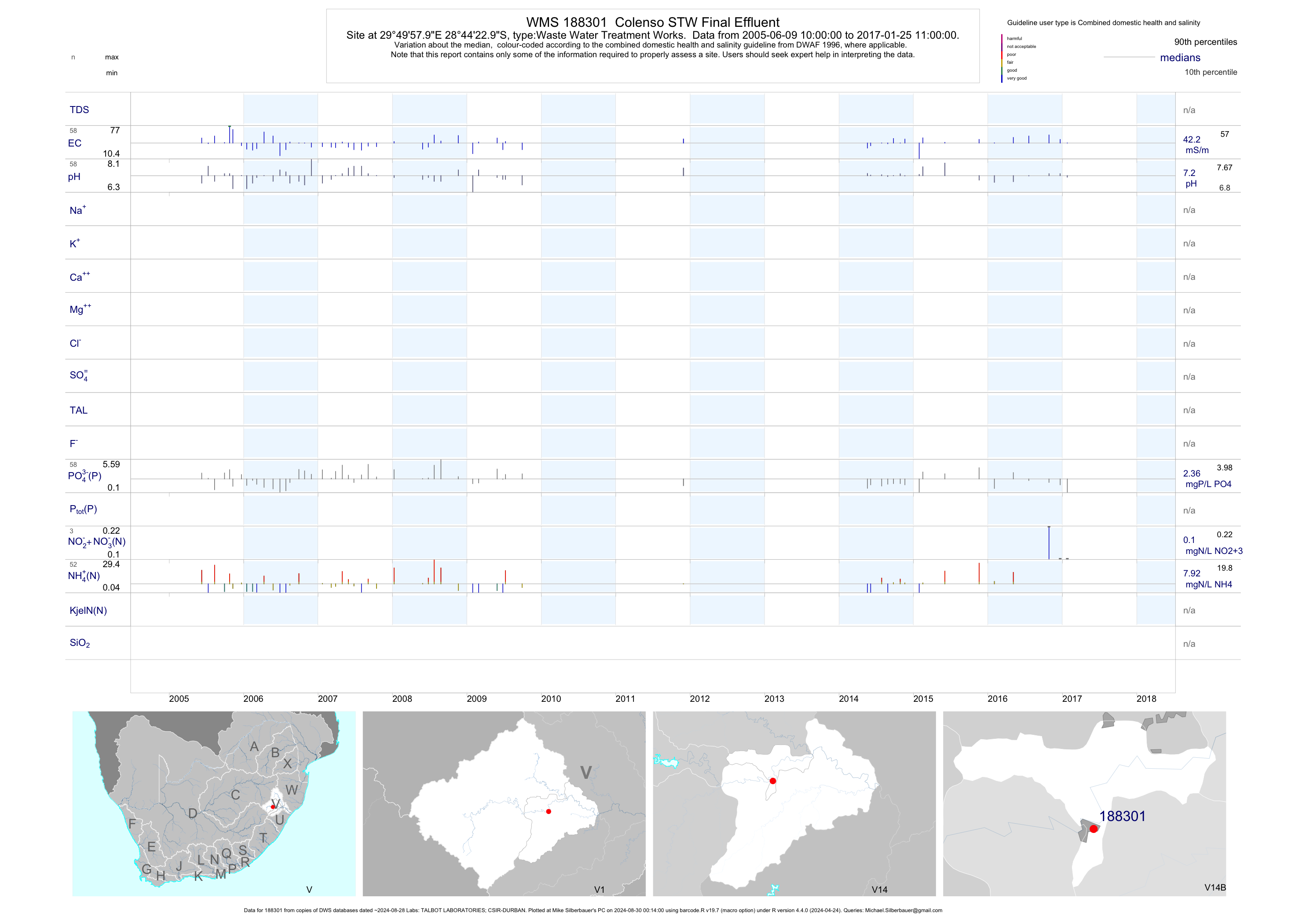
| V14 188301 | plot | data | Colenso STW Final Effluent | Waste Water Treatment Works | 88 | 2005-06-09 | 2018-06-05 | 42 | 188301 | -28.73972 | 29.83278 |
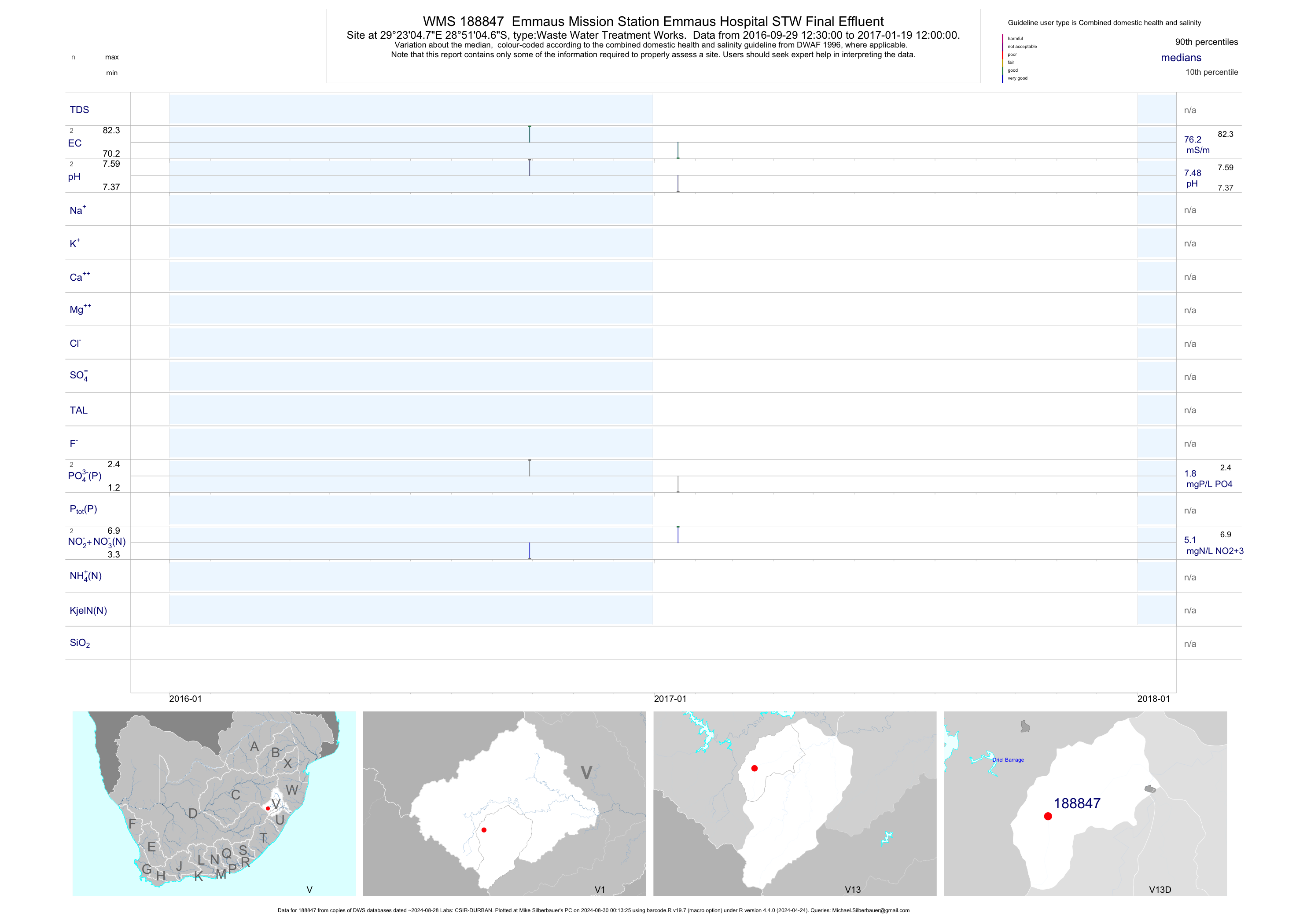
| V13 188847 | plot | data | Emmaus Mission Station Emmaus Hospital STW Final Effluent | Waste Water Treatment Works | 8 | 2016-09-29 | 2017-03-15 | 76 | 188847 | -28.85131 | 29.38467 |
| V11 188853 | plot | data | Cathedral Peak Hotel STW Final Effluent Discharge to Mlambonja | Waste Water Treatment Works | 86 | 2005-03-31 | 2017-03-15 | 41 | 188853 | -28.94642 | 29.20939 |
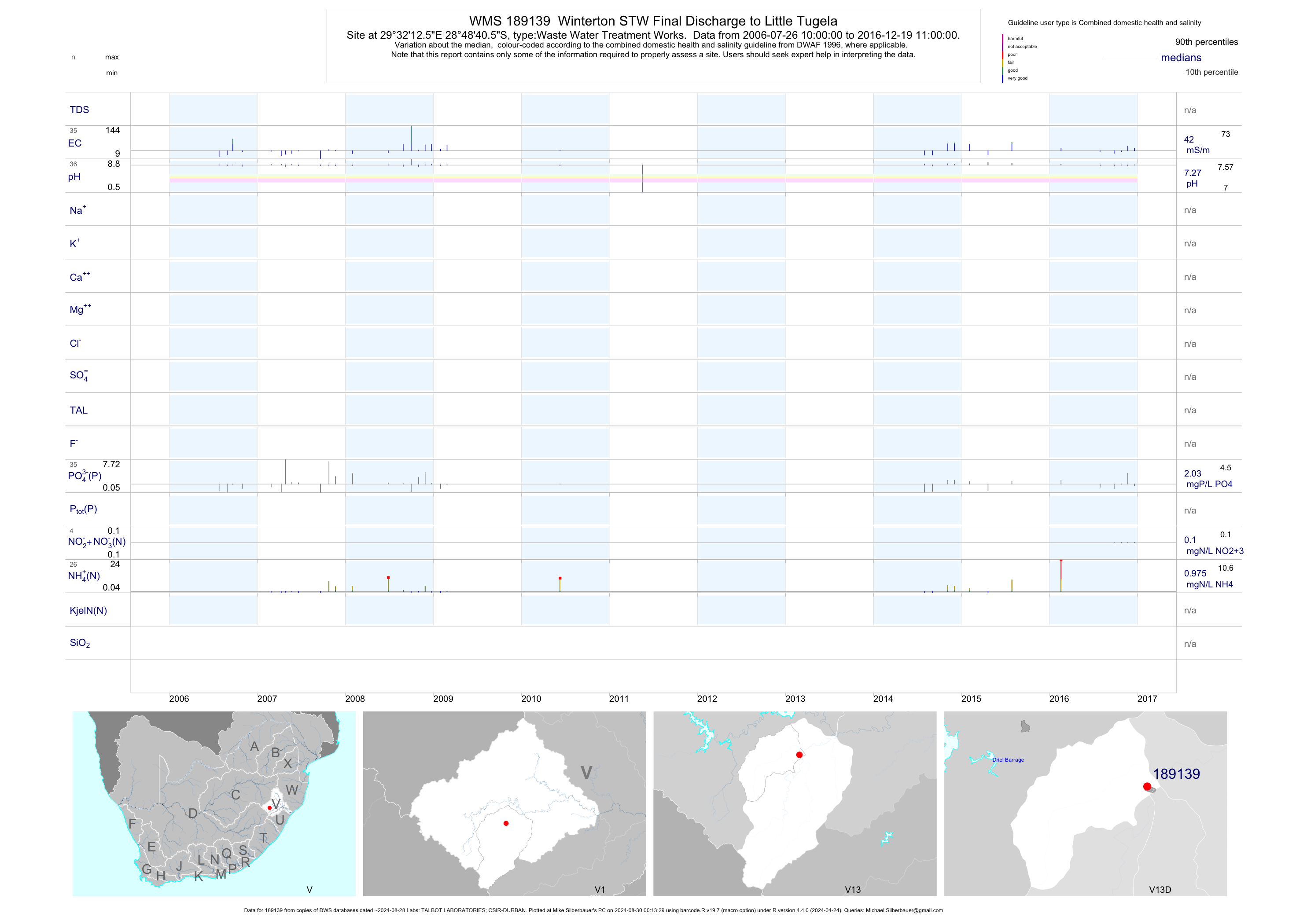
| V13 189139 | plot | data | Winterton STW Final Discharge to Little Tugela | Waste Water Treatment Works | 49 | 2006-07-26 | 2016-12-19 | 42 | 189139 | -28.81128 | 29.53681 |
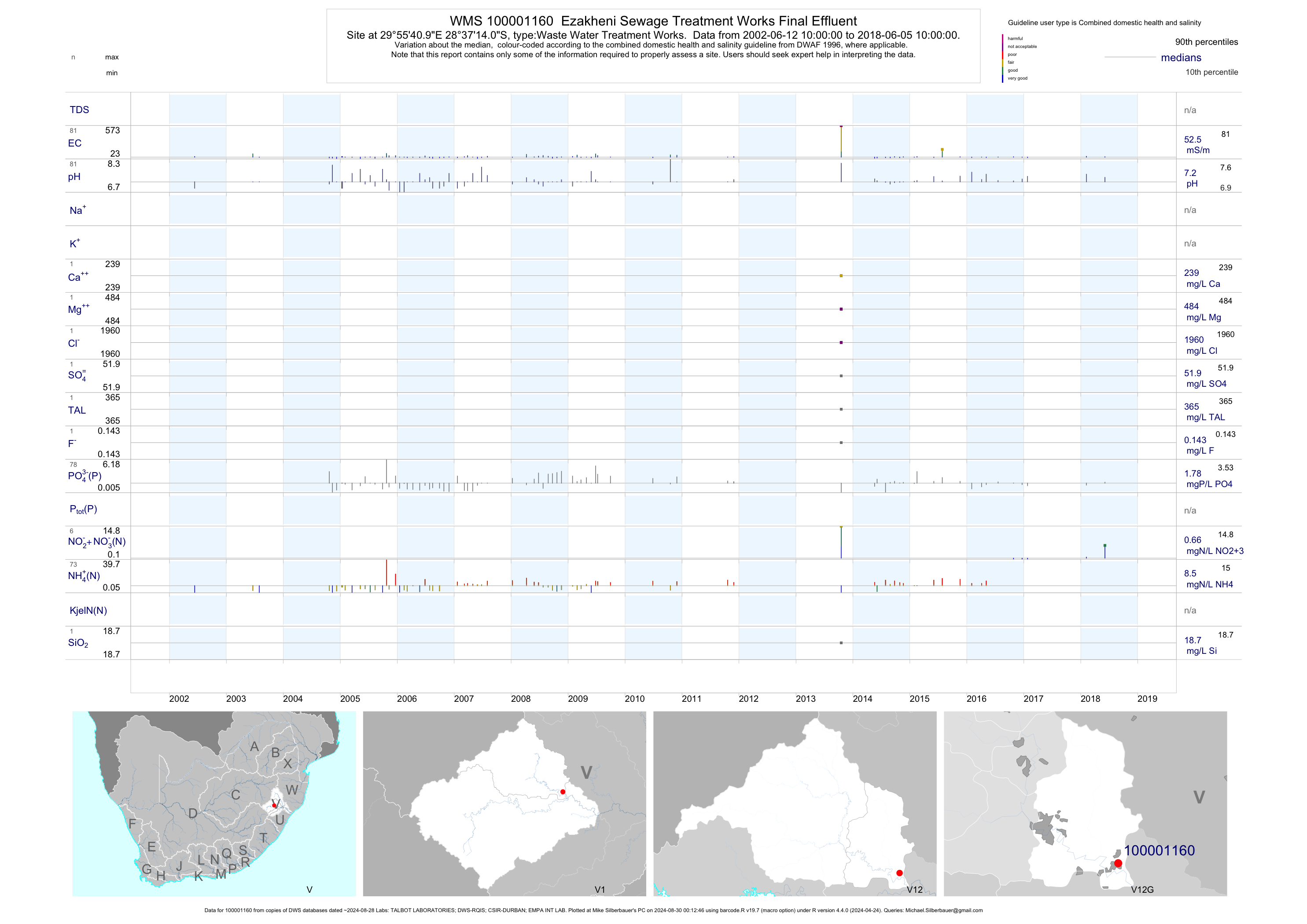
| V12 100001160 | plot | data | Ezakheni Sewage Treatment Works Final Effluent | Waste Water Treatment Works | 96 | 2002-06-12 | 2018-06-05 | 52 | 1-1160 | -28.62056 | 29.92806 |
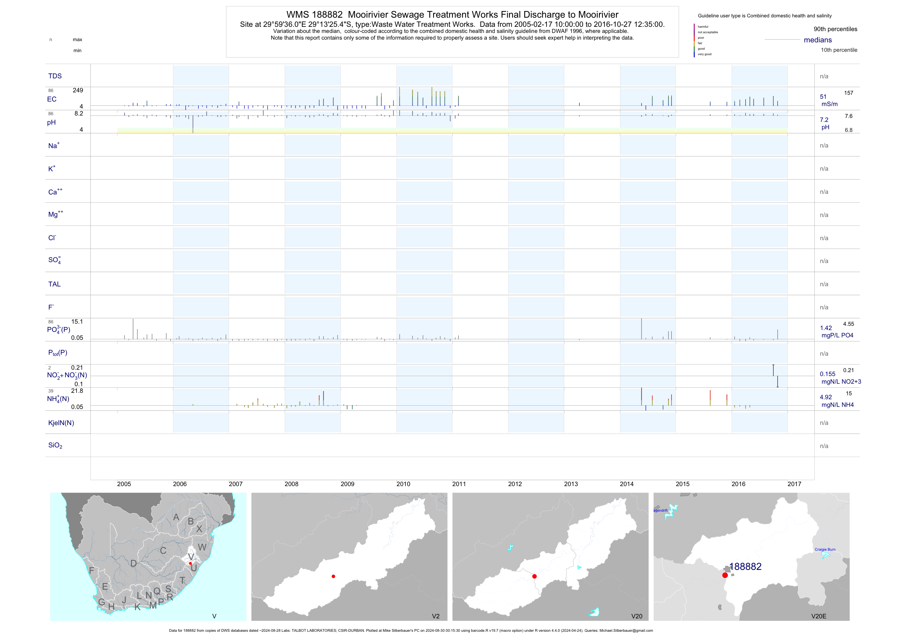
| V20 188882 | plot | data | Mooirivier Sewage Treatment Works Final Discharge to Mooirivier | Waste Water Treatment Works | 119 | 2005-02-17 | 2016-10-27 | 50 | 188882 | -29.22372 | 29.99336 |
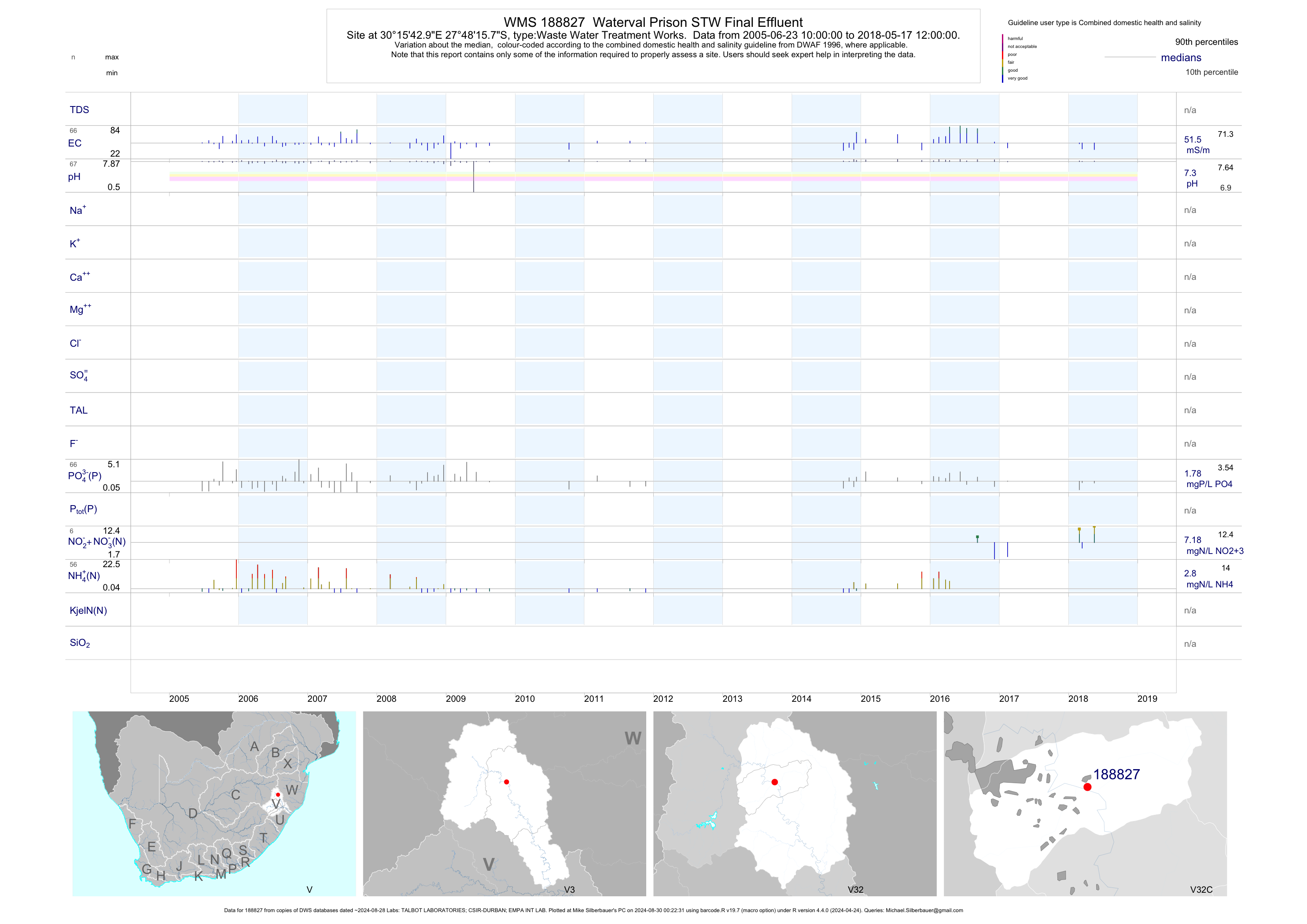
| V32 188827 | plot | data | Waterval Prison STW Final Effluent | Waste Water Treatment Works | 96 | 2005-06-23 | 2017-03-13 | 52 | 188827 | -27.80439 | 30.26192 |
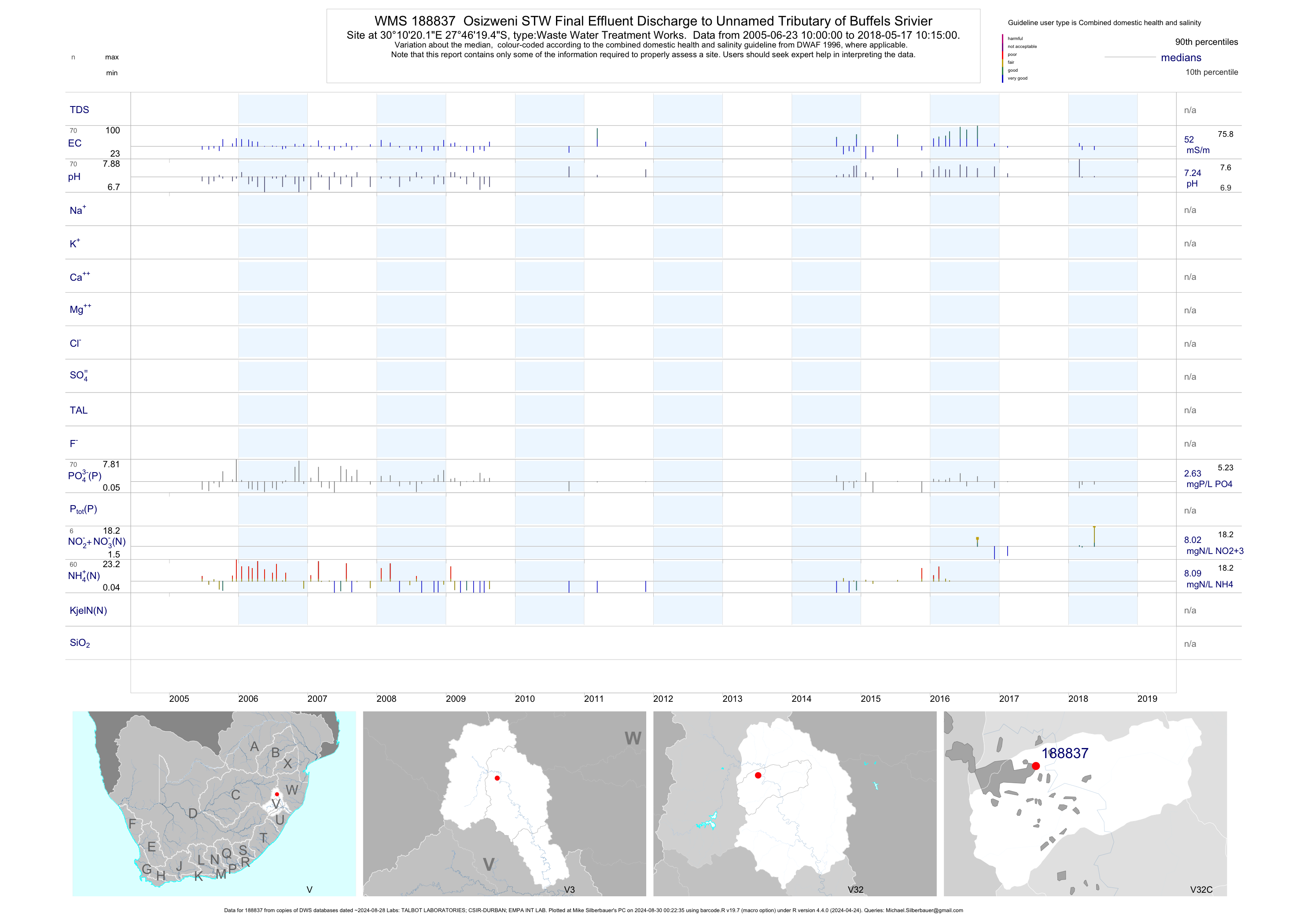
| V32 188837 | plot | data | Osizweni STW Final Effluent Discharge to Unnamed Tributary of Buffels Srivier | Waste Water Treatment Works | 98 | 2005-06-23 | 2017-03-13 | 52 | 188837 | -27.77208 | 30.17228 |
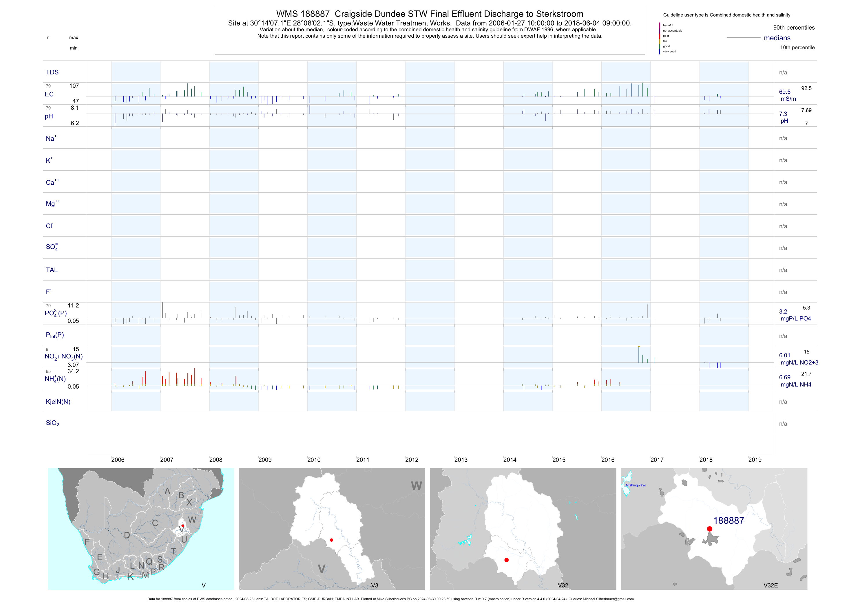
| V32 188887 | plot | data | Craigside Dundee STW Final Effluent Discharge to Sterkstroom | Waste Water Treatment Works | 100 | 2006-01-27 | 2017-02-06 | 72 | 188887 | -28.13392 | 30.23533 |
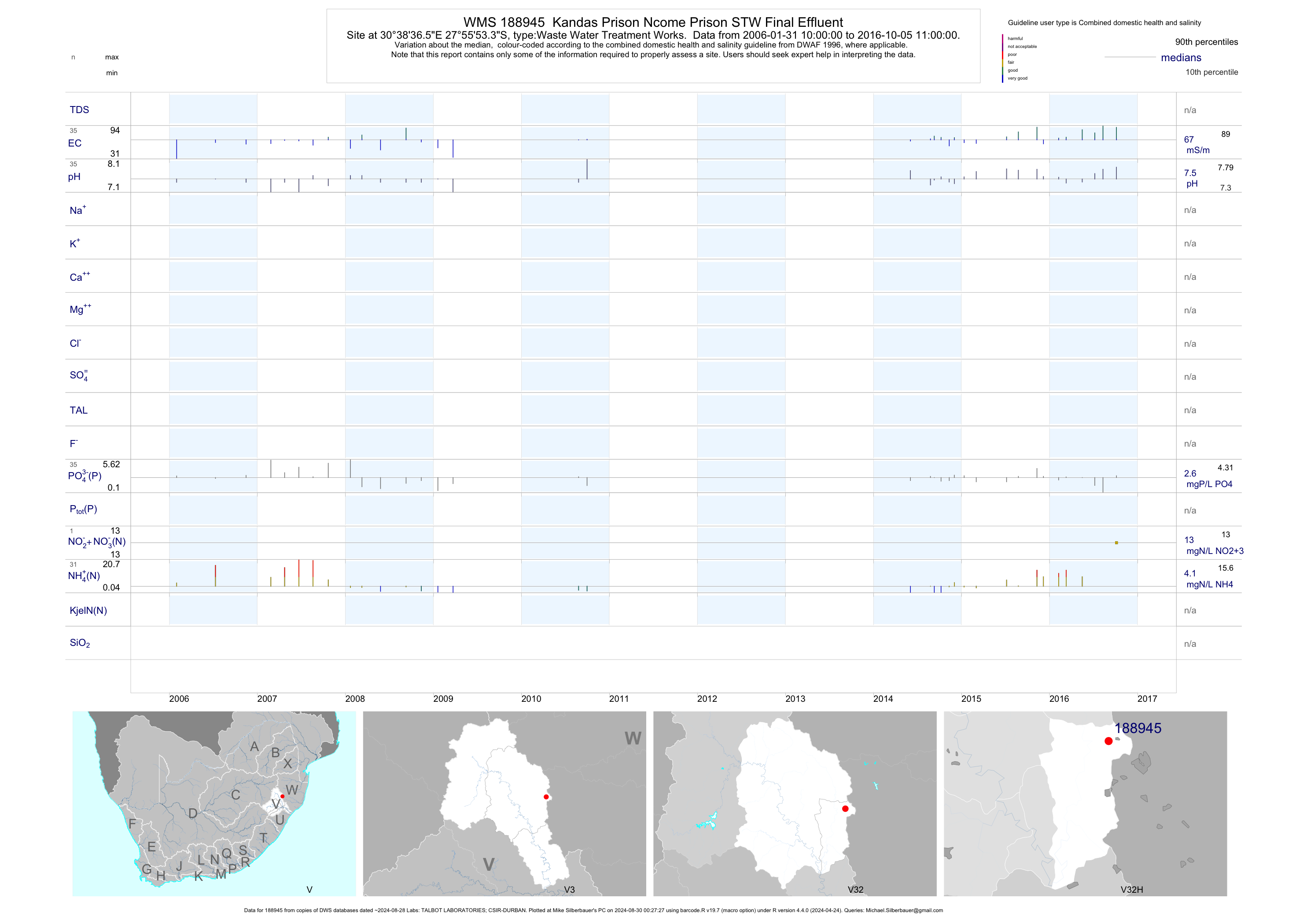
| V32 188945 | plot | data | Kandas Prison Ncome Prison STW Final Effluent | Waste Water Treatment Works | 47 | 2006-01-31 | 2016-10-05 | 66 | 188945 | -27.93147 | 30.64350 |
| V31 188953 | plot | data | Newcastle Township Karbochem African Amides Effluent Discharge | Water/Effluent Treatment Plant | 57 | 2006-06-22 | 2016-06-30 | 57 | 188953 | -27.78814 | 29.97539 |
| V32 189373 | plot | data | Madadeni Final STW Effluent About 700M D/S of Ingagane Confluence on Buffels | Waste Water Treatment Works | 23 | 2007-04-24 | 2009-06-29 | 53 | 189373 | -27.72622 | 30.08736 |
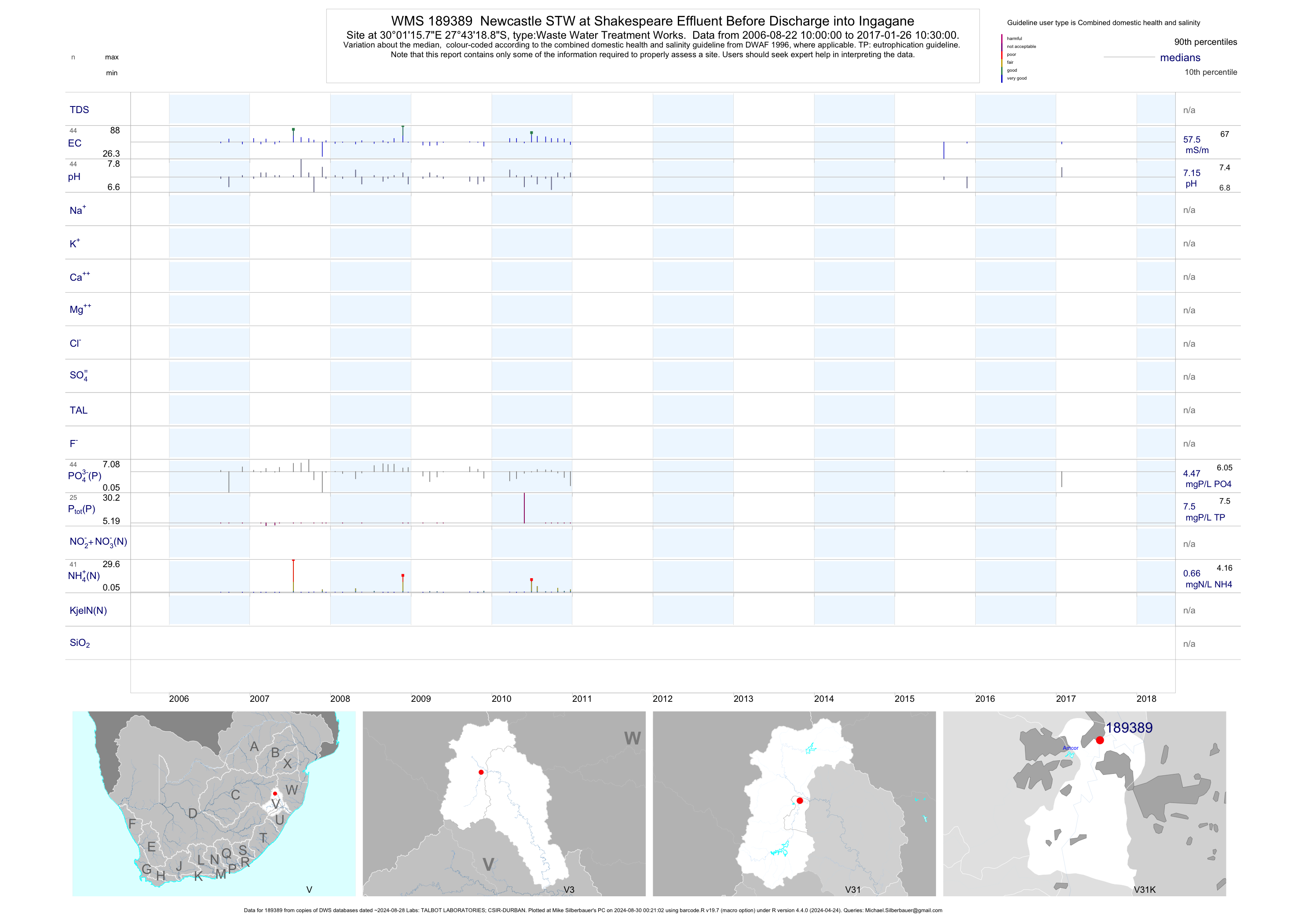
| V31 189389 | plot | data | Newcastle STW at Shakespeare Effluent Before Discharge into Ingagane | Waste Water Treatment Works | 47 | 2006-08-22 | 2017-01-26 | 58 | 189389 | -27.72192 | 30.02106 |
| V31 191871 | n/a | n/a | Vukuzakhe Sewage Works Final Effluent | Waste Water Treatment Works | 2 | 2015-07-28 | 2015-08-26 | n/a | 191871 | -27.38397 | 29.89361 |
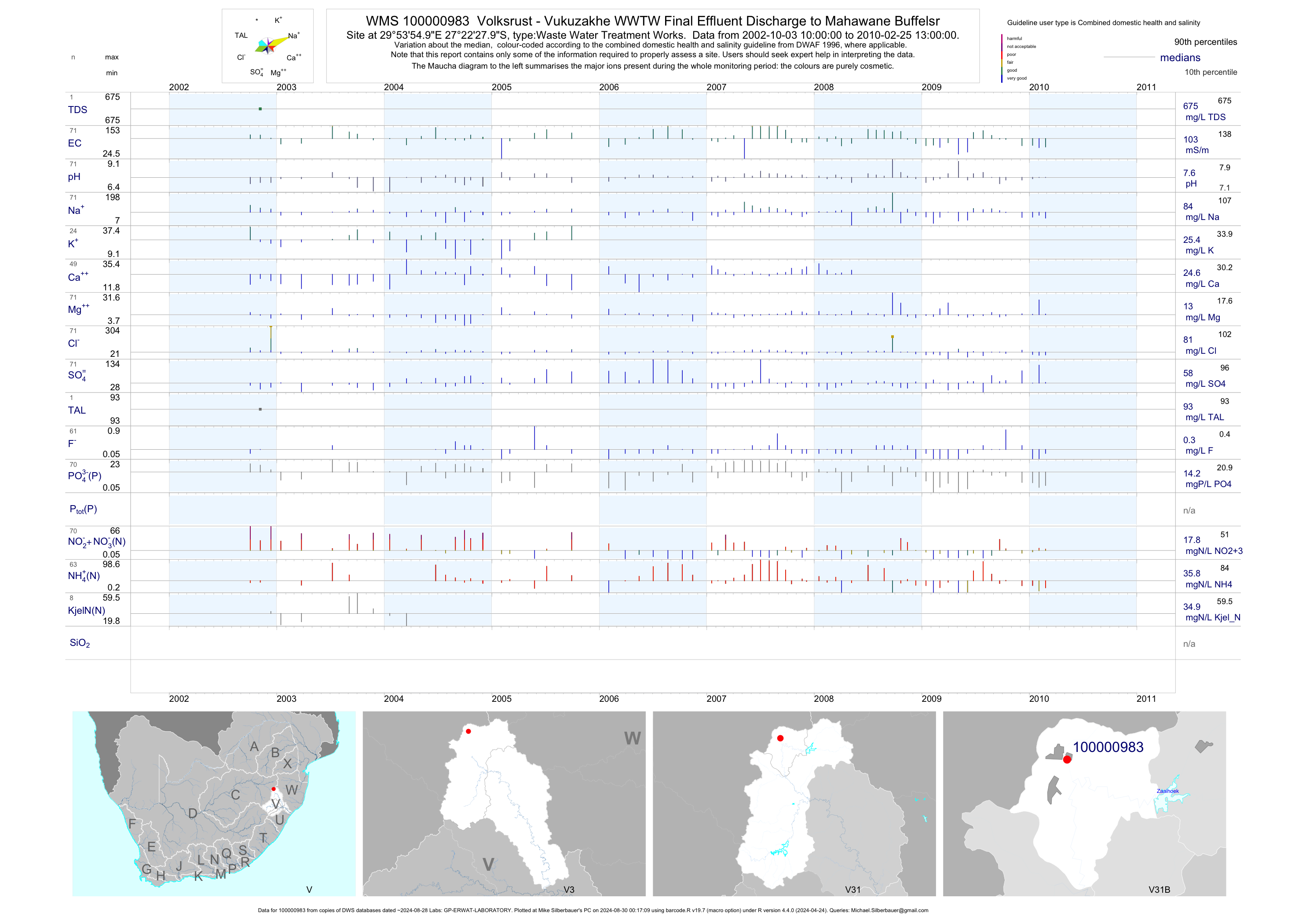
| V31 100000983 | plot | data | Volksrust - Vukuzakhe WWTW Final Effluent Discharge to Mahawane Buffelsr | Waste Water Treatment Works | 141 | 2002-10-02 | 2010-07-29 | 103 | 1-983 | -27.37444 | 29.89861 |
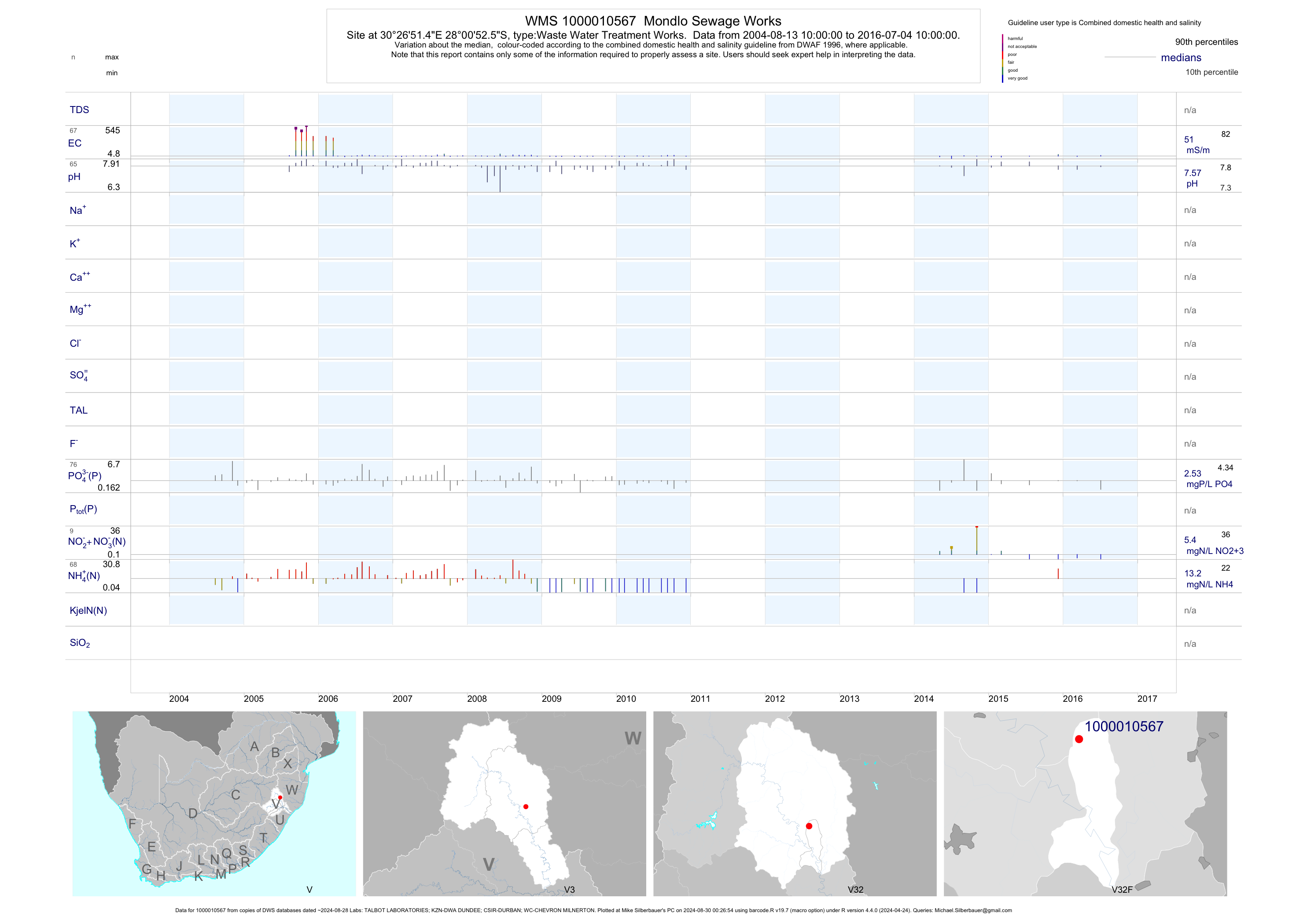
| V32 1000010567 | plot | data | Mondlo Sewage Works | Waste Water Treatment Works | 137 | 2004-08-12 | 2016-12-07 | 52 | 1-10567 | -28.01459 | 30.44763 |
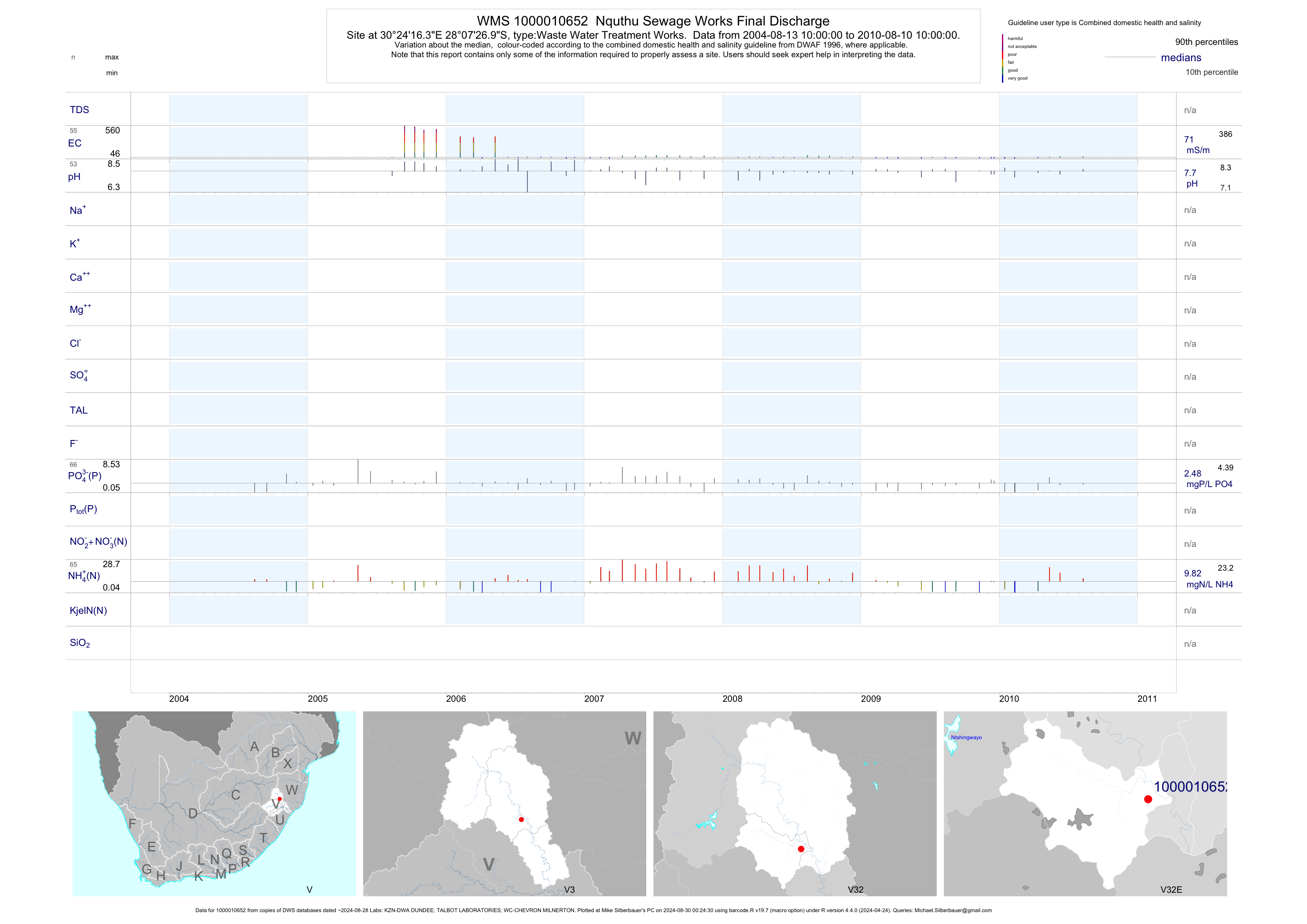
| V32 1000010652 | plot | data | Nquthu Sewage Works Final Discharge | Waste Water Treatment Works | 119 | 2004-08-12 | 2010-08-10 | 71 | 1-10652 | -28.12414 | 30.40455 |
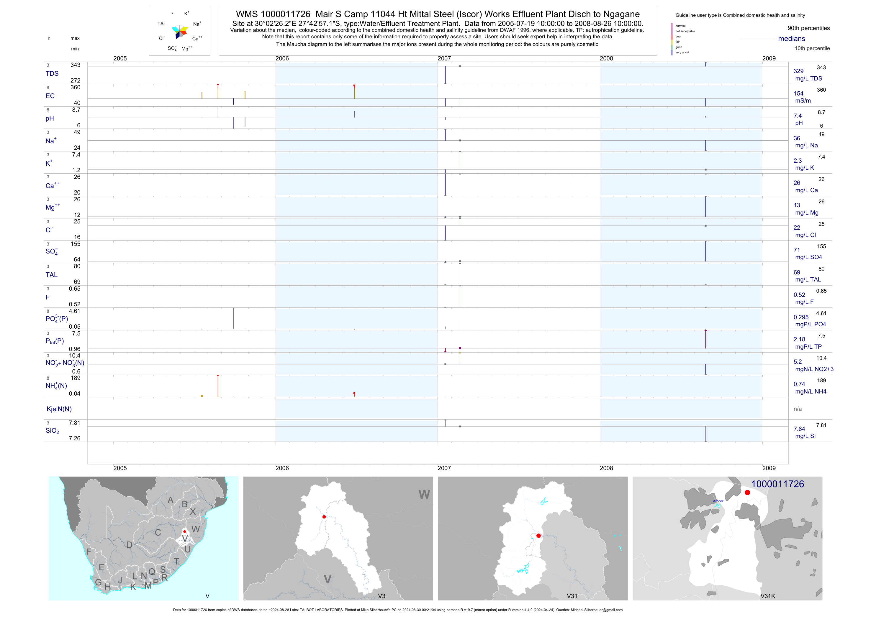
| V31 1000011726 | plot | data | Mair S Camp 11044 Ht Mittal Steel (Iscor) Works Effluent Plant Disch to Ngagane | Water/Effluent Treatment Plant | 13 | 2005-07-19 | 2008-08-26 | 154 | 1-11726 | -27.71588 | 30.04062 |
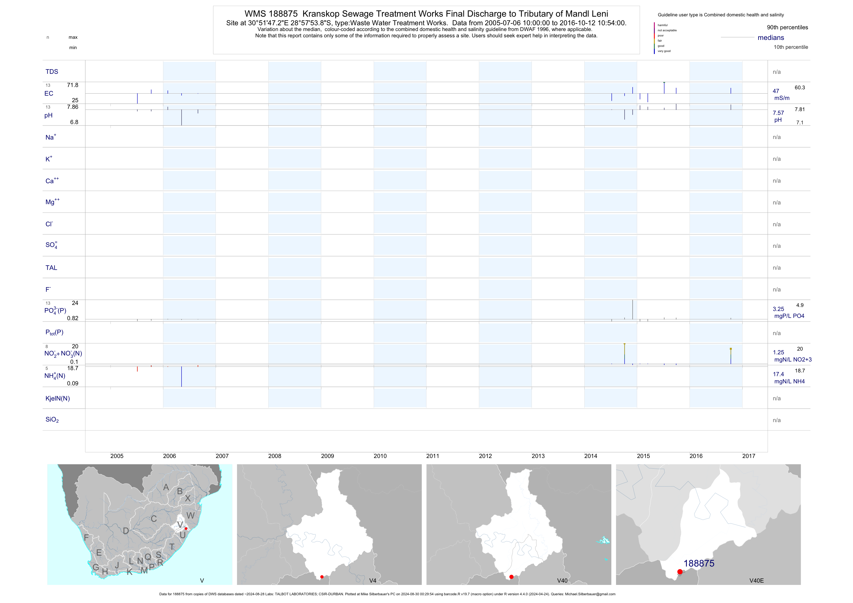
| V40 188875 | plot | data | Kranskop Sewage Treatment Works Final Discharge to Tributary of Mandl Leni | Waste Water Treatment Works | 28 | 2005-07-06 | 2017-02-21 | 47 | 188875 | -28.96497 | 30.86311 |
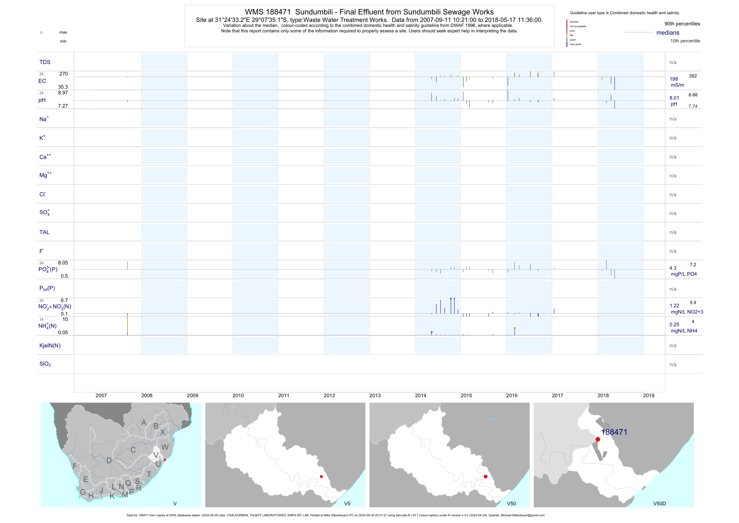
| V50 188471 | plot | data | Sundumbili - Final Effluent from Sundumbili Sewage Works | Waste Water Treatment Works | 58 | 2005-08-11 | 2018-05-17 | 198 | 188471 | -29.12642 | 31.40924 |
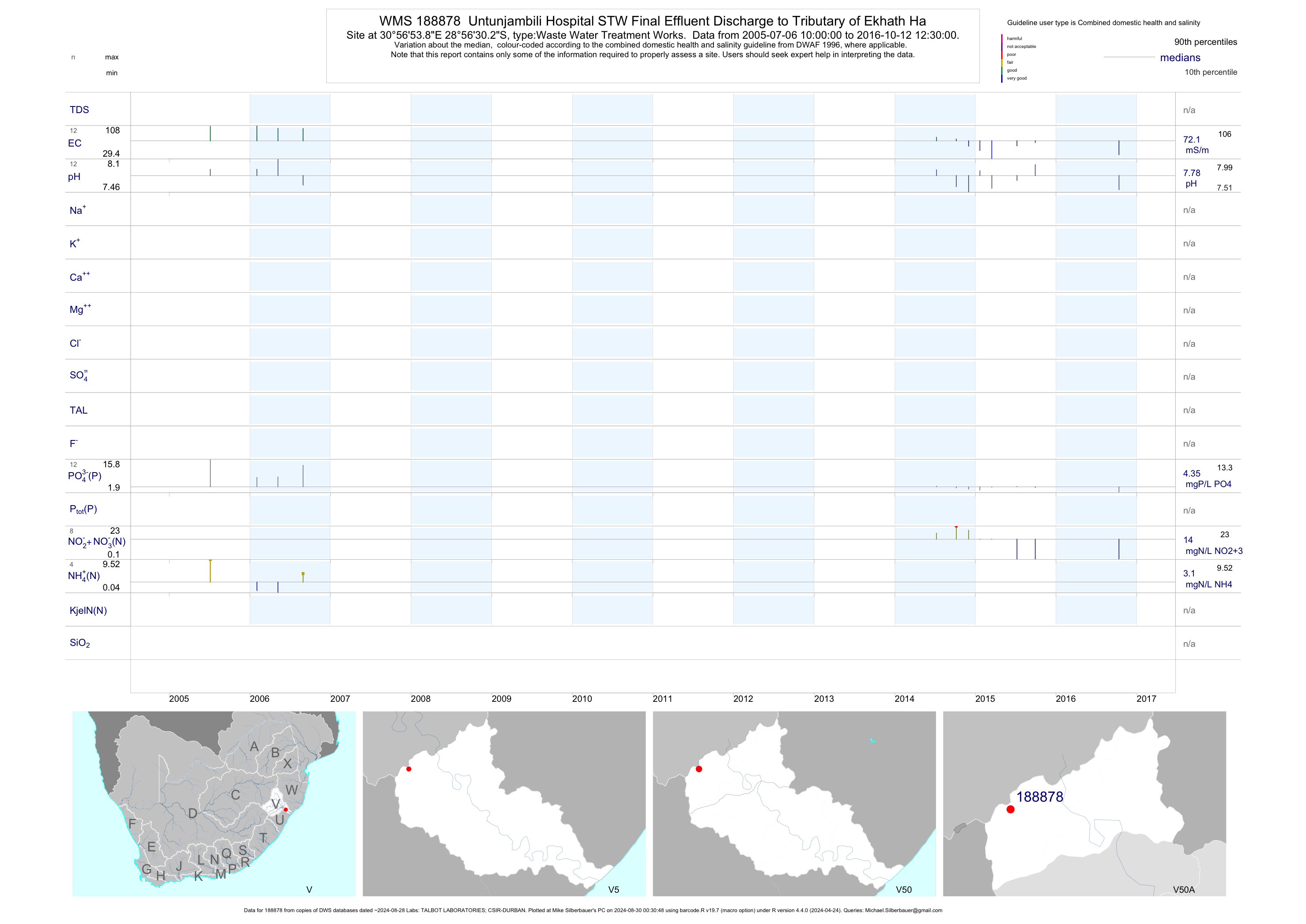
| V50 188878 | plot | data | Untunjambili Hospital STW Final Effluent Discharge to Tributary of Ekhath Ha | Waste Water Treatment Works | 26 | 2005-07-06 | 2017-02-21 | 72 | 188878 | -28.94172 | 30.94831 |
| V60 189045 | plot | data | Valkenburg Northfield Prison Final Effluent | Waste Water Treatment Works | 45 | 2006-03-27 | 2014-12-04 | 58 | 189045 | -28.14550 | 30.12669 |
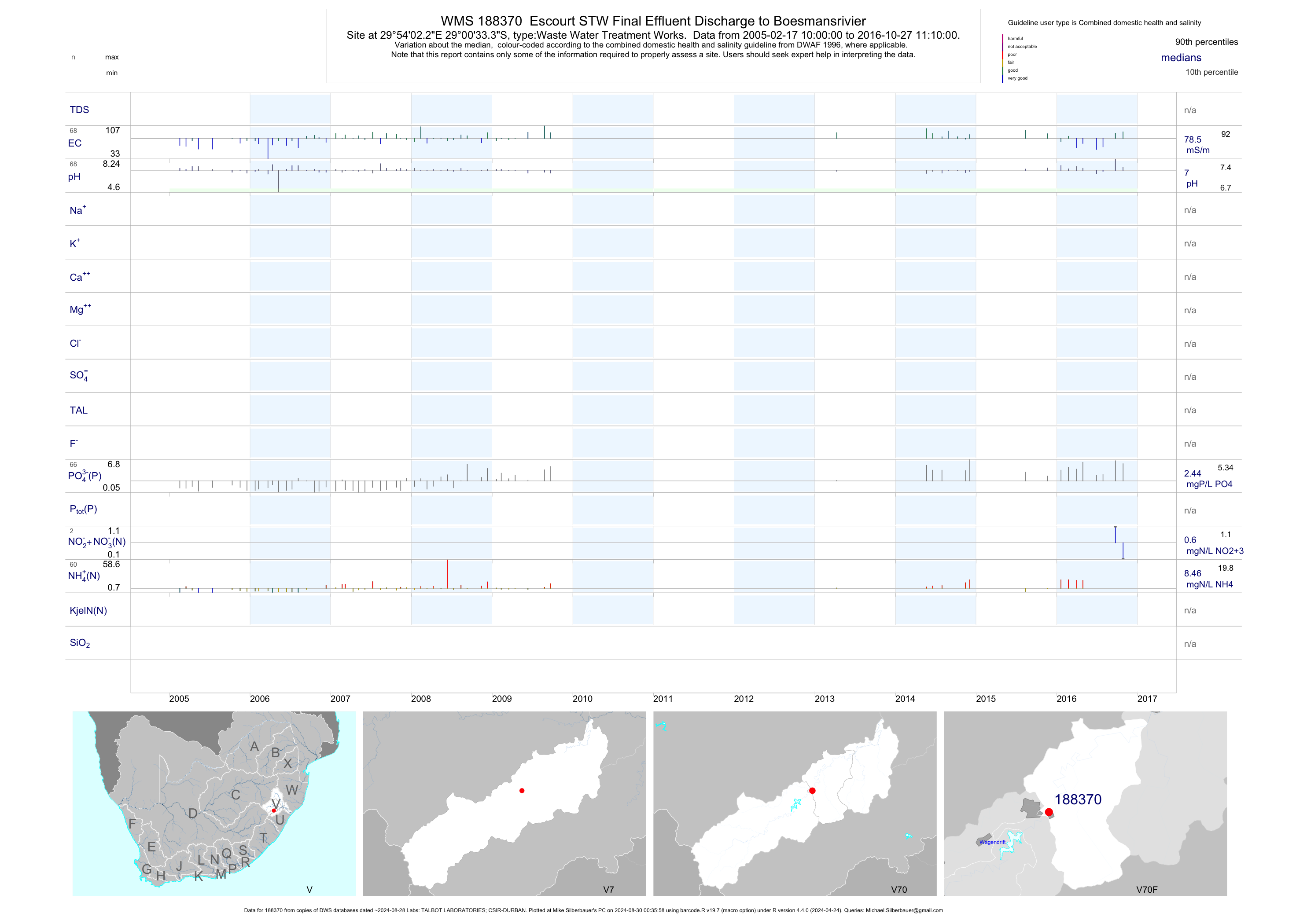
| V70 188370 | plot | data | Escourt STW Final Effluent Discharge to Boesmansrivier | Waste Water Treatment Works | 99 | 2005-02-17 | 2016-10-27 | 78 | 188370 | -29.00925 | 29.90061 |
| V70 189763 | plot | data | Craig 15988 Wembezi WWTW - Final Discharge to Klein Boesmansrivier Tributary | Waste Water Treatment Works | 2 | 2015-08-12 | 2015-08-12 | 25 | 189763 | -29.03483 | 29.77778 |
| V31 188951 | plot | data | Newcastle Township Karbochemspruit U/S of Confluence with Ngagane | Industrial Property | 58 | 2006-06-22 | 2016-06-30 | 51 | 188951 | -27.78403 | 29.99061 |
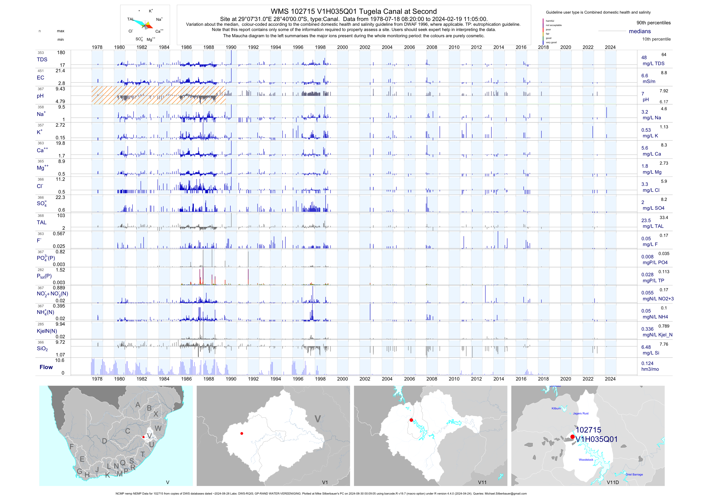
| V11 102715 | plot | data | Tugela Canal at Second (NCMP nemp NEMP) | Canal | 449 | 1978-07-18 | 2018-04-18 | 7 | V1H035 | -28.66667 | 29.12528 |
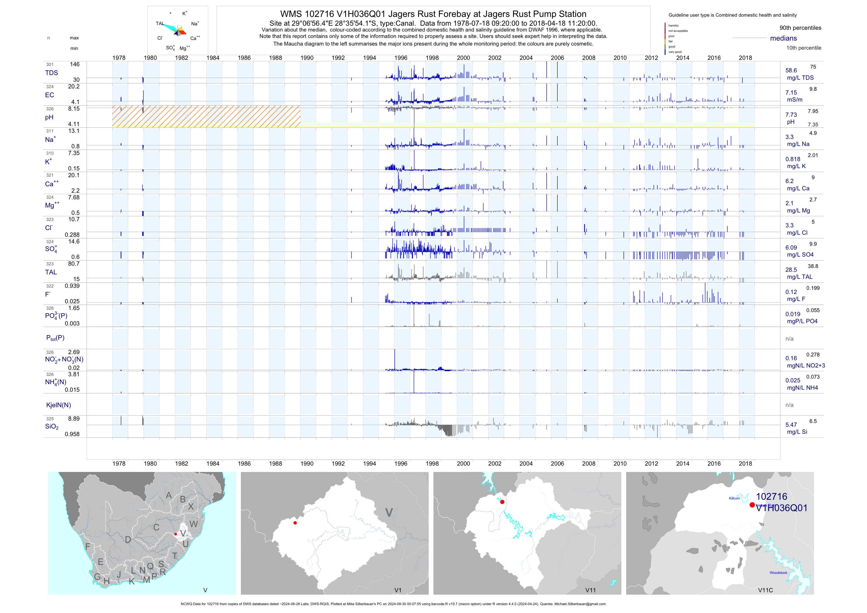
| V11 102716 | plot | data | Jagers Rust Forebay at Jagers Rust Pump Station (NCWQ) | Canal | 326 | 1978-07-18 | 2018-04-18 | 7 | V1H036 | -28.59839 | 29.11569 |
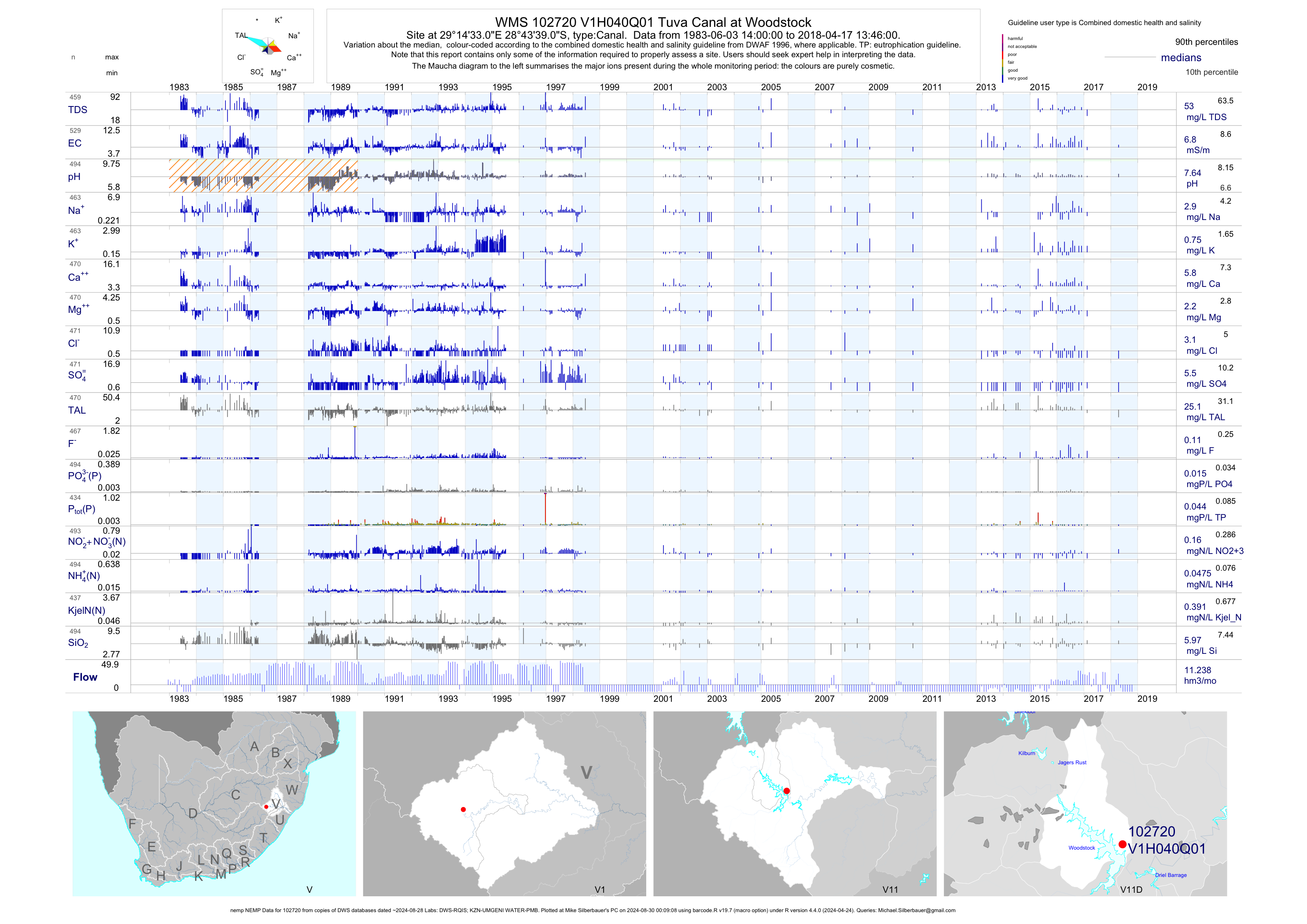
| V11 102720 | plot | data | Tuva Canal at Woodstock (nemp NEMP) | Canal | 531 | 1983-06-03 | 2018-04-17 | 7 | V1H040 | -28.72750 | 29.24250 |
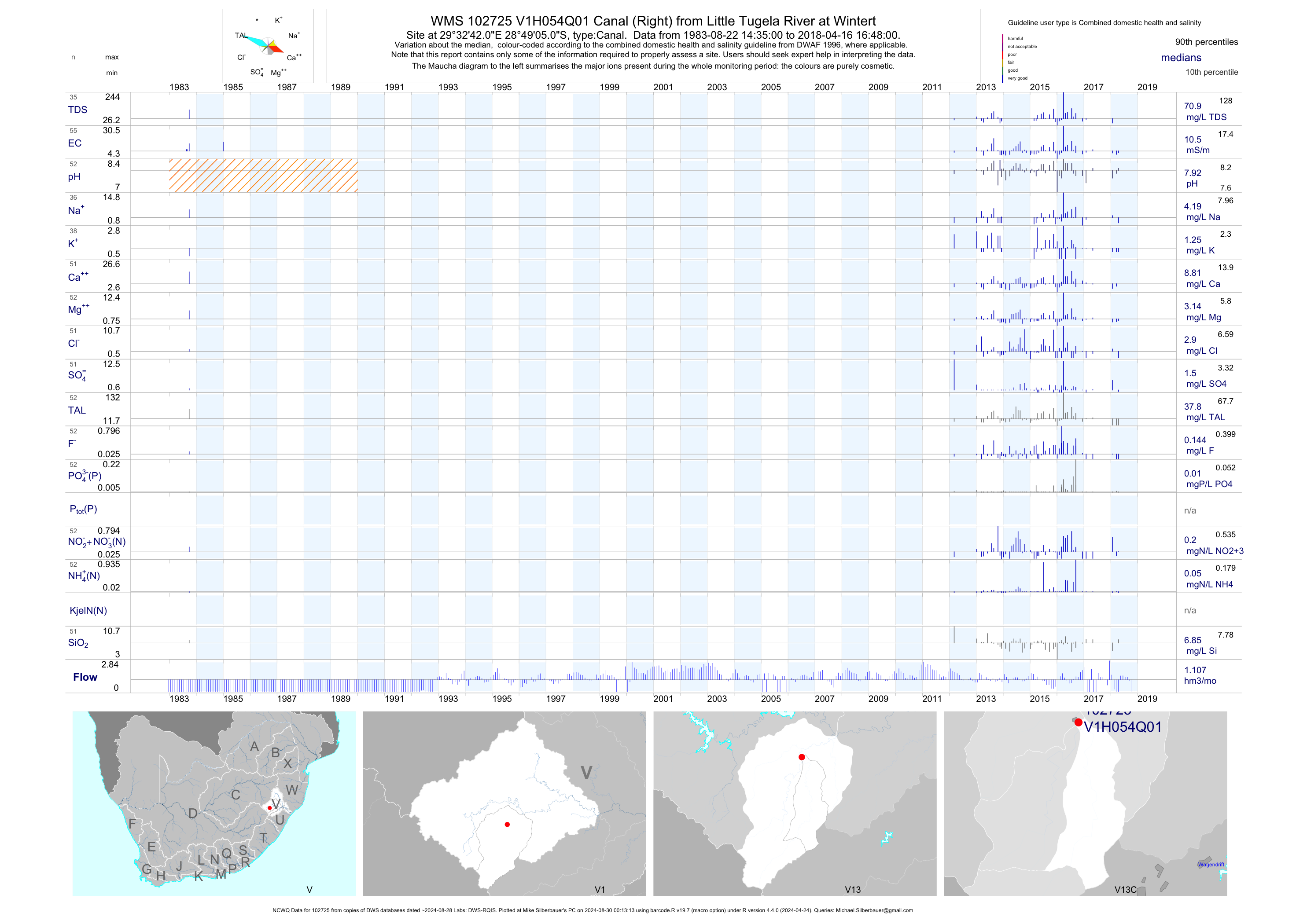
| V13 102725 | plot | data | Canal (Right) from Little Tugela River at Wintert (NCWQ) | Canal | 55 | 1983-08-22 | 2018-04-16 | 11 | V1H054 | -28.81806 | 29.54500 |
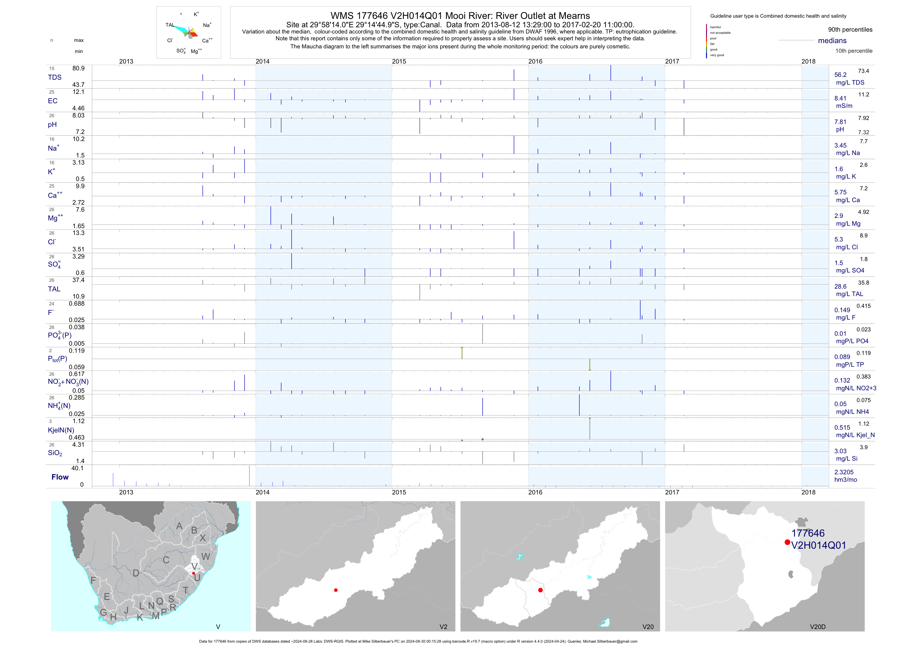
| V20 177646 | plot | data | Mooi River: River Outlet at Mearns | Canal | 27 | 2013-08-12 | 2017-02-20 | 8 | V2H014 | -29.24583 | 29.97056 |
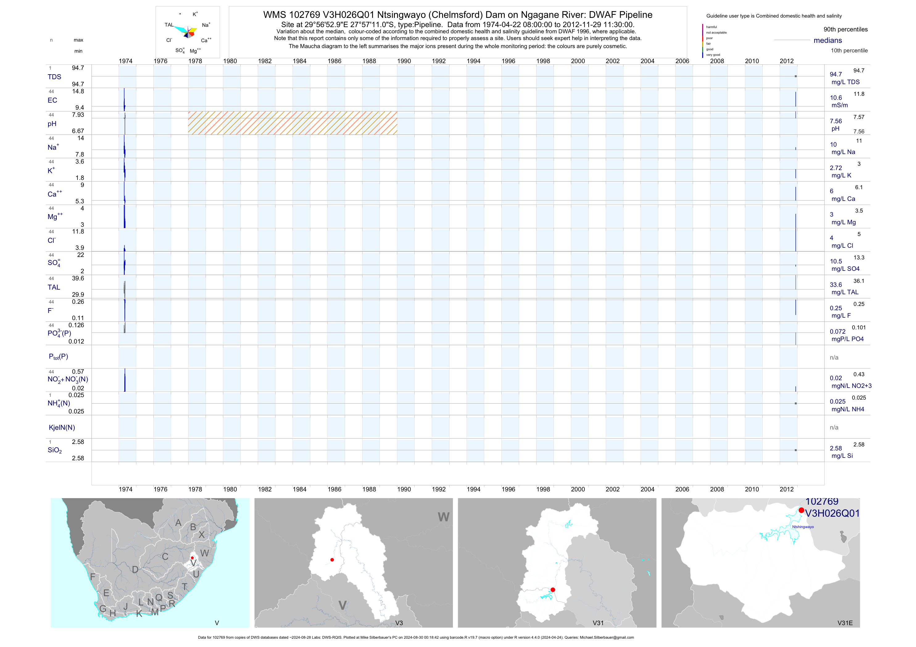
| V31 102769 | plot | data | Ntsingwayo (Chelmsford) Dam on Ngagane River: DWAF Pipeline | Pipeline | 44 | 1974-04-22 | 2012-11-29 | 11 | V3H026 | -27.95306 | 29.94806 |
| V31 188954 | plot | data | Newcastle Township Karbochem upstream Reference | Canal | 53 | 2006-06-22 | 2016-02-29 | 26 | 188954 | -27.79064 | 29.97050 |
| V31 191874 | n/a | n/a | Georgia Gardens Sewage Works Final Effluent at Georgia Gardens Sewage Works Final Effluent Canal | Canal | 2 | 2015-07-28 | 2015-08-26 | n/a | 191874 | -27.37511 | 29.89961 |
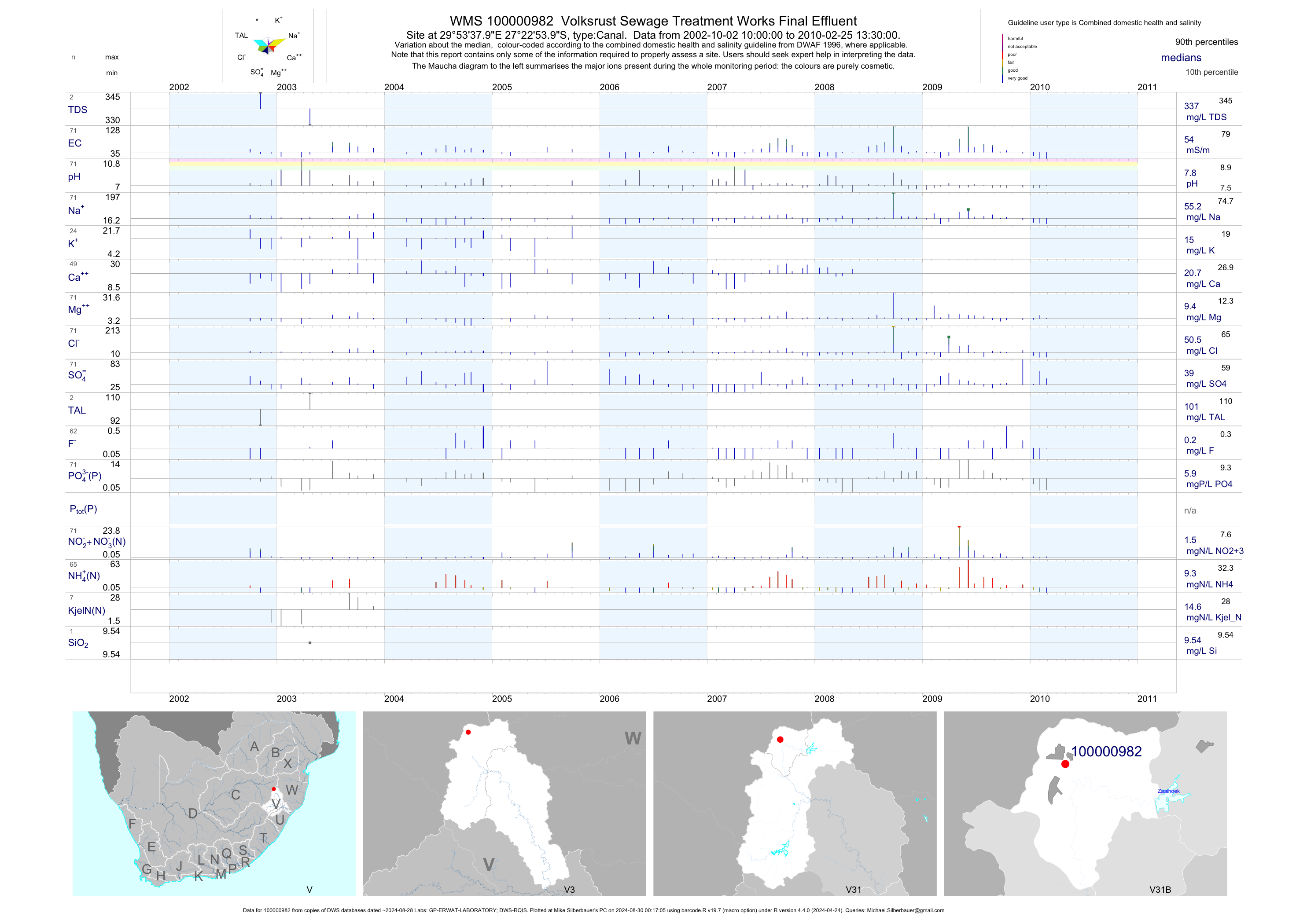
| V31 100000982 | plot | data | Volksrust Sewage Treatment Works Final Effluent | Canal | 140 | 2002-10-02 | 2010-07-29 | 54 | 1-982 | -27.38167 | 29.89389 |
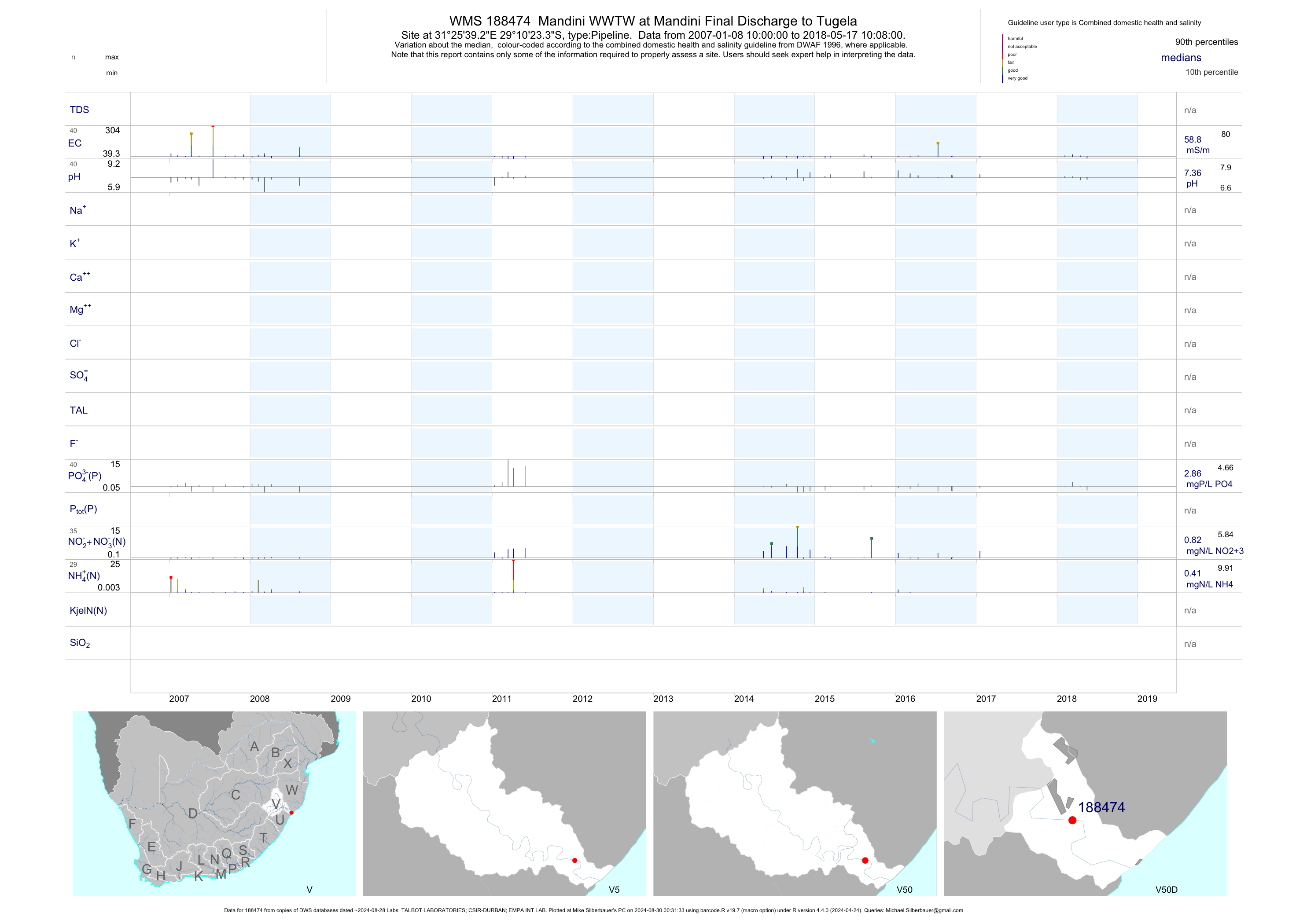
| V50 188474 | plot | data | Mandini WWTW at Mandini Final Discharge to Tugela | Pipeline | 79 | 2007-01-08 | 2018-05-17 | 59 | 188474 | -29.17317 | 31.42757 |
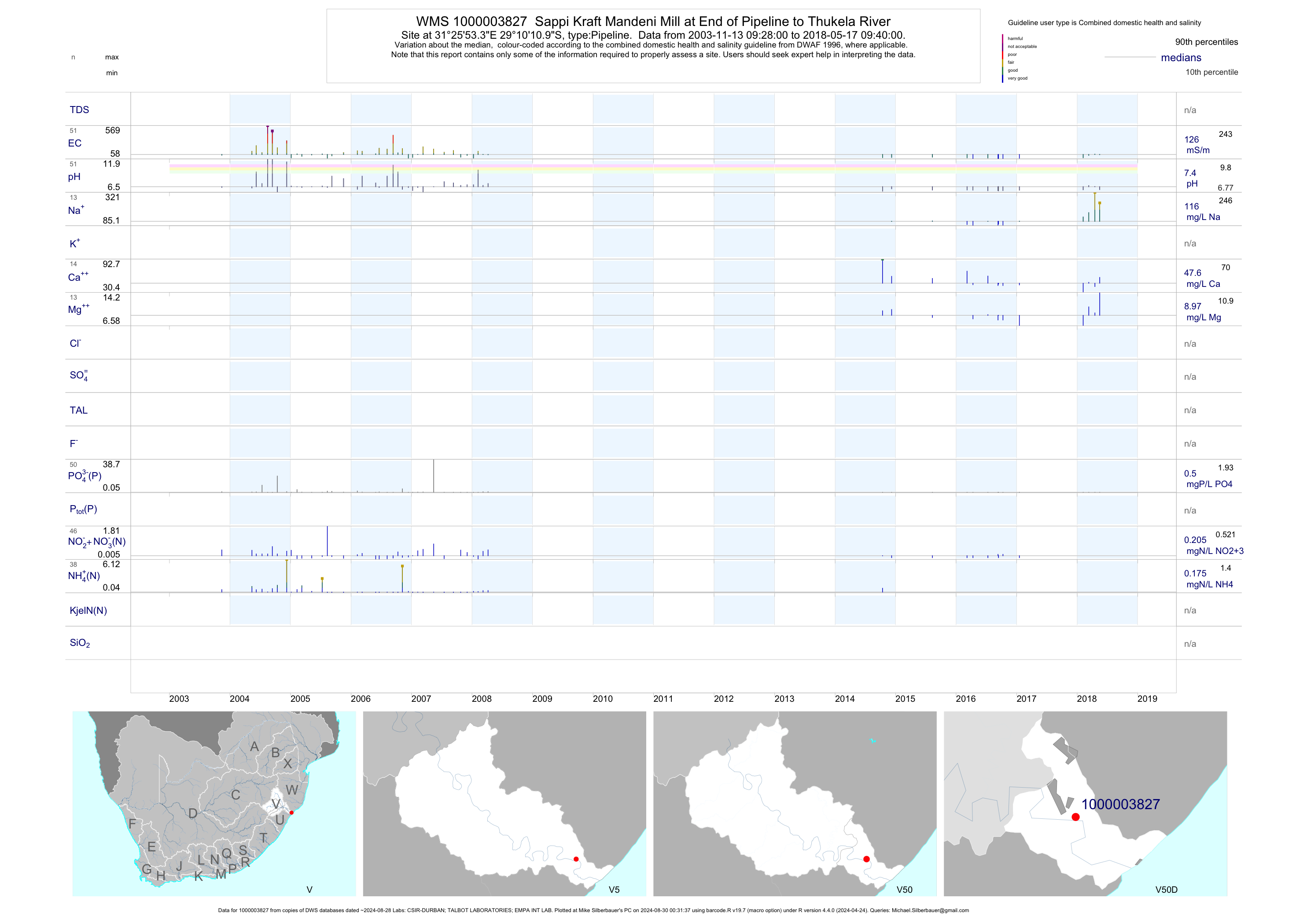
| V50 1000003827 | plot | data | Sappi Kraft Mandeni Mill at End of Pipeline to Thukela River | Pipeline | 73 | 2003-11-13 | 2018-05-17 | 128 | 1-3827 | -29.16972 | 31.43148 |
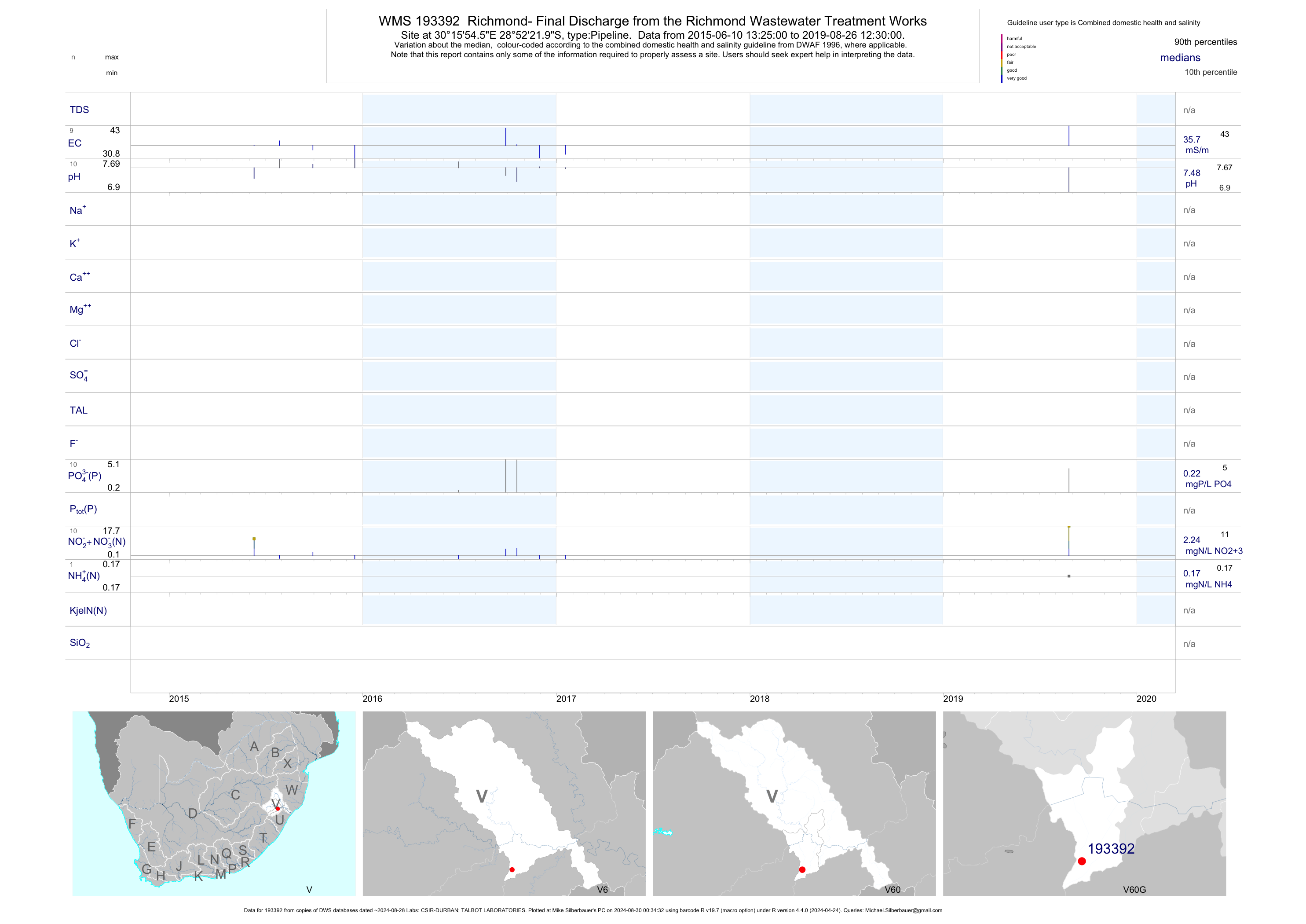
| V60 193392 | plot | data | Richmond- Final Discharge from the Richmond Wastewater Treatment Works | Pipeline | 19 | 2015-06-10 | 2017-01-18 | 35 | 193392 | -28.87278 | 30.26516 |
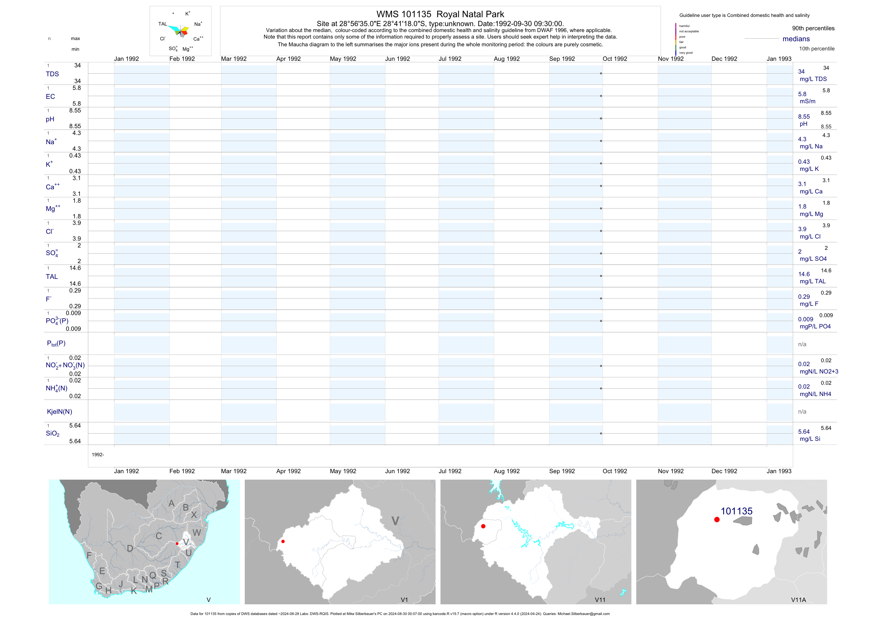
| V11 101135 | plot | data | Royal Natal Park | unknown | 1 | 1992-09-30 | 1992-09-30 | 6 | 101135 | -28.68833 | 28.94306 |
| V11 101393 | plot | data | Doornhoek (dup name 6899) | unknown | 1 | 1995-01-18 | 1995-01-18 | 3 | 101393 | -28.49889 | 29.42889 |
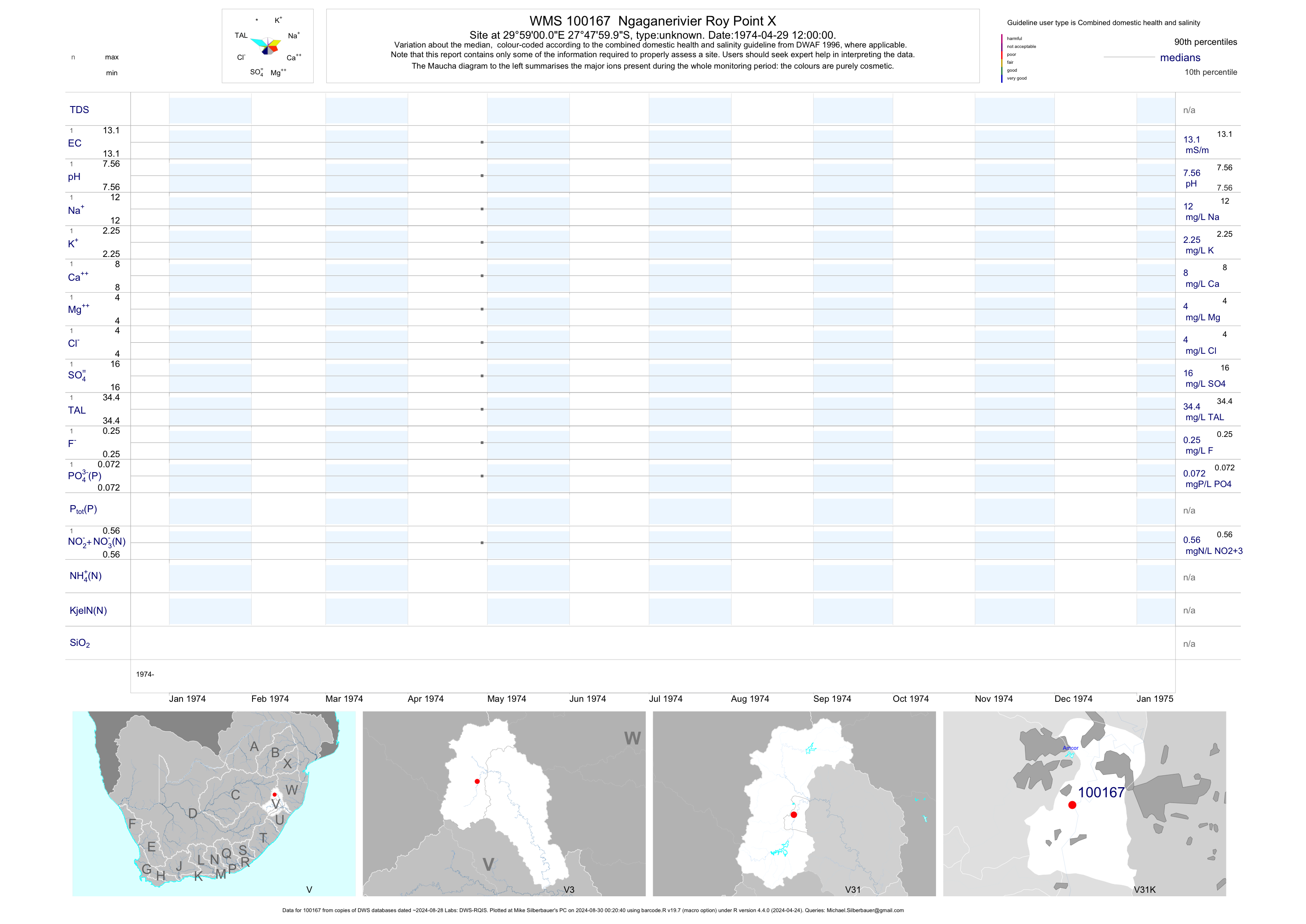
| V31 100167 | plot | data | Ngaganerivier Roy Point X | unknown | 1 | 1974-04-29 | 1974-04-29 | 13 | 100167 | -27.80000 | 29.98333 |
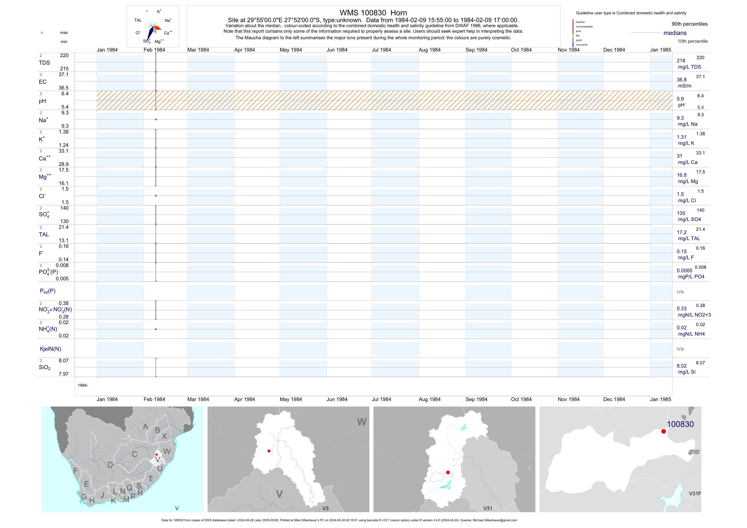
| V31 100830 | plot | data | Horn | unknown | 2 | 1984-02-09 | 1984-02-09 | 37 | 100830 | -27.86667 | 29.91667 |
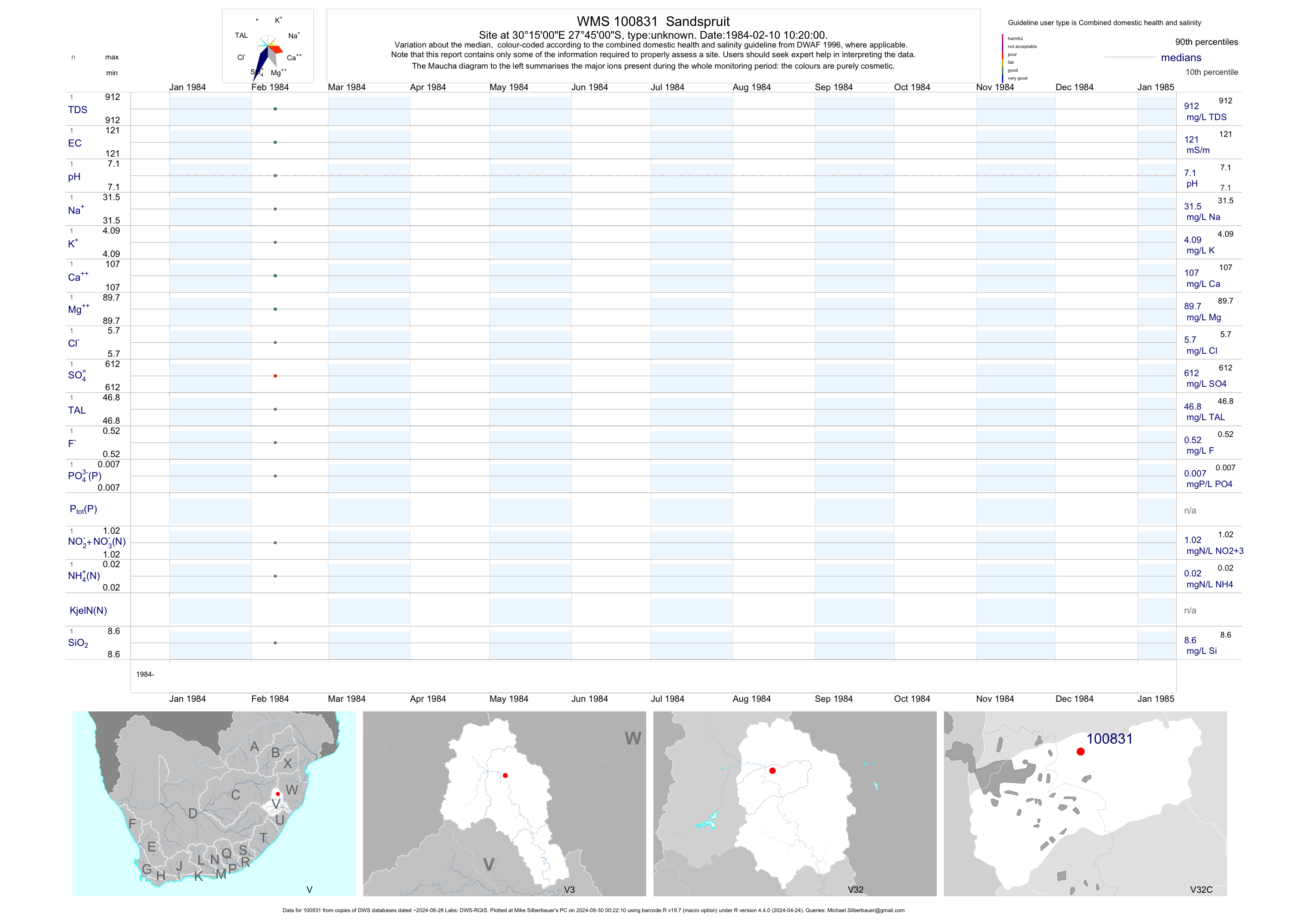
| V32 100831 | plot | data | Sandspruit | unknown | 1 | 1984-02-10 | 1984-02-10 | 121 | 100831 | -27.75000 | 30.25000 |
| V40 101415 | plot | data | Ntloshane Subward (dup name 6921) | unknown | 1 | 1995-08-29 | 1995-08-29 | 83 | 101415 | -28.72111 | 30.70278 |
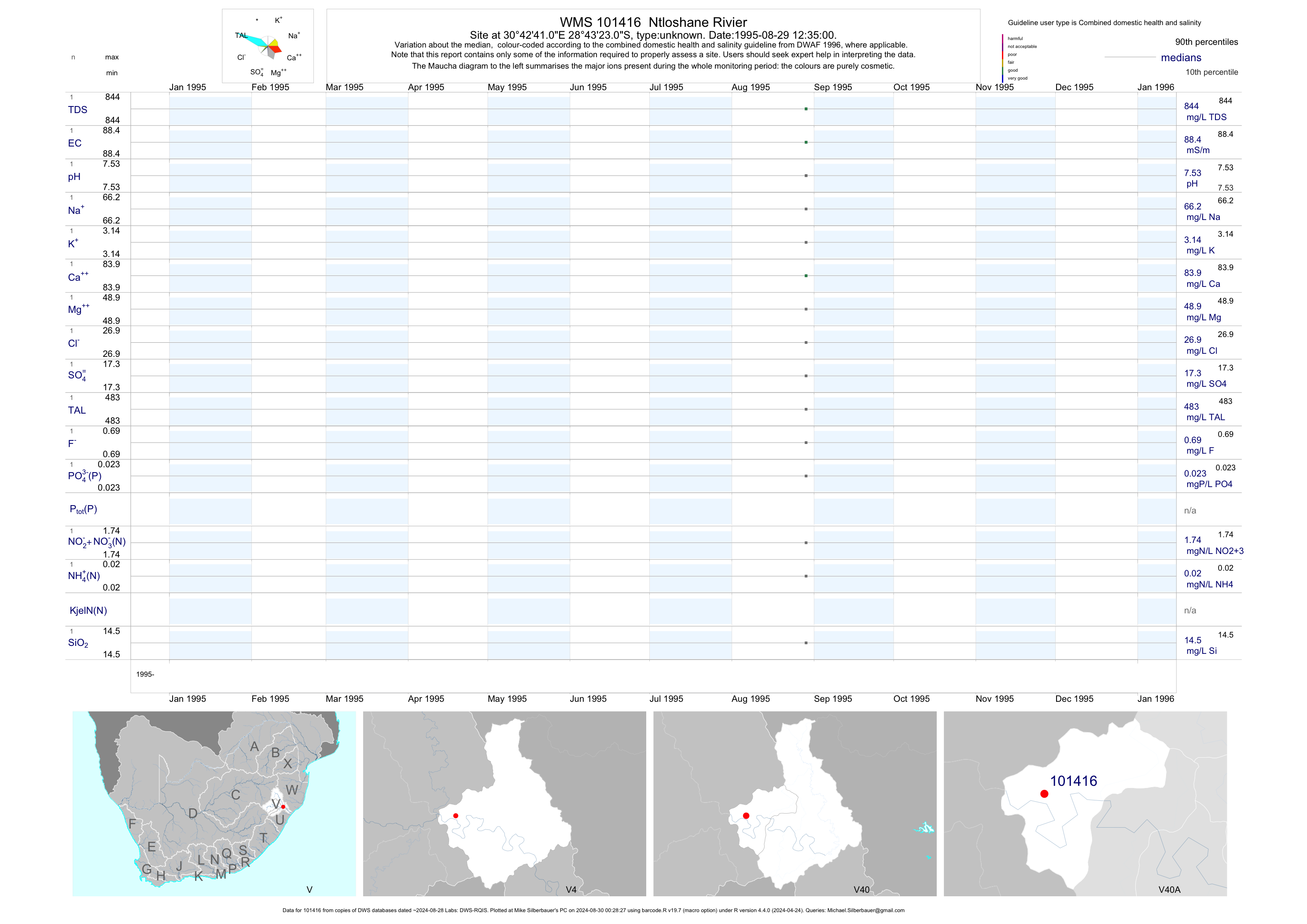
| V40 101416 | plot | data | Ntloshane Rivier | unknown | 1 | 1995-08-29 | 1995-08-29 | 88 | 101416 | -28.72306 | 30.71139 |
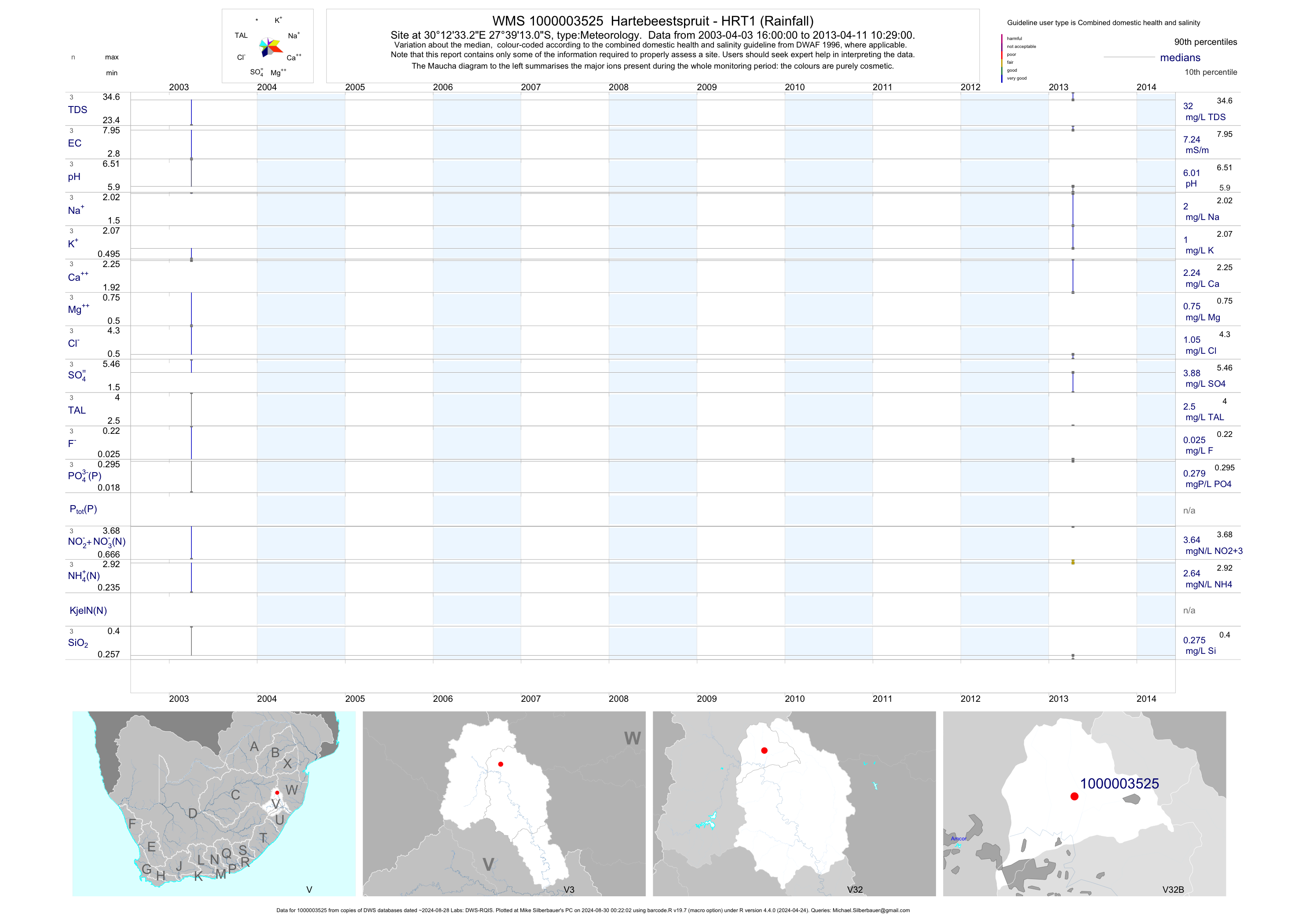
| V32 1000003525 | plot | data | Hartebeestspruit - HRT1 (Rainfall) | Meteorology | 3 | 2003-04-03 | 2013-04-11 | 7 | 1-3525 | -27.65364 | 30.20922 |
| V32 1000010323 | plot | data | Dundee ptn Craigic Burn - Dund (Rainfall) | Meteorology | 4 | 2004-10-25 | 2013-04-11 | 5 | 1-10323 | -28.14144 | 30.20811 |