Resource water quality data for Berg WMA.

Resource water quality data for Berg WMA. |
|
| Water quality | Description | Type | n | First date | Last date | med EC | Flow, if any |
Latitude | Longitude | ||
|---|---|---|---|---|---|---|---|---|---|---|---|
| G10 190790 | plot | data | - CMNT-Berg River-Berg G Vlaminke Vlei 54 - at R27 Road Bridge (Carinusbrug) on Groot- Bergrivie | Rivers | 14 | 2007-10-11 | 2013-11-12 | 804 | BE02 | -32.78704 | 18.16828 |
| G10 101932 | plot | data | -G1H024Q01 Kliphoek at Sishen/Saldanha Railway Bridge on Berg River (NCWQ) | Rivers | 346 | 1972-03-15 | 2018-03-06 | 1966 | BE03 | -32.81667 | 18.19417 |
| G10 190785 | plot | data | CMNT-Berg River-Berg a Klip Fontein 709 - at R315 Road Bridge on Groenrivier | Rivers | 5 | 2007-10-11 | 2009-11-12 | 170 | BERG A | -33.43900 | 18.53984 |
| G10 190786 | plot | data | CMNT-Berg River-Berg B Lelie Bloem 536 - at R307 Road Bridge on Groenrivier | Rivers | 9 | 2007-10-11 | 2013-11-12 | 519 | BERG B | -33.29156 | 18.44221 |
| G10 190787 | plot | data | CMNT-Berg River-Berg C Vogelstruisfontein 433 - at R307 Road Bridge on Soutrivier | Rivers | 8 | 2007-10-11 | 2013-11-12 | 1280 | BERG C | -33.21771 | 18.49122 |
| G10 190788 | plot | data | CMNT-Berg River-Berg D Schafplaatsfontein 345 - at R45 Road Bridge on Tributary of Soutrivier | Rivers | 14 | 2007-10-11 | 2013-11-12 | 2980 | BERG D | -33.11147 | 18.43217 |
| G10 190789 | plot | data | CMNT-Berg River-Berg E Hopefield - at R45 Road Bridge on Soutrivier | Rivers | 14 | 2007-10-11 | 2013-11-12 | 1768 | BERG E | -33.05751 | 18.34720 |
| G10 190797 | plot | data | CMNT-Berg River-Berg F Kersfontein 129 - at Kersfontein Bridge on Groot-Berg River | Rivers | 11 | 2007-10-11 | 2013-02-07 | 116 | BERG F | -32.90702 | 18.33444 |
| G10 190792 | plot | data | CMNT-Berg River-Berg H Zuurfontein 139 - at R399 Road Bridge on Boesmansrivier | Rivers | 10 | 2007-10-11 | 2013-11-12 | 33 | BERG H | -32.84406 | 18.56731 |
| G10 101914 | plot | data | At le Mouillage la Motte on Franschhoekrivier (NCWQ) | Rivers | 852 | 1966-01-06 | 2010-10-07 | 14 | G1H003 | -33.89056 | 19.07889 |
| G10 187096 | plot | data | Upstream of Robertsvlei on Berg River | Rivers | 40 | 2003-04-03 | 2007-07-26 | 4 | G1H004 | -33.94833 | 19.07556 |
| G10 187097 | plot | data | Downstream of Skuifraam on Berg River | Rivers | 39 | 2003-05-01 | 2007-08-09 | 5 | G1H004 | -33.90278 | 19.05500 |
| G10 101915 | plot | data | At Berg Rivershoek Driefontein on Berg River (NCWQ) | Rivers | 962 | 1965-08-23 | 2010-10-07 | 5 | G1H004 | -33.92667 | 19.06139 |
| G10 101916 | plot | data | at Farm 187 Katryntjiesdrif Wellington on Berg River | Rivers | 79 | 1965-09-01 | 2012-04-11 | 14 | G1H007 | -33.64214 | 18.98364 |
| G10 101917 | plot | data | Nieuwkloof 198 - on Klein Berg River (ncwq NCMP nemp NEMP) | Rivers | 1308 | 1955-08-27 | 2018-03-08 | 19 | G1H008 | -33.31389 | 19.07472 |
| G10 101918 | plot | data | At Knolvlei Forest Reserve on Brakkloof Tributary (NCWQ) | Rivers | 338 | 1971-08-20 | 2018-03-08 | 262 | G1H009 | -33.39111 | 19.17194 |
| G10 101919 | plot | data | Knolvlei Spruit at Knolvlei Forest Reserve (NCWQ) | Rivers | 169 | 1974-10-21 | 2017-10-26 | 30 | G1H010 | -33.39000 | 19.15972 |
| G10 101920 | plot | data | Watervals River at Watervalsberge/Upper Watervals | Rivers | 134 | 1977-10-18 | 2008-05-05 | 7 | G1H011 | -33.37889 | 19.10000 |
| G10 101921 | plot | data | Watervals River at Watervalsberge/Lower Watervals (NCWQ) | Rivers | 578 | 1977-10-18 | 2018-02-01 | 7 | G1H012 | -33.35222 | 19.10111 |
| G10 101922 | plot | data | At Drieheuvels on Berg River (ncwq NCMP nemp) | Rivers | 1555 | 1965-09-01 | 2018-01-31 | 24 | G1H013 | -33.13083 | 18.86278 |
| G10 101923 | plot | data | Zachariashoek River at Zachariashoek | Rivers | 52 | 1975-11-28 | 1995-10-05 | 6 | G1H014 | -33.82750 | 19.03556 |
| G10 101924 | plot | data | Kasteelskloof Spruit Upper at Zachariashoek | Rivers | 41 | 1983-08-04 | 1998-11-05 | 4 | G1H015 | -33.81528 | 19.06194 |
| G10 101925 | plot | data | Kasteelskloof Spruit Lower at Zachariashoek | Rivers | 55 | 1975-11-27 | 1990-06-05 | 4 | G1H016 | -33.82194 | 19.05972 |
| G10 101926 | plot | data | Zachariashoek Spruit Upper at Zachariashoek | Rivers | 45 | 1983-08-04 | 1998-09-17 | 6 | G1H017 | -33.82639 | 19.02861 |
| G10 101927 | plot | data | At Zachariashoek on Bakkerskloof | Rivers | 161 | 1981-09-10 | 1995-05-25 | 4 | G1H018 | -33.82250 | 19.04722 |
| G10 101928 | plot | data | At Jonkershoek the Sanctuary on Banghoekrivier (NCWQ) | Rivers | 1144 | 1974-09-17 | 2010-10-01 | 7 | G1H019 | -33.91222 | 18.94333 |
| G10 101929 | plot | data | At Dal Josafat Noorder Paarl on Berg River (ncwq NCMP) | Rivers | 1465 | 1965-08-25 | 2018-01-26 | 10 | G1H020 | -33.70750 | 18.97444 |
| G10 101930 | plot | data | Little Berg River at Mountain View (NCWQ) | Rivers | 482 | 1969-10-07 | 2018-03-08 | 4 | G1H021 | -33.18472 | 19.15528 |
| G10 101931 | plot | data | (BE06) - Jantjiesfontein 69 - at Berg River Town on Groot- Berg River (ncwq NCMP) | Rivers | 383 | 1971-07-29 | 2017-11-21 | 86 | G1H023 | -32.94583 | 18.33667 |
| G10 101933 | plot | data | Vier en Twintig River at Drie-Das-Bosch (NCWQ) | Rivers | 763 | 1972-03-14 | 2014-08-28 | 4 | G1H028 | -33.13389 | 19.06083 |
| G10 101934 | plot | data | Leeu River at de Hoek Estates (NCWQ) | Rivers | 603 | 1973-05-17 | 2014-10-02 | 5 | G1H029 | -33.15667 | 19.05222 |
| G10 101935 | plot | data | At Misverstand Die Brug on Berg River (ncwq NCMP nemp NEMP) | Rivers | 1574 | 1974-06-14 | 2017-10-25 | 35 | G1H031 | -32.99694 | 18.77889 |
| G10 101936 | plot | data | At Bosmanshoek on Banghoekrivier | Rivers | 51 | 1977-03-04 | 2002-04-18 | 3 | G1H032 | -33.95306 | 18.97889 |
| G10 101937 | plot | data | Moorreesburg Spruit at Holle River (NCWQ nemp NEMP) | Rivers | 1386 | 1972-06-28 | 2018-03-07 | 878 | G1H034 | -33.06611 | 18.75972 |
| G10 101938 | plot | data | At Matjiesfontein on Matjiesriver (NCWQ nemp NEMP) | Rivers | 849 | 1971-10-23 | 2017-09-20 | 304 | G1H035 | -33.04778 | 18.83278 |
| G10 101939 | plot | data | At Vleesbank Hermon Bridge on Berg River (ncwq NCMP nemp GEMS NEMP) | Rivers | 1127 | 1978-03-08 | 2018-06-28 | 21 | G1H036 | -33.43500 | 18.95694 |
| G10 101940 | plot | data | Krom River at Wellington | Rivers | 633 | 1979-04-17 | 1992-06-23 | 15 | G1H037 | -33.63500 | 19.00833 |
| G10 101941 | plot | data | Wolwekloof River at Franschhoek (Tunnel Inlet) (NCWQ) | Rivers | 762 | 1983-10-07 | 2017-01-25 | 3 | G1H038 | -33.94417 | 19.02750 |
| G10 101942 | plot | data | At Grensplaas Diepe Gat on Doringrivier (NCWQ) | Rivers | 575 | 1979-06-12 | 2018-02-28 | 458 | G1H039 | -33.54333 | 18.92250 |
| G10 101943 | plot | data | Vis River at la Fonteine (NCWQ) | Rivers | 537 | 1980-05-14 | 2017-08-24 | 185 | G1H040 | -33.35722 | 18.95694 |
| G10 101944 | plot | data | Kompanjies River at de Eikeboomen (NCWQ) | Rivers | 1042 | 1979-09-11 | 2018-03-01 | 24 | G1H041 | -33.47917 | 18.97806 |
| G10 101945 | plot | data | At Vrisgewaagd on Sandspruit (NCWQ) | Rivers | 485 | 1980-09-09 | 2016-09-28 | 848 | G1H043 | -33.16139 | 18.89306 |
| G10 101952 | plot | data | at Bosmanshoek Banghoek Compensation H2O + in Shaft | Rivers | 7 | 1999-03-11 | 1999-09-30 | 4 | G1H062 | -33.95278 | 18.97917 |
| G10 101953 | plot | data | at Bosmanshoek Compensation H2O on Banghoekrivier (NCWQ) | Rivers | 797 | 1983-10-07 | 2010-10-01 | 4 | G1H064 | -33.95278 | 18.97917 |
| G10 194005 | plot | data | Robertsvlei - Berg River Dam - on Berg River U/S of Berg River Dam (NCMP) | Rivers | 32 | 2014-08-28 | 2018-03-01 | 4 | G1H076 | -33.95578 | 19.07289 |
| G10 194006 | plot | data | Robertsvlei - Berg River Dam - on Berg River D/S of Berg River Dam (NCMP) | Rivers | 29 | 2014-08-28 | 2017-11-30 | 5 | G1H077 | -33.90494 | 19.05478 |
| G10 194007 | plot | data | Boschendal - Dwars River at Boschendal (NCMP) | Rivers | 35 | 2014-09-25 | 2018-03-01 | 14 | G1H078 | -33.87358 | 18.98214 |
| G10 194008 | plot | data | Wemmershoek - on Wemmershoek River at Wemmershoek Dam (NCMP) | Rivers | 29 | 2014-08-28 | 2017-10-26 | 7 | G1H080 | -33.85240 | 19.04252 |
| G10 100058 | plot | data | Mbr 008 - Sonkwasdrift - at Bridge on Berg River (GW1-029 nr 55171 Hwk) | Rivers | 17 | 1971-10-23 | 1976-07-19 | 28 | 100058 | -33.34167 | 18.97917 |
| G10 100060 | plot | data | Mbr 007 - Kleinberg River GW1-031 NR55/71 at Road Bridge | Rivers | 27 | 1971-10-23 | 1976-09-10 | 50 | 100060 | -33.21833 | 18.97472 |
| G10 100062 | plot | data | Berg River GW1-045 nr 55/7 Hwk at Bridge to Moravia Silos | Rivers | 35 | 1971-10-23 | 1975-10-22 | 45 | 100062 | -32.94056 | 18.69139 |
| G10 186984 | plot | data | Berg River Tributary Site 1 | Rivers | 21 | 2003-01-18 | 2005-11-15 | 4 | 186984 | -33.95867 | 19.06933 |
| G10 186985 | plot | data | Berg River Site 2 | Rivers | 24 | 2003-01-18 | 2005-11-15 | 5 | 186985 | -33.89350 | 19.05016 |
| G10 186986 | plot | data | Berg River Site 3 | Rivers | 2 | 2003-01-18 | 2003-01-18 | 9 | 186986 | -33.76967 | 18.97700 |
| G10 186987 | plot | data | Berg River Site 4 - D/S of G1H013Q01 Drieheuvels | Rivers | 24 | 2003-01-19 | 2005-11-15 | 22 | 186987 | -33.13000 | 18.85950 |
| G10 186988 | plot | data | Berg River Site 5 - D/S of G1H013Q01 Drieheuvels | Rivers | 21 | 2003-01-19 | 2005-11-15 | 22 | 186988 | -33.12500 | 18.85583 |
| G10 186989 | plot | data | Berg River Site 6 - D/S of G1R003Q01 Misverstand Dam | Rivers | 23 | 2003-01-19 | 2005-11-15 | 22 | 186989 | -33.01517 | 18.78500 |
| G10 187149 | plot | data | 50M D/S of Confluence with Stiebeuel River on Franschhoek River (nmmp) | Rivers | 677 | 2003-05-06 | 2013-07-09 | n/a | 187149 | -33.89889 | 19.09269 |
| G10 187153 | plot | data | Between Railway and Road Bridges at R45 on Dwars River (nmmp) | Rivers | 51 | 2003-05-06 | 2004-02-19 | n/a | 187153 | -33.86995 | 18.98361 |
| G10 187154 | plot | data | D/S of Paarl Sewage Works Discharge at Riviera Farm on Berg River (nmmp) | Rivers | 645 | 2003-05-06 | 2013-07-09 | n/a | 187154 | -33.67647 | 18.97639 |
| G10 187155 | plot | data | Mbr 014 - Tulbagh - at R46 Road Bridge on Klein-Berg River (nmmp) | Rivers | 552 | 2003-05-06 | 2013-07-09 | n/a | 187155 | -33.31058 | 19.10031 |
| G10 187156 | plot | data | Mbr 004 - Wellington - D/S of Wellington WWTW at R44 Florida Road Bridge (nmmp) | Rivers | 669 | 2003-05-06 | 2013-07-09 | n/a | 187156 | -33.65047 | 18.96783 |
| G10 187932 | plot | data | At Paarl downstream of WWTW + Informal Settlement on Berg (nmmp) | Rivers | 602 | 2004-01-08 | 2013-07-09 | n/a | 187932 | -33.66667 | 18.97889 |
| G10 190309 | plot | data | No 6 Schoenemakersfontein 486 Saron at Goedverwag Bridge on Berg River (nmmp) | Rivers | 590 | 2004-03-02 | 2013-07-09 | n/a | 190309 | -33.25614 | 18.95311 |
| G10 192775 | plot | data | Edelweizz-Brug at Breede River (Rawsonvillw/Worcester) | Rivers | 17 | 2013-04-24 | 2014-05-21 | 8 | 192775 | -33.39105 | 19.20065 |
| G10 192779 | plot | data | La Plaisante-Brug at Breede River (Ceres/Wolseley) | Rivers | 16 | 2013-04-24 | 2014-03-27 | 11 | 192779 | -33.26882 | 19.12366 |
| G10 192782 | plot | data | Riool Rivier at Breede River (Ceres Wolseley) | Rivers | 12 | 2013-01-22 | 2014-01-30 | 9 | 192782 | -33.27015 | 19.19107 |
| G10 192788 | plot | data | Eilandplaas at Dwars River (Ceres) | Rivers | 21 | 2013-01-22 | 2014-02-20 | 13 | 192788 | -33.22478 | 19.19097 |
| G10 192790 | plot | data | Oewerbrug_(Kiewietstr.) at Dwars River (Ceres) | Rivers | 22 | 2013-01-22 | 2014-02-20 | 13 | 192790 | -33.21624 | 19.18052 |
| G10 192791 | plot | data | Rioolplaas-Brug at Dwars River (Ceres) | Rivers | 25 | 2013-01-22 | 2014-05-21 | 29 | 192791 | -33.22961 | 19.18728 |
| G10 197563 | n/a | n/a | Lbr 001 - Misverstand - at Berg River at Misverstand Dam | Rivers | 10 | 2018-11-13 | 2019-05-14 | 42 | 197563 | -33.02341 | 18.78793 |
| G10 197564 | n/a | n/a | Lbr 002 - Bridgetown - at Berg River at Bridgetown | Rivers | 10 | 2018-11-13 | 2019-05-14 | 18 | 197564 | -33.10611 | 18.84108 |
| G10 197565 | n/a | n/a | Lbr 003 - Nuwedrif - at Berg River on Old N7 Road Bridge | Rivers | 10 | 2018-11-13 | 2019-05-14 | 47 | 197565 | -32.97177 | 18.74657 |
| G10 197566 | n/a | n/a | Lbr 004 - Moravia - Berg River at Moravia Low Laying Bridge | Rivers | 10 | 2018-11-13 | 2019-05-14 | 67 | 197566 | -32.92435 | 18.67740 |
| G22 200000766 | plot | data | CMNT-CCT-Above Confluence of Black and Liesbeek Rivers | Rivers | 120 | 1996-10-01 | 2013-11-18 | 114 | ABOVE C | -33.90820 | 18.47390 |
| G22 189732 | plot | data | CMNT-B0720A1 Spier 491 Stellenbosch at Wine Corp Spier on Bonterivier (See 1000010229) | Rivers | 29 | 2006-10-19 | 2013-12-12 | 47 | B0720A | -33.98348 | 18.78620 |
| G22 1000009373 | plot | data | CMNT-CCT-Big Lotus River into Zeekoeivlei | Rivers | 135 | 1996-08-06 | 2013-11-18 | 130 | BIG LOT | -34.04750 | 18.51880 |
| G22 1000010230 | plot | data | CMNT- Stellenbosch - BL720A - Blaauklippen Riv on de Kleine Zalze Farm | Rivers | 108 | 1996-04-14 | 2013-12-12 | 19 | BL720A | -33.97230 | 18.83430 |
| G22 1000010229 | plot | data | CMNT-BO720A Spier 491 Stellenbosch Die Vleie Farm on Bonterivier (See 189732) | Rivers | 62 | 1996-04-16 | 2006-11-30 | 45 | BO720A | -33.98330 | 18.78750 |
| G21 1000010204 | plot | data | CMNT-Diep+mb-Dr a-Diep at Paardeberg | Rivers | 36 | 1997-09-17 | 2012-08-29 | 187 | DR A | -33.47800 | 18.80190 |
| G21 1000010205 | plot | data | CMNT-Diep+mb-Dr B-Diep Above Malmesbury at Rustfontein | Rivers | 56 | 1997-09-17 | 2012-08-29 | 236 | DR B | -33.42950 | 18.75280 |
| G21 1000010206 | plot | data | CMNT-Diep+mb-Dr C-Diep in Malmesbury Town | Rivers | 59 | 1997-09-17 | 2012-08-29 | 236 | DR C | -33.46590 | 18.72990 |
| G21 1000010207 | plot | data | CMNT-Diep+mb-Dr D-Diep below Malmesbury WWTP | Rivers | 5 | 2004-07-21 | 2005-11-16 | 188 | DR D | -33.47630 | 18.70900 |
| G21 1000010209 | plot | data | CMNT-Diep+mb-Dr F-Diep at Kalbaskraal | Rivers | 77 | 1997-09-17 | 2012-08-29 | 237 | DR F | -33.57030 | 18.64090 |
| G21 1000010210 | plot | data | CMNT-Diep+mb-Dr G-Diep Above Mosselbank Confluence | Rivers | 64 | 1997-09-17 | 2012-08-29 | 255 | DR G | -33.67670 | 18.60650 |
| G21 1000010211 | plot | data | CMNT-Diep+mb-Dr H-Diep at Goedeontmoeting | Rivers | 66 | 1997-09-17 | 2012-08-29 | 239 | DR H | -33.68570 | 18.61290 |
| G21 1000010212 | plot | data | CMNT-Diep+mb-Dr I-Diep at N7 Bridge | Rivers | 76 | 1997-09-17 | 2012-08-29 | 290 | DR I | -33.79030 | 18.54810 |
| G21 1000010215 | plot | data | CMNT-Diep+mb-Dr J-Swart River at Groenrivier Station | Rivers | 43 | 1998-06-08 | 2012-08-29 | 126 | DR J | -33.55450 | 18.61580 |
| G21 1000010217 | plot | data | CMNT-Diep+mb-Dr K-Unnamed Trib to Diep ex Philadelphia-G21D | Rivers | 28 | 1999-08-03 | 2009-11-18 | 510 | DR K | -33.67710 | 18.60490 |
| G21 1000010218 | plot | data | CMNT-Diep+mb-Dr L-Diep at Tableview Bridge | Rivers | 145 | 1996-08-06 | 2012-08-29 | 205 | DR L | -33.83300 | 18.52200 |
| G21 1000010219 | plot | data | CMNT-Diep+mb-Dr M-Diep at Otto du Plessis Bridge | Rivers | 155 | 1996-08-06 | 2013-03-06 | 190 | DR M | -33.85830 | 18.49980 |
| G22 200000748 | plot | data | CMNT-CCT-Else River at Glencairn | Rivers | 135 | 1996-01-10 | 2013-11-18 | 80 | ELSE RI | -34.15950 | 18.43090 |
| G22 1000009582 | plot | data | CMNT-Stellenbosch-ER720A1- at Assegaaibos Bridge | Rivers | 152 | 1995-02-14 | 2013-12-12 | 6 | ER720A1 | -33.97280 | 18.93670 |
| G22 189733 | plot | data | CMNT-ER720B1 Stellenbosch at Die Boord Mall U/S Plankenbrug Confluence on Eersterivier | Rivers | 34 | 2006-10-19 | 2013-12-12 | 12 | ER720B | -33.94223 | 18.85051 |
| G22 1000009583 | plot | data | CMNT-Stellenbosch-ER720B - at Low-Water Drift Before Rugby Ground | Rivers | 37 | 2004-11-22 | 2013-12-12 | 8 | ER720B | -33.94140 | 18.89140 |
| G22 1000009584 | plot | data | CMNT-Stellenbosch-ER720C-at SFW Cricket Grounds | Rivers | 48 | 1990-05-15 | 2005-11-23 | 25 | ER720C | -33.94860 | 18.83860 |
| G22 1000009585 | plot | data | CMNT-Stellenbosch-ER720D-on Goedvertrouw Farm | Rivers | 227 | 1995-02-14 | 2013-12-12 | 40 | ER720D | -33.96080 | 18.81640 |
| G22 1000009586 | plot | data | CMNT- Stellenbosch - ER720E - Klein Welmoed at Frans se Weir | Rivers | 208 | 1995-02-14 | 2013-12-12 | 42 | ER720E | -34.00860 | 18.76140 |
| G22 1000009587 | plot | data | CMNT-Stellenbosch-ER720F-at Bridge to Macassar WWTW | Rivers | 198 | 1995-02-14 | 2013-12-12 | 75 | ER720F | -34.06250 | 18.74780 |
| G22 192947 | plot | data | Silvermine Dam Inflow - 3418AB | Rivers | 6 | 1988-09-06 | 2012-09-26 | 10 | G203/18A1 | -34.07361 | 18.39583 |
| G22 192948 | plot | data | Silvermine River Floodplain - 3418AB | Rivers | 6 | 1988-09-06 | 2012-09-26 | 34 | G203/19A1 | -34.12639 | 18.42861 |
| G22 101963 | plot | data | At Jonkershoek on Bosboukloof | Rivers | 86 | 1981-06-16 | 1996-11-21 | 8 | G2H002 | -33.96222 | 18.93111 |
| G22 101964 | plot | data | At Jonkershoek on Biesevlei | Rivers | 100 | 1983-08-03 | 1993-06-17 | 11 | G2H003 | -33.97250 | 18.94889 |
| G22 101965 | plot | data | Tierkloof River at Jonkershoek | Rivers | 70 | 1983-08-03 | 1993-06-17 | 6 | G2H004 | -33.97389 | 18.95167 |
| G22 101966 | plot | data | Kleinplaas Dam on Jonkershoek River: Down Stream (NCWQ) | Rivers | 767 | 1981-09-02 | 2018-02-09 | 8 | G2H005 | -33.97361 | 18.93806 |
| G22 101967 | plot | data | Abdolskloof River at Jonkershoek | Rivers | 45 | 1983-08-03 | 1995-04-04 | 11 | G2H006 | -33.96389 | 18.93611 |
| G22 101968 | plot | data | Lang River at Jonkershoek | Rivers | 81 | 1982-02-16 | 1996-10-15 | 4 | G2H007 | -33.98694 | 18.97028 |
| G22 101969 | plot | data | Jonkershoek River at Jonkershoek/Kleinplaas | Rivers | 558 | 1977-10-28 | 1994-10-06 | 4 | G2H008 | -33.98639 | 18.95639 |
| G22 101970 | plot | data | Lambrechtsbos Spruit Tributary at Jonkershoek | Rivers | 75 | 1983-08-03 | 1990-06-06 | 8 | G2H009 | -33.96389 | 18.94306 |
| G22 101971 | plot | data | Lambrechtsbos Spruit B at Jonkershoek | Rivers | 77 | 1983-08-03 | 1996-08-29 | 7 | G2H010 | -33.96806 | 18.94139 |
| G21 101972 | plot | data | Diep River at Malmesbury (ncwq NCMP) | Rivers | 703 | 1966-06-19 | 2019-05-14 | 230 | G2H012 | -33.46444 | 18.74056 |
| G21 101973 | plot | data | Mosselbank River at Klipheuwel | Rivers | 336 | 1966-07-04 | 1992-03-03 | 224 | G2H013 | -33.70500 | 18.70056 |
| G21 101974 | plot | data | At Vissershok on Dieprivier (ncwq) | Rivers | 315 | 1966-06-03 | 2005-05-23 | 333 | G2H014 | -33.78972 | 18.54944 |
| G22 101975 | plot | data | At Faure on Eerste River (ncwq NCMP) | Rivers | 833 | 1968-06-08 | 2018-02-28 | 46 | G2H015 | -34.03028 | 18.74833 |
| G22 101976 | plot | data | Lourens River at Somerset West | Rivers | 300 | 1970-08-10 | 1992-06-15 | 12 | G2H016 | -34.08694 | 18.85861 |
| G21 101977 | plot | data | Silwerstroom River at Buffels River | Rivers | 303 | 1974-11-23 | 1993-06-16 | 82 | G2H018 | -33.58194 | 18.36278 |
| G22 101978 | plot | data | At Stellenbosch on Eersterivier | Rivers | 136 | 1977-05-10 | 1982-05-05 | 24 | G2H019 | -33.94361 | 18.84417 |
| G22 101979 | plot | data | At Fleurbaai Stellenbosch on Eersterivier (NCWQ) | Rivers | 963 | 1979-04-17 | 2018-02-28 | 20 | G2H020 | -33.94944 | 18.83861 |
| G22 101980 | plot | data | Kuils River at Kuils River | Rivers | 366 | 1979-04-17 | 1987-10-28 | 98 | G2H021 | -33.94222 | 18.67417 |
| G22 101982 | plot | data | Swartboschkloof Spruit at Jonkershoek | Rivers | 59 | 1985-02-07 | 1990-06-06 | 5 | G2H028 | -33.99167 | 18.95500 |
| G22 101983 | plot | data | Lourens River at Strand | Rivers | 401 | 1987-03-18 | 2015-02-26 | 17 | G2H029 | -34.10000 | 18.82278 |
| G22 177713 | plot | data | Kleinplaas (NCWQ) | Rivers | 148 | 2002-01-03 | 2010-02-01 | 5 | G2H037 | -33.98389 | 18.95306 |
| G22 101986 | plot | data | Lourens River at Strand (NCWQ) | Rivers | 717 | 1990-09-25 | 2018-02-28 | 17 | G2H038 | -34.09111 | 18.84194 |
| G22 101987 | plot | data | Sir Lowry S Pass River at Gustrouw (NCWQ) | Rivers | 542 | 1990-09-25 | 2018-01-31 | 29 | G2H039 | -34.12444 | 18.89083 |
| G21 86712 | plot | data | Adderley 155 - on Diep River (ncwq NCMP) | Rivers | 115 | 2005-06-23 | 2017-11-16 | 230 | G2H042 | -33.72267 | 18.61692 |
| G22 1000009550 | plot | data | CMNT-CCT-Hout Bay River at Bridge on Princess Road | Rivers | 208 | 1996-09-02 | 2013-11-18 | 40 | HOUT BA | -34.04190 | 18.35710 |
| G22 1000009554 | plot | data | CMNT-CCT-Keysers River on Military Road Bridge | Rivers | 132 | 1996-08-06 | 2013-11-18 | 61 | KEYSERS | -34.07590 | 18.46390 |
| G22 1000009575 | plot | data | CMNT-Stellenbosch-KR720B- Before Confluence with Plankenbrug | Rivers | 281 | 1994-02-02 | 2013-12-12 | 38 | KR720B | -33.92610 | 18.87060 |
| G22 1000009573 | plot | data | CMNT-Stellenbosch-Krom River-KR720A-at Hole in the Wall | Rivers | 116 | 1994-02-02 | 2013-12-12 | 32 | KROM RI | -33.91750 | 18.88560 |
| G22 1000009574 | plot | data | CMNT-Stellenbosch-Krom River-KR720A1-below Infruitec | Rivers | 300 | 1995-02-14 | 2013-12-12 | 30 | KROM RI | -33.92610 | 18.87060 |
| G22 1000009363 | plot | data | CMNT-CCT-Little Lotus River into Zeekoeivlei | Rivers | 137 | 1996-08-06 | 2013-11-18 | 76 | LITTLE | -34.05170 | 18.50930 |
| G22 200000762 | plot | data | CMNT-CCT-Lourens River at Strand Beach Bridge | Rivers | 133 | 1996-08-06 | 2013-11-18 | 38 | LOURENS | -34.10050 | 18.81560 |
| G22 200000759 | plot | data | CMNT-CCT-Mnandi Stormwater Canal at Mnandi Beach | Rivers | 124 | 1996-10-01 | 2013-11-18 | 96 | MNANDI | -34.07530 | 18.61330 |
| G22 200000761 | plot | data | CMNT-CTT-Monwabisi Stormwater Canal-Monwabisi Pump Station | Rivers | 119 | 1996-08-06 | 2013-11-18 | 117 | MONWABI | -34.07280 | 18.70050 |
| G21 1000010193 | plot | data | CMNT-Diep+mb-MR720A-on Matjieskuil Farm | Rivers | 78 | 1996-05-13 | 2012-08-29 | 71 | MR720A | -33.81620 | 18.78840 |
| G21 1000010194 | plot | data | CMNT-Diep+mb-MR720B-at Road Bridge at Fisantekraal | Rivers | 97 | 1996-06-10 | 2012-08-29 | 115 | MR720B | -33.77870 | 18.72020 |
| G21 1000010198 | plot | data | CMNT-Diep+mb-MR720D-Mosselbank at Braam Voerkrale | Rivers | 135 | 1996-05-13 | 2012-08-29 | 127 | MR720D | -33.76270 | 18.71460 |
| G21 1000010200 | plot | data | CMNT-Diep+mb-MR720G-Klapmuts River Before M/Bank Confluence | Rivers | 70 | 1996-05-13 | 2012-08-29 | 198 | MR720G | -33.71680 | 18.71190 |
| G21 1000010201 | plot | data | CMNT-Diep+mb-MR720H-Mosselbank at Klipheuwel Bridge | Rivers | 115 | 1996-05-13 | 2013-03-06 | 148 | MR720H | -33.70480 | 18.70040 |
| G21 1000010202 | plot | data | CMNT-Diep+mb-MR720J-Mosselbank upstream of Diep Confluence | Rivers | 97 | 1996-05-13 | 2005-11-16 | 217 | MR720J | -33.68470 | 18.61310 |
| G21 1000010203 | plot | data | CMNT-Diep+mb-MR720L-Klapmuts River at Klapmuts | Rivers | 26 | 1998-05-18 | 2012-08-29 | 56 | MR720L | -33.80520 | 18.86700 |
| G22 1000009576 | plot | data | CMNT- Stellenbosch - PR720A - at Cloetesdal Farm Bridge on R304 | Rivers | 265 | 1994-02-02 | 2013-12-12 | 70 | PR720A | -33.90190 | 18.84080 |
| G22 1000009595 | plot | data | CMNT - Stellenbosch - PR720D - Opposite Die Boord Shopping Mall | Rivers | 50 | 2000-05-15 | 2007-06-28 | 32 | PR720D | -33.94260 | 18.84520 |
| G22 200000767 | plot | data | CMNT-CCT-Salt River Outlet to Table Bay | Rivers | 114 | 1996-10-01 | 2013-11-18 | 110 | SALT RI | -33.90820 | 18.47390 |
| G22 200000754 | plot | data | CMNT-CCT-Sand River at Marina Da Gama | Rivers | 212 | 1996-08-06 | 2013-11-18 | 100 | SAND RI | -34.08050 | 18.47280 |
| G22 200000752 | plot | data | CMNT-CCT-Sandvlei Canal at Orchard Village | Rivers | 131 | 1996-08-06 | 2013-11-18 | 66 | SANDVLE | -34.08120 | 18.45650 |
| G22 200000749 | plot | data | CMNT-CCT-Silvermine River at Clovelly | Rivers | 201 | 1996-08-06 | 2013-11-18 | 44 | SILVERM | -34.13160 | 18.43780 |
| G22 200000763 | plot | data | CMNT-CCT-Sir Lowry S Pass River at Gordon S Bay | Rivers | 103 | 1996-08-06 | 2013-11-18 | 39 | SIR LOW | -34.15440 | 18.86760 |
| G22 193648 | n/a | n/a | - Nooitedacht Farm at Bridge in the Entrance to Nooitedacht from R304 | Rivers | 4 | 2019-07-19 | 2019-08-21 | 94 | ST001 | -33.89156 | 18.82818 |
| G22 193647 | n/a | n/a | - Cloetsville - Weltevrede at R304 and Crombi Road at Simon Estate | Rivers | 10 | 2018-11-12 | 2019-08-21 | 90 | ST002 | -33.91151 | 18.84958 |
| G22 193645 | n/a | n/a | - Kayamandi - at Kayamandi Industrial Area | Rivers | 14 | 2018-11-12 | 2019-08-21 | 74 | ST003 | -33.92031 | 18.85308 |
| G22 1000009577 | plot | data | - CMNT-Stellenbosch below Khayamandi at Road Bridge | Rivers | 241 | 1994-02-02 | 2019-08-21 | 72 | ST004 | -33.92610 | 18.85110 |
| G22 193644 | n/a | n/a | - Stellenbosch - Klippes River(Krom) at Bridge - Before Plankenbrug River Confluence | Rivers | 14 | 2018-11-12 | 2019-08-21 | 29 | ST005 | -33.93094 | 18.85202 |
| G22 193651 | n/a | n/a | - Jonkershoek Nature Reserve(Eerste River) Next to the Parking Space | Rivers | 14 | 2018-11-12 | 2019-08-21 | 5 | ST006 | -33.96626 | 18.92548 |
| G22 193652 | n/a | n/a | - Stellenbosch at Eerste River Opposite Paulroos School | Rivers | 14 | 2018-11-12 | 2019-08-21 | 10 | ST007 | -33.94125 | 18.86093 |
| G22 193649 | n/a | n/a | - Stellenbosch Eerste River (and Veldwachters River Confluence) at Bridge Inside the Kalie Kirst | Rivers | 14 | 2018-11-12 | 2019-08-21 | 40 | ST008 | -33.96057 | 18.81600 |
| G22 189731 | plot | data | - CMNT - ER720B2 - Stellenbosch at Rokewood Road Pump Station on Eersterivier D/S of Conflue | Rivers | 40 | 2006-10-19 | 2019-08-21 | 33 | ST009 | -33.94502 | 18.84127 |
| G22 193642 | n/a | n/a | - Eerste River at Point at the Bridge Inside the Spier Properties | Rivers | 14 | 2018-11-12 | 2019-08-21 | 38 | ST010 | -33.97275 | 18.78693 |
| G22 1000009578 | plot | data | - CMNT-Stellenbosch-PR720C- Under Adam Tas Bridge | Rivers | 73 | 2004-11-22 | 2019-08-21 | 45 | ST011 | -33.94140 | 18.84440 |
| G22 1000009579 | plot | data | CMNT-Stellenbosch-VR720A-at Welgro Nursery | Rivers | 297 | 1988-02-09 | 2013-12-12 | 47 | VR720A | -33.93610 | 18.82030 |
| G22 1000009580 | plot | data | CMNT-Stellenbosch-VR720B-below Solid Waste Site | Rivers | 303 | 1988-02-09 | 2013-12-12 | 58 | VR720B | -33.94140 | 18.82250 |
| G22 1000009581 | plot | data | CMNT-Stellenbosch-VR720C-Polke Draai Road | Rivers | 220 | 1995-03-14 | 2013-12-12 | 61 | VR720C | -33.94670 | 18.82330 |
| G22 200000756 | plot | data | CMNT-CCT-Zeekoeivlei Canal on Baden Powell Drive | Rivers | 222 | 1996-08-06 | 2013-11-18 | 105 | ZEEKOEI | -34.09660 | 18.50490 |
| G22 200000757 | plot | data | CMNT-CCT-Zeekoeivlei Canal downstream of Zeekoeivlei Outlet | Rivers | 95 | 1996-08-06 | 2013-11-18 | 150 | ZEEKOEI | -34.07880 | 18.50410 |
| G22 183040 | plot | data | Klr 006 - Zandvliet Bridge downstream of Zandvliet Sewage Works (nmmp) | Rivers | 851 | 2000-07-26 | 2013-07-09 | n/a | 183040 | -34.05130 | 18.73080 |
| G22 183042 | plot | data | Under Kayamandi below Corobrick Bridge adjacent to Plankenbrug (nmmp) | Rivers | 842 | 2000-07-26 | 2013-07-11 | n/a | 183042 | -33.92670 | 18.85110 |
| G22 183043 | plot | data | At Die Boord D/S of Eersterivier and Plankenbrug Confluence (nmmp) | Rivers | 828 | 2000-07-26 | 2013-07-11 | n/a | 183043 | -33.94350 | 18.84480 |
| G22 187147 | plot | data | 100 M D/S of Belville WWTW Discharge Point on Kuilsrivier (nmmp) | Rivers | 703 | 2003-05-08 | 2013-07-09 | n/a | 187147 | -33.93444 | 18.67256 |
| G21 187148 | plot | data | 500M D/S of Malmesbury WWTW Discharge on Dieprivier (nmmp) | Rivers | 659 | 2003-05-06 | 2013-07-11 | n/a | 187148 | -33.47639 | 18.70847 |
| G21 187150 | plot | data | Otto du Plessis Bridge at Milnerton on Diep (nmmp) | Rivers | 651 | 2003-05-06 | 2013-07-11 | n/a | 187150 | -33.85833 | 18.49964 |
| G22 193700 | plot | data | CCT 008 - West Lake River U/S Pollsmoor Storm Water Outlet | Rivers | 7 | 2013-11-22 | 2014-02-25 | 64 | 193700 | -34.07306 | 18.43283 |
| G22 193701 | plot | data | CCT 009 - Pollsmoor Storm Water Outlet at Flamingo- Westlake | Rivers | 7 | 2013-11-22 | 2014-02-25 | 48 | 193701 | -34.07361 | 18.43874 |
| G22 193702 | plot | data | Sand River D/S of Little Princess Vlei | Rivers | 7 | 2013-11-22 | 2014-02-25 | 48 | 193702 | -34.05683 | 18.48106 |
| G22 193703 | plot | data | CCT 006 - Sand River U/S Confluence with Lange Vlei at at Military Road- Retreat | Rivers | 7 | 2013-11-22 | 2014-02-25 | 51 | 193703 | -34.07514 | 18.47876 |
| G22 193704 | plot | data | CCT 010 - Mocke River U/S Little Princess Vlei | Rivers | 7 | 2013-11-22 | 2014-02-25 | 63 | 193704 | -34.04404 | 18.47492 |
| G22 193705 | plot | data | CCT 005 - Diep River U/S Little Princess Vlei | Rivers | 8 | 2013-11-22 | 2014-02-25 | 42 | 193705 | -34.04441 | 18.47046 |
| G22 193706 | plot | data | Little Princess Vlei at Diep River-at Vlei Road Elfindale | Rivers | 7 | 2013-11-22 | 2014-02-25 | 45 | 193706 | -34.04895 | 18.47464 |
| G22 193707 | plot | data | Langevlei River U/S Vlei at Consort Road Retreat | Rivers | 5 | 2013-11-22 | 2014-02-25 | 86 | 193707 | -34.05398 | 18.46496 |
| G22 193708 | plot | data | Langevlei River D/S Vlei at Retreat Road Retreat | Rivers | 7 | 2013-11-22 | 2014-02-25 | 74 | 193708 | -34.05927 | 18.46648 |
| G22 193709 | plot | data | CCT 007 - Langevlei River U/S Confluence with Sand River- at Diep River | Rivers | 5 | 2013-12-11 | 2014-02-25 | 111 | 193709 | -34.07566 | 18.47087 |
| G21 1000010208 | plot | data | Dr 01-CMNT-Diep+mb-Dr E-Diep at Abbotsdale | Rivers | 118 | 1997-09-17 | 2013-03-06 | 206 | 1-10208 | -33.48990 | 18.67870 |
| G10 101959 | plot | data | Voelvlei Dam on Voelvlei: near Dam Wall (ncwq nemp) Q01 | Dam / Barrage | 2291 | 1969-03-15 | 2018-01-25 | 12 | G1R001 | -33.34556 | 19.02472 |
| G10 101960 | plot | data | Wemmershoek Dam on Wemmers River: near Dam Wall (NCWQ nemp) Q01 | Dam / Barrage | 598 | 1968-05-11 | 2013-08-29 | 4 | G1R002 | -33.83222 | 19.08333 |
| G10 101961 | plot | data | Wemmershoek Dam on Wemmers River: Point in Dam Q02 | Dam / Barrage | 5 | 1985-12-02 | 1986-01-13 | 4 | G1R002 | -33.83222 | 19.08333 |
| G10 101962 | plot | data | Misverstand 333 - Misverstand Dam on Berg River: at Dam Wall (ncwq nemp) Q01 | Dam / Barrage | 1789 | 1977-02-23 | 2010-10-07 | 35 | G1R003 | -33.02530 | 18.78906 |
| G22 192949 | plot | data | Kleinplaats West 976 - 3418AB | Dam / Barrage | 1 | 2013-04-18 | 2013-04-18 | 50 | G203/01A1 | -34.17222 | 18.38611 |
| G22 101989 | plot | data | Jonkershoek Plantation - Kleinplaas Dam on Jonkershoekrivier: near Dam Wall Q01 | Dam / Barrage | 212 | 1992-11-05 | 1999-08-12 | 7 | G2R001 | -33.97560 | 18.94320 |
| G40 102009 | plot | data | Steenbras Catchment Area 306 - Steenbras Dam on Steenbras River: near Dam Wall (NCWQ) Q01 | Dam / Barrage | 508 | 1968-04-05 | 2018-03-07 | 9 | G4R001 | -34.18670 | 18.85322 |
| G10 147793 | plot | data | Klipfontein 3218CB/CA1 | Spring/Eye | 52 | 1999-03-09 | 2017-11-30 | 58 | 134 | -32.69083 | 18.48250 |
| G10 200000487 | plot | data | Langebaanroad ptn Airforce Base 175/1F | Spring/Eye | 2 | 2003-02-26 | 2003-02-26 | 723 | 259 | -32.98417 | 18.17750 |
| G10 200000148 | plot | data | Langeberg 185 | Spring/Eye | 1 | 2000-11-09 | 2000-11-09 | 11410 | 378 | -32.96639 | 18.09833 |
| G10 184791 | plot | data | Klein Vogel Valley | Spring/Eye | 1 | 2001-06-08 | 2001-06-08 | 35 | 175 | -32.82917 | 18.77000 |
| G10 200189654 | plot | data | Elandsfontyn ptn Elandsfontein - BG00144 | Spring/Eye | 2 | 2008-07-16 | 2008-07-16 | 193 | 291 | -33.12465 | 18.23638 |
| G10 200189644 | plot | data | Goede Rust ptn Klein Goederust - BG00141 | Spring/Eye | 12 | 2008-06-04 | 2010-04-20 | 8 | 222 | -33.88538 | 19.09319 |
| G10 90029 | plot | data | 3318AA00004 Driehoeks Fontein - Kn (N_GW) | Spring/Eye | 35 | 1994-07-13 | 2017-09-05 | 246 | ZQMHPF1 | -33.00944 | 18.24139 |
| G10 90152 | plot | data | Farm 657 ptn. Goedehoop (n_gw) | Spring/Eye | 4 | 1994-11-18 | 1998-11-16 | 17 | ZQMPAA1 | -33.73944 | 19.03500 |
| G10 90153 | plot | data | 3319CA00063 Keerdweder - KR2 (N_GW) | Spring/Eye | 44 | 1995-04-18 | 2017-10-04 | 6 | ZQMPAA2 | -33.74694 | 19.06833 |
| G10 89671 | plot | data | 3218DD00028 Kleine Vogel Valley - QMPKB1 (N_GW) | Spring/Eye | 47 | 1995-05-04 | 2017-10-10 | 35 | ZQMPKB1 | -32.83000 | 18.76944 |
| G10 180332 | plot | data | Klipfontein 103 (dup name 31168) | Spring/Eye | 1 | 1999-03-09 | 1999-03-09 | 63 | 180332 | -32.69444 | 18.47889 |
| G10 180412 | plot | data | Kerschbosch | Spring/Eye | 3 | 1999-07-01 | 1999-07-08 | 2845 | 180412 | -32.98472 | 18.18250 |
| G10 180413 | plot | data | Langebaanweg Vliegskool | Spring/Eye | 1 | 1999-07-08 | 1999-07-08 | 175 | 180413 | -32.98139 | 18.17722 |
| G10 200000865 | plot | data | Vyge Kraal 537/1F | Spring/Eye | 1 | 2005-10-21 | 2005-10-21 | 81 | 2-865 | -33.32397 | 18.42702 |
| G10 200189688 | plot | data | BG00165 Koperfontein- Ngwqm (N_GW) | Spring/Eye | 2 | 2010-04-06 | 2011-04-11 | 349 | 200189688 | -33.10427 | 18.39970 |
| G10 1000010970 | plot | data | Brakfontein 78/1F | Spring/Eye | 2 | 2005-02-22 | 2005-02-22 | 195 | 1-10970 | -32.93250 | 18.21556 |
| G22 200189658 | plot | data | Glenconner ptn Glen Conner - BG00150 | Spring/Eye | 1 | 2008-08-22 | 2008-08-22 | 9 | 339 | -33.96012 | 18.90610 |
| G22 200189660 | plot | data | Glenconner ptn Glen Conner - BG00151 | Spring/Eye | 1 | 2008-08-22 | 2008-08-22 | 8 | 340 | -33.95776 | 18.91112 |
| G22 89965 | plot | data | 3318CD00079 Kaapstad (Ged Newlands) - QMCAP1 (N_GW) | Spring/Eye | 52 | 1994-07-01 | 2017-10-25 | 16 | ZQMCTN1 | -33.96944 | 18.46556 |
| G30 180330 | plot | data | Adjoining Bokkeram 32 (dup name 31166) | Spring/Eye | 1 | 1999-03-23 | 1999-03-23 | 339 | 180330 | -32.67750 | 18.31639 |
| G10 192962 | plot | data | Kiekoesvlei - 3318AD | Wetland | 1 | 2012-08-28 | 2012-08-28 | 60 | G103/01A1 | -33.26250 | 18.38917 |
| G10 192964 | plot | data | Koekiespan - 3318AB | Wetland | 6 | 1988-08-03 | 2012-08-28 | 12885 | G103/02A1 | -33.23611 | 18.34306 |
| G10 192966 | plot | data | Burgerspan - 3318AD | Wetland | 1 | 2012-08-28 | 2012-08-28 | 11740 | G103/03A1 | -33.27083 | 18.32500 |
| G21 192968 | plot | data | Rooipan - 3318AC | Wetland | 6 | 1988-08-02 | 2012-08-27 | 4195 | G201/01A1 | -33.32917 | 18.16389 |
| G21 192970 | plot | data | Yzerfontein Soutpan - 3318AC | Wetland | 6 | 1988-08-02 | 2012-08-27 | 8400 | G201/02B1 | -33.31694 | 18.18472 |
| G21 192973 | plot | data | Rondeberg 718 - 3318AD | Wetland | 6 | 1988-08-04 | 2012-08-29 | 283 | G201/04B1 | -33.43889 | 18.27222 |
| G21 192975 | plot | data | Modder River 721 - 3318AD | Wetland | 6 | 1988-08-05 | 2012-08-29 | 261 | G201/06A1 | -33.47889 | 18.35000 |
| G21 192977 | plot | data | Witsand Aquifer Recharge Basin - 3318CB | Wetland | 1 | 2012-08-29 | 2012-08-29 | 58 | G201/07A1 | -33.62500 | 18.45000 |
| G21 192971 | plot | data | Yzerfontein Soutpan Inflow - 3318AC | Wetland | 6 | 1988-08-02 | 2012-08-27 | 5021 | G201/08C1 | -33.31639 | 18.19028 |
| G22 192952 | plot | data | Groot Rondevlei 1 (Cape Point) - 3418AB | Wetland | 1 | 2013-08-01 | 2013-08-01 | 176 | G203/04A1 | -34.24028 | 18.38333 |
| G22 193114 | plot | data | Klaasjagers Estuary - 3418AB | Wetland | 1 | 2013-08-01 | 2013-08-01 | 63 | G203/05A1 | -34.23194 | 18.38056 |
| G22 192943 | plot | data | Noordhoek Soutpan - 3418AB | Wetland | 6 | 1988-06-15 | 2012-06-27 | 379 | G203/12A2 | -34.11951 | 18.37942 |
| G22 192945 | plot | data | Kenilworth - 3318CD | Wetland | 1 | 2012-07-25 | 2012-07-25 | 38 | G203/13A | -33.99583 | 18.48750 |
| G22 192960 | plot | data | Khayelitsha Pool - 3418BA | Wetland | 1 | 2013-03-03 | 2013-03-03 | 103 | G204/02A1 | -34.03333 | 18.68611 |
| G22 188198 | plot | data | Princess Vlei Cape Town (nemp) | Pan | 14 | 2005-02-09 | 2006-09-01 | 69 | 188198 | -34.04394 | 18.48592 |
| G10 192648 | plot | data | Laaiplek Vlaminke Valey 54 - at Berg Estuary | Estuary/Lagoon | 51 | 2012-02-21 | 2019-02-11 | 4803 | BE-01 | -32.77593 | 18.14467 |
| G10 193346 | plot | data | Carinus Bridge at Berg Estuary | Estuary/Lagoon | 50 | 2012-02-21 | 2019-02-11 | 5053 | BE-02 | -32.78838 | 18.16462 |
| G10 193347 | plot | data | Sishen/Saldanha Railway Bridge at Berg Estuary | Estuary/Lagoon | 54 | 2012-02-21 | 2019-02-11 | 4966 | BE-03 | -32.81145 | 18.19818 |
| G10 193348 | plot | data | Anchor Probe Site at Berg Estuary | Estuary/Lagoon | 54 | 2012-02-21 | 2019-02-11 | 4291 | BE-04 | -32.83604 | 18.21409 |
| G10 192647 | plot | data | Kersefontein at Berg Estuary | Estuary/Lagoon | 55 | 2012-08-21 | 2019-02-11 | 1844 | BE-05 | -32.88940 | 18.30833 |
| G10 193349 | plot | data | Velddrift/Hopefield Road Crossing at Berg Estuary | Estuary/Lagoon | 51 | 2012-02-21 | 2017-05-29 | 124 | BE-06 | -32.93005 | 18.32945 |
| G22 200000750 | plot | data | CMNT-CCT-Sandvlei at Yacht Club | Estuary/Lagoon | 171 | 1996-08-06 | 2013-11-18 | 1016 | SANDVLE | -34.08900 | 18.46770 |
| G10 103063 | plot | data | Berg River - Saldanha Potable Water Treatment Works - Bergriver Raw Water | Potable Water Treatment Works | 5 | 1979-06-12 | 1980-09-08 | 42 | G1H049 | -32.94583 | 18.33750 |
| G10 103064 | plot | data | Berg River - Saldanha Potable Water Treatment Works - Treated Water | Potable Water Treatment Works | 7 | 1979-06-12 | 1980-09-08 | 42 | G1H049 | -32.94583 | 18.33750 |
| G10 103065 | plot | data | Berg River - Swartland Potable Water Treatment Works - Voelvlei Raw Water | Potable Water Treatment Works | 227 | 1979-06-27 | 1998-11-06 | 12 | G1H050 | -33.34583 | 19.01667 |
| G10 103066 | plot | data | Berg River - Swartland Potable Water Treatment Works - Treated Water | Potable Water Treatment Works | 242 | 1979-06-27 | 1998-11-06 | 14 | G1H050 | -33.34583 | 19.01667 |
| G10 103067 | plot | data | Berg River - Withoogte Potable Water Treatment Works - Misverstand Raw Water | Potable Water Treatment Works | 295 | 1980-10-07 | 1999-11-03 | 37 | G1H051 | -33.06667 | 18.66667 |
| G10 103068 | plot | data | Berg River - Withoogte Potable Water Treatment Works - Treated Water | Potable Water Treatment Works | 299 | 1980-10-07 | 1998-11-06 | 42 | G1H051 | -33.06667 | 18.66667 |
| G10 181106 | plot | data | Tulbagh Wttp-Overflow ex Storage Dam in Town to Klip River | Waste Water Treatment Works | 489 | 1990-11-06 | 2019-02-19 | 66 | 181106 | -33.28194 | 19.12778 |
| G10 181123 | plot | data | PPC-de Hoek WWTP-Discharge to Soutkloof Tributary of Berg River | Waste Water Treatment Works | 305 | 2000-01-05 | 2019-08-06 | 67 | 181123 | -32.94167 | 18.76250 |
| G10 181125 | plot | data | Porterville WWTP Overflow ex Last Maturation Pond to Jakkalskloof | Waste Water Treatment Works | 223 | 1990-11-06 | 2019-08-06 | 77 | 181125 | -33.01667 | 18.98194 |
| G10 181130 | plot | data | Piketberg WWTP-Overflow Last Mat Pond to Pyls River | Waste Water Treatment Works | 293 | 1990-09-05 | 2019-08-21 | 100 | 181130 | -32.88194 | 18.77778 |
| G10 188649 | plot | data | Swiss Farm Exelsior le Franschhoek Hotel WWTP - Overflow to Fransc Chhoekrivier Western Tributary | Waste Water Treatment Works | 109 | 2005-06-28 | 2016-03-15 | 48 | 188649 | -33.93760 | 19.11090 |
| G10 188702 | plot | data | St Helena Bay Laingville WWTP Irrigation of Golf Course ex Over Rflow Final Maturation Pond | Waste Water Treatment Works | 415 | 1990-02-23 | 2016-03-22 | 135 | 188702 | -32.78340 | 18.07450 |
| G10 188703 | plot | data | Shelly Point WWTP - Irrigation of Golf Course ex Chl Contact Tank | Waste Water Treatment Works | 184 | 2005-08-19 | 2016-03-22 | 117 | 188703 | -32.71600 | 17.97220 |
| G10 188706 | plot | data | Hopefield WWTP Overflow ex Final Maturation Pond to Soutrivier | Waste Water Treatment Works | 177 | 2005-08-19 | 2019-08-21 | 105 | 188706 | -33.04740 | 18.34390 |
| G10 188736 | plot | data | La Fontaine Riebeek Kasteel WWTP Overflow ex Final Maturation P Pond to Unnamed Trib of Berg River | Waste Water Treatment Works | 65 | 2005-05-04 | 2009-12-02 | 127 | 188736 | -33.38740 | 18.93180 |
| G10 188739 | plot | data | Allesverloren Riebeek-Wes WWTP Overflow ex Final Maturation Pond to Unname Ed Trib of Berg River | Waste Water Treatment Works | 90 | 2005-05-04 | 2010-09-06 | 122 | 188739 | -33.34790 | 18.88260 |
| G10 190468 | plot | data | Paternoster at Paternoster WWTW Oxydation Pond Overflow to Irrigated Area | Waste Water Treatment Works | 184 | 2006-01-13 | 2016-03-22 | 184 | 190468 | -32.81218 | 17.90363 |
| G10 200000681 | plot | data | Paardeberg Prison WWTP - Overflow ex Last Ox Pond | Waste Water Treatment Works | 301 | 2000-01-11 | 2016-03-15 | 46 | 2-681 | -33.62710 | 18.84230 |
| G10 200000685 | plot | data | Deltameer Est WWTP-B Cntrl-O/Flow ex Cl Chamber to Berg Riv | Waste Water Treatment Works | 79 | 2004-06-30 | 2016-03-15 | 72 | 2-685 | -33.86340 | 18.99600 |
| G10 200000686 | plot | data | Drakenstein Prison WWTP-O/Flow ex Cl Contact Canal to Berg | Waste Water Treatment Works | 381 | 1988-01-26 | 2016-03-15 | 31 | 2-686 | -33.83990 | 19.00430 |
| G10 200000746 | plot | data | Bienne Donne-WWTP-B Cntrl-O/Flow ex Cl Chamber to Berg Riv | Waste Water Treatment Works | 209 | 1991-02-11 | 2016-03-15 | 39 | 2-746 | -33.84390 | 18.98200 |
| G10 200189670 | plot | data | WC-Saldanha Bay Naval Base WWTW - Irrigation on adjacent Golf Course | Waste Water Treatment Works | 75 | 2007-10-02 | 2016-03-22 | 107 | 200189670 | -33.01907 | 17.92084 |
| G10 200189674 | plot | data | Darling WWTW-Discharge to Unnamed Tributary of the Groenrivier | Waste Water Treatment Works | 76 | 2008-06-06 | 2019-08-21 | 86 | 200189674 | -33.35461 | 18.38320 |
| G10 200189676 | plot | data | Velddrif WWTW-Irrigation onto Municipal Golf Course 1KM to the West | Waste Water Treatment Works | 78 | 2007-02-27 | 2016-02-02 | 158 | 200189676 | -32.77631 | 18.17365 |
| G10 200189694 | plot | data | Saron WWTW- Overflow from Final Mataration Dam to An Unnamed Watercourse | Oxidation Pond | 65 | 2009-12-03 | 2019-08-06 | 67 | 200189694 | -33.20317 | 19.00901 |
| G10 200189743 | plot | data | Franschhoek WWTW-Sbr Plant-Dis to Stiebeuel R (Trib of Frans Hoek R) | Waste Water Treatment Works | 16 | 2011-10-12 | 2013-11-15 | 53 | 200189743 | -33.89918 | 19.09392 |
| G10 1000009137 | plot | data | Franshhoek WWTP-Dis to Stiebeuel R (Trib of Frans Hoek R) | Waste Water Treatment Works | 501 | 1991-06-01 | 2013-11-15 | 77 | 1-9137 | -33.89790 | 19.10070 |
| G10 1000009157 | plot | data | St Bosch Mun- Wem Hoek WWTW-Dis to Berg River | Waste Water Treatment Works | 490 | 1990-01-22 | 2016-03-15 | 52 | 1-9157 | -33.87480 | 19.03680 |
| G10 1000009160 | plot | data | La Motte WWTP-Discharge to Roberts River | Waste Water Treatment Works | 294 | 1995-06-12 | 2008-02-27 | 82 | 1-9160 | -33.89120 | 19.07480 |
| G10 1000009188 | plot | data | Langebaan Flying School WWTP - | Waste Water Treatment Works | 243 | 2000-01-04 | 2019-08-21 | 84 | 1-9188 | -32.97640 | 18.16000 |
| G10 1000009192 | plot | data | Saldanha Bay WWTP-Overflow from Cl Tower to Bok River | Waste Water Treatment Works | 314 | 2000-01-18 | 2016-03-22 | 180 | 1-9192 | -32.98450 | 17.96870 |
| G10 1000009223 | plot | data | Vredenburg WWTP-Overflow ex Cl Contact Channel to Open Veld | Waste Water Treatment Works | 315 | 2000-01-18 | 2016-03-22 | 146 | 1-9223 | -32.91440 | 18.04960 |
| G10 1000009227 | plot | data | Langebaan WWTP-Overflow ex Last Mat Pond | Waste Water Treatment Works | 282 | 2000-01-18 | 2016-03-22 | 185 | 1-9227 | -33.06730 | 18.06340 |
| G10 1000009246 | plot | data | Darling WWTP-Overflow ex Last Oxidation Pond | Waste Water Treatment Works | 182 | 2003-10-13 | 2010-10-07 | 128 | 1-9246 | -33.35510 | 18.38590 |
| G10 1000009249 | plot | data | Paarl WWTP-Overflow ex Final Mat Pond | Waste Water Treatment Works | 616 | 1990-11-01 | 2019-08-07 | 73 | 1-9249 | -33.68380 | 18.98470 |
| G10 1000009250 | plot | data | Wellington WWTP-Discharge ex Last Mat Pond | Waste Water Treatment Works | 470 | 1991-02-11 | 2019-08-21 | 88 | 1-9250 | -33.65800 | 18.97450 |
| G10 1000009538 | plot | data | Riebeeck Prison WWTP-O/Flow ex Cl Cl Canal to Irrigate Area | Waste Water Treatment Works | 395 | 1992-05-19 | 2019-08-06 | 57 | 1-9538 | -33.37290 | 18.88600 |
| G10 1000009567 | plot | data | Voorberg Prison WWTP Overflow ex Last Maturation Pond to Jakkalskloof | Waste Water Treatment Works | 294 | 1994-11-01 | 2019-08-06 | 41 | 1-9567 | -33.01970 | 18.98670 |
| G10 1000010175 | plot | data | Moorreesburg WWTP-Overflow ex Last Mat Pond to Veld Area | Waste Water Treatment Works | 777 | 1990-11-07 | 2019-08-06 | 185 | 1-10175 | -33.13040 | 18.65450 |
| G10 1000010182 | plot | data | PPC Riebeeck WWTP-Overflow ex Clarifier to Adjoining Land | Waste Water Treatment Works | 601 | 1990-02-13 | 2019-08-06 | 52 | 1-10182 | -33.32130 | 18.85460 |
| G21 181181 | plot | data | CCT-Kraaifontein Dis to Mosselbank Riv via Maasdrift Canal | Waste Water Treatment Works | 457 | 2000-01-05 | 2019-08-05 | 90 | 181181 | -33.82083 | 18.70000 |
| G22 181381 | plot | data | Denel-Somchem Somerset West - ex 49N Plant to West Sea Discharge Pipeline | Water/Effluent Treatment Plant | 12 | 2006-02-15 | 2009-03-31 | 128 | 181381 | -34.07230 | 18.78860 |
| G22 181382 | plot | data | Denel-Somchem Somerset West - ex B43 Plant to West Sea Discharge Pipeline | Water/Effluent Treatment Plant | 13 | 2006-02-15 | 2009-03-31 | 42 | 181382 | -34.06460 | 18.79500 |
| G22 181383 | plot | data | Denel-Somchem Somerset West - ex TK24 Plant to West Sea Discharge Pipeline E | Water/Effluent Treatment Plant | 13 | 2006-02-15 | 2009-03-31 | 1164 | 181383 | -34.06940 | 18.77970 |
| G22 181384 | plot | data | Denel-Somchem Somerset West - ex Bs Glass Fibre Tank to East Sea Discharge E Pipeline | Water/Effluent Treatment Plant | 13 | 2006-02-15 | 2009-03-31 | 43 | 181384 | -34.08870 | 18.79270 |
| G22 181385 | plot | data | Denel-Somchem Somerset West - ex L2 Plant to East Sea Discharge Pipeline | Water/Effluent Treatment Plant | 13 | 2006-02-15 | 2009-03-31 | 110 | 181385 | -34.08490 | 18.79510 |
| G22 181386 | plot | data | Denel-Somchem Somerset West - ex Main Save All Plant to East Sea Discharge E Pipeline | Water/Effluent Treatment Plant | 13 | 2006-02-15 | 2009-03-31 | 38 | 181386 | -34.08810 | 18.79650 |
| G22 200000109 | plot | data | CCT-Zandvliet-Overflow from Cl Contact Tank to Kuils River | Waste Water Treatment Works | 156 | 2005-02-21 | 2019-08-20 | 64 | 2-109 | -34.04167 | 18.73333 |
| G22 200000443 | plot | data | CCT-Cape Flats WWTP-on Last Mat Pond Overflow to Zeekoeivlei Canal | Waste Water Treatment Works | 398 | 2000-01-04 | 2013-10-18 | 89 | 2-443 | -34.09930 | 18.50440 |
| G22 200000449 | plot | data | CCT-Borcherds Q Overflow at Last Mat Pond to Vygekraal River | Waste Water Treatment Works | 384 | 2001-01-03 | 2019-08-05 | 82 | 2-449 | -33.96750 | 18.58111 |
| G22 200000450 | plot | data | CCT-Gordon S Bay O-Flow at Last Mat Pond to Sir Lowry S Riv | Waste Water Treatment Works | 447 | 2000-01-05 | 2019-08-20 | 90 | 2-450 | -34.14472 | 18.87444 |
| G22 200000461 | plot | data | CCT-Athlone WWTP Overflow from Last Mat Dam to Vygekraal Riv | Waste Water Treatment Works | 451 | 2000-01-03 | 2019-08-05 | 120 | 2-461 | -33.95111 | 18.51389 |
| G22 200000462 | plot | data | CCT-Wildevoelvlei WWTP Discharge to the Wildevoelvlei Lagoon | Waste Water Treatment Works | 633 | 1990-10-03 | 2016-03-17 | 71 | 2-462 | -34.13333 | 18.36444 |
| G22 200000471 | plot | data | CCT-Mitchells Plain-Last Mat Pond Dis to False Bay Surf Zone | Waste Water Treatment Works | 536 | 1999-01-11 | 2013-10-18 | 71 | 2-471 | -34.07611 | 18.59861 |
| G22 200000492 | plot | data | CCT-Parow WWTP-Irrigation on Parow Golf Course | Waste Water Treatment Works | 528 | 2000-01-04 | 2015-11-18 | 110 | 2-492 | -33.89333 | 18.57722 |
| G22 200000648 | plot | data | CCT-Oudekraal-Overflow at Cl Tank to Atlantic Surf Zone | Waste Water Treatment Works | 490 | 1999-01-06 | 2013-10-08 | 80 | 2-648 | -33.98528 | 18.35389 |
| G22 200000658 | plot | data | CCT-Llandudno WWTP-Discharge to Atlantic Surf Zone | Water/Effluent Treatment Plant | 386 | 2000-01-05 | 2013-10-08 | 76 | 2-658 | -34.00472 | 18.34361 |
| G22 200000661 | plot | data | CCT-Scottsdene-Final Mat Pond Discharge to Bottelary River | Waste Water Treatment Works | 471 | 2000-01-05 | 2019-08-20 | 49 | 2-661 | -33.87278 | 18.73306 |
| G22 200000668 | plot | data | CCT-Macassar WWTP-Overflow from Final Maturation Pond | Waste Water Treatment Works | 465 | 2000-01-04 | 2019-08-20 | 92 | 2-668 | -34.08000 | 18.76778 |
| G22 200000670 | plot | data | CCT-Miller S Point-Cl Tank Overflow to Table Bay Surf Zone | Waste Water Treatment Works | 430 | 2000-01-03 | 2013-10-08 | 74 | 2-670 | -34.23111 | 18.47610 |
| G22 200000672 | plot | data | CCT-Simon S Town-Pipeline from to LWM in (Surf Zone) | Waste Water Treatment Works | 434 | 2000-01-06 | 2013-10-08 | 91 | 2-672 | -34.17917 | 18.42444 |
| G21 200000675 | plot | data | CCT-Melkbosstrand-Overflow at Last Mat Pond to Soutrivier | Waste Water Treatment Works | 432 | 2000-01-02 | 2019-08-21 | 81 | 2-675 | -33.64500 | 18.44972 |
| G22 200000683 | plot | data | Kliprug/Pearl Valley WWTP O/Flow ex Mat Pond to Berg River | Waste Water Treatment Works | 103 | 2004-06-30 | 2016-03-15 | 51 | 2-683 | -33.97920 | 18.80210 |
| G21 1000008705 | plot | data | CCT-Potsdam-Joint CCT Milnerton Discharge from Act Sludge -Rio Plants | Waste Water Treatment Works | 156 | 2003-02-08 | 2019-08-05 | 92 | 1-8705 | -33.83540 | 18.52250 |
| G21 1000008706 | n/a | n/a | CCT-Potsdam-Discharge ex Bio Plant to Rietvlei | Waste Water Treatment Works | 96 | 2003-01-07 | 2005-01-25 | 110 | 1-8706 | -33.84000 | 18.52290 |
| G21 1000008707 | n/a | n/a | CCT-Potsdam-Discharge ex Act Sludge Plant to Rietvlei | Waste Water Treatment Works | 84 | 2003-04-08 | 2005-01-25 | 101 | 1-8707 | -33.83950 | 18.52220 |
| G21 1000008710 | plot | data | CCT-Wesfleur-Domestic Eff-Discharge to Donkergat River | Waste Water Treatment Works | 429 | 2000-01-04 | 2019-08-21 | 83 | 1-8710 | -33.61110 | 18.47900 |
| G21 1000008719 | plot | data | CCT-Klipheuwel WWTP-Discharge to Mosselbank River | Waste Water Treatment Works | 42 | 2009-07-13 | 2010-06-28 | n/a | 1-8719 | -33.70370 | 18.70010 |
| G22 1000008822 | plot | data | Sandf-9 SAI-Storage Sump Before Discharge to Dams to Eerste | Waste Water Treatment Works | 199 | 2000-01-10 | 2008-07-22 | 85 | 1-8822 | -34.03500 | 18.70430 |
| G22 1000008828 | plot | data | Kromme Rhee WWTP-Beacon Cntrl-Discharge to Klippies River | Waste Water Treatment Works | 252 | 2000-01-10 | 2019-08-20 | 56 | 1-8828 | -33.86954 | 18.83918 |
| G22 1000008910 | plot | data | Elsenburg WWTP-Final Eff to Unnamed Trib of Plankenburg | Waste Water Treatment Works | 248 | 2000-01-10 | 2019-08-20 | 57 | 1-8910 | -33.84990 | 18.83580 |
| G22 1000009130 | plot | data | St Bosch WWTP-Discharge to Veldwagters (Trib of Eerste R) | Waste Water Treatment Works | 480 | 2000-01-24 | 2019-08-20 | 65 | 1-9130 | -33.94340 | 18.82320 |
| G22 1000009158 | plot | data | Pniel WWTP-Discharge to Dwars River | Waste Water Treatment Works | 586 | 1990-10-25 | 2016-03-15 | 49 | 1-9158 | -33.96380 | 18.96380 |
| G21 1000009162 | plot | data | Klapmuts WWTP-Discharge to Klapmuts River | Waste Water Treatment Works | 399 | 2004-02-06 | 2019-08-20 | 79 | 1-9162 | -33.80260 | 18.85800 |
| G22 1000009183 | plot | data | Devonvale WWTP-Overflow from Chlorination Chamber | Waste Water Treatment Works | 101 | 2005-02-21 | 2019-08-20 | 102 | 1-9183 | -33.88090 | 18.80090 |
| G22 1000009190 | plot | data | Raithby WWTP-Overflow from Cl Tank (Beacon Control Plant) | Waste Water Treatment Works | 448 | 2000-05-17 | 2019-08-20 | 71 | 1-9190 | -34.02850 | 18.79460 |
| G22 1000010197 | plot | data | AECI S/West-O/Flow ex Package Plant to Small Coastal Wetland | Waste Water Treatment Works | 128 | 1990-10-16 | 2006-02-27 | 142 | 1-10197 | -34.09680 | 18.81320 |
| G21 1000010221 | plot | data | Malmesbury WWTP-Overflow ex Last Mat Pond to Diep River | Waste Water Treatment Works | 428 | 2000-01-11 | 2019-08-06 | 108 | 1-10221 | -33.47340 | 18.71710 |
| G10 101946 | plot | data | Paarl Sewage Effluent Discharge (NCWQ) | Canal | 1138 | 1983-04-16 | 2016-10-21 | 76 | G1H045 | -33.68139 | 18.97917 |
| G10 101947 | plot | data | Wellington Sewage Effluent Discharge (NCWQ) | Canal | 1082 | 1983-07-06 | 2017-09-19 | 74 | G1H046 | -33.65583 | 18.96972 |
| G10 101948 | plot | data | Jonkershoek Tunnel Adit at Wolwekloof/Franschhoek (NCWQ) | Tunnel | 899 | 1983-10-07 | 2010-07-02 | 7 | G1H047 | -33.94417 | 19.04167 |
| G10 101949 | plot | data | Jonkershoek Tunnel West Portal at Franschhoek for (NCWQ) | Tunnel | 911 | 1983-10-07 | 2010-10-07 | 7 | G1H056 | -33.95417 | 19.07333 |
| G10 101950 | plot | data | Canal from Vier en Twintig River at Drie-Das-Bosc (nemp NEMP) | Canal | 383 | 1993-03-02 | 2018-03-07 | 4 | G1H058 | -33.13389 | 19.06083 |
| G10 101951 | plot | data | Canal (Right) from Leeu River at de Hoek Estates (nemp NEMP) | Canal | 361 | 1993-03-02 | 2018-03-07 | 5 | G1H059 | -33.15667 | 19.05222 |
| G10 101954 | plot | data | Voelvlei Dam on Voelvlei: Left Canal (nemp nemp) | Canal | 162 | 1972-03-27 | 2010-09-30 | 10 | G1H065 | -33.34583 | 19.01250 |
| G10 101955 | plot | data | Gouda Nieuwkloof - on Inlet Canal from Klein Berg River to Voelvlei Dam (nemp NEMP) | Canal | 172 | 1976-12-22 | 2018-06-28 | 19 | G1H066 | -33.29417 | 19.05750 |
| G10 101956 | plot | data | Doorn Boom 199 - on Inlet Canal from Vier-en-Twintig-Riviere to Voelvlei Dam | Canal | 16 | 1977-01-12 | 1978-07-26 | 9 | G1H067 | -33.31917 | 19.05306 |
| G10 101957 | plot | data | Cape Town Pipeline at Vogel Vallij | Pipeline | 13 | 1985-12-02 | 1987-02-17 | 4 | G1H070 | -33.38650 | 19.03328 |
| G10 101958 | plot | data | Wemmershoek Dam on Wemmers River: Pipeline from D | Canal | 16 | 1987-07-07 | 1992-02-25 | 4 | G1H071 | -33.83222 | 19.08333 |
| G22 101981 | plot | data | Spier Canal from Eerste River at Spier | Canal | 247 | 1980-01-16 | 1992-06-02 | 34 | G2H026 | -33.96806 | 18.79111 |
| G22 101984 | plot | data | Jonkershoek Tunnel Outlet to Kleinplaas Dam (NCWQ) | Tunnel | 528 | 1983-10-07 | 2007-01-18 | 7 | G2H031 | -33.97250 | 18.94889 |
| G22 101985 | plot | data | Stellenboschberg Tunnel from Kleinpl Dam to Cape | Tunnel | 417 | 1983-10-07 | 1992-09-17 | 6 | G2H034 | -33.97444 | 18.94361 |
| G21 1000010199 | plot | data | CMNT-Diep+mb-MR720C-on Maasdrift Canal at Fisantekraal Bridge | Canal | 121 | 1996-05-13 | 2012-08-29 | 140 | MR720C | -33.78420 | 18.70970 |
| G22 200000445 | plot | data | CCT-Bellville WWTW Bellville at Manhole on Discharge Pipe to Kuilsrivier | Pipeline | 380 | 2000-01-17 | 2019-08-05 | 84 | 2-445 | -33.93260 | 18.65820 |
| G22 200000467 | plot | data | CCT-Green Point Sea Outfall Discharge to Table Bay | Pipeline | 359 | 2000-01-04 | 2013-10-08 | 186 | 2-467 | -33.90139 | 18.39944 |
| G22 200000652 | plot | data | CCT-Hout Bay Sea Outfall Pump Station Discharge to Hout Bay | Pipeline | 342 | 2000-01-05 | 2013-10-08 | 256 | 2-652 | -34.06000 | 18.34444 |
| G22 200000655 | plot | data | CCT-Camps Bay Sea Outfall Discharge to Atlantic Ocean | Pipeline | 377 | 2000-01-05 | 2013-10-08 | 85 | 2-655 | -33.94861 | 18.37917 |
| G21 200189686 | plot | data | Milnerton - Chevron - Combined Refinery Ro Plant to Sea | Pipeline | 26 | 2009-01-08 | 2013-10-08 | 303 | 200189686 | -33.84017 | 18.52557 |
| G21 1000008713 | plot | data | CCT-Wesfleur-Indust Eff-Pipeline to Evap- Infiltration Ponds | Pipeline | 278 | 2000-01-04 | 2005-01-25 | 152 | 1-8713 | -33.60930 | 18.48290 |
| G21 1000008818 | plot | data | Milnerton - on Chevron Discharge Pipeline to Sea in Table Bay | Pipeline | 170 | 2000-02-07 | 2013-10-08 | 1235 | 1-8818 | -33.84350 | 18.52530 |
| G21 1000008883 | plot | data | Nitrogen Prod Milnerton-on Sea Outfall Pipeline to Table Bay | Pipeline | 52 | 2000-02-07 | 2013-12-04 | 101 | 1-8883 | -33.84580 | 18.52270 |
| G10 99799 | plot | data | Benede-Berg River 710/H1 | unknown | 2 | 1970-04-08 | 1970-12-20 | 59 | 99799 | -32.90139 | 18.33000 |
| G10 99800 | plot | data | Benedeberg River 710H2 | unknown | 7 | 1970-04-08 | 1973-06-18 | 75 | 99800 | -32.90139 | 18.33333 |
| G10 99801 | plot | data | Benedeberg River 710/H3 | unknown | 9 | 1970-04-08 | 1973-06-18 | 950 | 99801 | -32.88472 | 18.31667 |
| G10 99802 | plot | data | Benedeberg River 710/H4 | unknown | 1 | 1970-04-08 | 1970-04-08 | 2111 | 99802 | -32.86778 | 18.30000 |
| G10 99803 | plot | data | Benedeberg River 710H5 | unknown | 9 | 1969-09-11 | 1973-05-16 | 3515 | 99803 | -32.85139 | 18.28333 |
| G10 99804 | plot | data | Benedeberg River 710H6 | unknown | 9 | 1970-12-20 | 1973-06-18 | 1200 | 99804 | -32.86722 | 18.23528 |
| G10 99805 | plot | data | Benedeberg River 710/H7 | unknown | 7 | 1970-04-08 | 1973-06-18 | 2710 | 99805 | -32.85194 | 18.25194 |
| G10 99829 | plot | data | Dwarsrivier-Banghoek | unknown | 3 | 1977-02-18 | 1977-02-25 | 3 | 99829 | -33.95278 | 18.97889 |
| G10 99830 | plot | data | Wolwekloofrivier | unknown | 7 | 1977-02-18 | 1977-04-20 | 2 | 99830 | -33.94361 | 19.02639 |
| G10 99831 | plot | data | Berg River (dup name 5994) | unknown | 8 | 1977-02-11 | 1977-04-20 | 3 | 99831 | -33.95583 | 19.07361 |
| G10 99855 | plot | data | Misverstand (dup name 6010) | unknown | 3 | 1977-05-30 | 1977-06-13 | 35 | 99855 | -33.02500 | 18.78889 |
| G10 99866 | plot | data | Wolwekloof Rivier | unknown | 30 | 1977-10-28 | 1978-07-28 | 3 | 99866 | -33.94306 | 19.03056 |
| G10 99867 | plot | data | Berg River (dup name 6018) | unknown | 30 | 1977-11-04 | 1978-07-28 | 4 | 99867 | -33.95833 | 19.06667 |
| G10 99910 | plot | data | Wolwekloof | unknown | 1 | 1978-07-07 | 1978-07-07 | 2 | 99910 | -33.84306 | 19.03056 |
| G10 99922 | plot | data | Banghoek te Bosmans Hoek (dup name 6058) | unknown | 4 | 1978-08-04 | 1978-08-25 | 3 | 99922 | -33.95417 | 18.97917 |
| G10 100042 | plot | data | Benedeberg River 710/H8 | unknown | 9 | 1970-04-08 | 1973-06-18 | 3690 | 100042 | -32.83444 | 18.23389 |
| G10 100043 | plot | data | Benedeberg River 710H9 | unknown | 7 | 1970-12-20 | 1973-06-18 | 4810 | 100043 | -32.81806 | 18.21806 |
| G10 100044 | plot | data | Benedeberg River 710 H10 | unknown | 8 | 1970-02-11 | 1973-05-16 | 5280 | 100044 | -32.80250 | 18.18472 |
| G10 100045 | plot | data | Benedeberg River 710/H11 | unknown | 3 | 1970-02-11 | 1973-03-07 | 6389 | 100045 | -32.78722 | 18.17000 |
| G10 100055 | plot | data | Berg River GW1-026 nr 55171 Hwk | unknown | 41 | 1971-07-28 | 1976-11-26 | 20 | 100055 | -33.43444 | 18.95750 |
| G10 100056 | plot | data | Koopmansrivier GW1-027 nr 55171 | unknown | 6 | 1971-10-23 | 1973-12-18 | 136 | 100056 | -33.39778 | 18.99861 |
| G10 100057 | plot | data | Visrivier GW1-028 nr 55171 | unknown | 10 | 1971-10-20 | 1976-04-20 | 17 | 100057 | -33.34583 | 18.97500 |
| G10 100059 | plot | data | Berg River GW1-030 nr 55171 Hwk | unknown | 35 | 1971-10-20 | 1976-09-09 | 28 | 100059 | -33.25611 | 18.95389 |
| G10 100061 | plot | data | Koringberg River Onder GW1-042 | unknown | 11 | 1971-07-29 | 1976-09-09 | 933 | 100061 | -33.02833 | 18.78861 |
| G10 100063 | plot | data | Boesmansrivier GW1-047 | unknown | 16 | 1971-07-29 | 1976-09-09 | 41 | 100063 | -32.84472 | 18.56833 |
| G10 100064 | plot | data | Soutrivier GW1-049 nr 55/71 Hwk | unknown | 6 | 1971-07-29 | 1971-10-23 | 1078 | 100064 | -32.95806 | 18.38528 |
| G10 100066 | plot | data | Berg River GW1-013 nr 55171 Hwk (dup name 6136) | unknown | 1 | 1971-10-23 | 1971-10-23 | 12 | 100066 | -33.76389 | 18.99139 |
| G10 100067 | plot | data | Berg River GW1-018 nr 55171 Hwk | unknown | 31 | 1971-07-28 | 1976-09-08 | 20 | 100067 | -33.62806 | 18.97806 |
| G10 100073 | plot | data | Berg River GW1-029 nr 55171 Hwk (dup name 6141) | unknown | 1 | 1971-11-10 | 1971-11-10 | 25 | 100073 | -33.34167 | 18.99583 |
| G10 100074 | plot | data | Berg River GW1-032 nr 55/71 Hwk | unknown | 16 | 1971-11-10 | 1975-02-11 | 20 | 100074 | -33.19278 | 18.93833 |
| G10 100075 | plot | data | Berg River GW1-033 nr 55/71 Hwk | unknown | 1 | 1971-11-11 | 1971-11-11 | 3039 | 100075 | -33.17306 | 18.91806 |
| G10 100076 | plot | data | Berg River GW1-035 nr 55/71 Hwk | unknown | 2 | 1971-10-23 | 1972-06-28 | 455 | 100076 | -33.13972 | 18.85472 |
| G10 100077 | plot | data | Berg River GW1-036 nr 55/71 Hwk | unknown | 7 | 1971-11-11 | 1976-07-19 | 32 | 100077 | -33.10667 | 18.83750 |
| G10 100078 | plot | data | Berg River GW1-037 nr 55/71 Hwk | unknown | 21 | 1971-11-11 | 1975-04-24 | 28 | 100078 | -33.11167 | 18.84333 |
| G10 100079 | plot | data | Moorreesburgrivier GW1-040 | unknown | 109 | 1971-11-11 | 1976-11-24 | 845 | 100079 | -33.03222 | 18.79167 |
| G10 100080 | plot | data | Berg River GW1-043 nr 55/71 Hwk | unknown | 31 | 1971-11-11 | 1975-05-02 | 39 | 100080 | -33.02583 | 18.79000 |
| G10 100081 | plot | data | Berg River GW1-044 nr 55/71 Hwk | unknown | 14 | 1971-11-11 | 1976-09-09 | 36 | 100081 | -32.97194 | 18.74750 |
| G10 100082 | plot | data | Berg River GW1-046 nr 55/47 Hwk | unknown | 19 | 1971-01-11 | 1976-07-19 | 48 | 100082 | -32.89972 | 18.59028 |
| G10 100083 | plot | data | Berg River GW1-048 nr 55/71 Hwk | unknown | 21 | 1971-11-11 | 1976-07-20 | 63 | 100083 | -32.95139 | 18.48500 |
| G10 100084 | plot | data | Berg River GW1-050 nr 55/71 Hwk | unknown | 31 | 1971-01-10 | 1974-06-17 | 40 | 100084 | -32.99611 | 18.77944 |
| G10 100085 | plot | data | Berg River (dup name 6142) | unknown | 6 | 1971-09-30 | 1973-06-18 | 70 | 100085 | -32.93528 | 18.34444 |
| G10 100086 | plot | data | Berg River Kersfontein | unknown | 7 | 1971-09-30 | 1973-06-18 | 1850 | 100086 | -32.86778 | 18.30028 |
| G10 100087 | plot | data | Berg River GW1-013 nr 55171 Hwk (dup name 6143) | unknown | 29 | 1971-11-10 | 1976-09-08 | 11 | 100087 | -33.76389 | 18.97472 |
| G10 100088 | plot | data | Berg River GW1-015 nr 55171 Hwk | unknown | 5 | 1971-11-10 | 1976-09-08 | 16 | 100088 | -33.73806 | 18.97167 |
| G10 100089 | plot | data | Berg River GW1-019 nr 55171 Hwk | unknown | 14 | 1971-11-10 | 1976-04-20 | 21 | 100089 | -33.61889 | 18.97250 |
| G10 100090 | plot | data | Berg River GW1-020 nr 55171 Hwk | unknown | 25 | 1971-11-10 | 1976-09-08 | 19 | 100090 | -33.58917 | 18.95139 |
| G10 100091 | plot | data | Botrivier GW1-021 nr 55171 Hwk | unknown | 8 | 1971-11-10 | 1976-09-08 | 820 | 100091 | -33.56972 | 18.93917 |
| G10 100092 | plot | data | Doringrivier GW1-022 nr 55171 | unknown | 9 | 1971-11-10 | 1976-09-08 | 25 | 100092 | -33.54222 | 18.92667 |
| G10 100093 | plot | data | Berg River GW1-023 nr 55171 Hwk (dup name 6144) | unknown | 12 | 1972-01-10 | 1976-09-08 | 23 | 100093 | -33.52694 | 18.93500 |
| G10 100094 | plot | data | Berg River GW1-023 nr 55171 Hwk (dup name 6145) | unknown | 2 | 1971-11-10 | 1973-04-12 | 19 | 100094 | -33.52694 | 18.93333 |
| G10 100095 | plot | data | Kompanjesrivier GW1-024 NR55171 | unknown | 8 | 1971-10-20 | 1976-09-08 | 40 | 100095 | -33.47111 | 18.96500 |
| G10 100096 | plot | data | Berg River GW1-025 nr 55171 Hwk | unknown | 2 | 1971-11-10 | 1972-03-14 | 448 | 100096 | -33.26667 | 18.95000 |
| G10 100097 | plot | data | Berg River Paarl GW1-017 | unknown | 1 | 1972-03-14 | 1972-03-14 | 131 | 100097 | -33.66972 | 18.98667 |
| G10 100098 | plot | data | Hugo Srivier GW1-016 | unknown | 19 | 1972-06-28 | 1976-07-20 | 12 | 100098 | -33.71750 | 18.98167 |
| G10 100099 | plot | data | Kleinberg River Veldrift | unknown | 1 | 1972-06-28 | 1972-06-28 | 260 | 100099 | -32.78333 | 18.21667 |
| G10 100100 | plot | data | Platkloofrivier GW1-051 | unknown | 10 | 1972-06-28 | 1975-10-22 | 31 | 100100 | -32.90944 | 18.66083 |
| G10 100101 | plot | data | Koringberg River GW1-041 | unknown | 8 | 1972-09-07 | 1976-09-09 | 1285 | 100101 | -33.04472 | 18.74139 |
| G10 100102 | plot | data | Berg River Matjesfontein | unknown | 1 | 1972-03-22 | 1972-03-22 | 4450 | 100102 | -32.85833 | 18.25000 |
| G10 100103 | plot | data | Berg River Kliphoek | unknown | 5 | 1972-03-22 | 1973-06-18 | 720 | 100103 | -32.80833 | 18.19167 |
| G10 100104 | plot | data | Berg River Kersefontein | unknown | 2 | 1972-03-22 | 1972-03-29 | 1325 | 100104 | -32.90000 | 18.35833 |
| G10 100107 | plot | data | Berg River Berg Riverkanaal | unknown | 1 | 1972-10-04 | 1972-10-04 | 16 | 100107 | -33.34583 | 19.01278 |
| G10 100111 | plot | data | Berg River Velddrift | unknown | 1 | 1972-10-05 | 1972-10-05 | 1750 | 100111 | -32.78333 | 18.16667 |
| G10 100112 | plot | data | Berg River Jantjesfontein | unknown | 1 | 1972-03-22 | 1972-03-22 | 800 | 100112 | -32.93333 | 18.35833 |
| G10 100114 | plot | data | Berg River Botrivier | unknown | 1 | 1972-09-06 | 1972-09-06 | 720 | 100114 | -33.57500 | 18.91667 |
| G10 100125 | plot | data | Sandspruit GW1-034 | unknown | 4 | 1972-09-07 | 1975-07-21 | 722 | 100125 | -33.19861 | 18.86667 |
| G10 100134 | plot | data | Hugosrivier Paarlroad | unknown | 1 | 1973-03-07 | 1973-03-07 | 19 | 100134 | -33.72083 | 18.97500 |
| G10 100135 | plot | data | Vier en Twintig Riviere GW1-052 | unknown | 7 | 1973-03-21 | 1976-09-10 | 14 | 100135 | -33.19222 | 18.94139 |
| G10 100136 | plot | data | Doringrivier GW1-022 | unknown | 2 | 1973-05-17 | 1973-10-18 | 21 | 100136 | -33.54222 | 18.91000 |
| G10 100137 | plot | data | Berg River Bakovend | unknown | 1 | 1973-03-07 | 1973-03-07 | 24 | 100137 | -33.20000 | 18.93333 |
| G10 100139 | plot | data | Berg River GW1-030 | unknown | 3 | 1973-04-12 | 1973-10-18 | 26 | 100139 | -33.25583 | 18.95389 |
| G10 100141 | plot | data | Bergriv GW1-031 | unknown | 1 | 1973-05-17 | 1973-05-17 | 37 | 100141 | -33.20167 | 18.97472 |
| G10 100142 | plot | data | Berg River Misverstand GW1-053 (dup name 6150) | unknown | 1 | 1973-06-04 | 1973-06-04 | 43 | 100142 | -33.02917 | 18.79167 |
| G10 100144 | plot | data | Berg River GW1-055 | unknown | 1 | 1973-05-09 | 1973-05-09 | 46 | 100144 | -33.07333 | 18.83028 |
| G10 100149 | plot | data | Krommerivier GW1-054 | unknown | 9 | 1973-09-13 | 1975-10-21 | 13 | 100149 | -33.62806 | 18.99333 |
| G10 100150 | plot | data | Berg River GW1-026 | unknown | 1 | 1973-09-13 | 1973-09-13 | 475 | 100150 | -33.43556 | 18.95750 |
| G10 100151 | plot | data | Berg River GW1-045 | unknown | 1 | 1973-10-19 | 1973-10-19 | 23 | 100151 | -32.94167 | 18.69167 |
| G10 100152 | plot | data | Berg River Misverstand GW1-053 (dup name 6154) | unknown | 9 | 1973-10-18 | 1975-06-30 | 35 | 100152 | -33.02889 | 18.79472 |
| G10 100157 | plot | data | Berg River GW1-050 | unknown | 1 | 1973-07-02 | 1973-07-02 | 100 | 100157 | -32.99583 | 18.77944 |
| G10 100188 | plot | data | Berg River GW1-013 | unknown | 2 | 1975-01-07 | 1975-08-26 | 13 | 100188 | -33.76389 | 18.97250 |
| G10 100204 | plot | data | Bothmanskloofrivier GW1-058 | unknown | 1 | 1975-07-10 | 1975-07-10 | 365 | 100204 | -33.04500 | 18.84389 |
| G10 100205 | plot | data | Kuildersrivier GW1-059 | unknown | 3 | 1975-07-22 | 1976-07-20 | 225 | 100205 | -32.84389 | 18.56583 |
| G10 100210 | plot | data | Wildeperdjagrivier GW1-014 | unknown | 3 | 1975-08-26 | 1976-07-19 | 10 | 100210 | -33.75861 | 18.98278 |
| G10 100213 | plot | data | Moorreesburgrivier GW1-039 | unknown | 7 | 1975-08-21 | 1976-09-08 | 762 | 100213 | -33.06611 | 18.76000 |
| G10 100595 | plot | data | Langeberg 188 (dup name 6405) | unknown | 2 | 1981-06-11 | 1981-06-11 | 1653 | 100595 | -32.95944 | 18.10500 |
| G10 101043 | plot | data | Mountain Shadows | unknown | 1 | 1991-11-08 | 1991-11-08 | 11 | 101043 | -33.74167 | 19.04944 |
| G10 101044 | plot | data | Living Waters | unknown | 1 | 1991-11-08 | 1991-11-08 | 6 | 101044 | -33.70389 | 19.01722 |
| G10 101045 | plot | data | De Fontein | unknown | 1 | 1991-11-08 | 1991-11-08 | 24 | 101045 | -33.65556 | 19.01944 |
| G10 101046 | plot | data | Rosehoek | unknown | 1 | 1991-11-08 | 1991-11-08 | 11 | 101046 | -33.56972 | 19.07944 |
| G10 101047 | plot | data | Hawe Quak | unknown | 1 | 1991-11-08 | 1991-11-08 | 17 | 101047 | -33.67778 | 19.05444 |
| G10 101293 | plot | data | Daljosaphat Forest Reserve | unknown | 1 | 1994-07-08 | 1994-07-08 | 4 | 101293 | -33.69667 | 19.07500 |
| G10 177416 | plot | data | Monitoring at Klipfontein | unknown | 1 | 1999-03-09 | 1999-03-09 | n/a | 177416 | -32.69000 | 18.47000 |
| G22 101531 | plot | data | Parow-Wes | unknown | 1 | 1997-08-25 | 1997-08-25 | 79 | PAROW-WES | -33.90278 | 18.57361 |
| G21 99821 | plot | data | Seepage (dup name 5990) | unknown | 1 | 1976-12-16 | 1976-12-16 | 130 | 99821 | -33.61833 | 18.51389 |
| G21 99822 | plot | data | Seepage (dup name 5991) | unknown | 1 | 1976-12-22 | 1976-12-22 | 193 | 99822 | -33.67556 | 18.49611 |
| G22 99923 | plot | data | Banghoek te Bosmans Hoek (dup name 6059) | unknown | 8 | 1978-08-09 | 1978-10-20 | 4 | 99923 | -33.95417 | 18.89583 |
| G22 100110 | plot | data | Moorreesburgrivier ONDERGW1-040 | unknown | 1 | 1972-09-07 | 1972-09-07 | 900 | 100110 | -33.93333 | 18.79167 |
| G21 100148 | plot | data | Berg River GW1-020 | unknown | 1 | 1973-09-13 | 1973-09-13 | 14 | 100148 | -33.58917 | 18.61806 |
| G22 100156 | plot | data | Berg River Zanddrift GW1-046 | unknown | 1 | 1973-09-14 | 1973-09-14 | 35 | 100156 | -33.89972 | 18.59306 |
| G22 100160 | plot | data | Berg River te Sanddrift GW1-046 | unknown | 1 | 1974-03-27 | 1974-03-27 | 48 | 100160 | -33.98333 | 18.59028 |
| G21 100294 | plot | data | Damrondeberg | unknown | 1 | 1976-10-04 | 1976-10-04 | 69 | 100294 | -33.43667 | 18.30333 |
| G21 100295 | plot | data | Dwarsrivier (dup name 6216) | unknown | 1 | 1976-10-04 | 1976-10-04 | 647 | 100295 | -33.41333 | 18.28833 |
| G22 100965 | plot | data | Sonnestrahl | unknown | 2 | 1988-08-23 | 1989-04-19 | 269 | 100965 | -34.01917 | 18.52500 |
| G22 100966 | plot | data | Rondevlei | unknown | 2 | 1988-08-23 | 1989-04-19 | 342 | 100966 | -34.00694 | 18.53556 |
| G22 100967 | plot | data | Silversands | unknown | 2 | 1988-08-25 | 1989-04-19 | 276 | 100967 | -34.04194 | 18.56167 |
| G22 100968 | plot | data | Nooitgedacht (dup name 6664) | unknown | 2 | 1988-08-24 | 1989-04-19 | 339 | 100968 | -34.01278 | 18.52444 |
| G22 100969 | plot | data | Groenewald | unknown | 2 | 1988-08-24 | 1989-04-19 | 268 | 100969 | -34.01500 | 18.52417 |
| G22 100970 | plot | data | Pine Acres | unknown | 2 | 1988-08-23 | 1989-04-19 | 319 | 100970 | -34.02139 | 18.53278 |
| G22 100971 | plot | data | Montagues Gift (dup name 6665) | unknown | 2 | 1988-08-24 | 1989-04-19 | 66 | 100971 | -34.03611 | 18.55389 |
| G22 100972 | plot | data | Rietvlei (dup name 6666) | unknown | 2 | 1988-08-24 | 1989-04-19 | 104 | 100972 | -34.02472 | 18.54361 |
| G22 100973 | plot | data | Onderplaas (dup name 6667) | unknown | 2 | 1988-08-25 | 1989-04-19 | 133 | 100973 | -34.06028 | 18.55167 |
| G22 100974 | plot | data | Karlsruhe (dup name 6668) | unknown | 2 | 1988-08-23 | 1989-04-19 | 270 | 100974 | -34.01861 | 18.54056 |
| G22 100975 | plot | data | Montagues Gift (dup name 6669) | unknown | 2 | 1988-08-25 | 1989-04-19 | 207 | 100975 | -34.06750 | 18.53583 |
| G22 100976 | plot | data | Highlands Estate (dup name 6670) | unknown | 1 | 1988-08-23 | 1988-08-23 | 196 | 100976 | -34.01139 | 18.56139 |
| G22 100977 | plot | data | Ruthein | unknown | 2 | 1988-08-25 | 1989-04-19 | 157 | 100977 | -34.03778 | 18.53667 |
| G22 100978 | plot | data | Langdam (dup name 6671) | unknown | 2 | 1988-08-25 | 1989-04-19 | 136 | 100978 | -34.04167 | 18.55944 |
| G22 100979 | plot | data | Lindesdam | unknown | 2 | 1988-08-25 | 1989-04-19 | 151 | 100979 | -34.05306 | 18.54778 |
| G22 100980 | plot | data | Montagues Gift (dup name 6672) | unknown | 2 | 1988-08-24 | 1989-04-19 | 127 | 100980 | -34.05111 | 18.56722 |
| G22 100981 | plot | data | Groenkloof (dup name 6673) | unknown | 2 | 1988-08-24 | 1989-04-19 | 143 | 100981 | -34.02944 | 18.54639 |
| G22 100982 | plot | data | Rust-en-Vrede | unknown | 2 | 1988-08-25 | 1989-04-19 | 139 | 100982 | -34.06722 | 18.54694 |
| G22 100983 | plot | data | Varkvlei (dup name 6674) | unknown | 2 | 1988-08-24 | 1989-04-19 | 177 | 100983 | -34.02139 | 18.55500 |
| G22 100984 | plot | data | Uitkyk (dup name 6675) | unknown | 2 | 1988-08-24 | 1989-04-19 | 148 | 100984 | -34.02472 | 18.55306 |
| G22 100985 | plot | data | Lentegeur | unknown | 2 | 1988-08-25 | 1989-04-19 | 176 | 100985 | -34.03861 | 18.56722 |
| G22 100986 | plot | data | Fredaburg | unknown | 2 | 1988-08-25 | 1989-04-19 | 140 | 100986 | -34.05833 | 18.53194 |
| G22 100987 | plot | data | Puntweg | unknown | 2 | 1988-08-25 | 1989-04-19 | 163 | 100987 | -34.05472 | 18.54083 |
| G22 100988 | plot | data | Varkvlei (dup name 6676) | unknown | 2 | 1988-08-24 | 1989-04-19 | 121 | 100988 | -34.02611 | 18.56222 |
| G22 100989 | plot | data | Endulini | unknown | 2 | 1988-08-24 | 1989-04-19 | 105 | 100989 | -34.04028 | 18.54750 |
| G22 100990 | plot | data | Sonstraal Kwekery | unknown | 2 | 1988-08-24 | 1989-04-19 | 87 | 100990 | -34.04139 | 18.56528 |
| G22 100991 | plot | data | Geduld (dup name 6677) | unknown | 2 | 1988-08-24 | 1989-04-19 | 220 | 100991 | -34.01889 | 18.56167 |
| G22 101003 | plot | data | Montague Farms | unknown | 1 | 1989-04-19 | 1989-04-19 | 156 | 101003 | -34.04000 | 18.56750 |
| G22 101026 | plot | data | Firland | unknown | 1 | 1990-09-25 | 1990-09-25 | 24 | 101026 | -34.14833 | 18.91222 |
| G22 101027 | plot | data | Newlands (dup name 6703) | unknown | 1 | 1990-09-18 | 1990-09-18 | 16 | 101027 | -33.97139 | 18.46694 |
| G22 101028 | plot | data | Chapmans Peak | unknown | 1 | 1990-10-04 | 1990-10-04 | 194 | 101028 | -34.08000 | 18.36111 |
| G22 101029 | plot | data | Simons Town | unknown | 1 | 1990-09-20 | 1990-09-20 | 114 | 101029 | -34.19639 | 18.43278 |
| G22 101030 | plot | data | Murdoch Valley | unknown | 1 | 1990-09-20 | 1990-09-20 | 107 | 101030 | -34.20500 | 18.45750 |
| G21 101224 | plot | data | Tweefontein/Malmesbury | unknown | 1 | 1993-11-04 | 1993-11-04 | 245 | 101224 | -33.45000 | 18.73333 |
| G22 101532 | plot | data | Tokai | unknown | 1 | 1997-09-06 | 1997-09-06 | 72 | 101532 | -34.06500 | 18.44306 |
| G22 101533 | plot | data | Vasco | unknown | 1 | 1997-09-12 | 1997-09-12 | 130 | 101533 | -33.90694 | 18.56083 |
| G21 101577 | plot | data | Rustfontein (dup name 7039) | unknown | 1 | 1998-01-22 | 1998-01-22 | 109 | 101577 | -33.42694 | 18.75056 |
| G21 101602 | plot | data | ZQC000766 3318BC00392 Olyphants Fontyn - 766/1W | unknown | 102 | 1998-04-22 | 2018-04-16 | 65 | 101602 | -33.49111 | 18.67694 |
| G21 146513 | plot | data | ZQC000942 3318DA00364 Kliprug/Excelsior - 9/1B42 | unknown | 90 | 1998-04-23 | 2018-04-17 | 214 | 146513 | -33.72000 | 18.71917 |
| G22 193687 | plot | data | Glen Alpines- at Constantia Glen Winery at Constantia Main Road | Solid Waste Site | 4 | 2013-09-17 | 2014-05-12 | 47 | 193687 | -34.04433 | 18.40850 |
| G22 193689 | plot | data | Eagles Nest Farm at Old Constantia Road- at Eagles Nest Winery at Old Constantia Road | Commercial/Industrial | 3 | 2013-07-11 | 2014-07-23 | 48 | 193689 | -34.01969 | 18.40538 |
| G10 1000000230 | plot | data | Hopefield a - G46024 Rf | Meteorology | 1 | 2001-10-17 | 2001-10-17 | 11 | 1-230 | -33.02111 | 18.26667 |
| G10 1000010431 | plot | data | Grootplaat # Rf G10K1 | Meteorology | 7 | 2004-10-22 | 2016-11-18 | 4 | 1-10431 | -32.71848 | 18.57574 |
| G10 1000260064 | plot | data | Klipfontein G46105 (Rainfall) Klipfontein ptn. Droefontein G46105 (Rainfall) | Meteorology | 15 | 2008-01-30 | 2016-11-11 | 9 | 1000260064 | -32.98564 | 18.18971 |
| G10 1000260065 | plot | data | Klipfontyn G46057 (Rainfall) Klipfontyn G46057 (Rainfall) | Meteorology | 1 | 2008-01-29 | 2008-01-29 | 11 | 1000260065 | -32.94881 | 18.20417 |
| G10 1000260067 | plot | data | G46092 (Rainfall) Langeberg | Meteorology | 15 | 2008-01-28 | 2016-11-16 | 11 | 1000260067 | -32.94472 | 18.03333 |
| G10 1000260068 | plot | data | G33323 (Rainfall) Cloetes Kraal | Meteorology | 17 | 2008-01-29 | 2018-06-18 | 8 | 1000260068 | -32.88549 | 18.24833 |
| G10 1000260069 | plot | data | G46024 (Rainfall) Hopefield a 304 | Meteorology | 14 | 2008-01-29 | 2016-11-16 | 6 | 1000260069 | -33.02083 | 18.26694 |
| G10 1000260880 | plot | data | BG00074 (Rainfall) Elandsfontyn Elandsfontyn | Meteorology | 15 | 2008-06-11 | 2016-11-08 | 6 | 1000260880 | -33.12417 | 18.23667 |
| G10 1000260905 | plot | data | G46059 (Rainfall) Klipfontyn 139 Klipfontyn 139 | Meteorology | 15 | 2008-06-11 | 2016-11-17 | 11 | 1000260905 | -32.94806 | 18.20417 |
| G10 1000262195 | plot | data | TMG492 (Rainfall) Matoppi Hill at Berg River Dam G1NP0005 | Meteorology | 18 | 2012-10-17 | 2017-10-13 | 4 | 1000262195 | -33.80792 | 19.08207 |
| G10 1000262197 | plot | data | TMG493 (Rainfall) Zachariashoek Intersection Road G1NP0004 | Meteorology | 3 | 2012-10-18 | 2013-07-11 | 5 | 1000262197 | -33.82763 | 19.02528 |
| G10 1000262199 | plot | data | Rb Vlei (Rainfall) Robertsvlei G1N0510_RF | Meteorology | 14 | 2012-10-18 | 2016-07-14 | 6 | 1000262199 | -33.95705 | 19.07288 |
| G10 1000262206 | plot | data | Matoppi (Rainfall) Matoppi Hill at Bergriver Dam GINP0006 | Meteorology | 11 | 2012-10-18 | 2016-04-13 | 10 | 1000262206 | -33.90761 | 19.07268 |
| G10 1000262208 | plot | data | TMG491 (Rainfall) Zachariashoek Top of Mountain G1NP0003 | Meteorology | 2 | 2012-10-18 | 2013-01-17 | 6 | 1000262208 | -33.80450 | 19.03015 |
| G10 1000262838 | plot | data | BG00047 (Rainfall) Franschoek Forest Reserve ptn. Robertsvlei - G1N0320 | Meteorology | 10 | 2013-10-10 | 2016-07-15 | 7 | 1000262838 | -33.88316 | 19.04709 |
| G10 1000263370 | plot | data | UWC-PG3 (Rainfall) Suider Paarl | Meteorology | 7 | 2014-04-23 | 2016-07-21 | 40 | 1000263370 | -33.76929 | 18.97623 |
| G22 1000260066 | plot | data | UWC (Rainfall) University of W/Cape-G2NP0618 | Meteorology | 16 | 2008-02-01 | 2016-04-14 | 7 | 1000260066 | -33.93272 | 18.62284 |
| G40 1000262209 | plot | data | TMG487 (Rainfall) Steenbrasdam Area G4NP0005 | Meteorology | 18 | 2012-10-15 | 2017-10-10 | 5 | 1000262209 | -34.20417 | 18.92111 |
| G40 1000262210 | plot | data | TMG494 (Rainfall) Steenbrasdam Area G4NP0004 | Meteorology | 17 | 2012-10-15 | 2017-10-10 | 6 | 1000262210 | -34.17667 | 18.85806 |
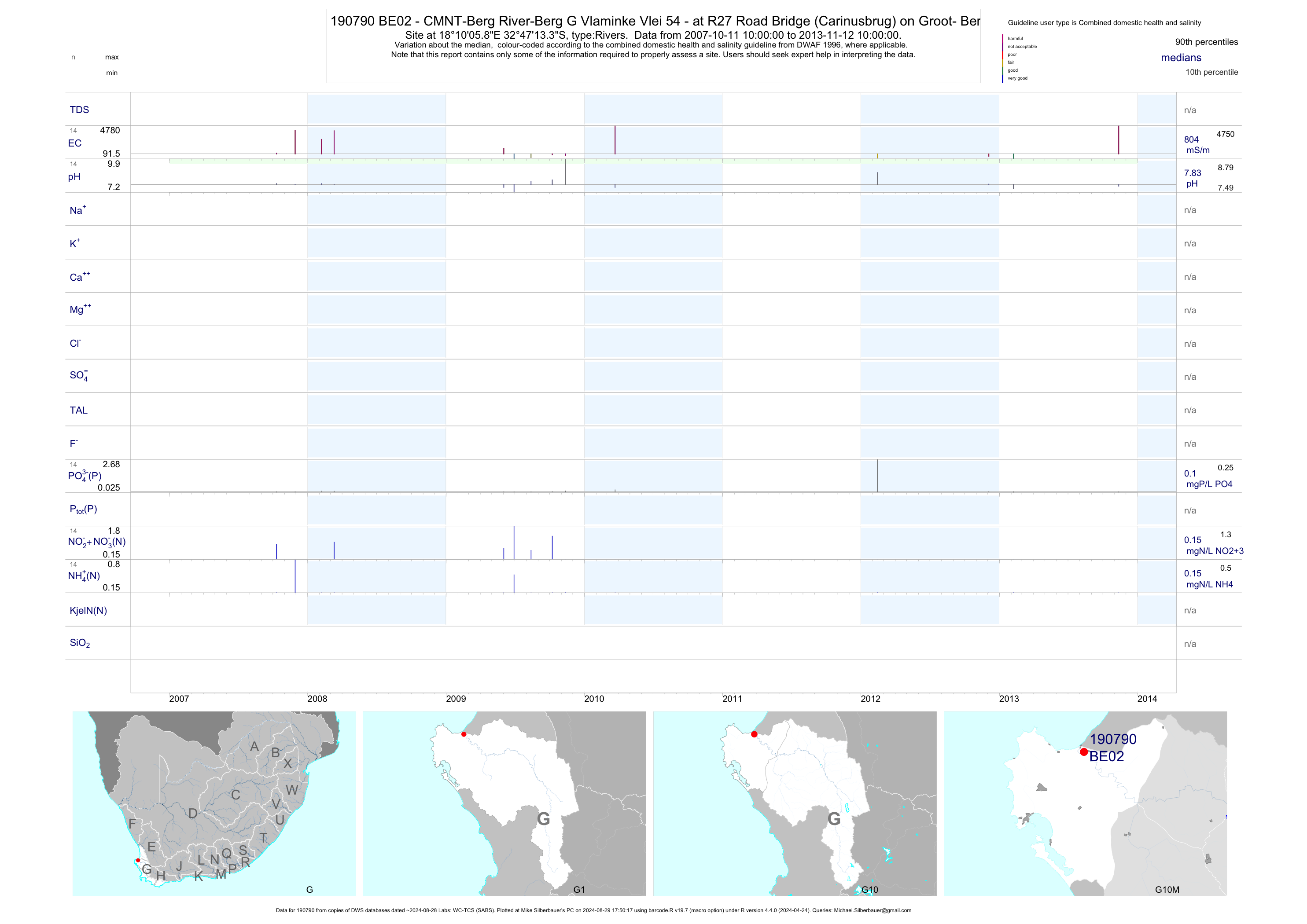
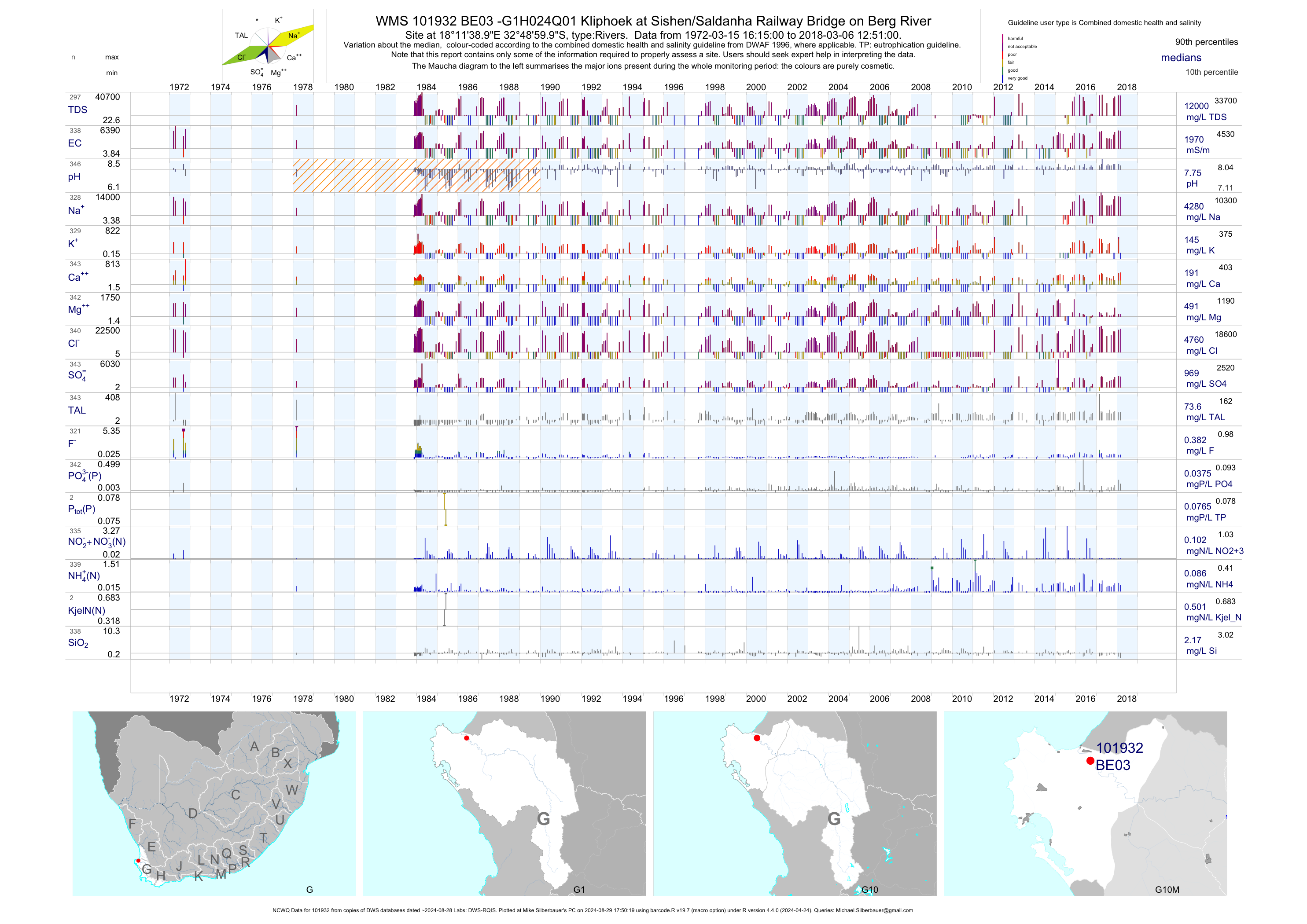
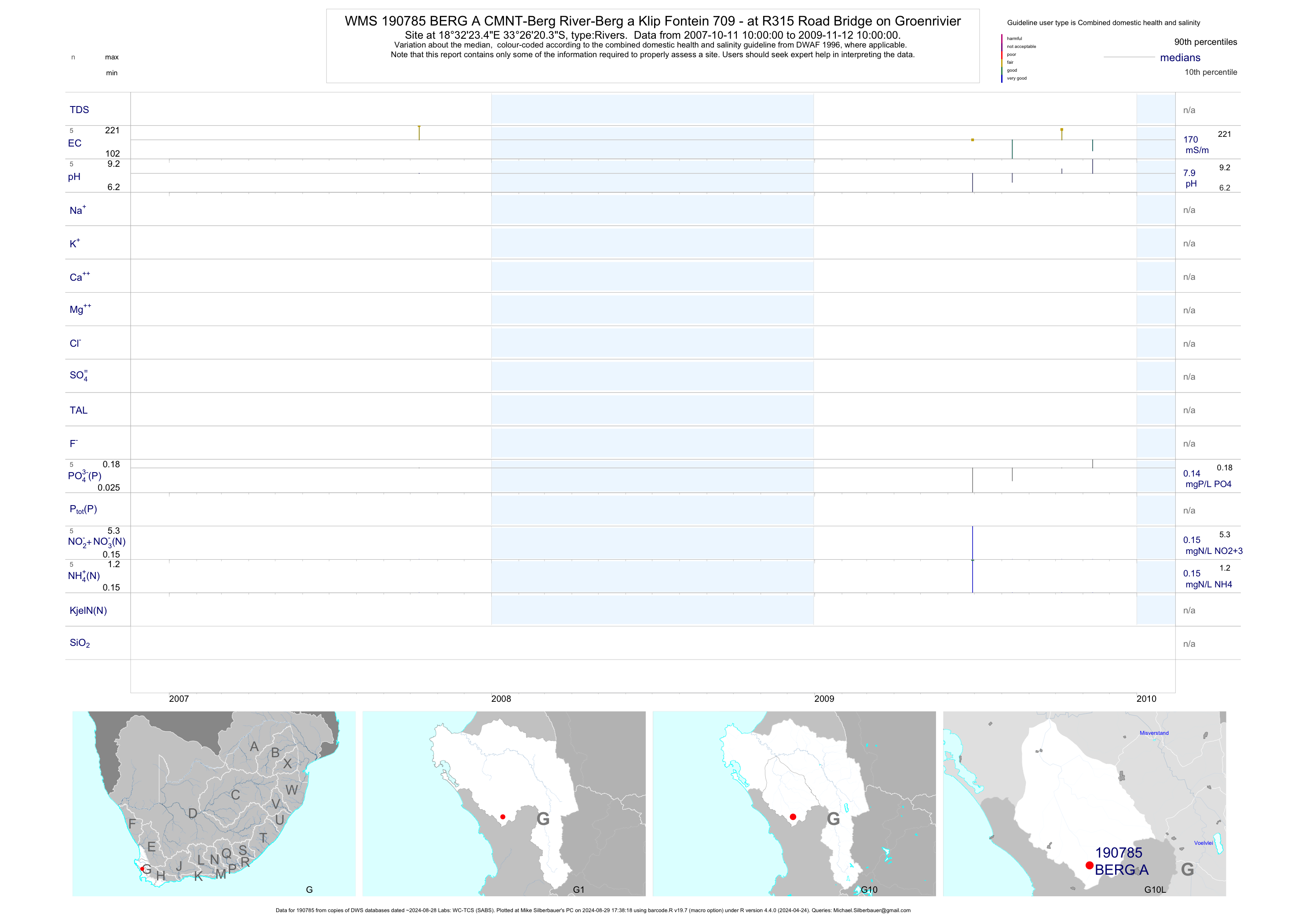
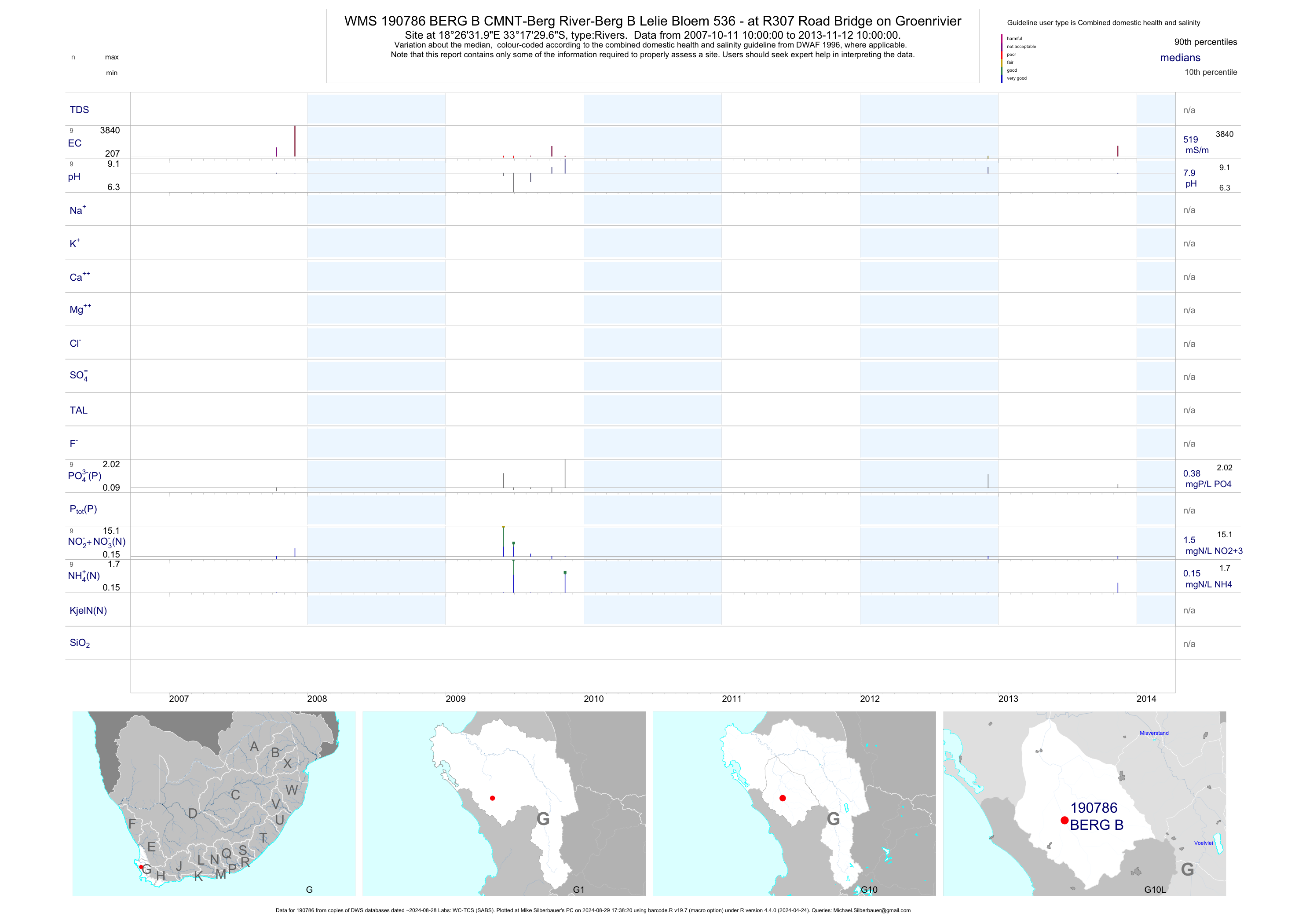
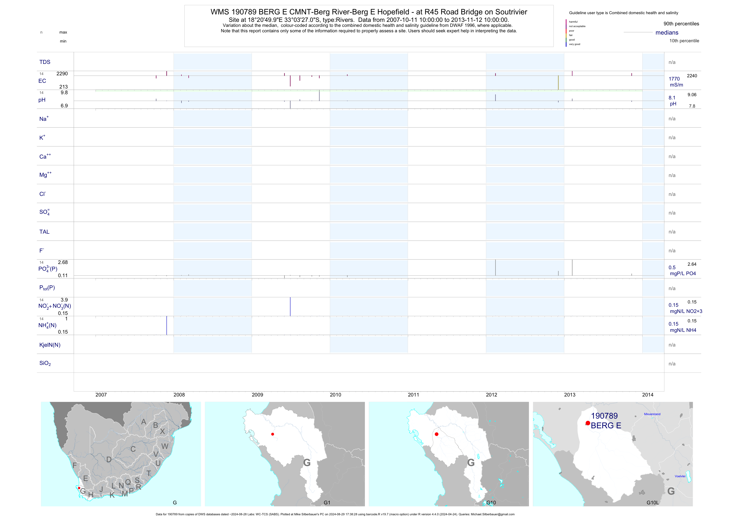
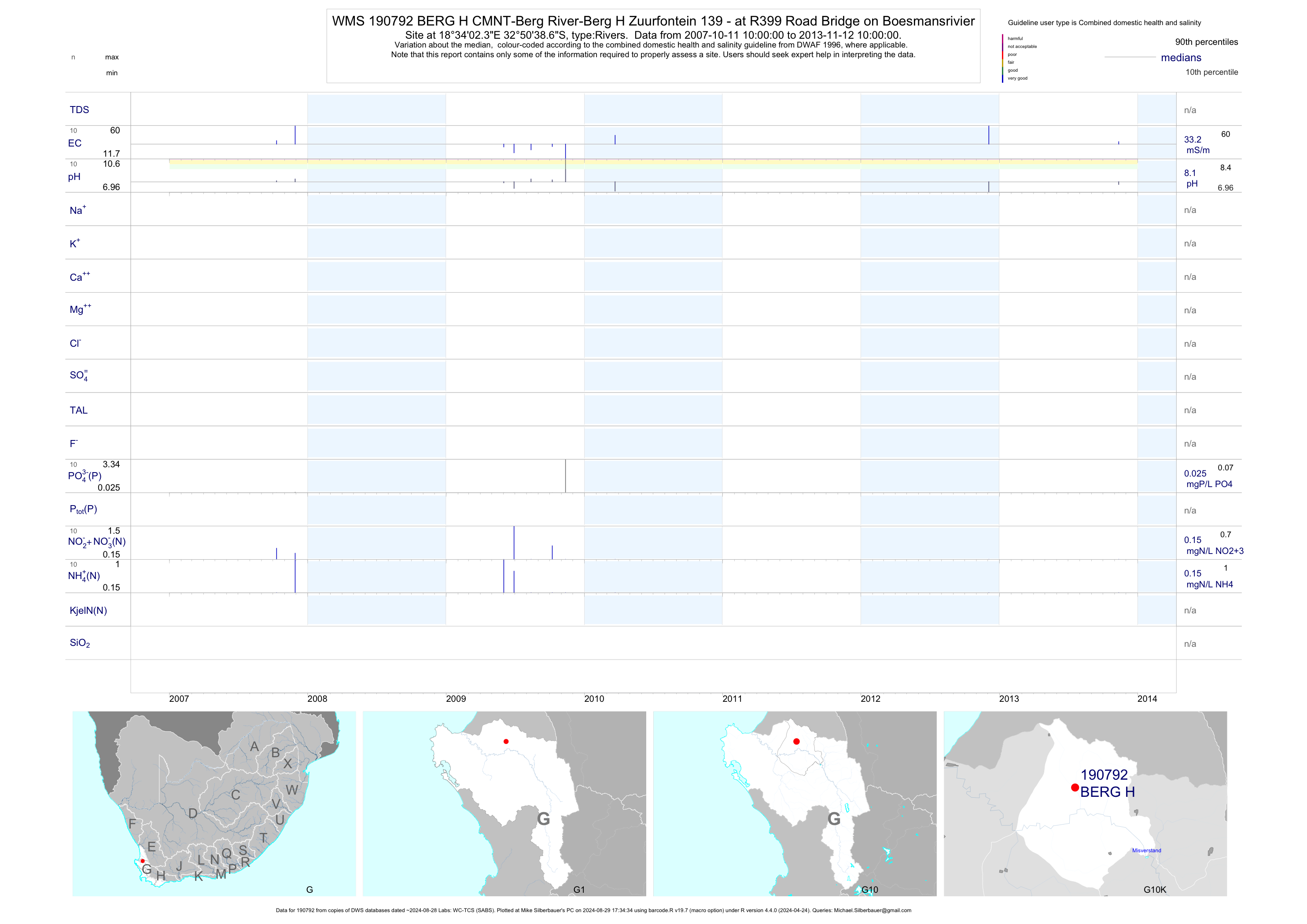
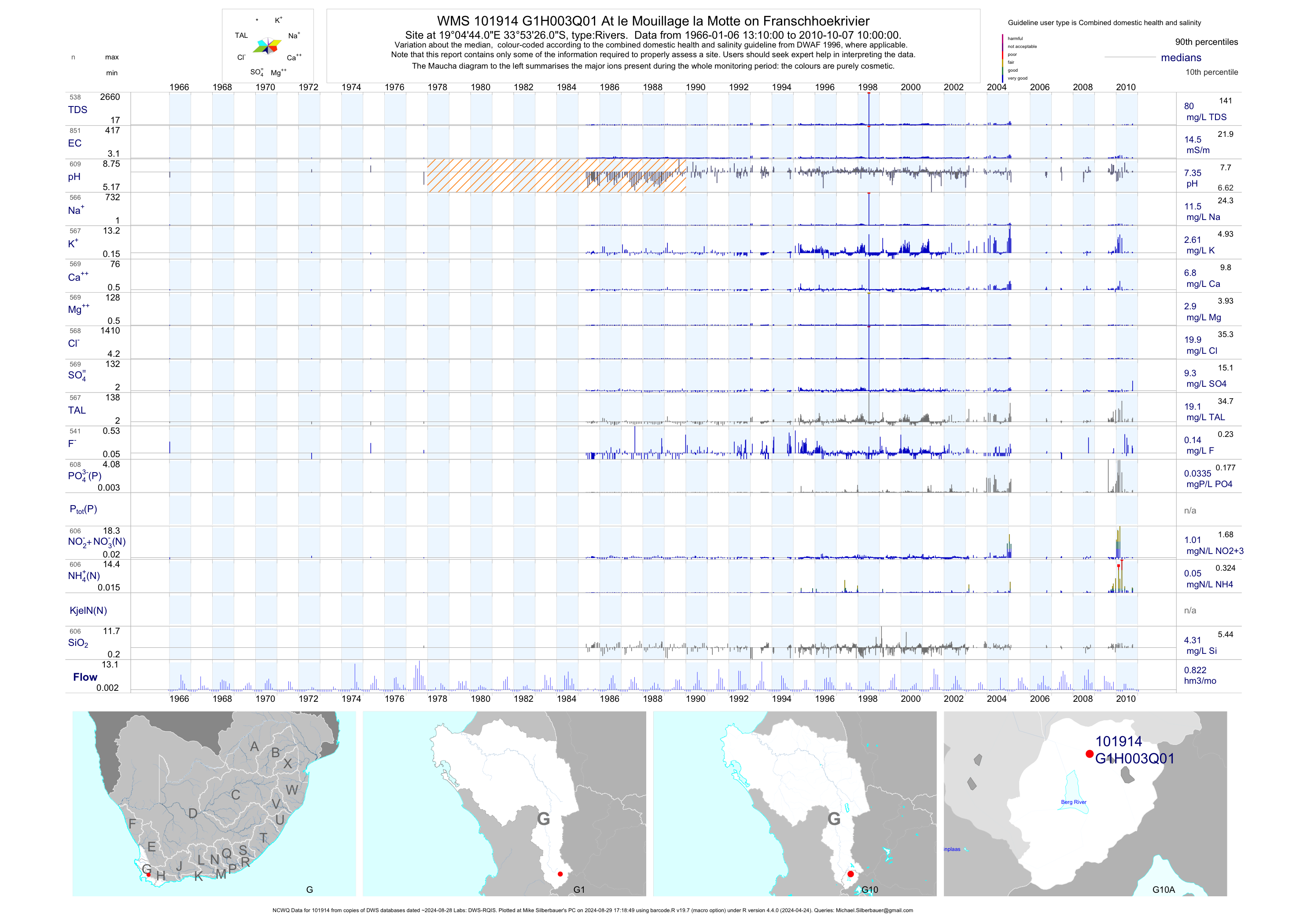
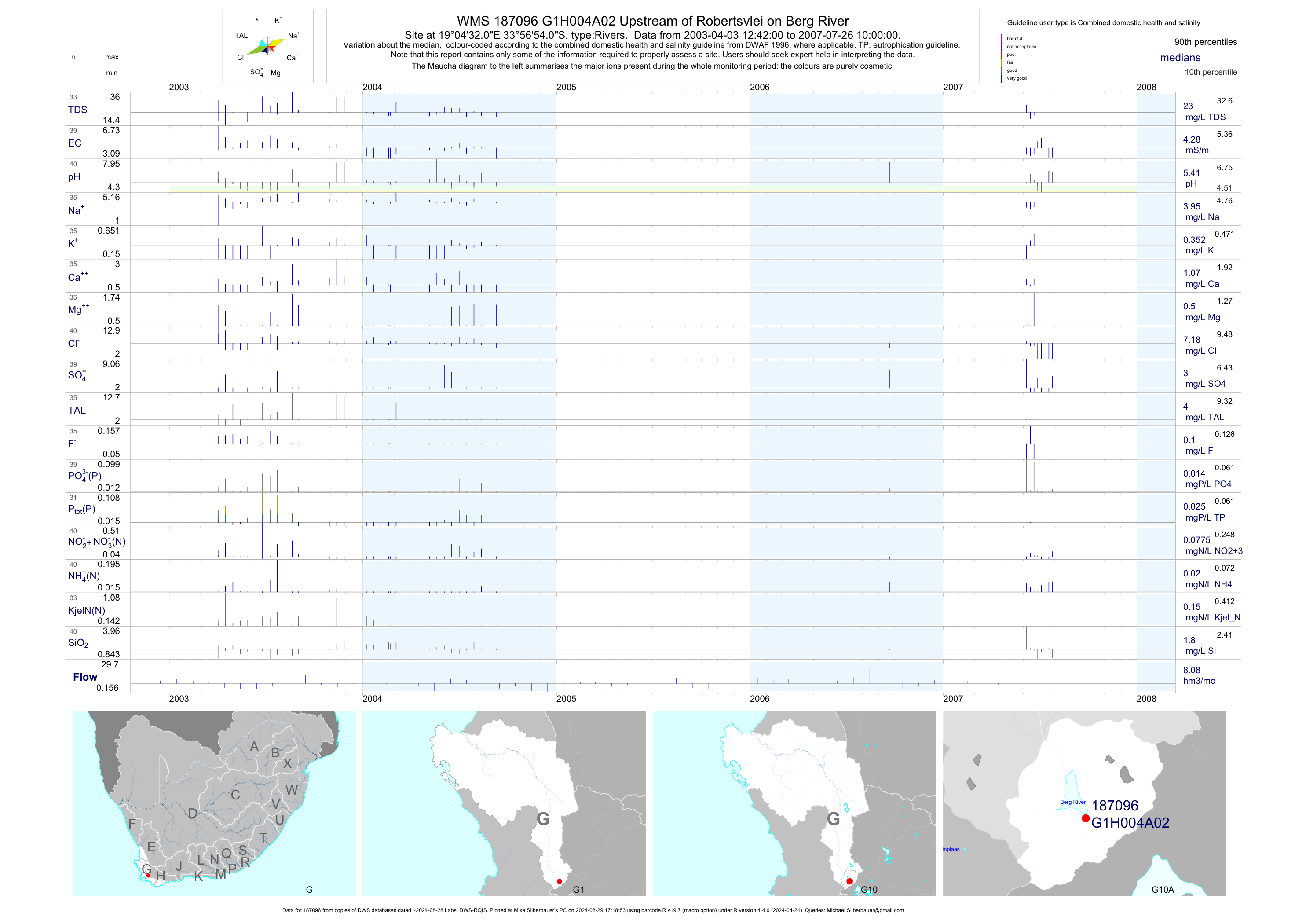
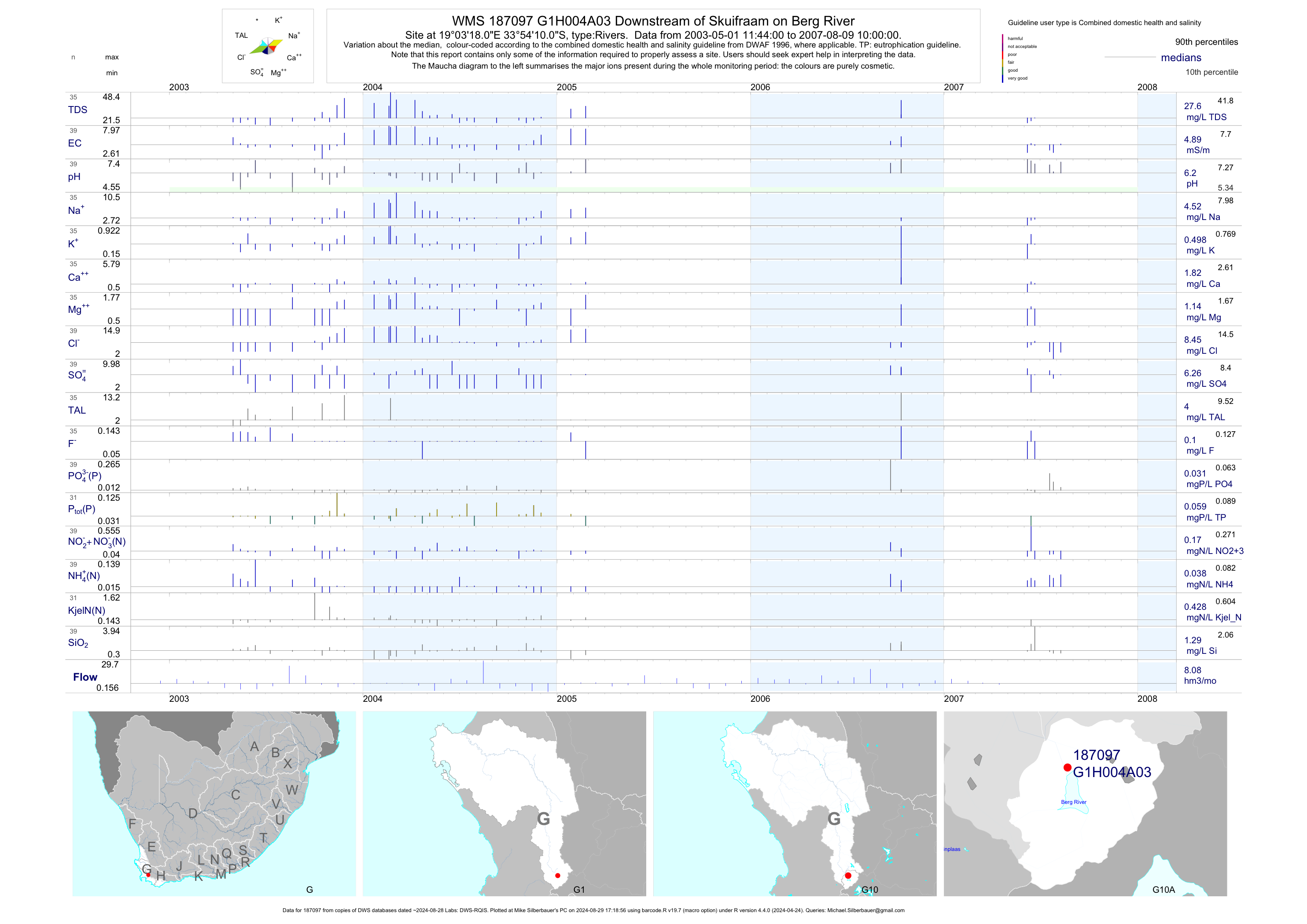
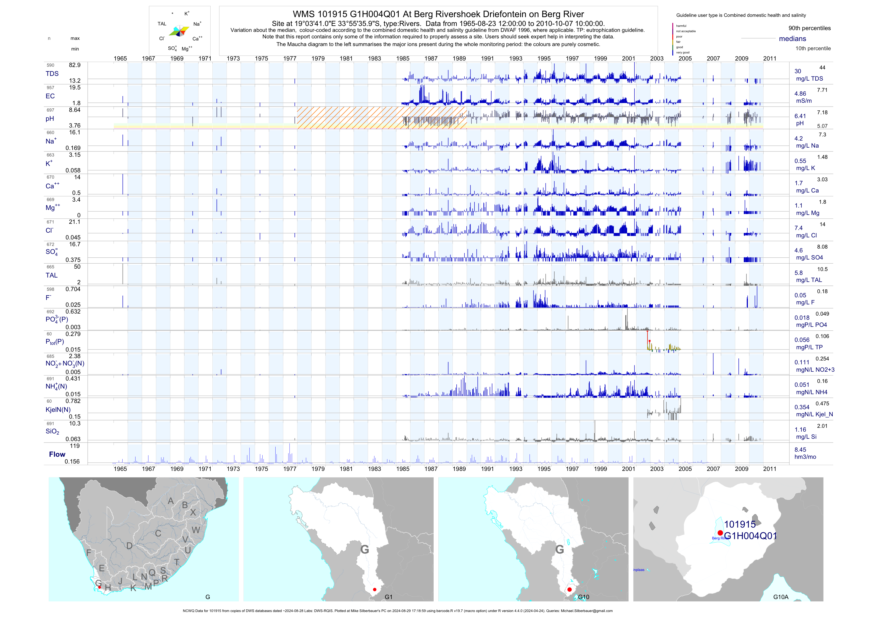
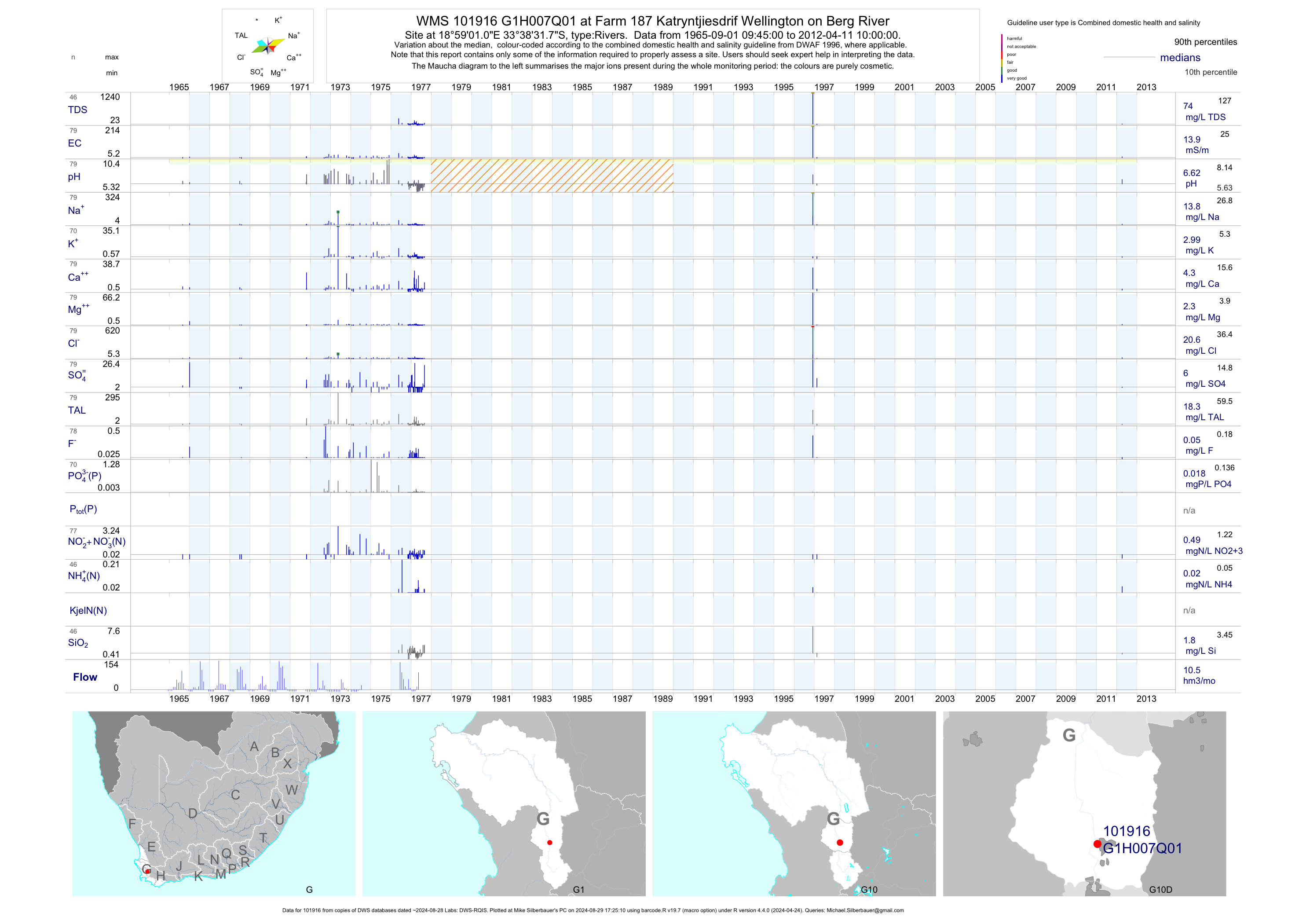
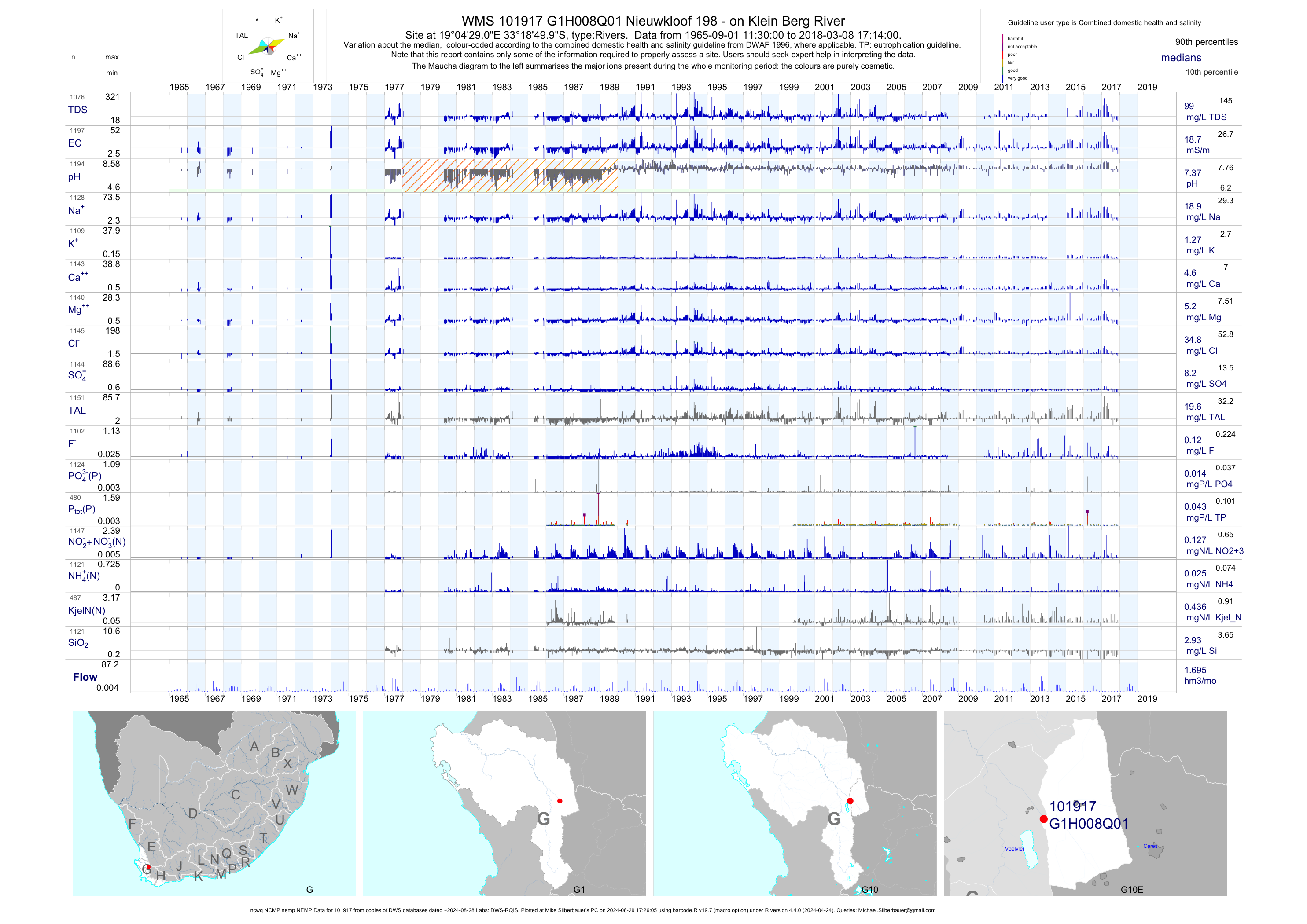
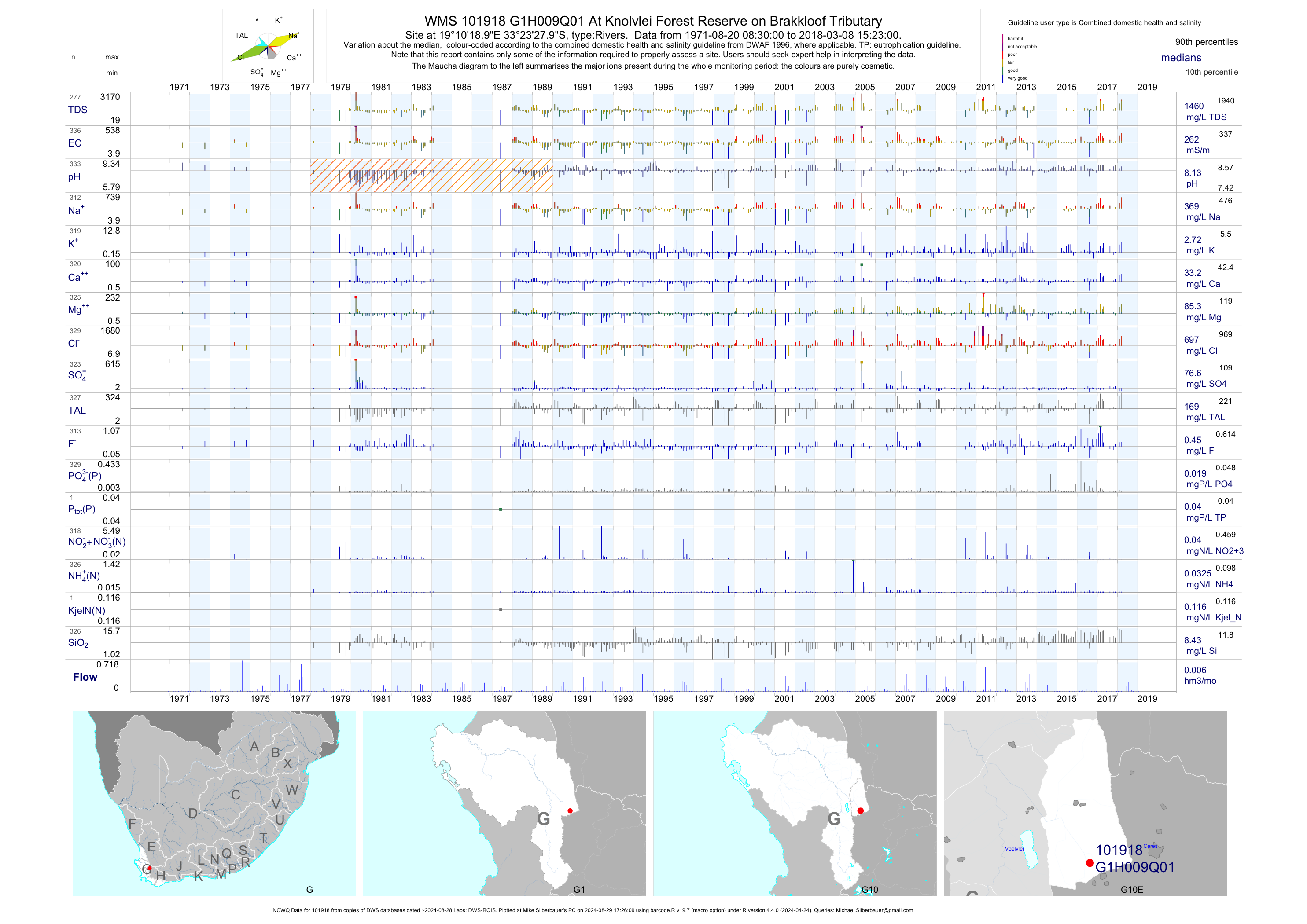
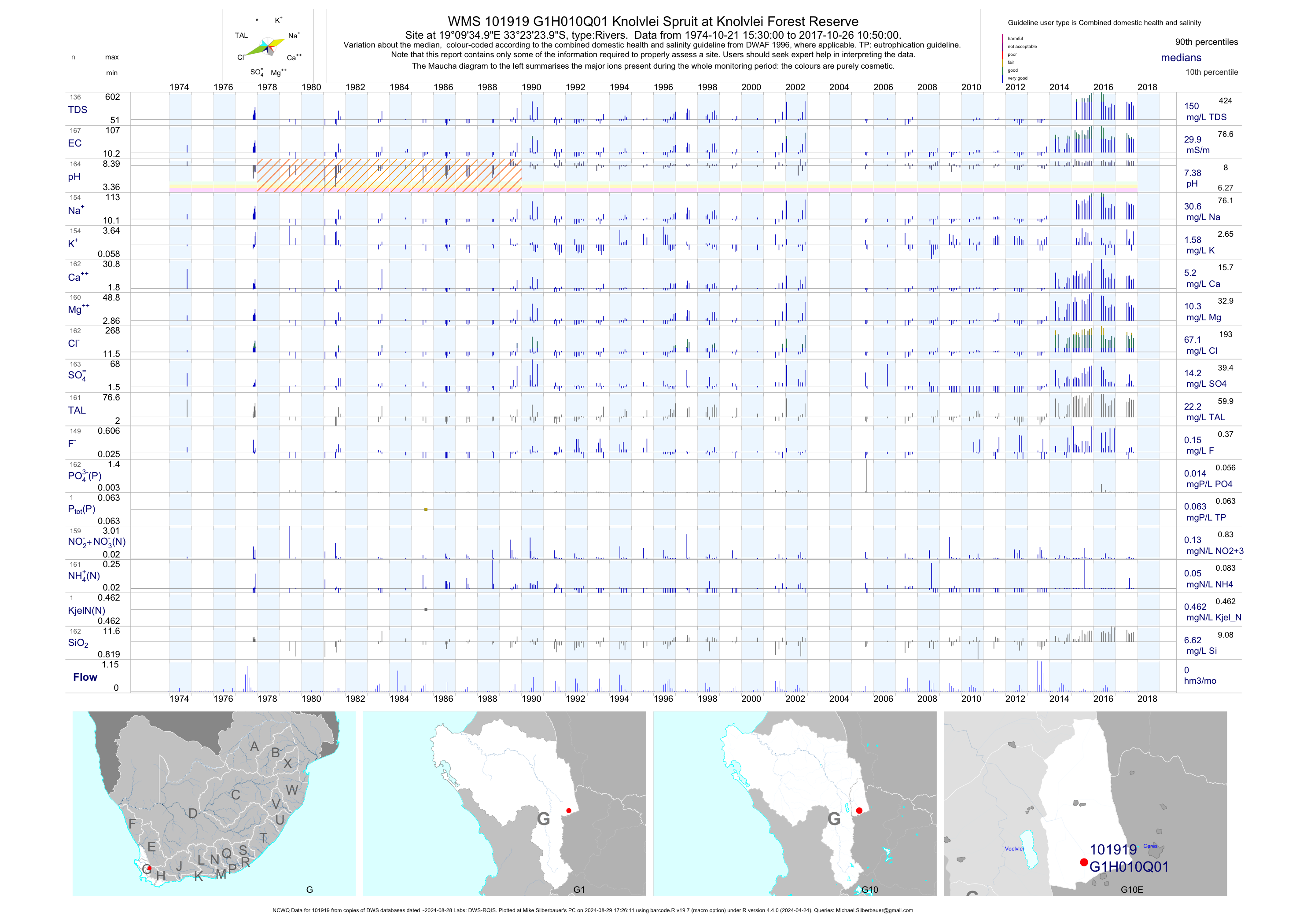
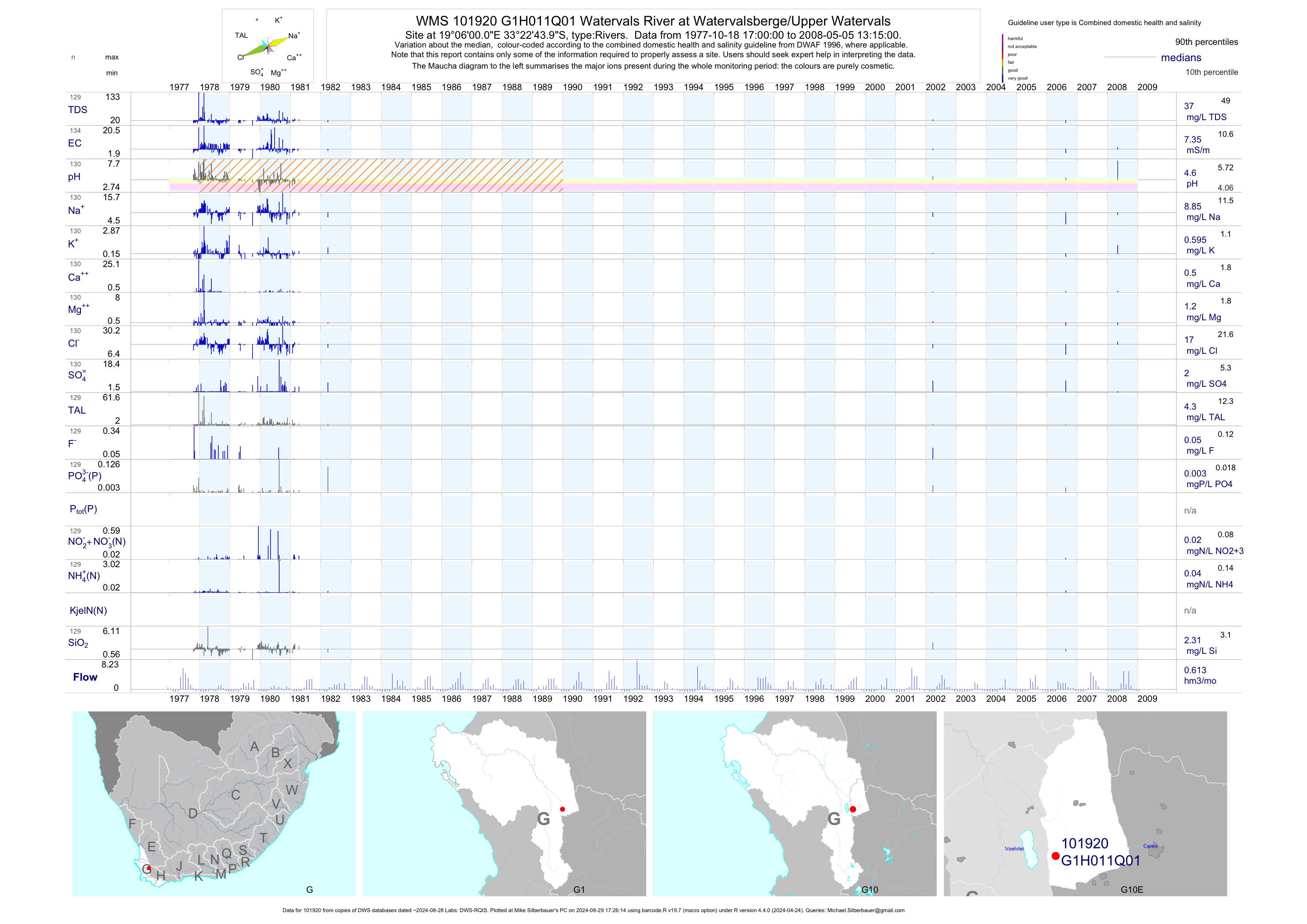
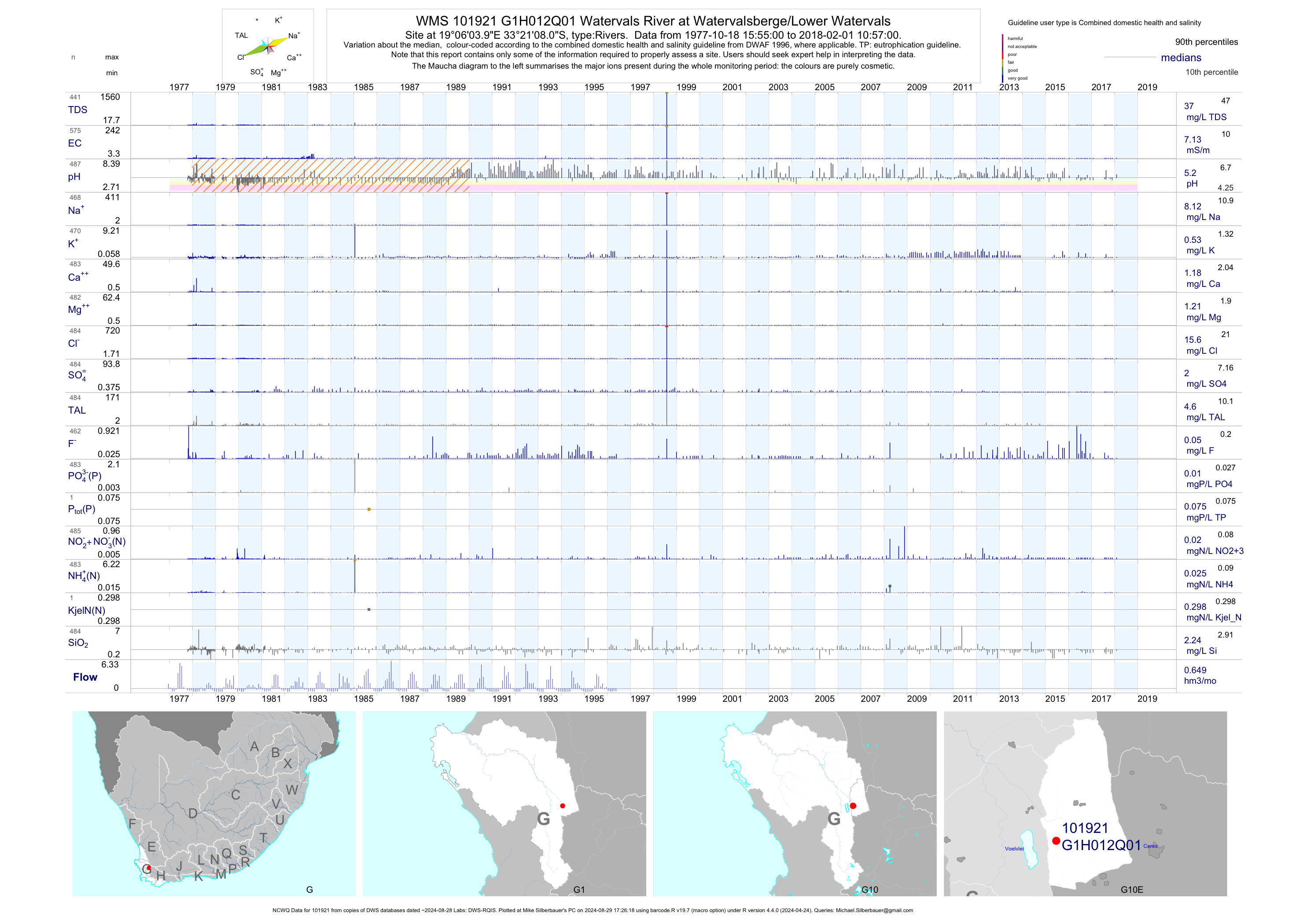
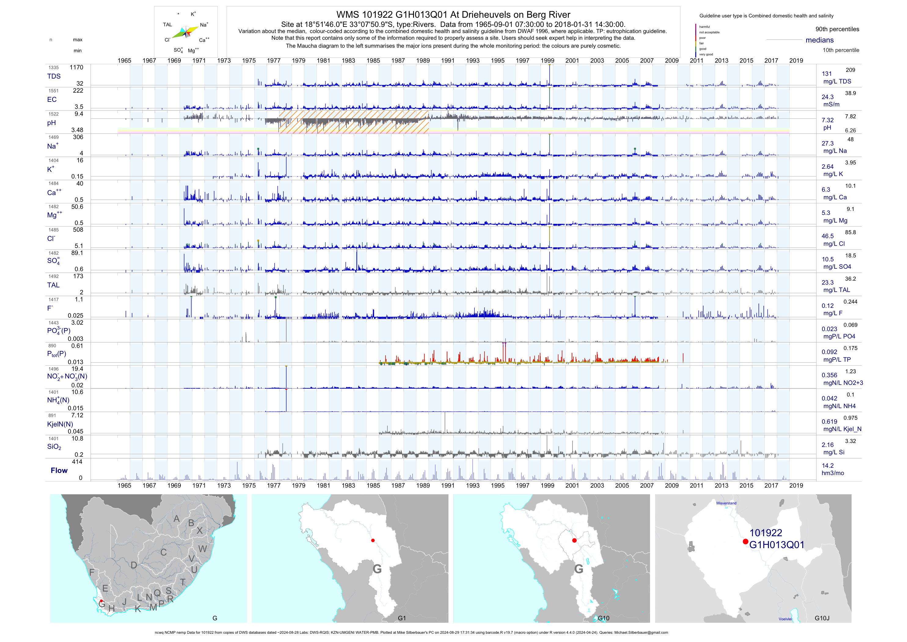
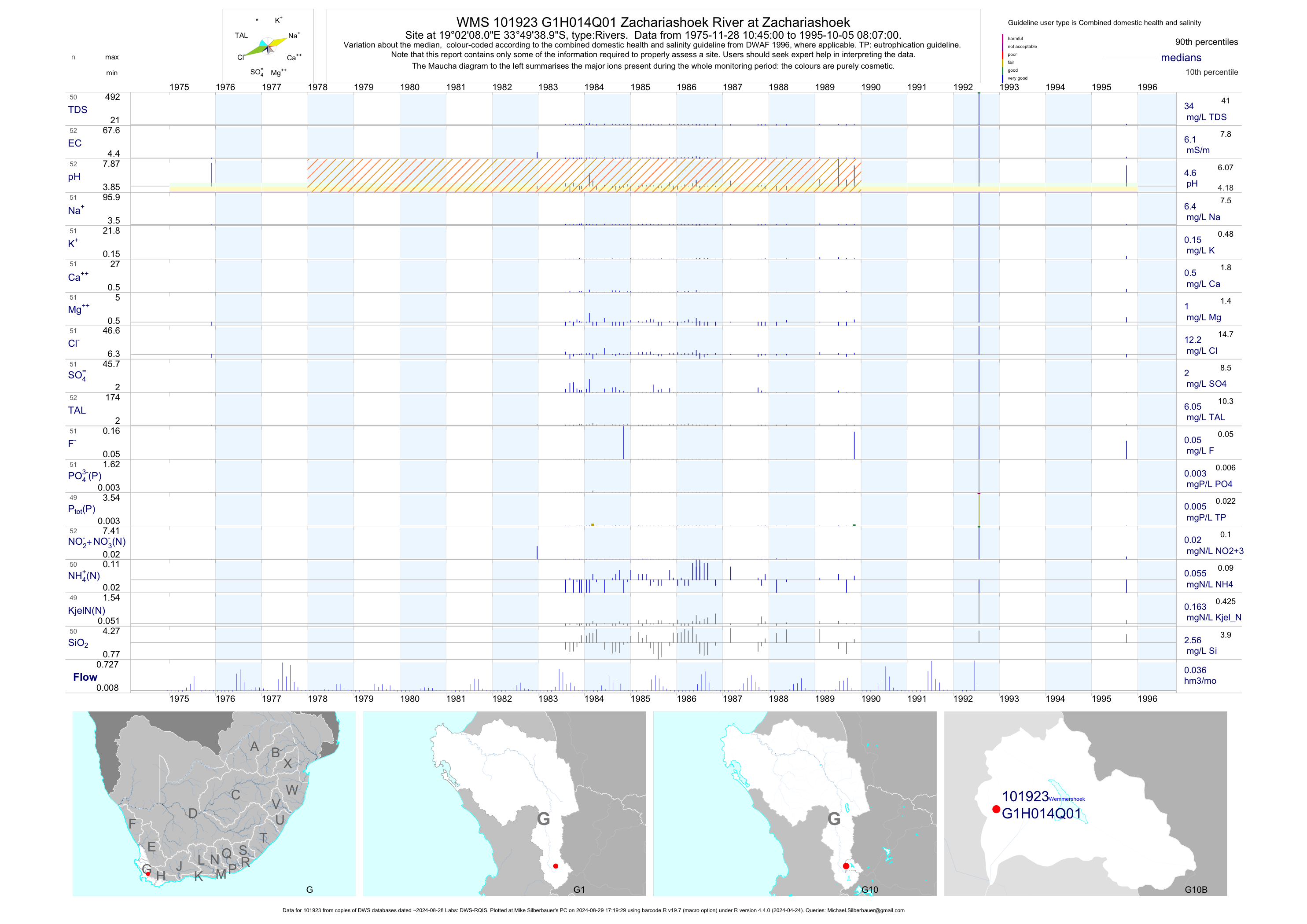
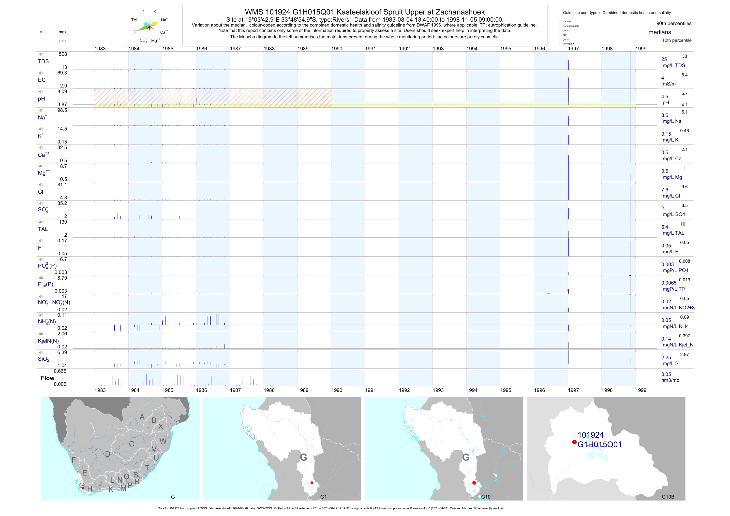
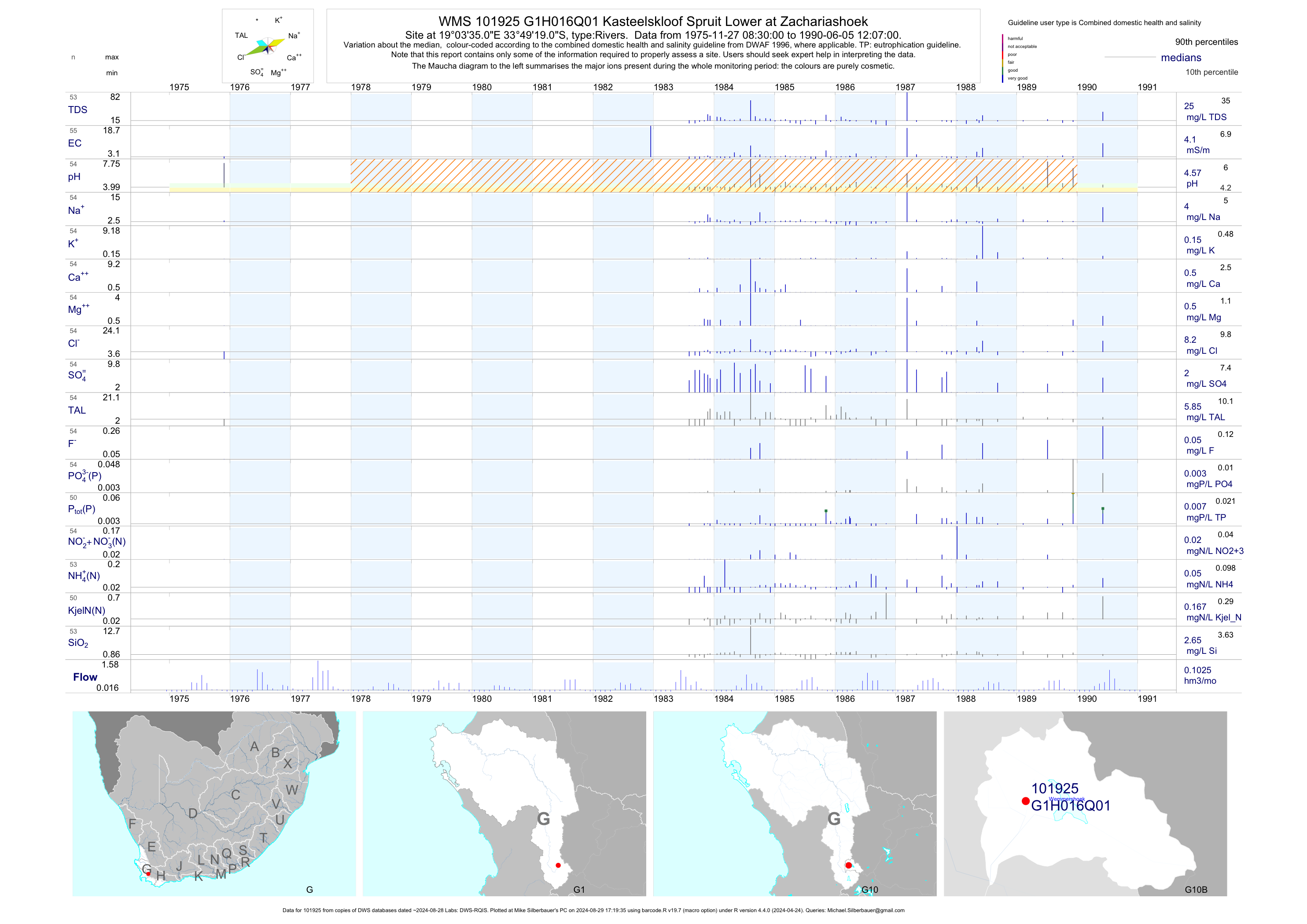
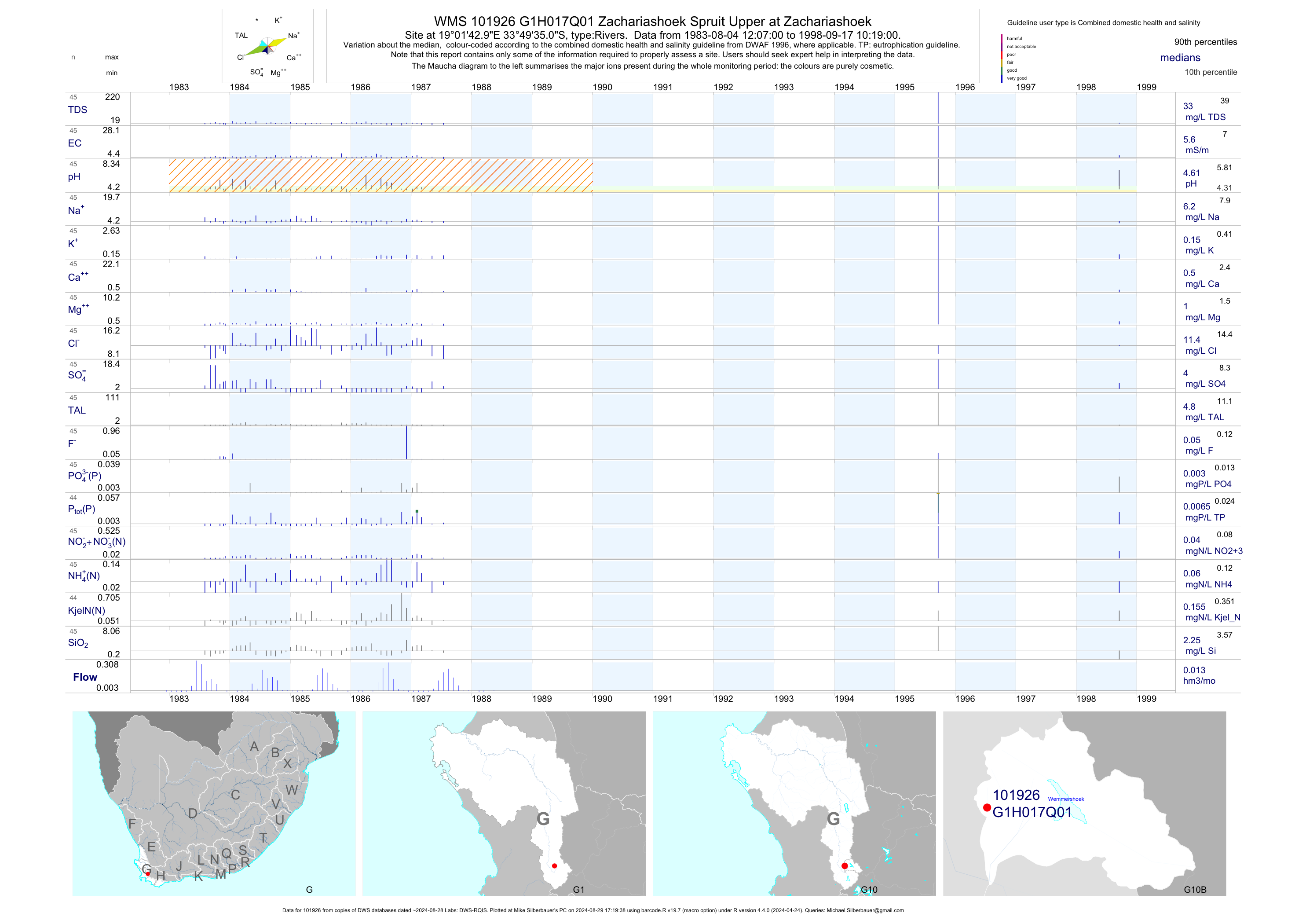
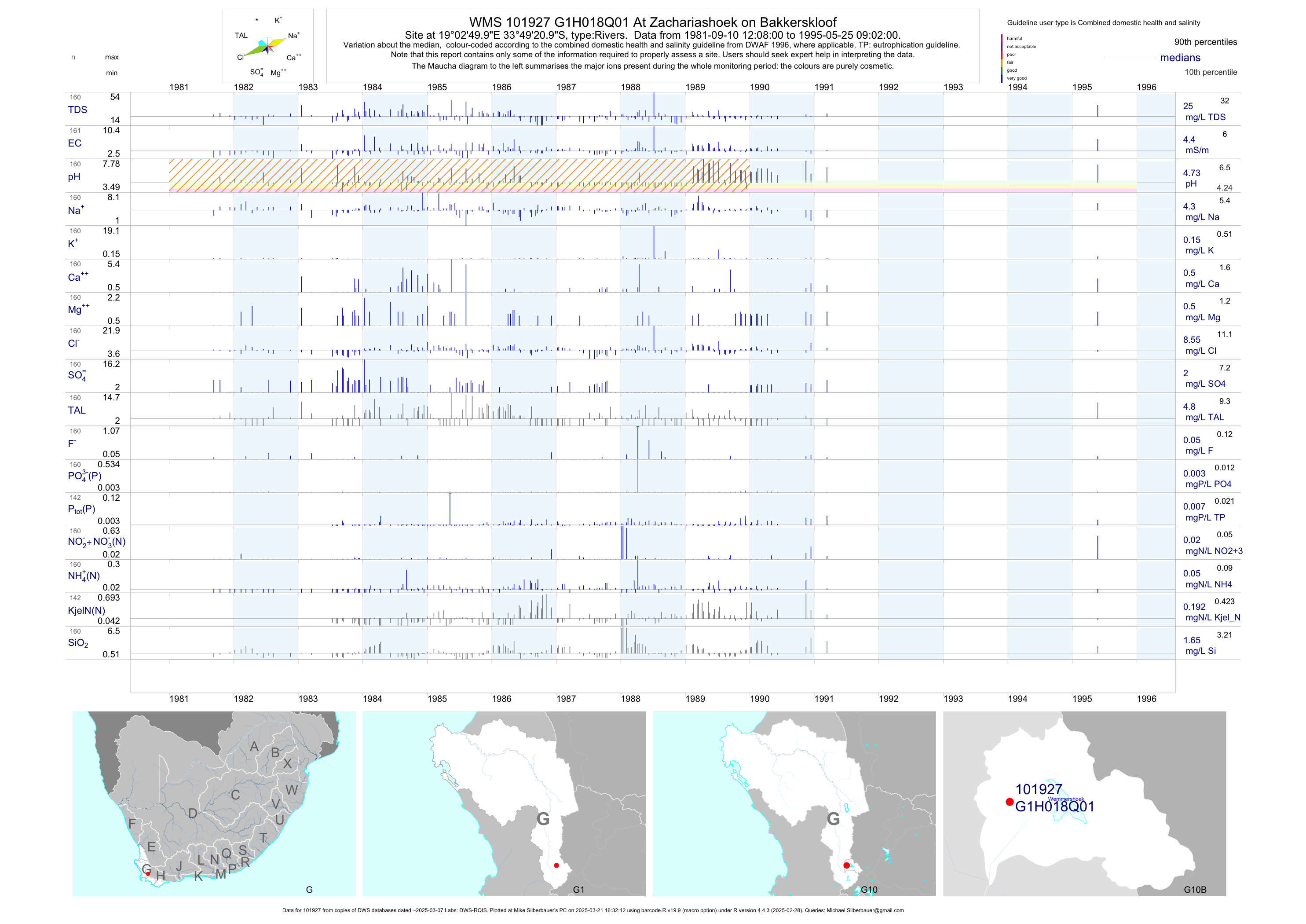
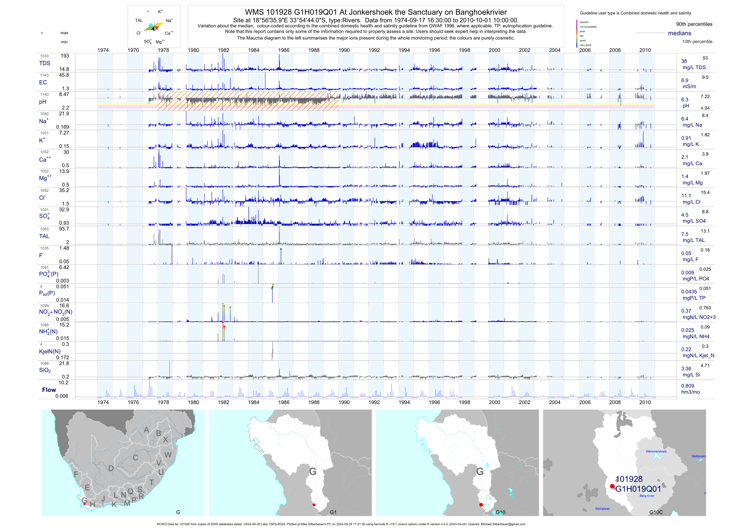
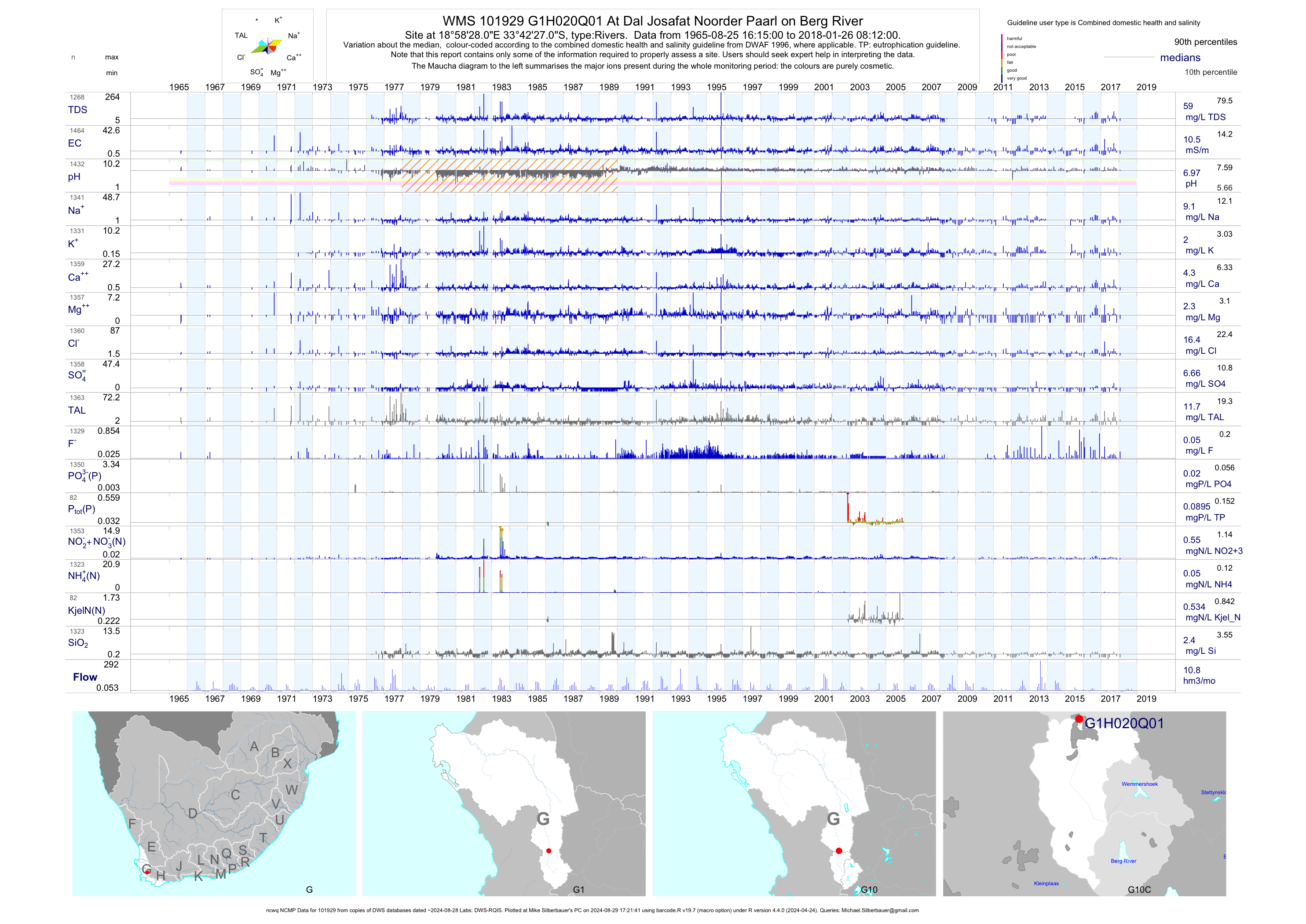
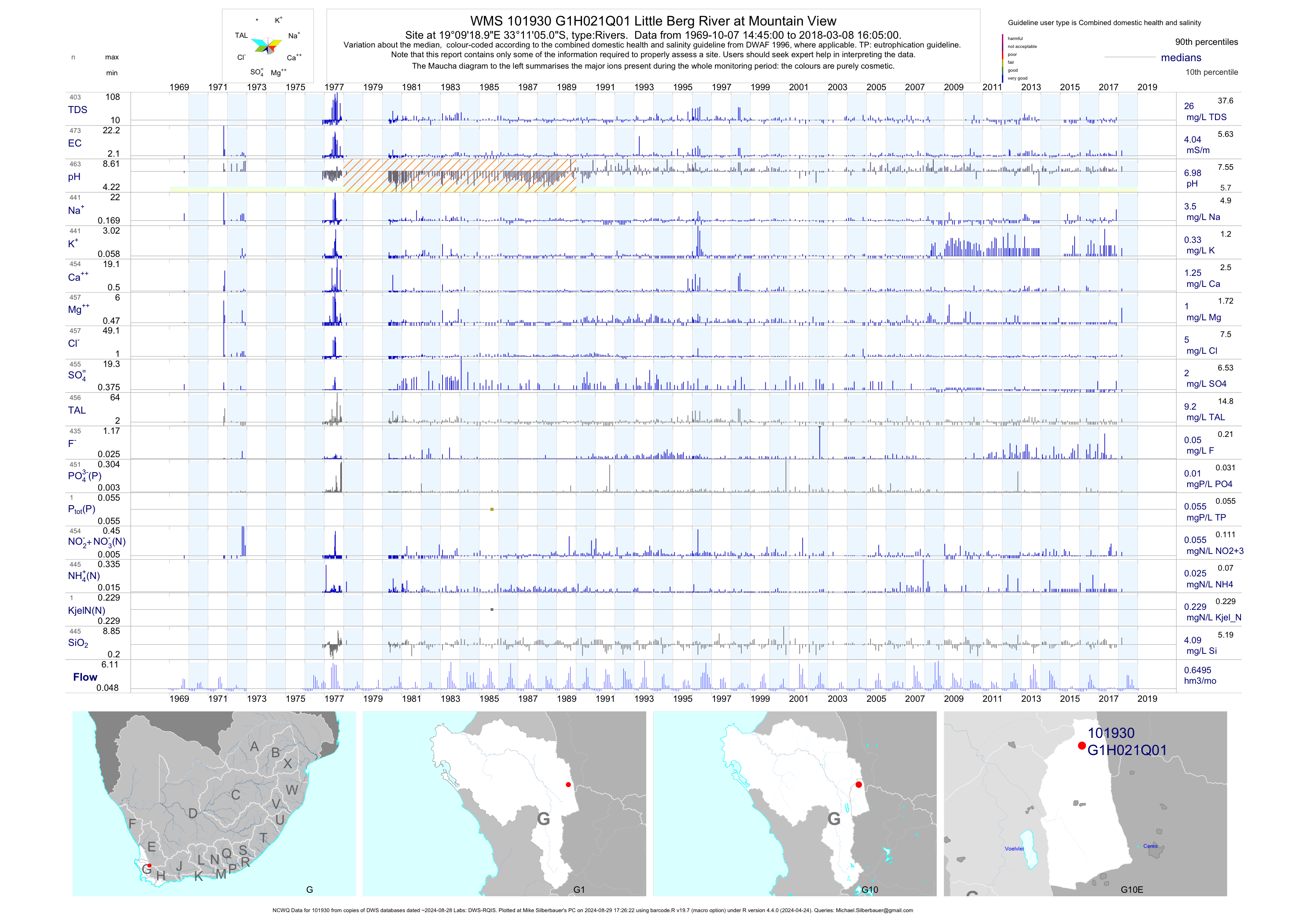
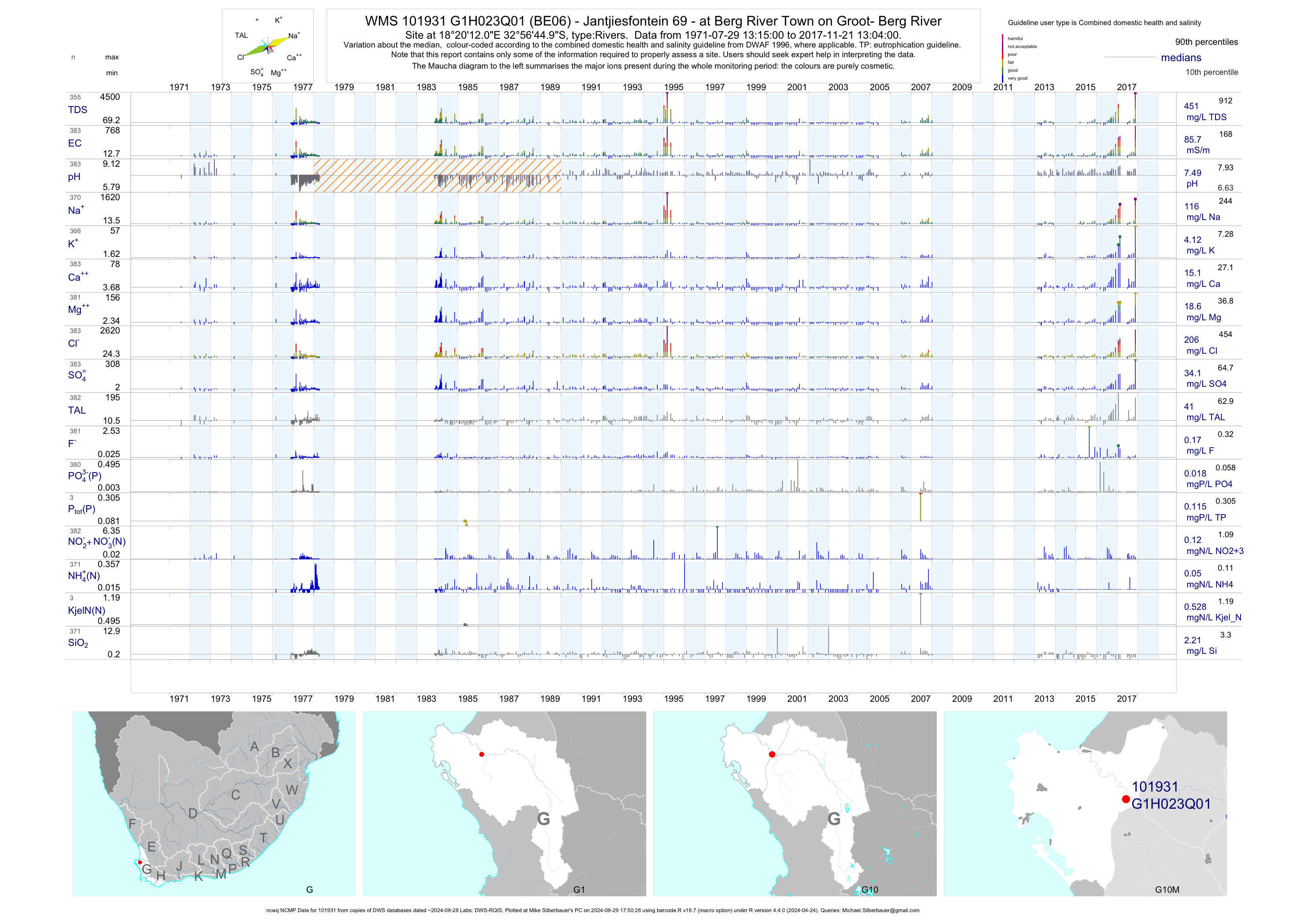
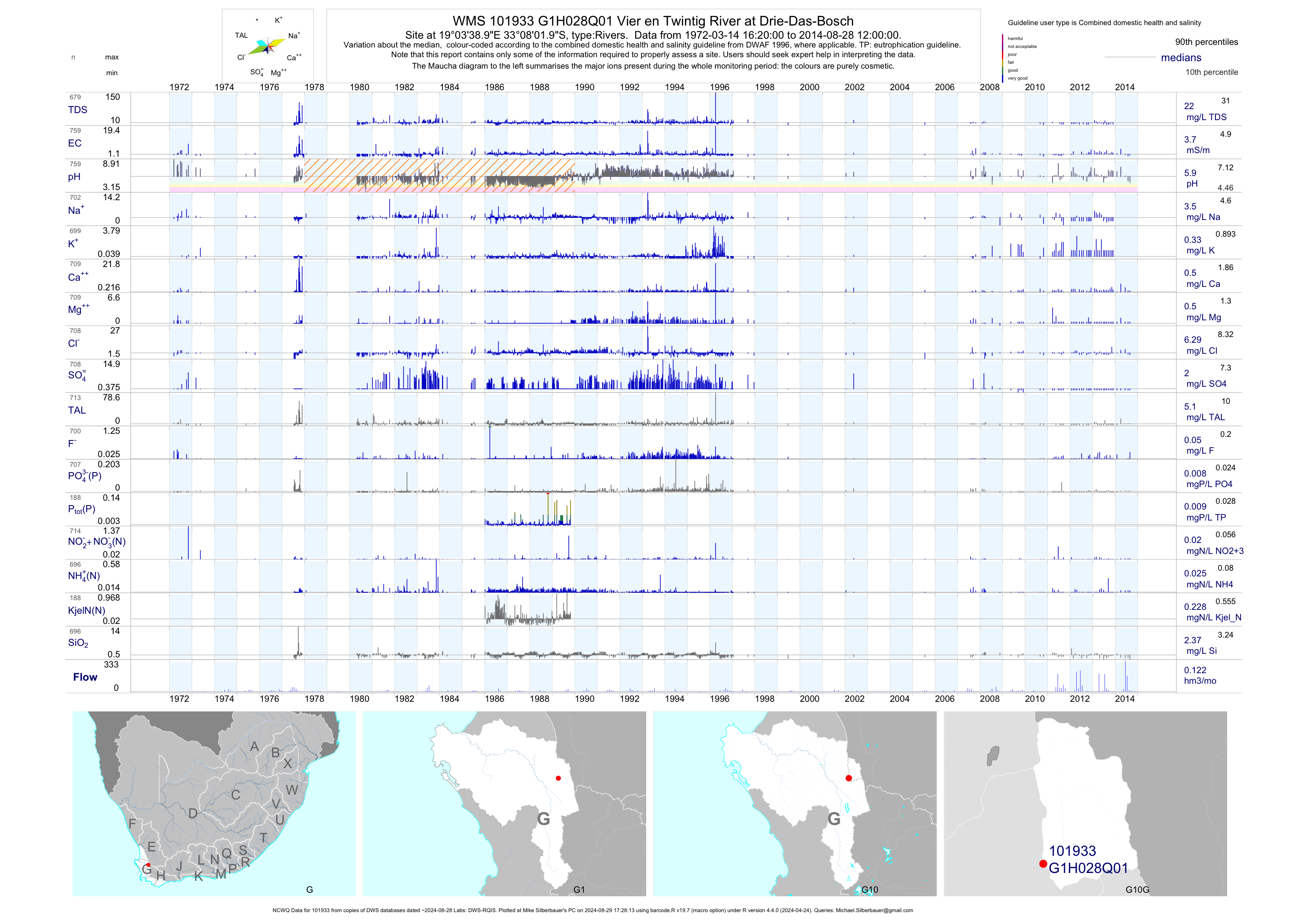
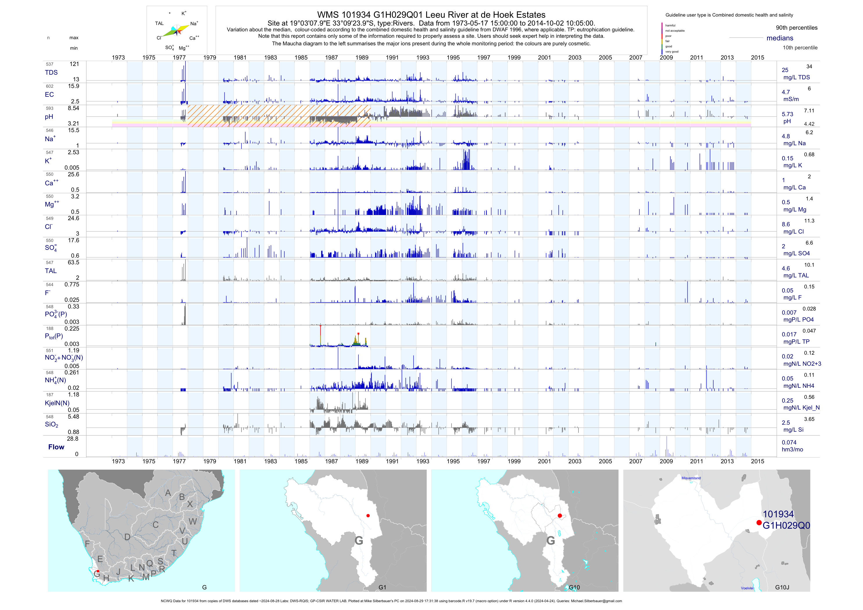
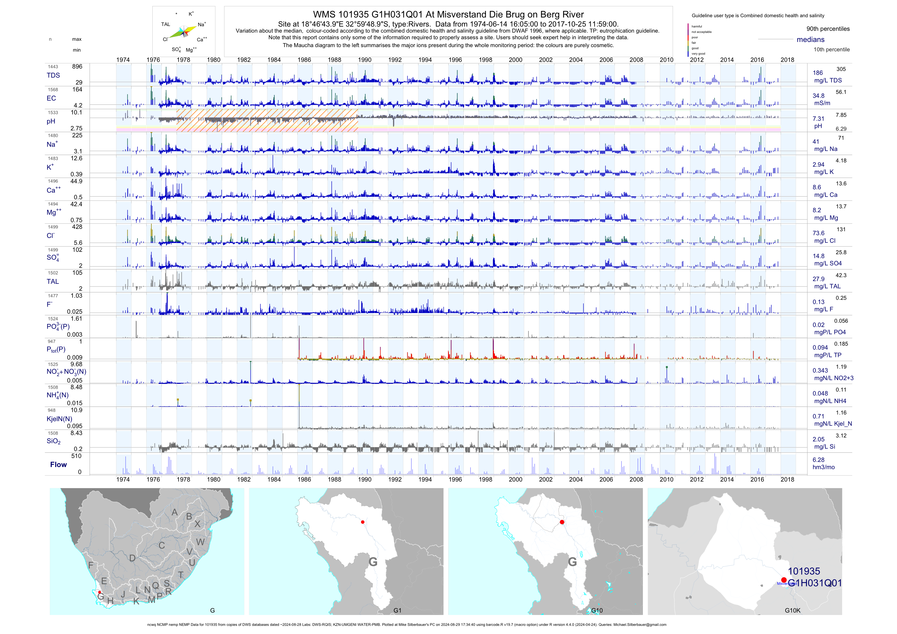
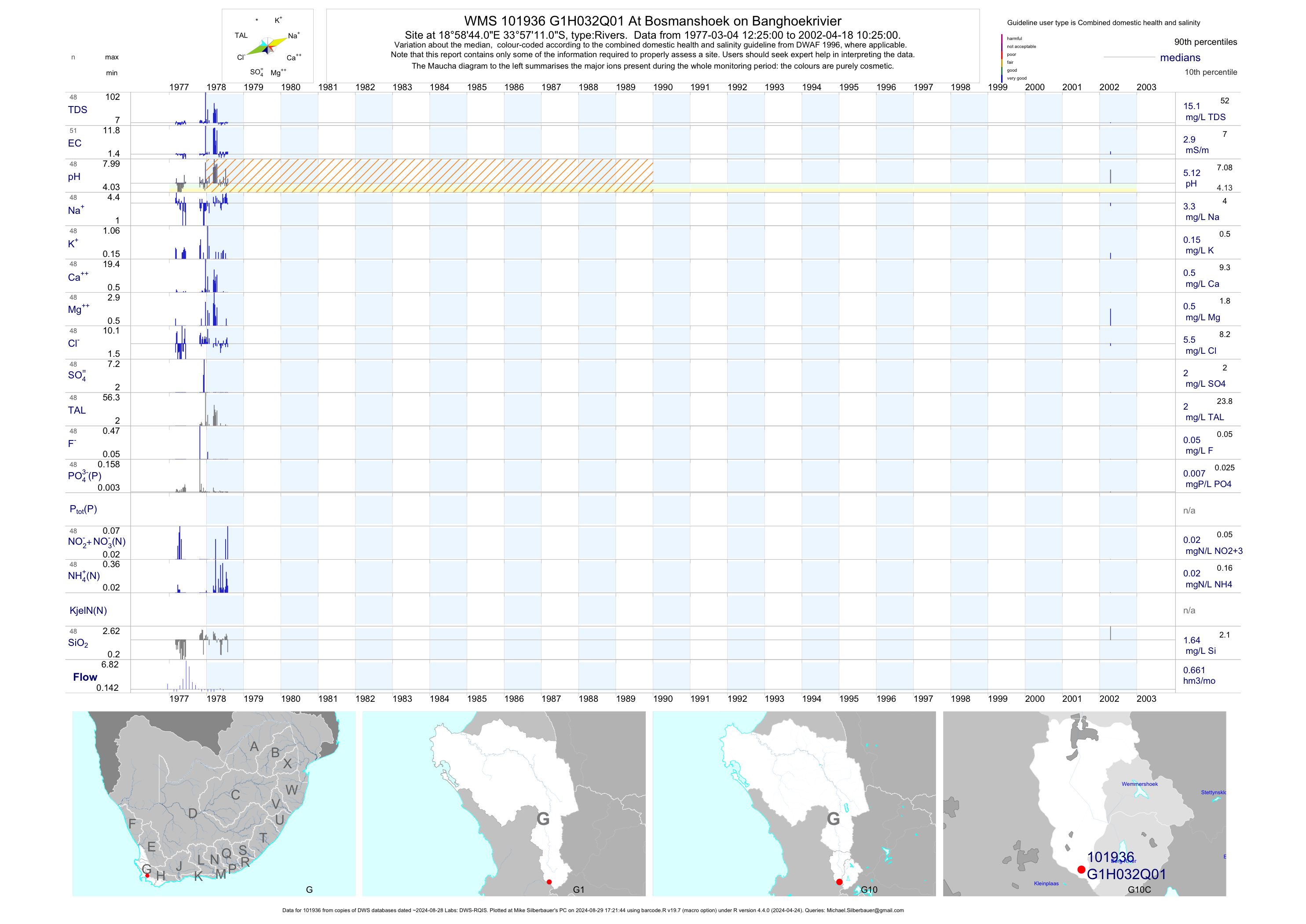
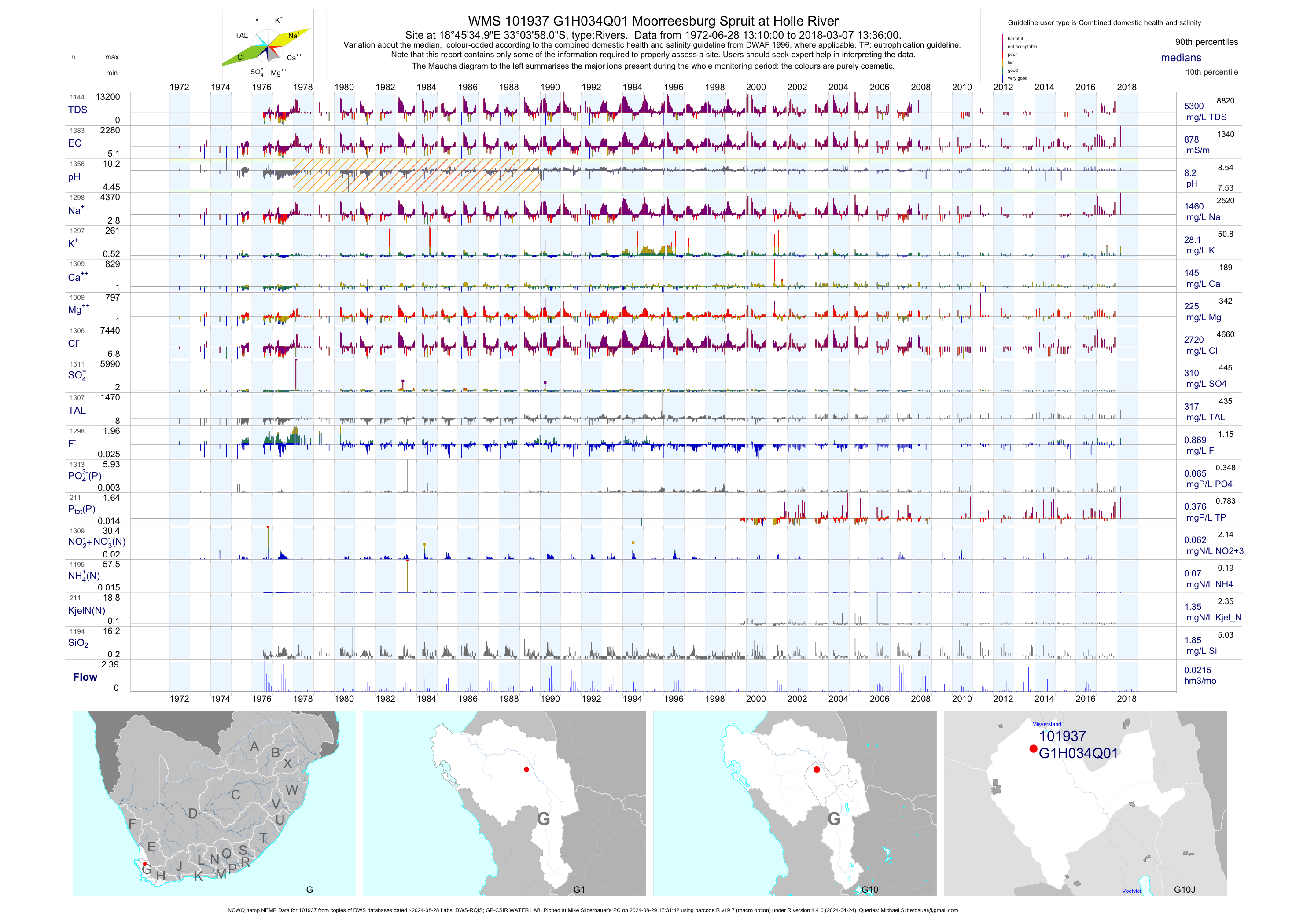
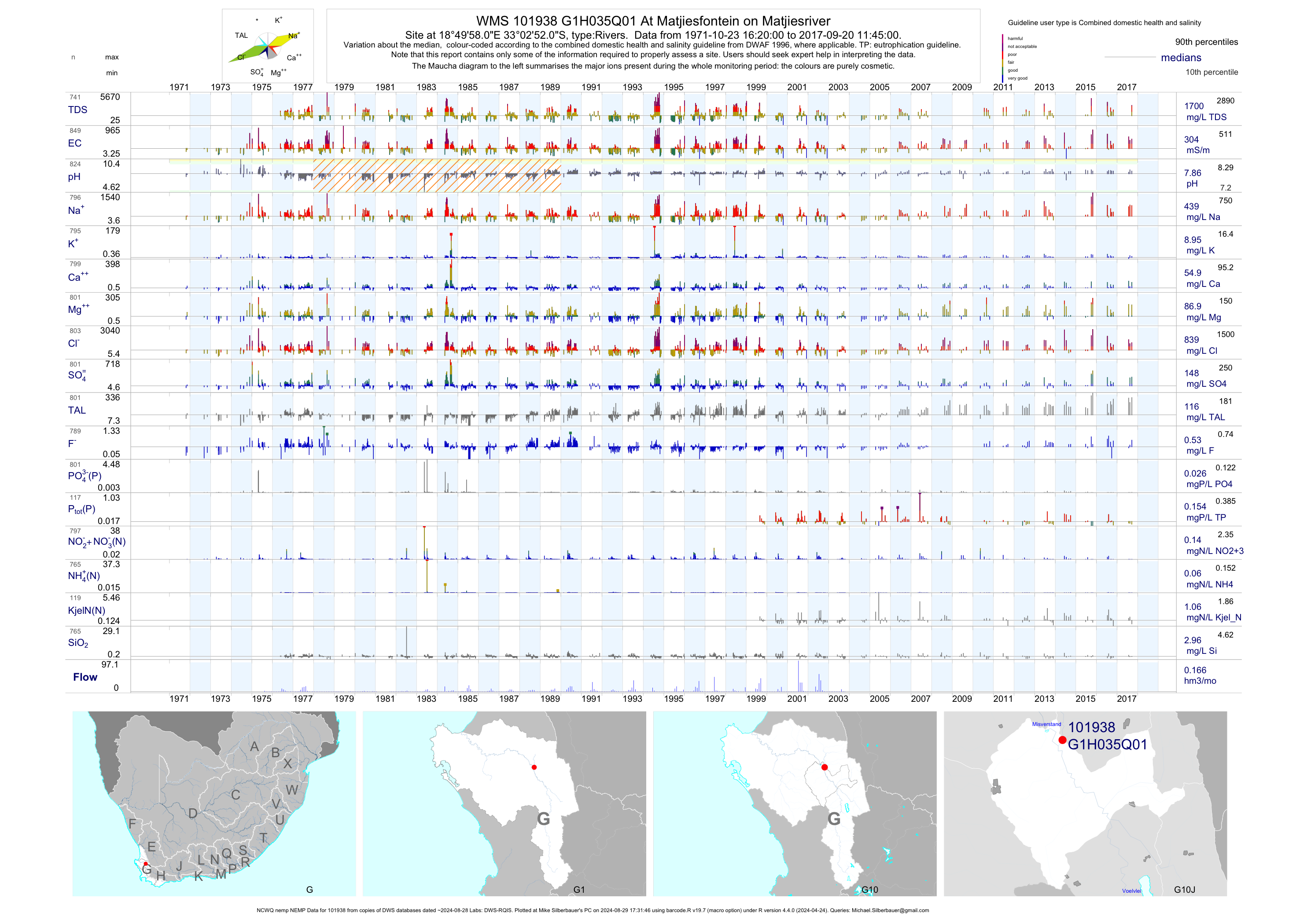
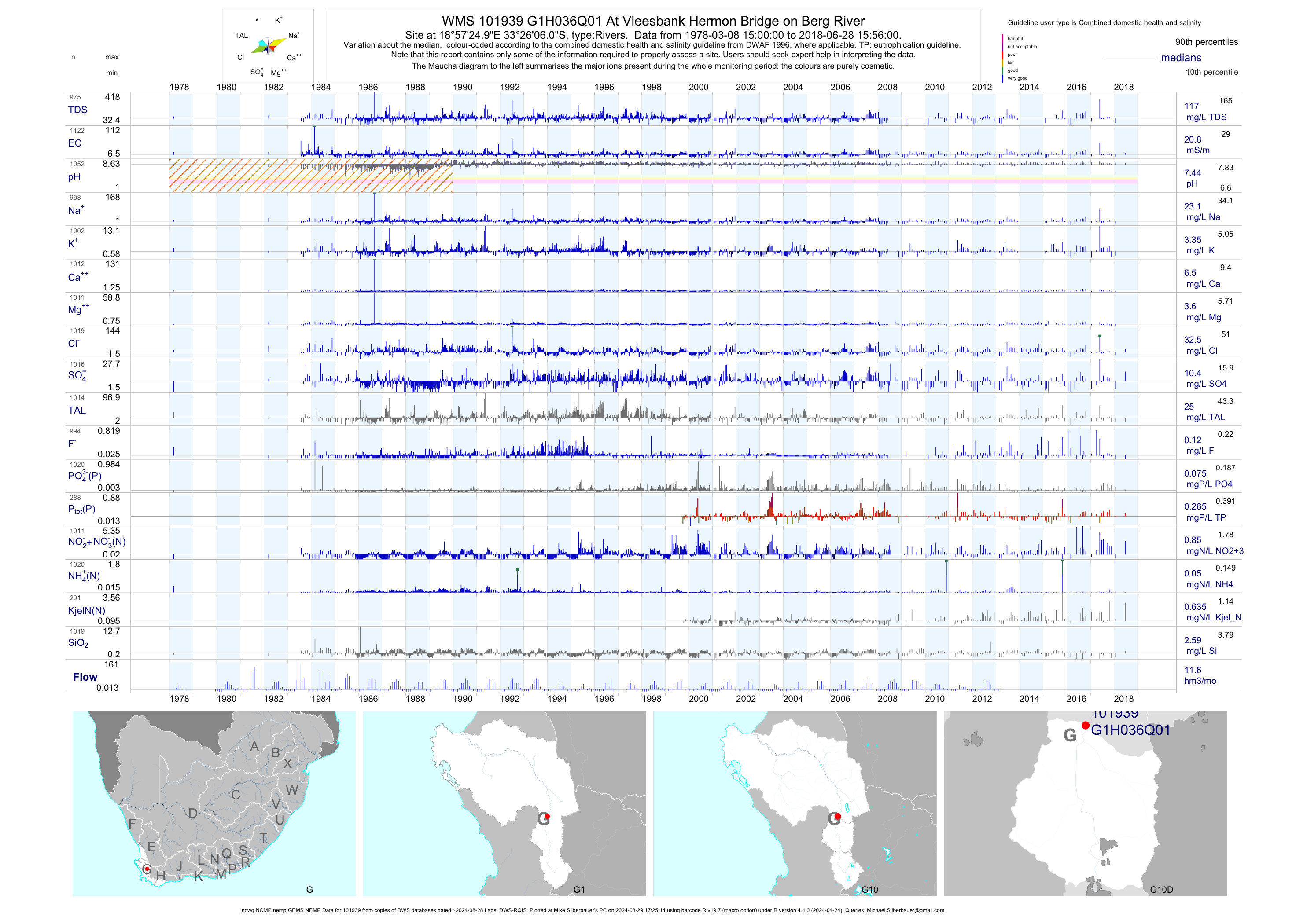
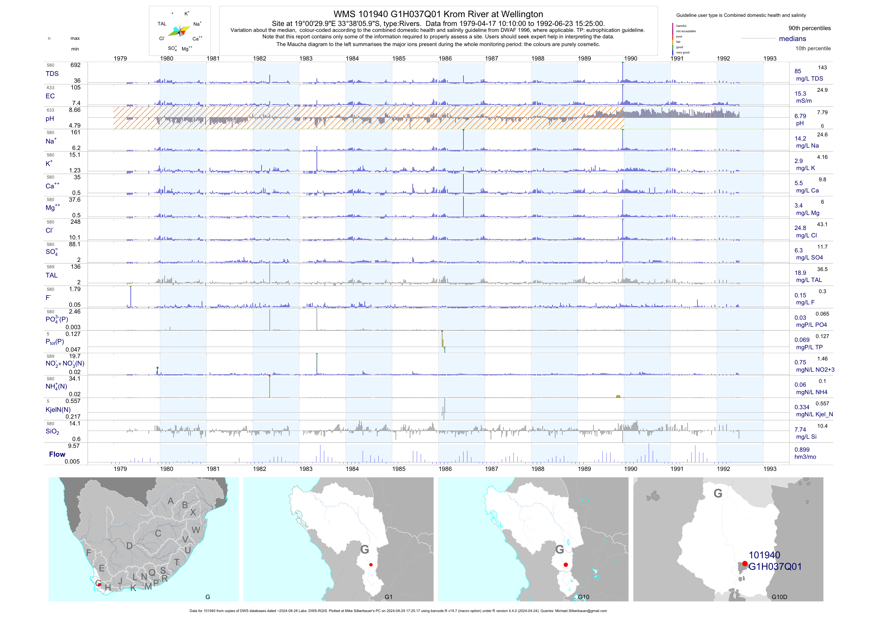
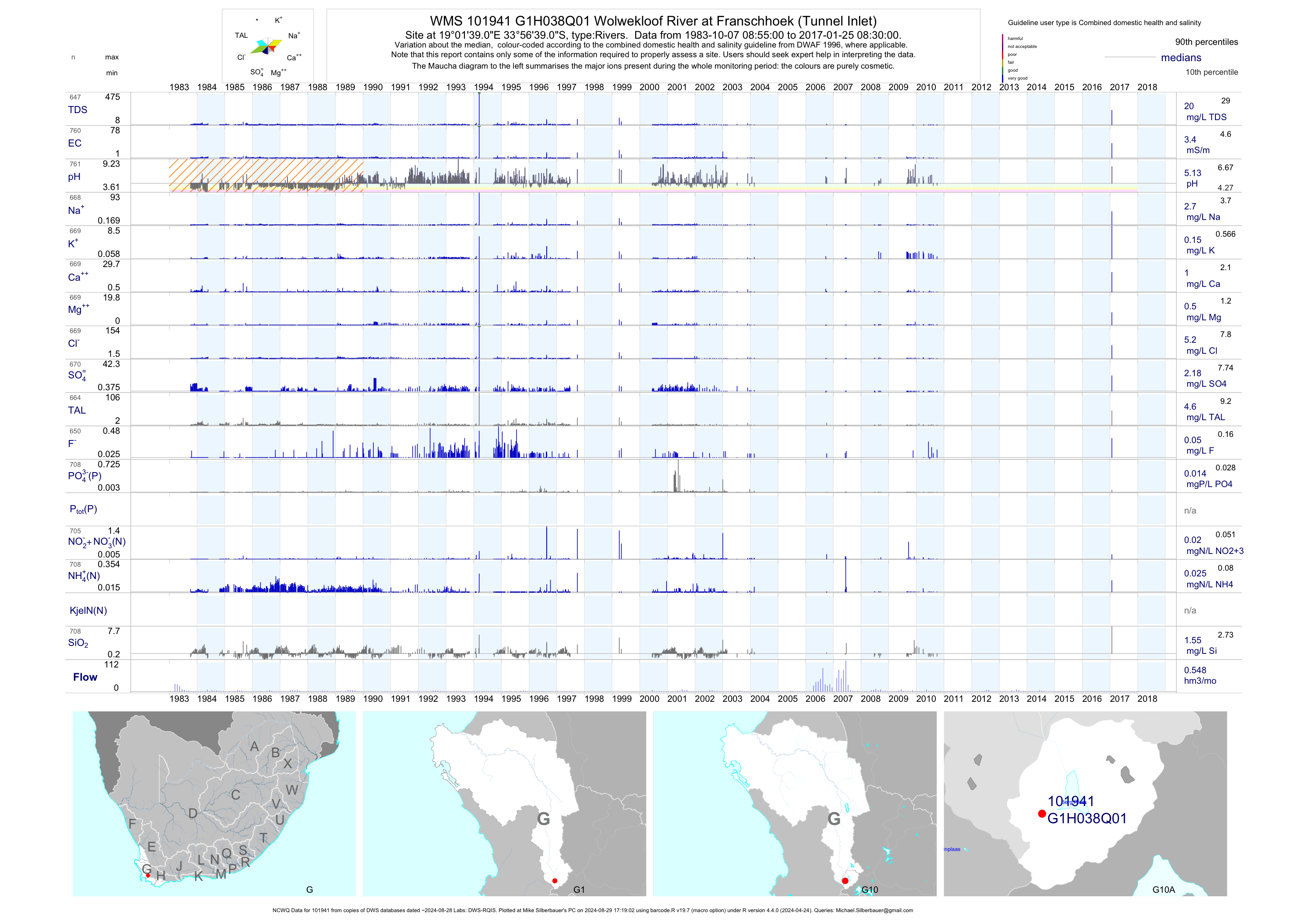
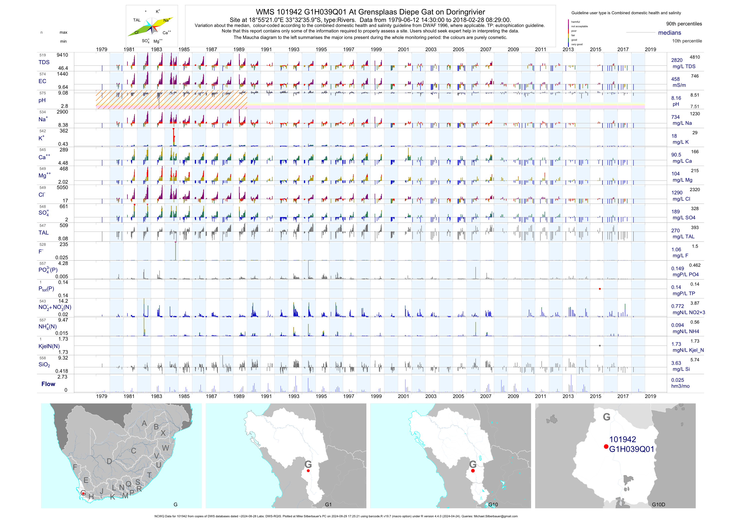
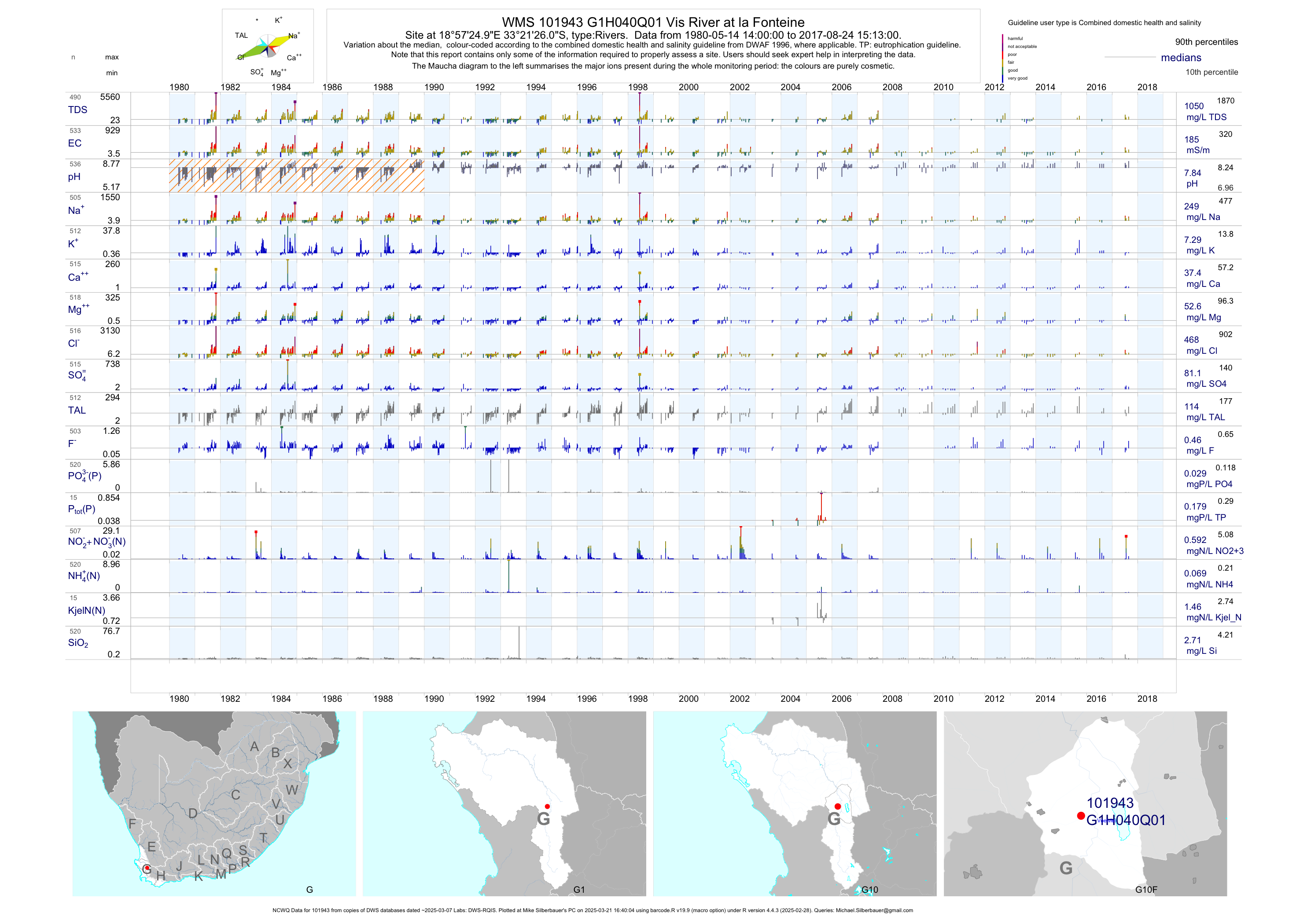
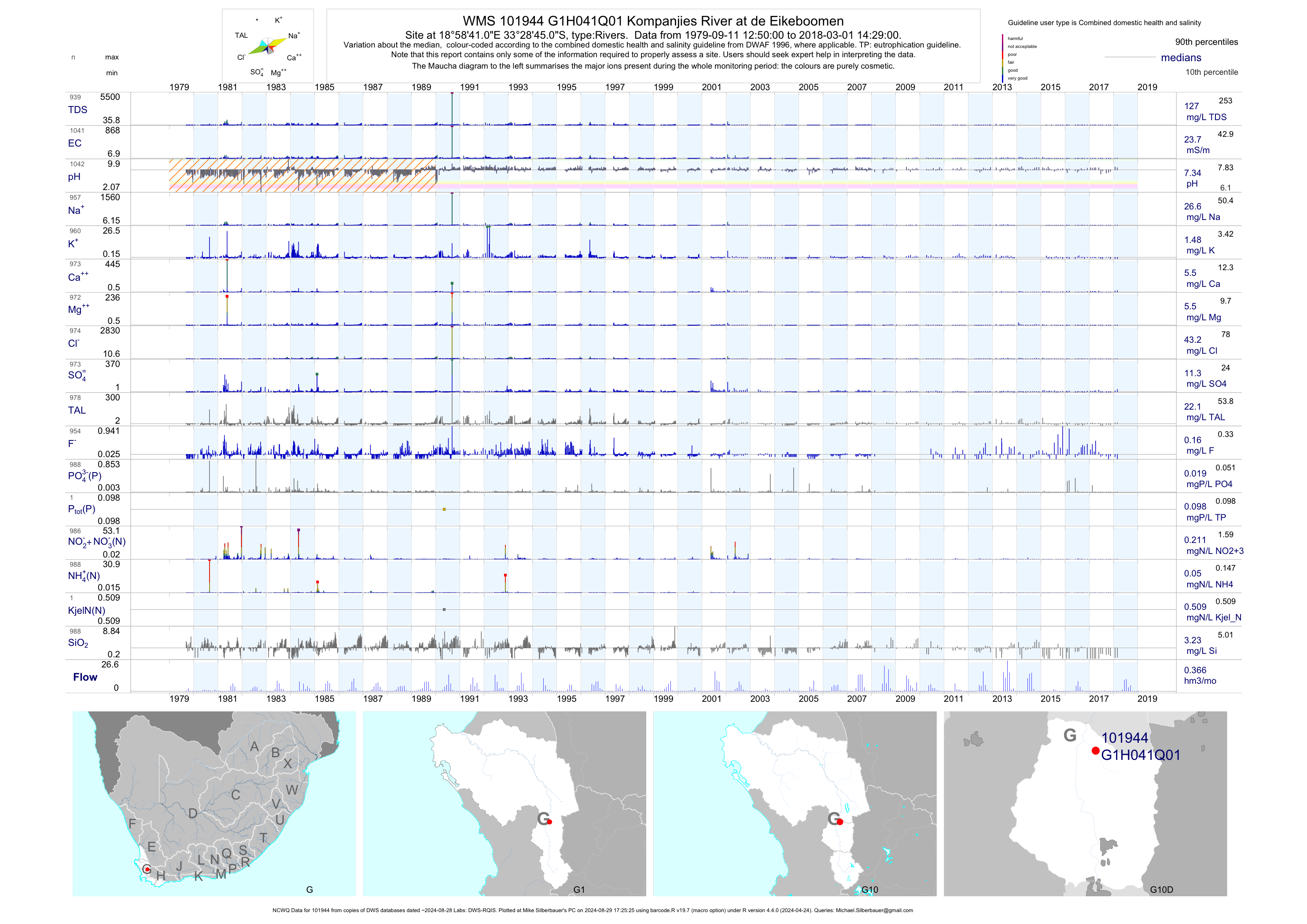
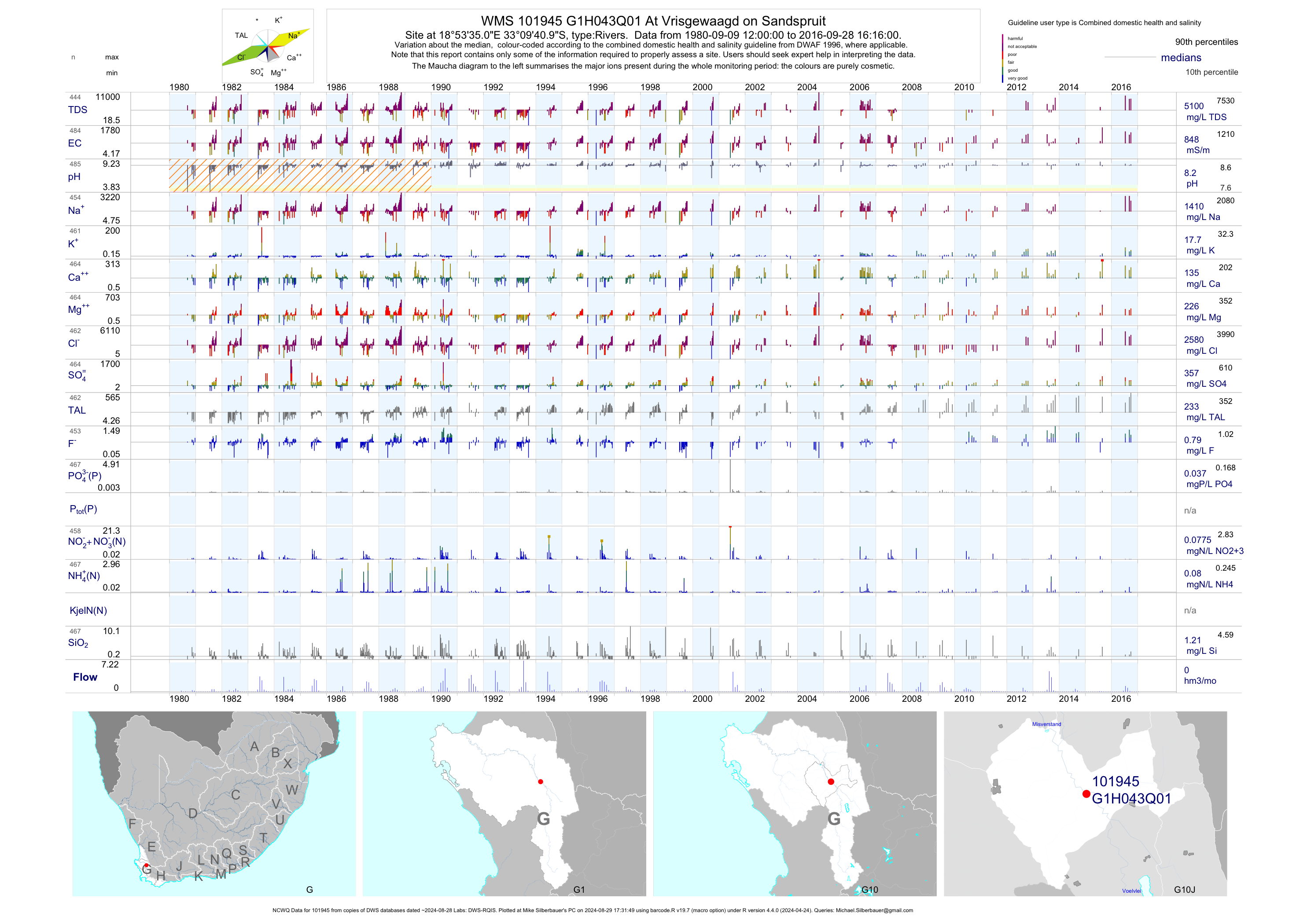
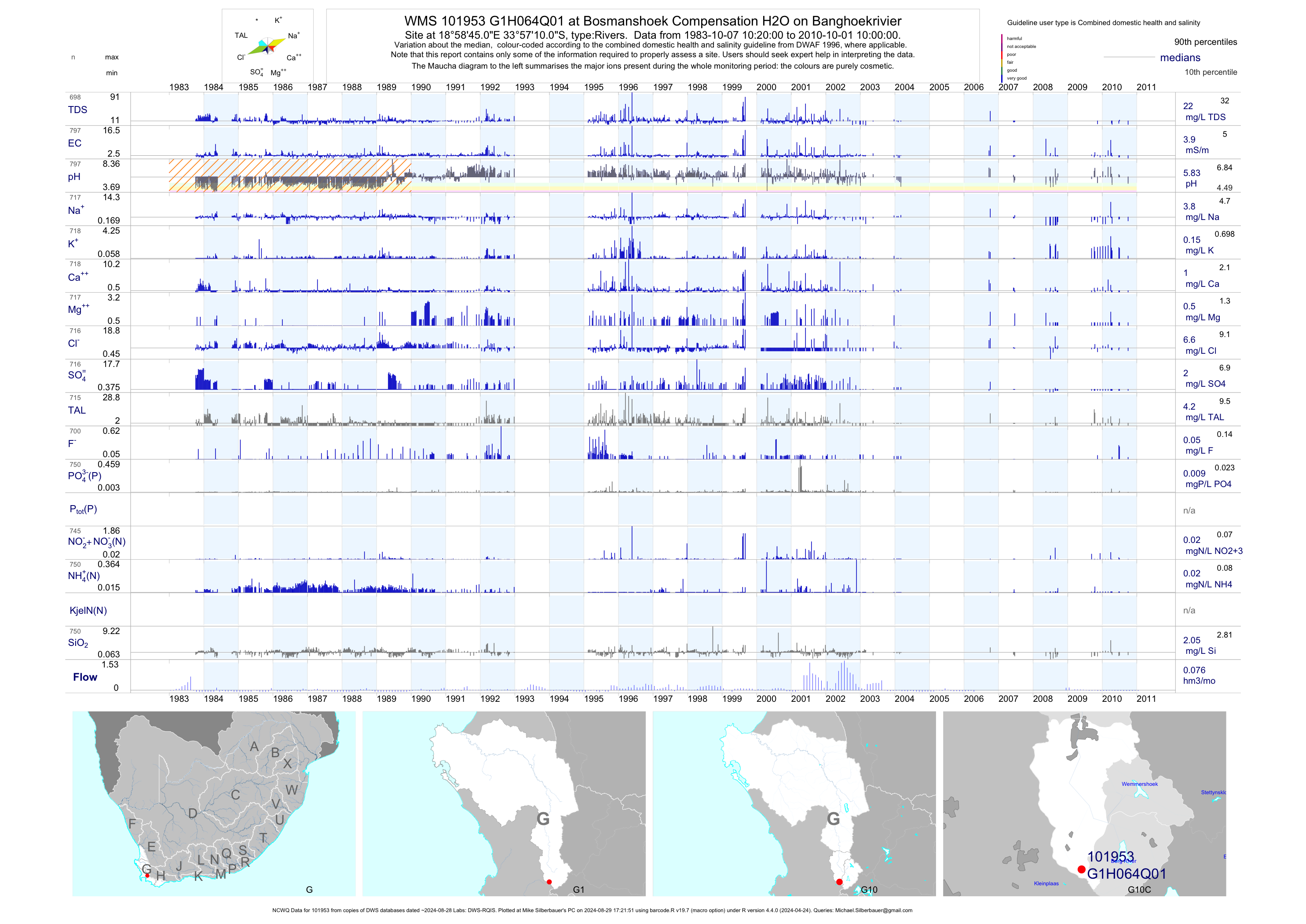
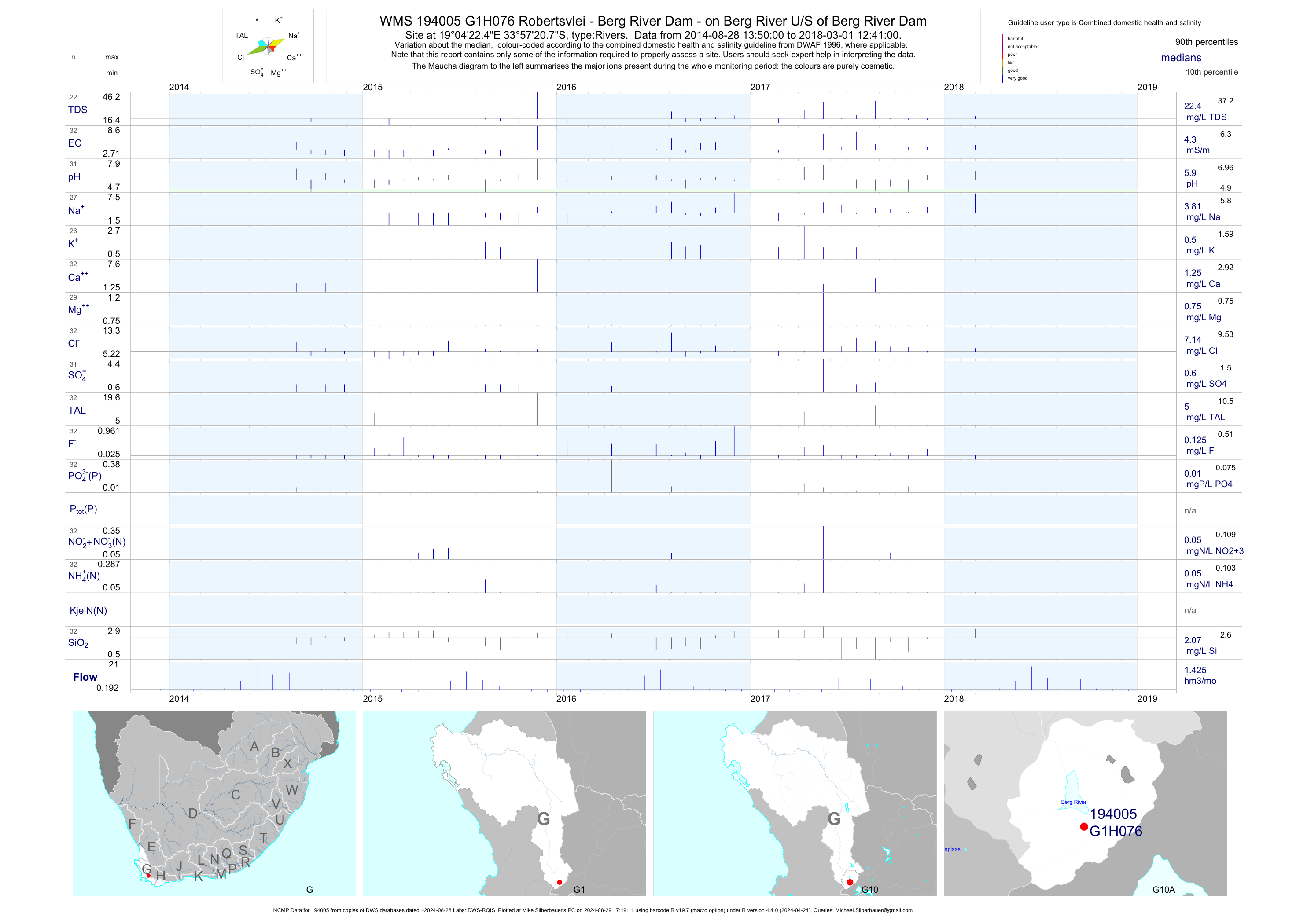
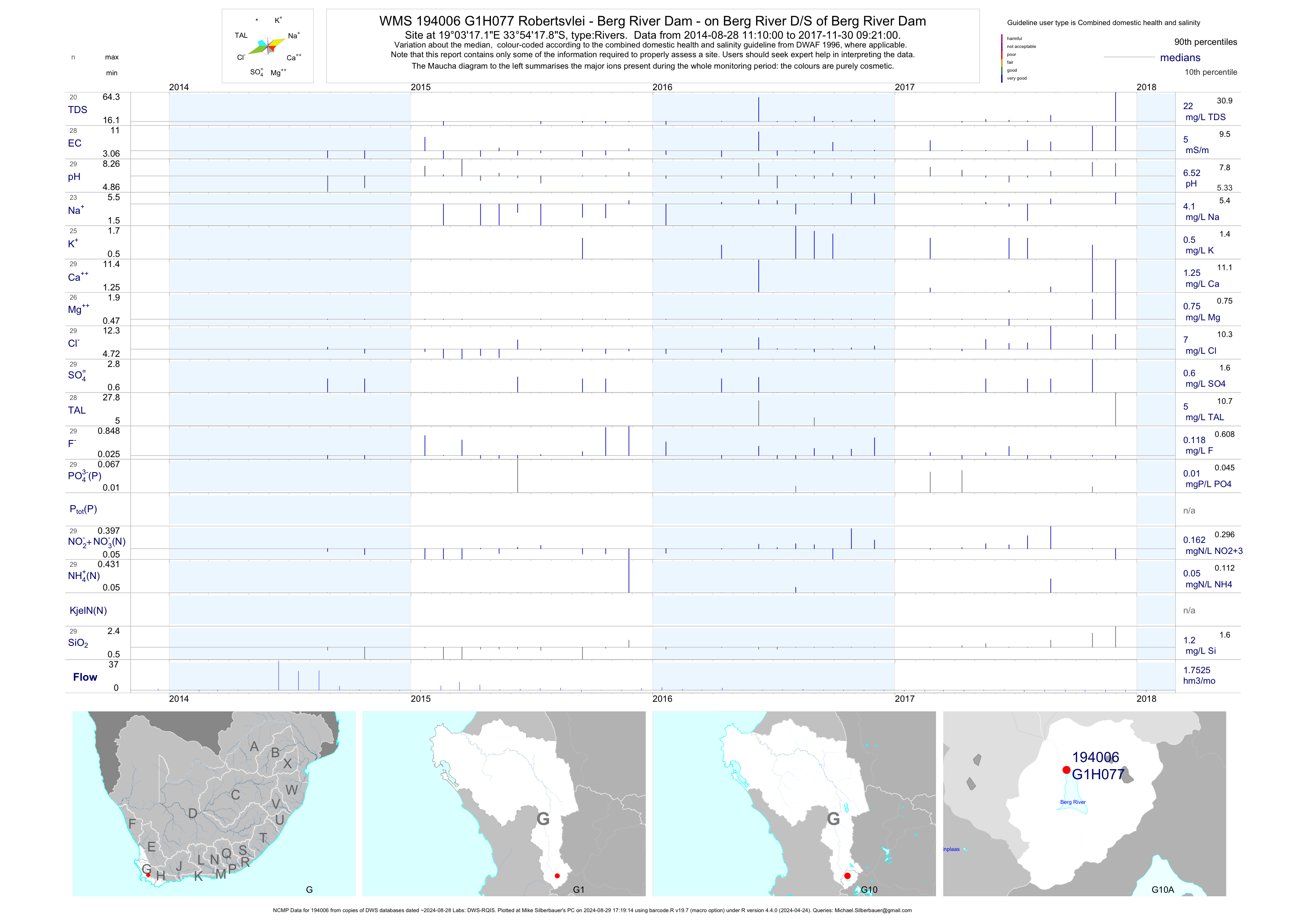
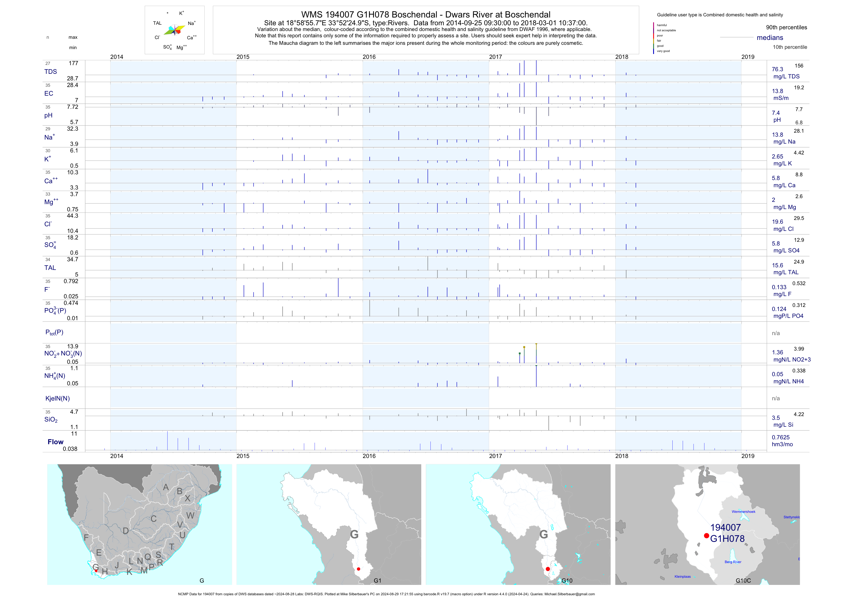
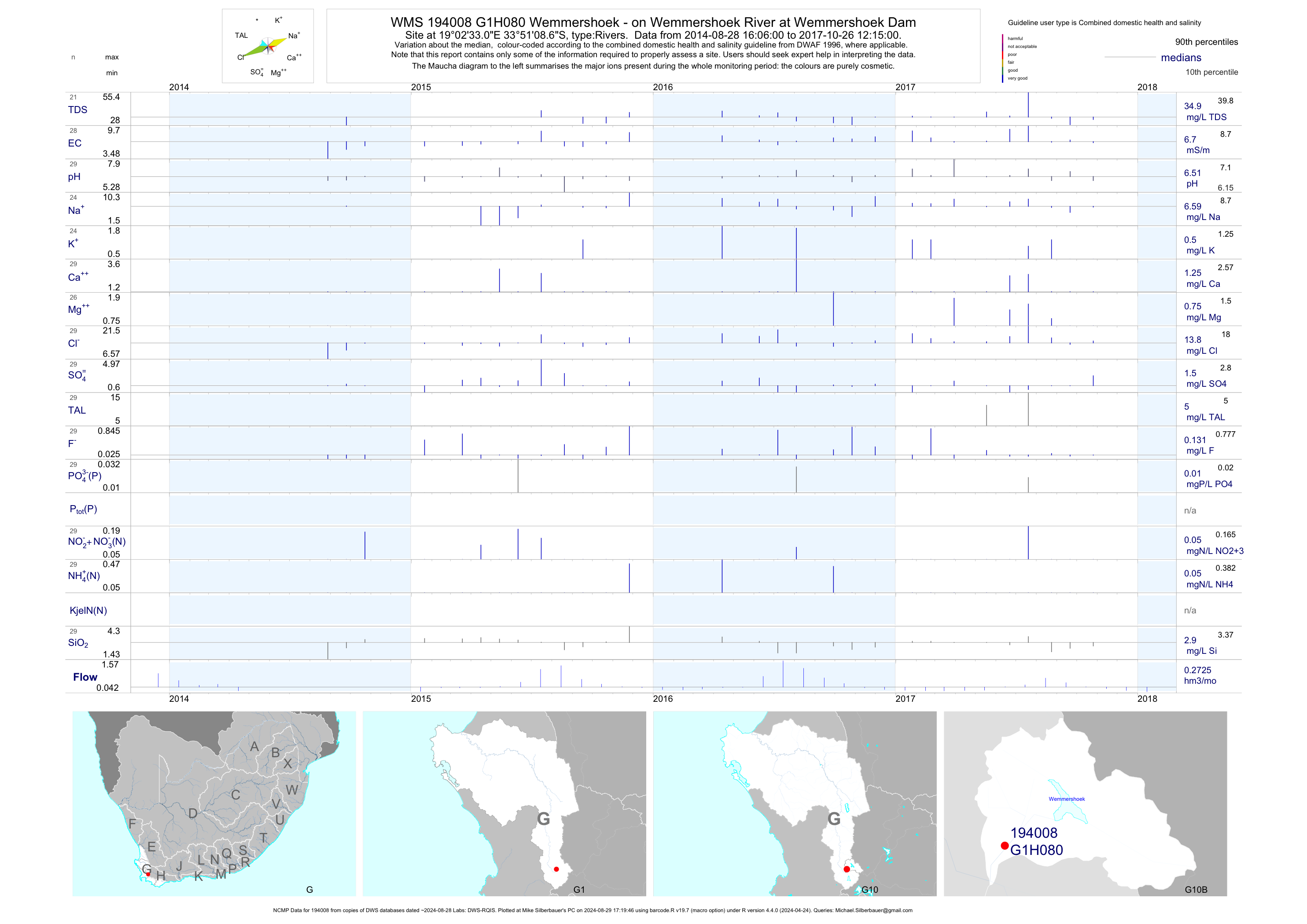
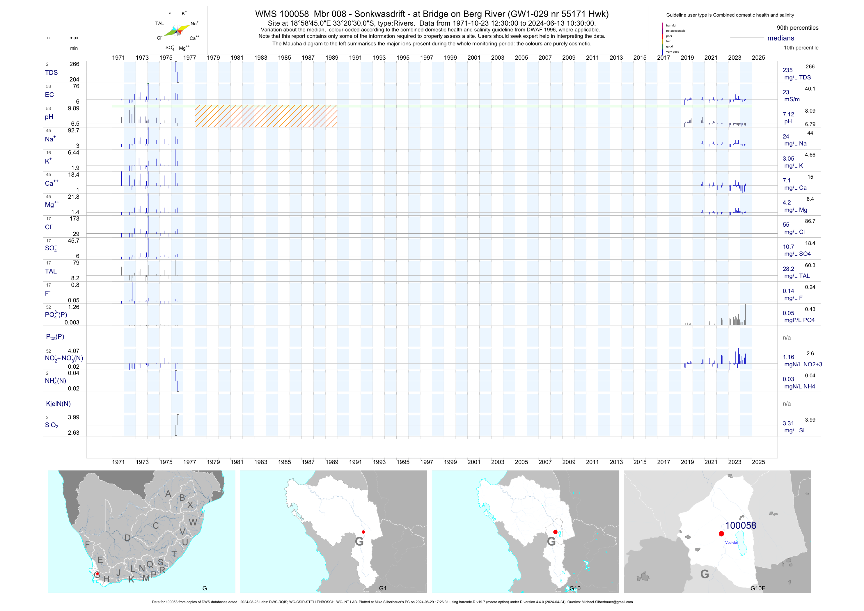
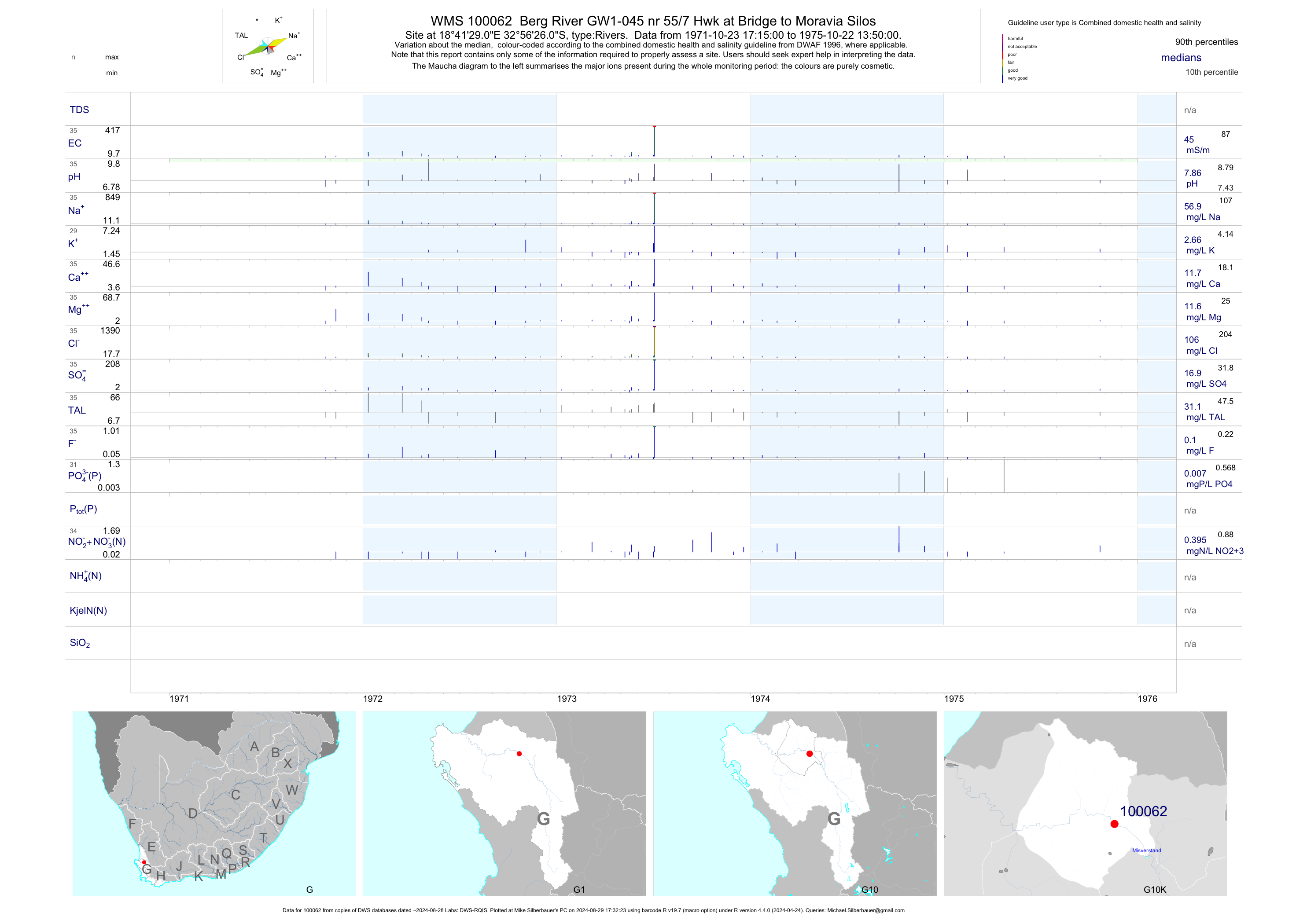
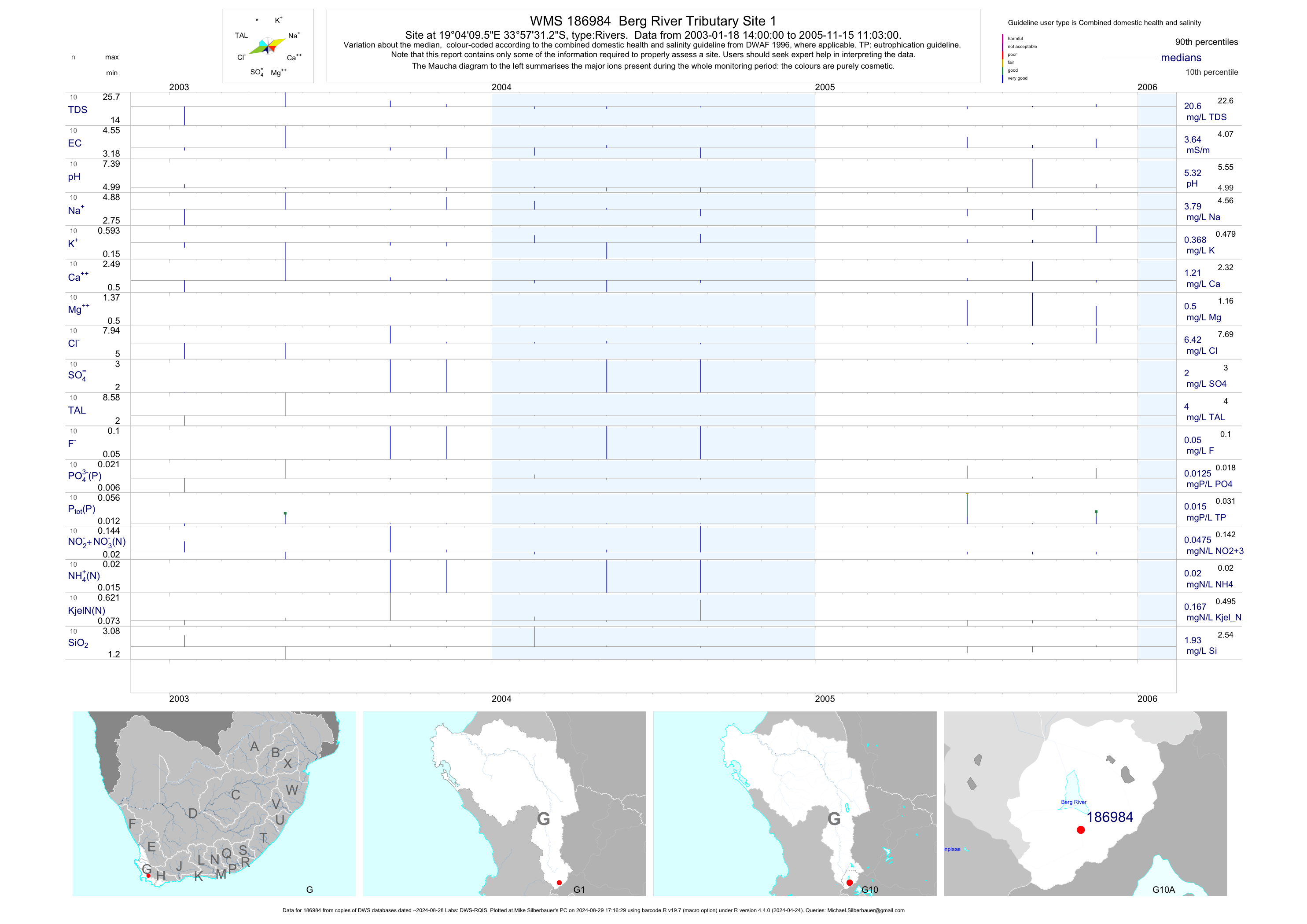
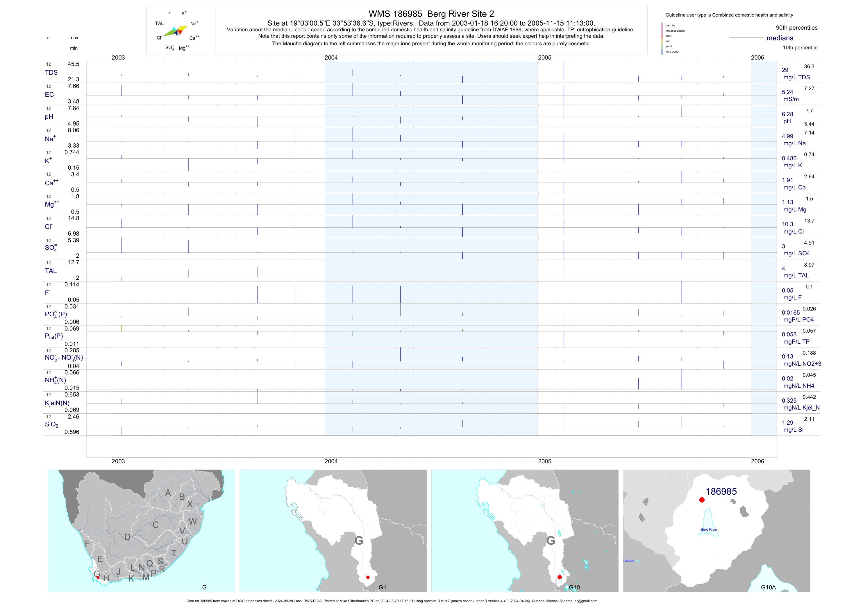
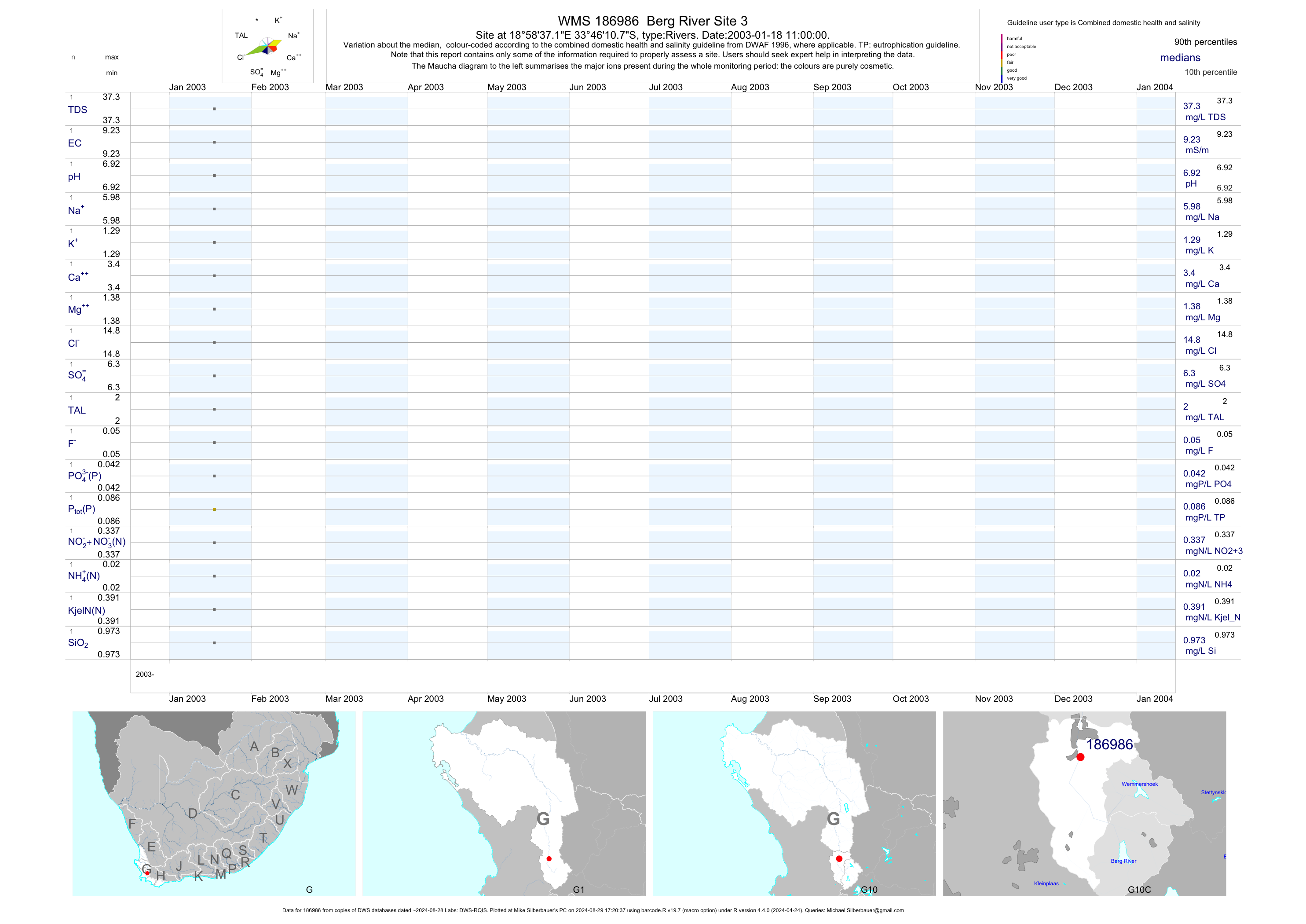
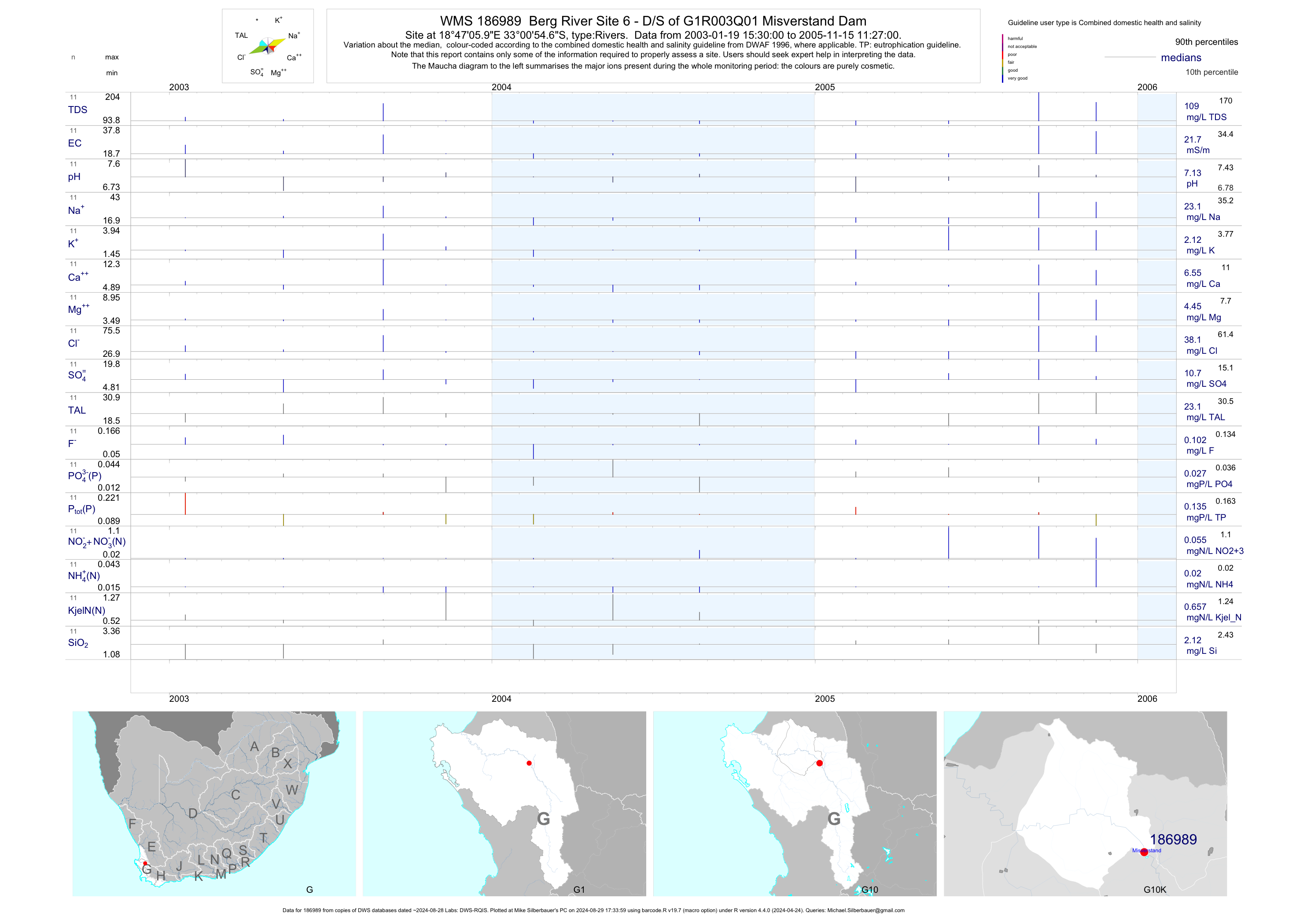
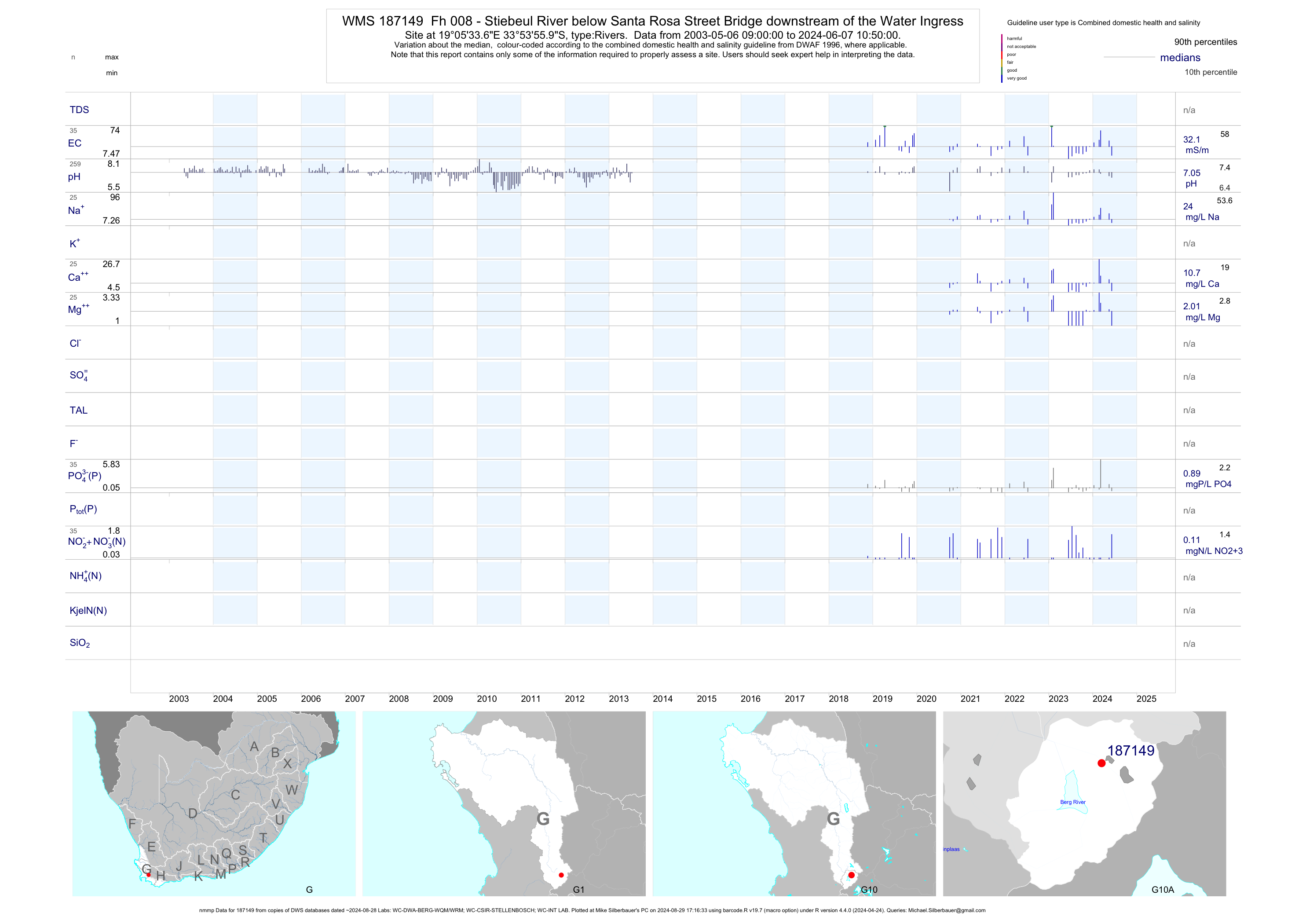
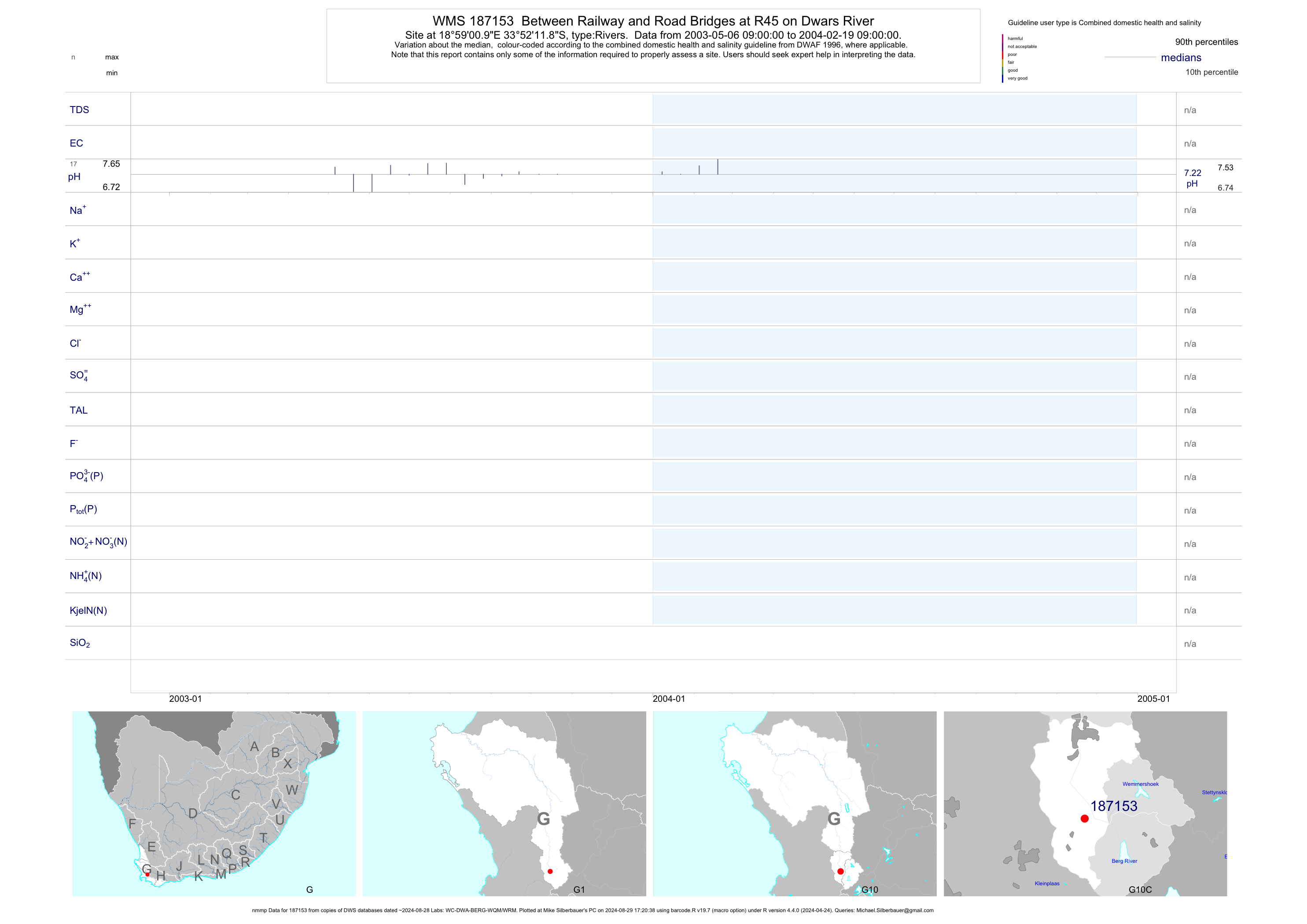
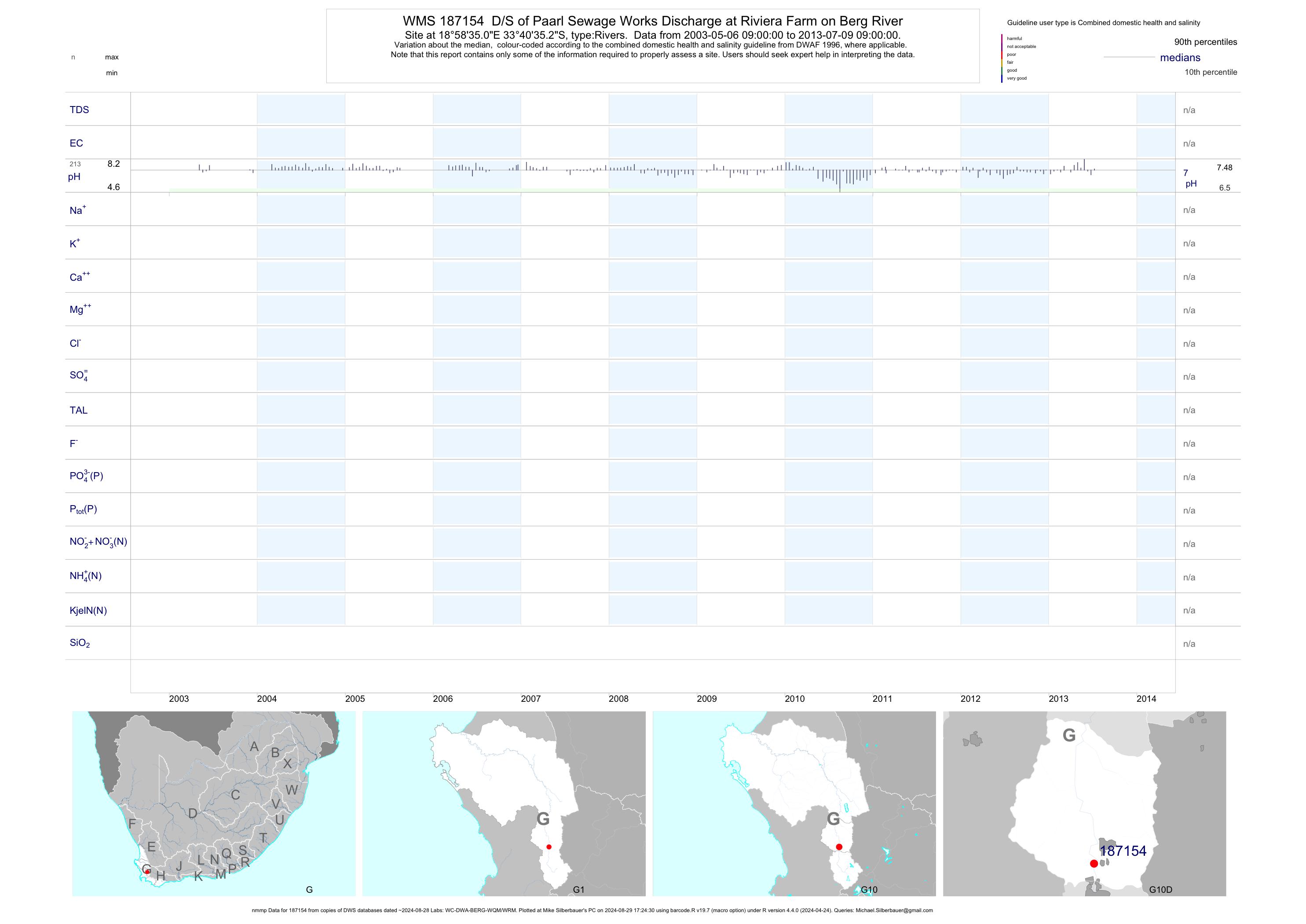
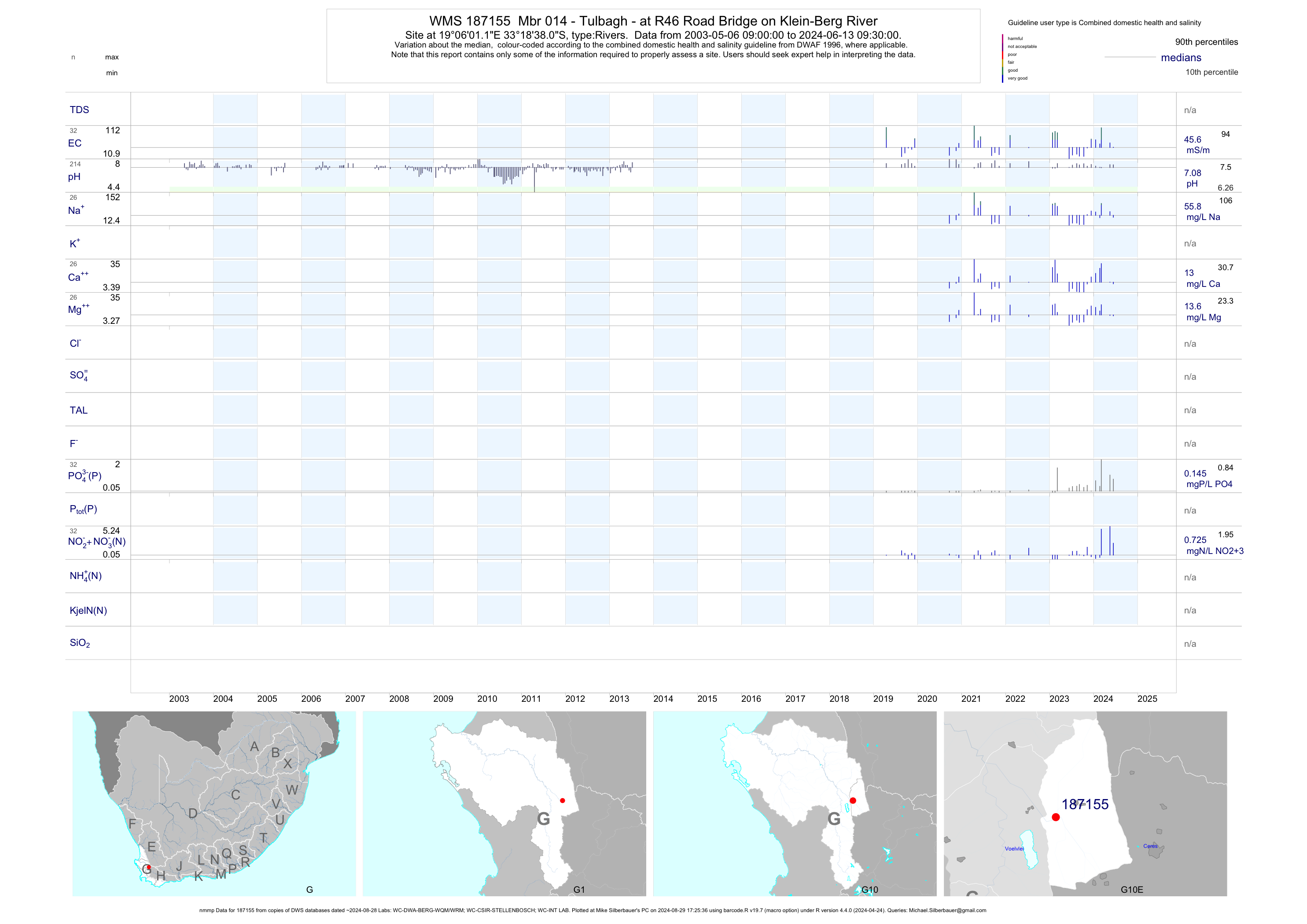
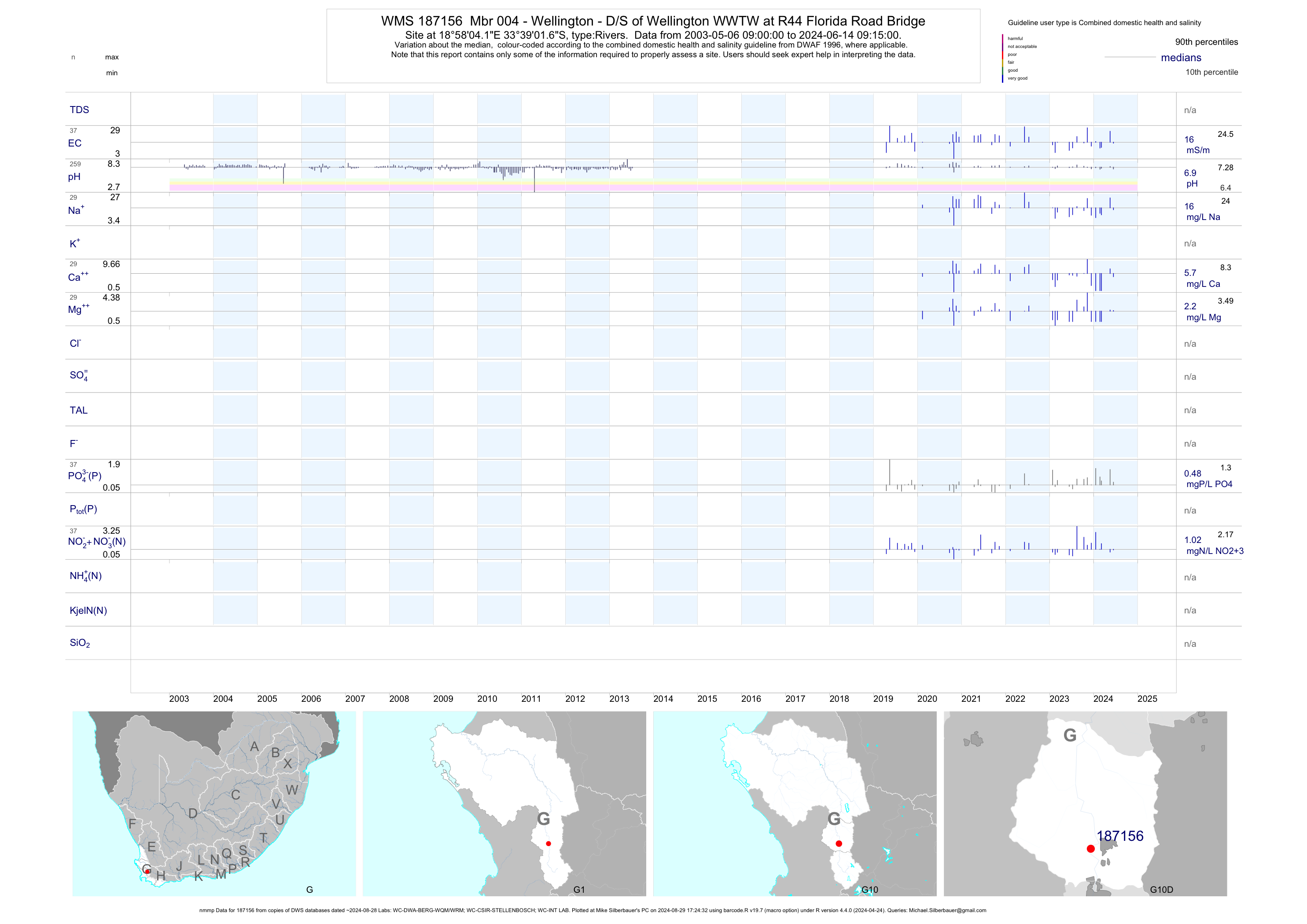
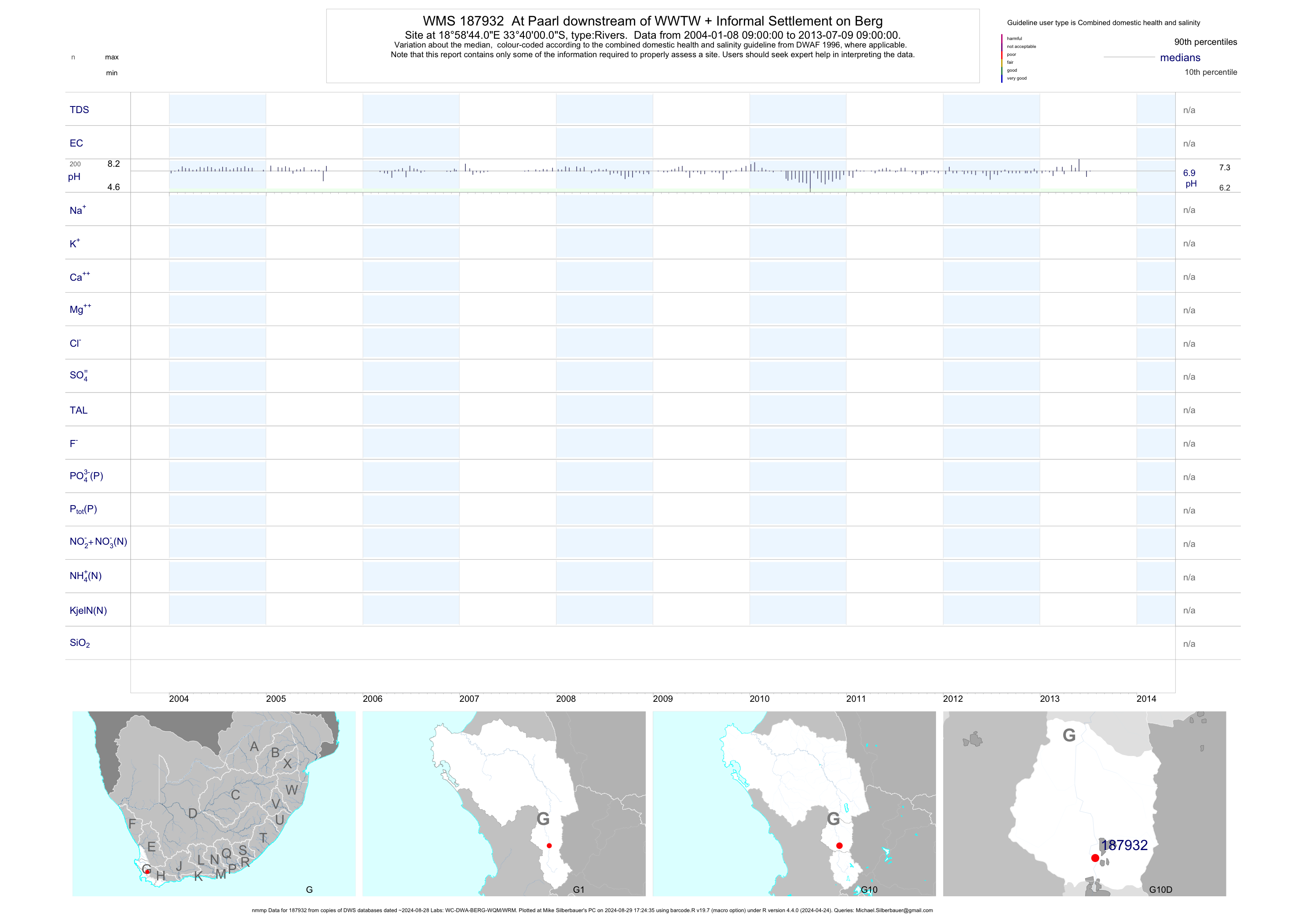
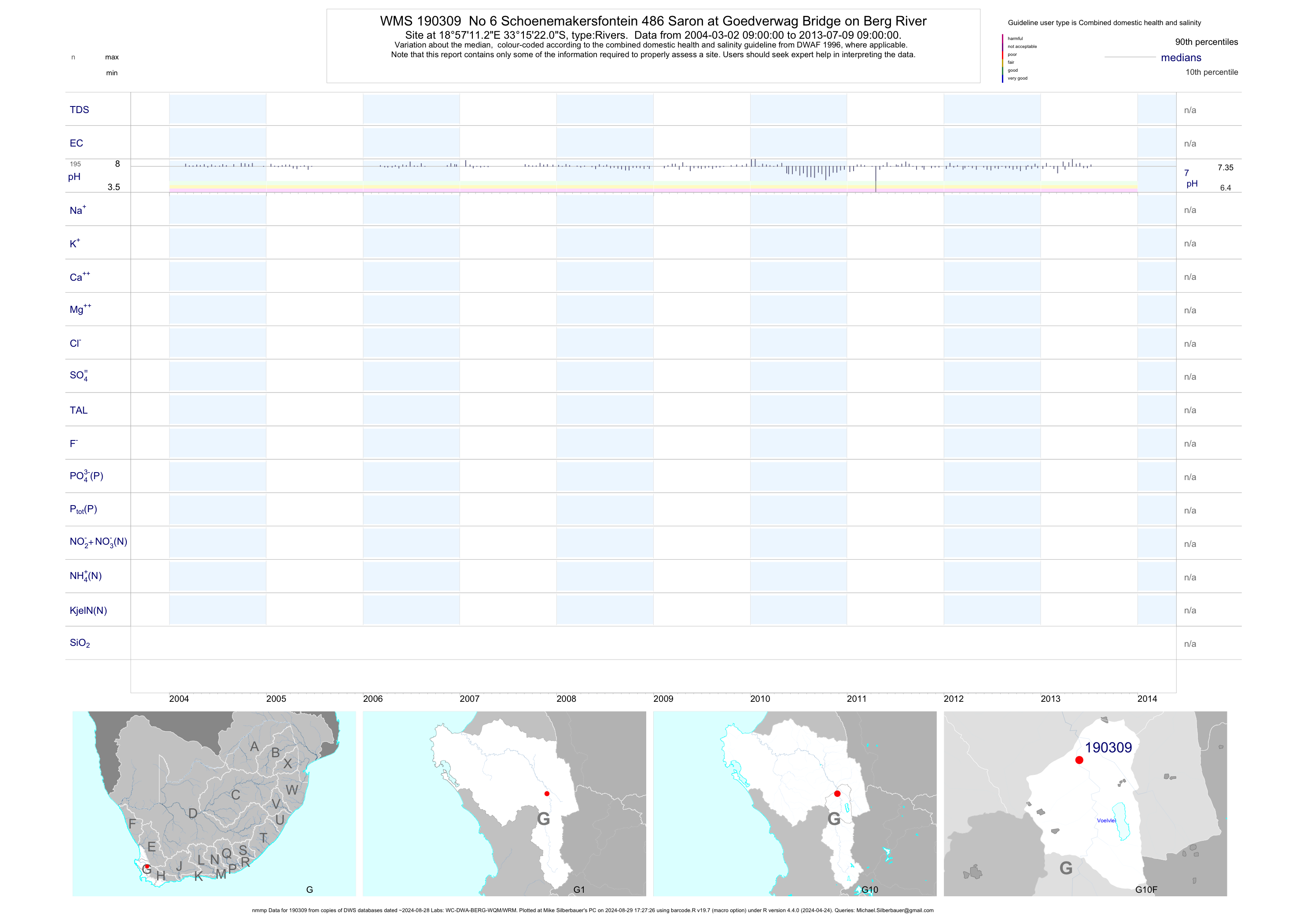
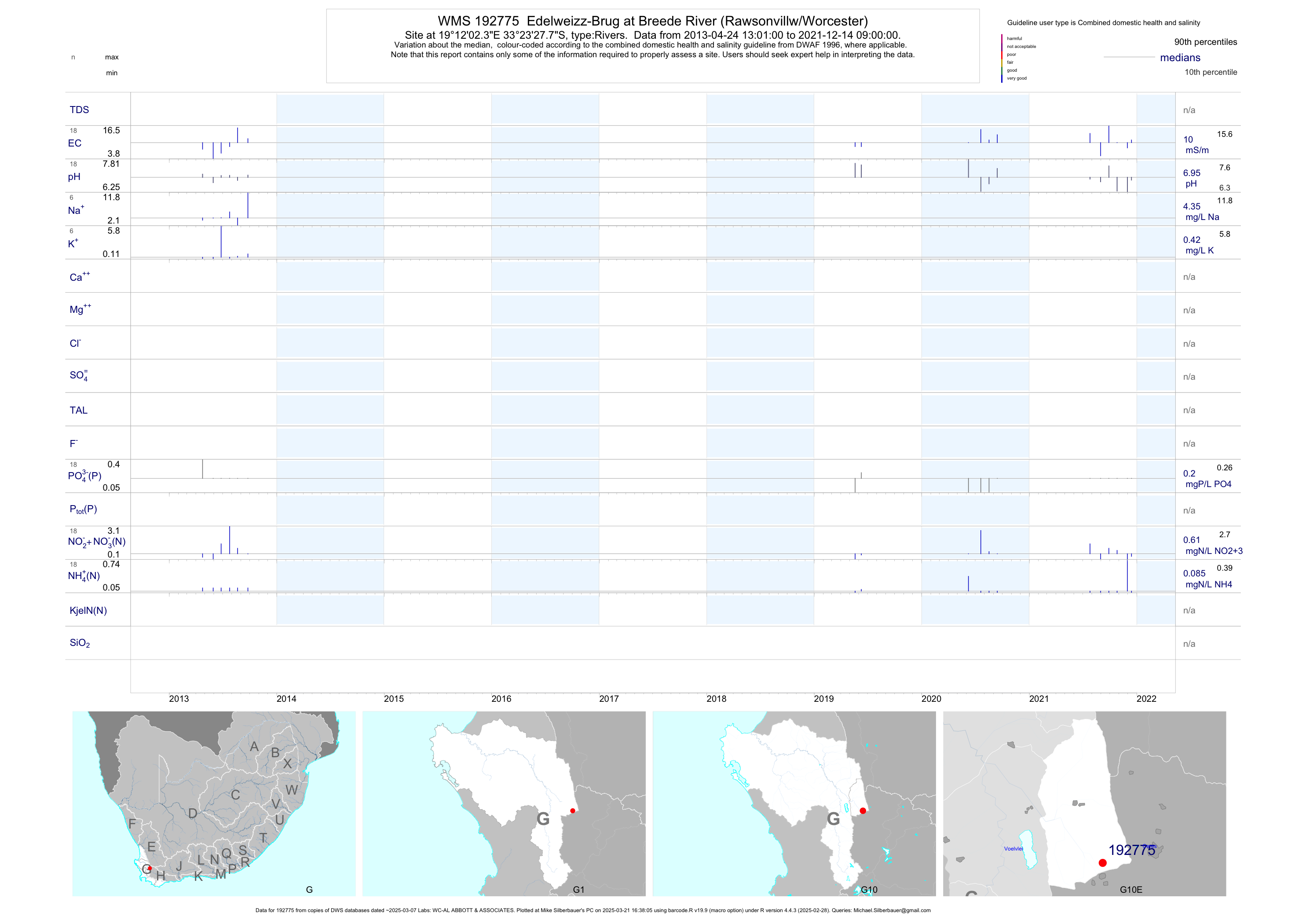
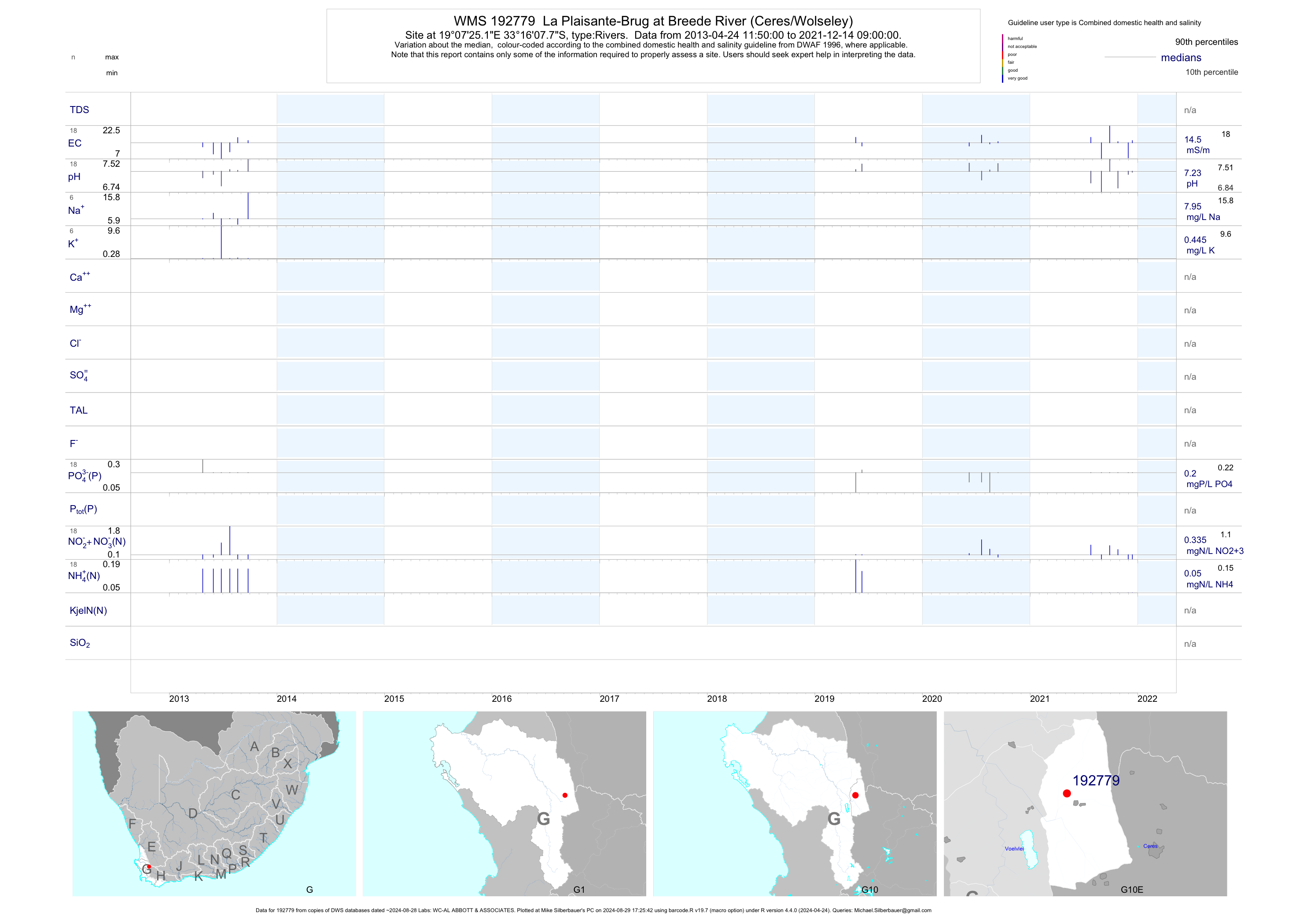
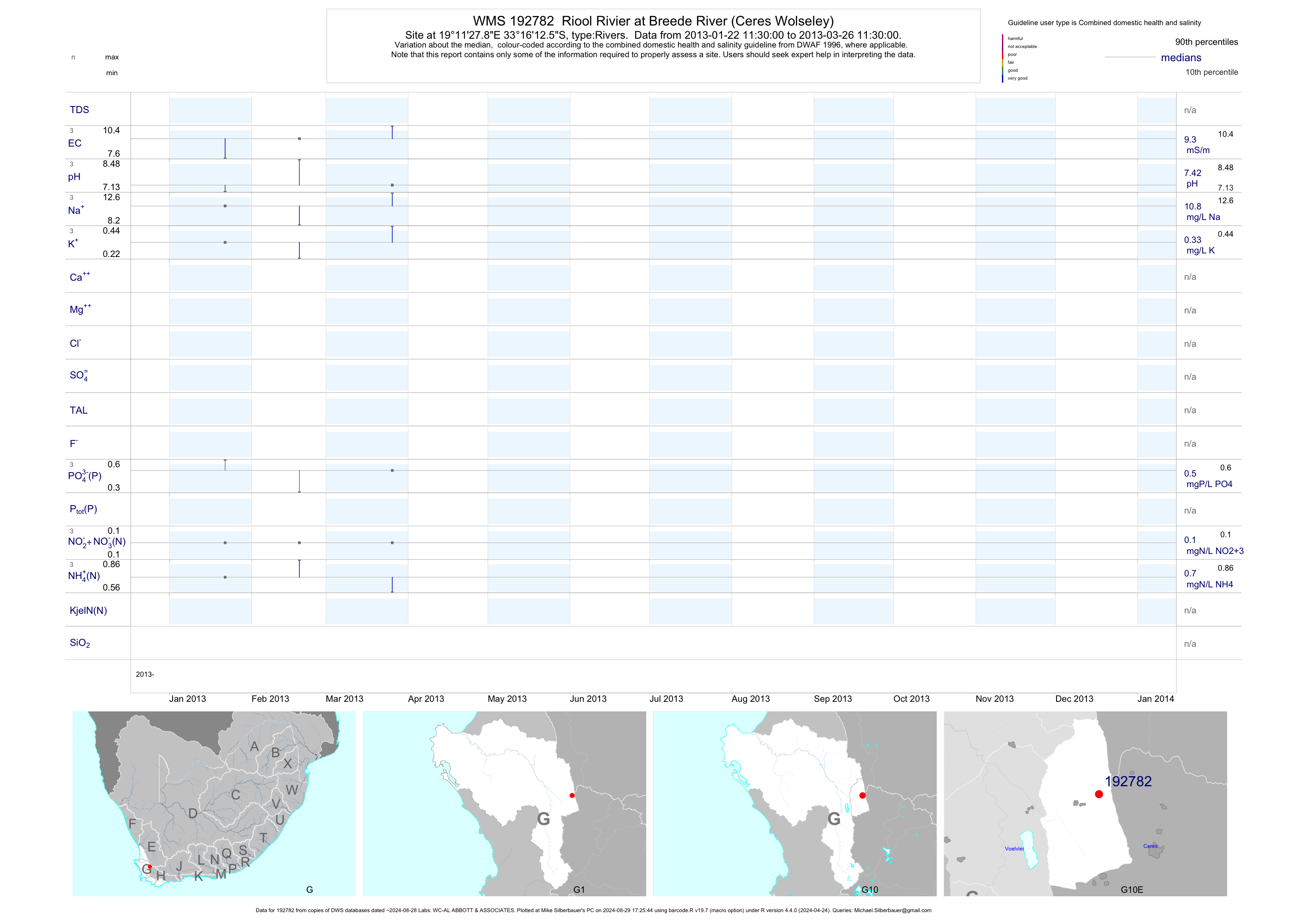
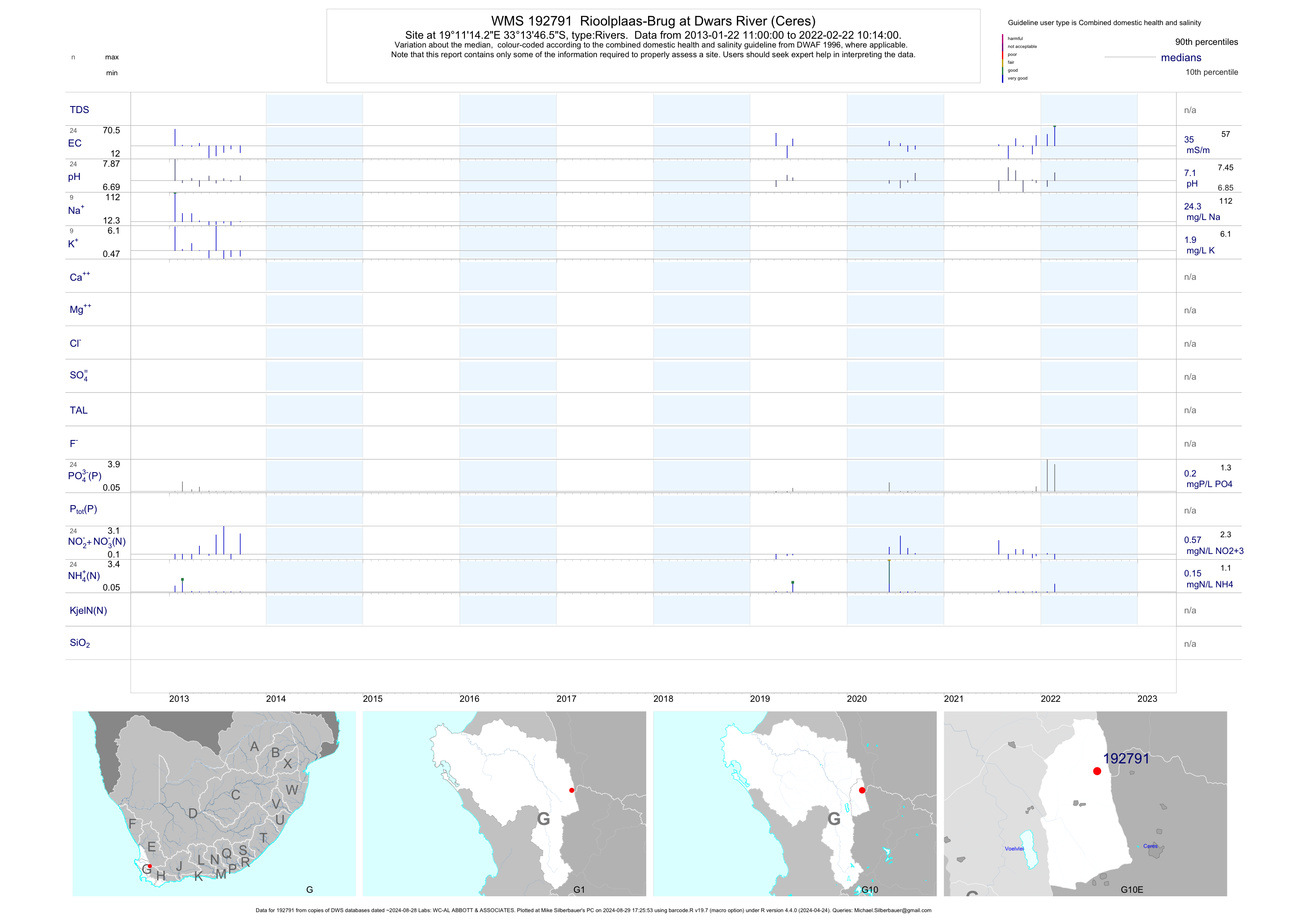
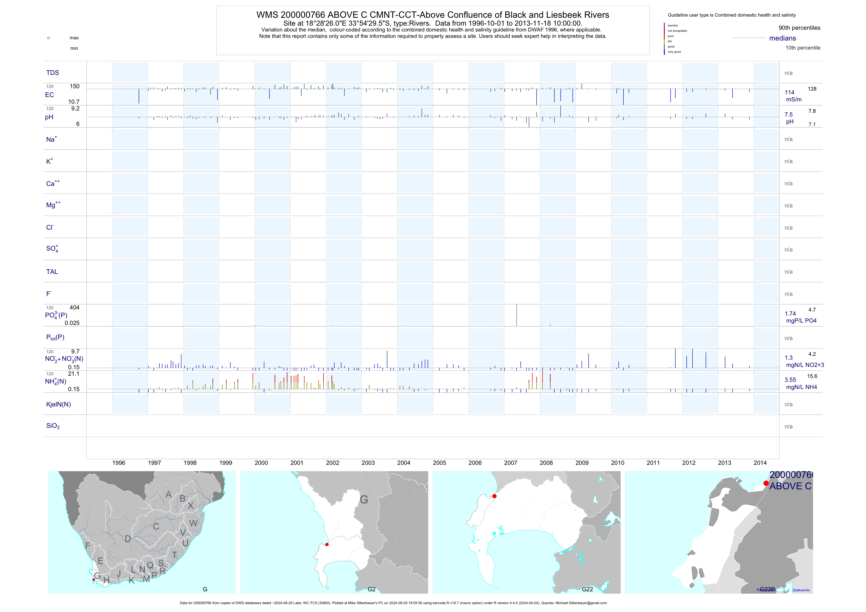
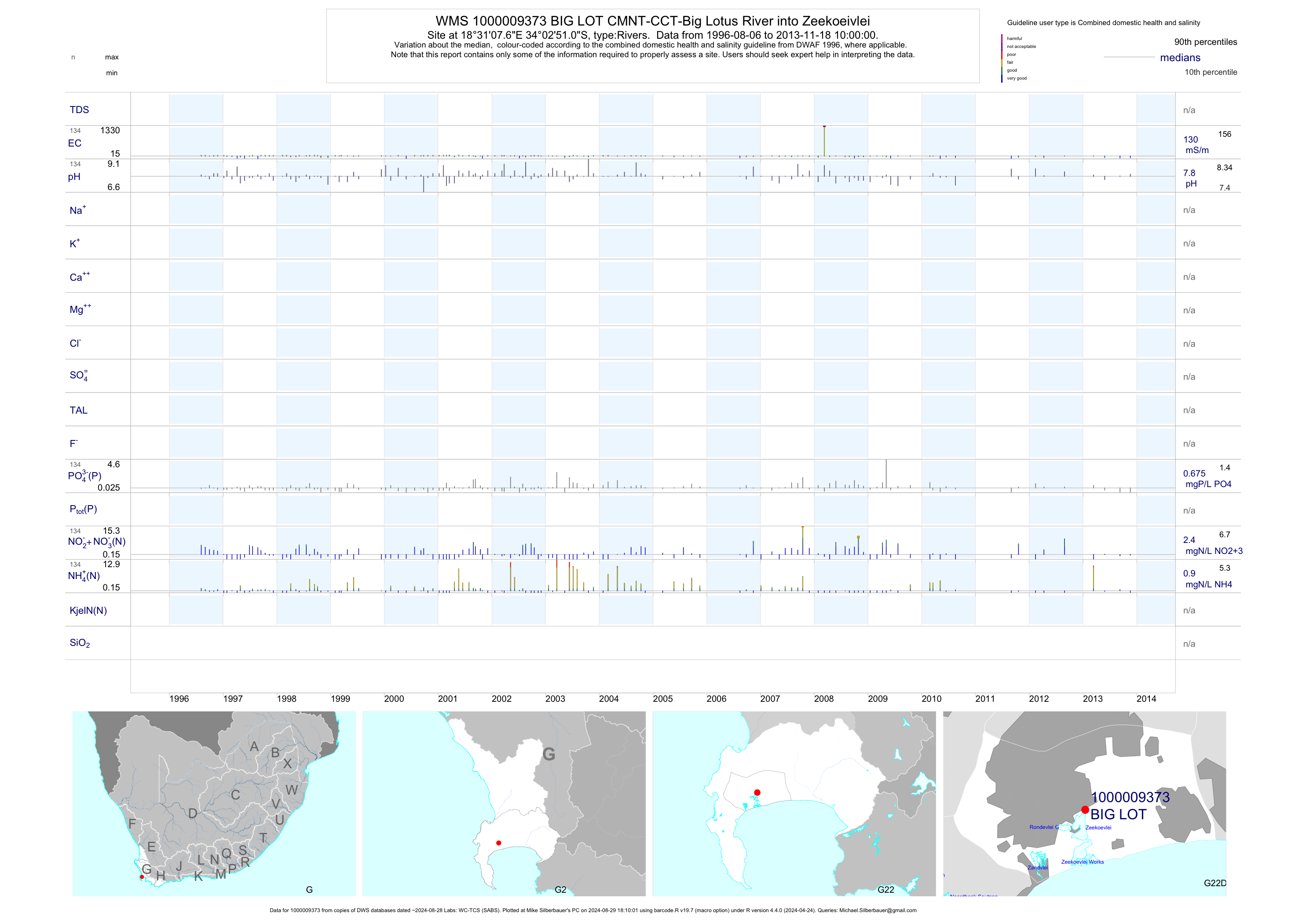
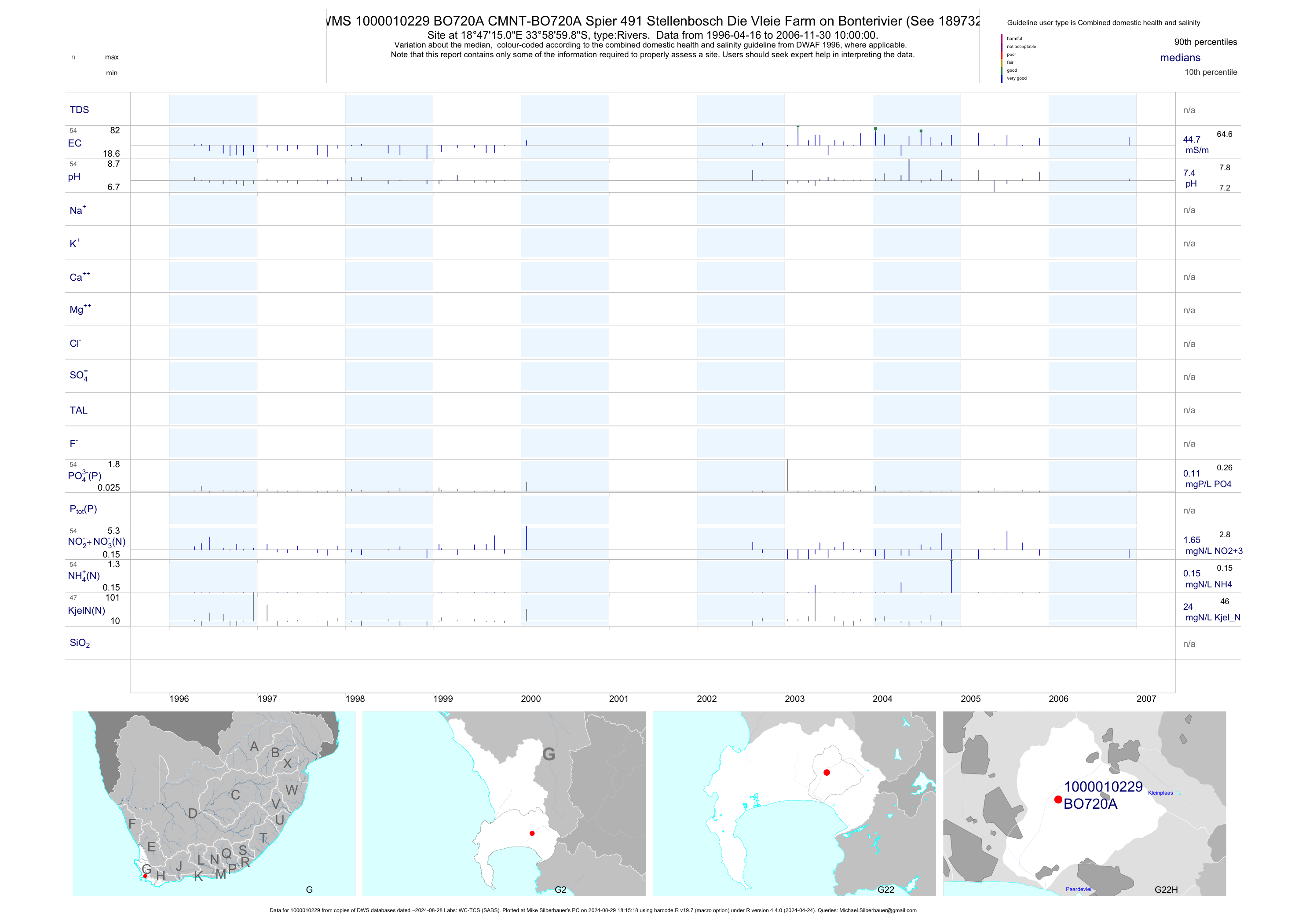
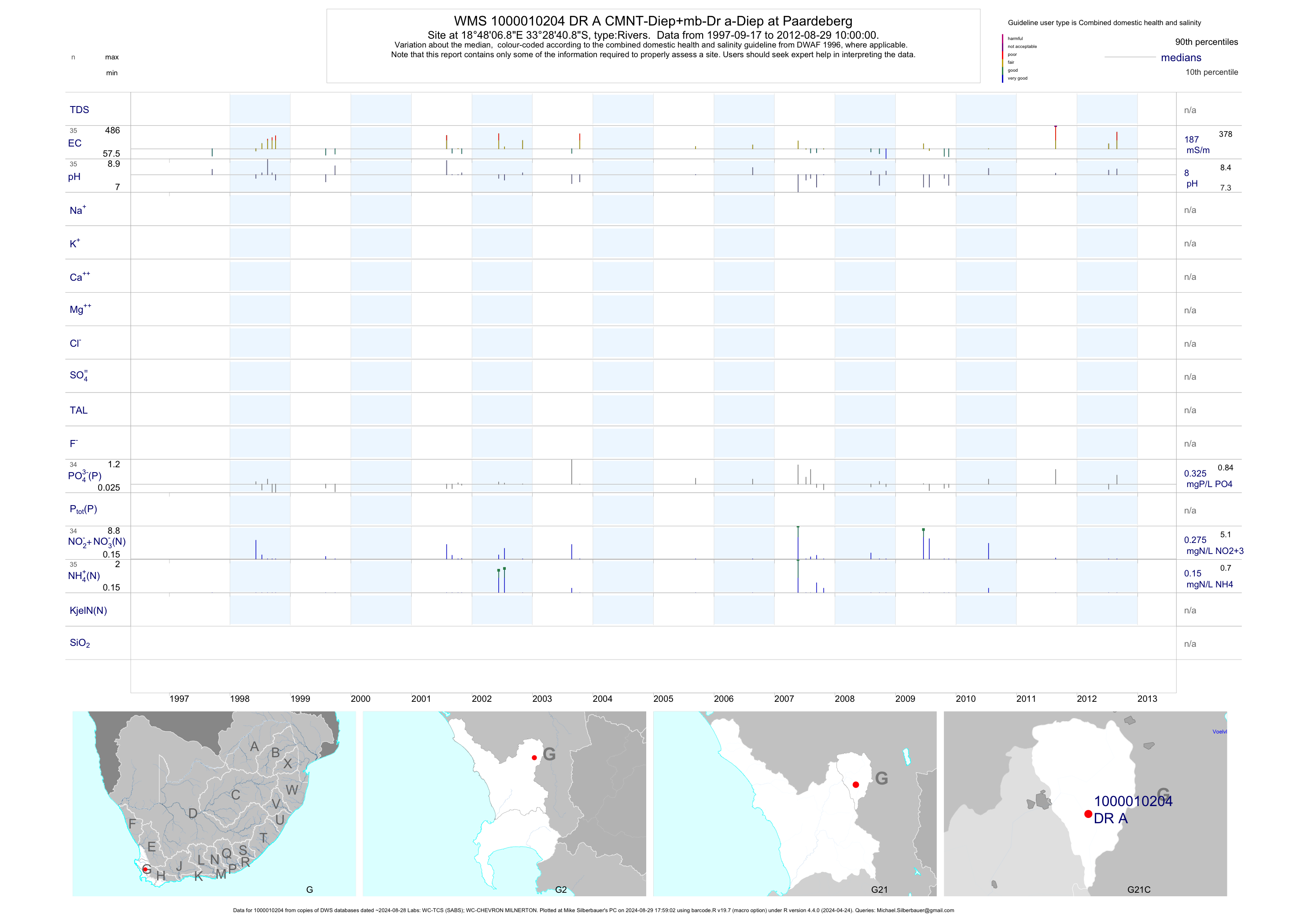
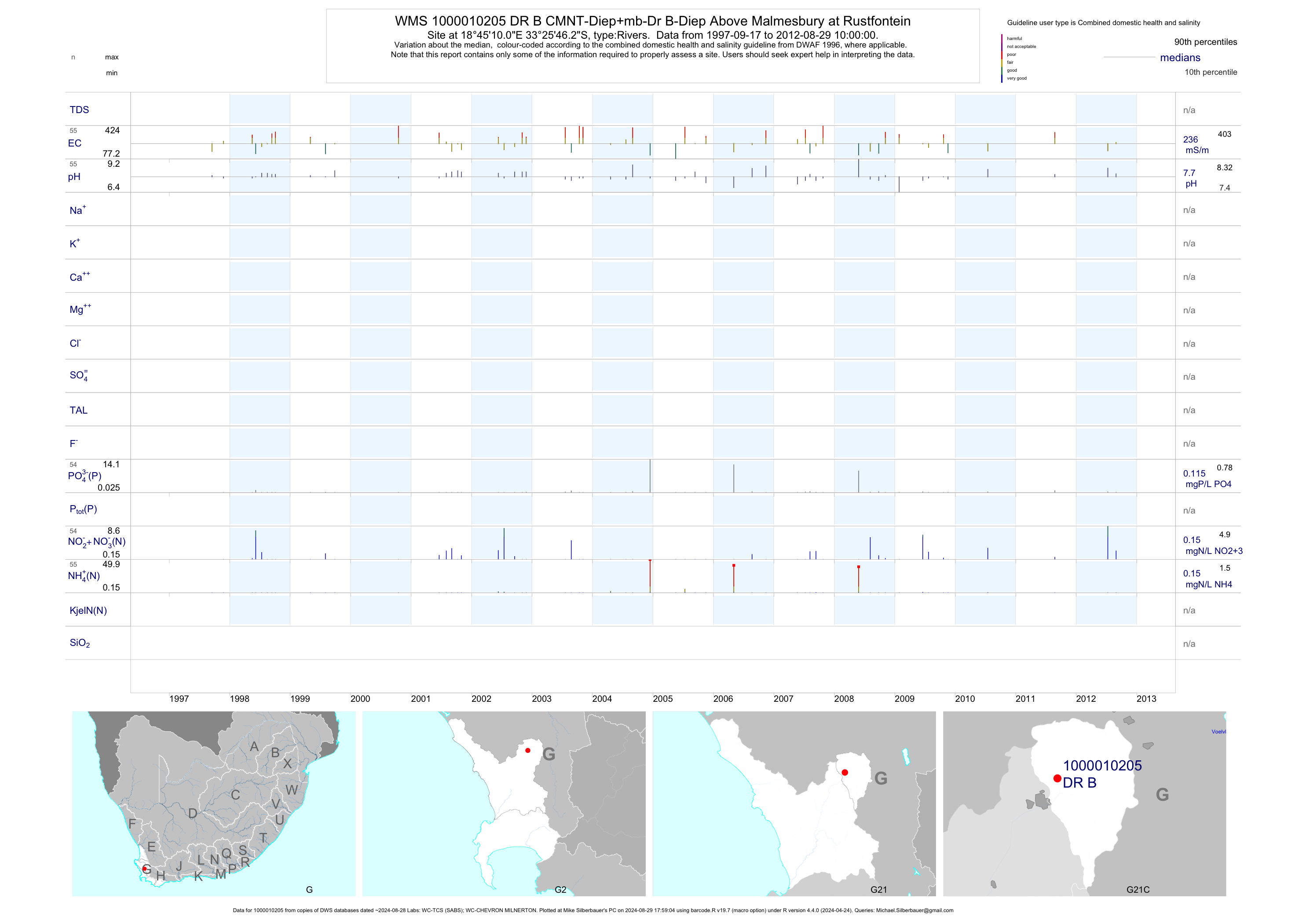
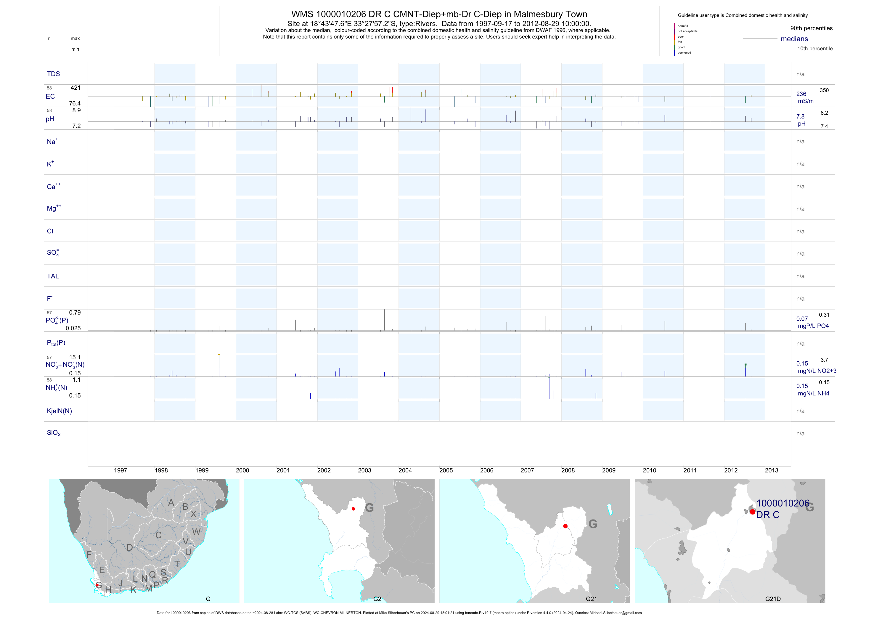
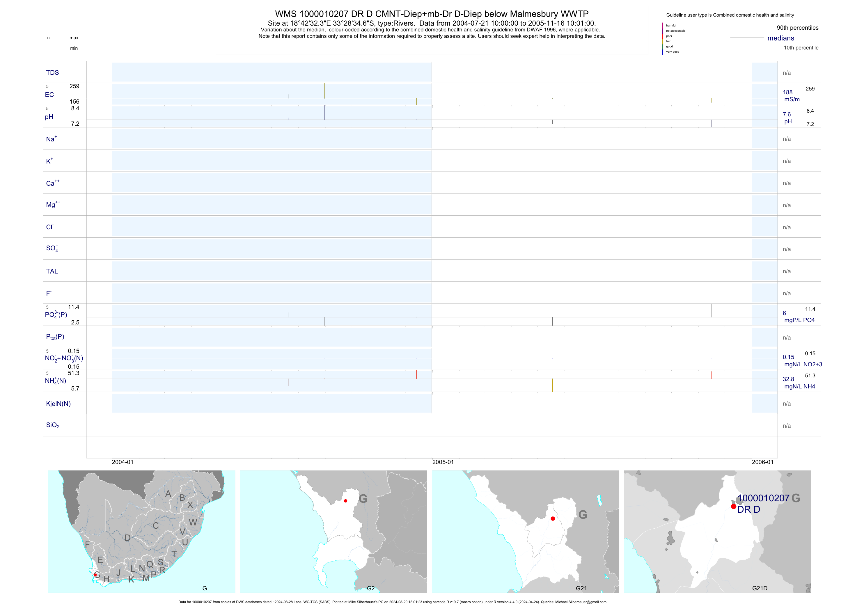
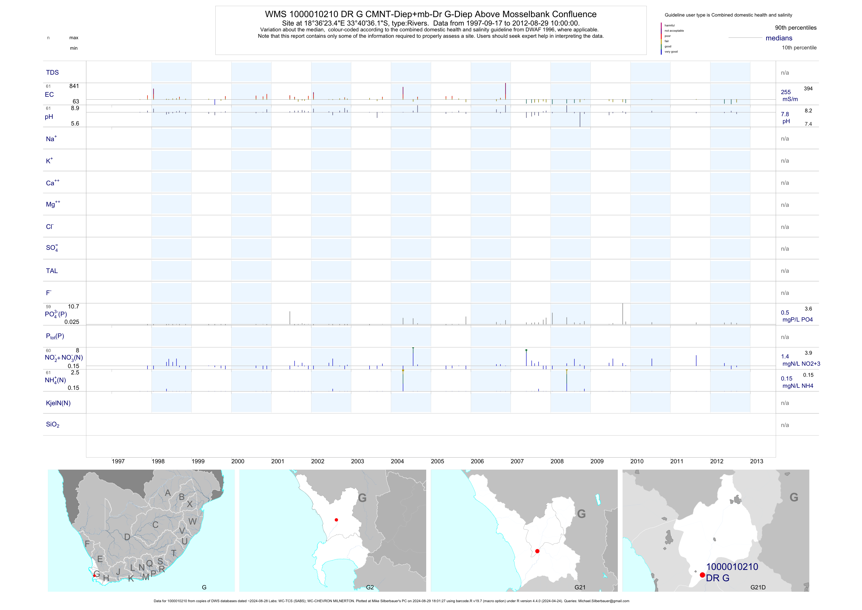
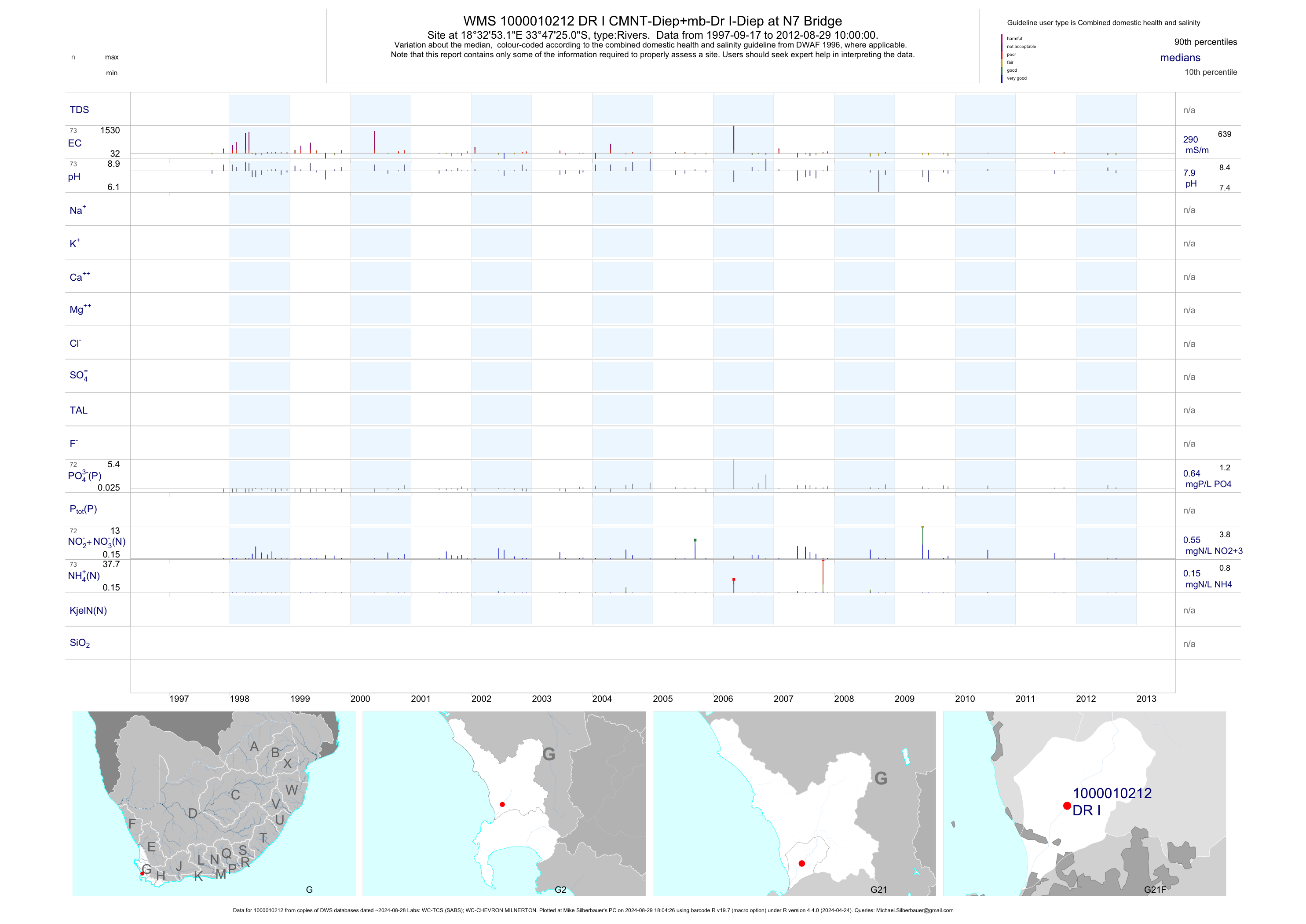
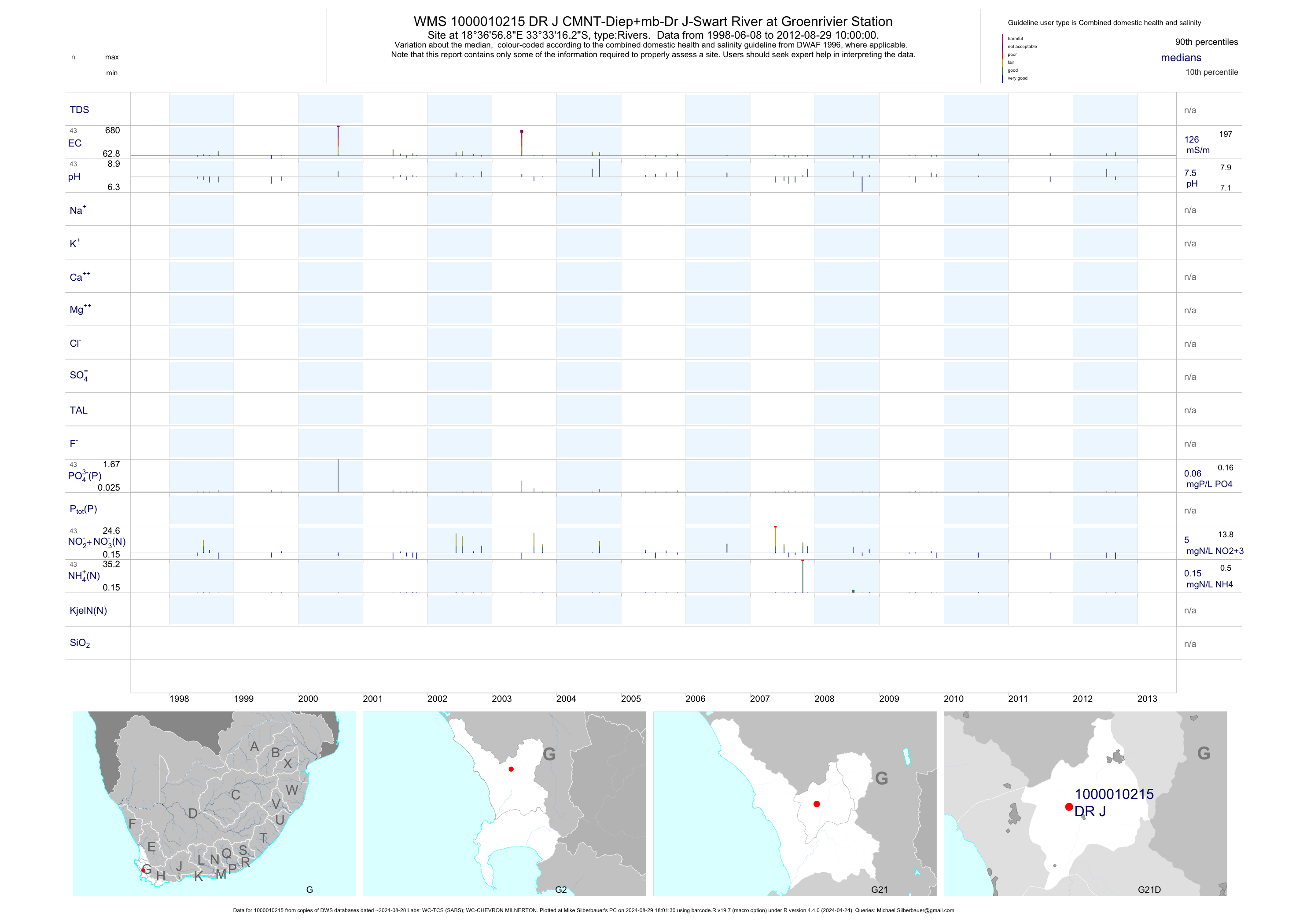
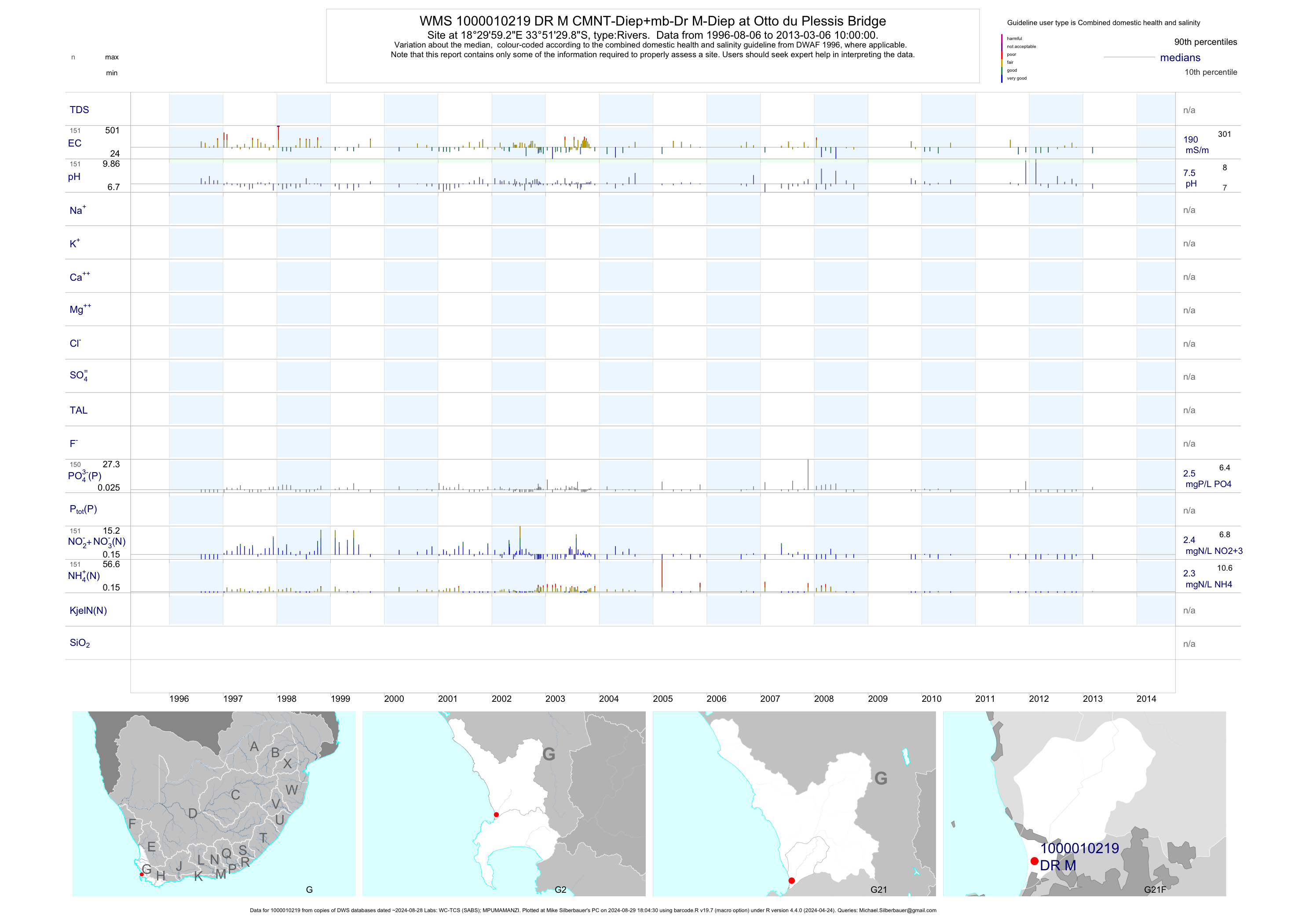
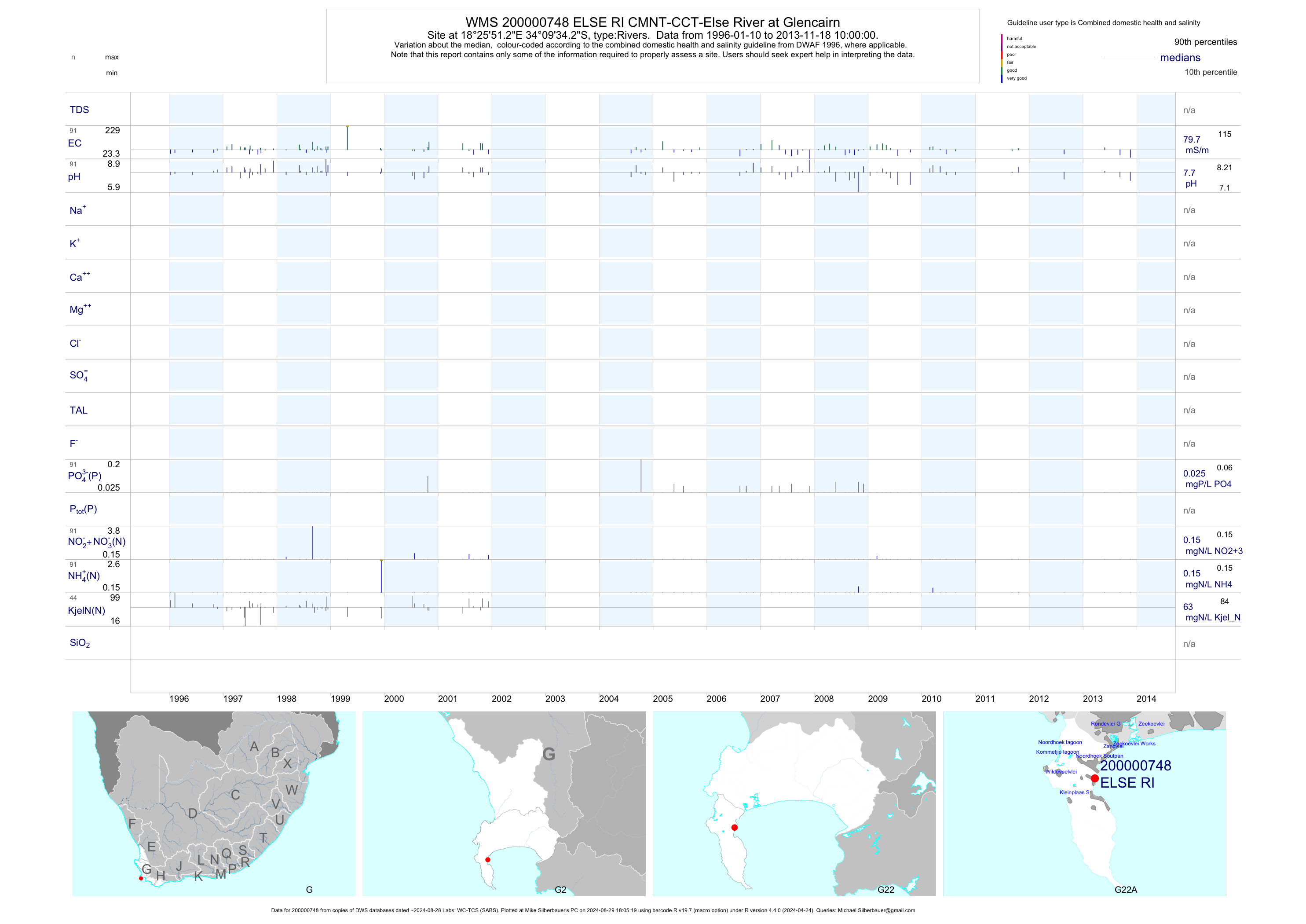
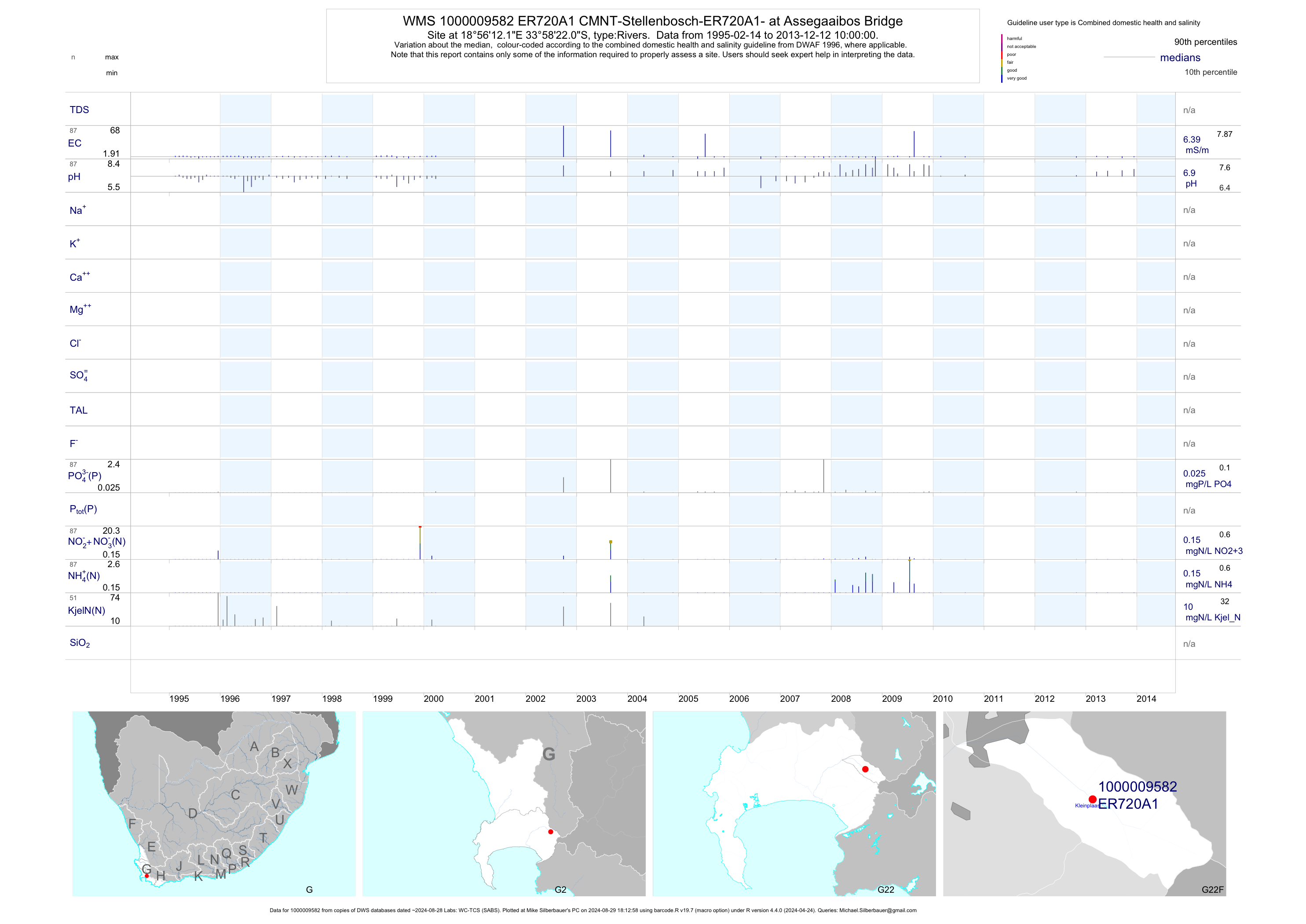
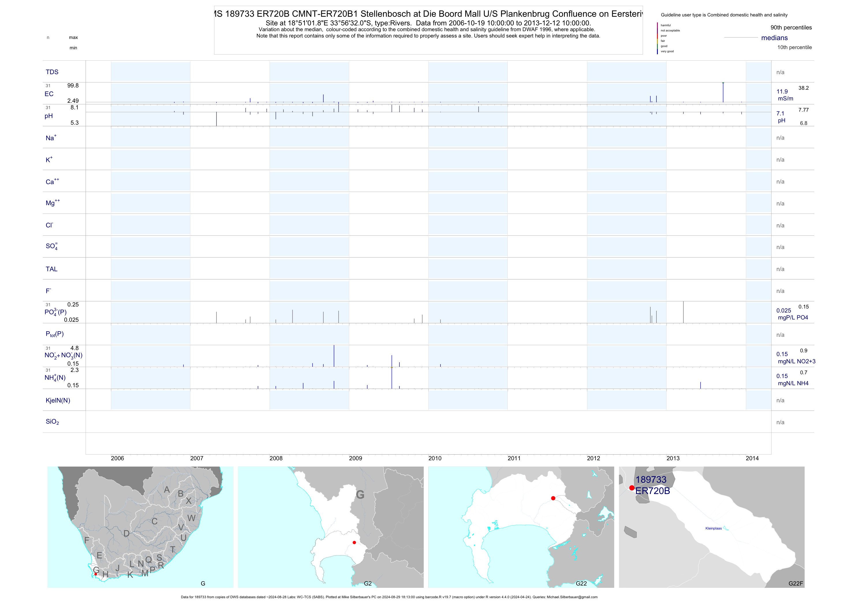
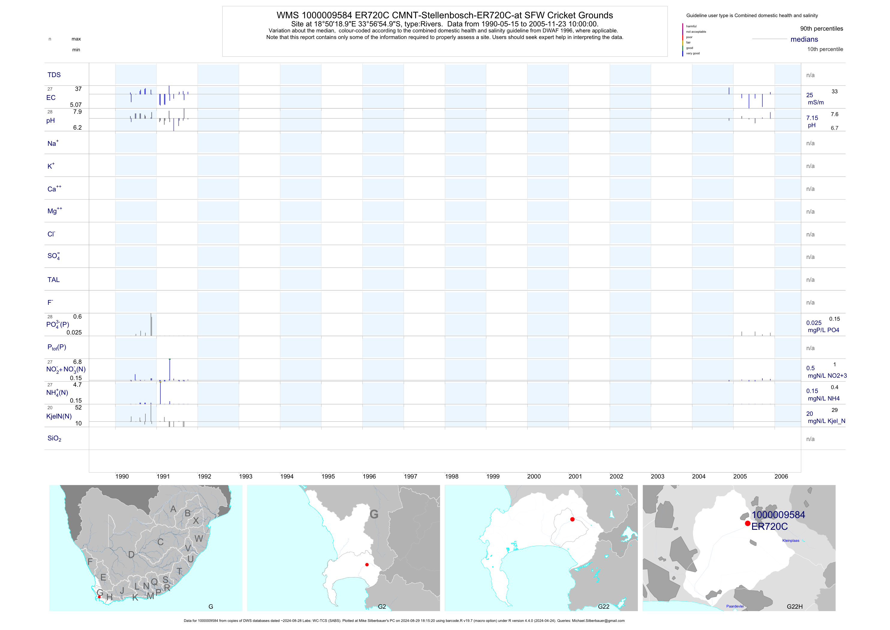
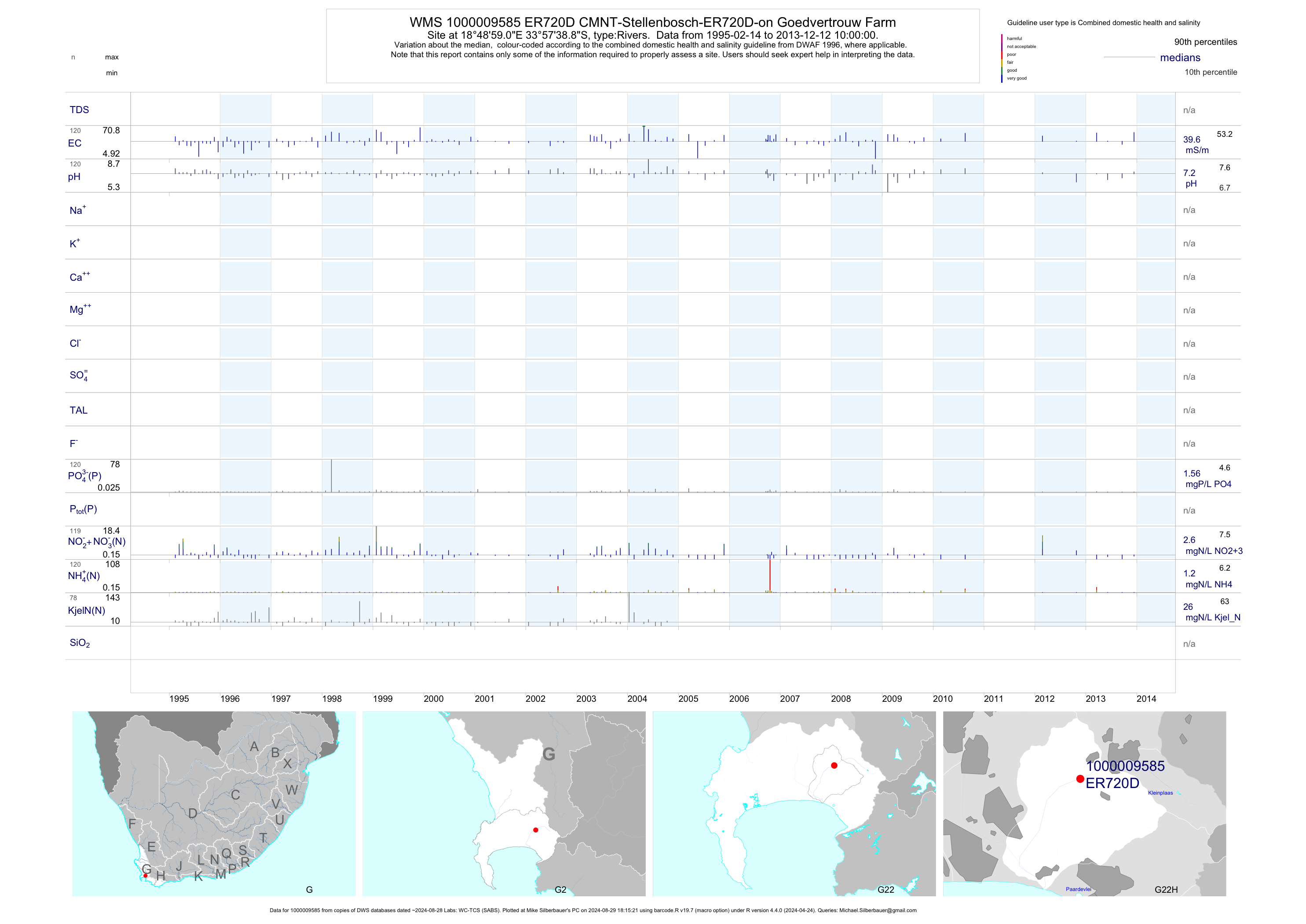
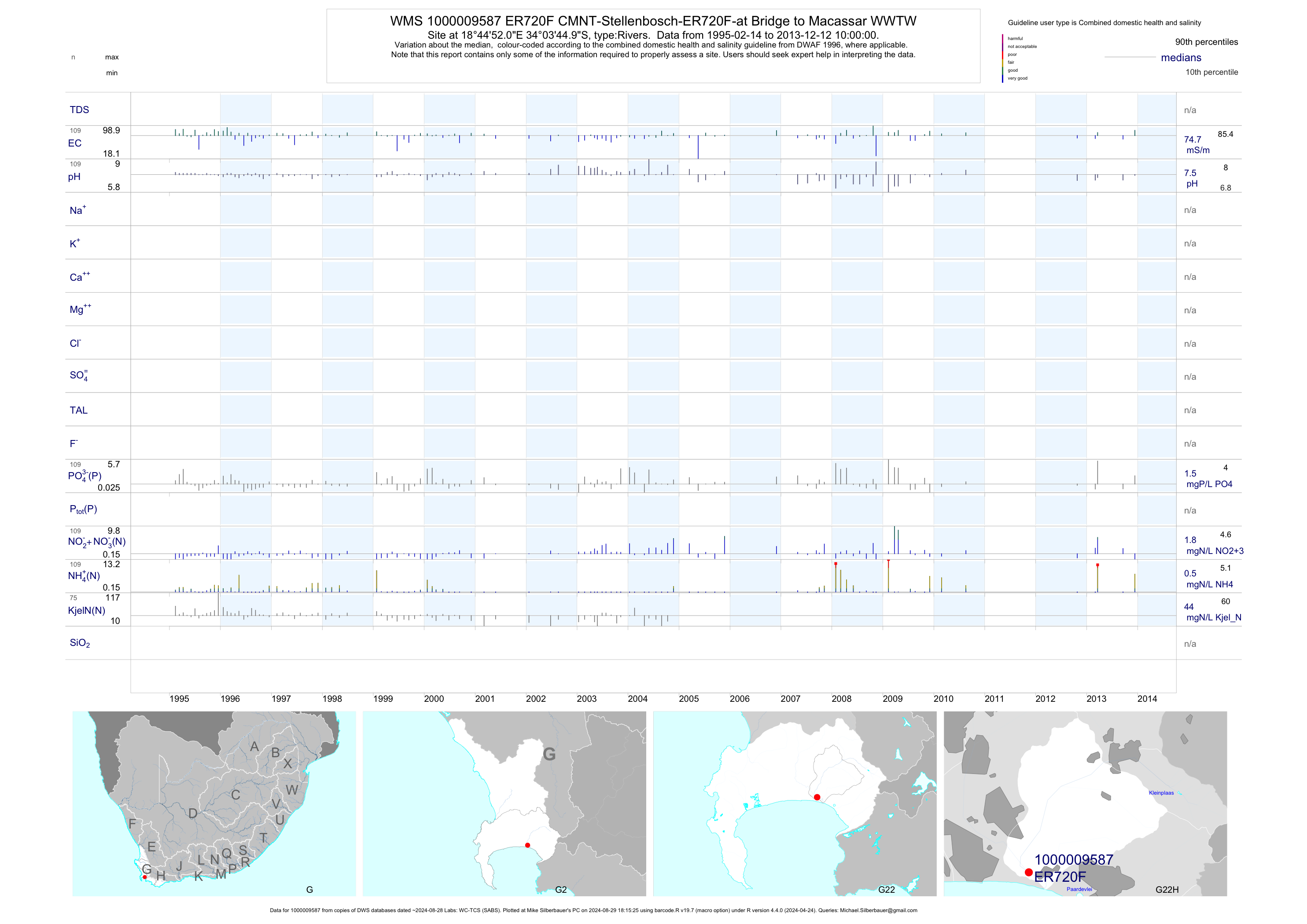
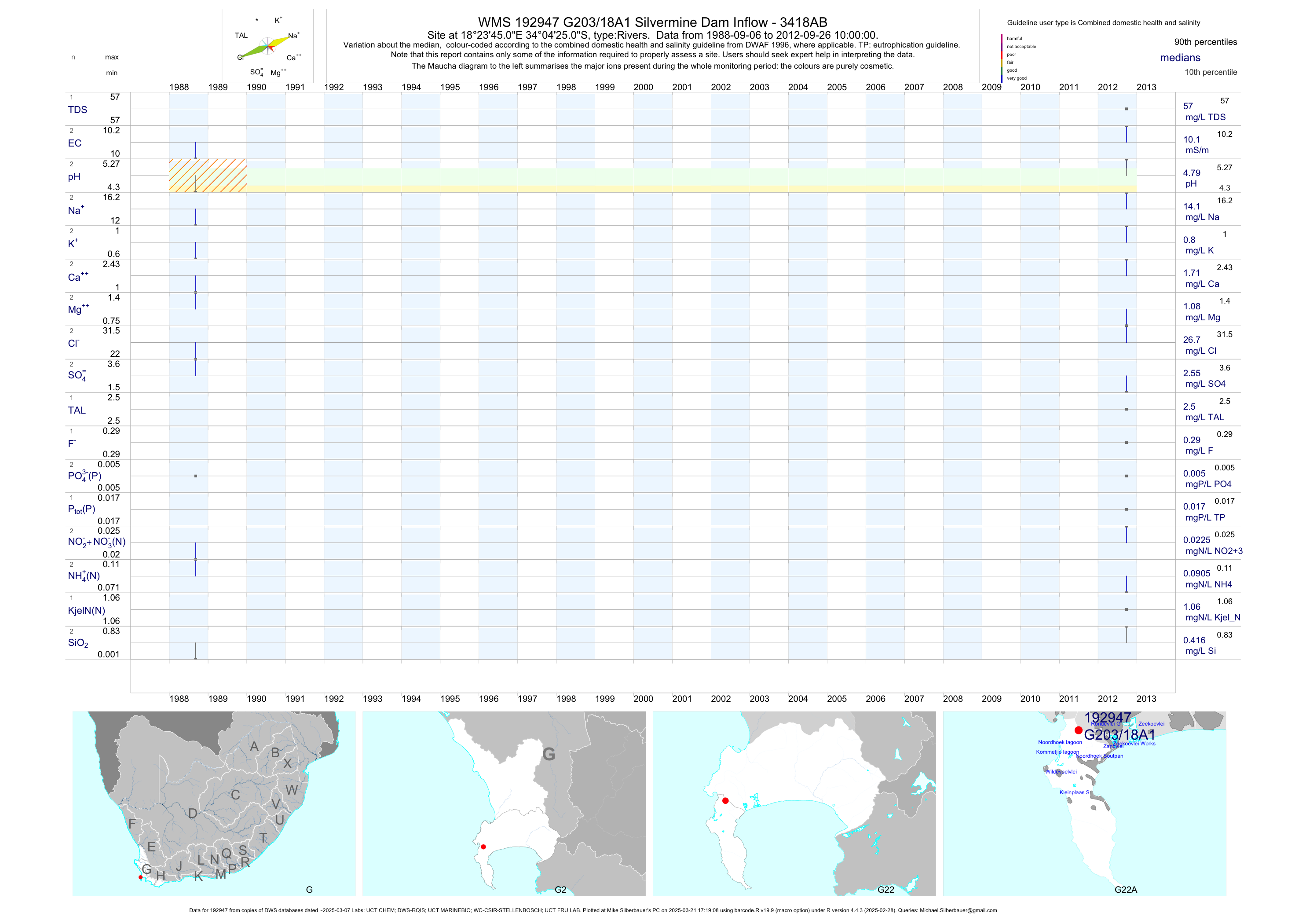
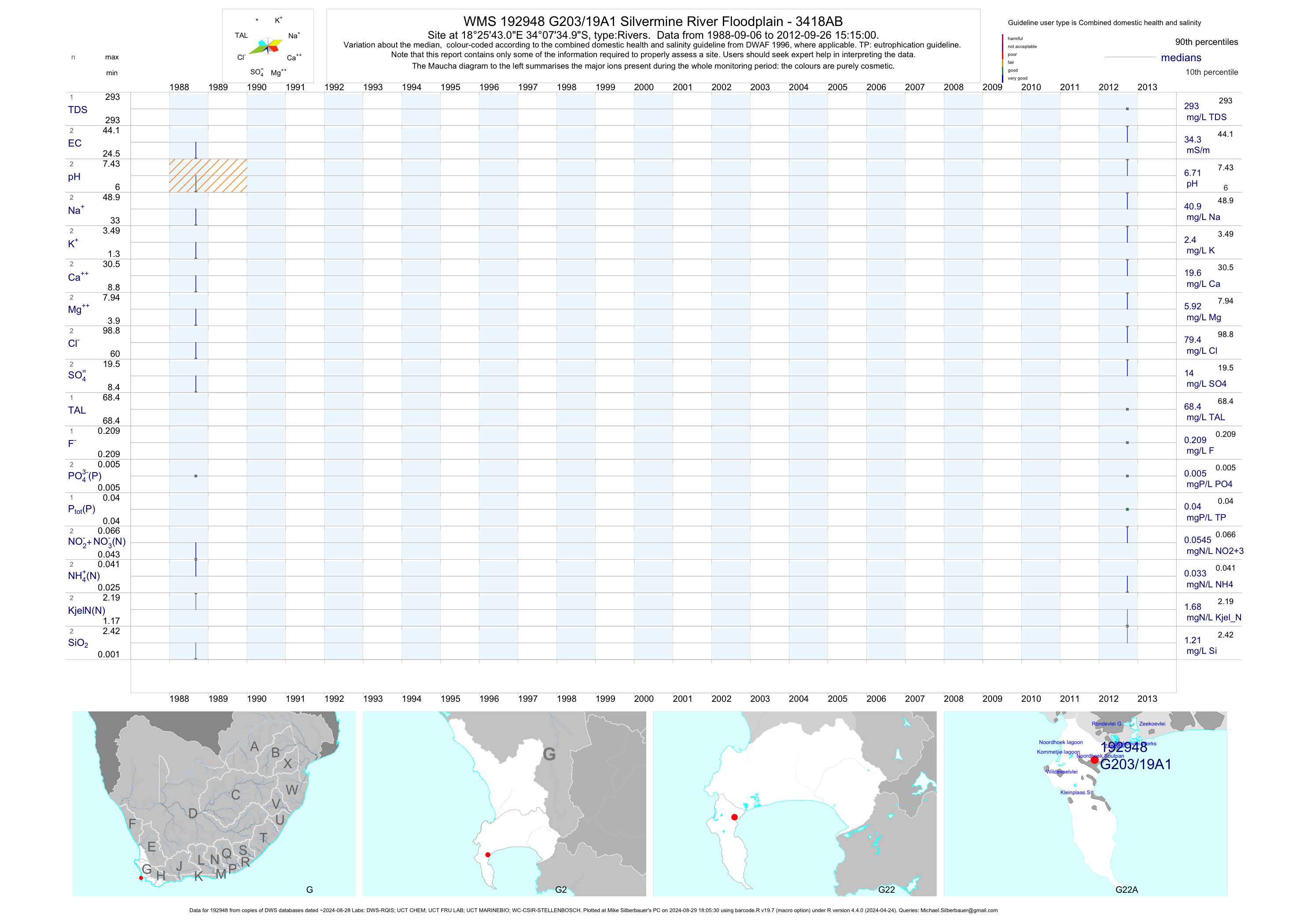
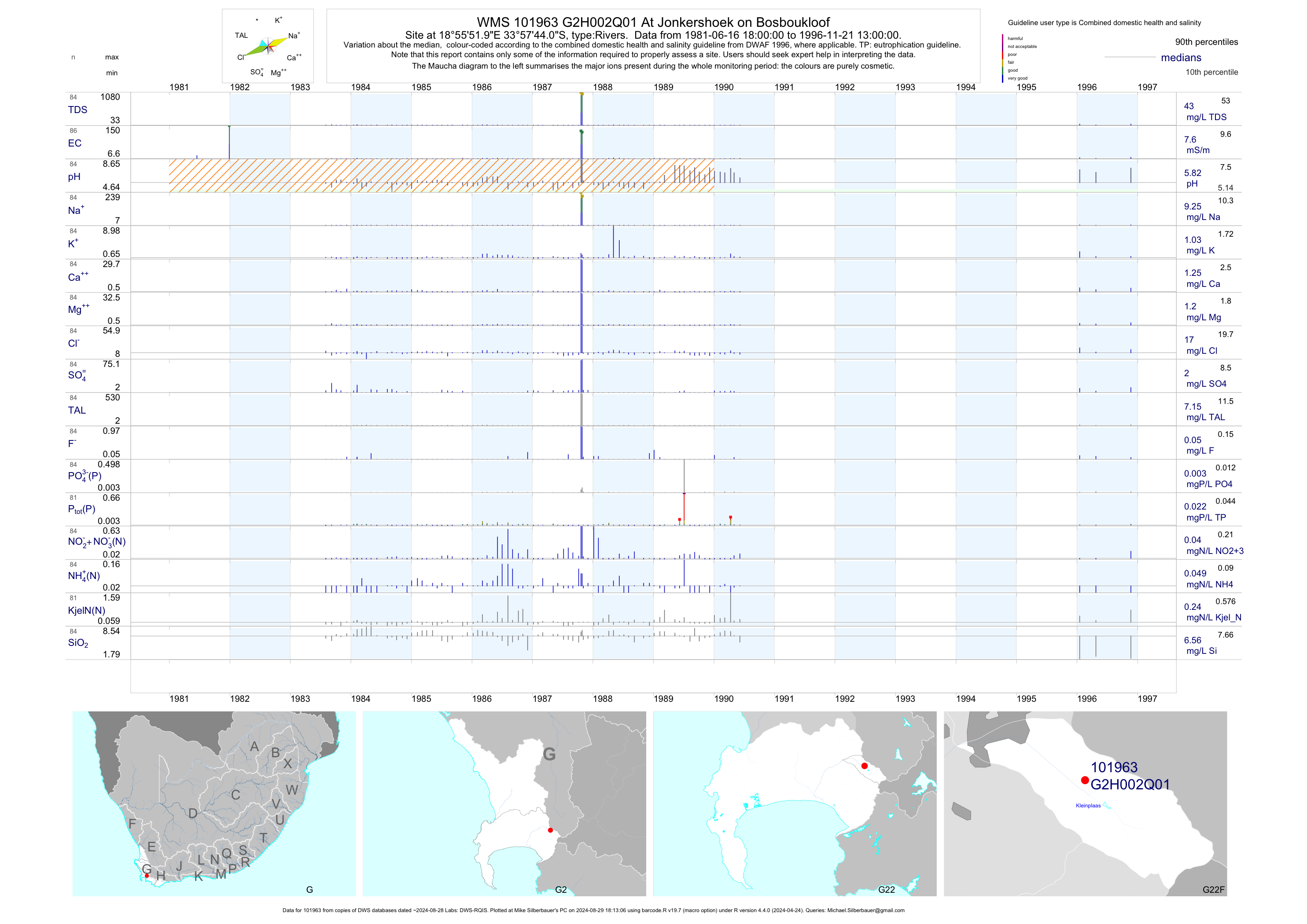
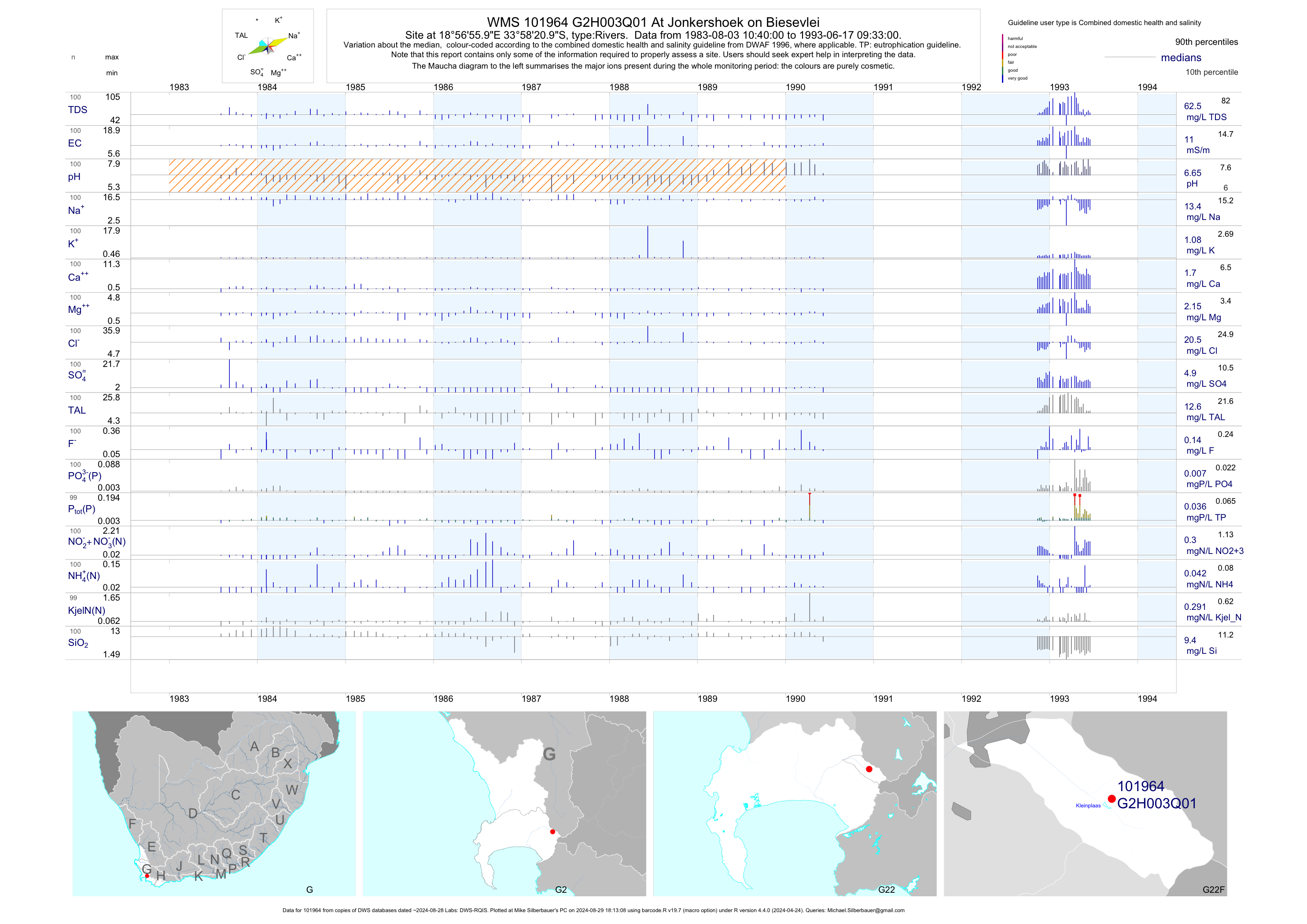
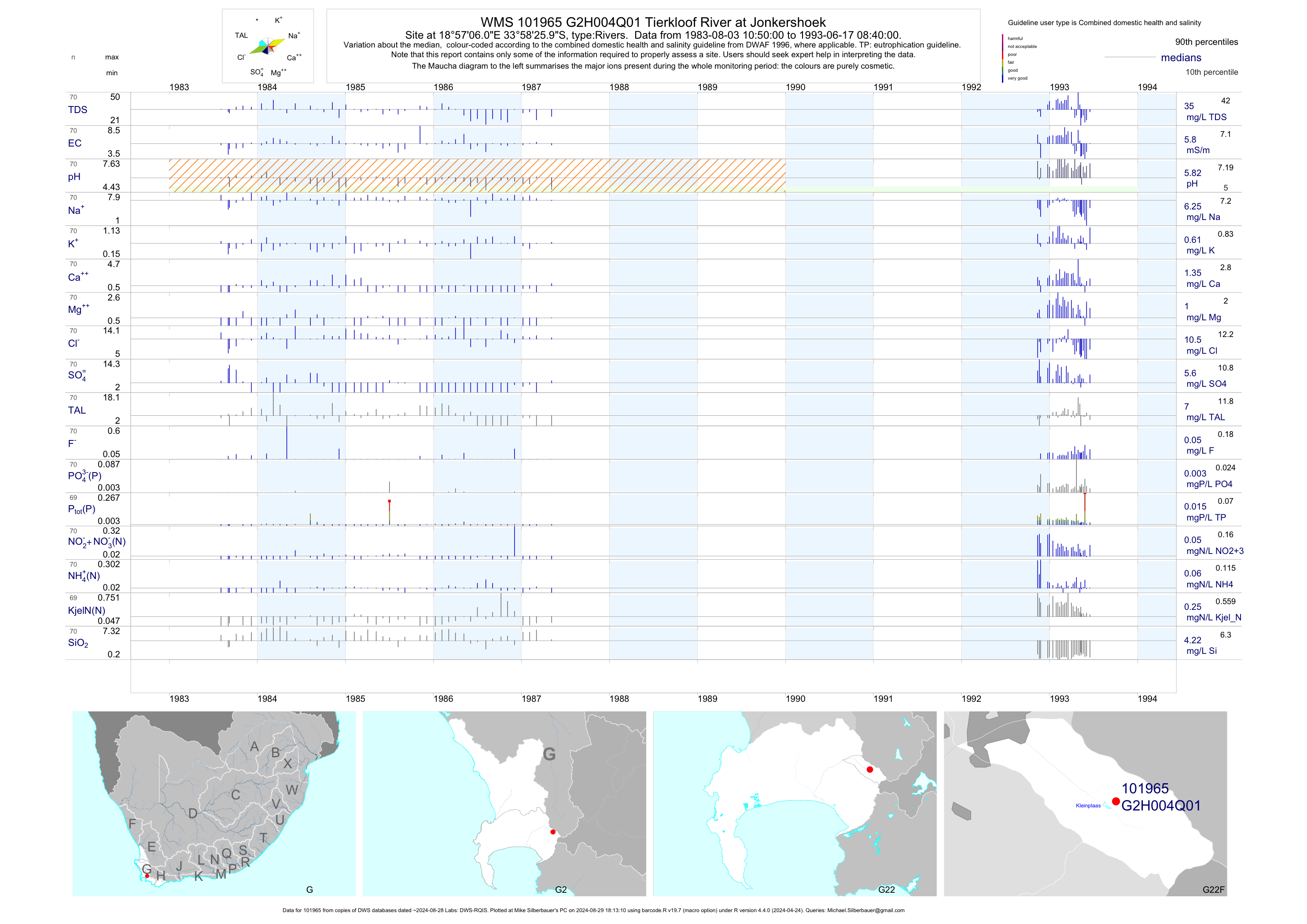
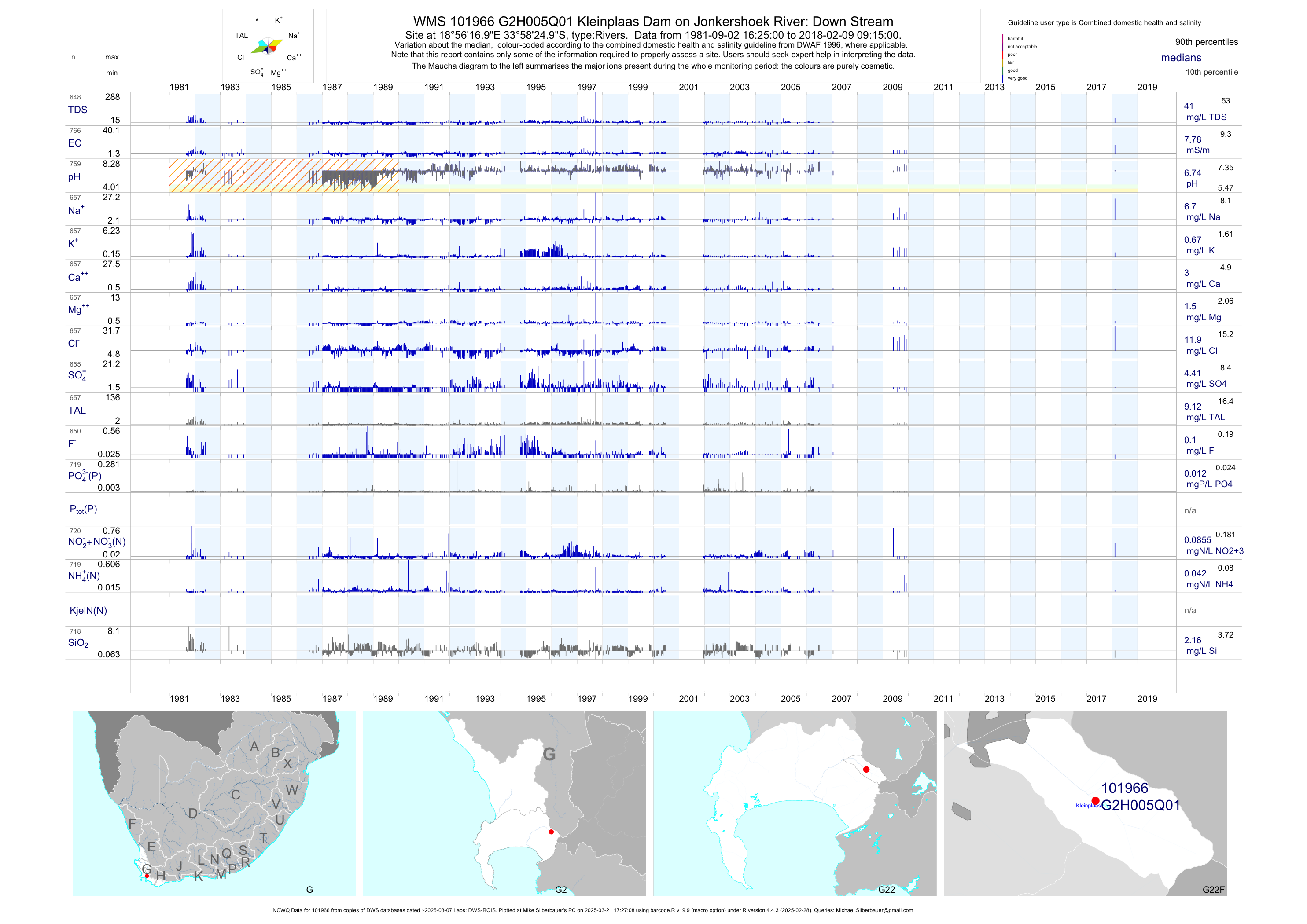
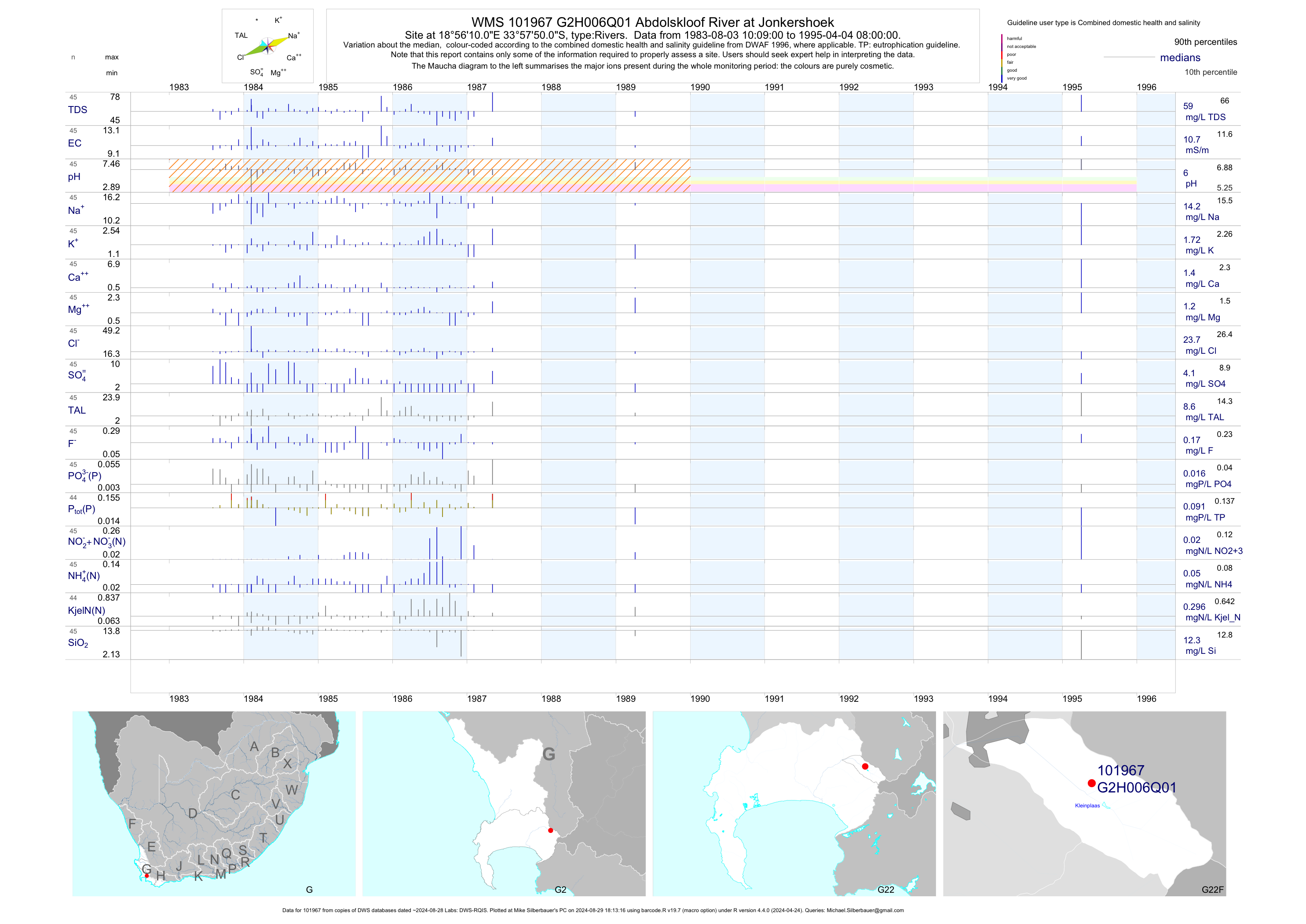
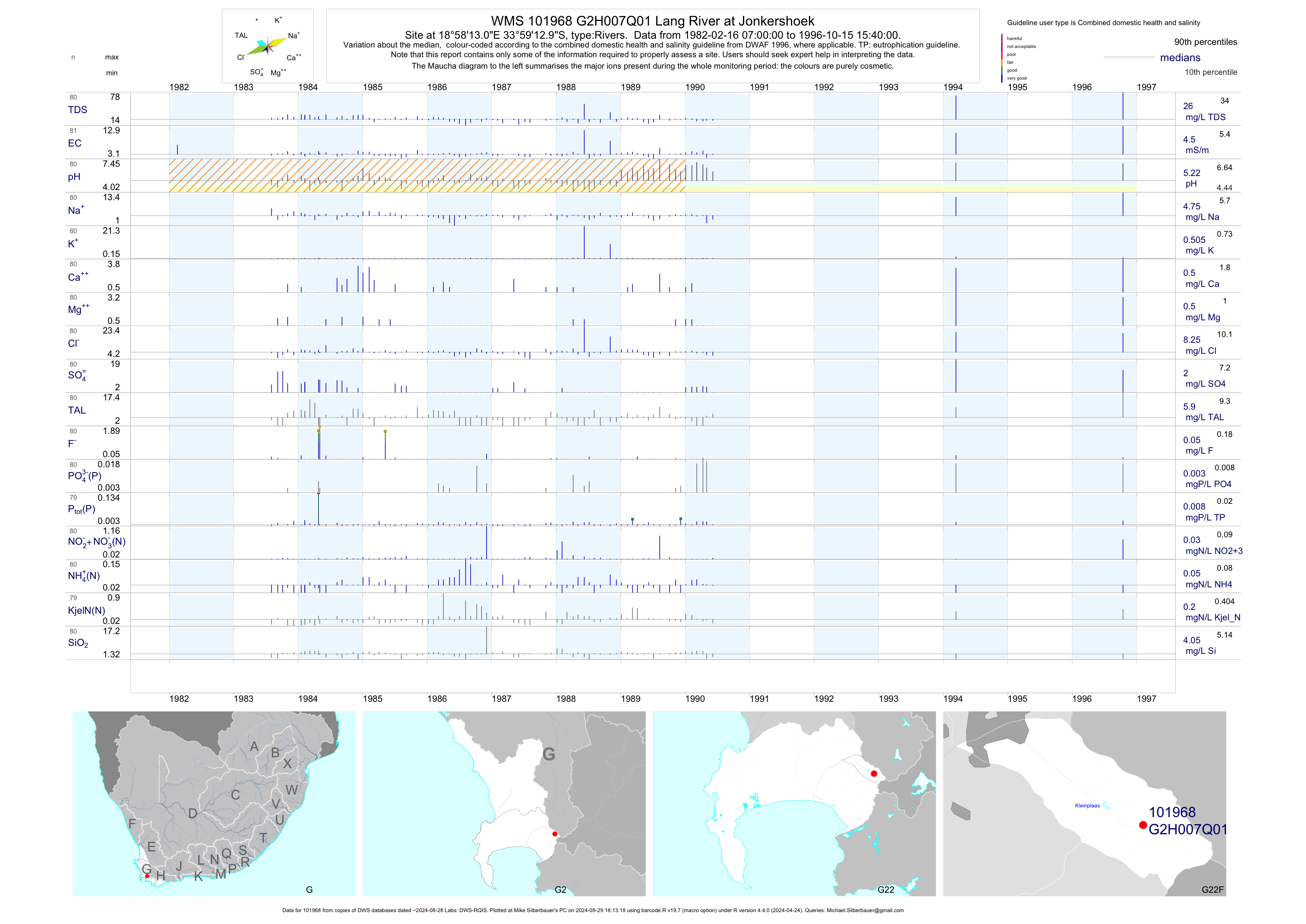
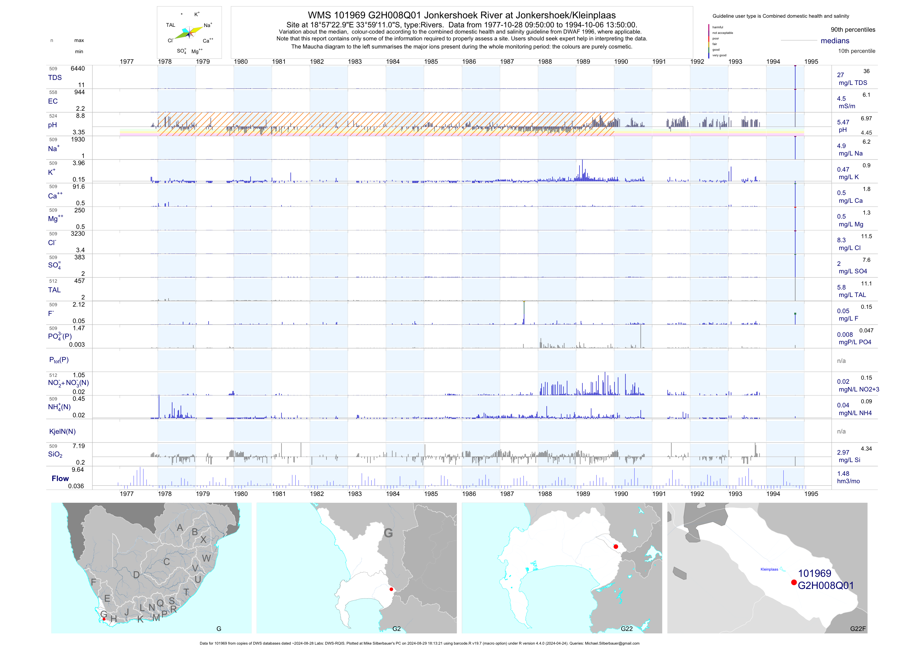
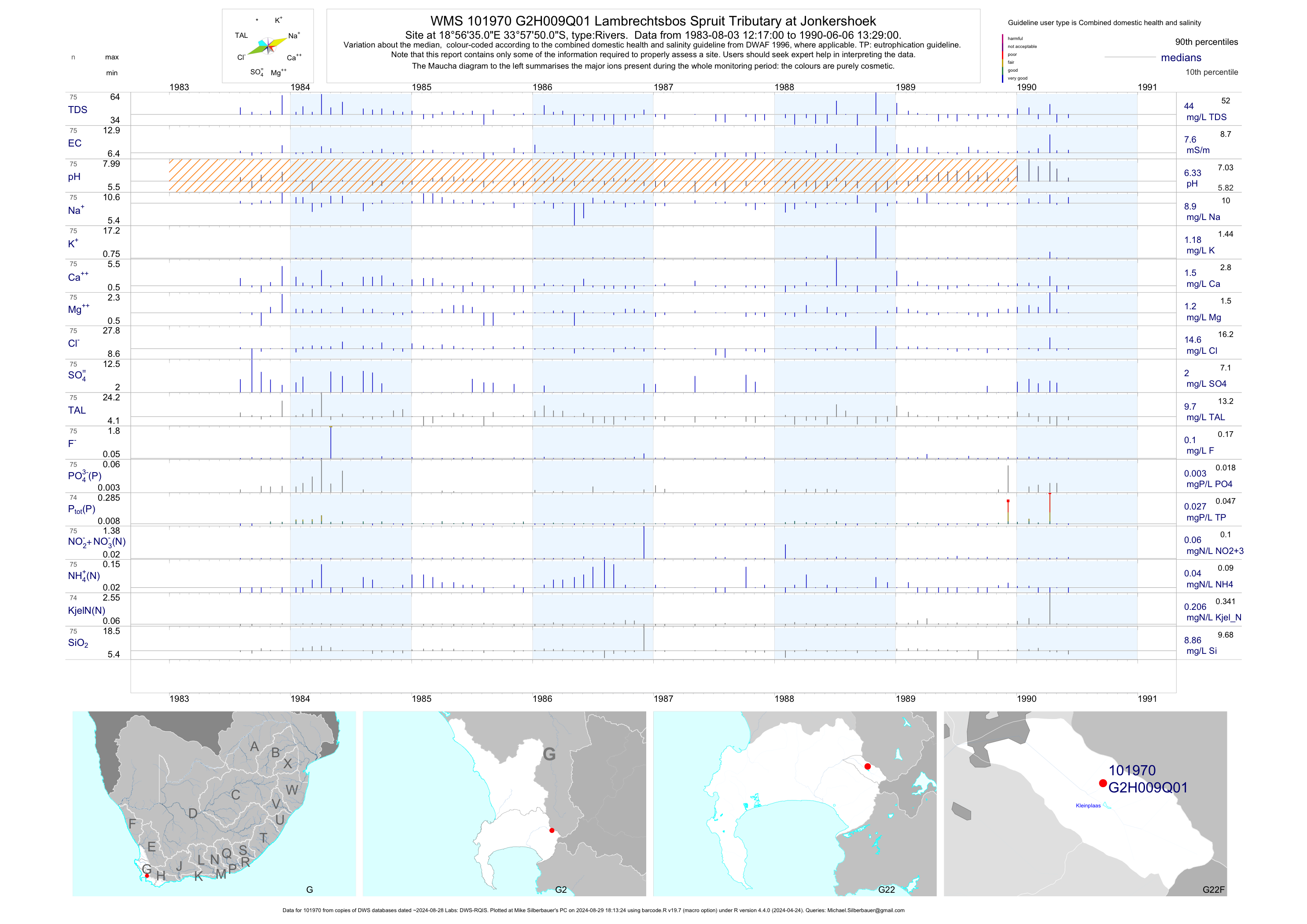
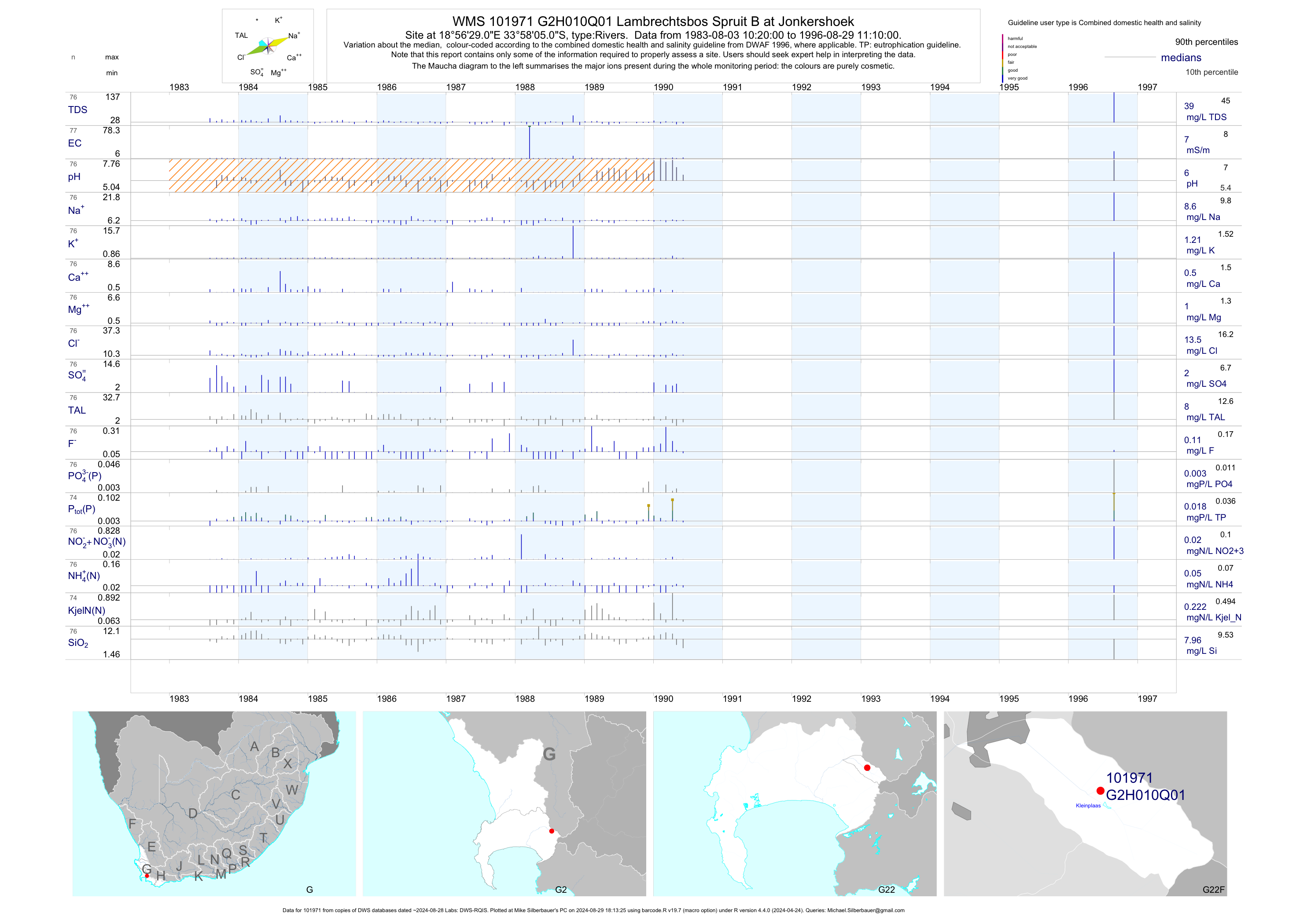
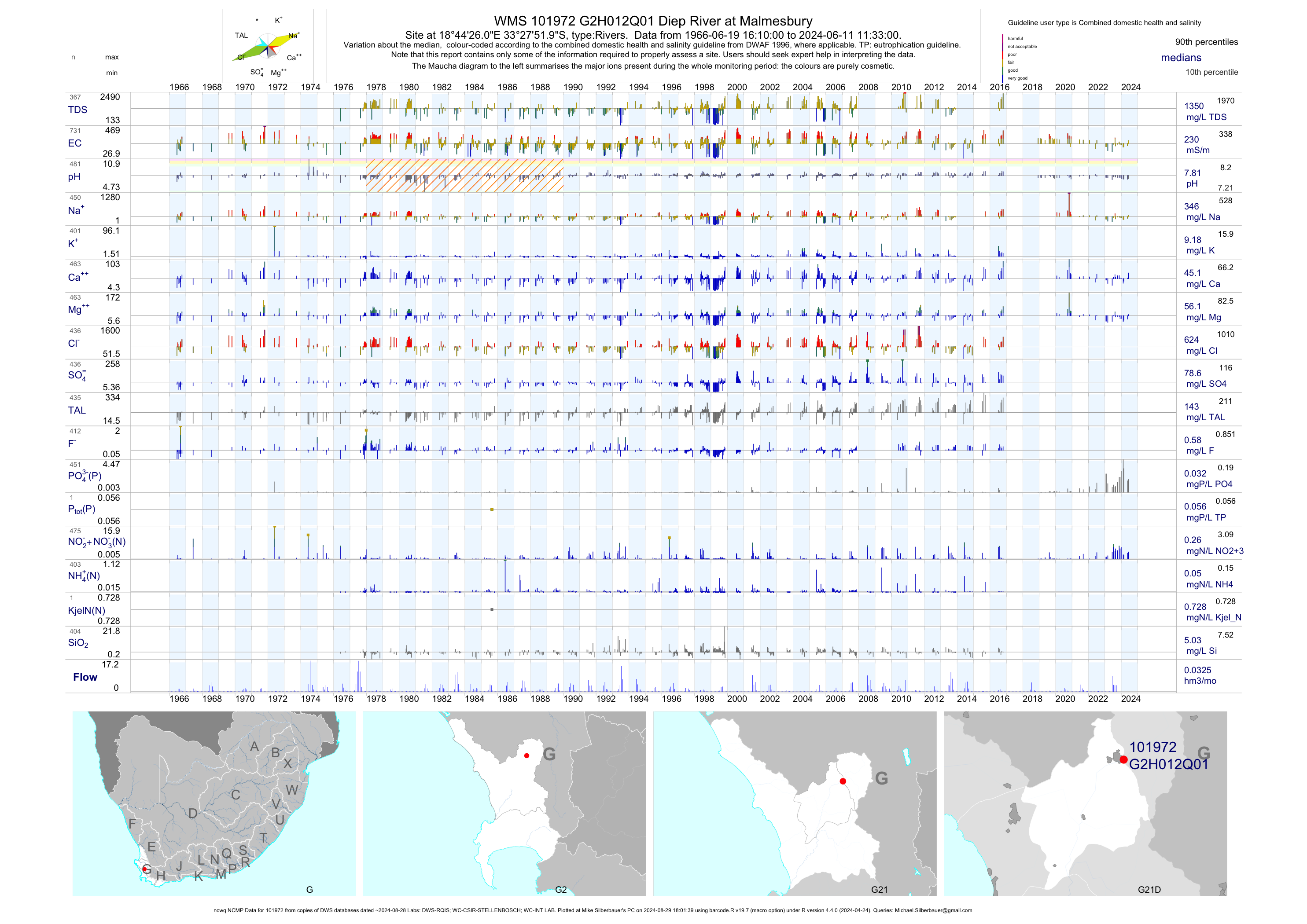
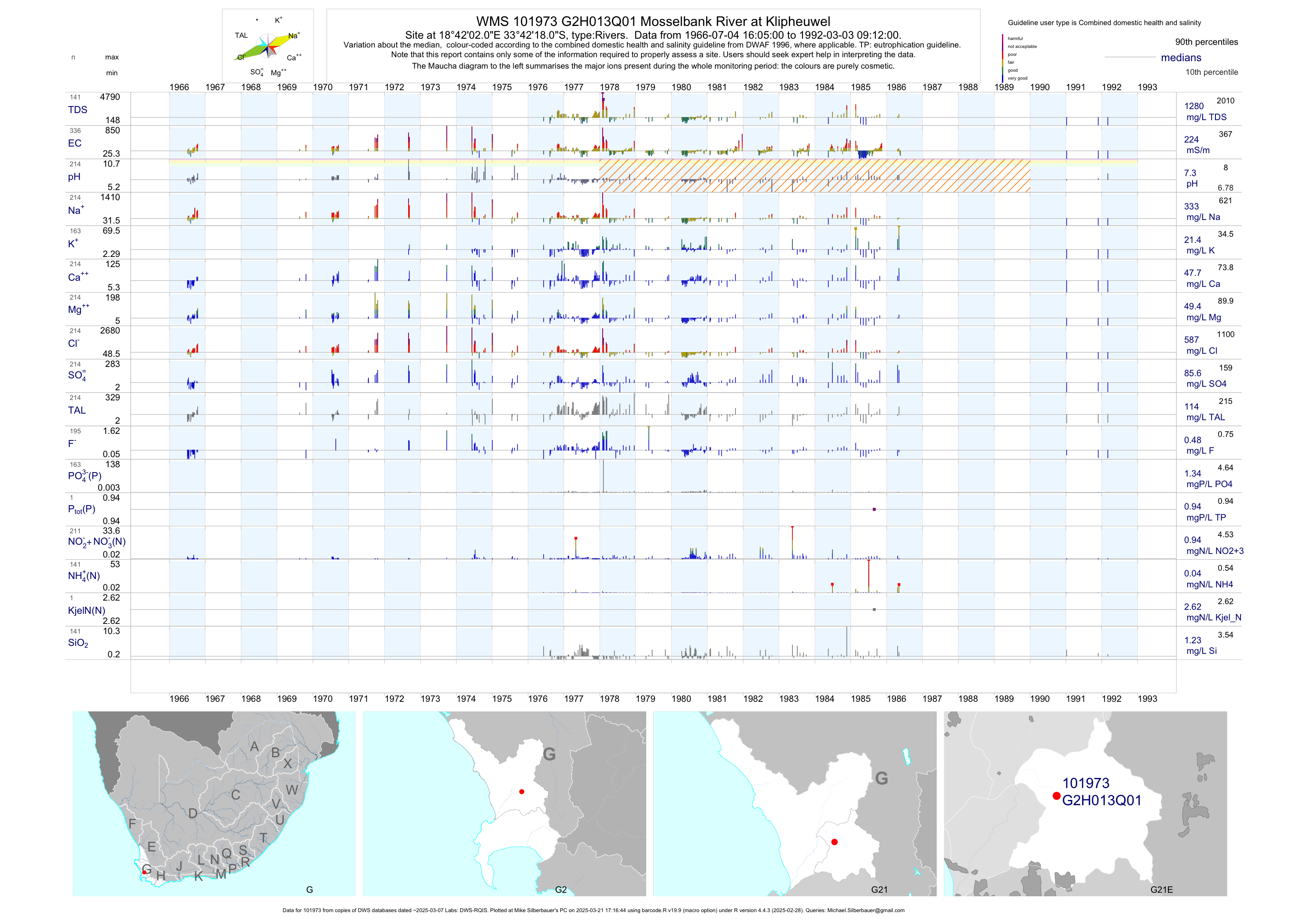
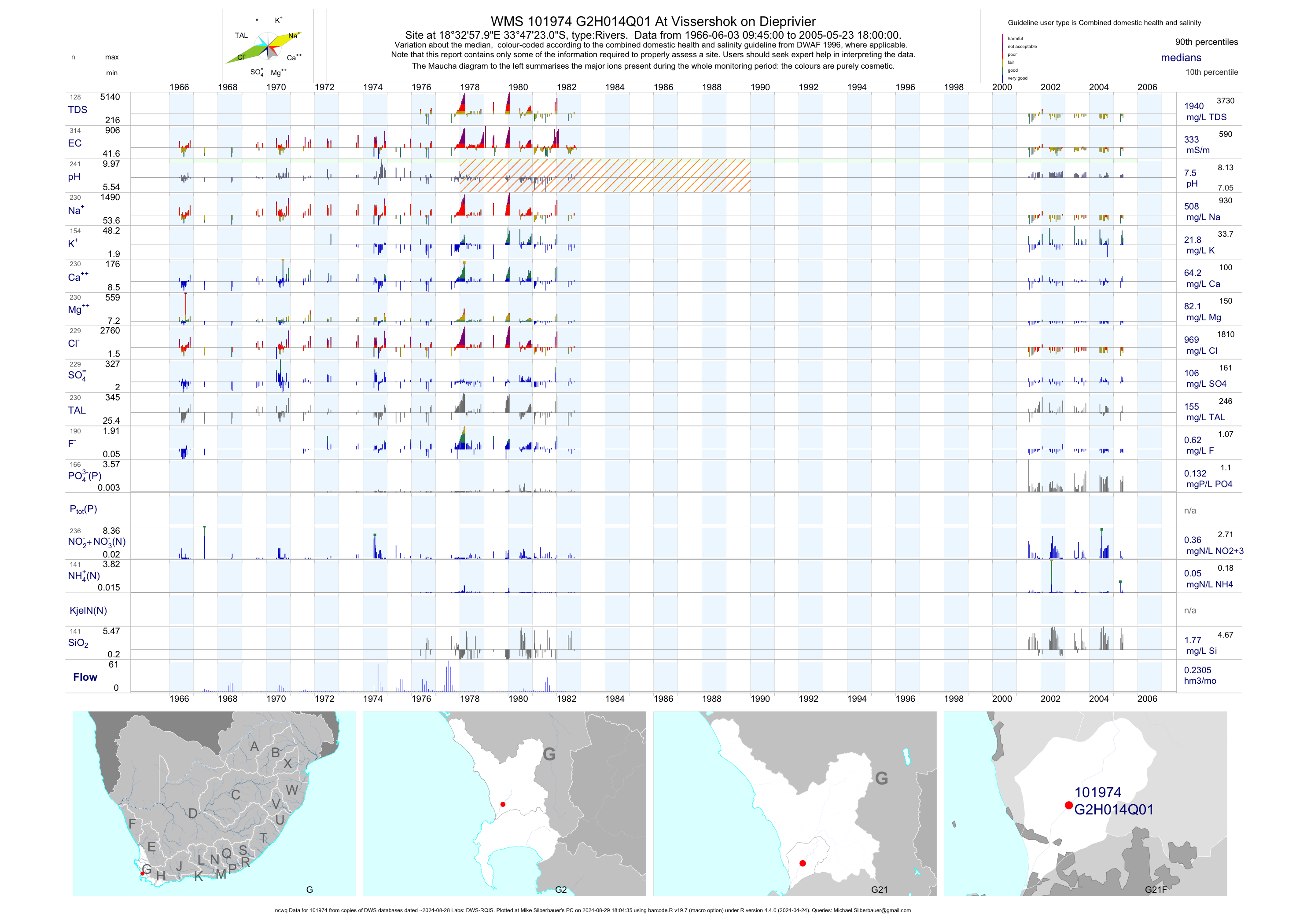
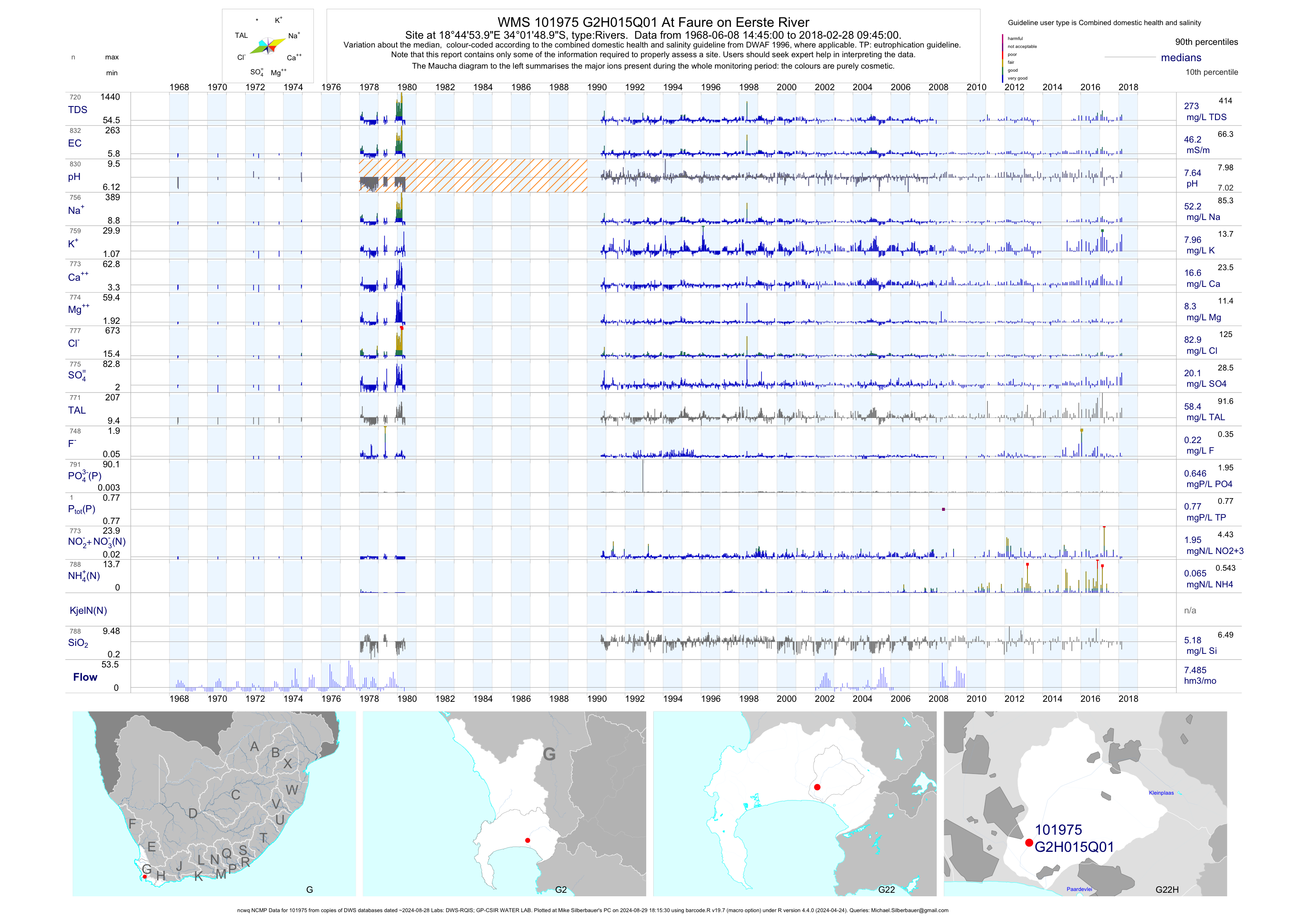
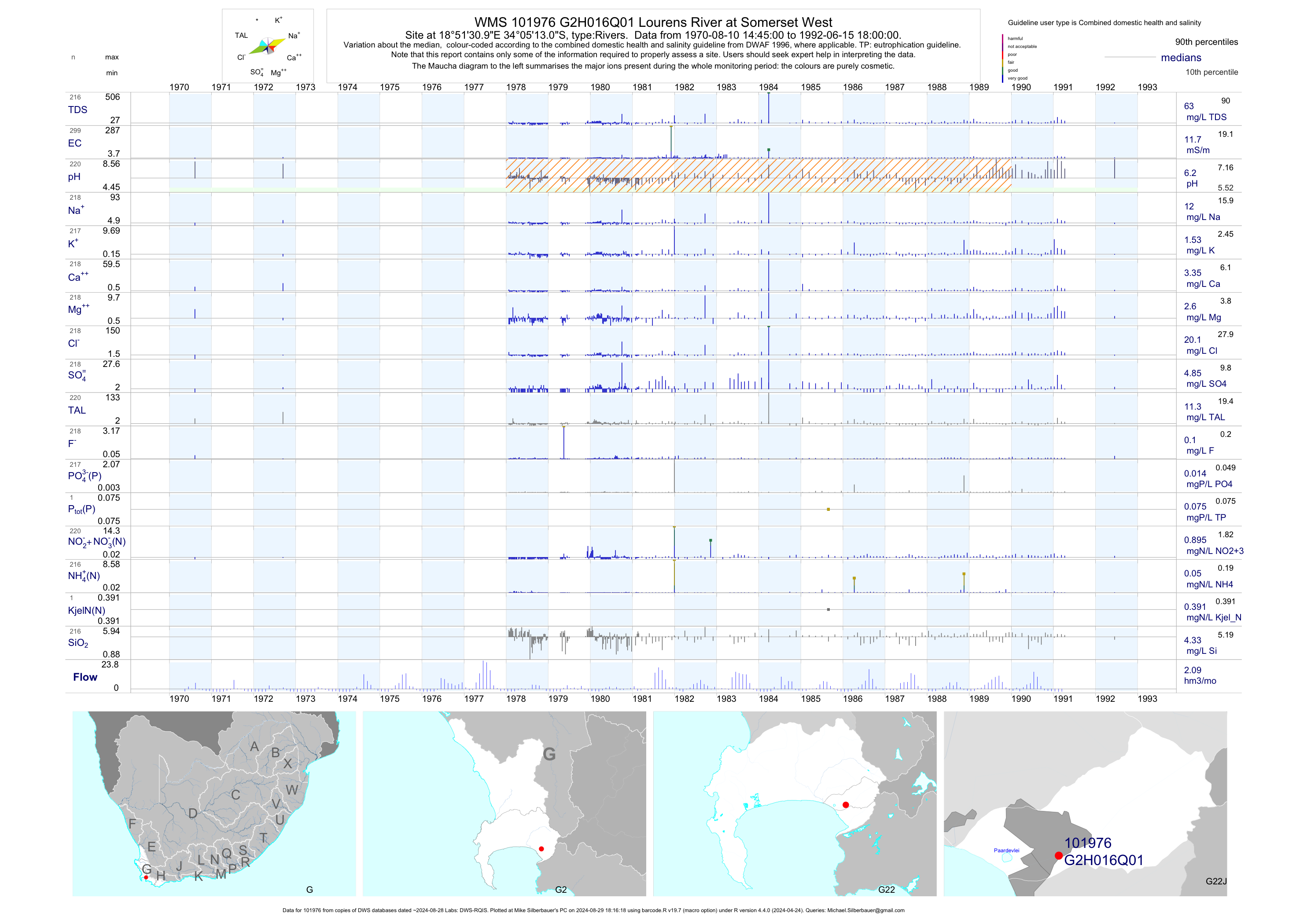
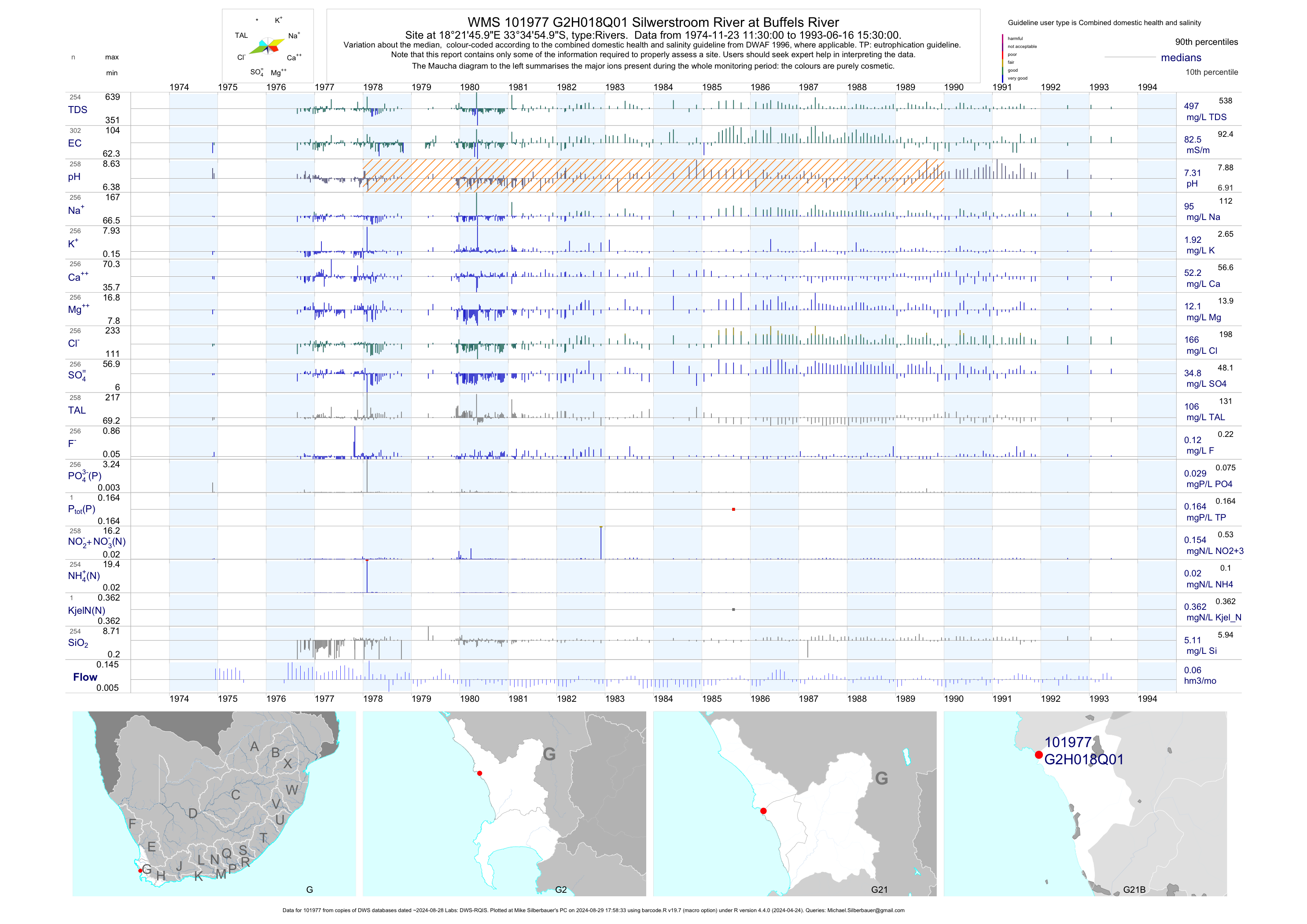
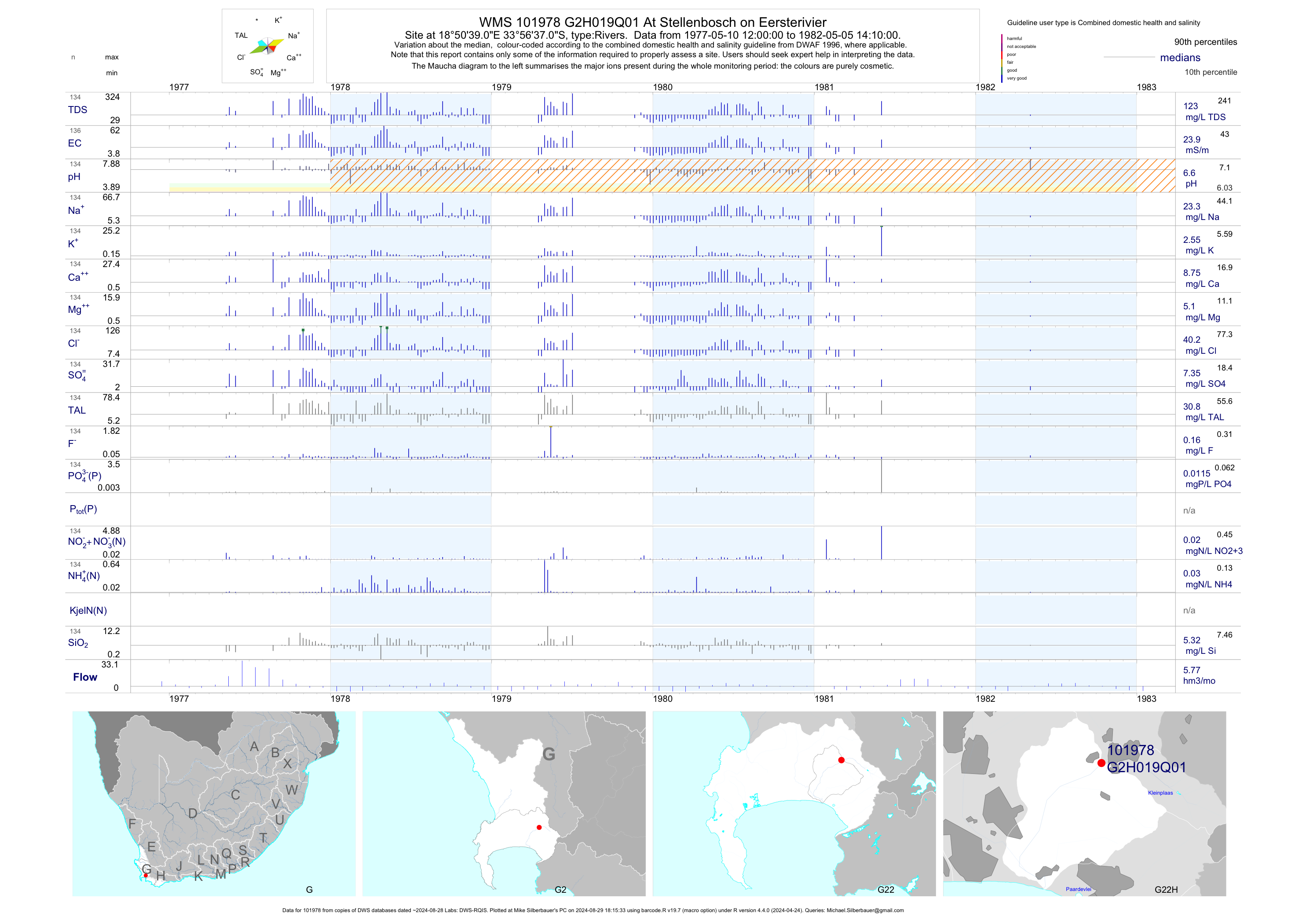
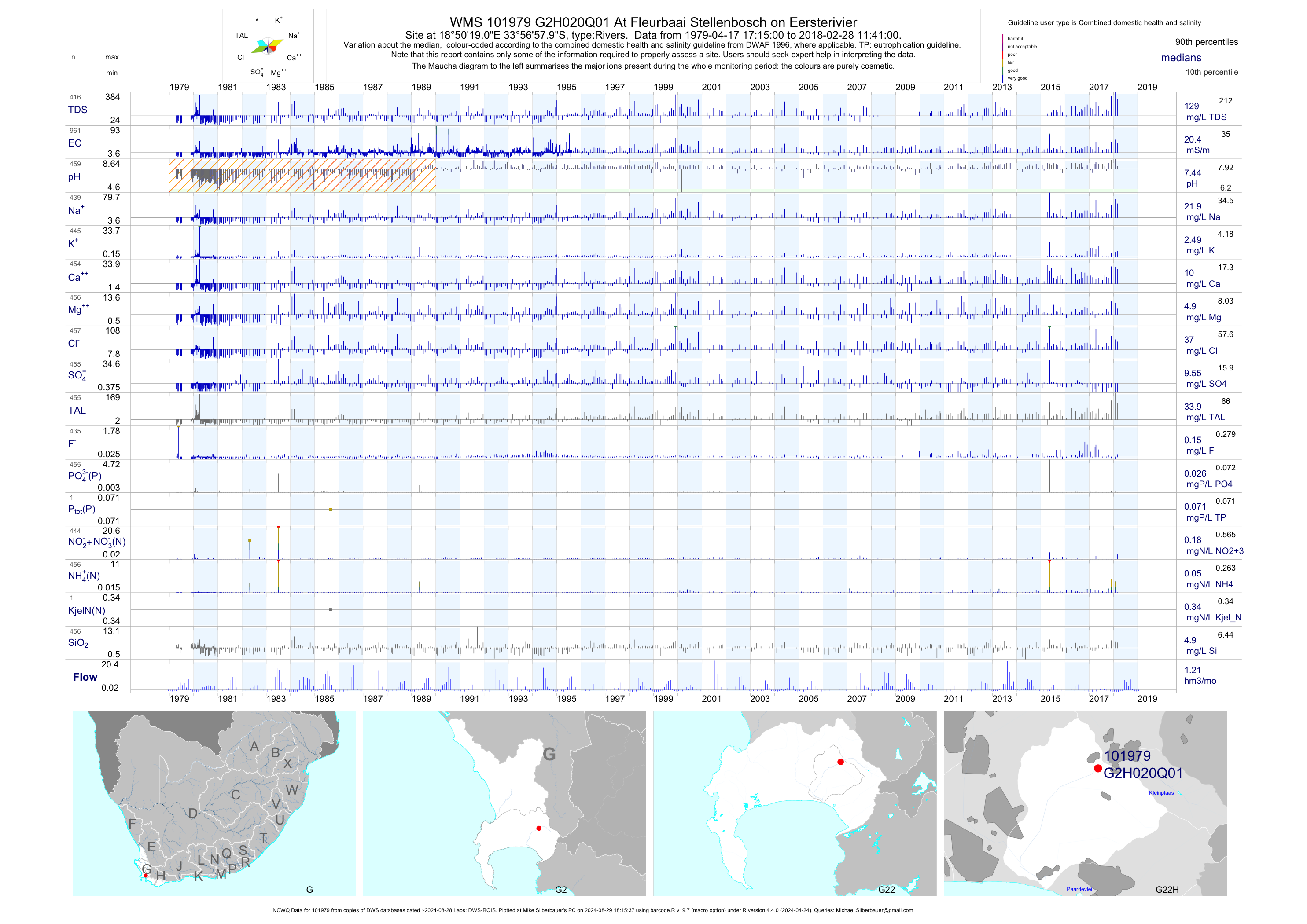
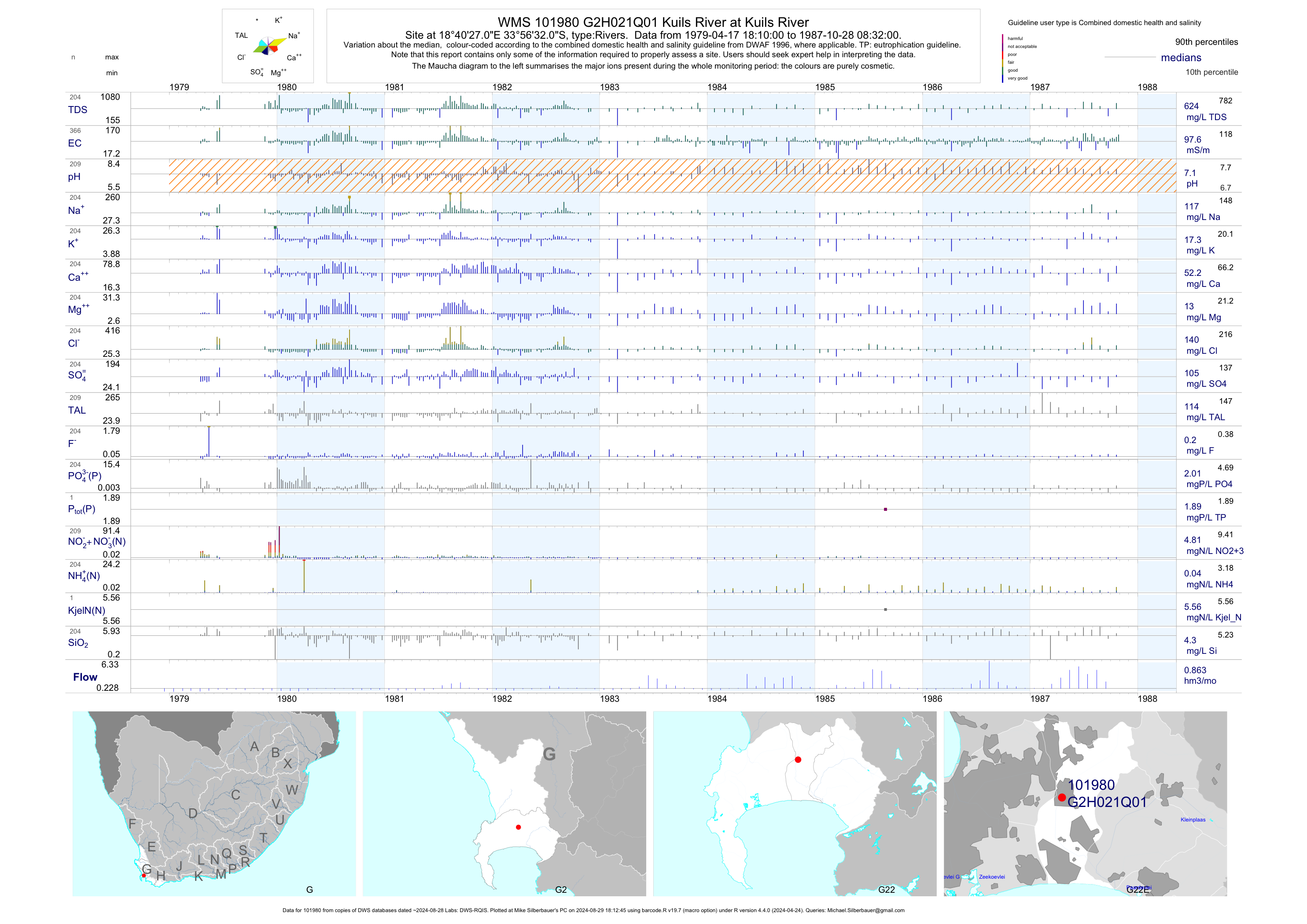
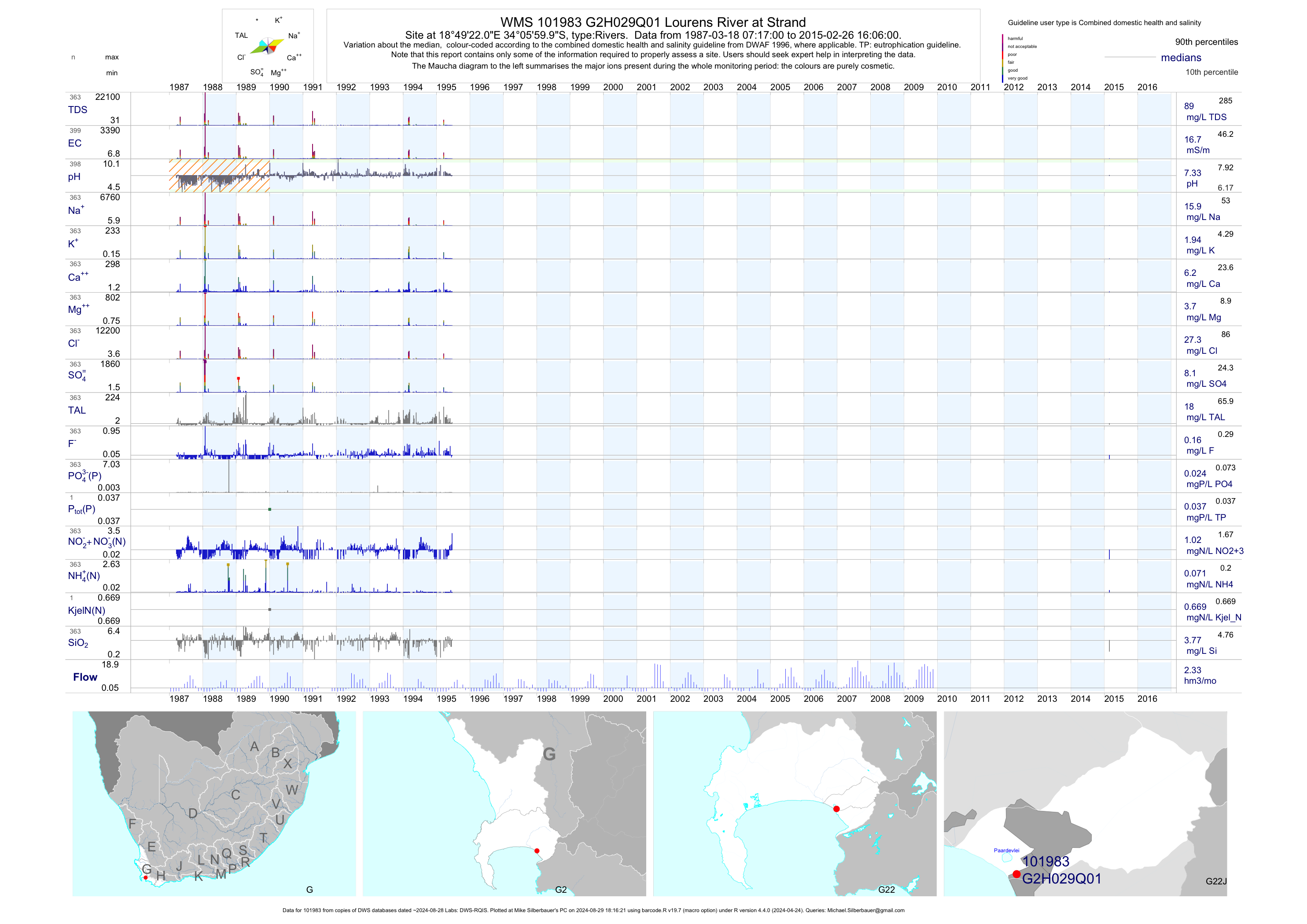
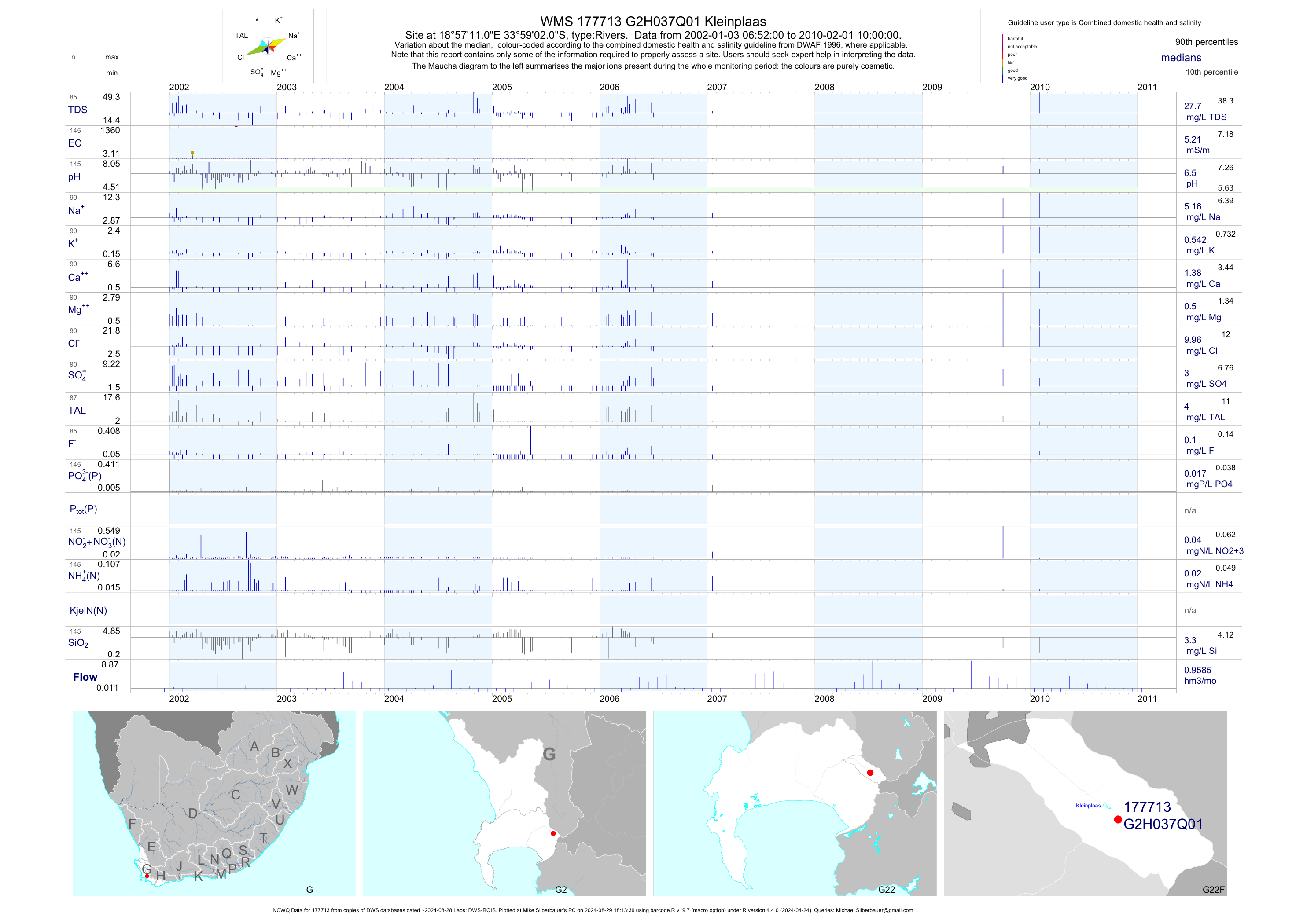
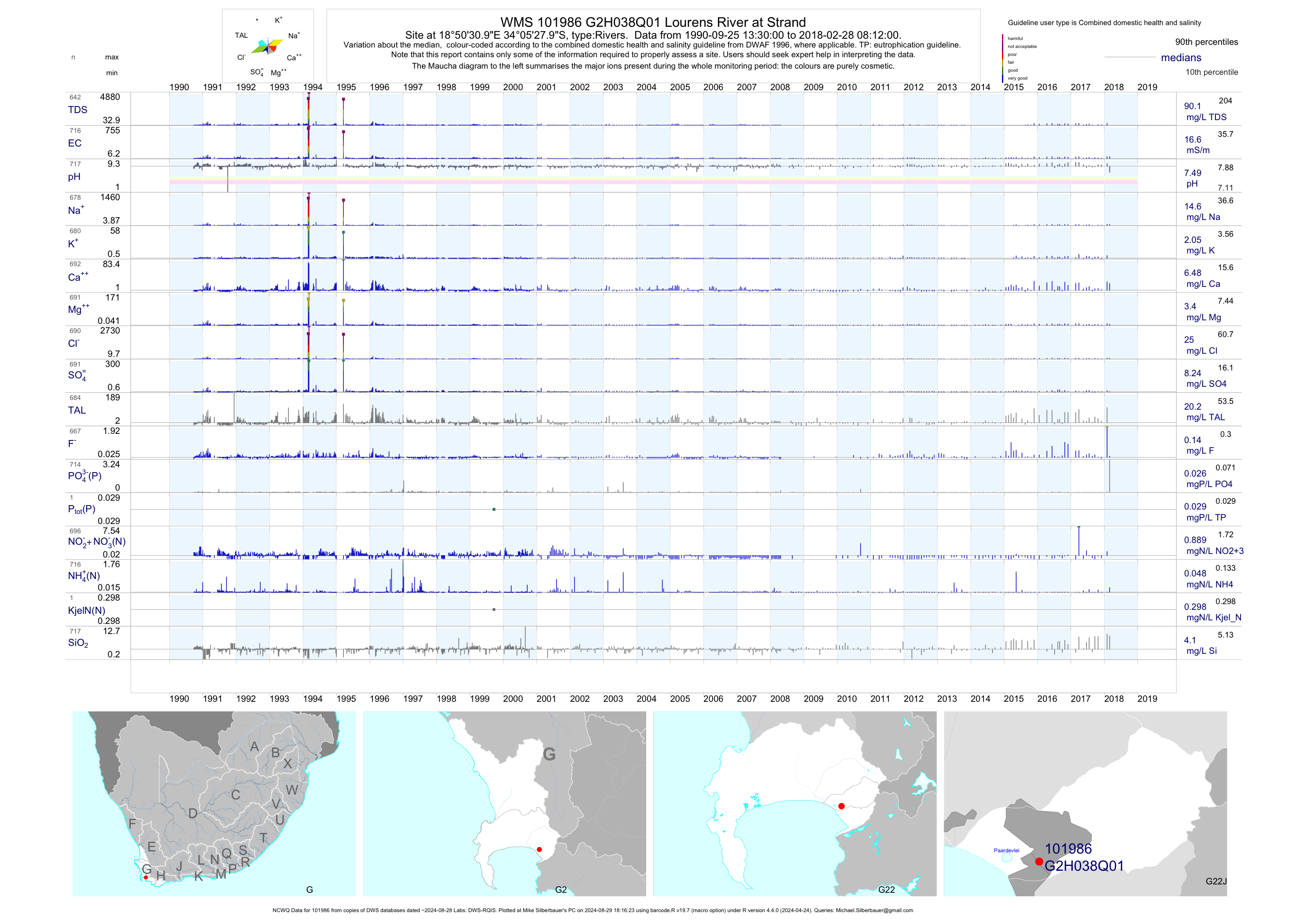
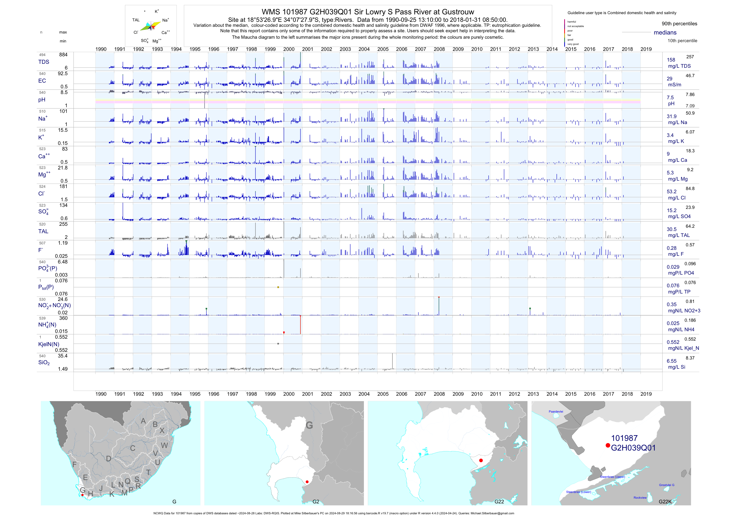
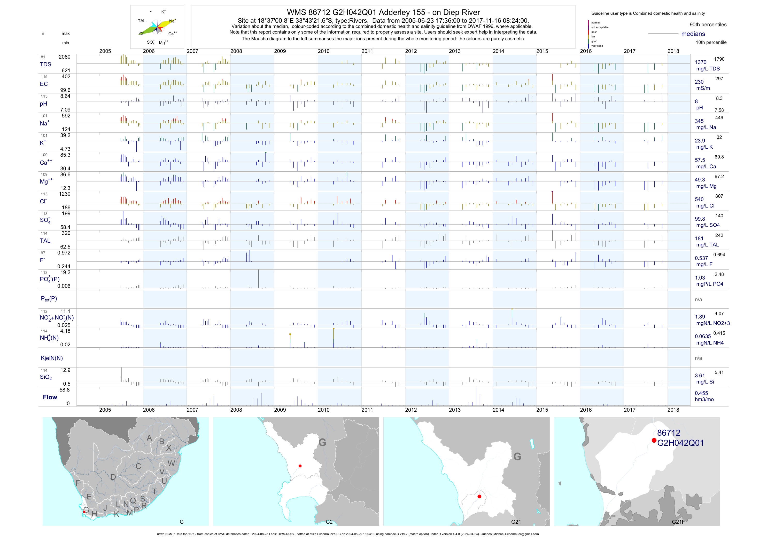
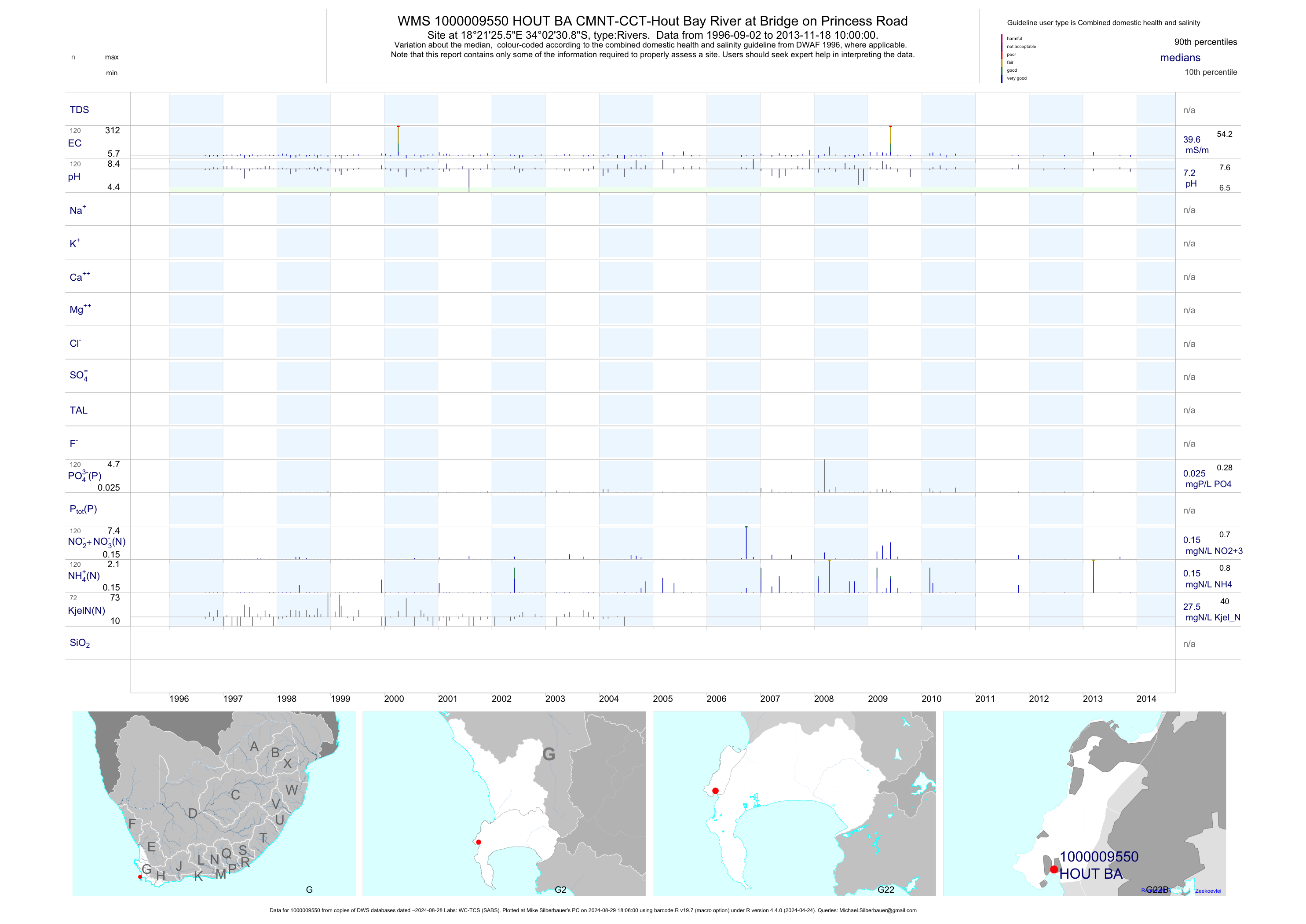
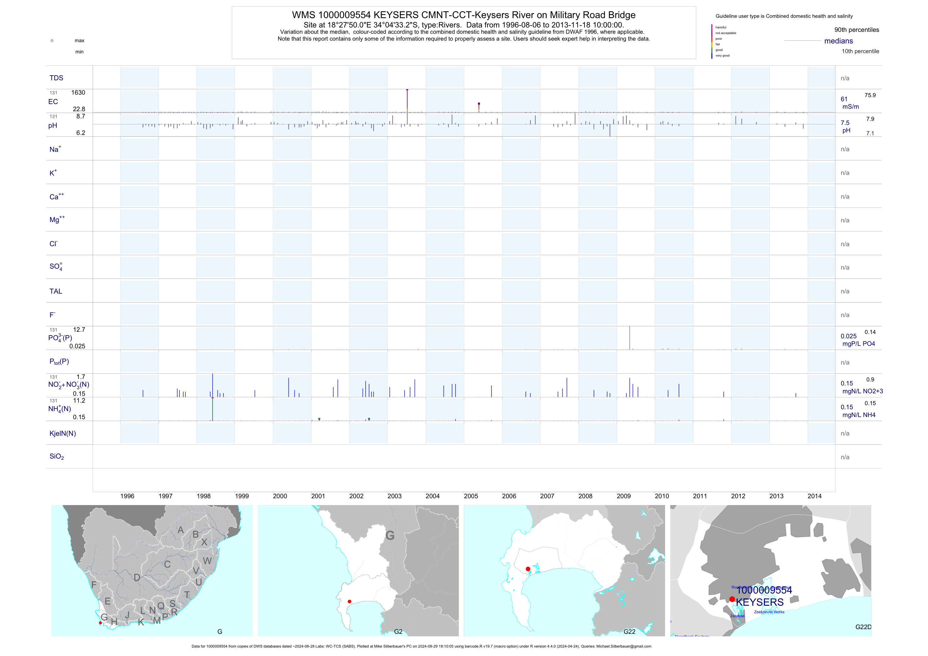
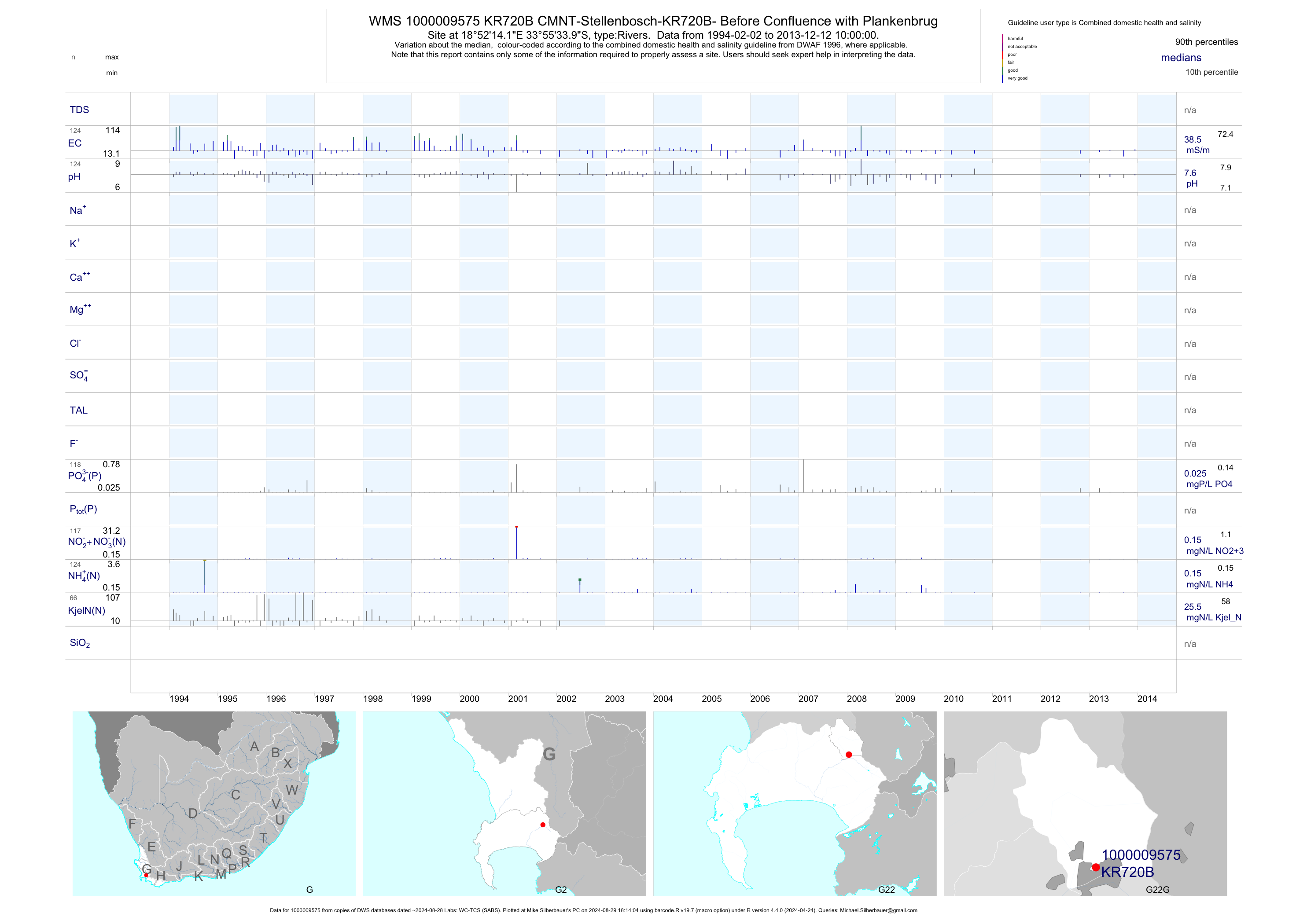
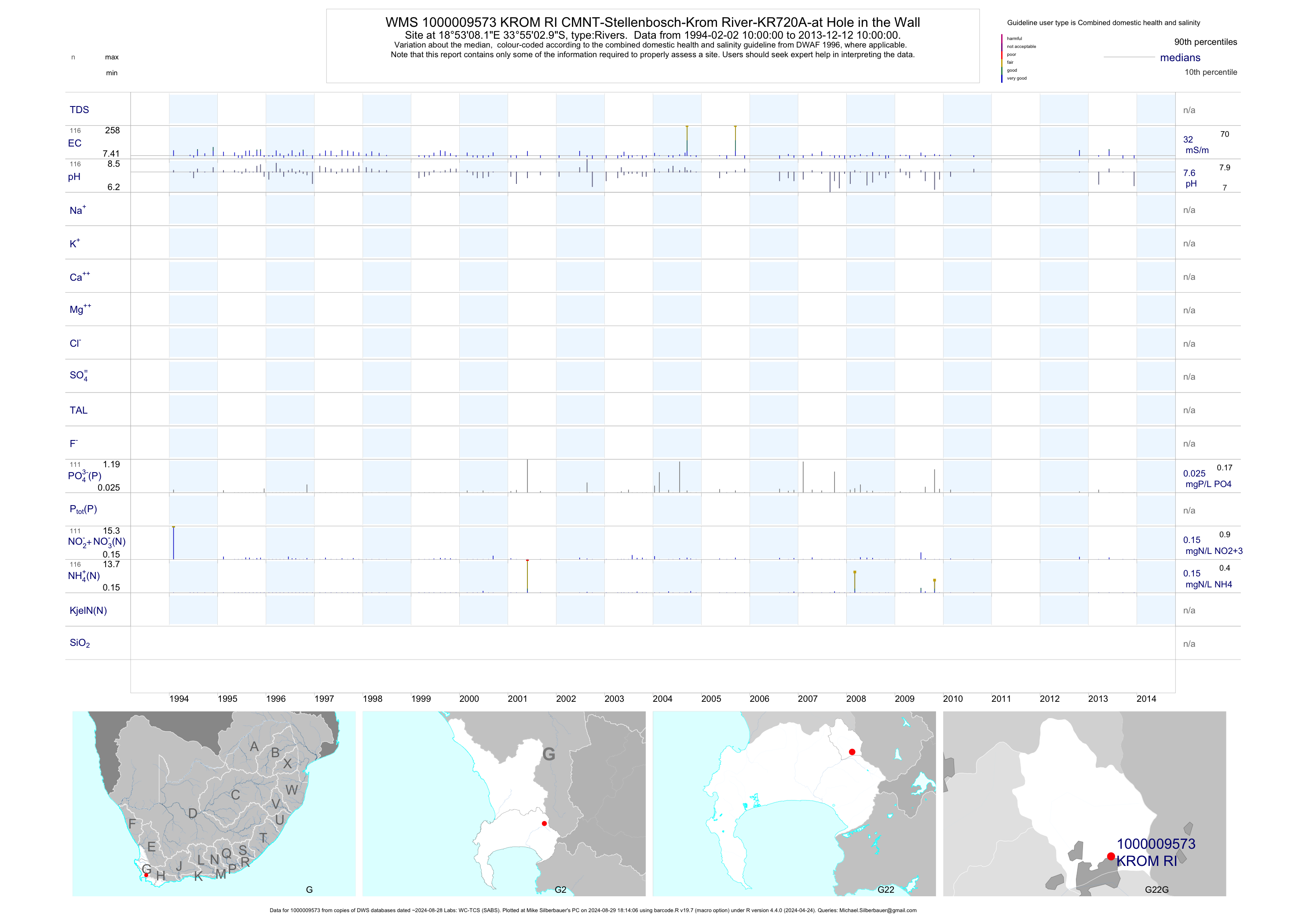
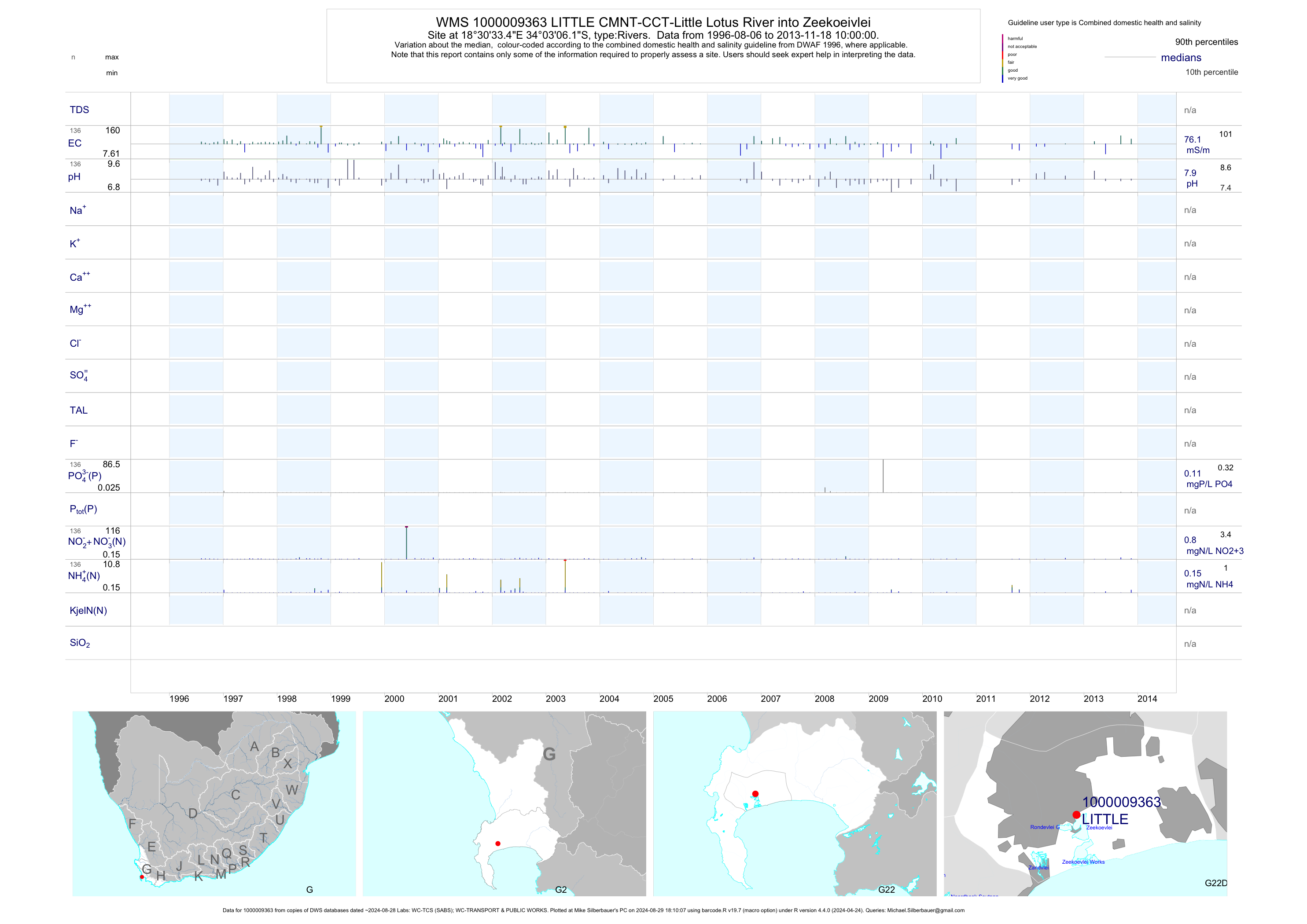
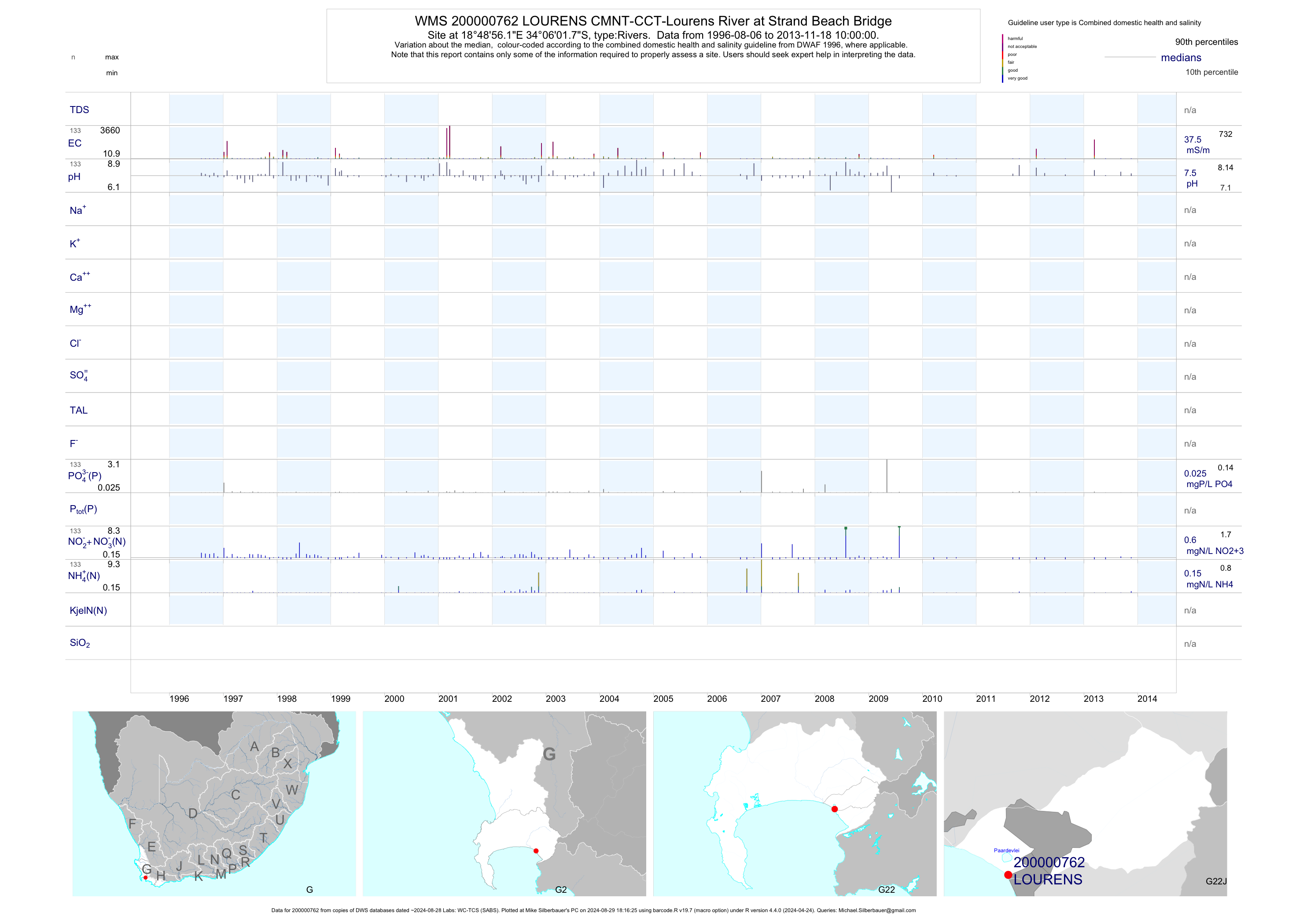
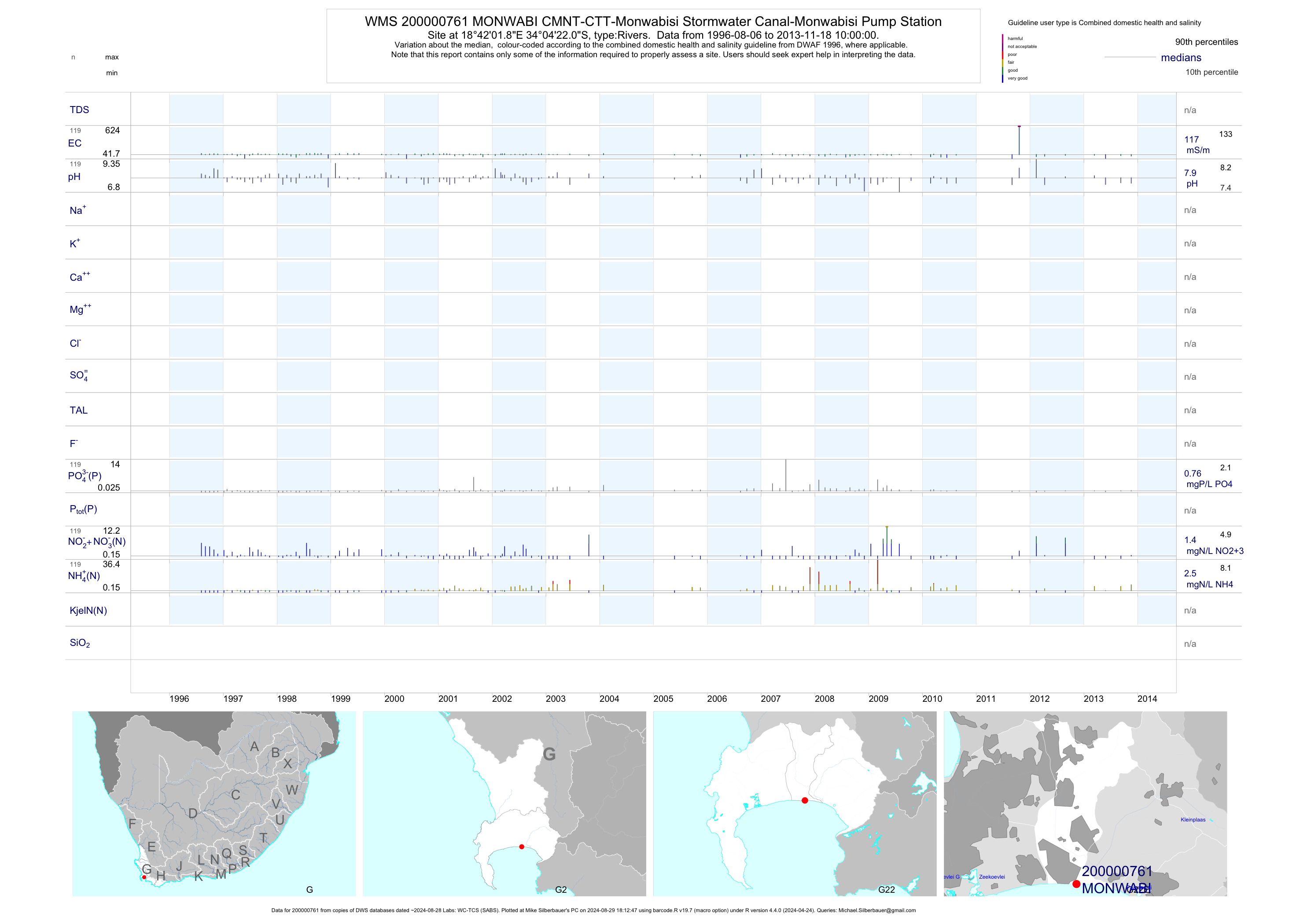
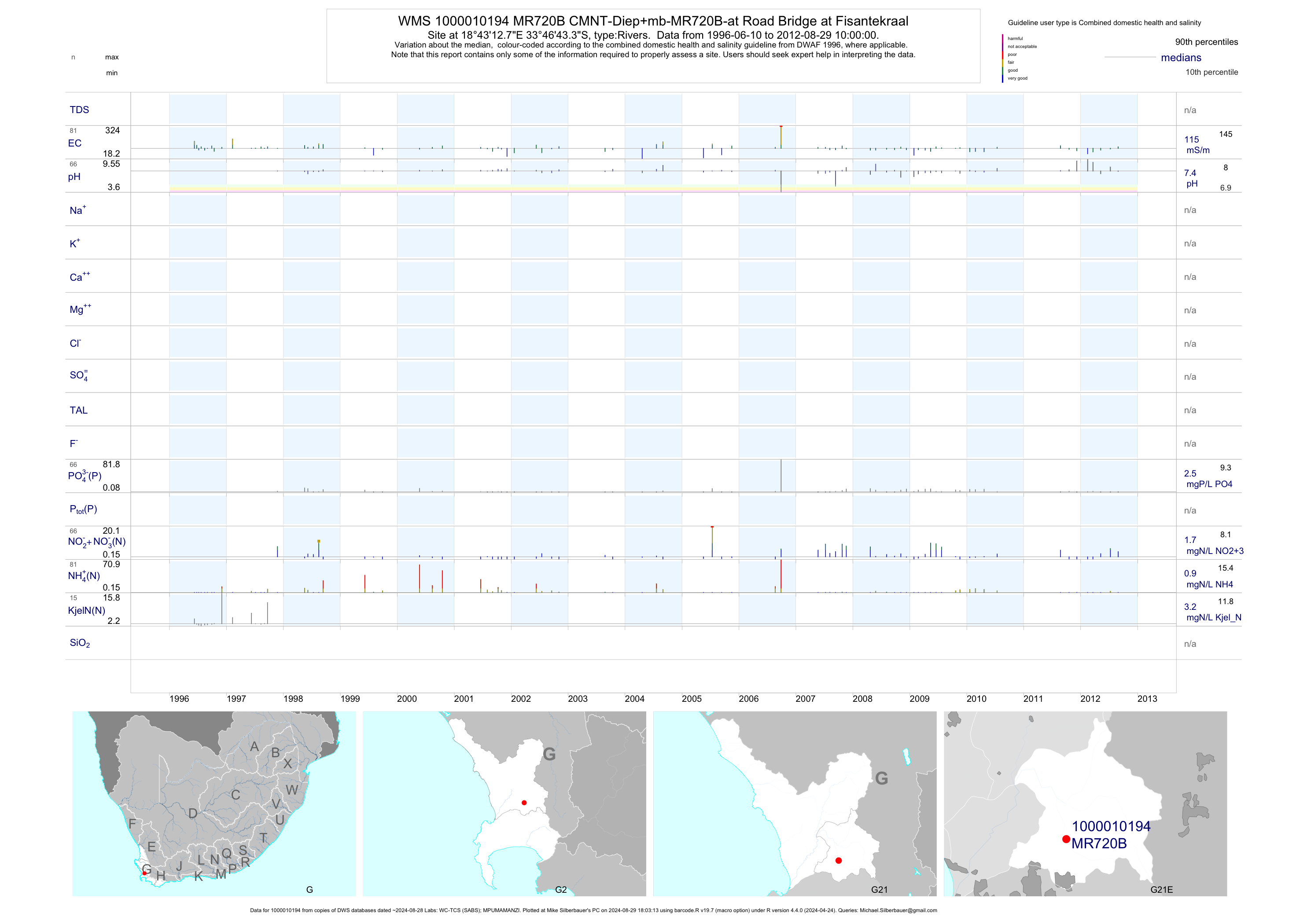
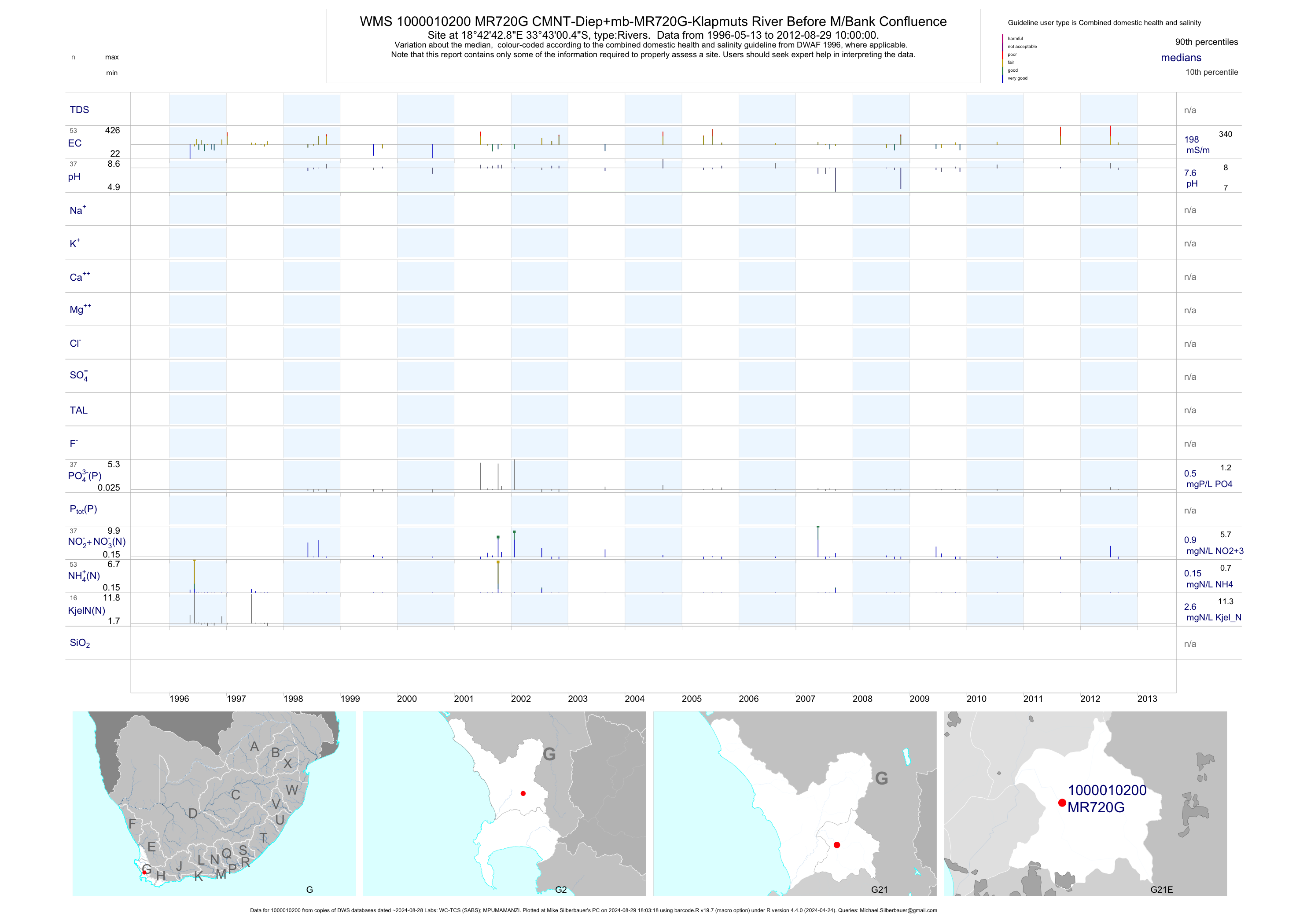
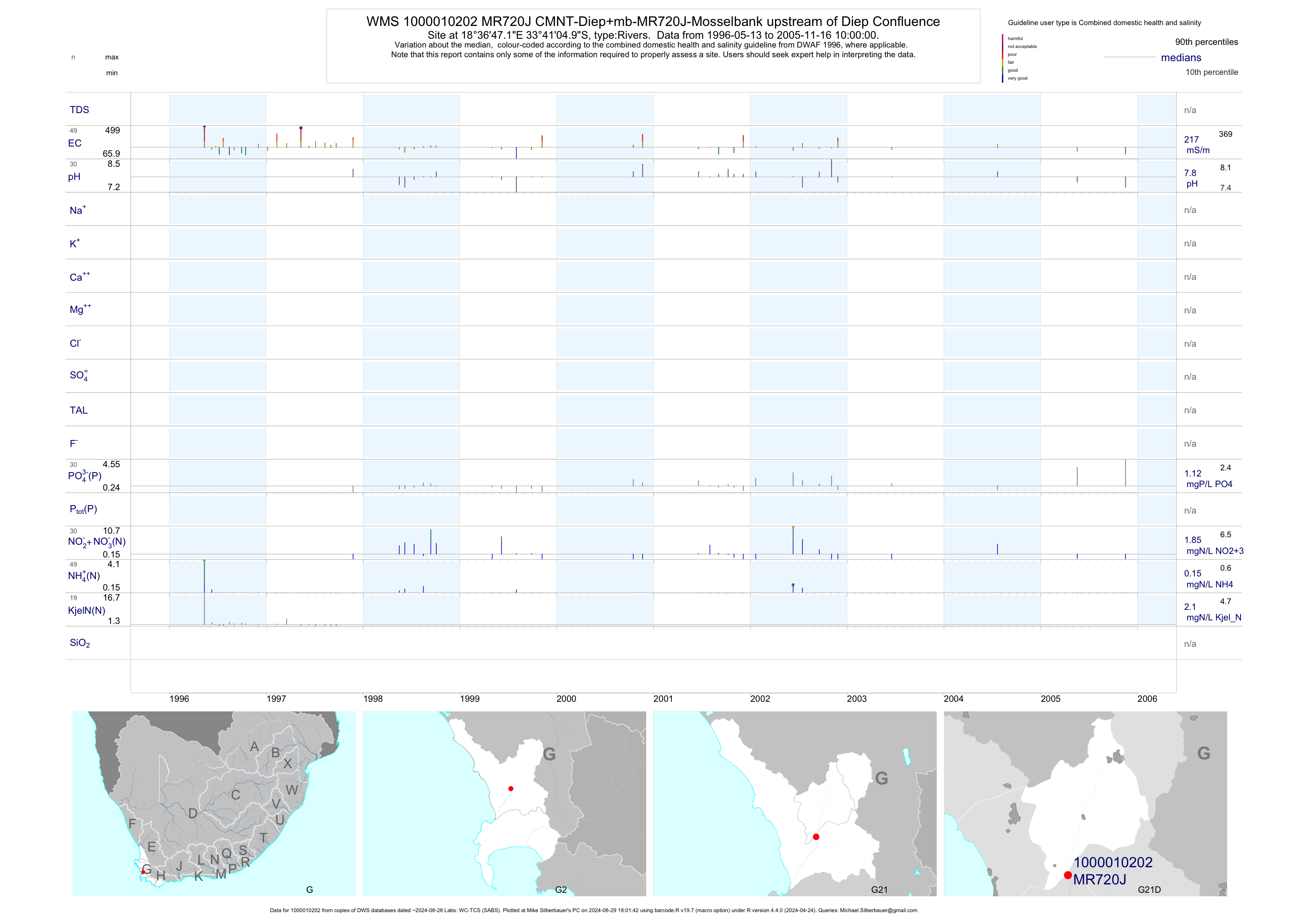
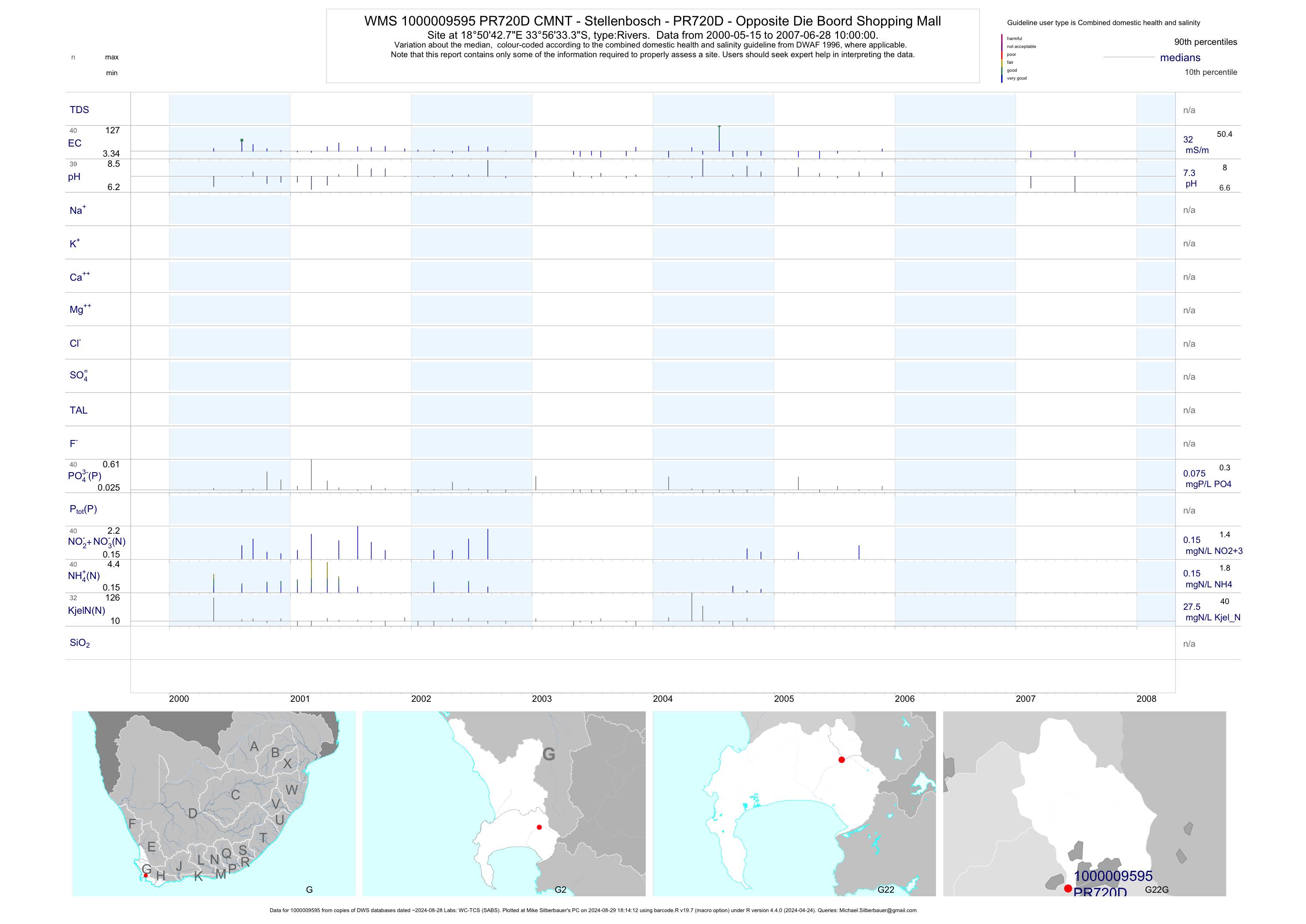
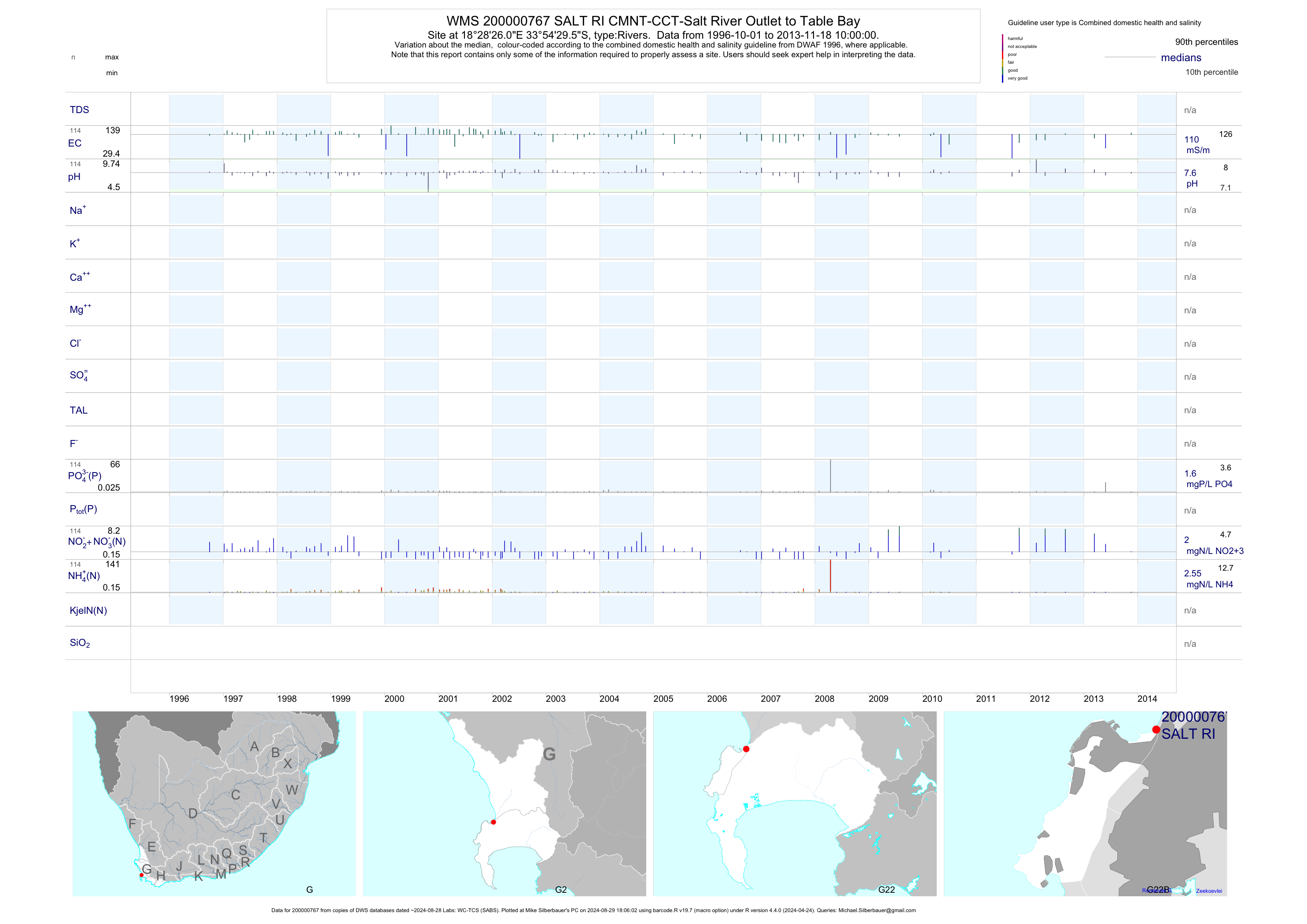
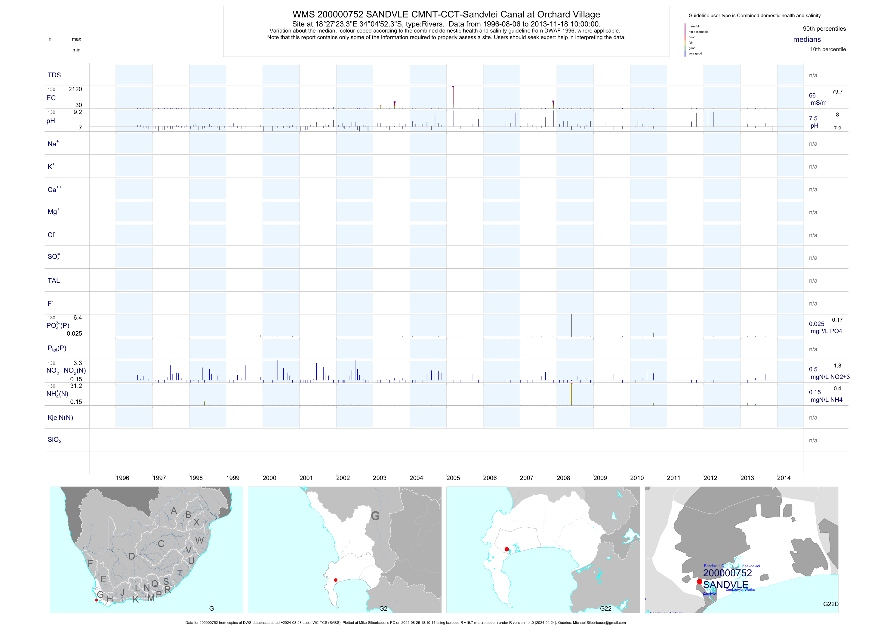
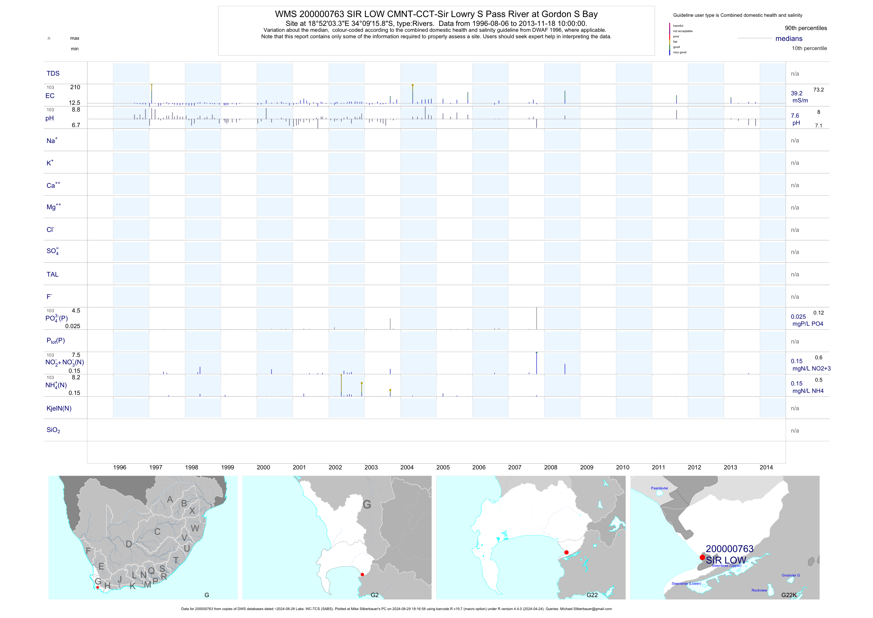
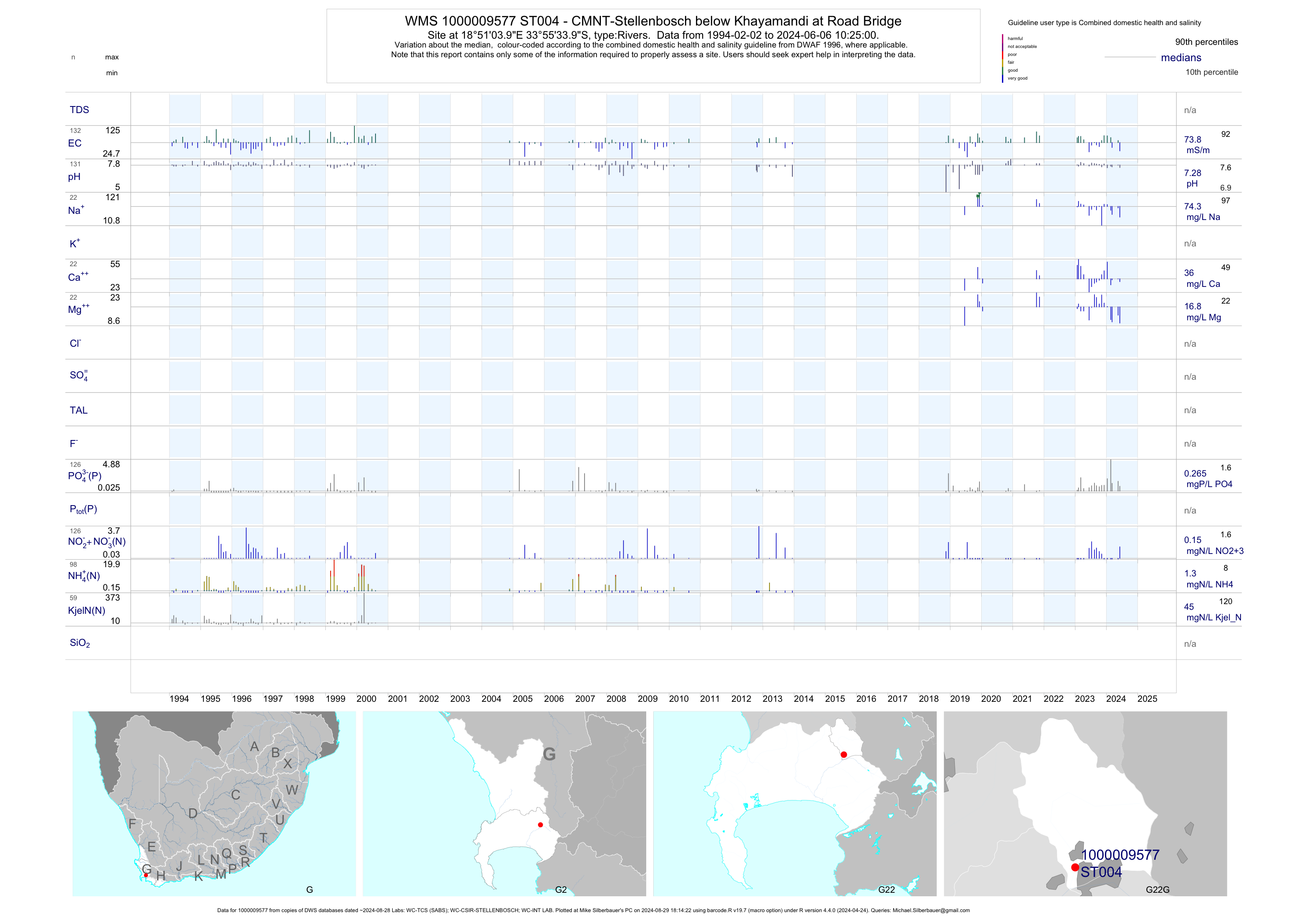
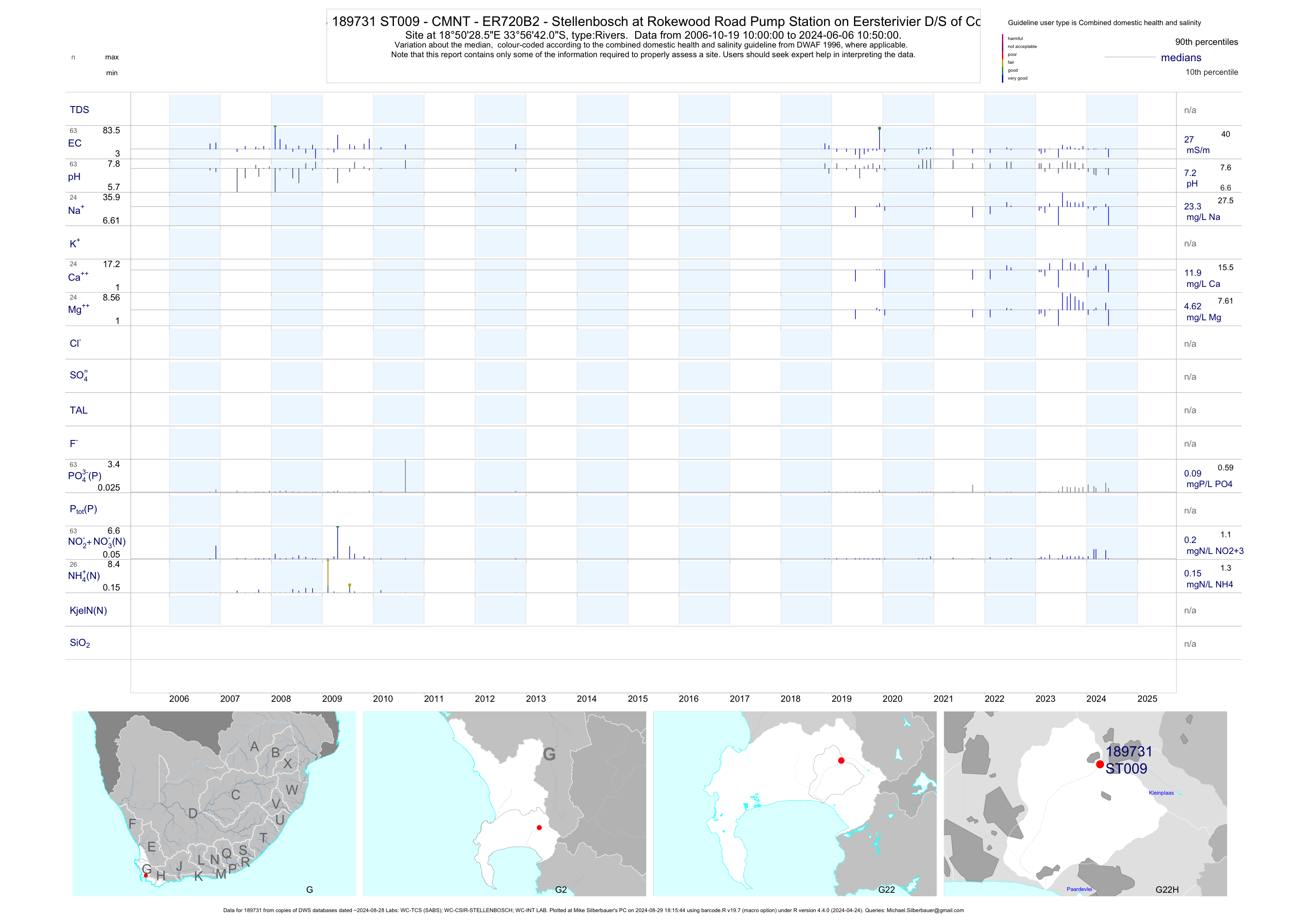
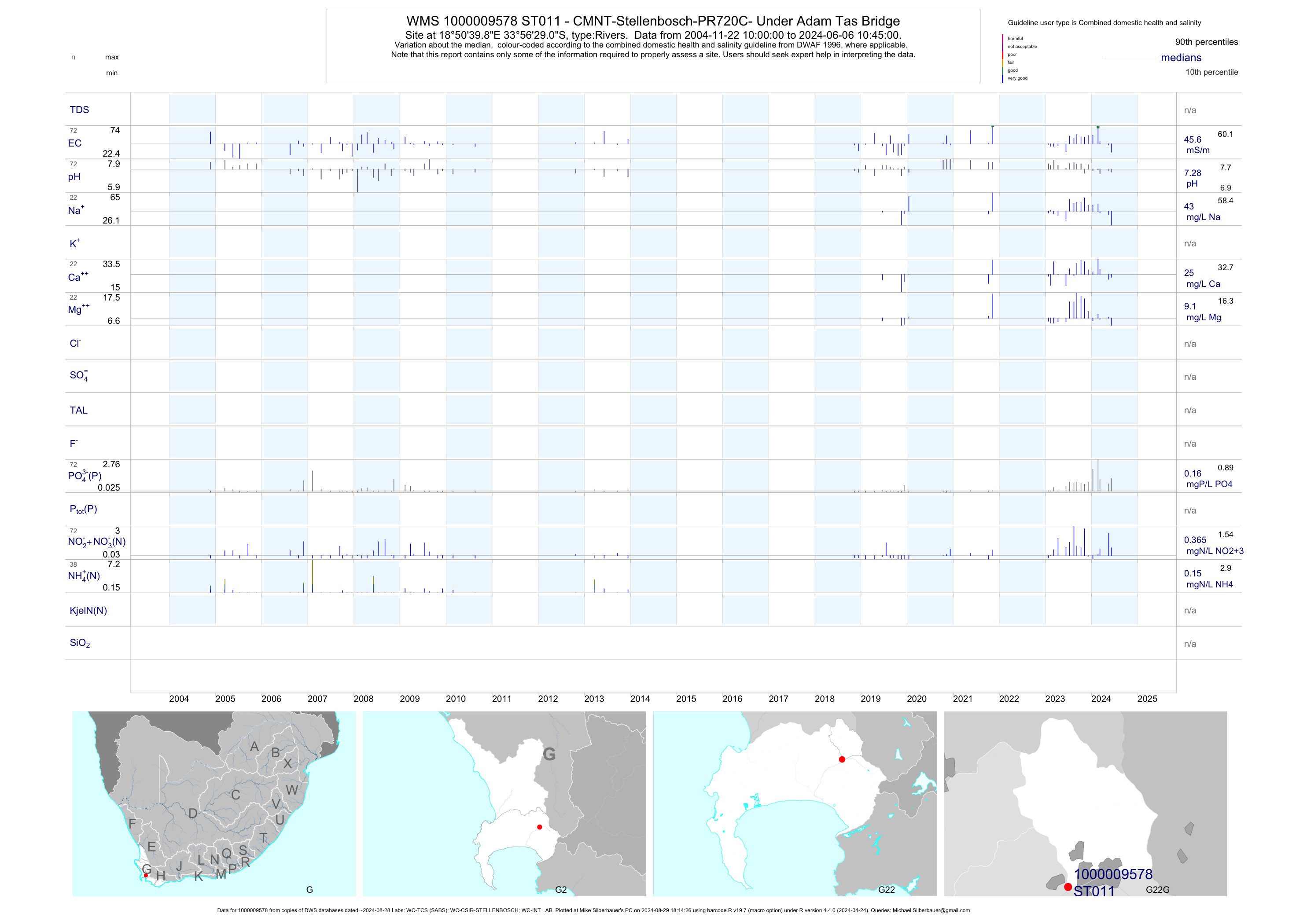
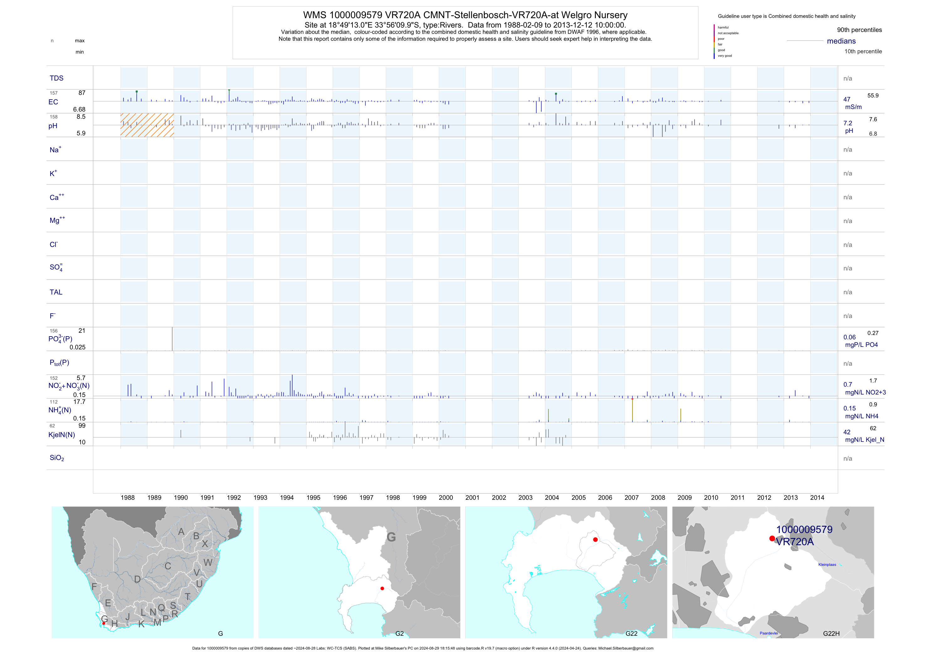
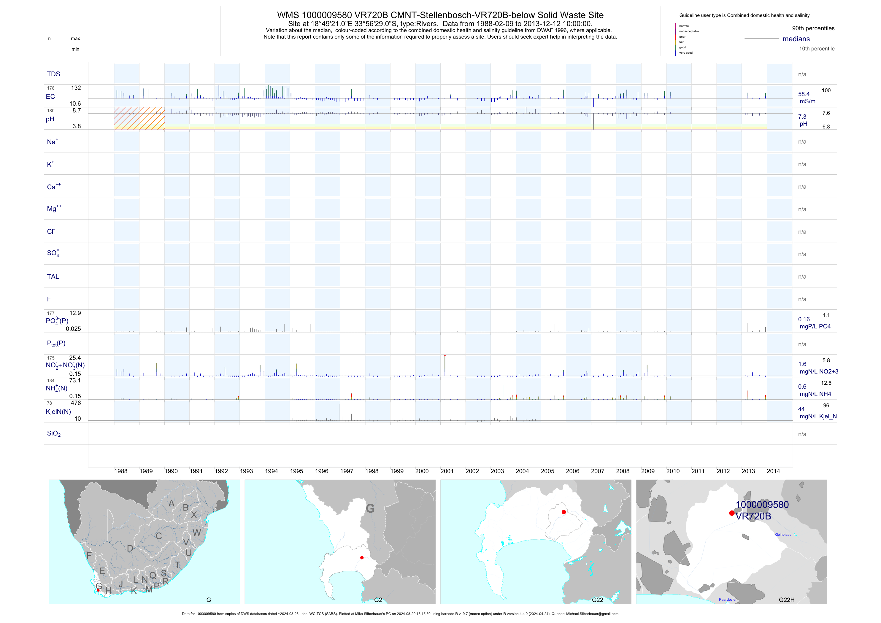
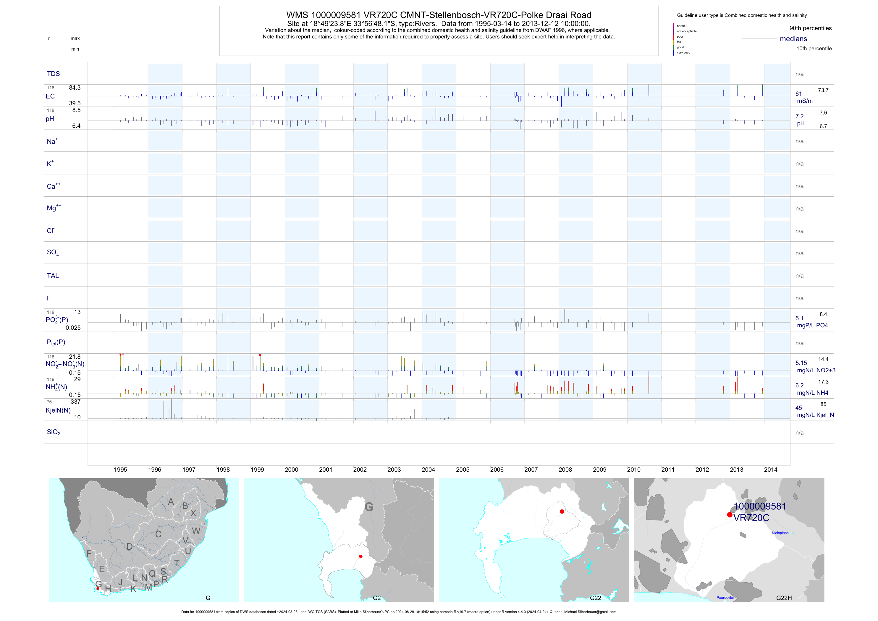
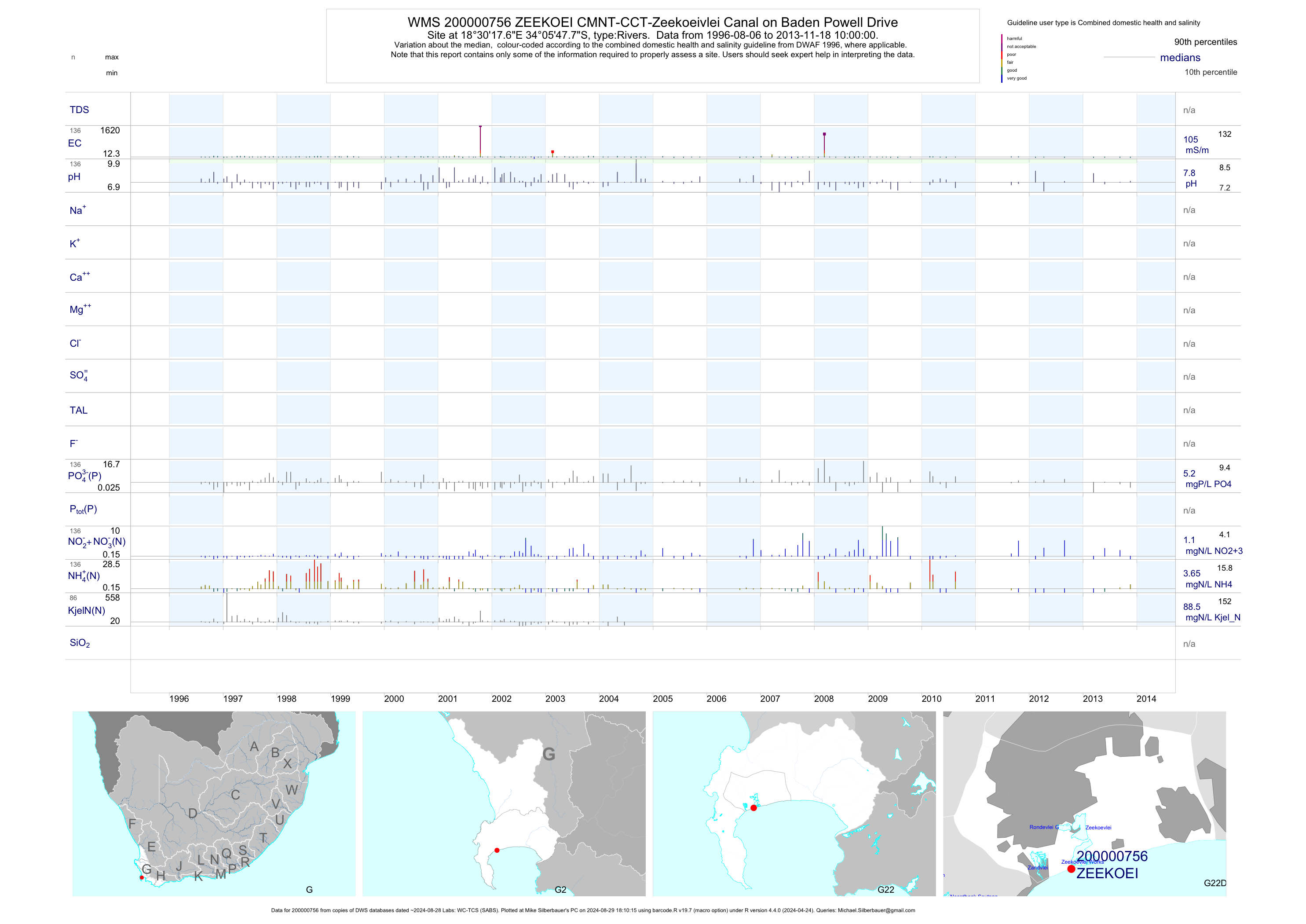
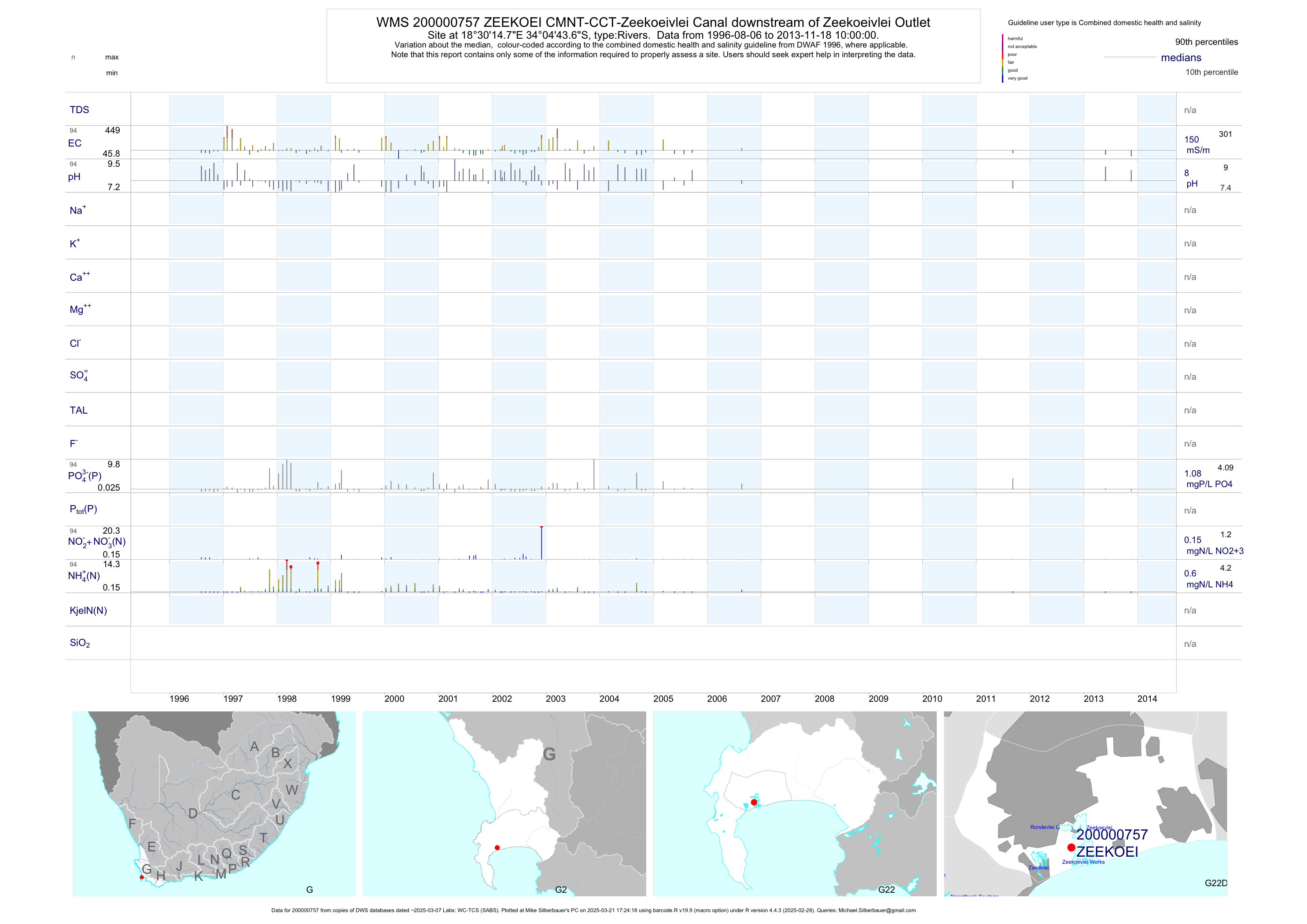
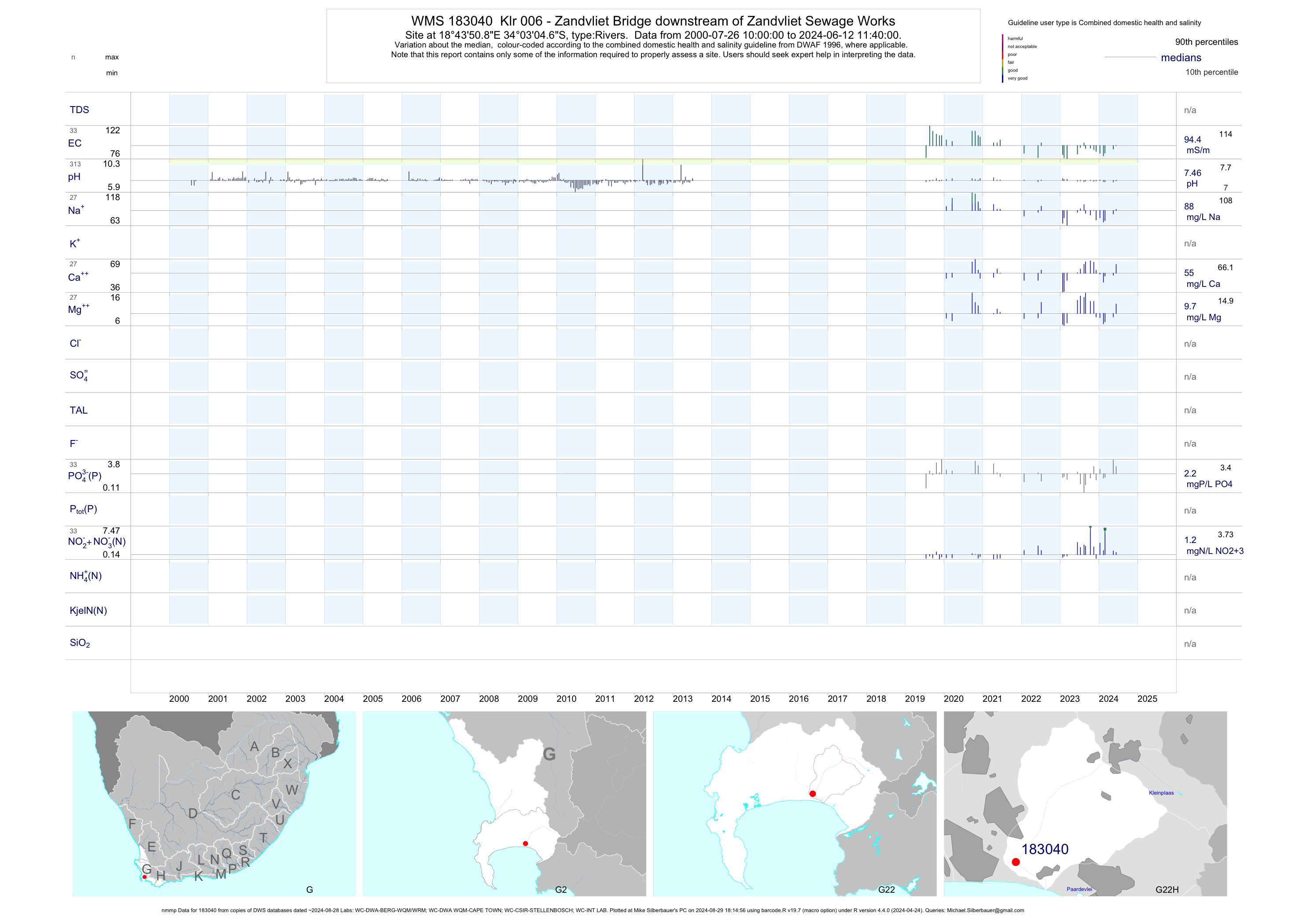
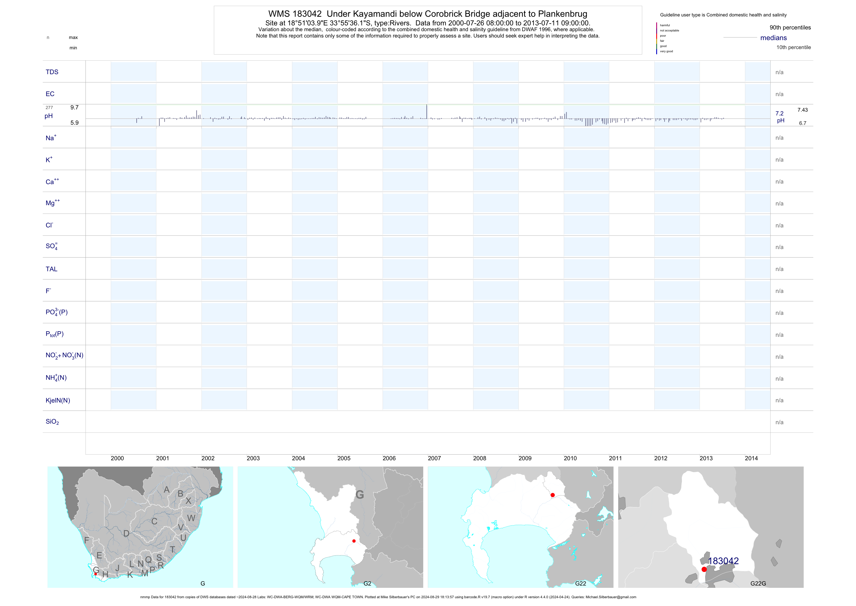
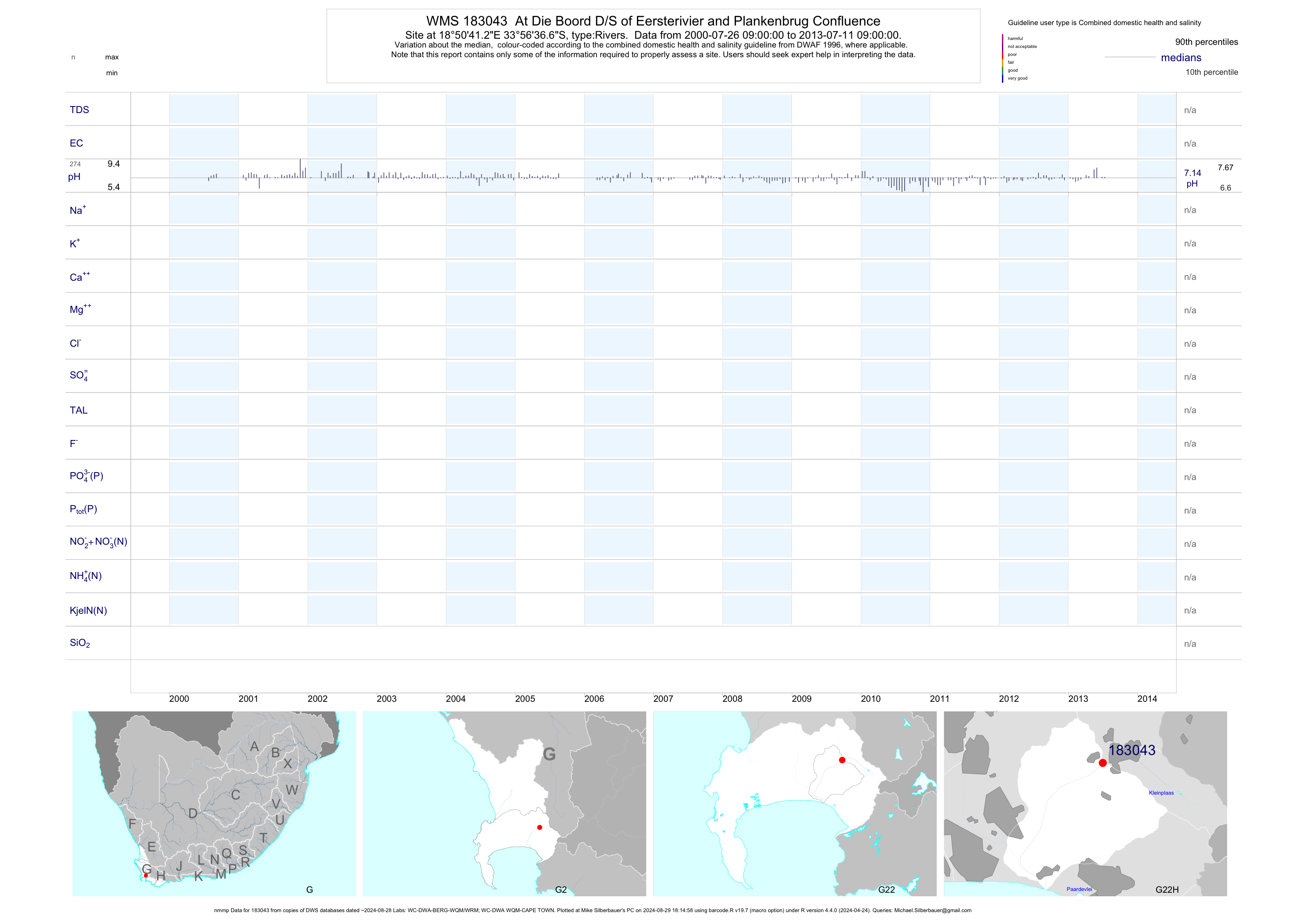
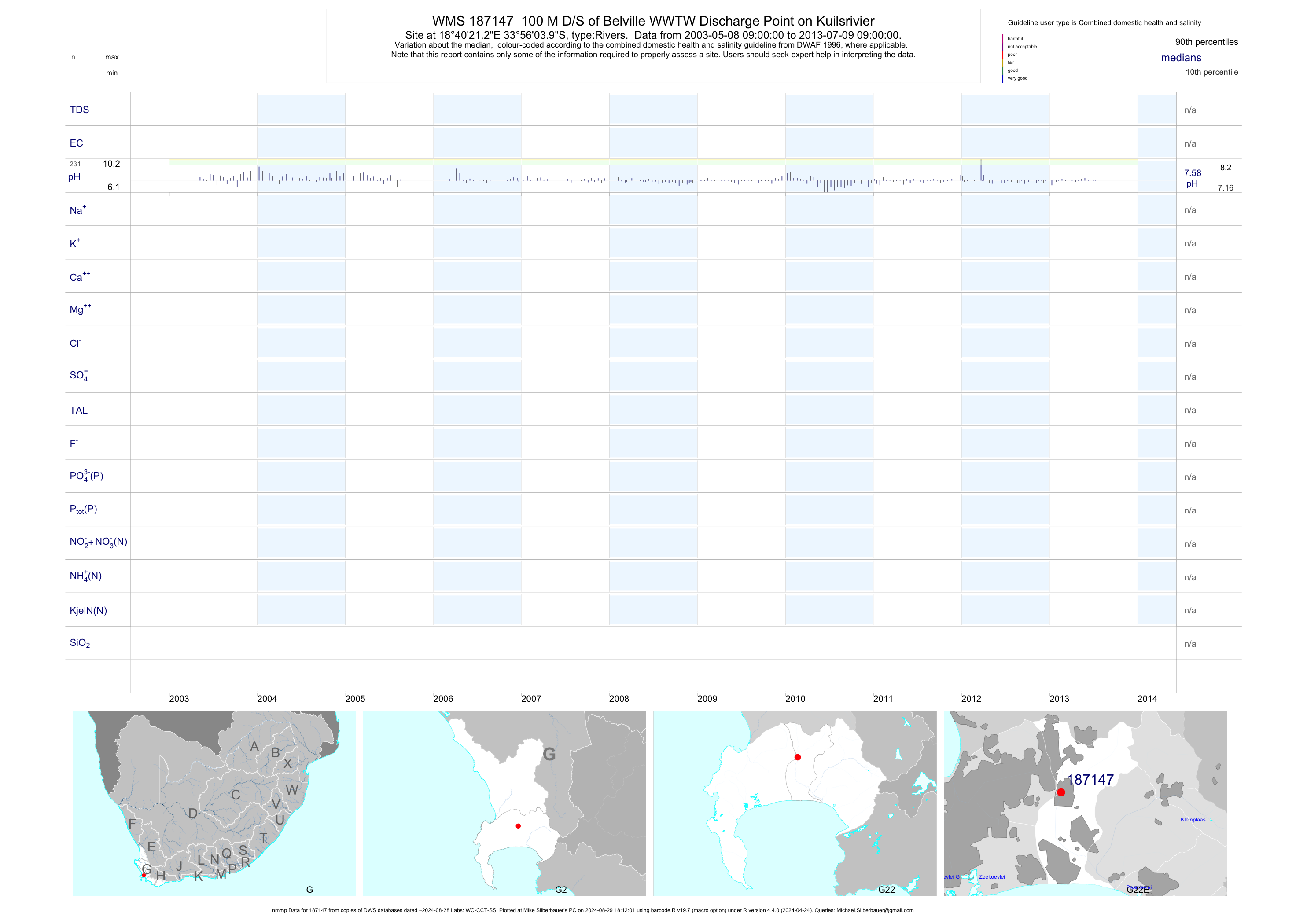
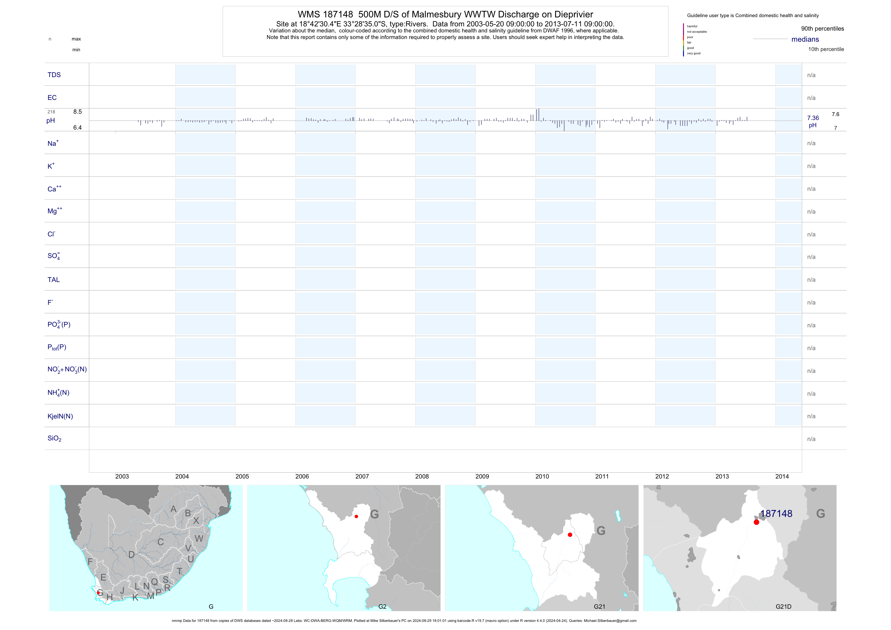
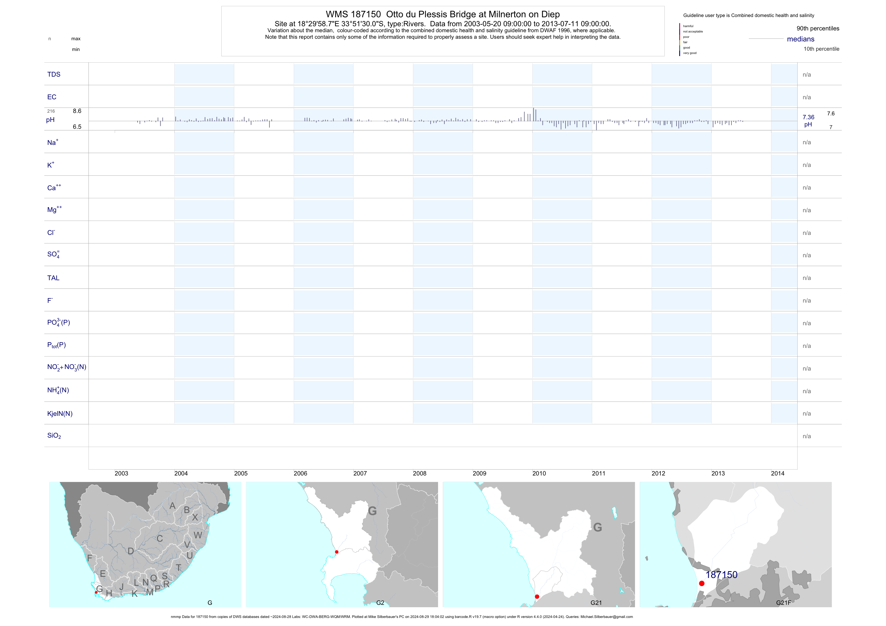
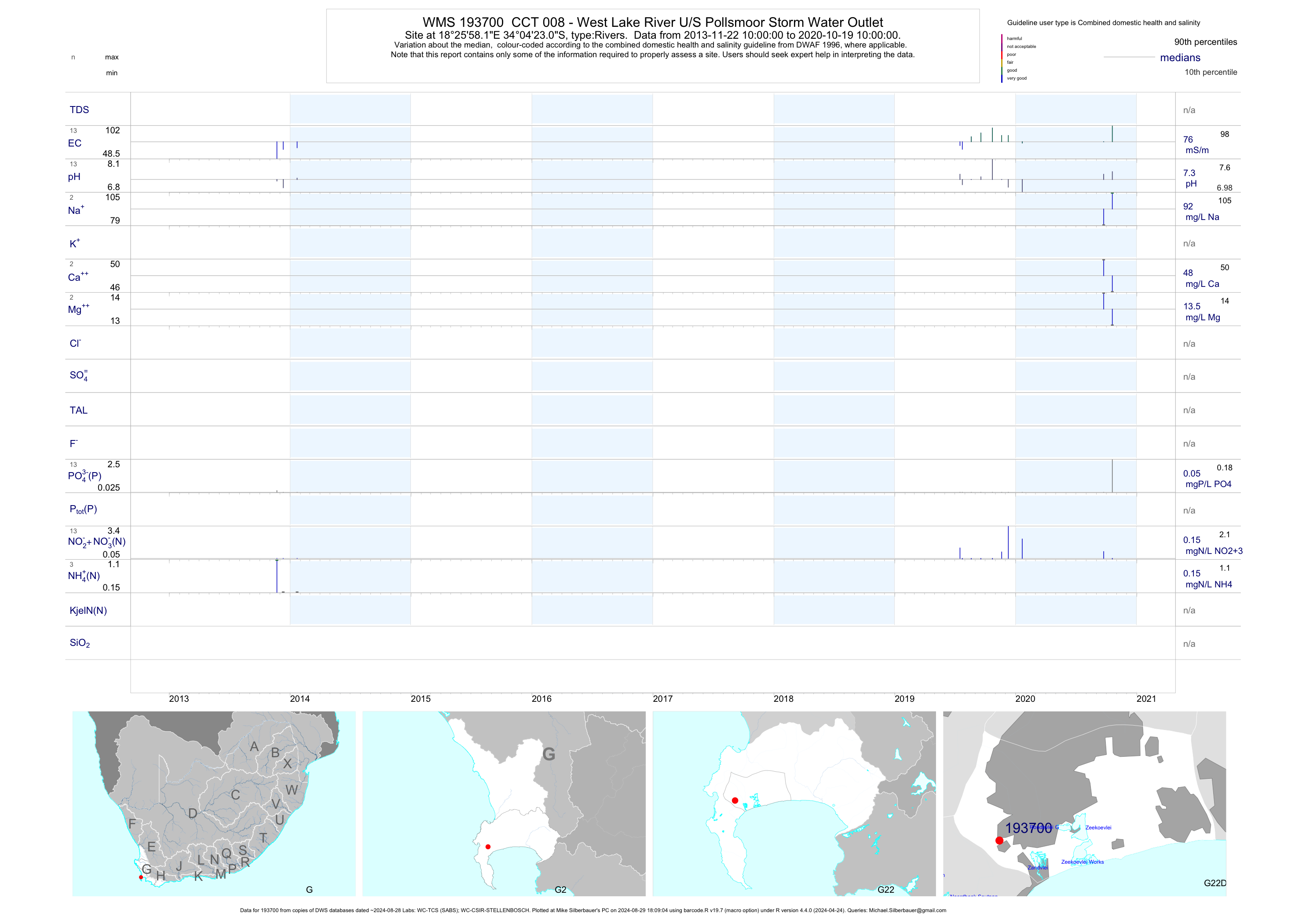
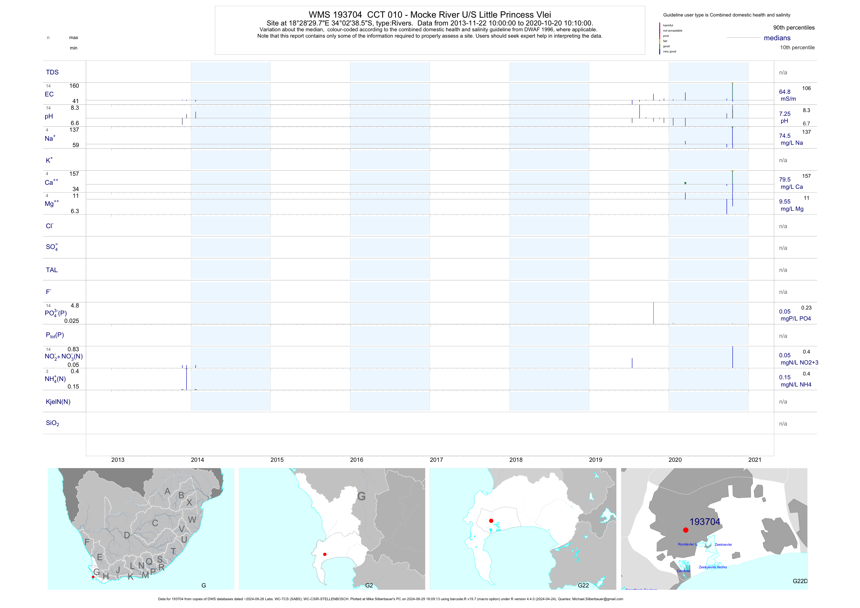
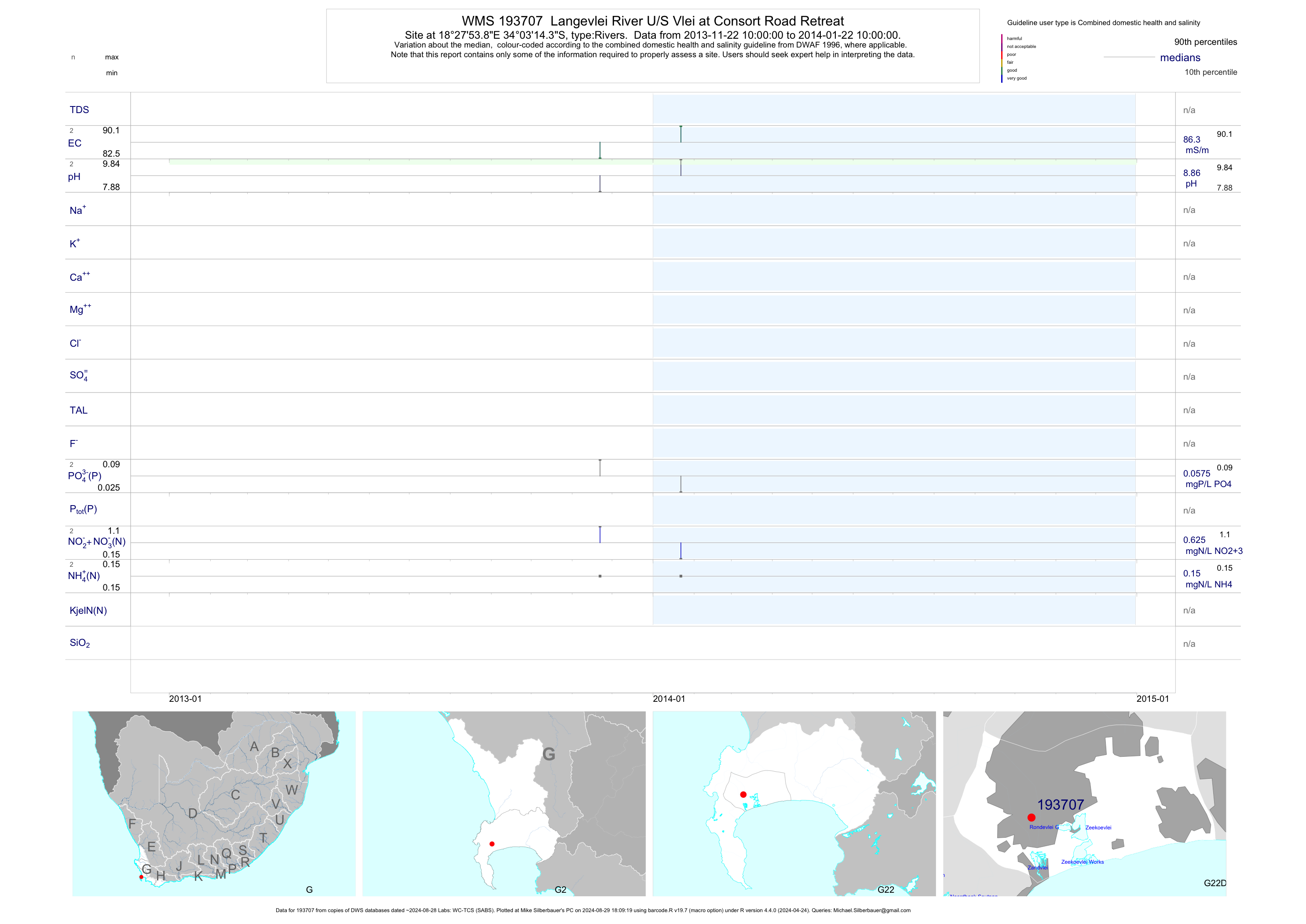
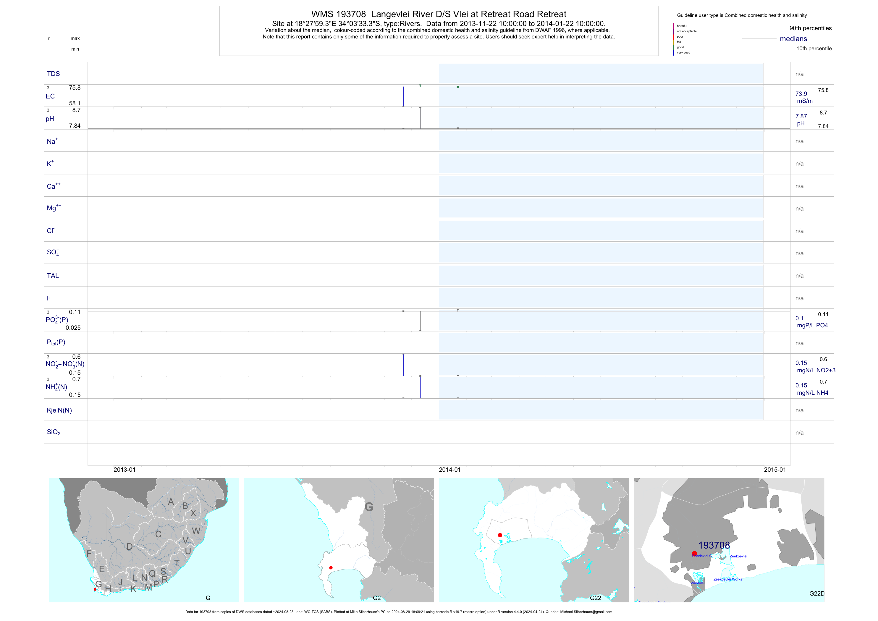
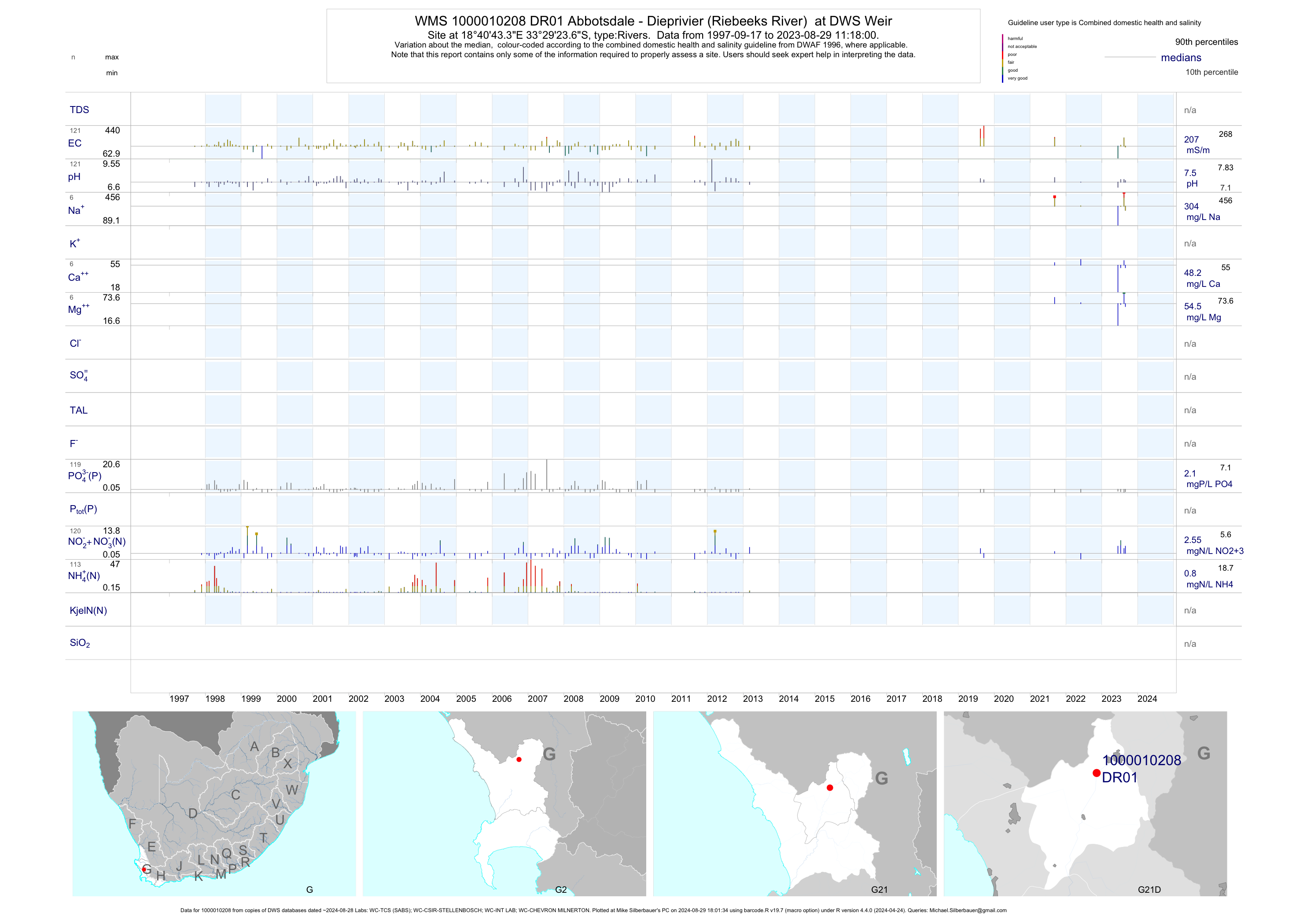
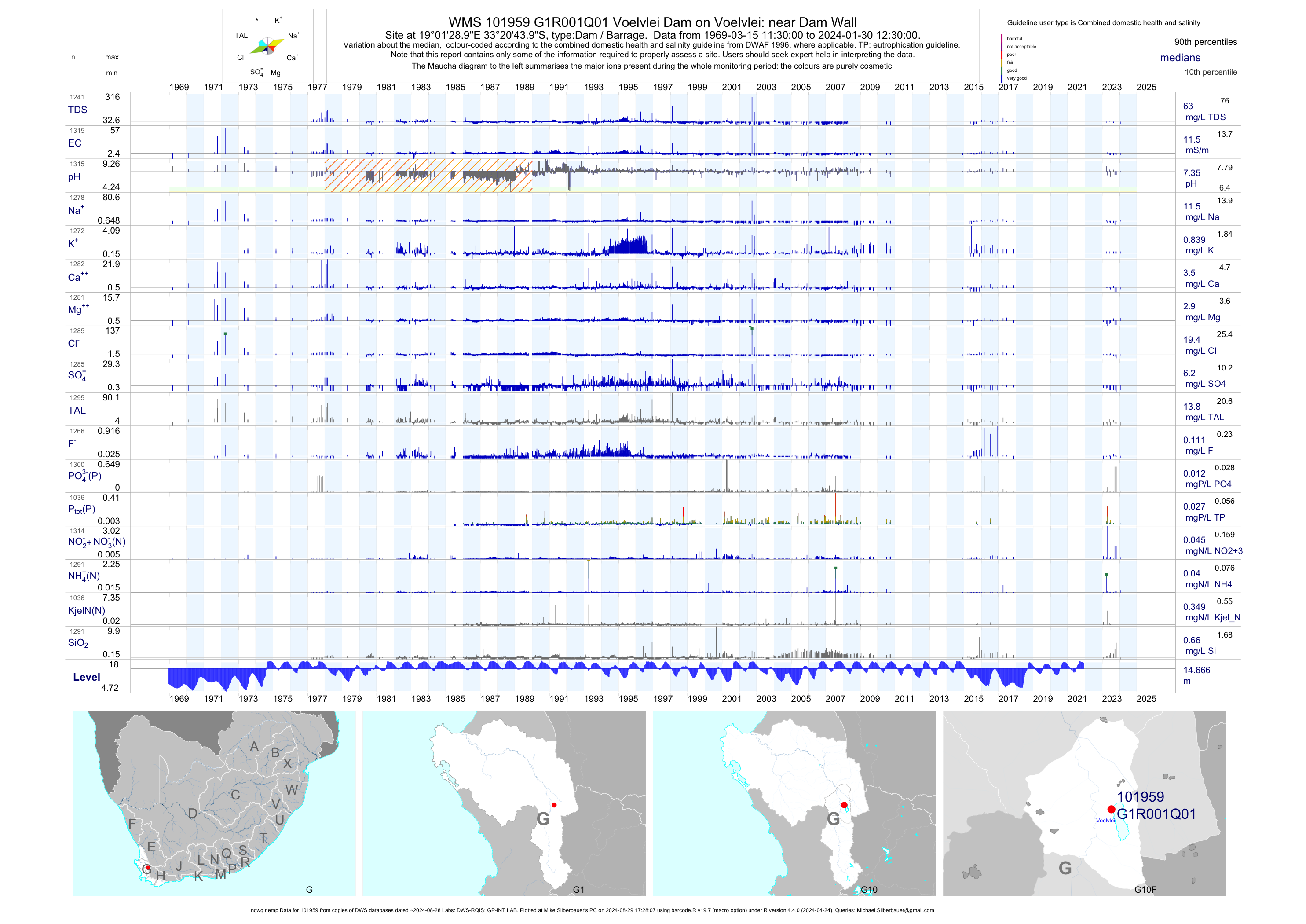
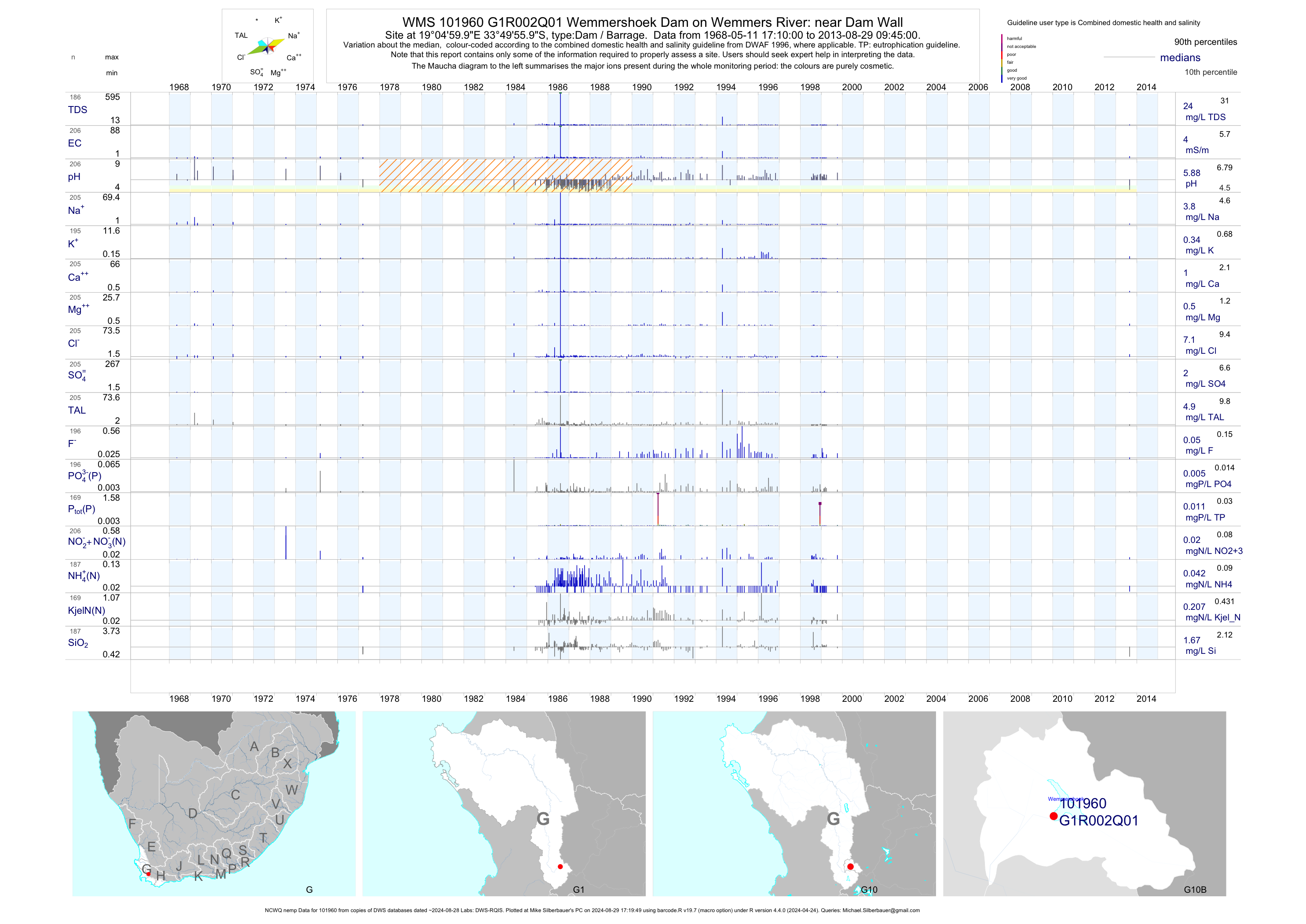
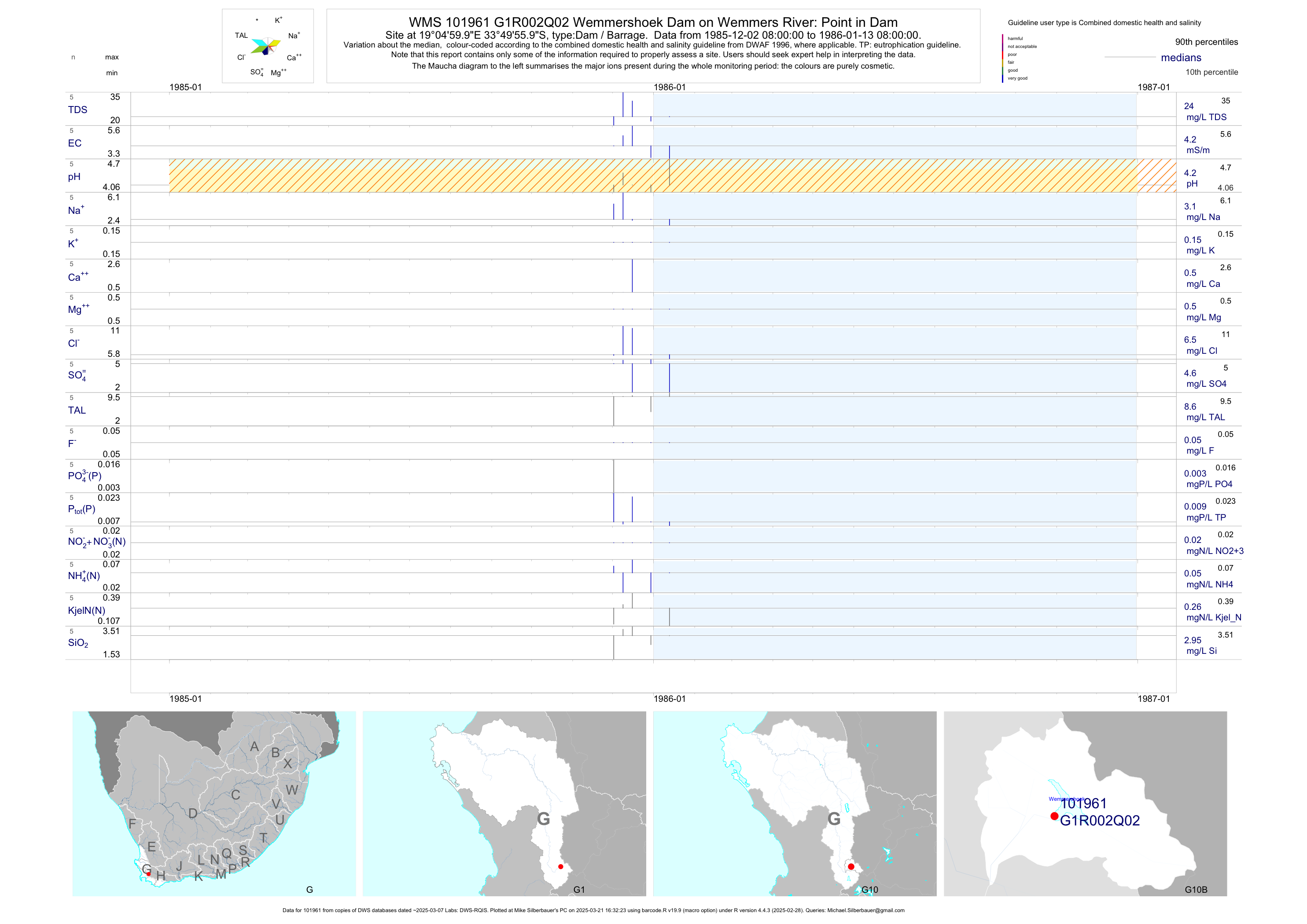
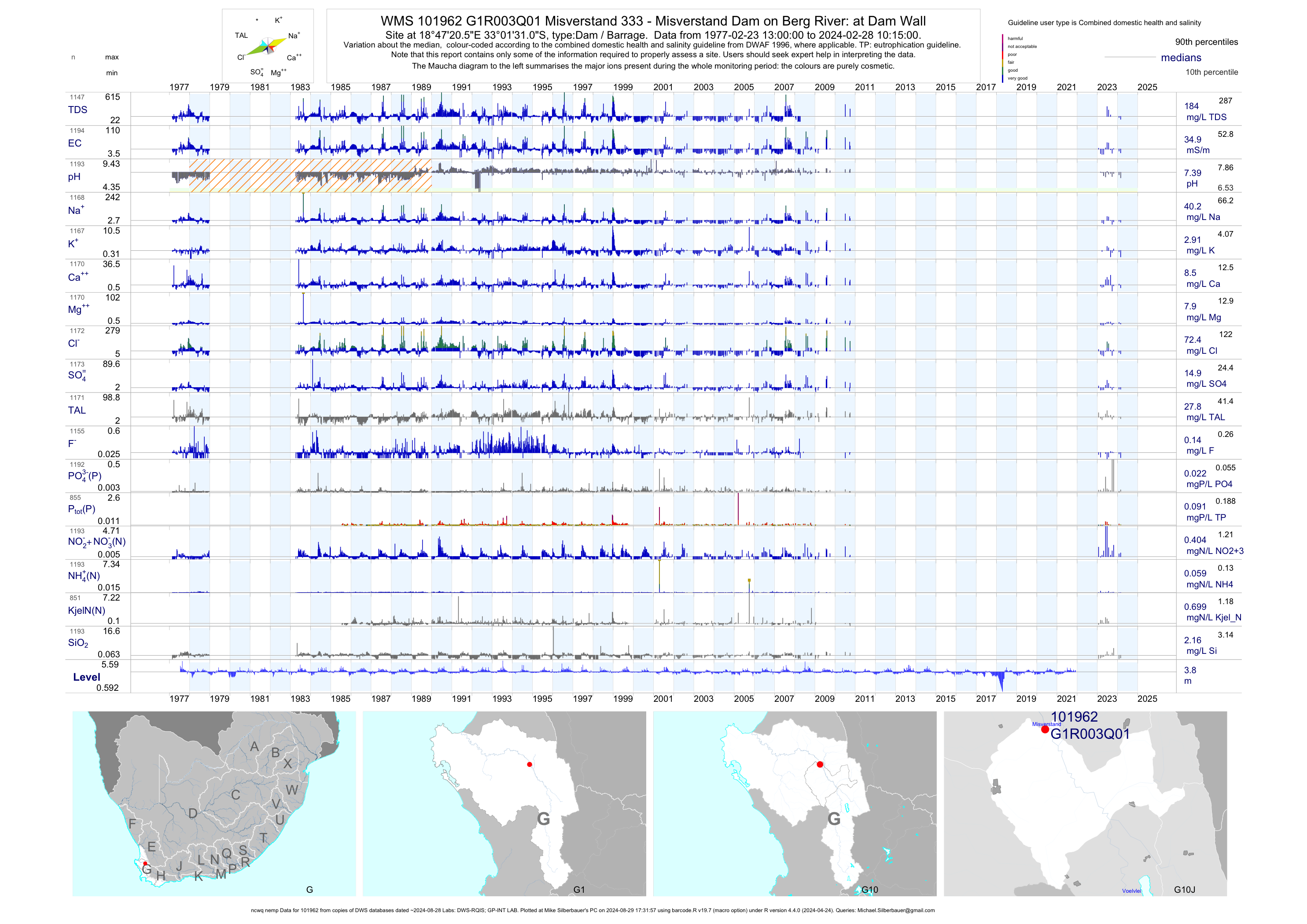
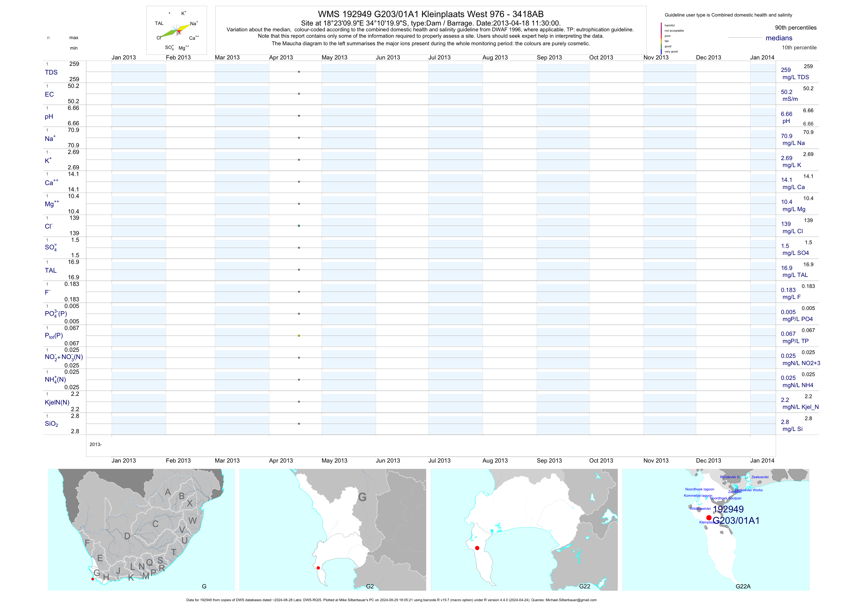
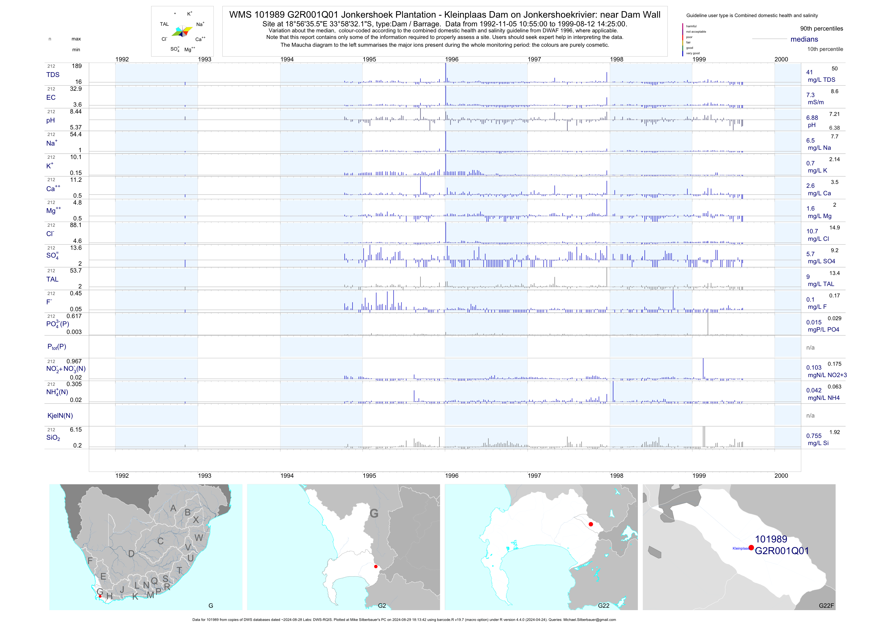
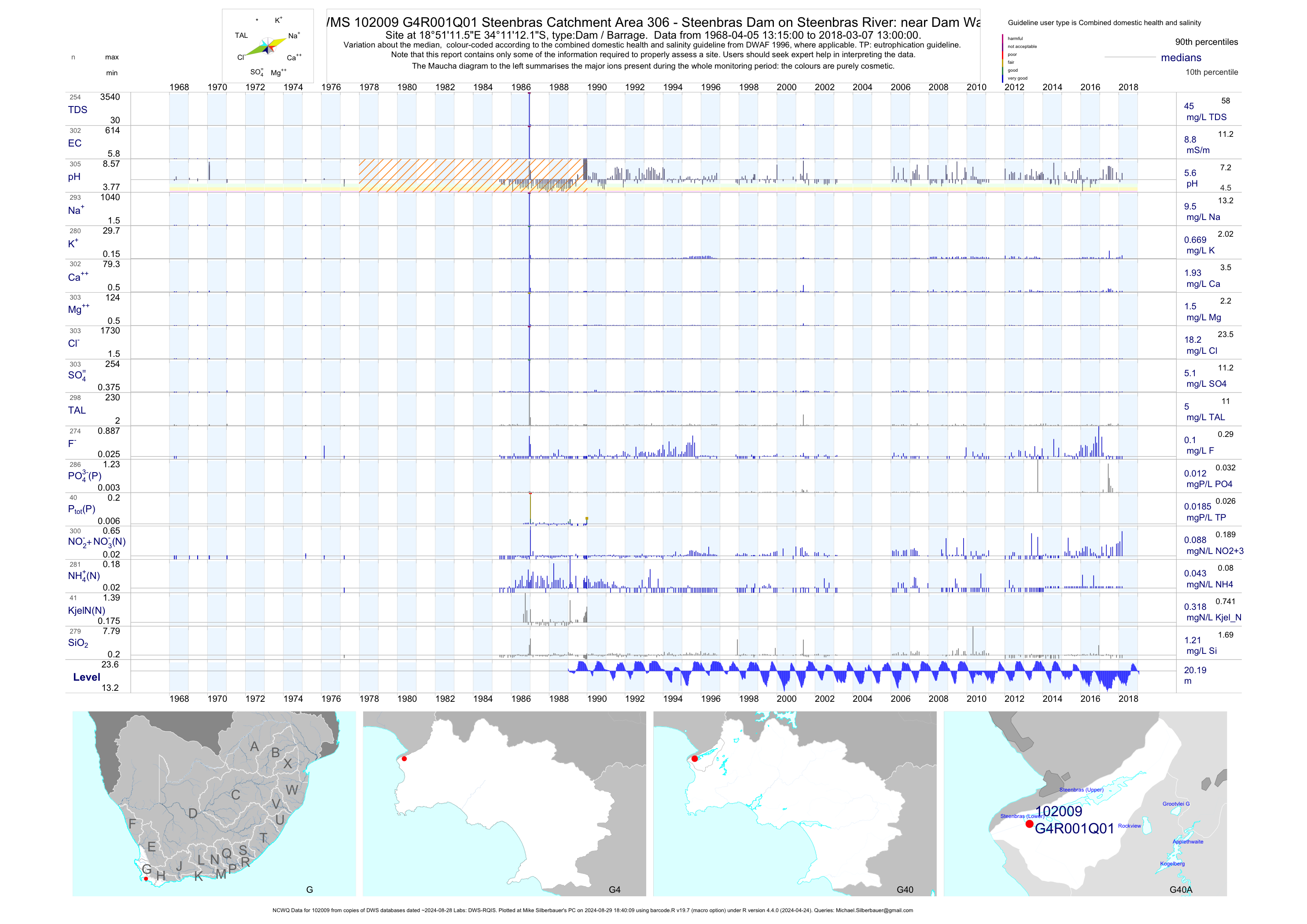
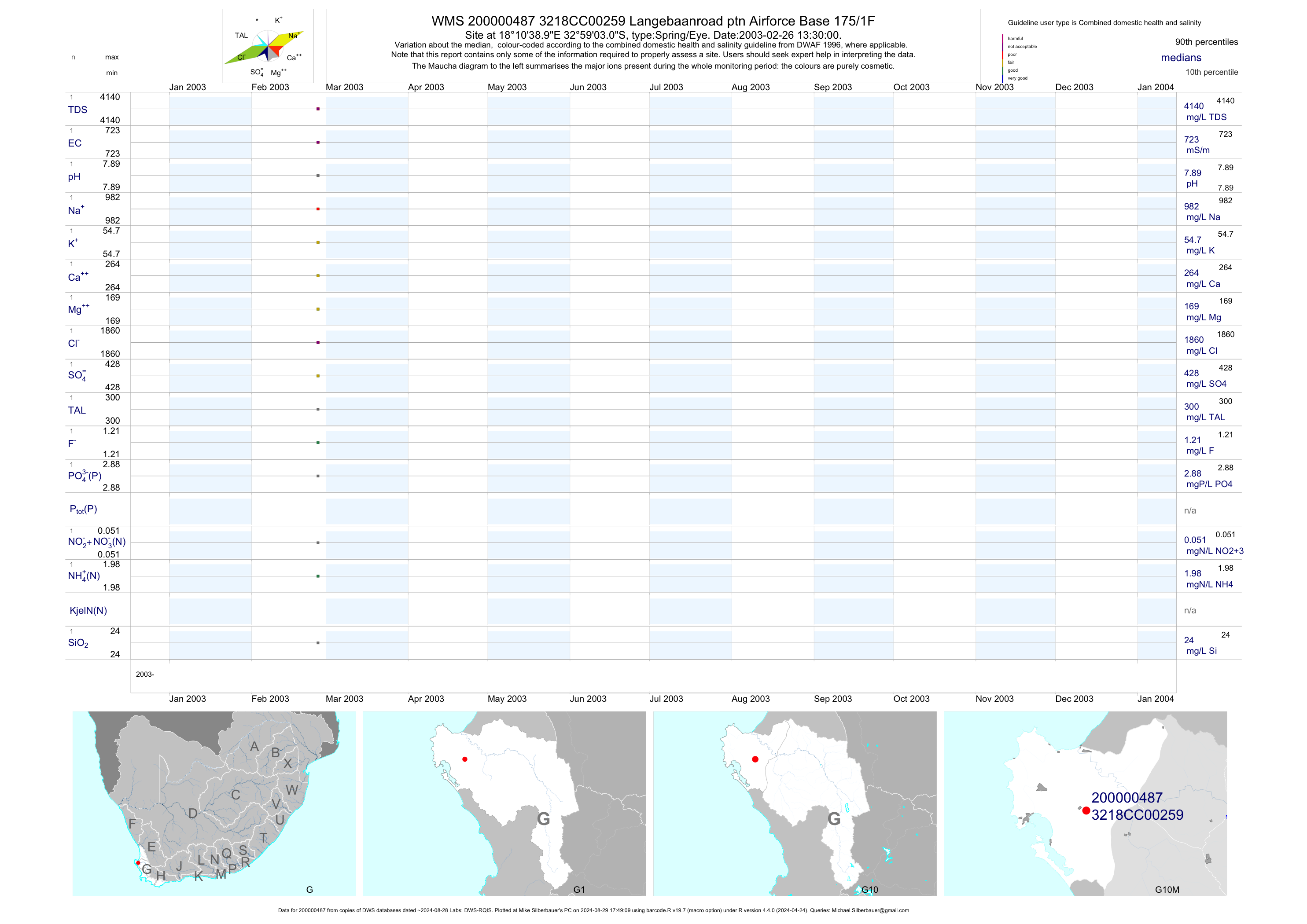
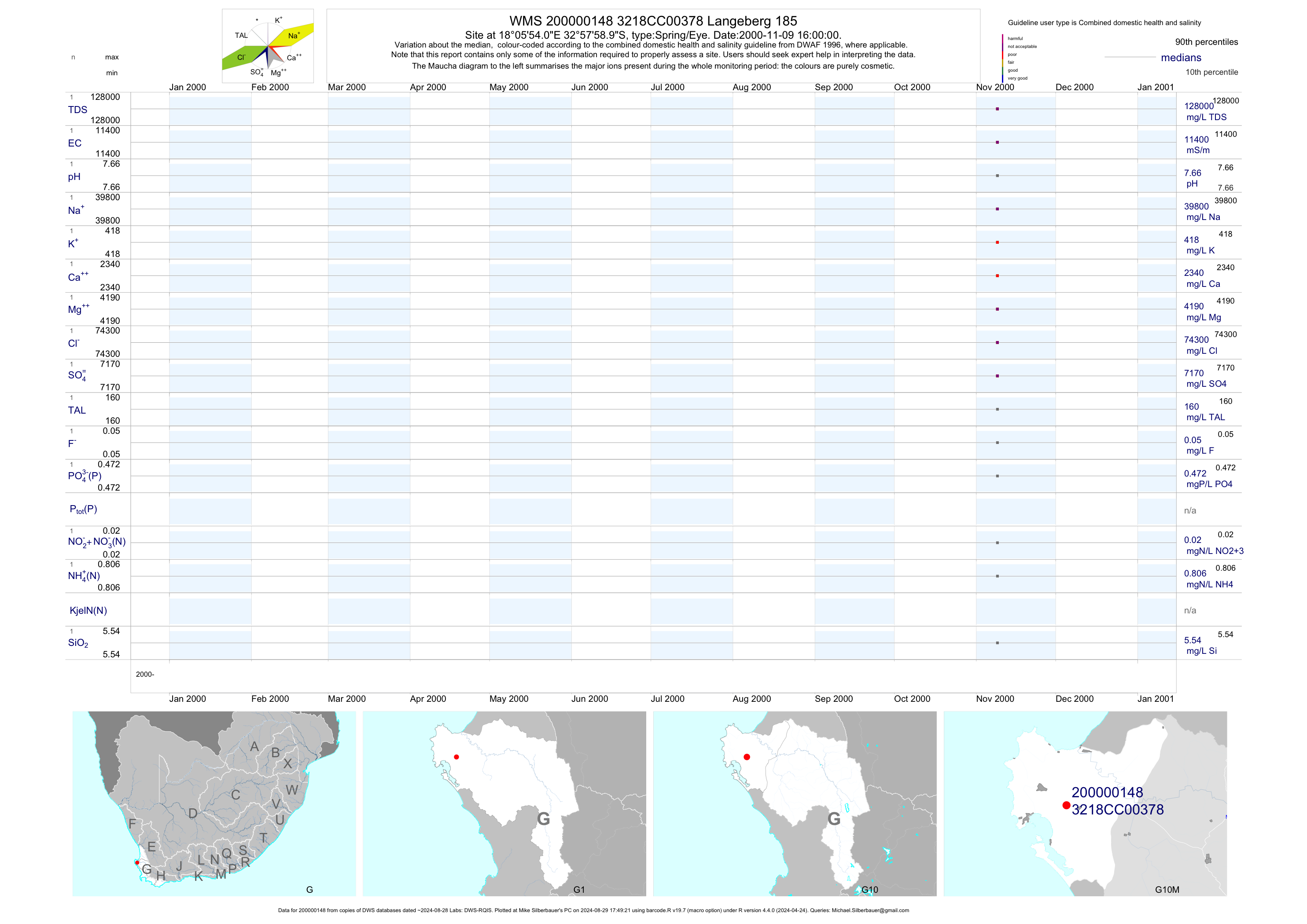
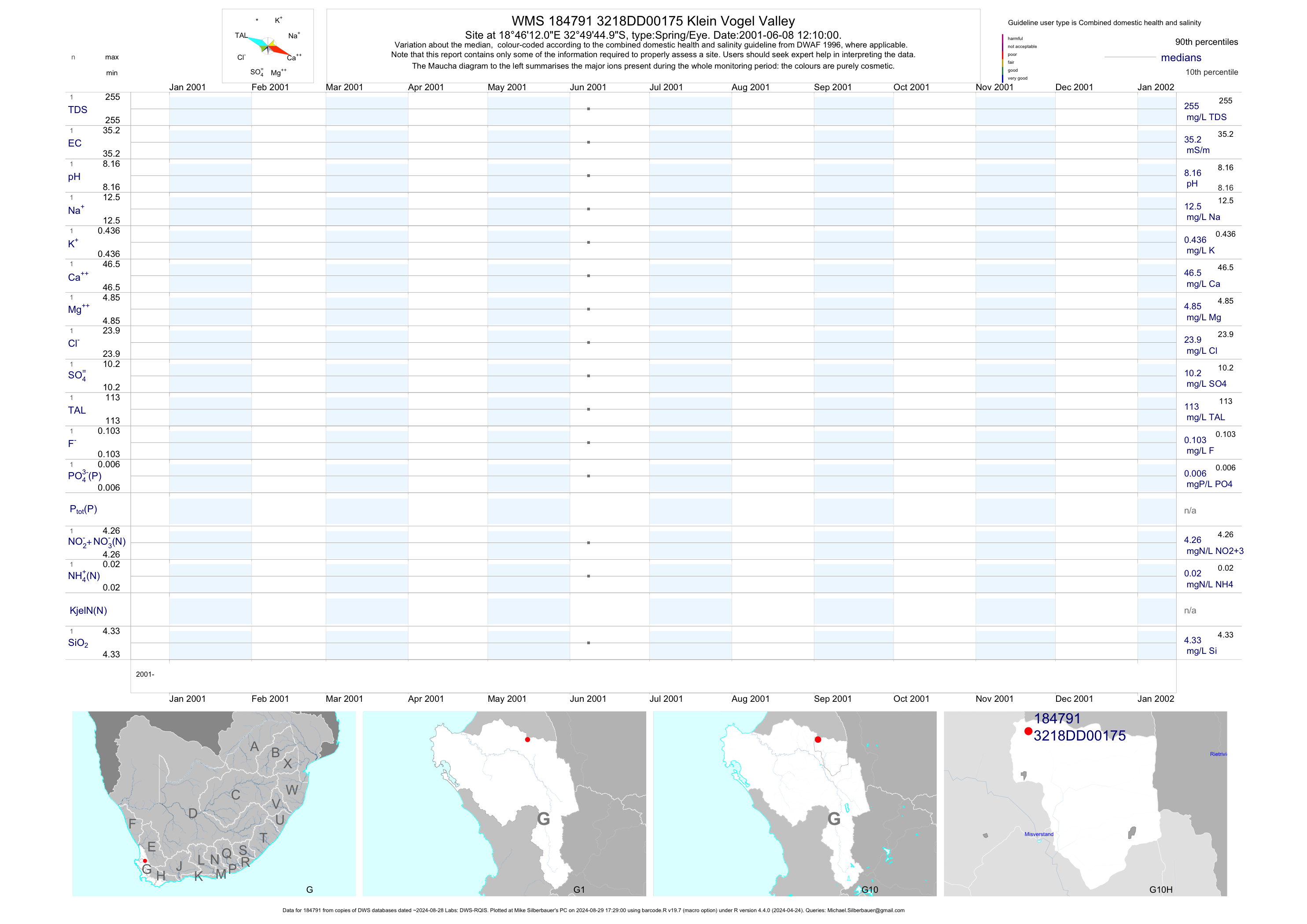
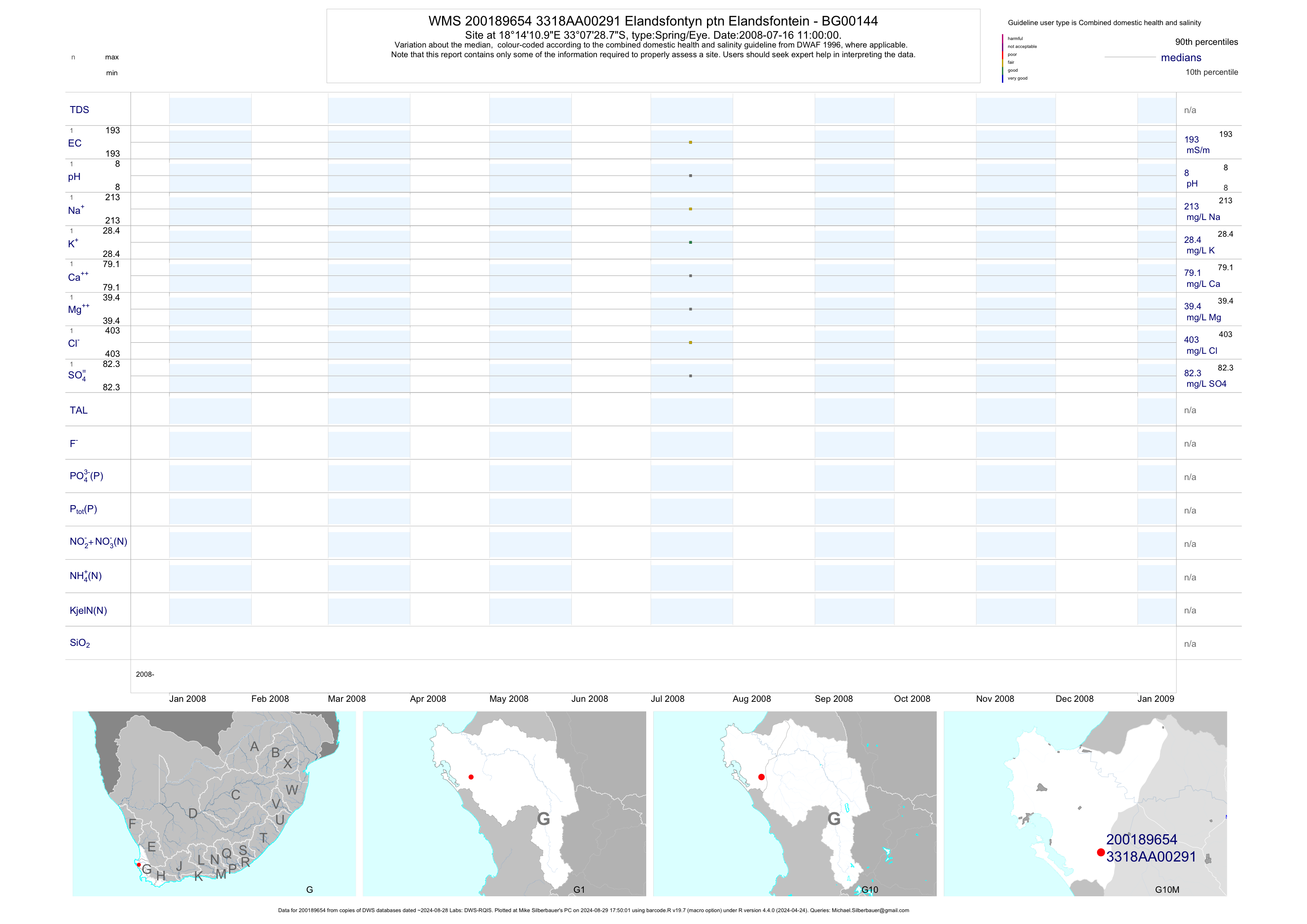
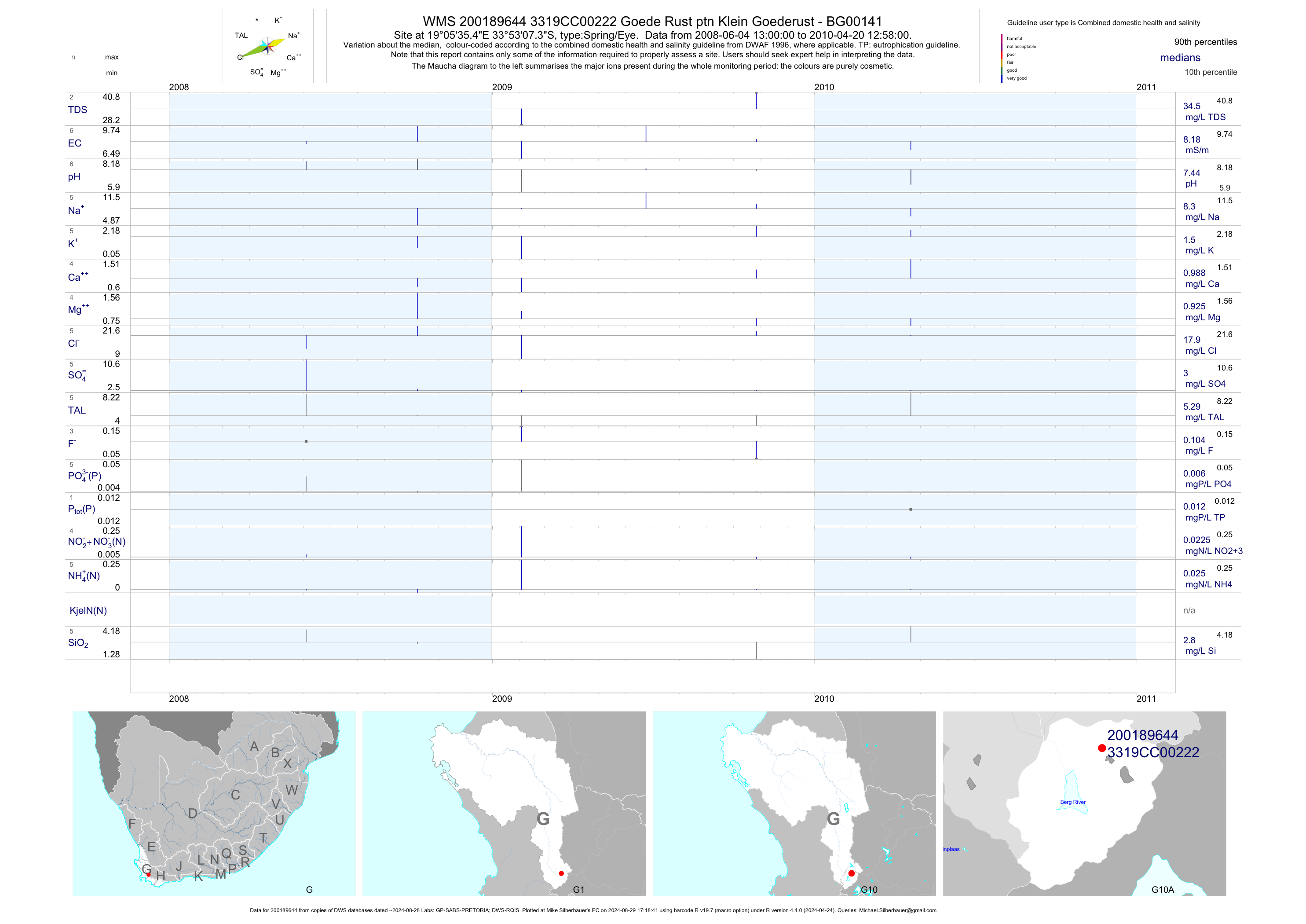
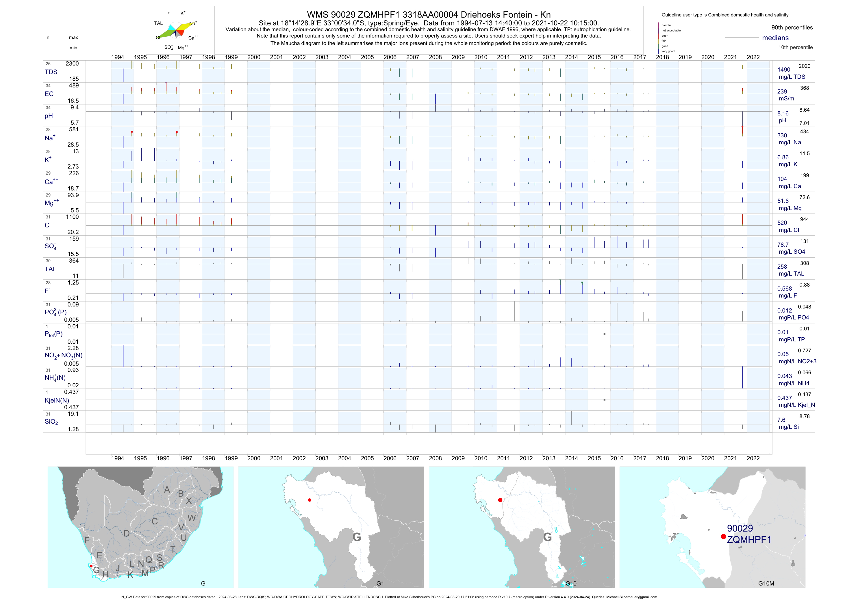
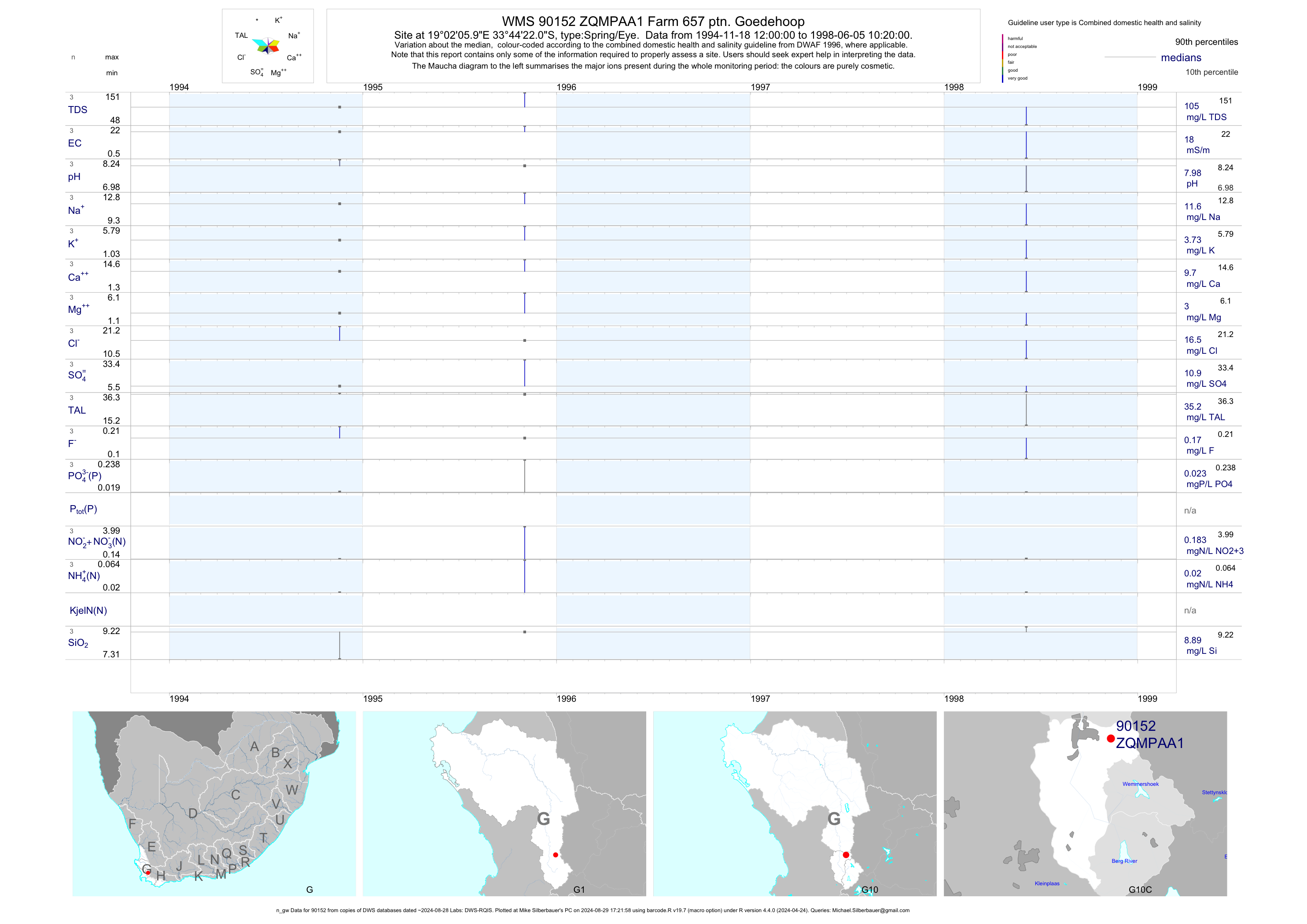
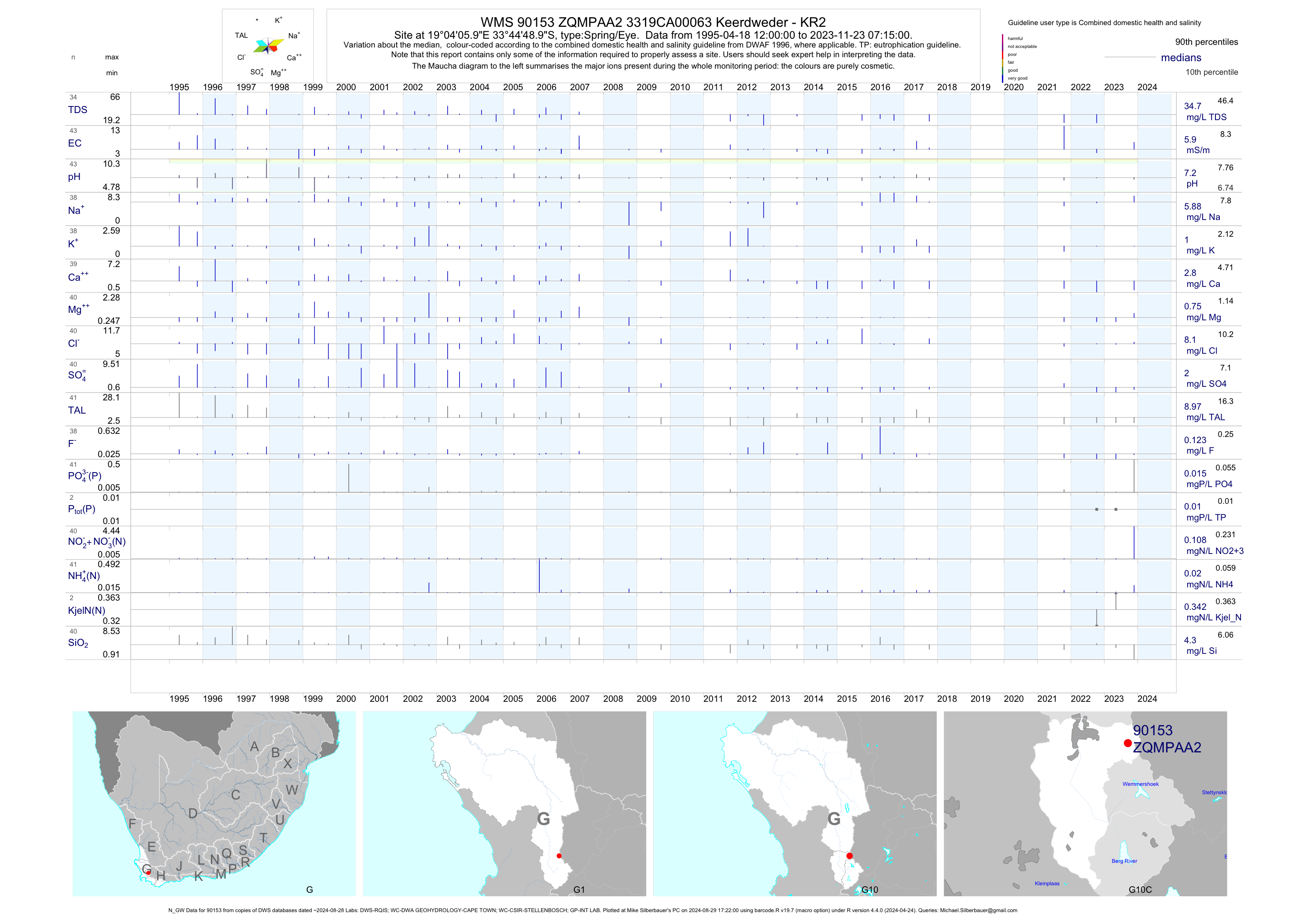
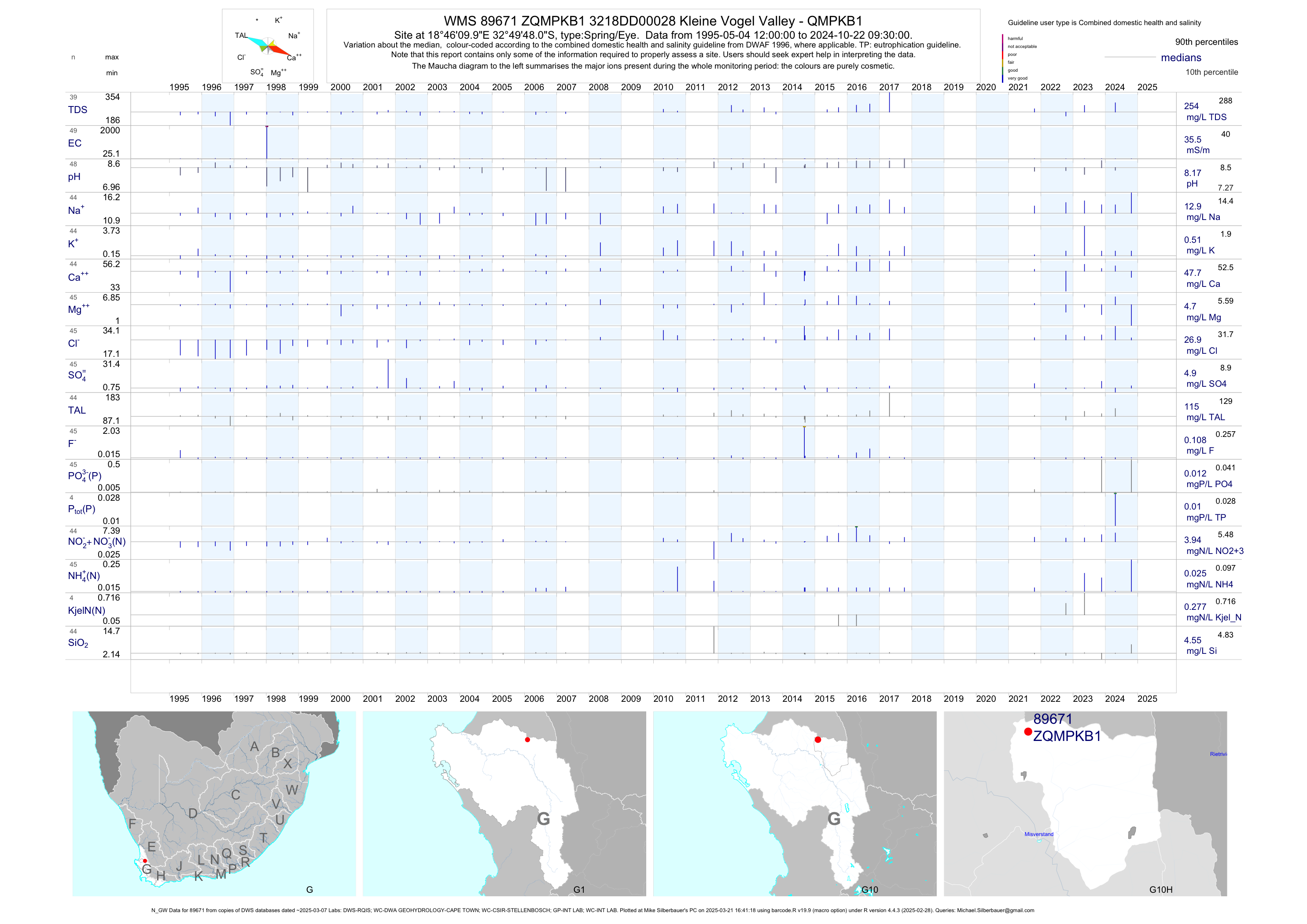
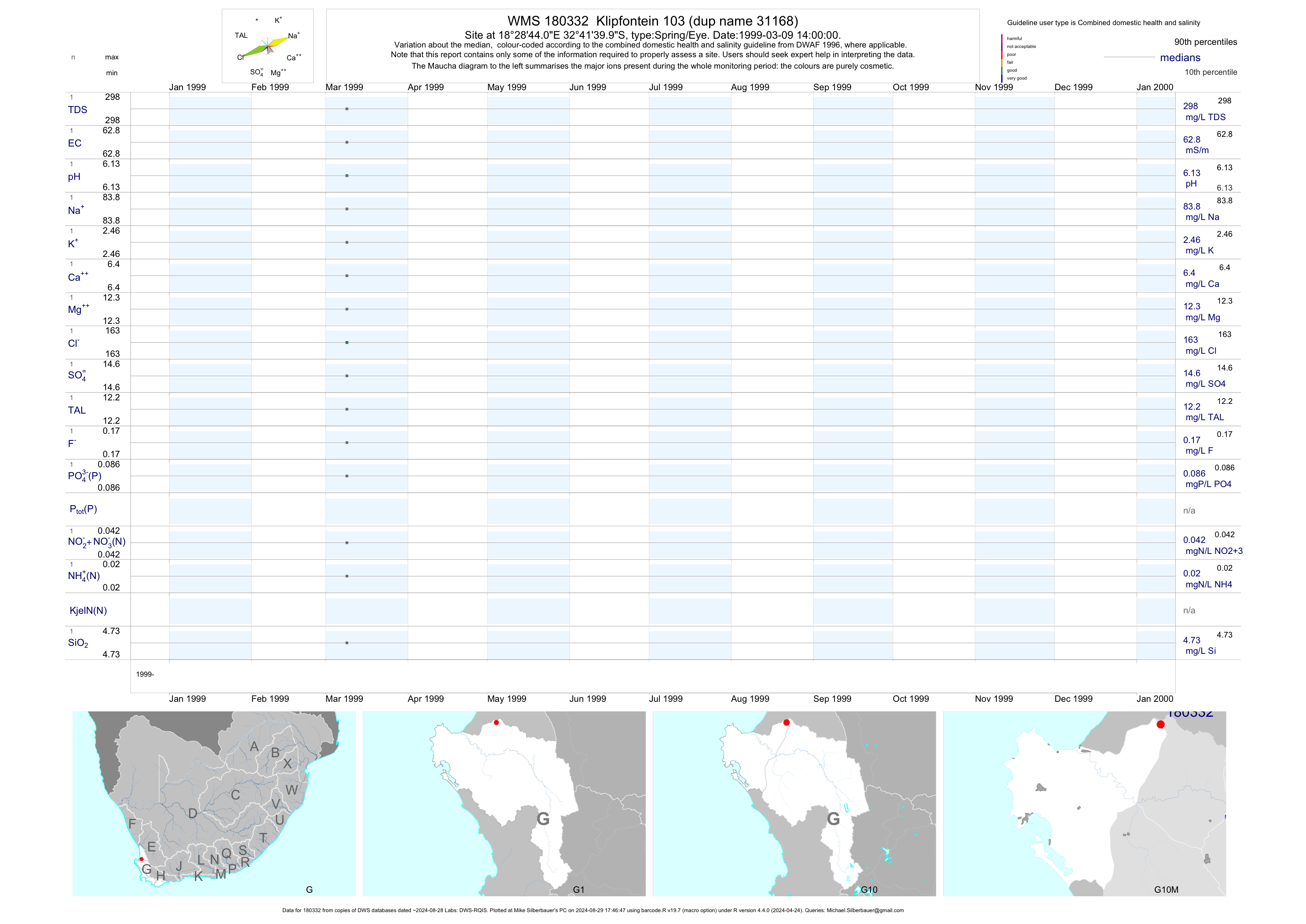
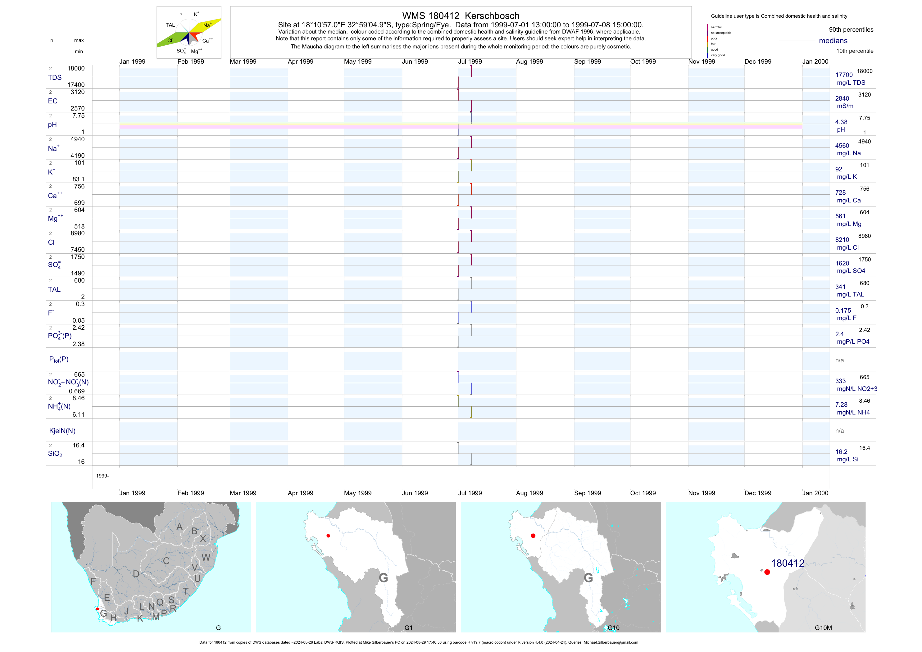
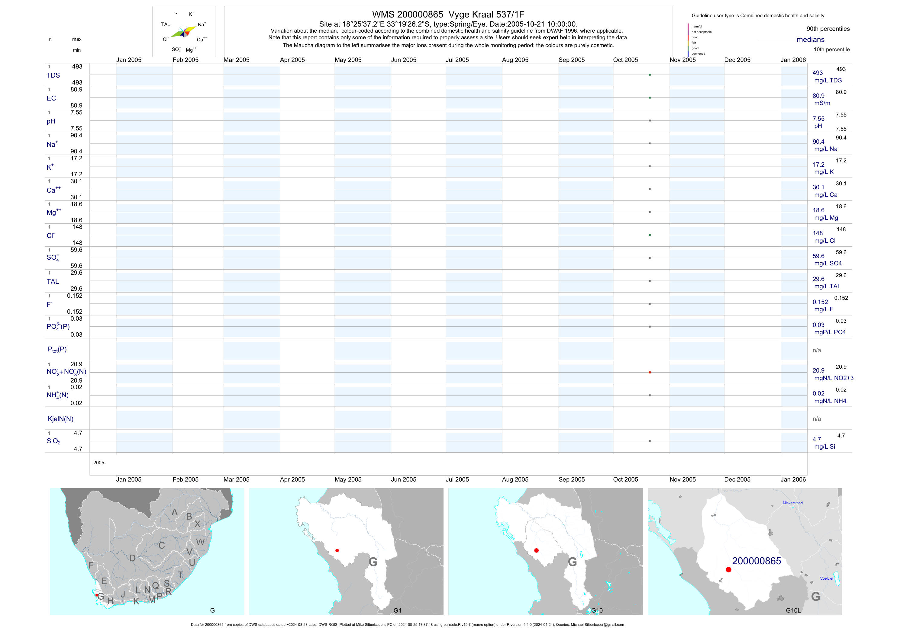
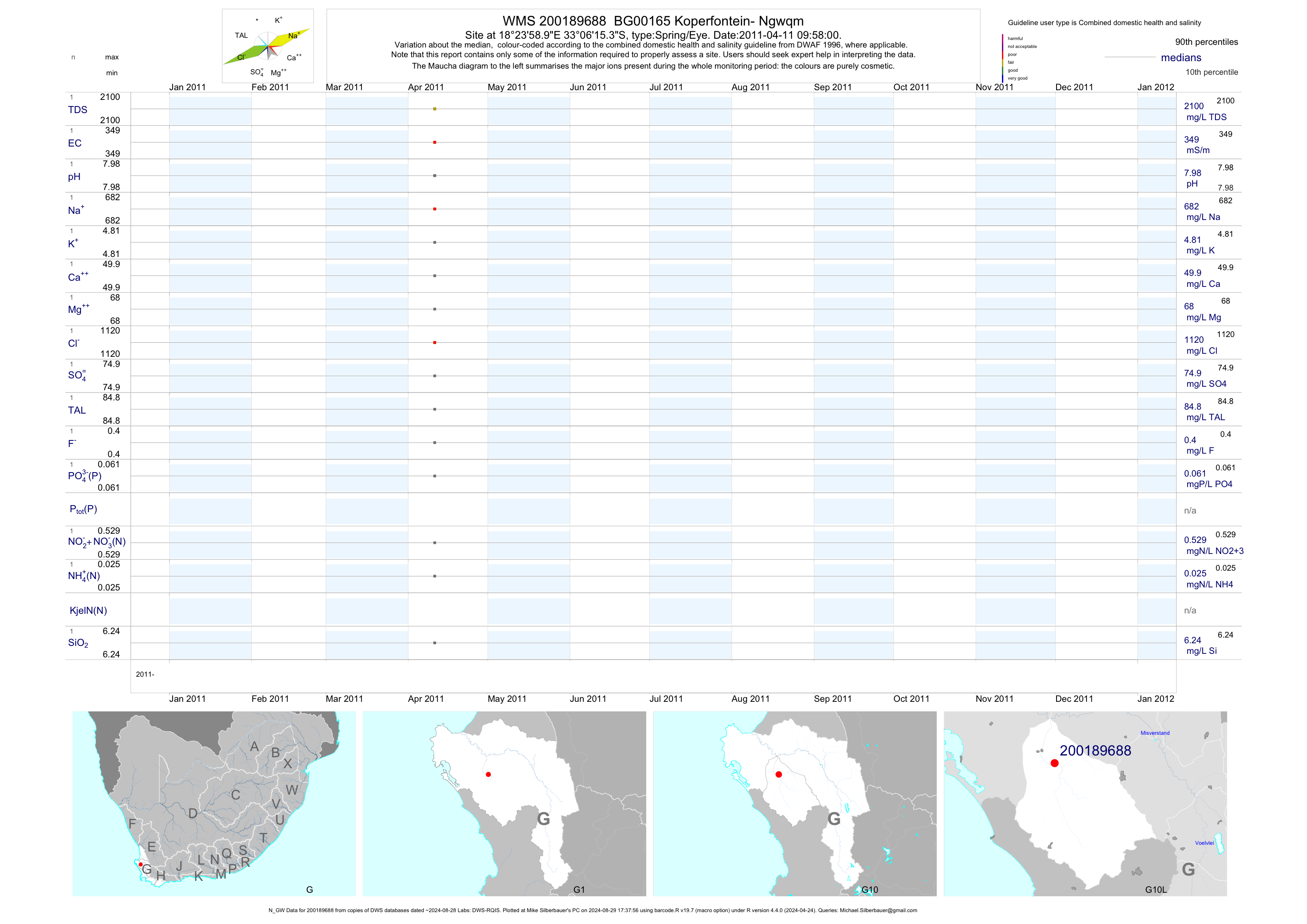
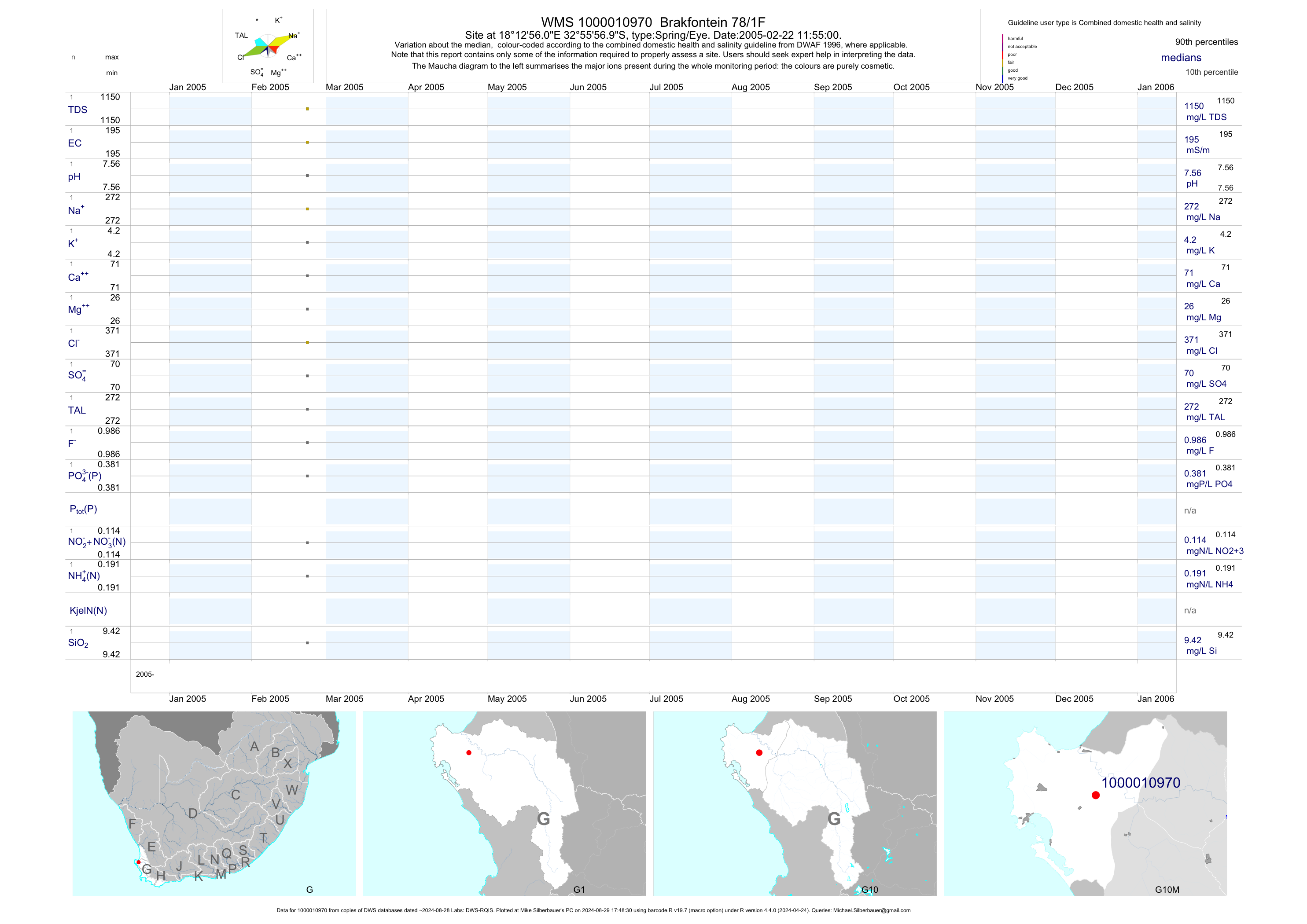
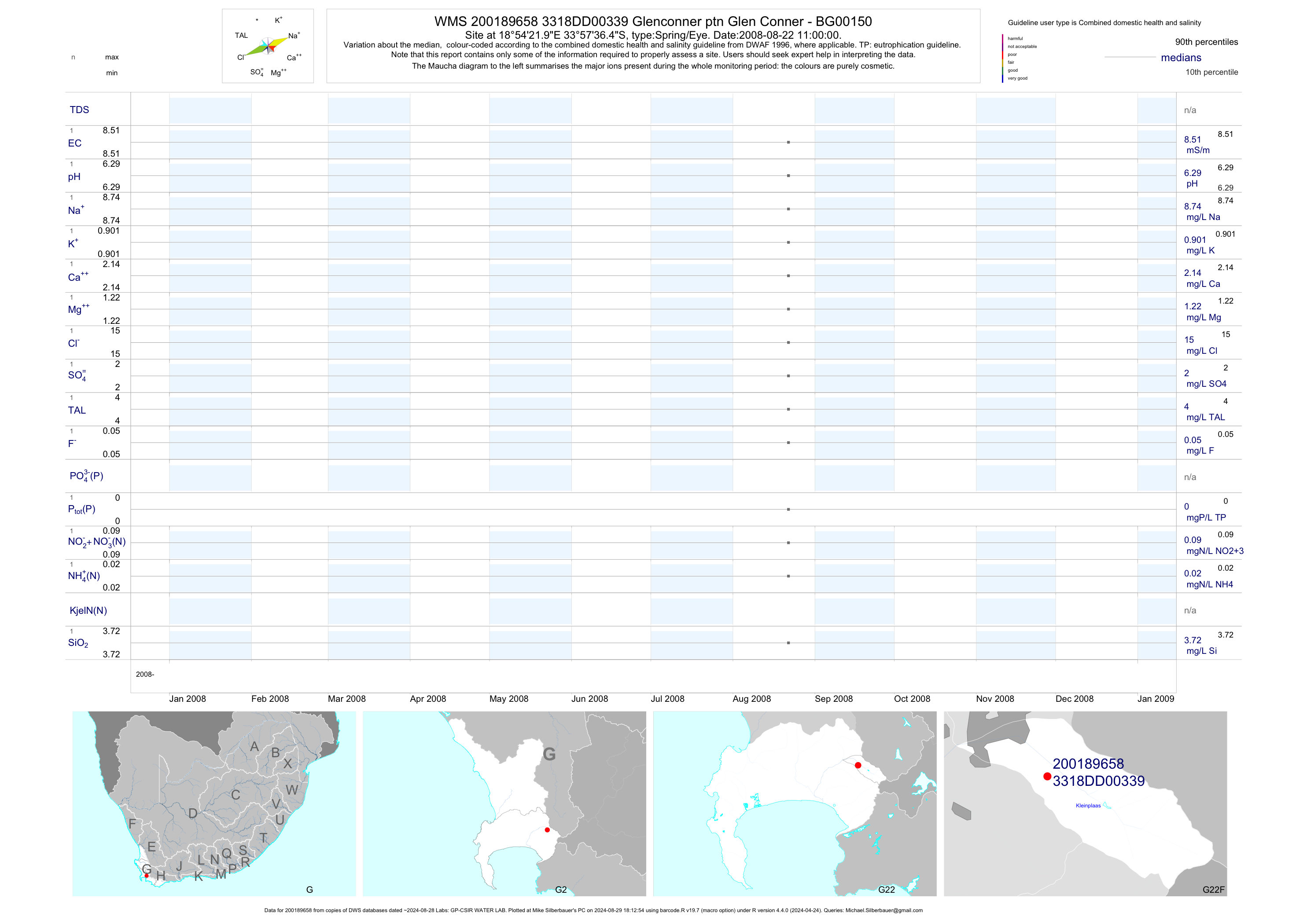
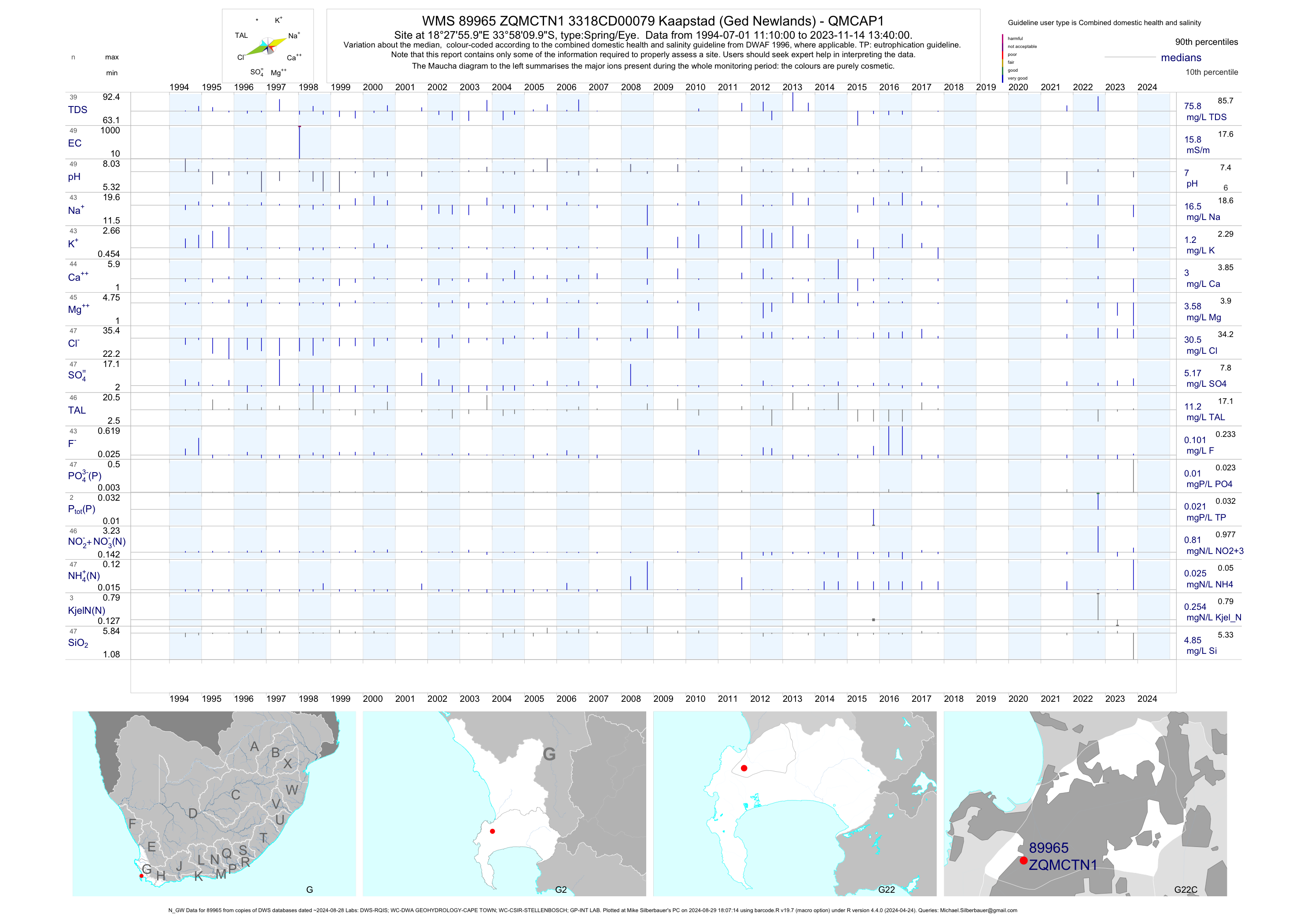
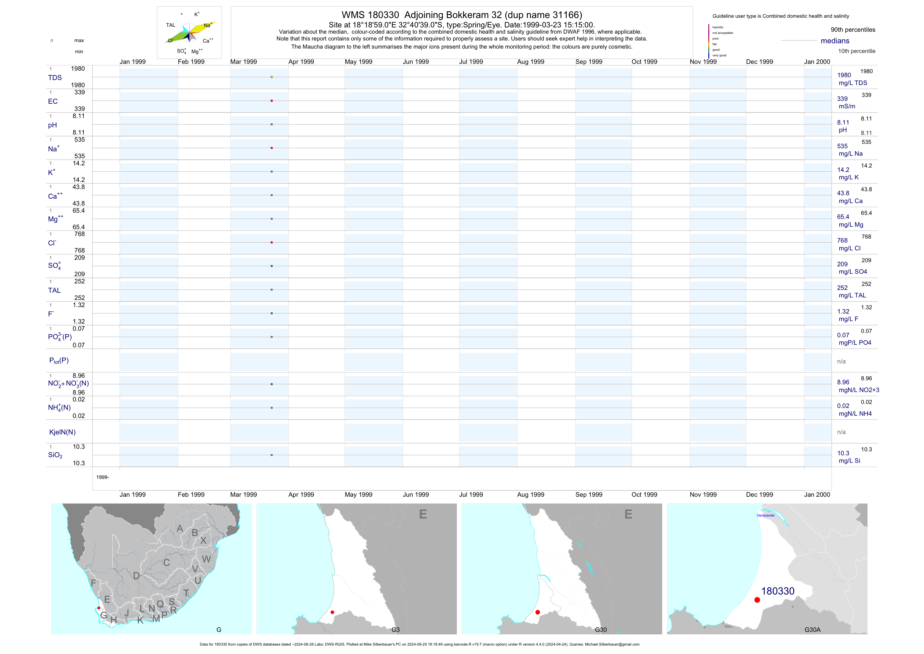
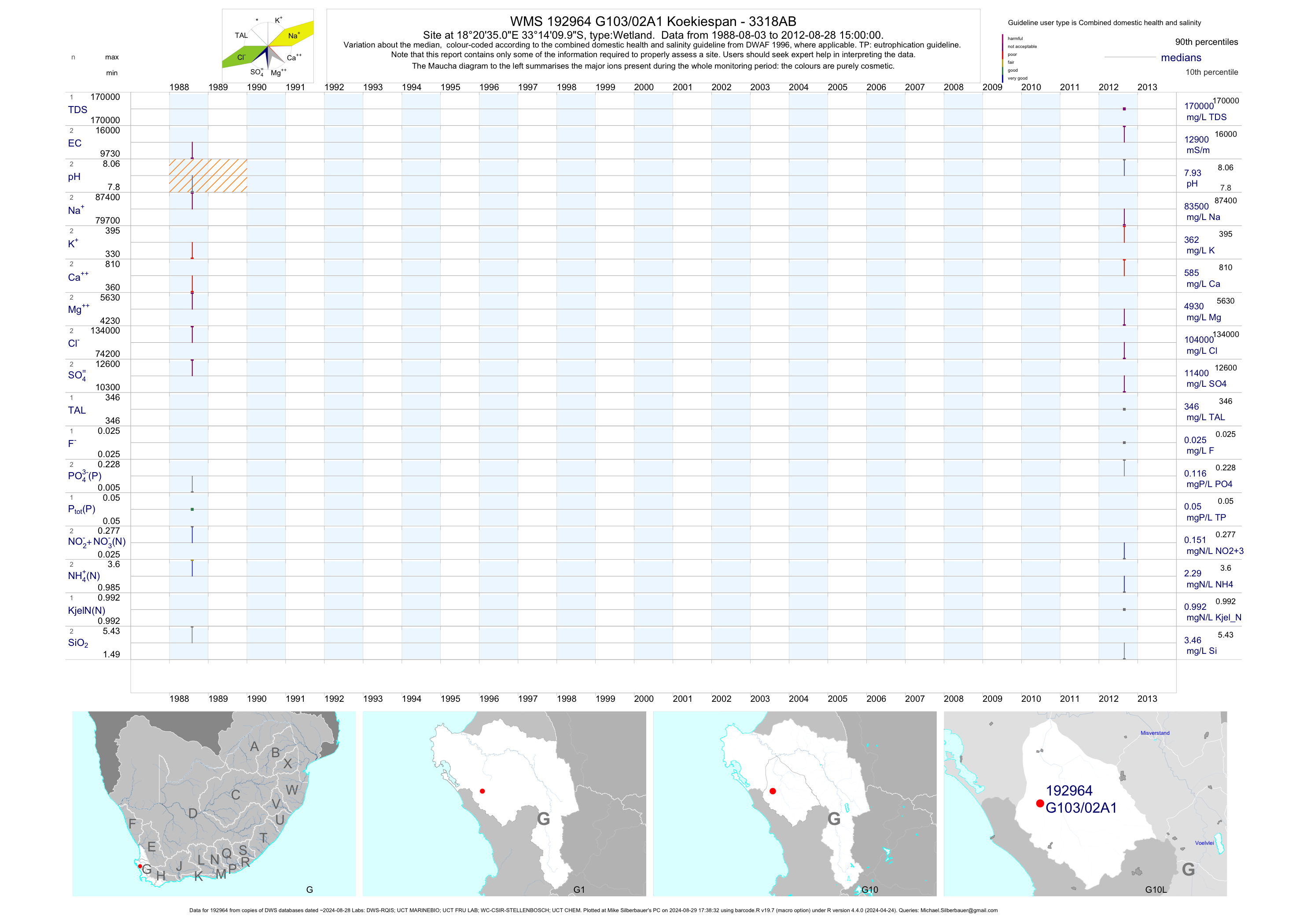
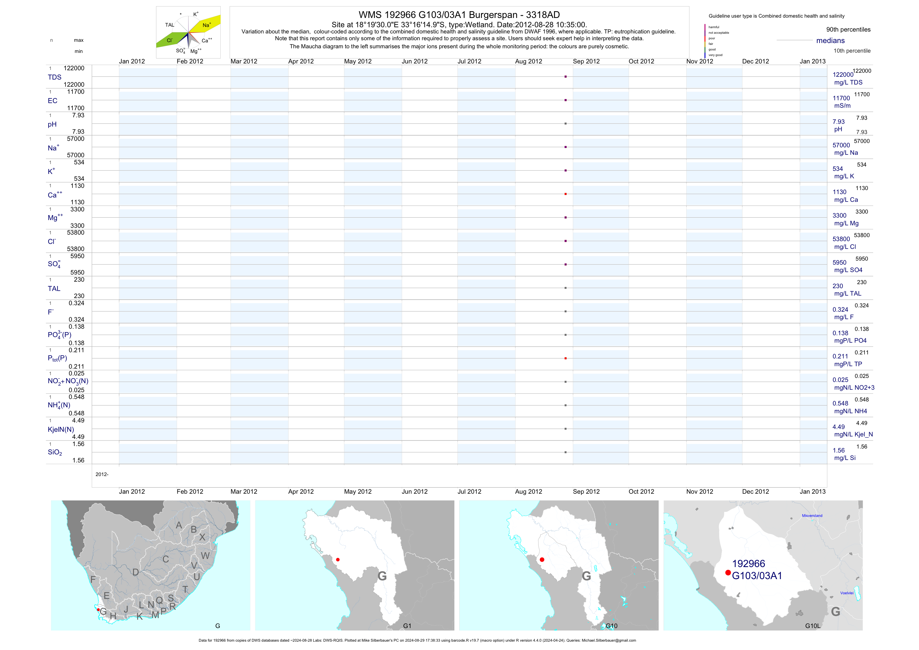
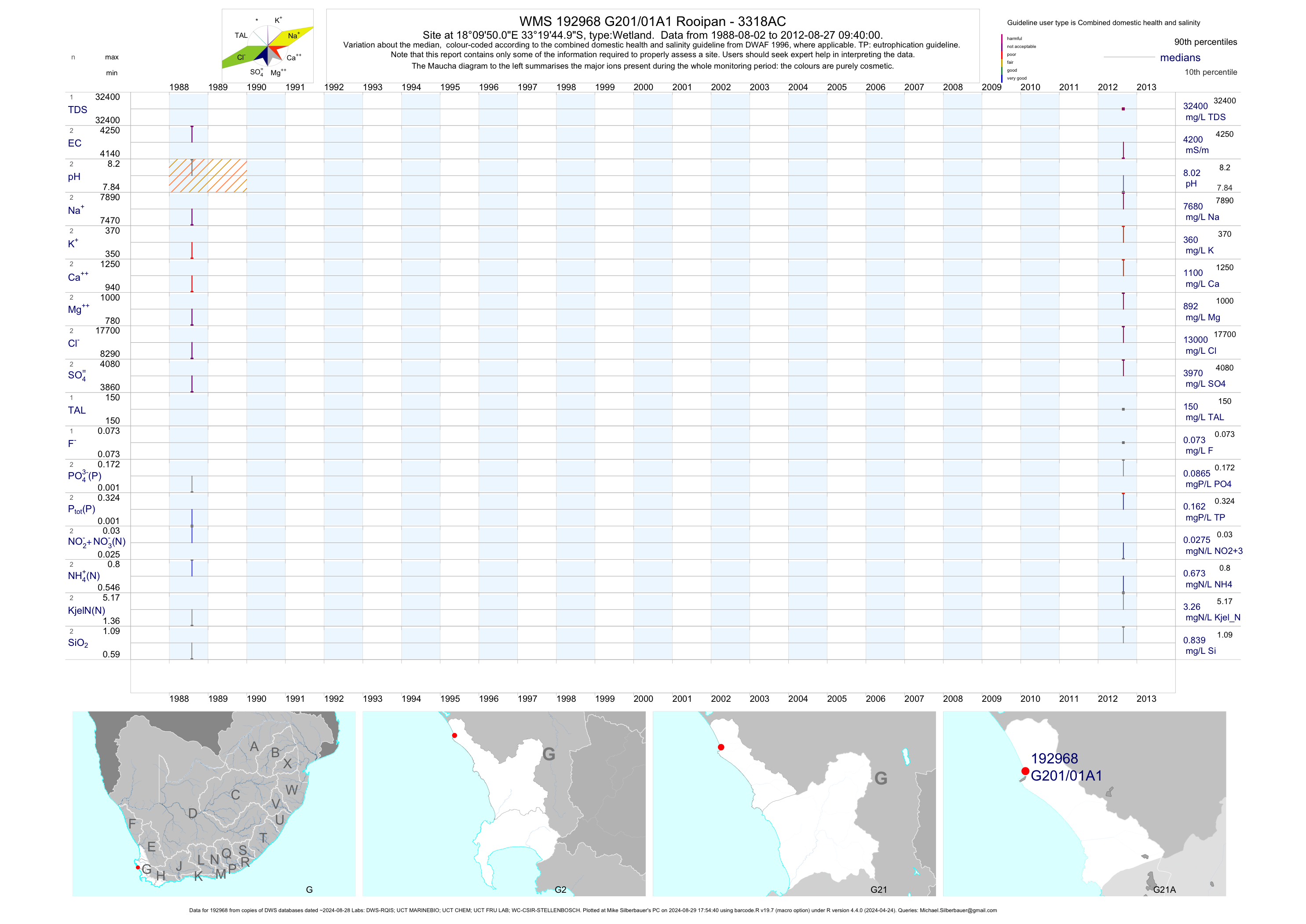
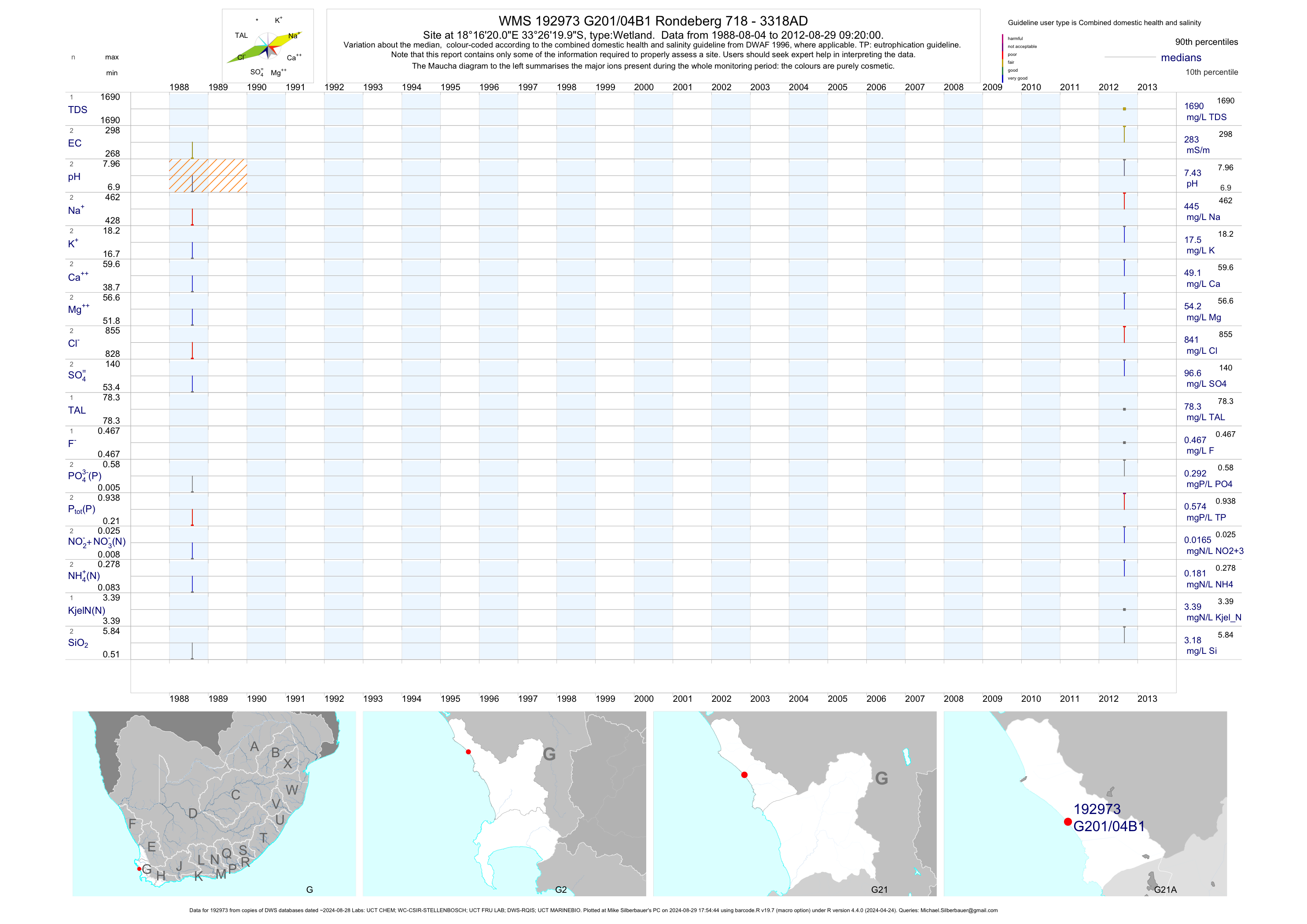
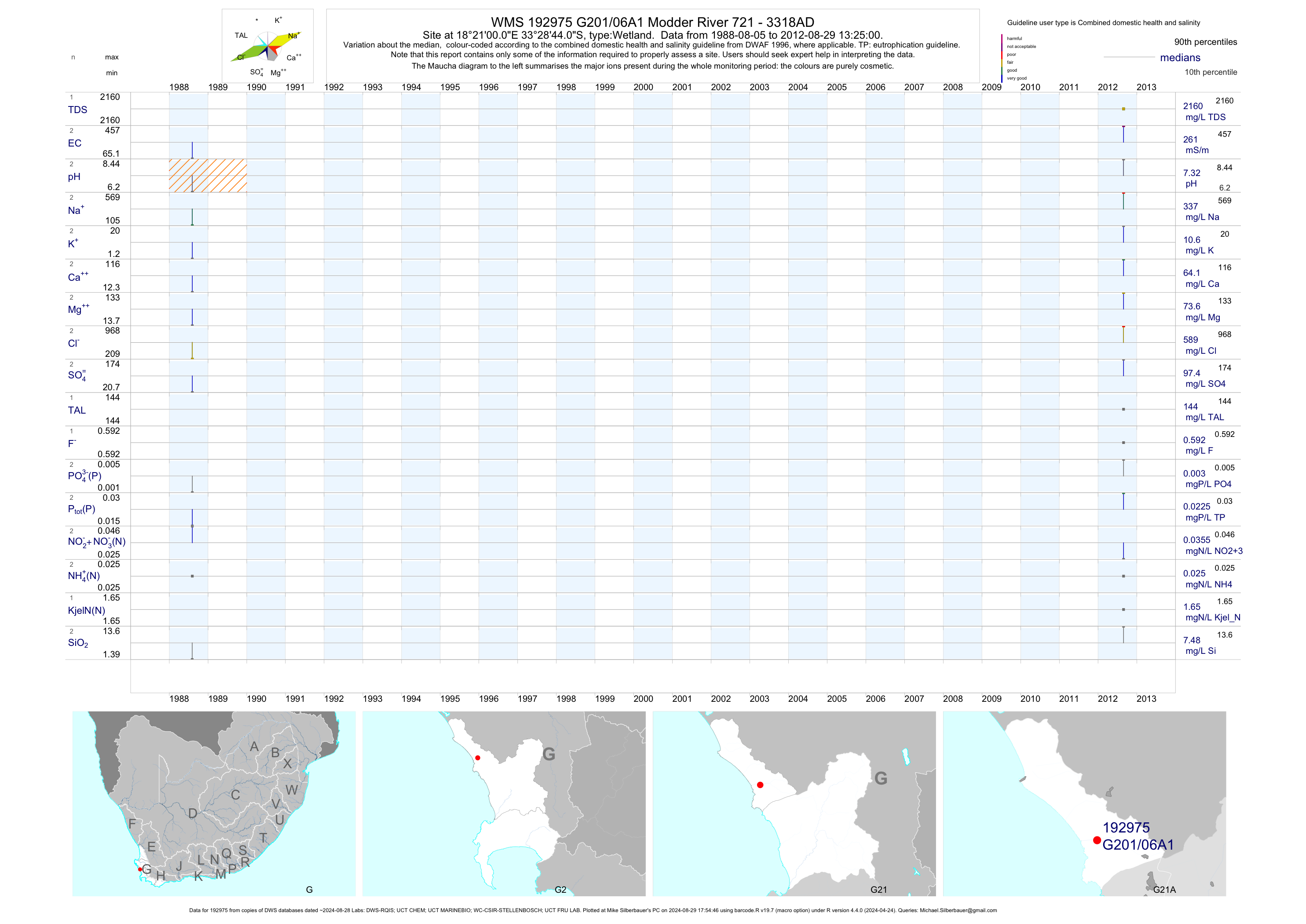
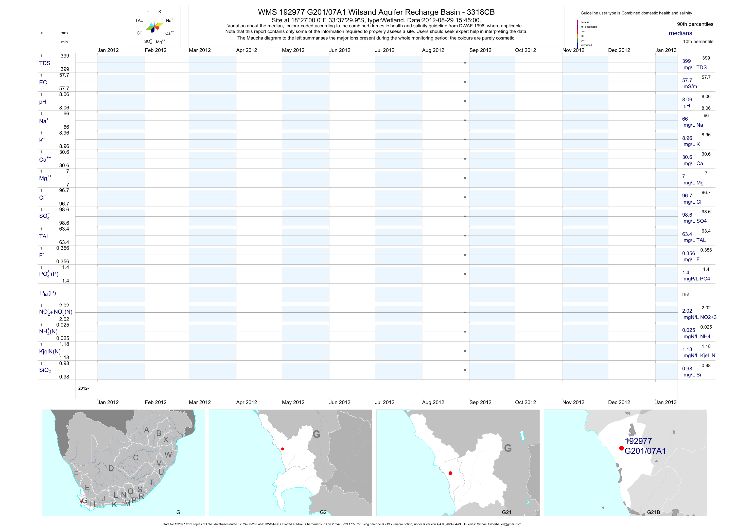
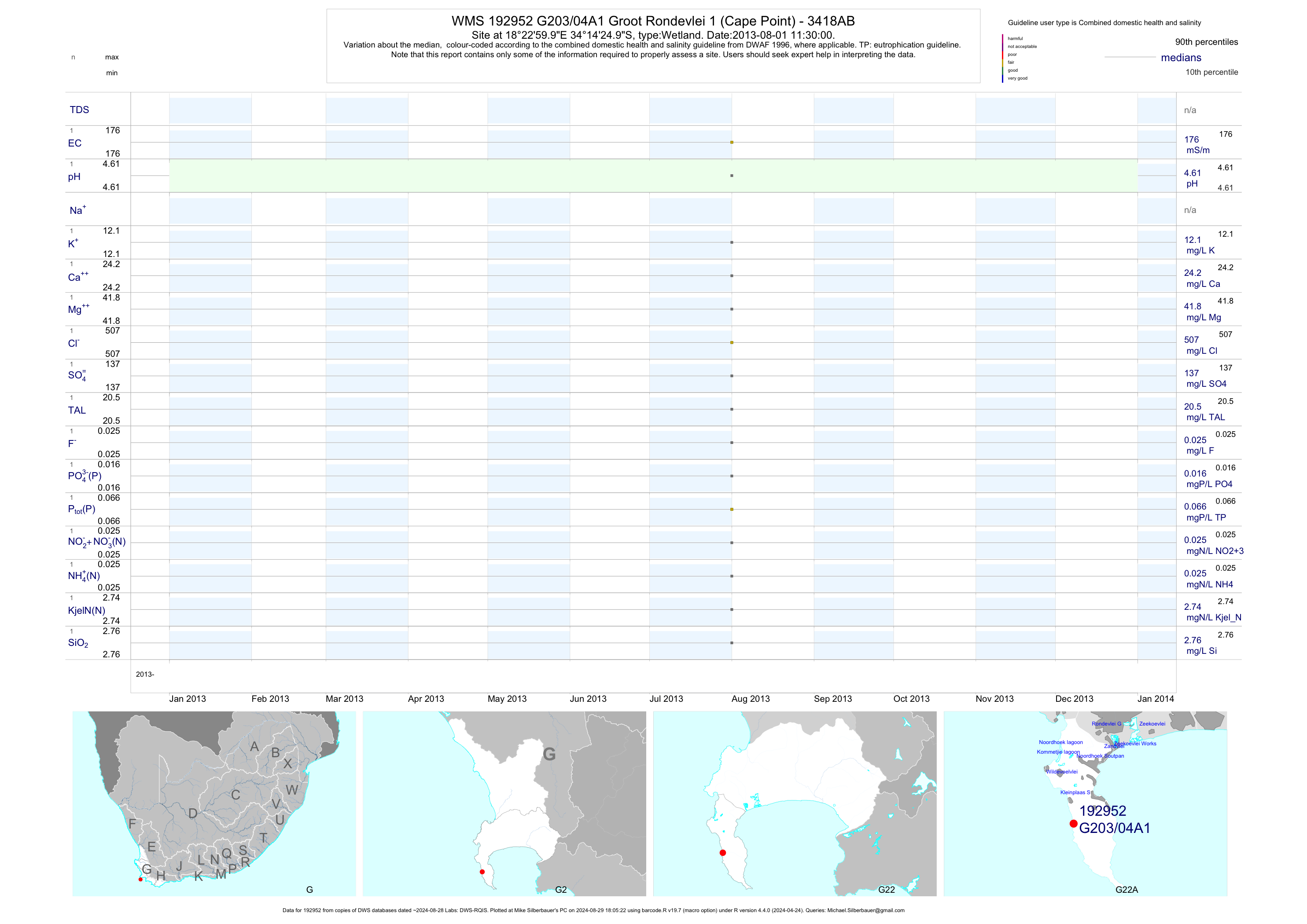
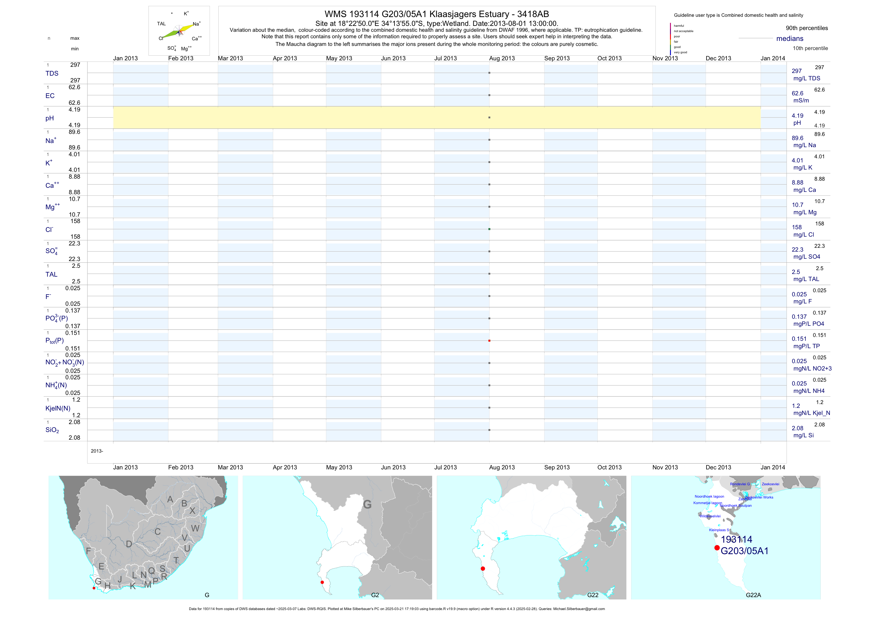
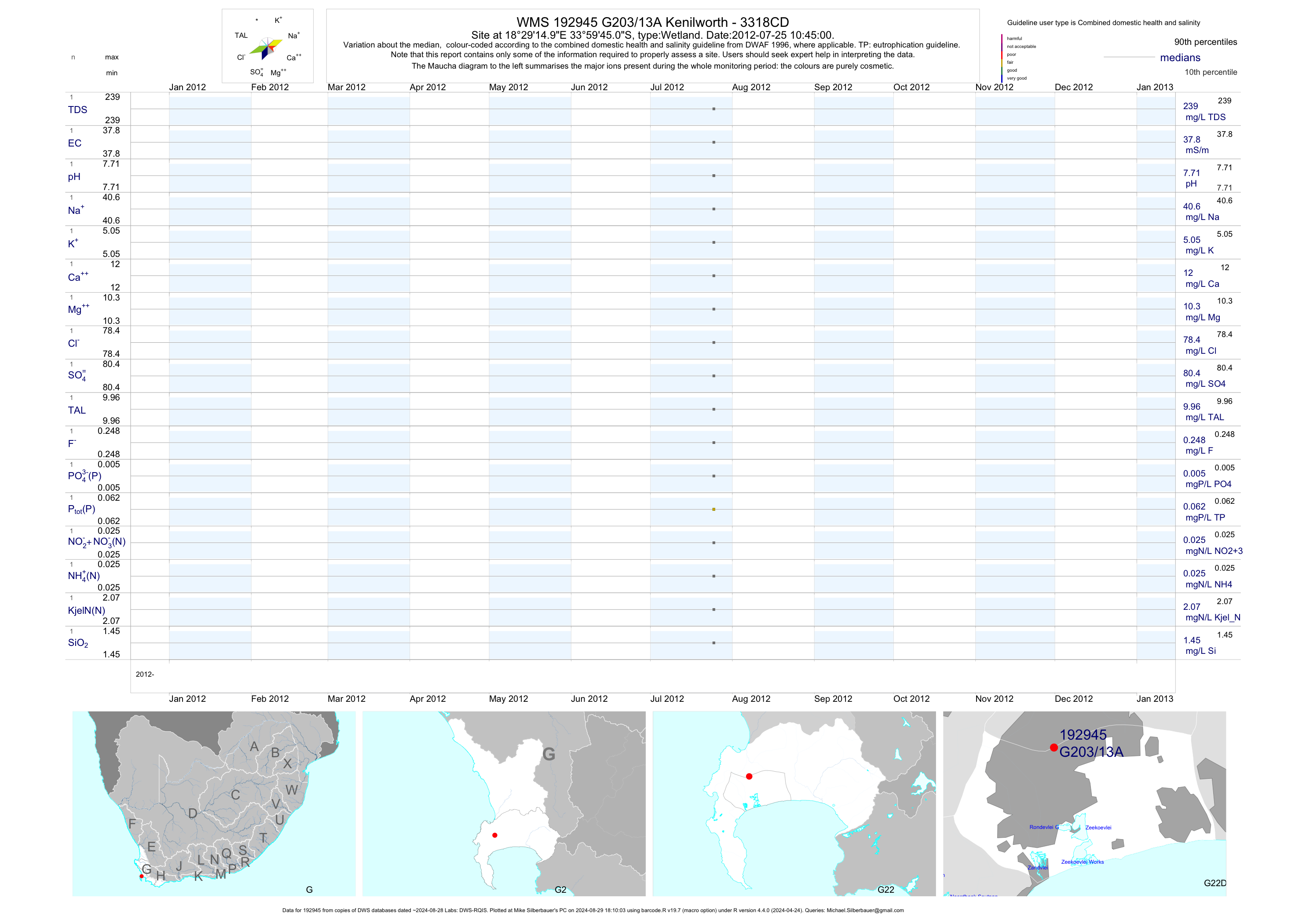
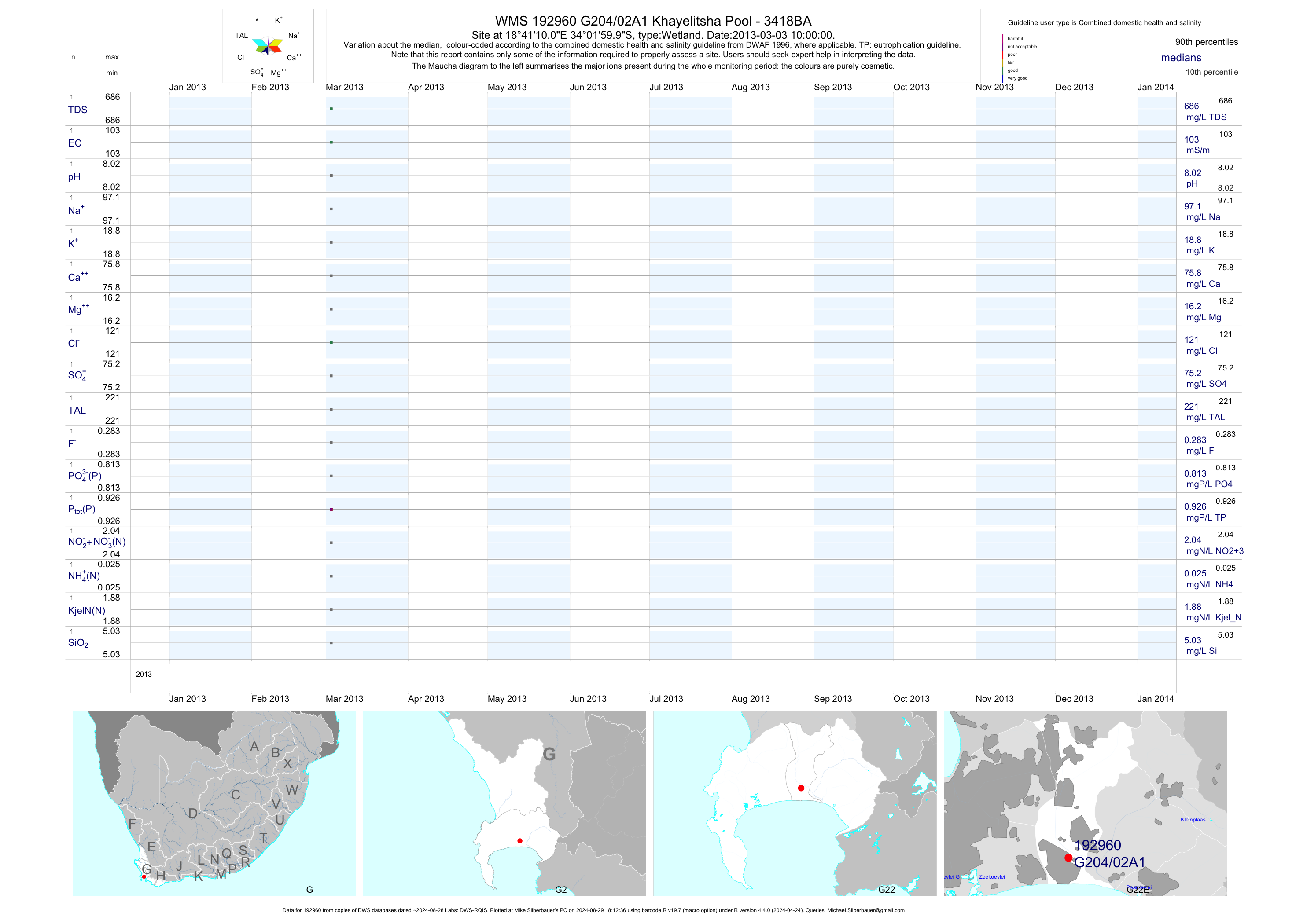
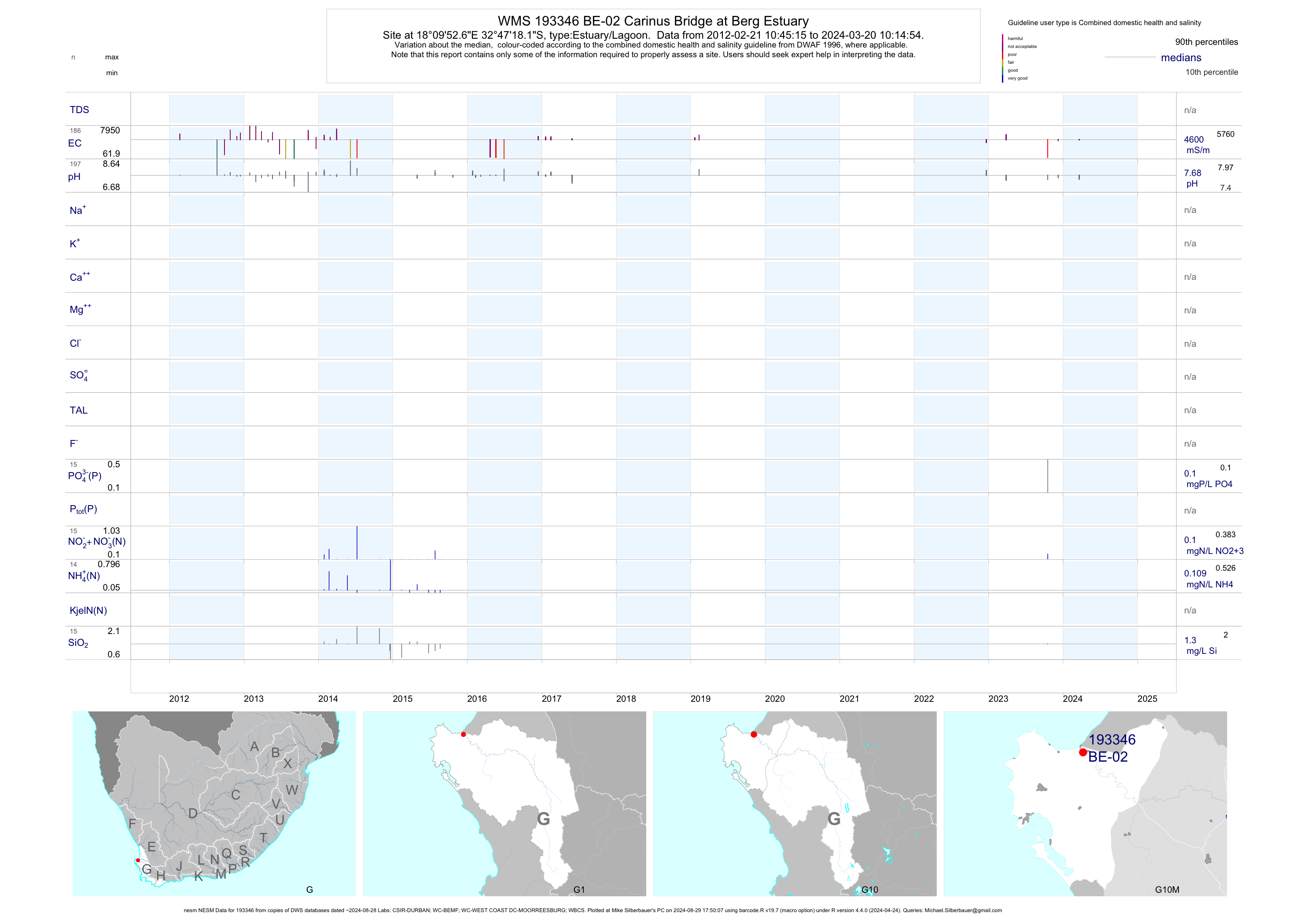
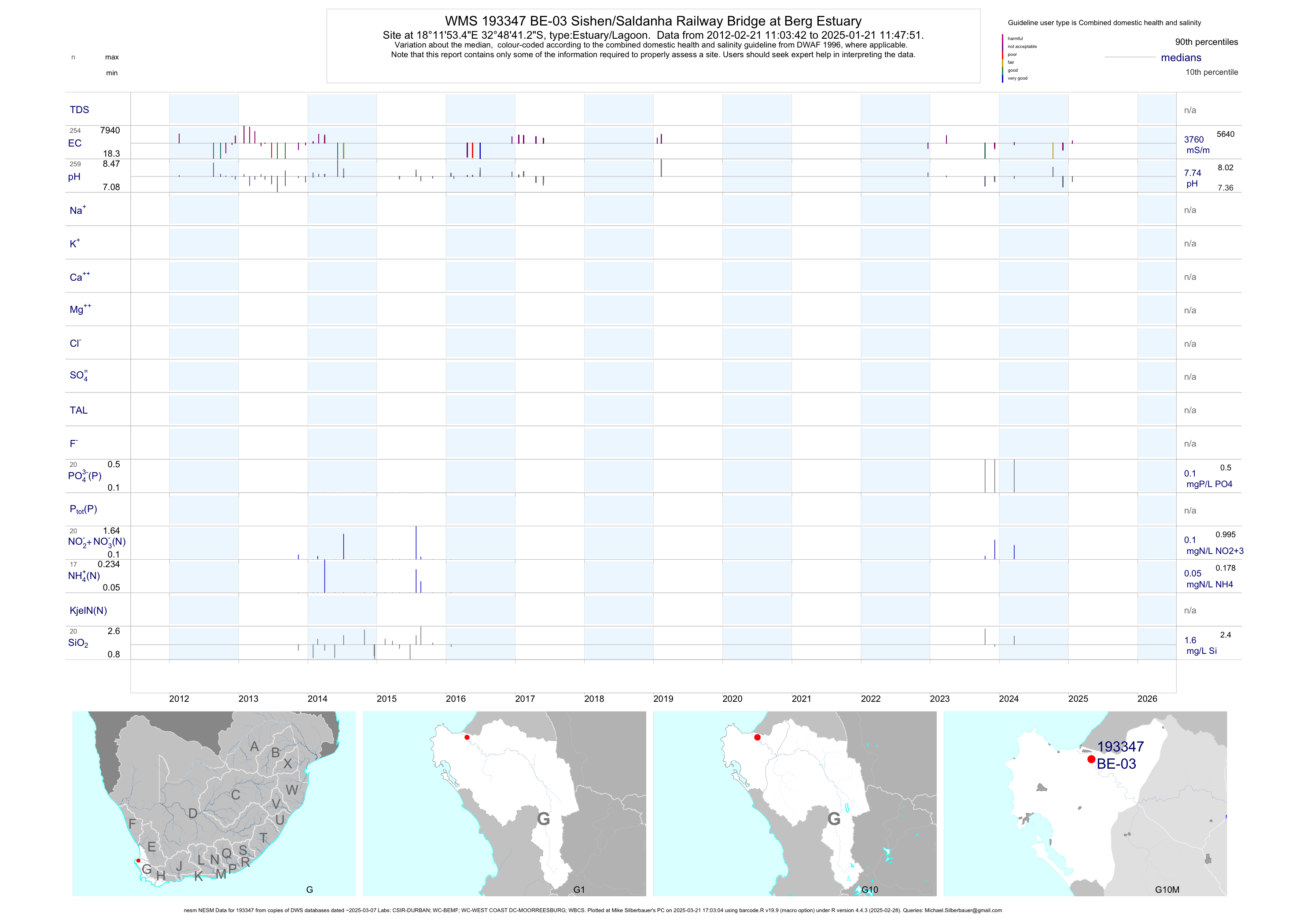
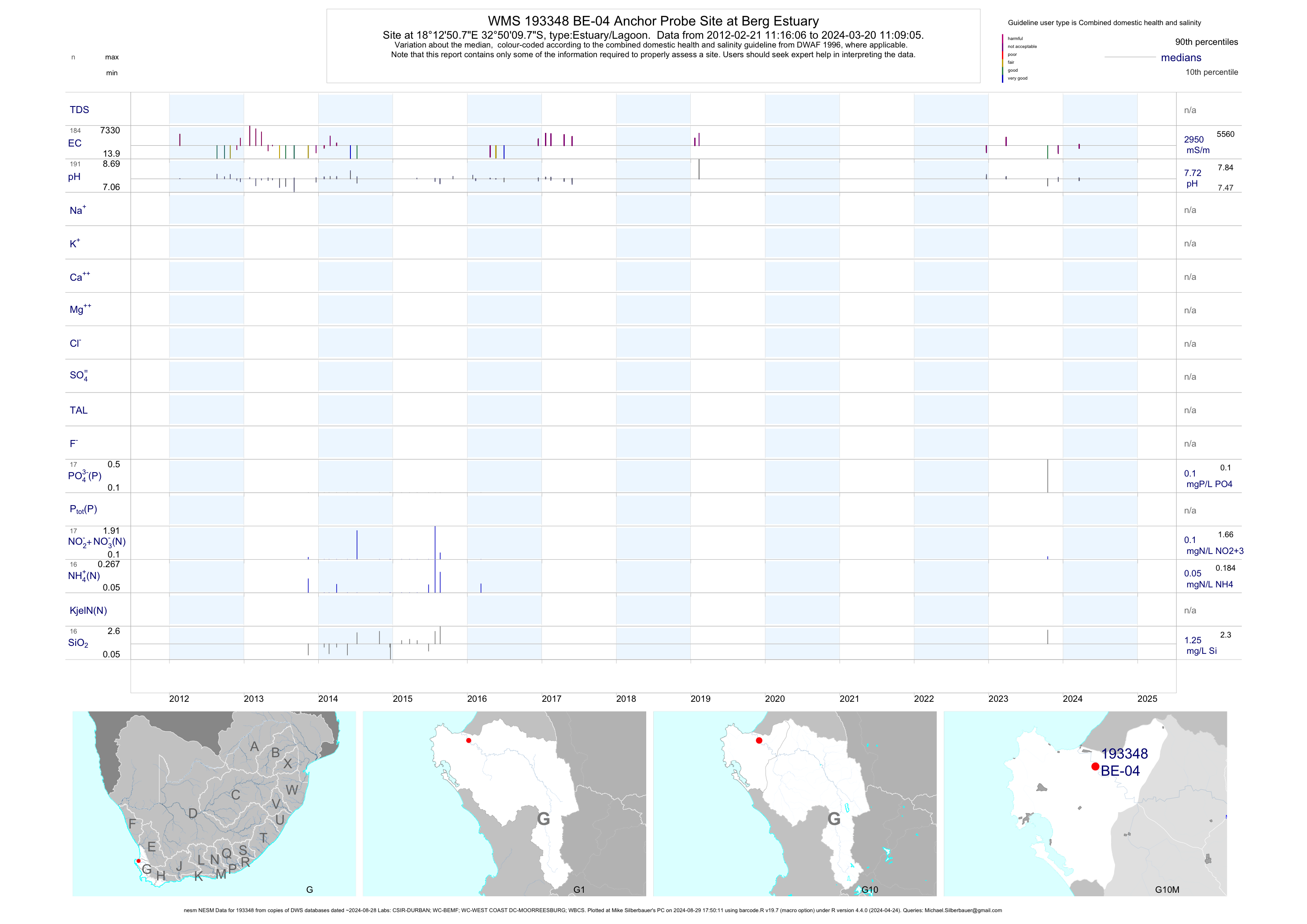
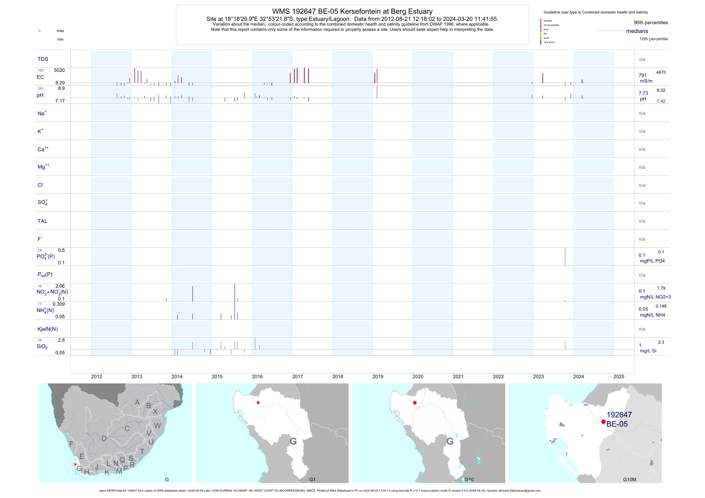
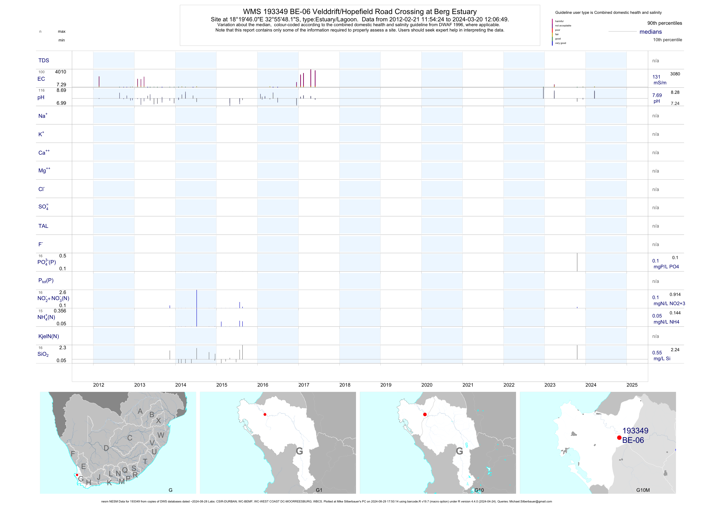
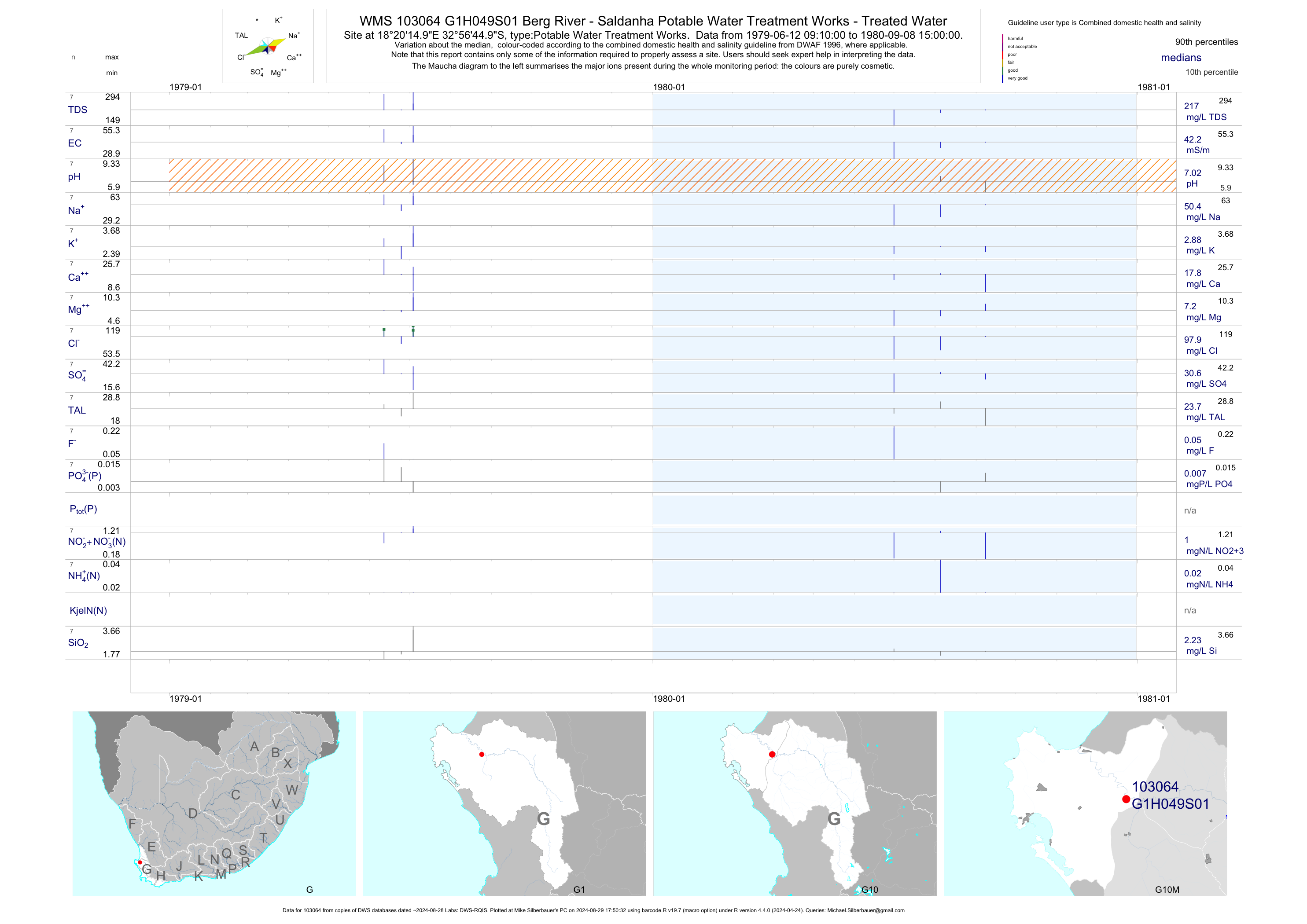
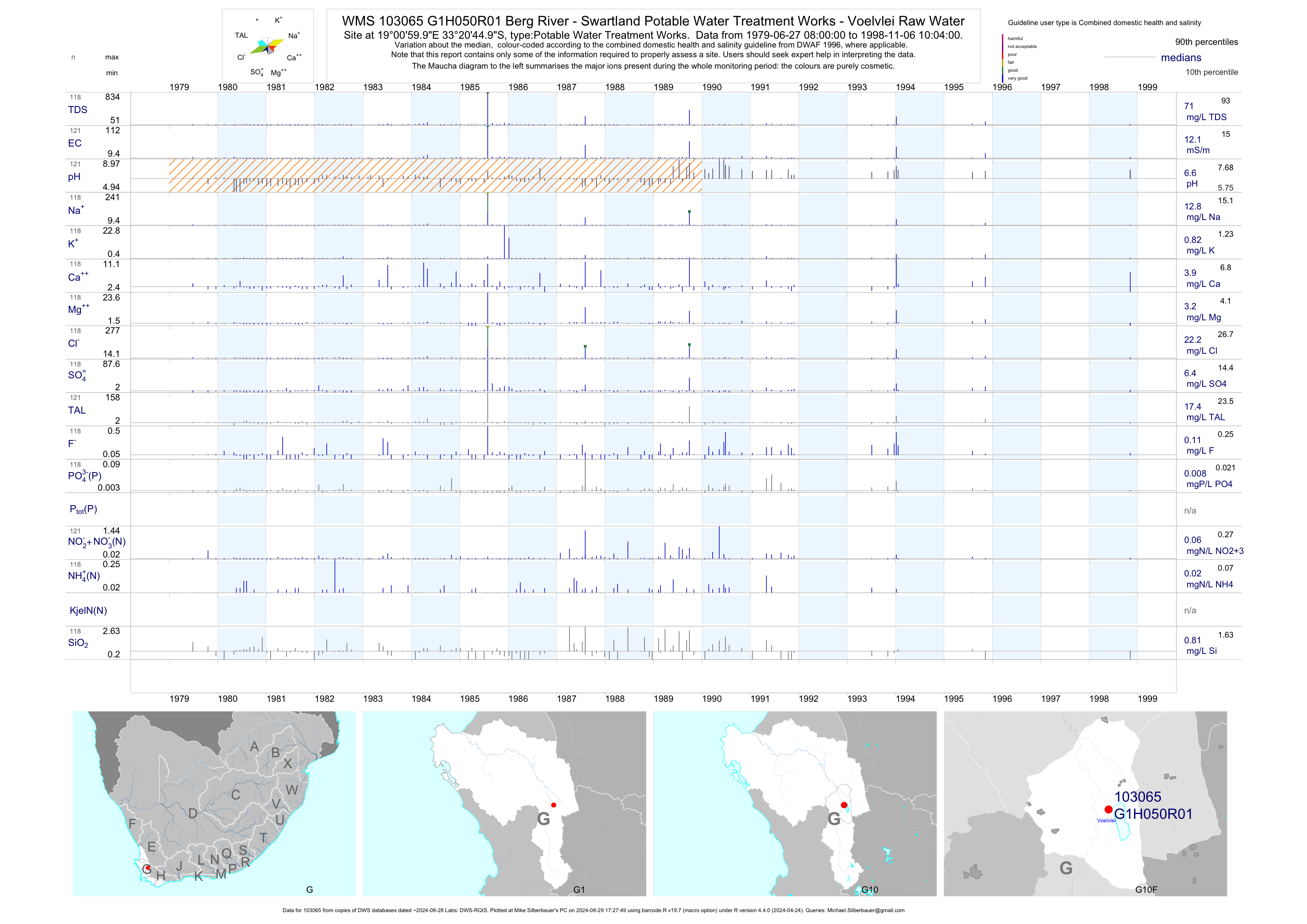
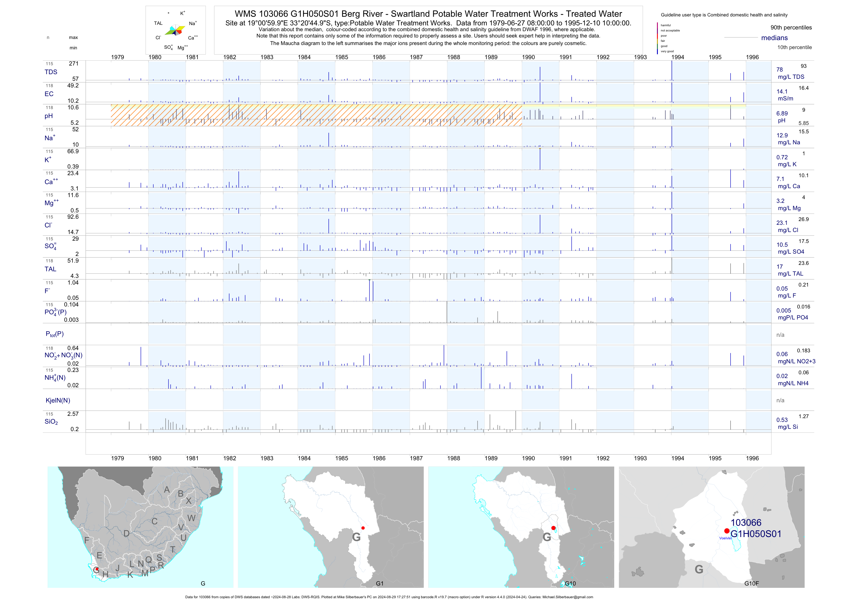
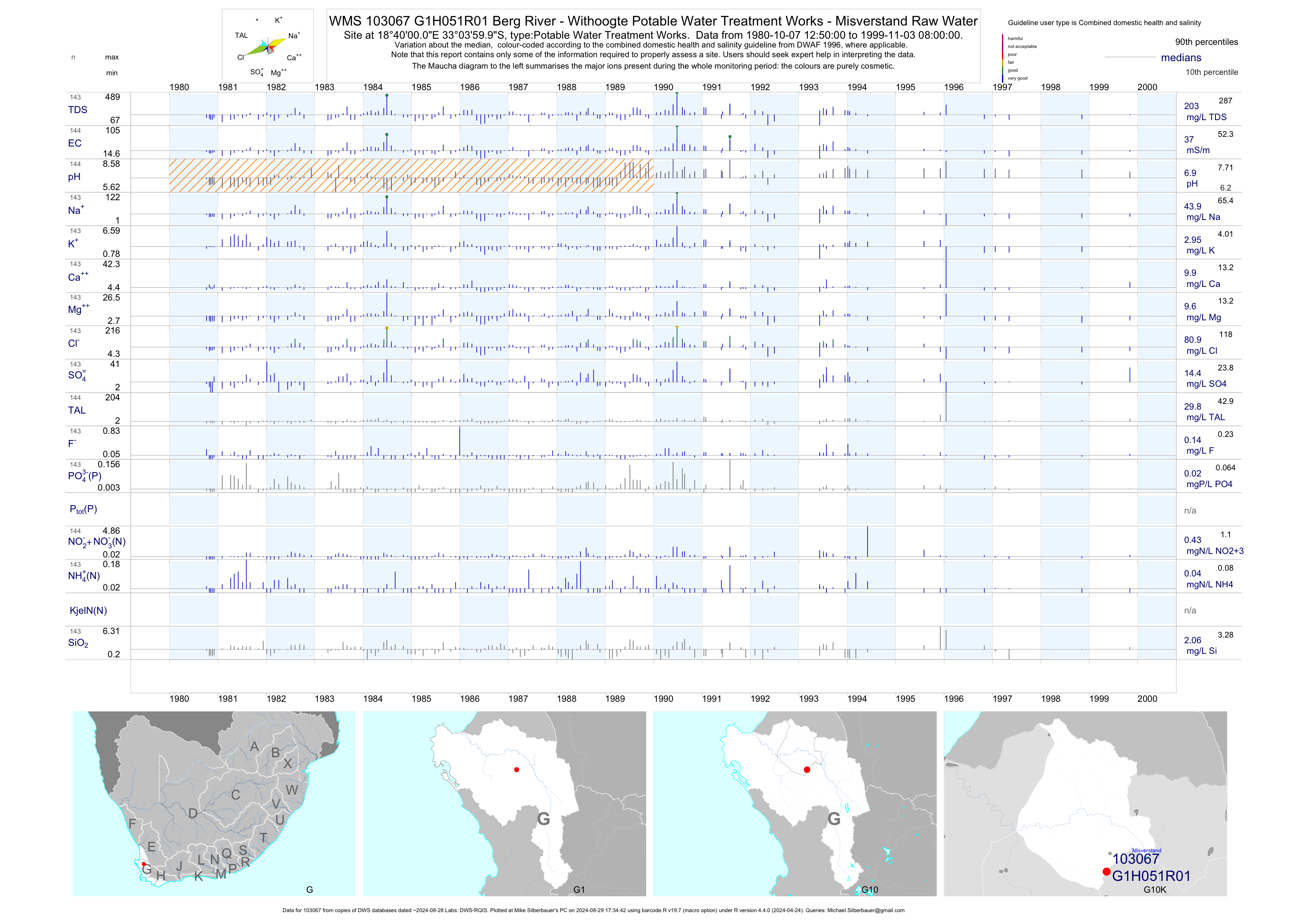
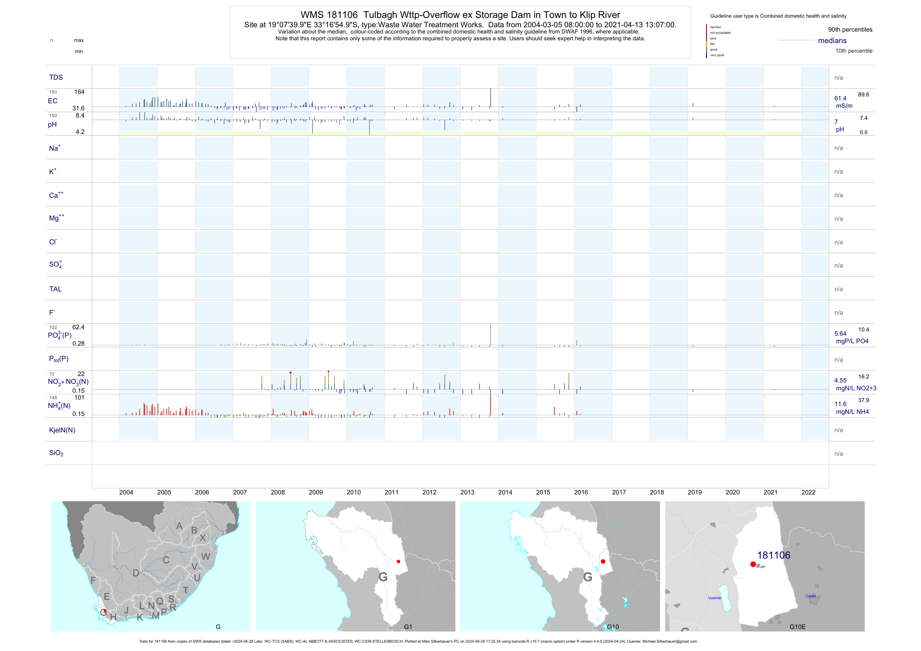
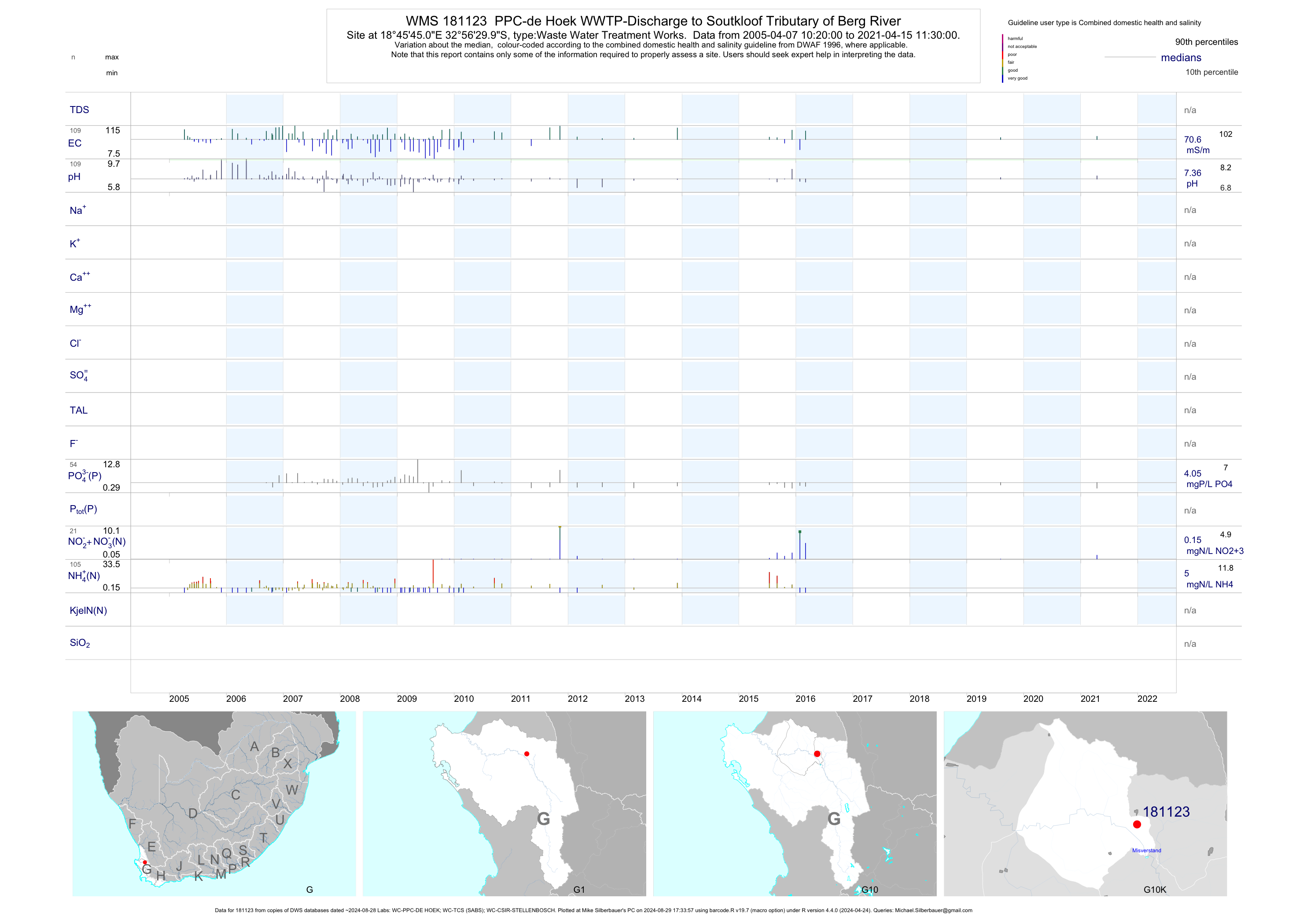
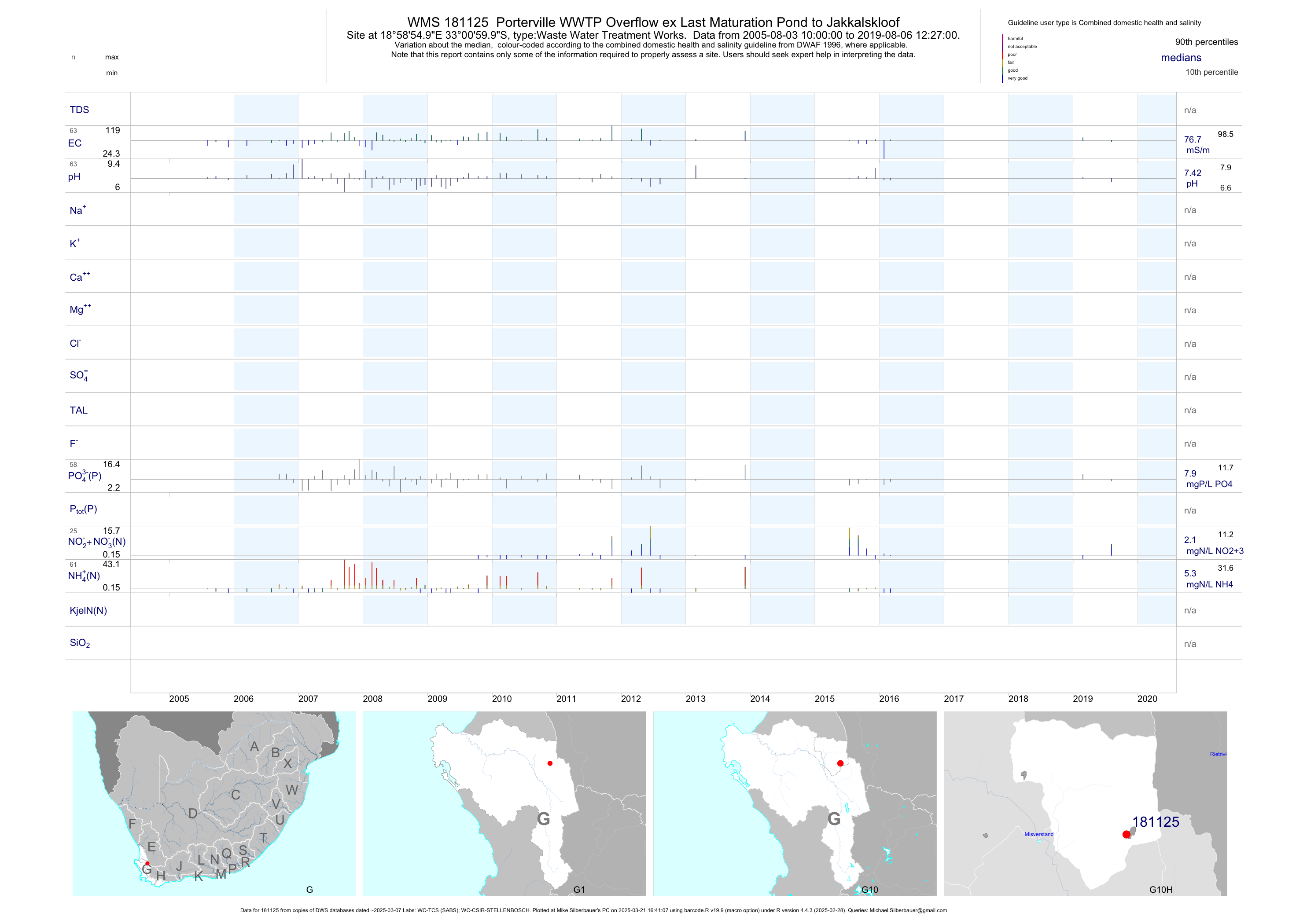
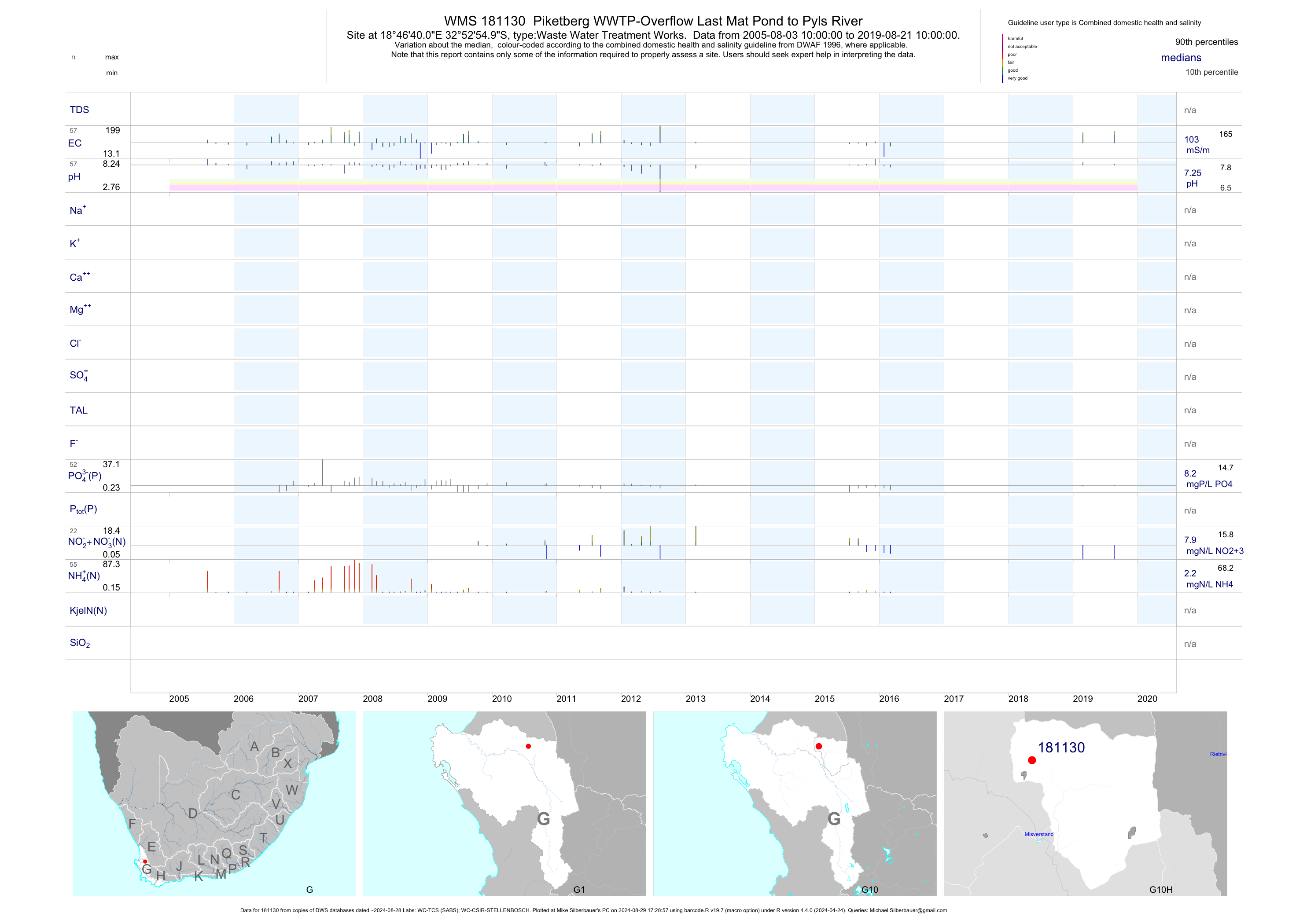
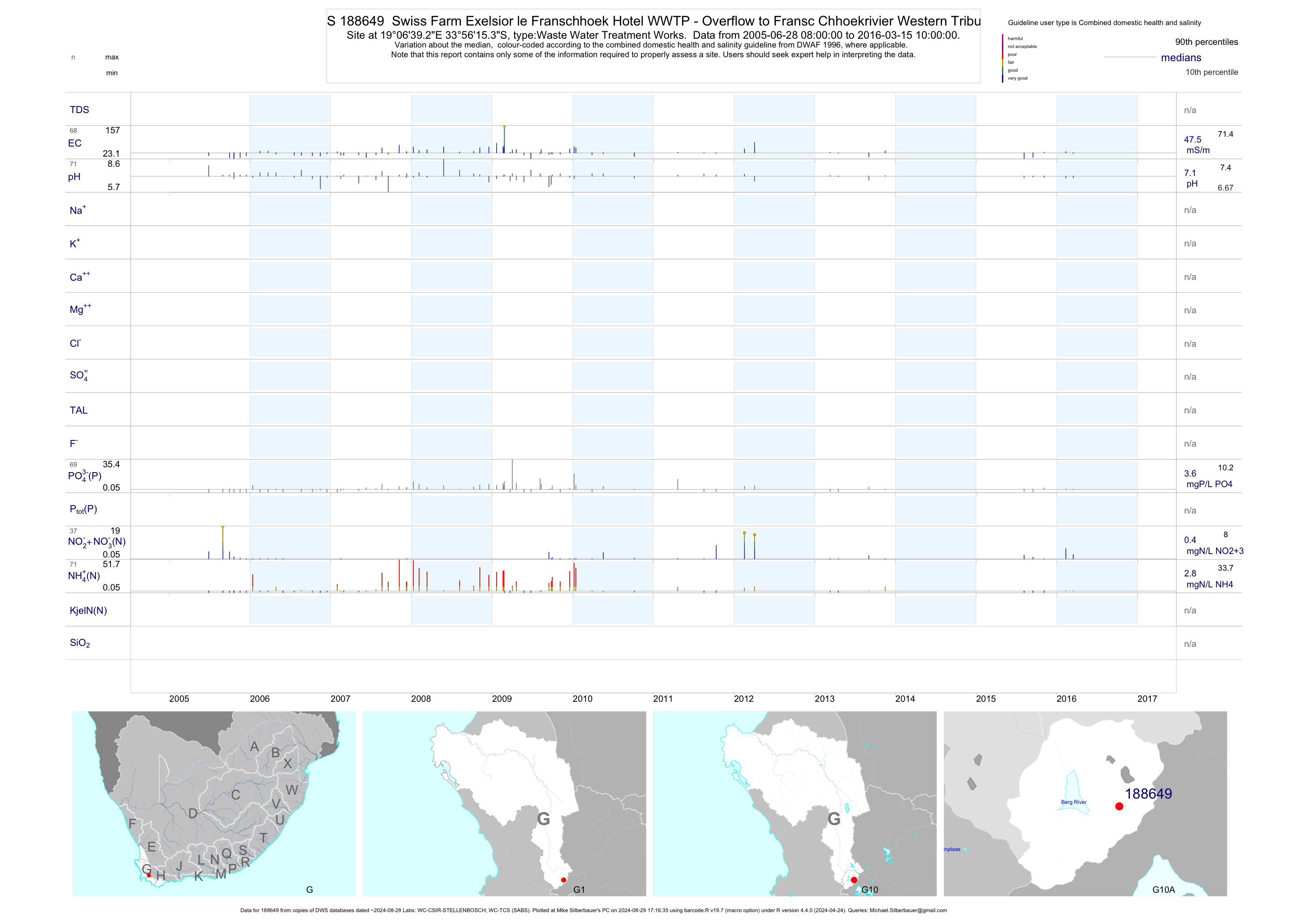
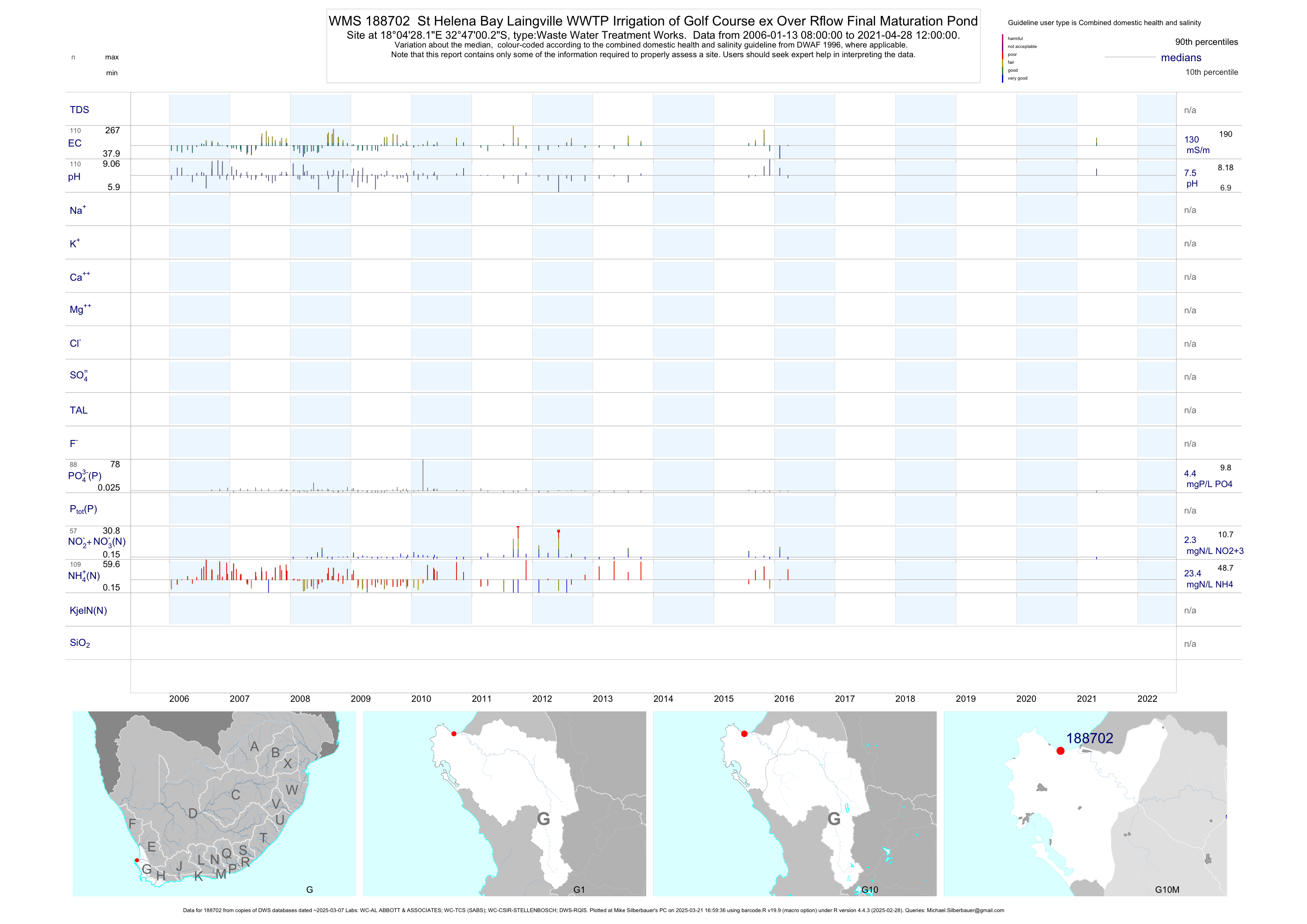
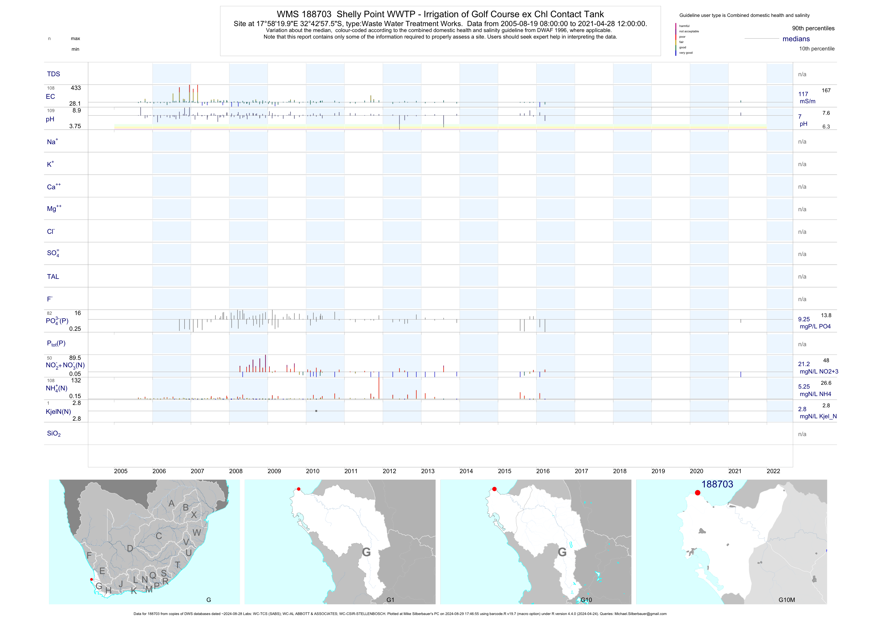
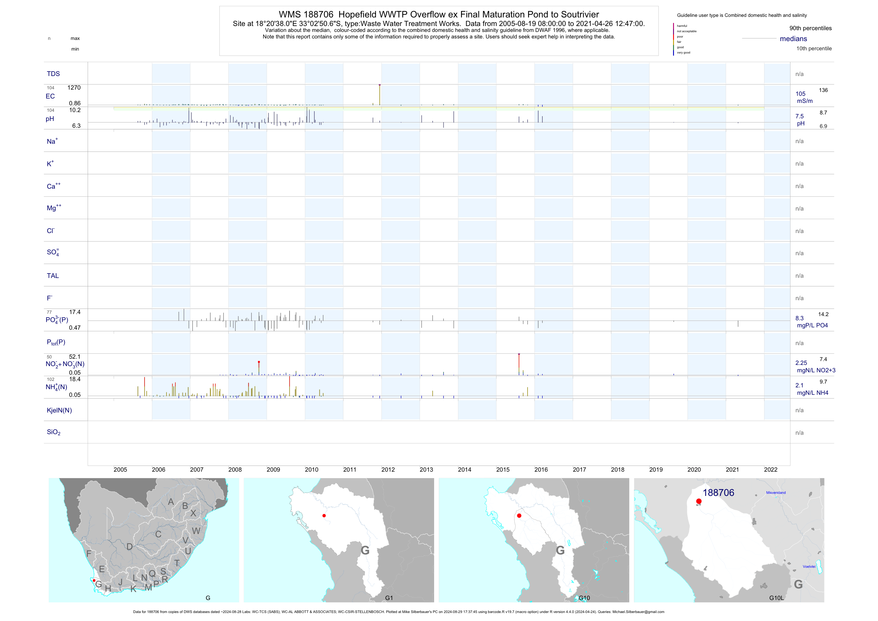
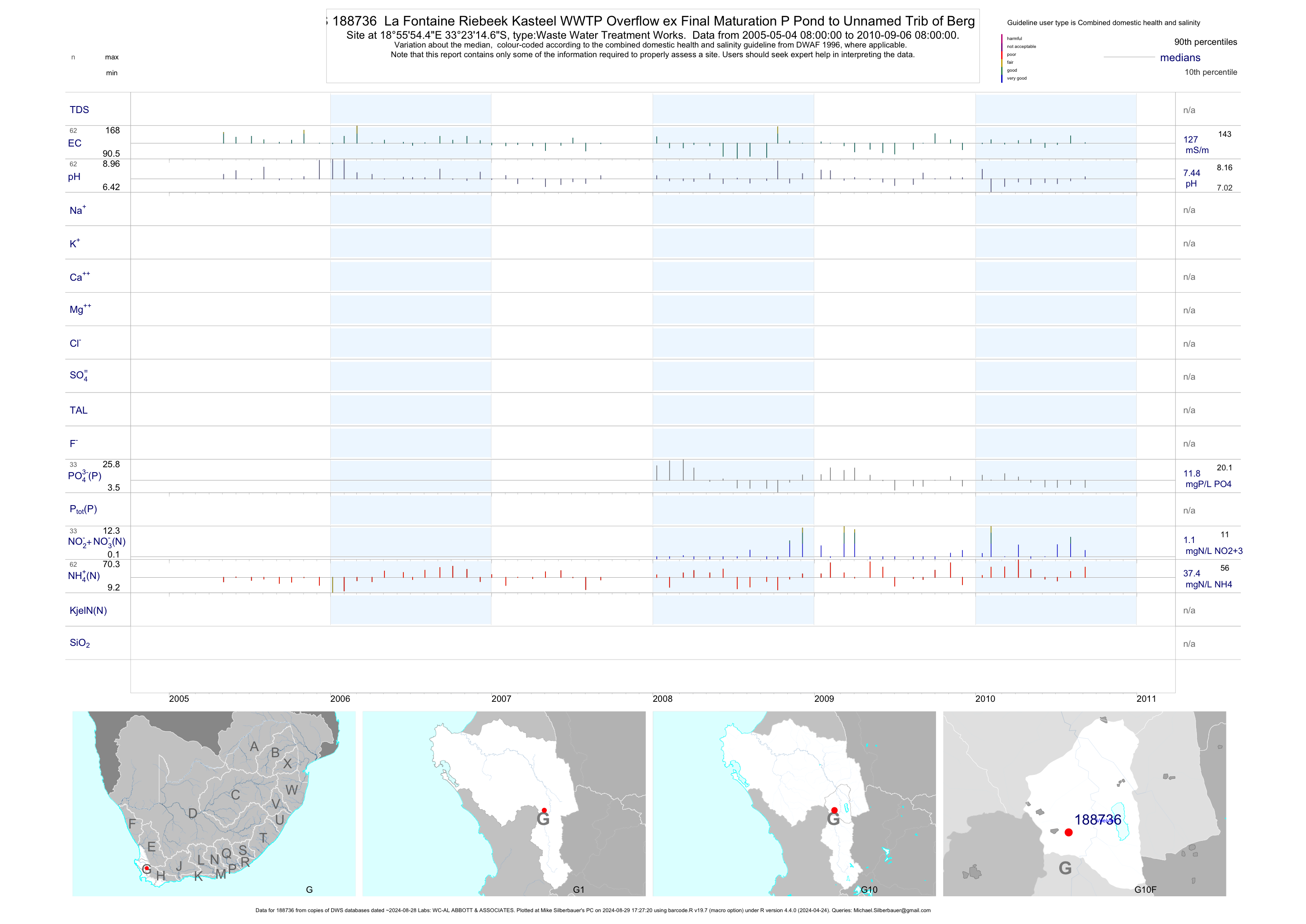
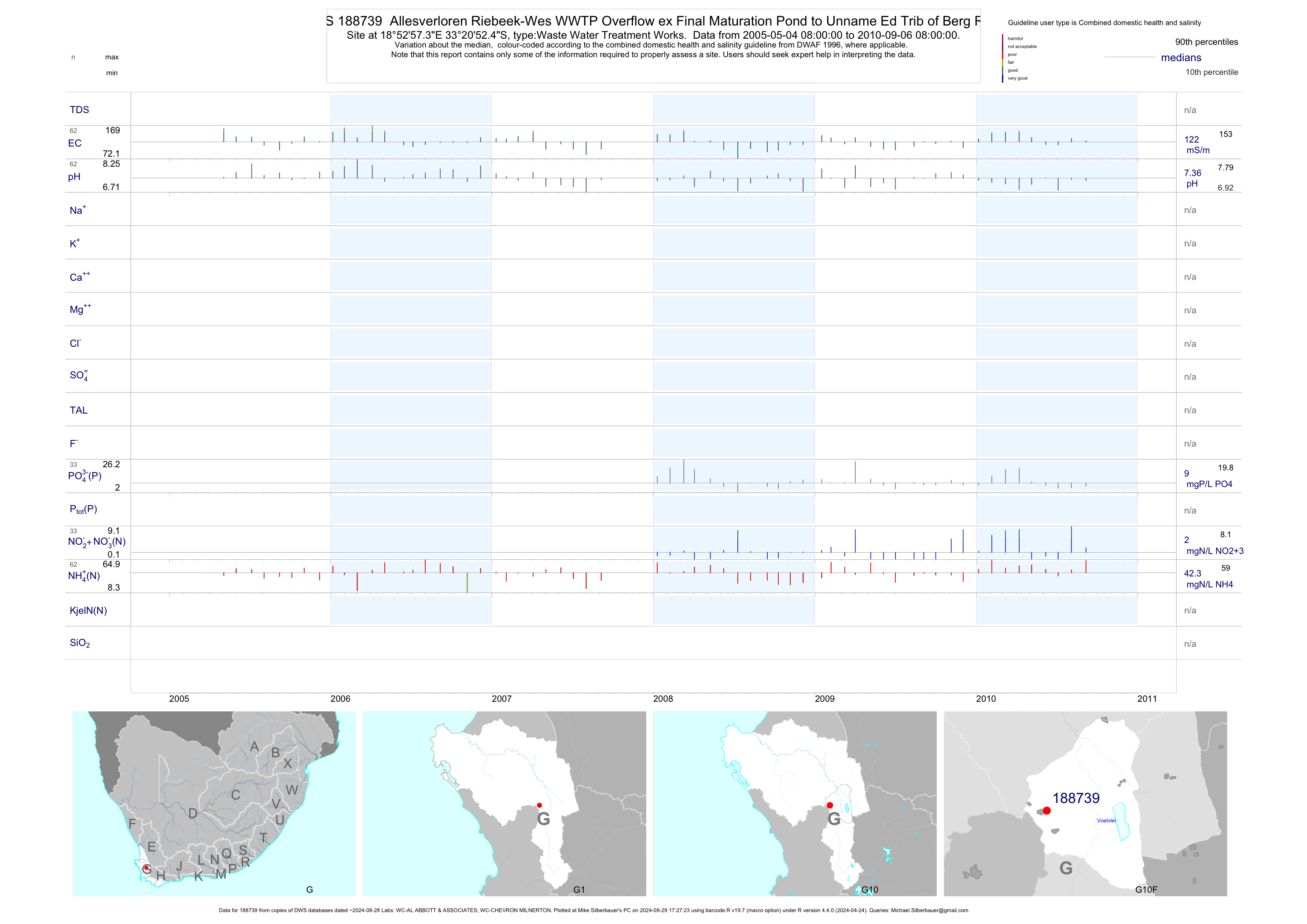
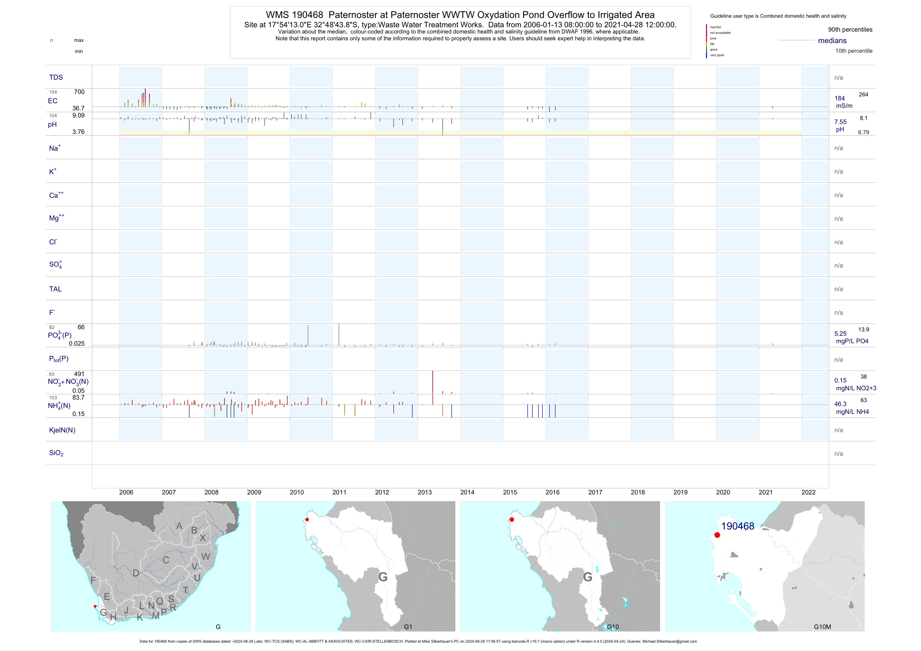
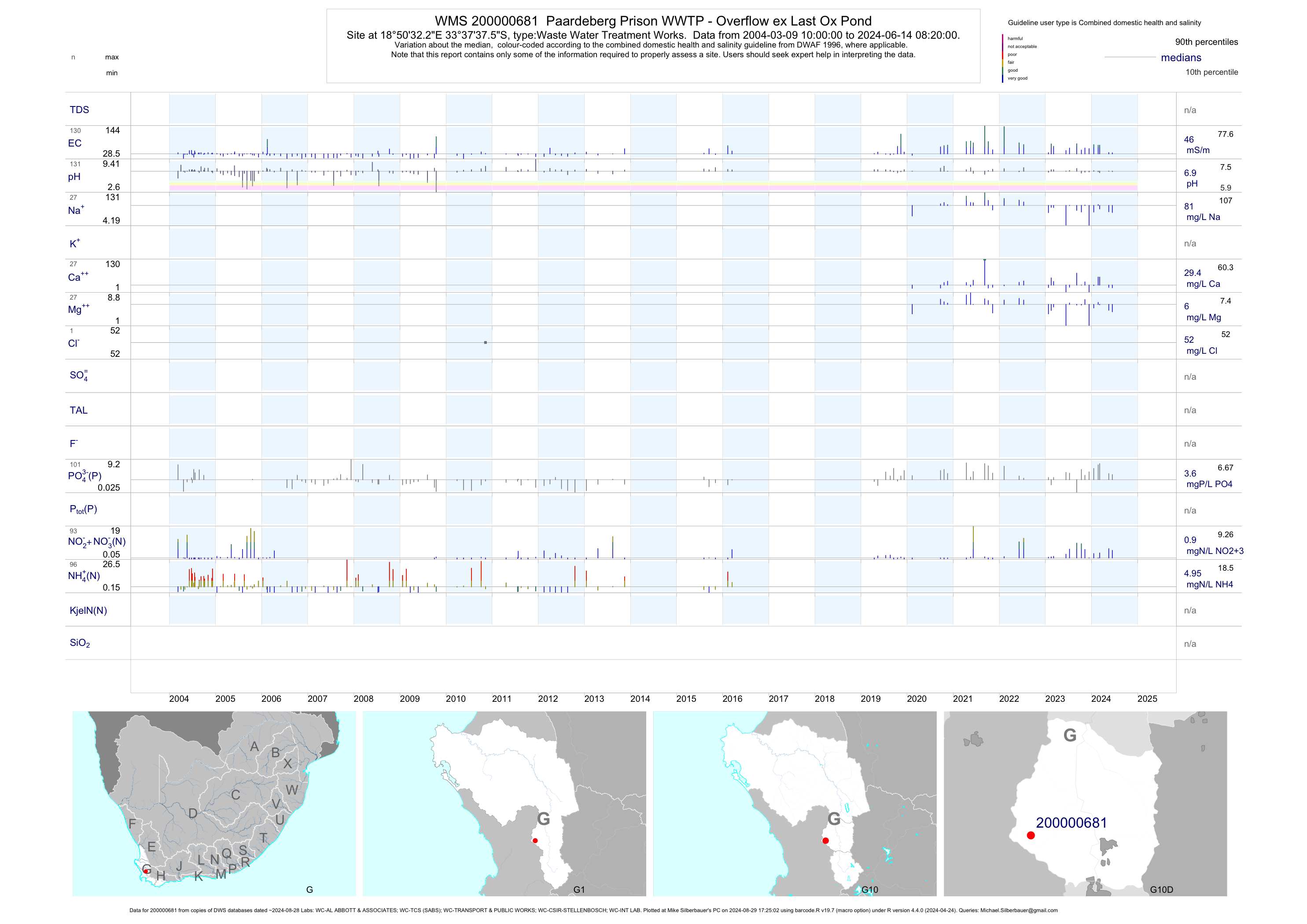
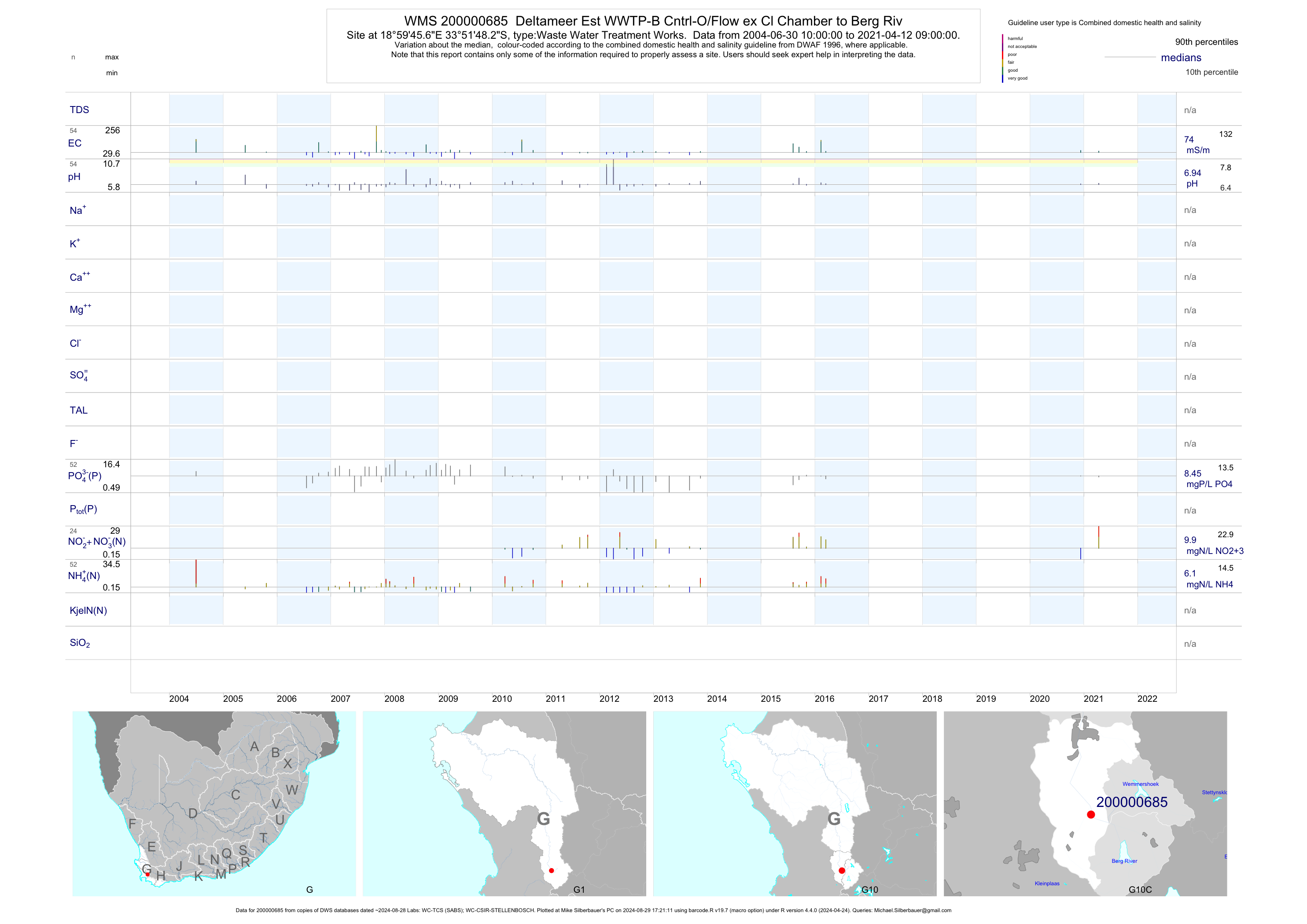
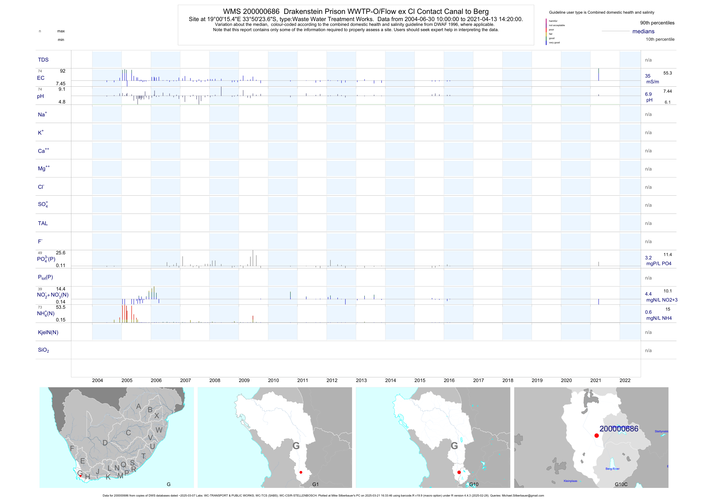
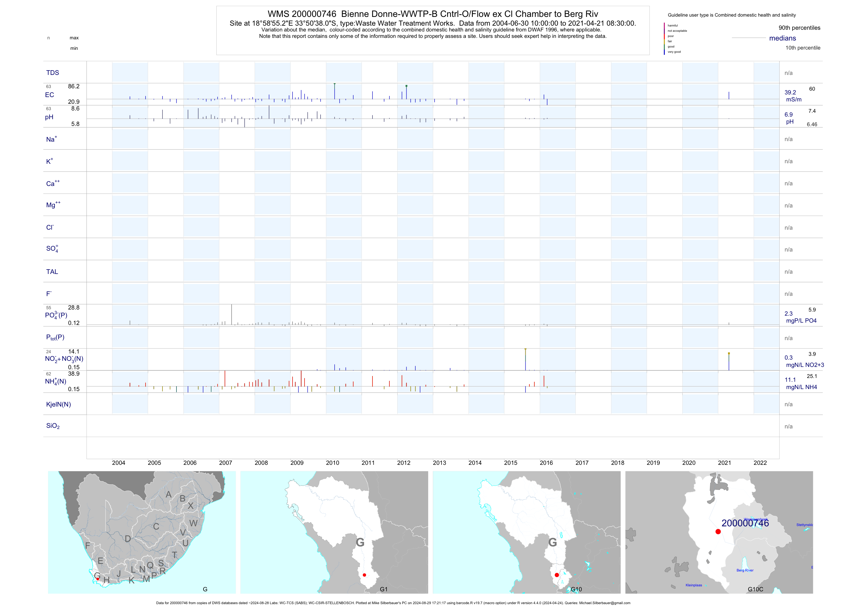
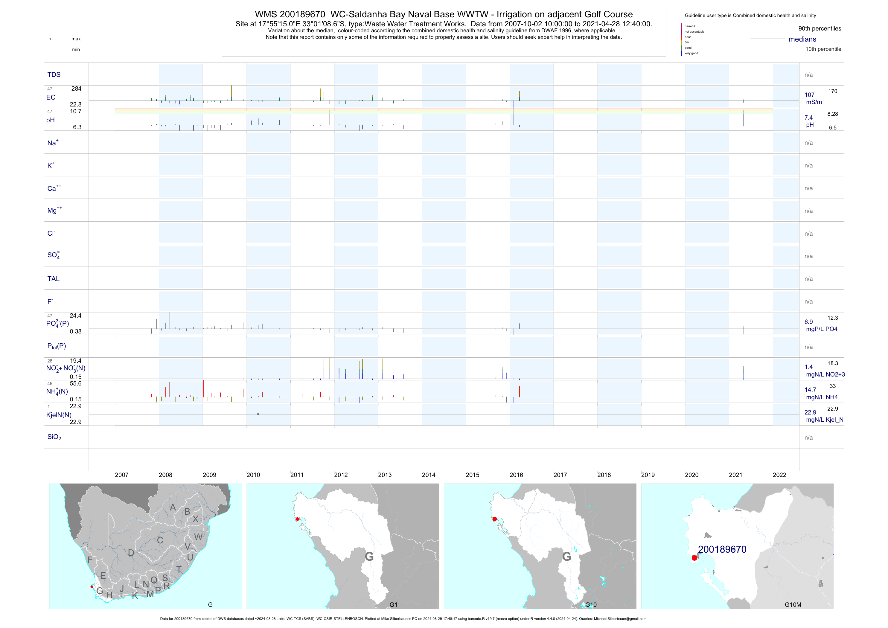
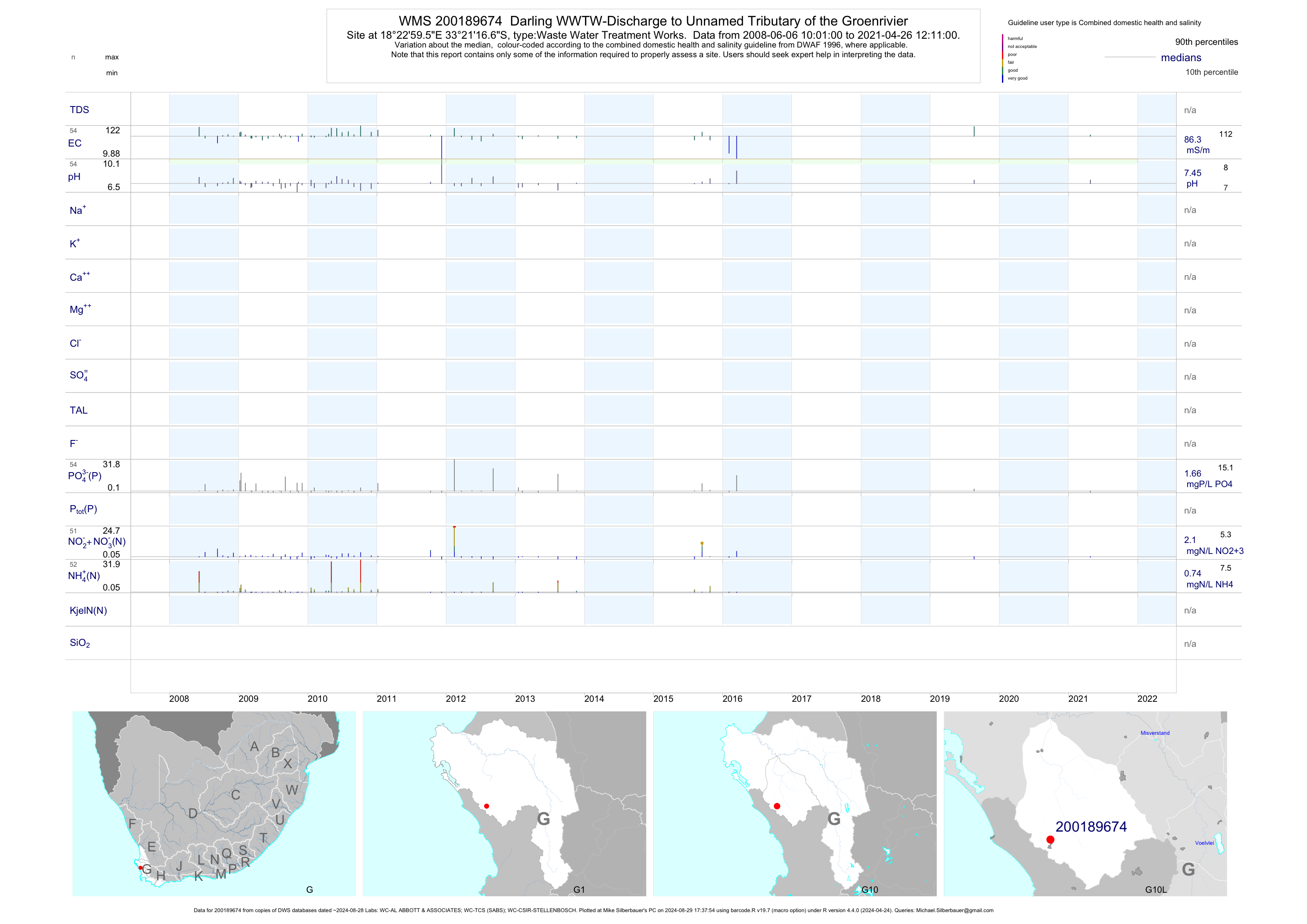
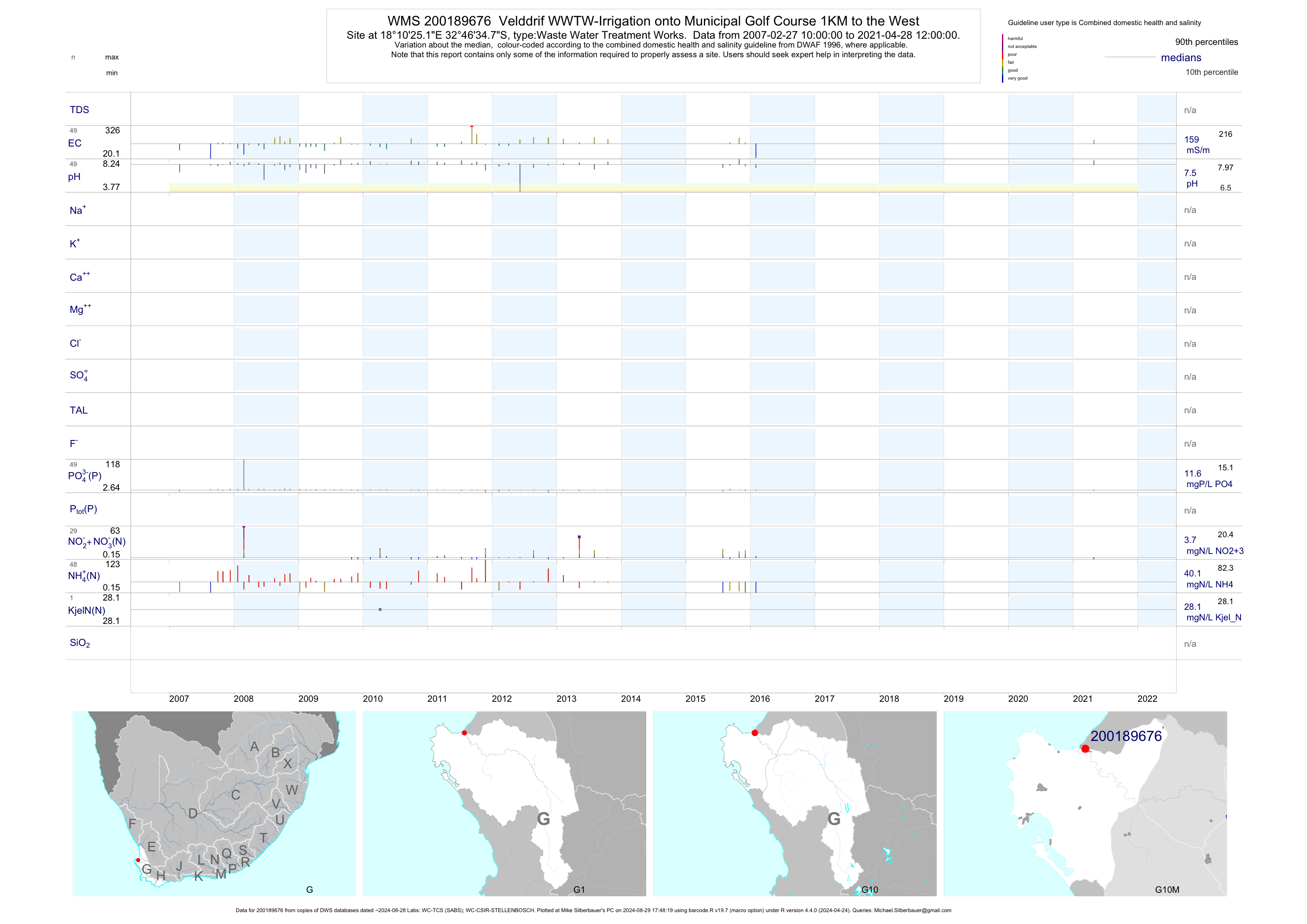
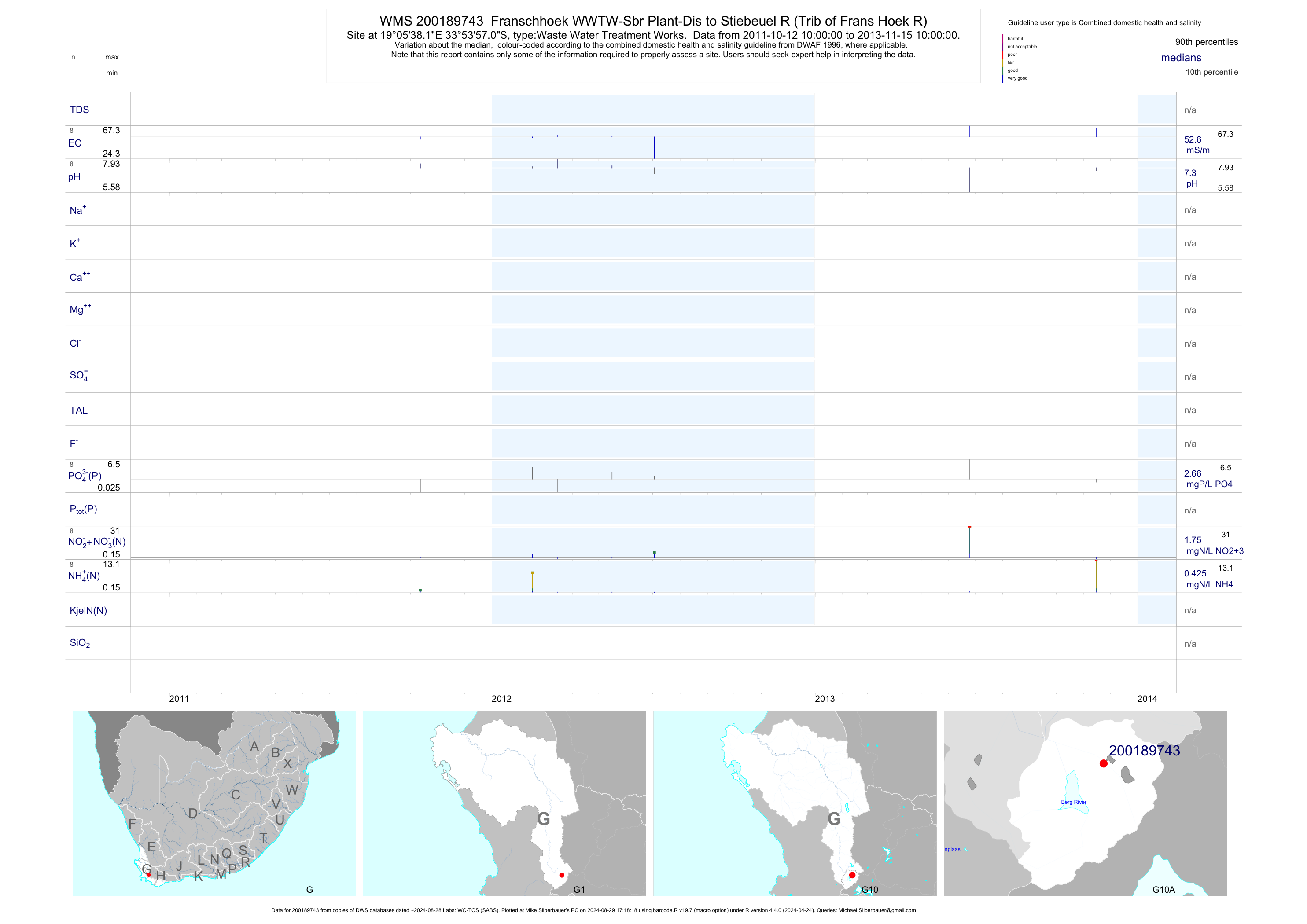
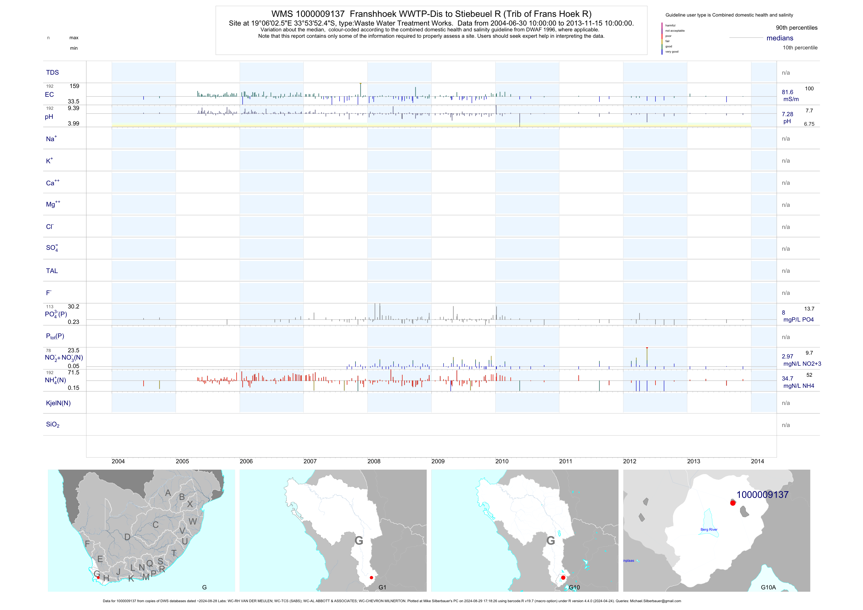
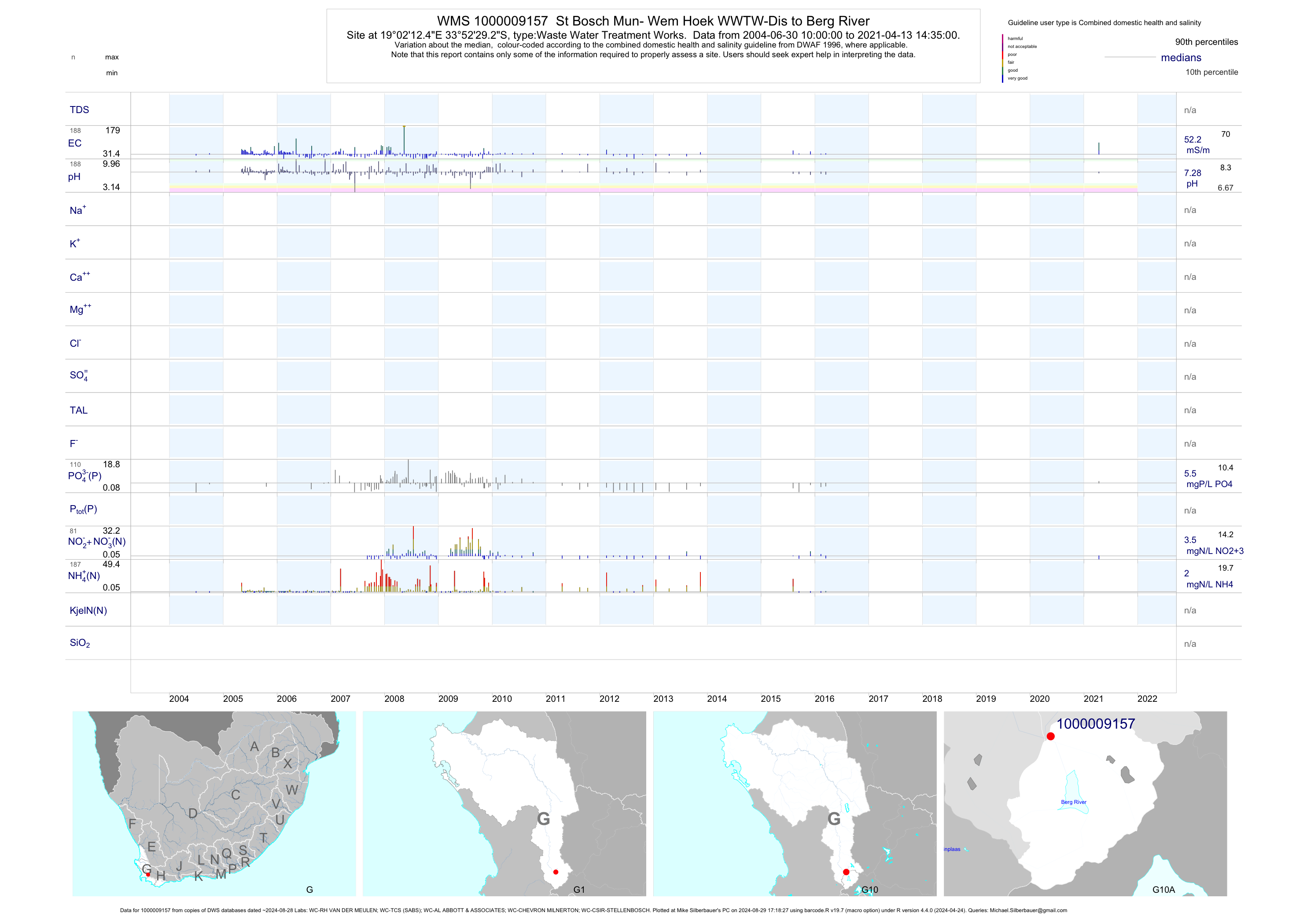
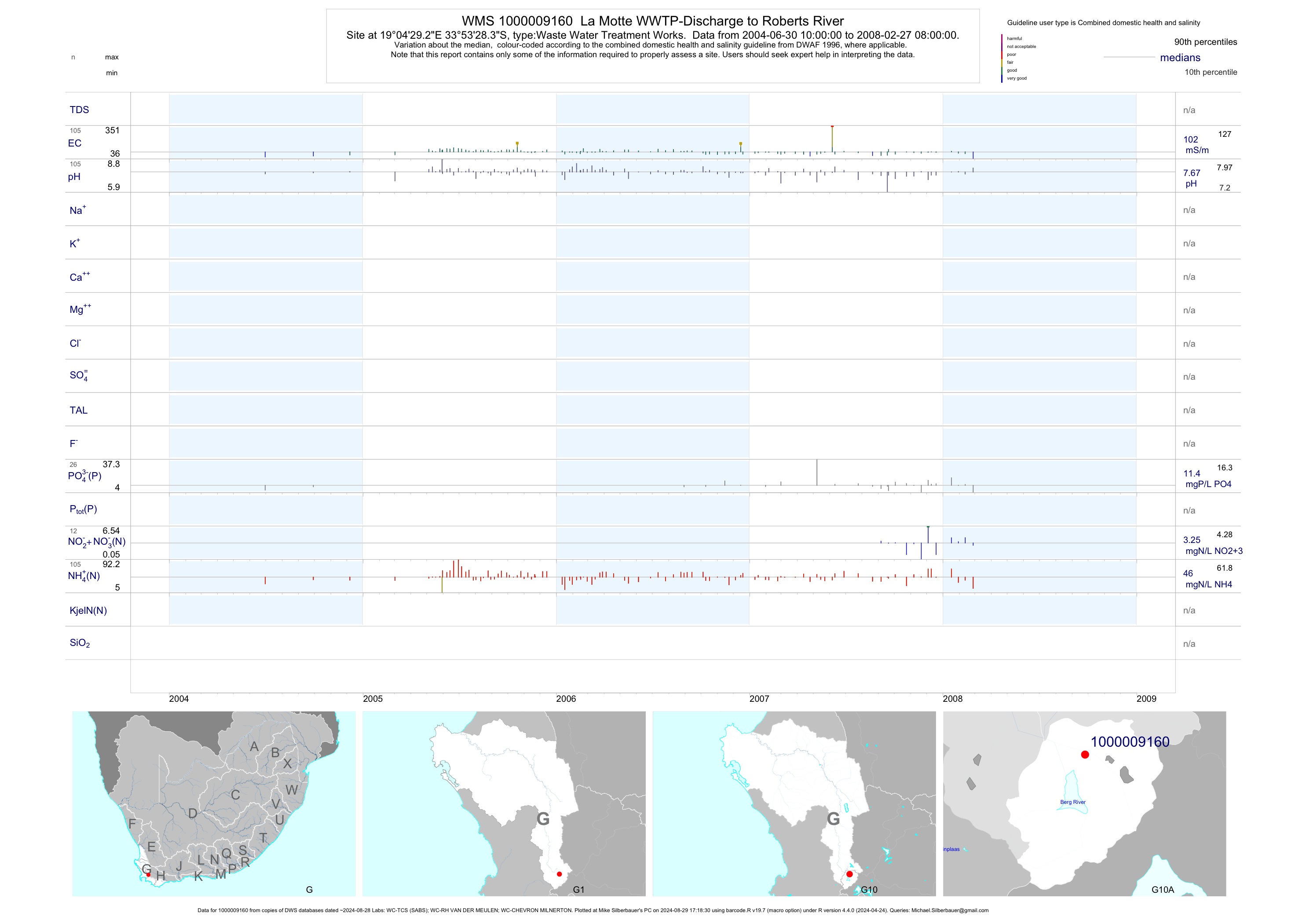
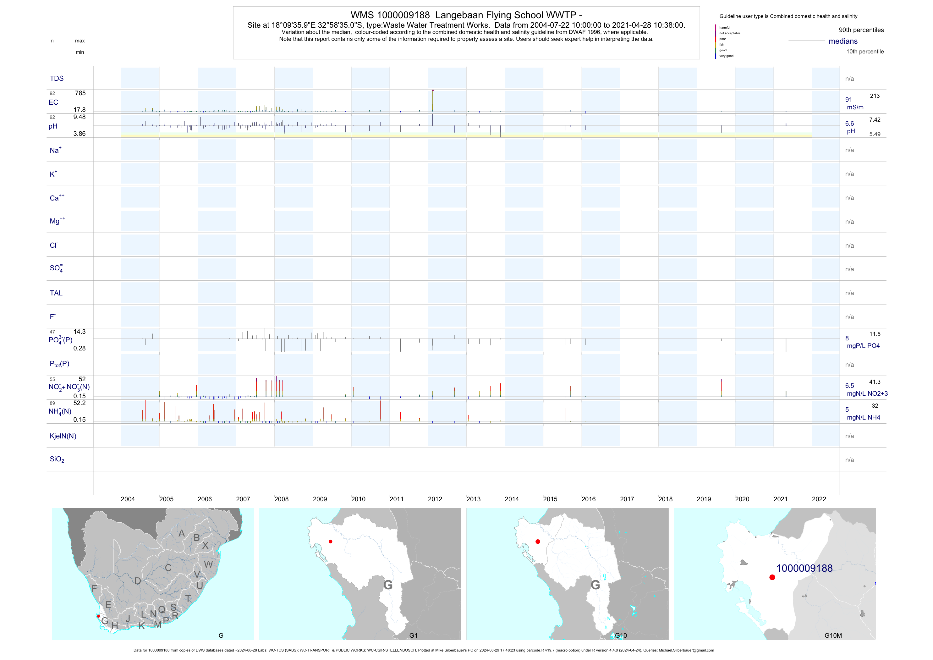
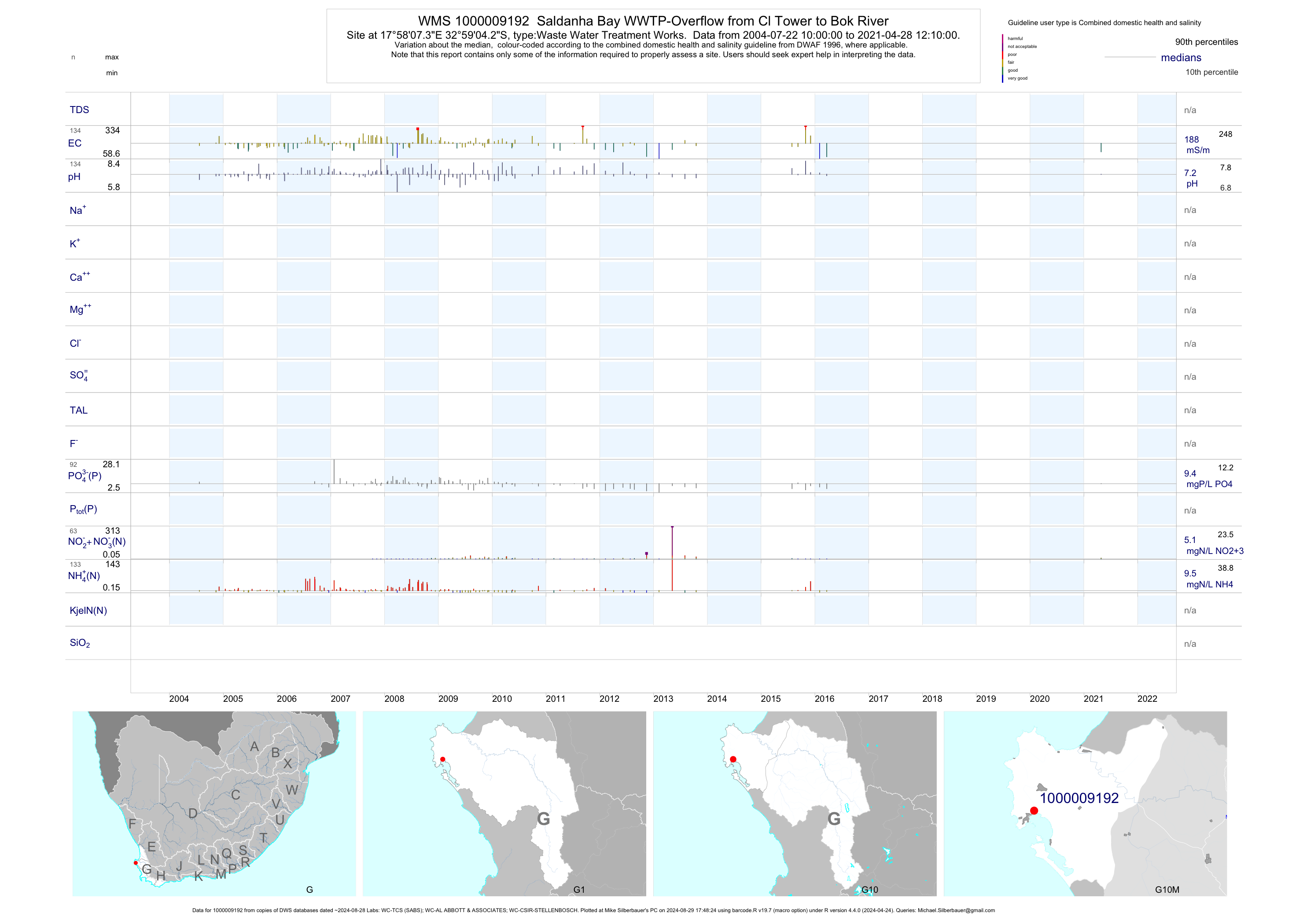
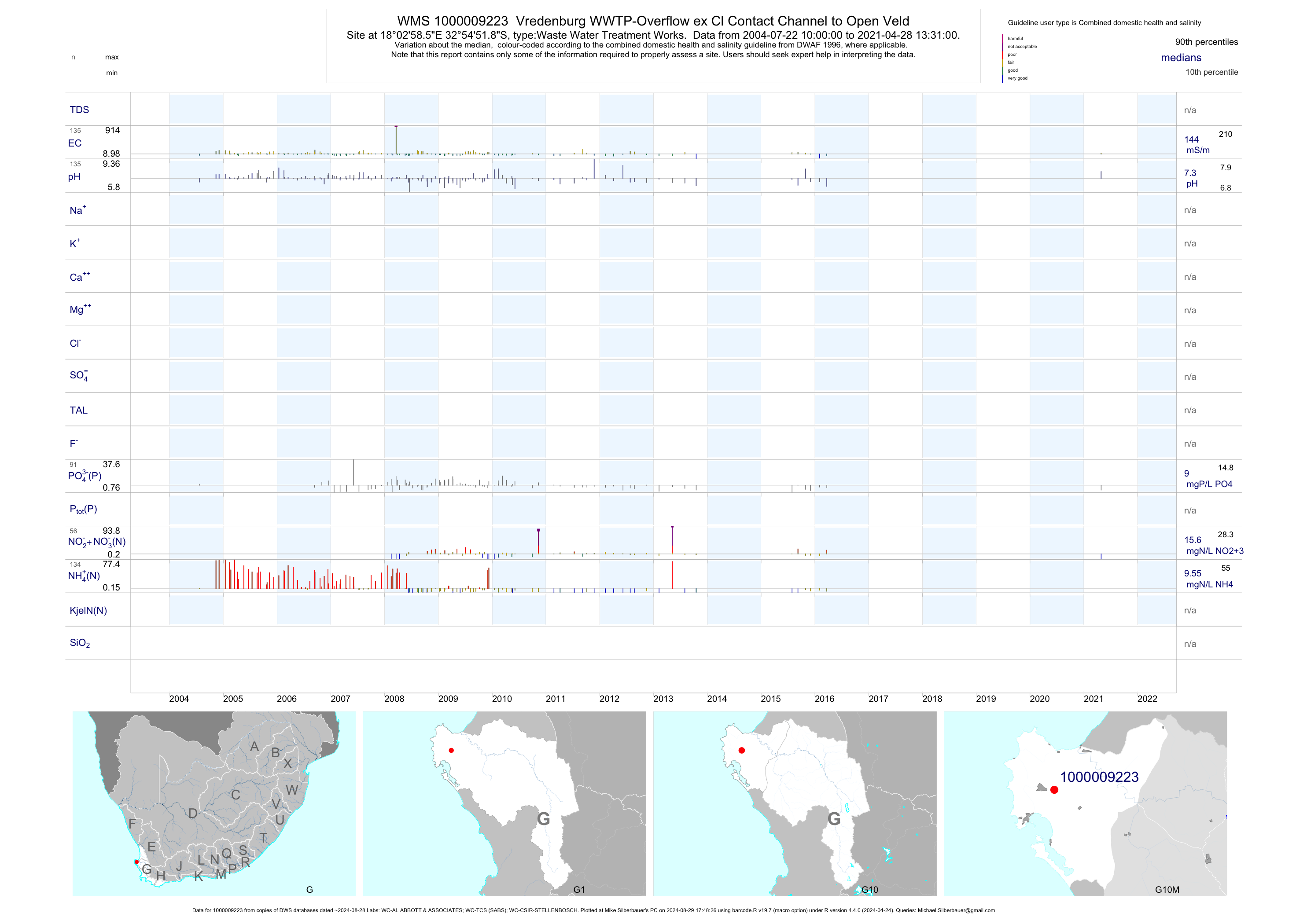
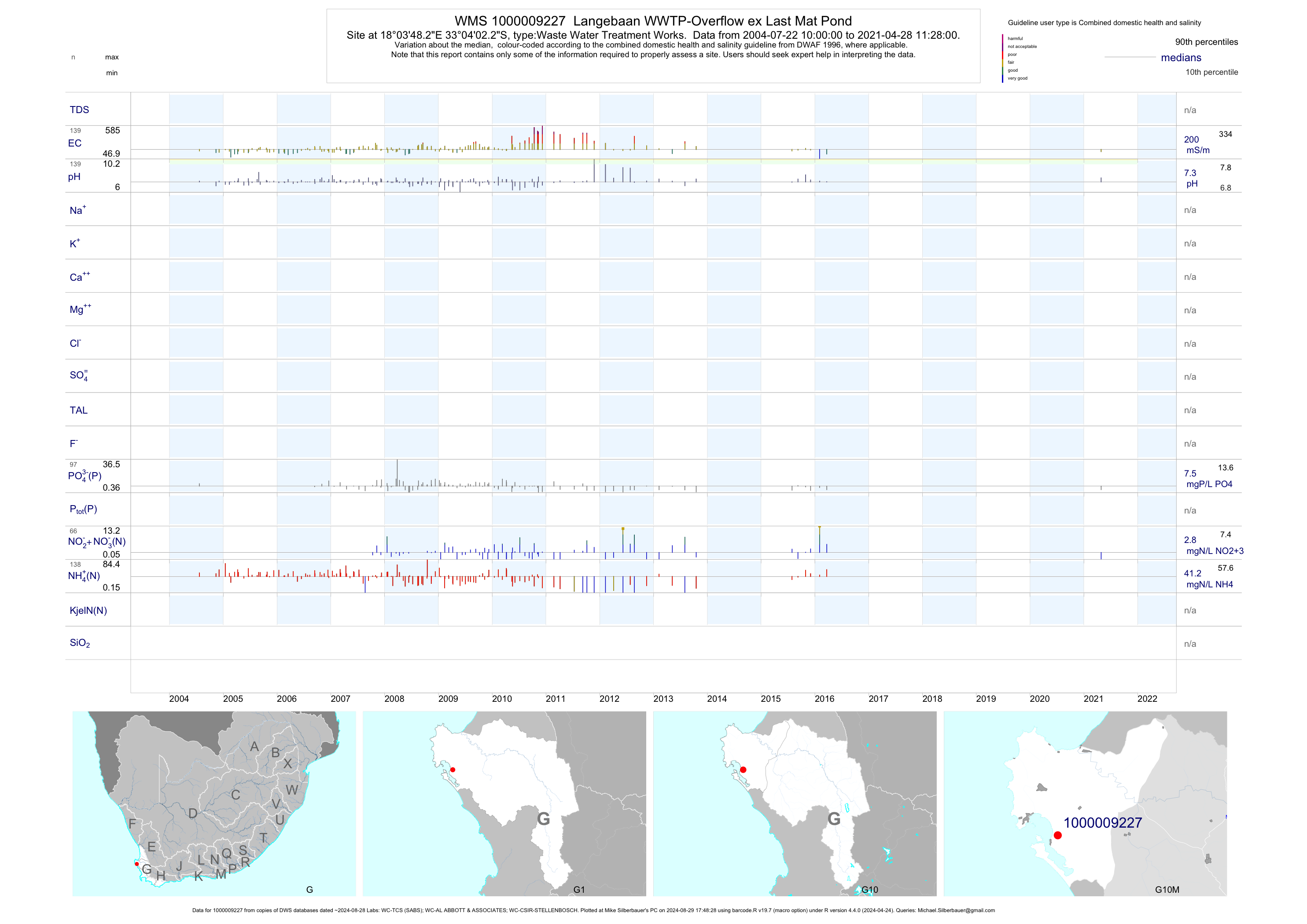
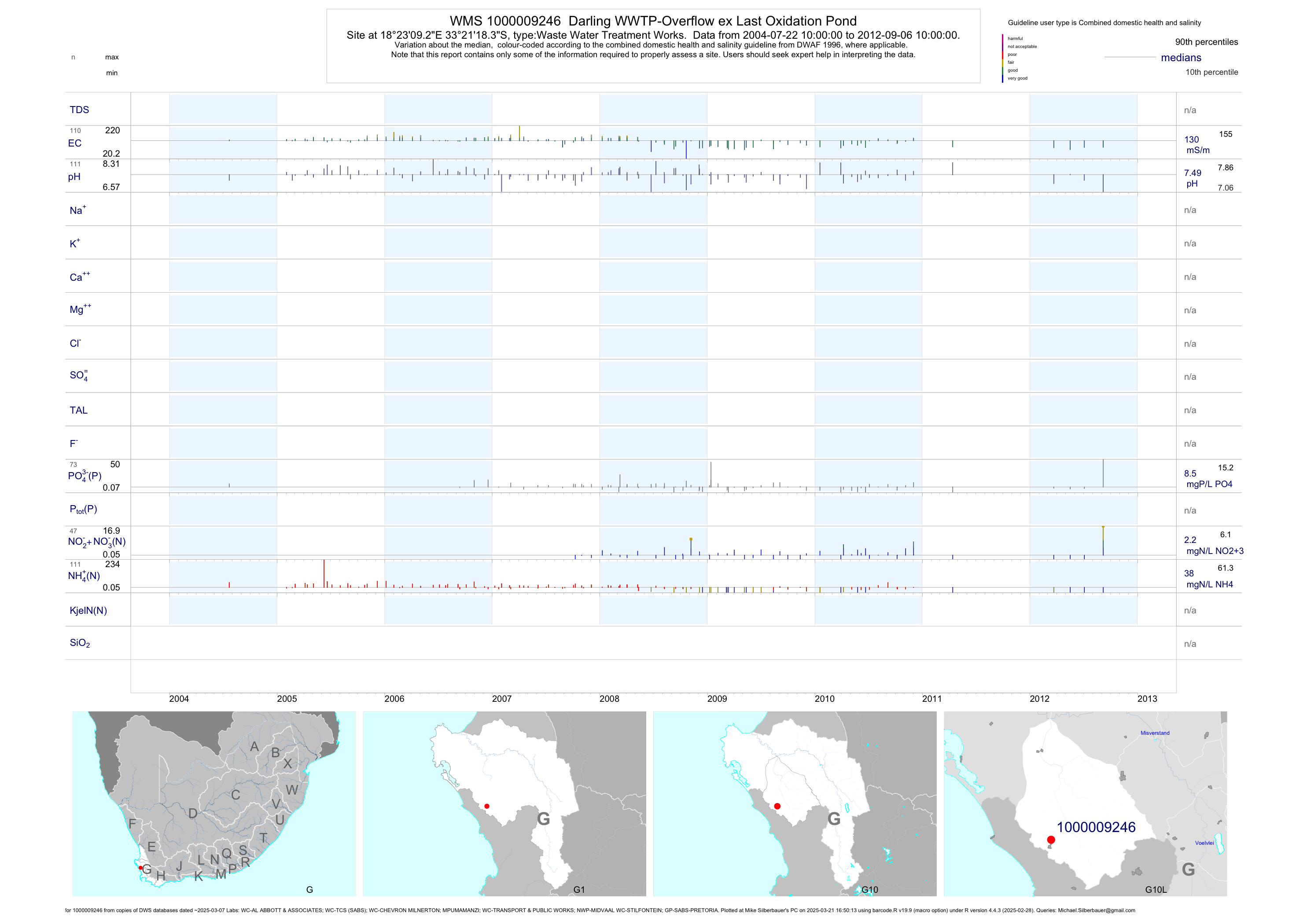
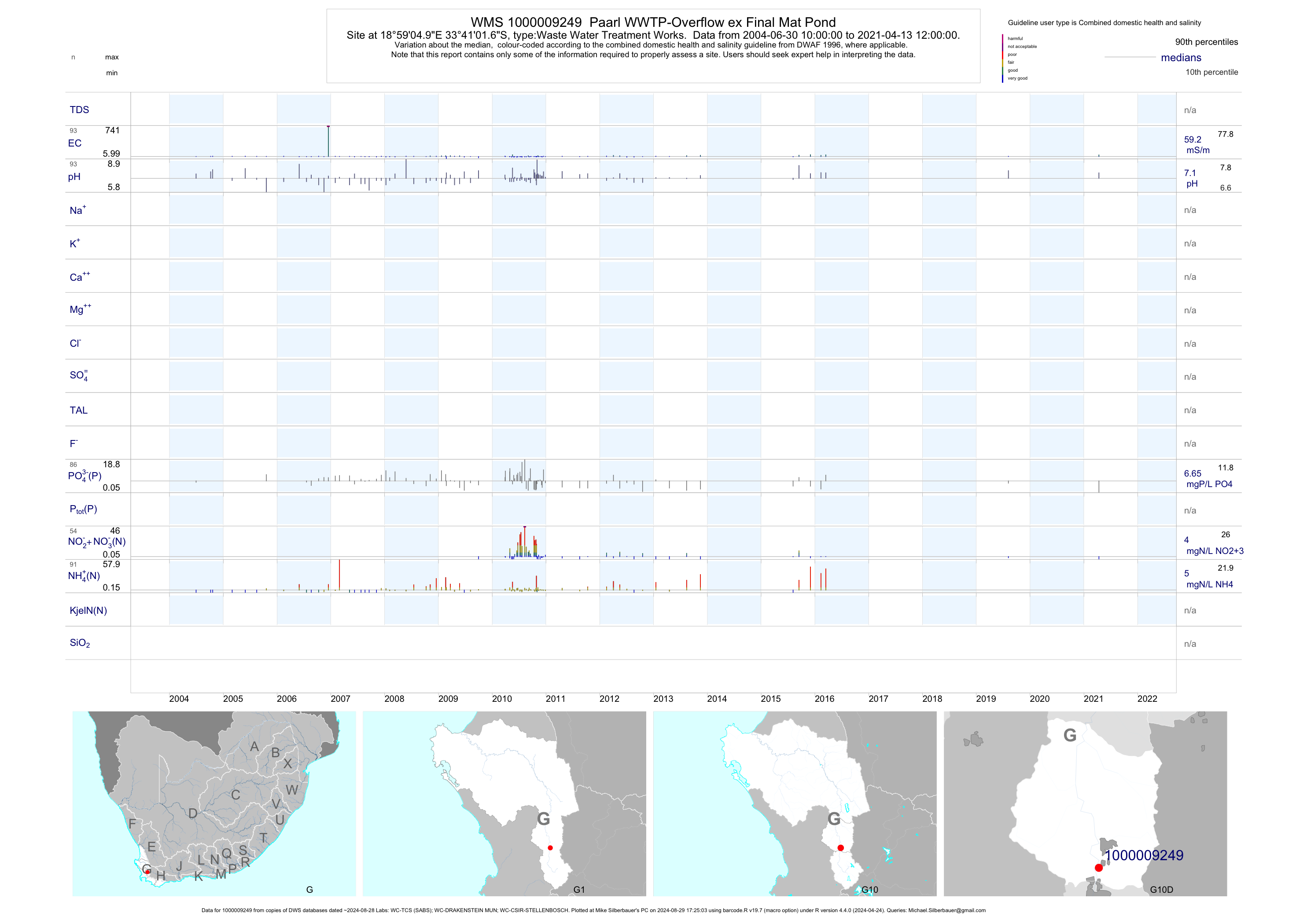
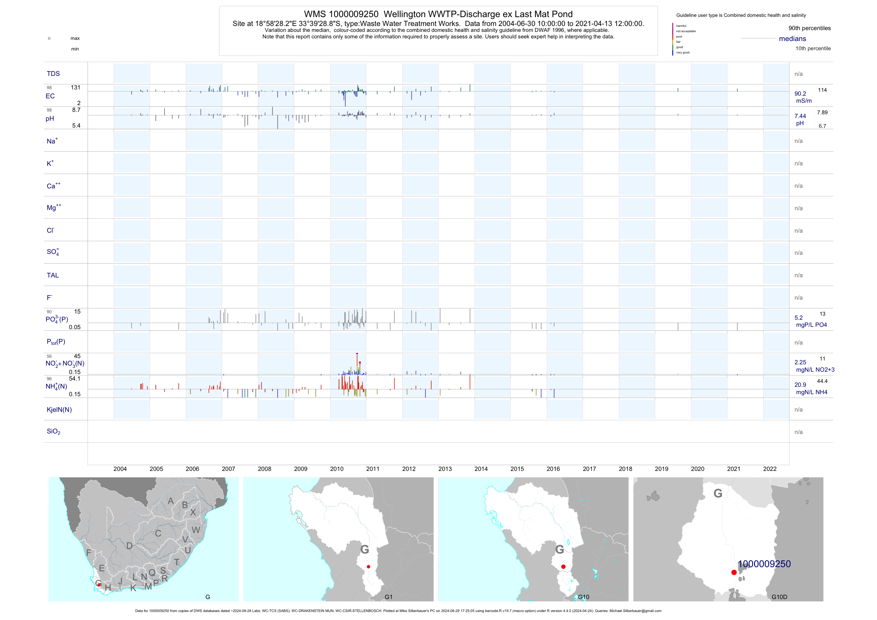
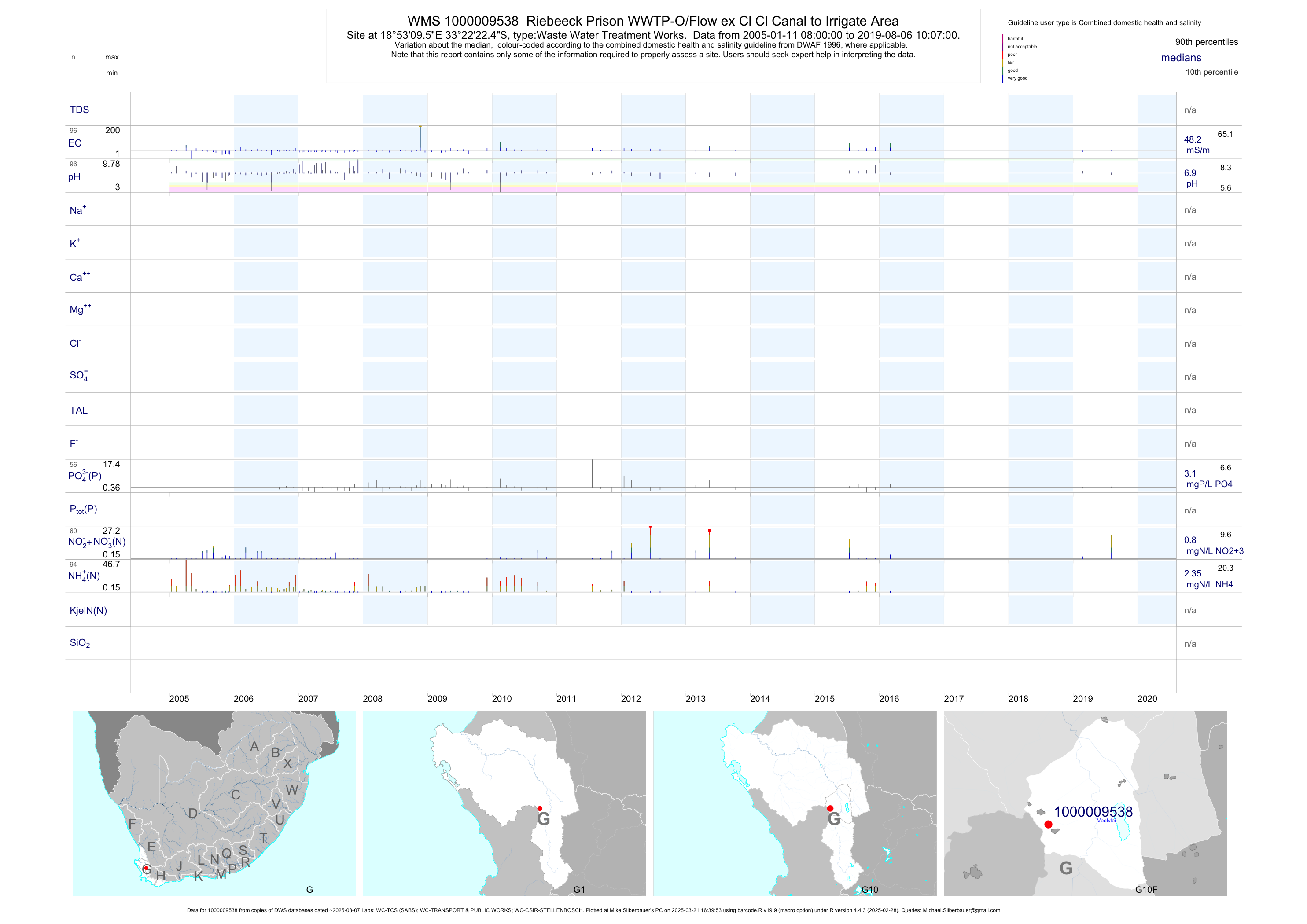
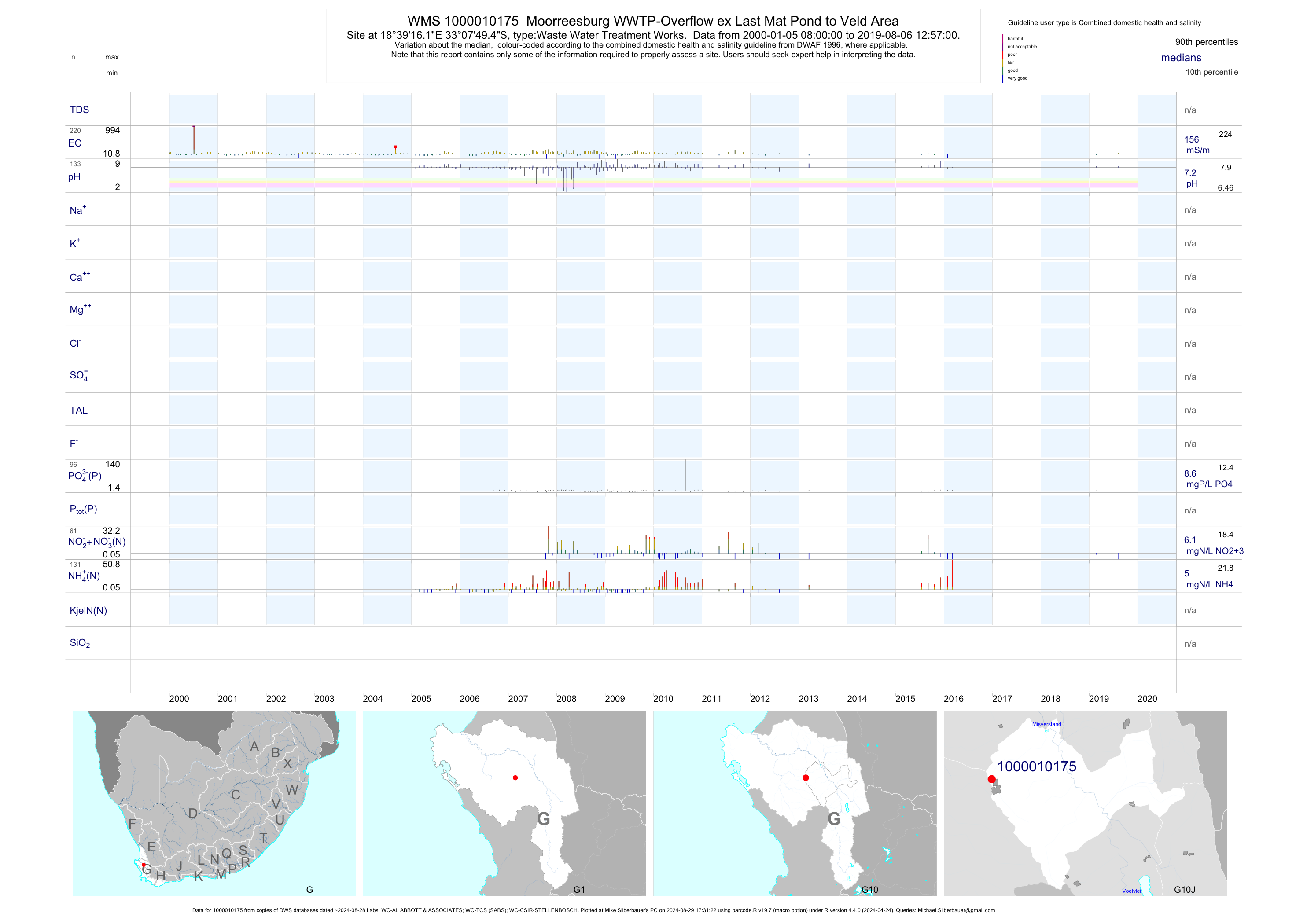
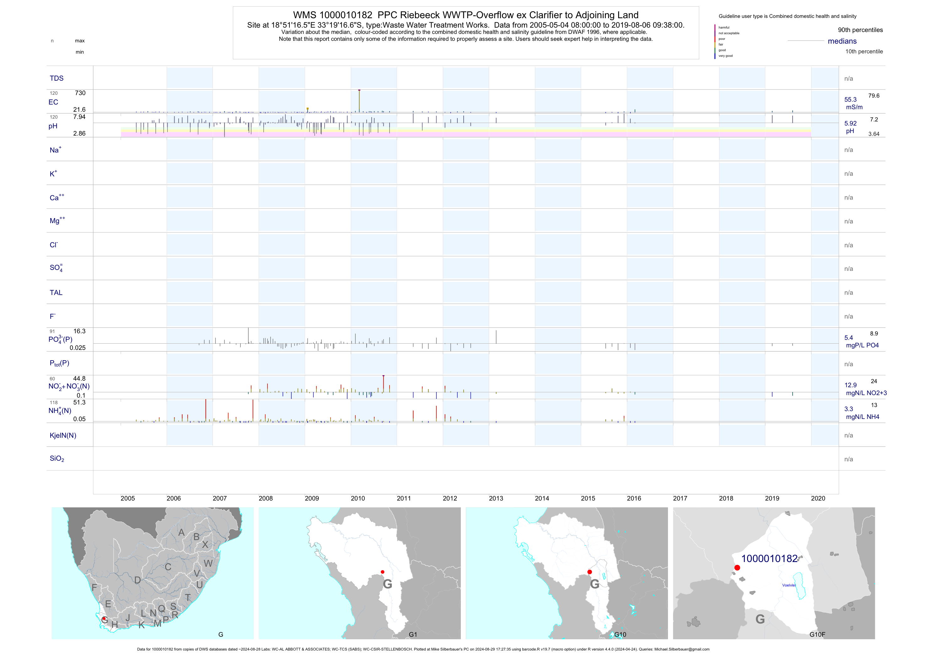
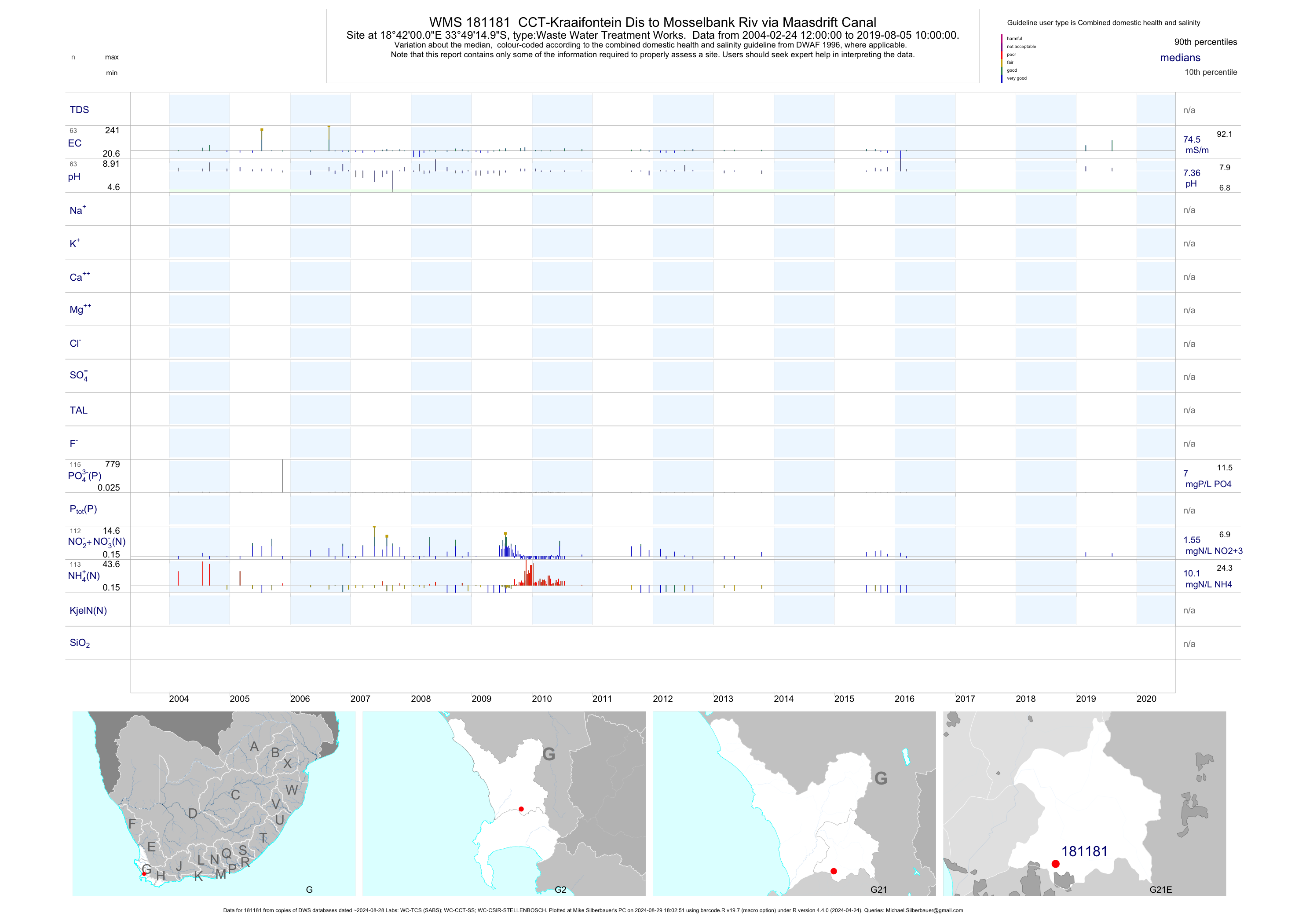
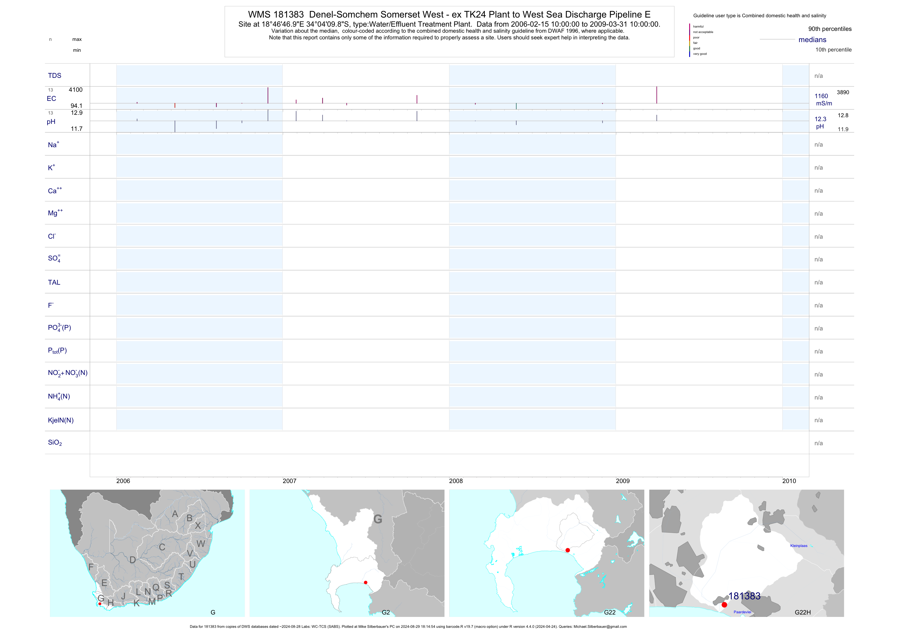
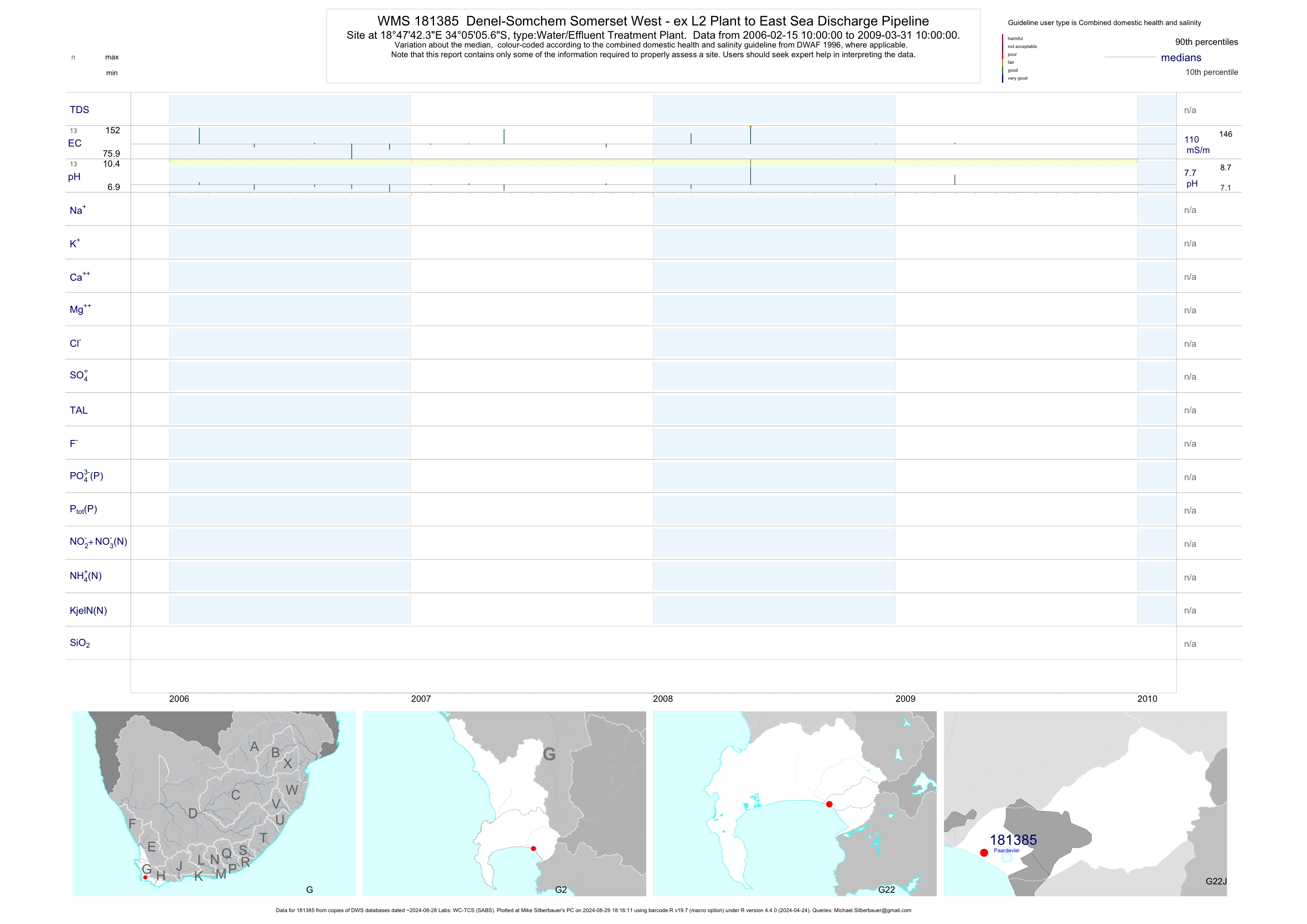
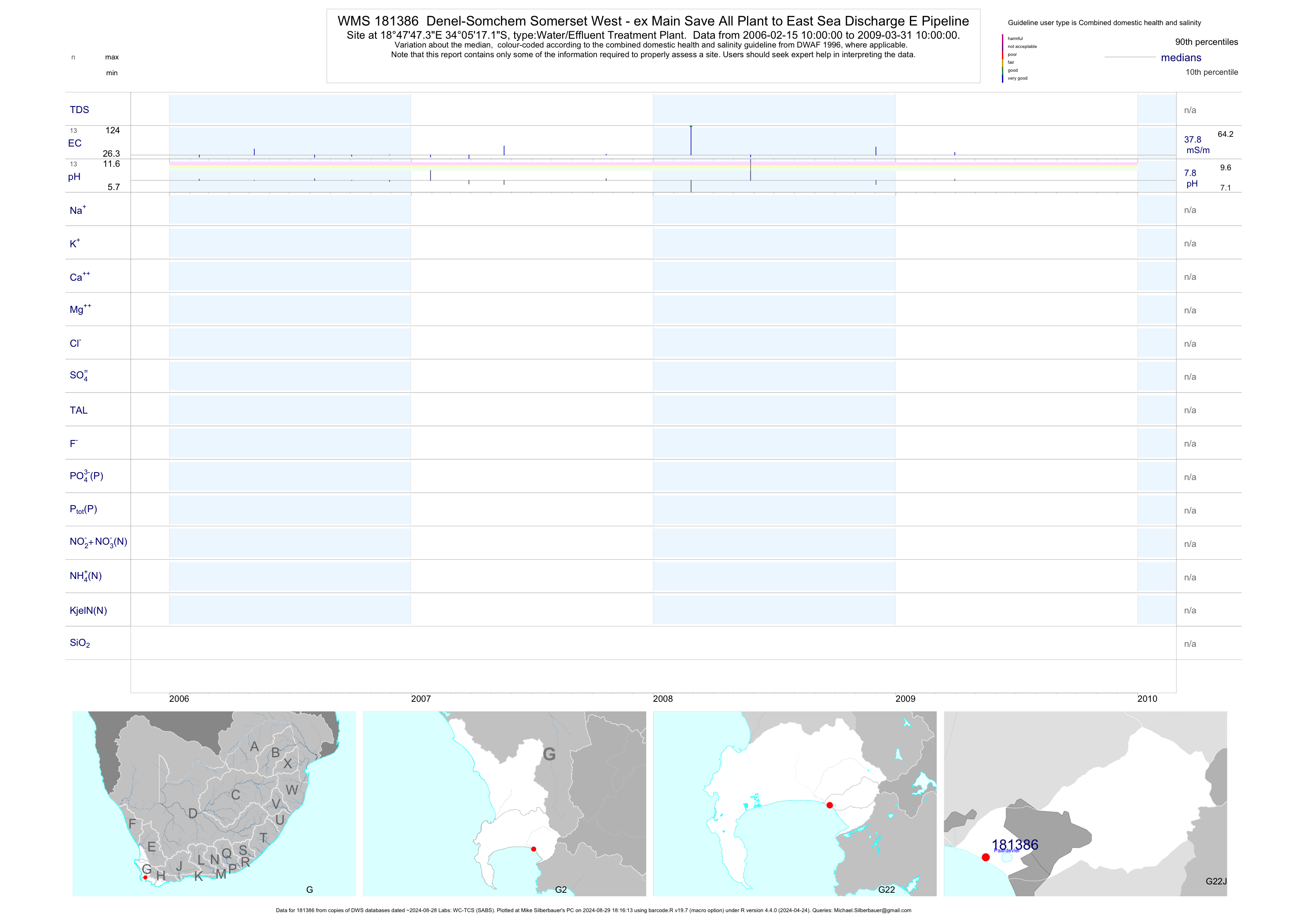
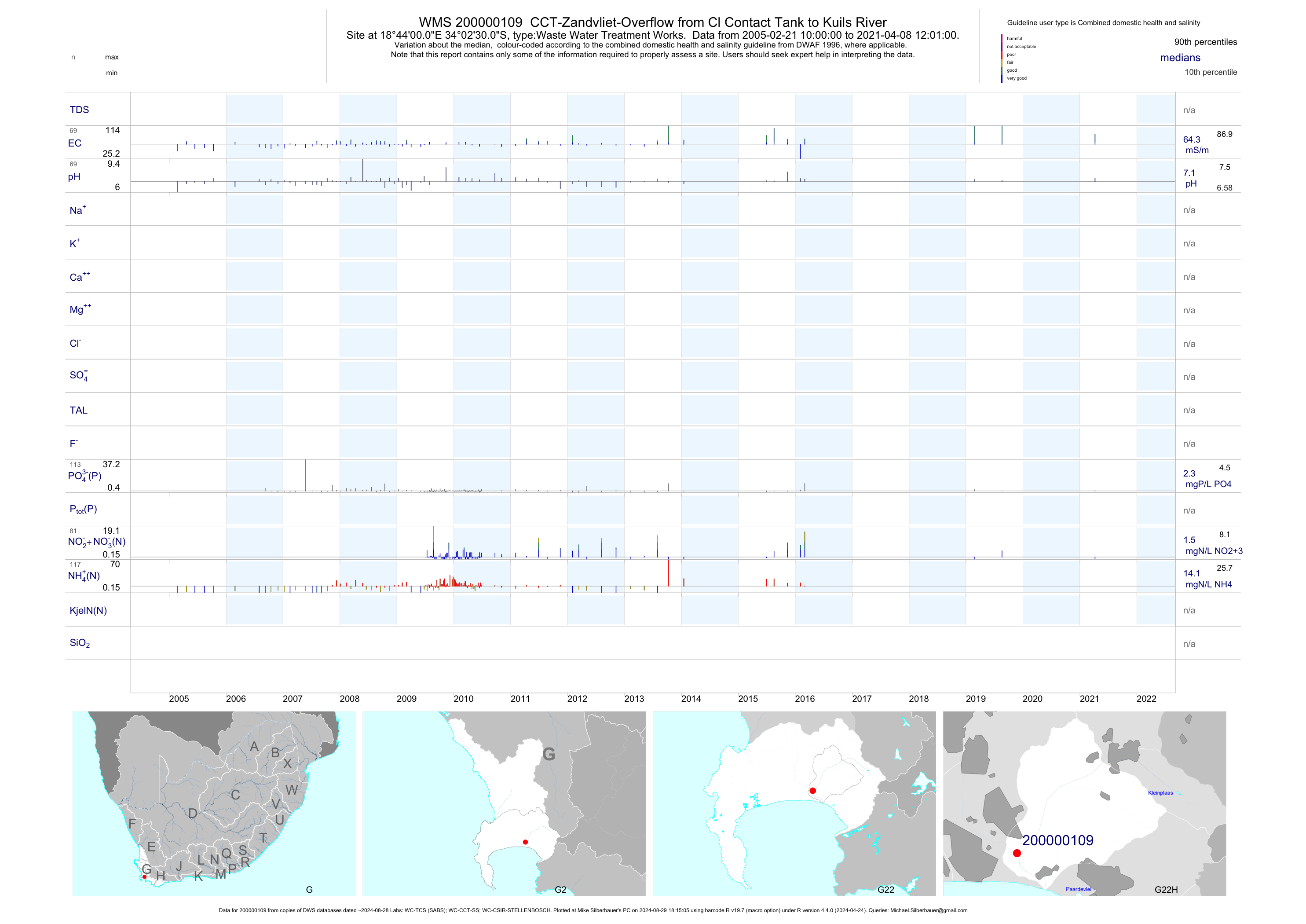
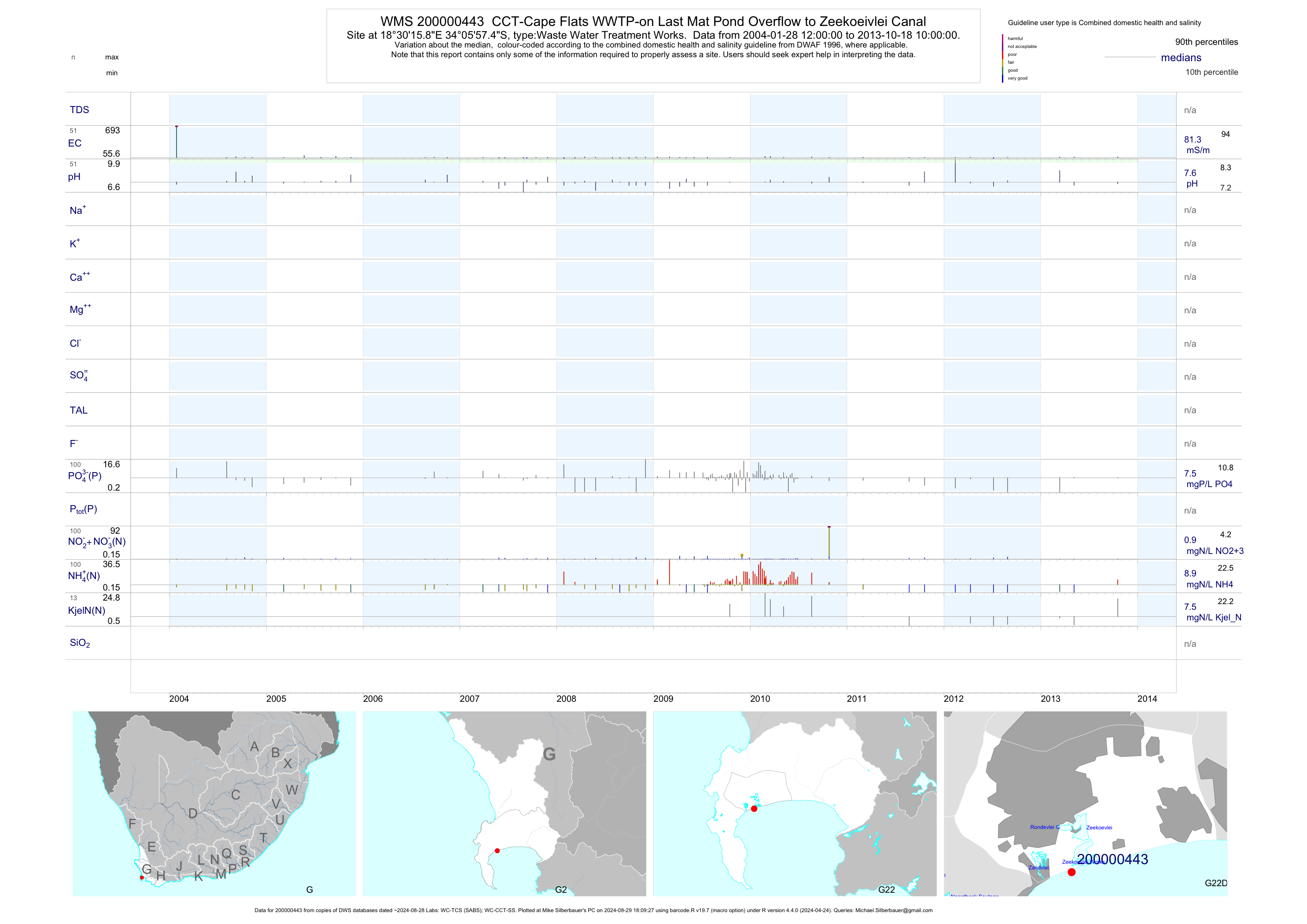
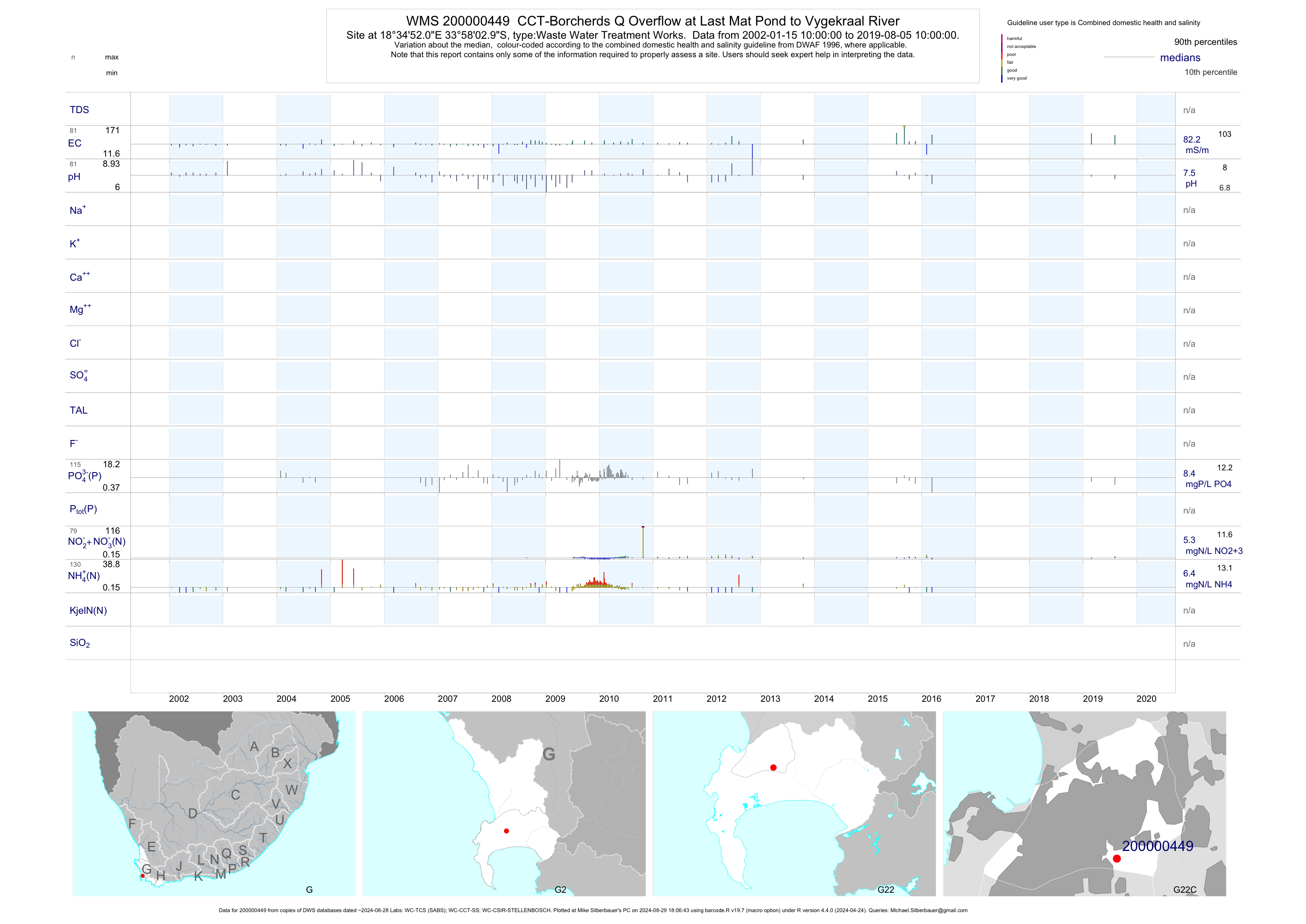
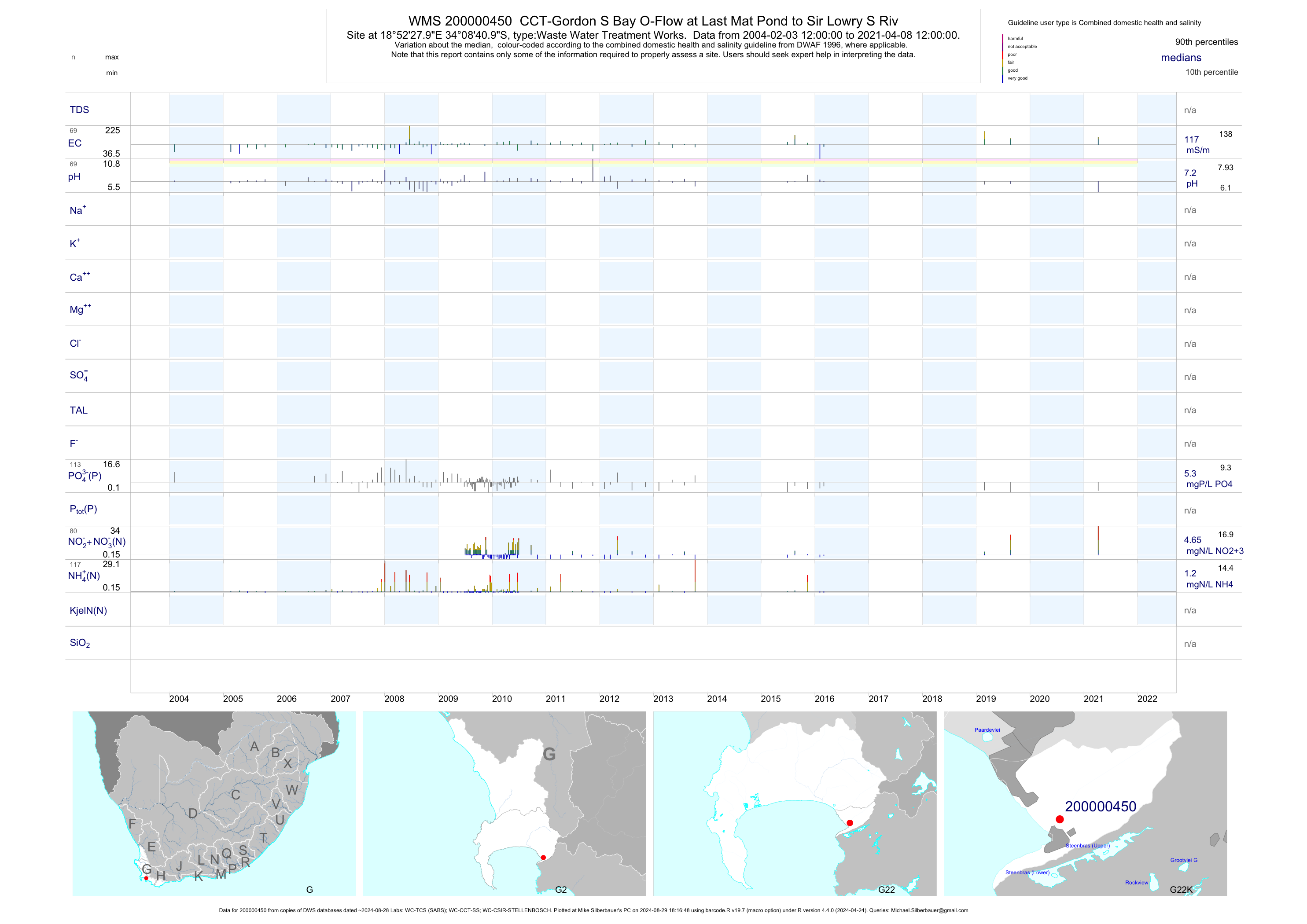
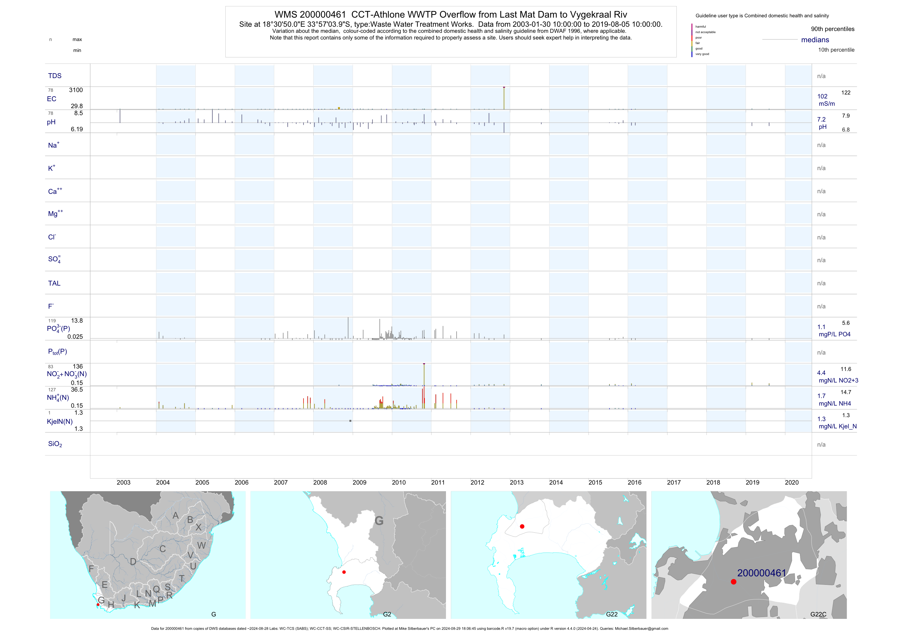
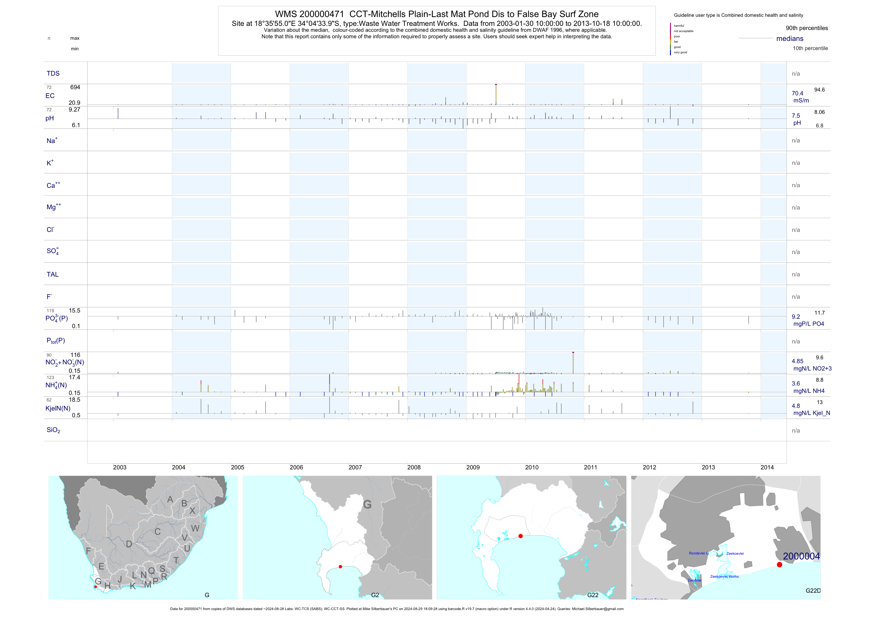
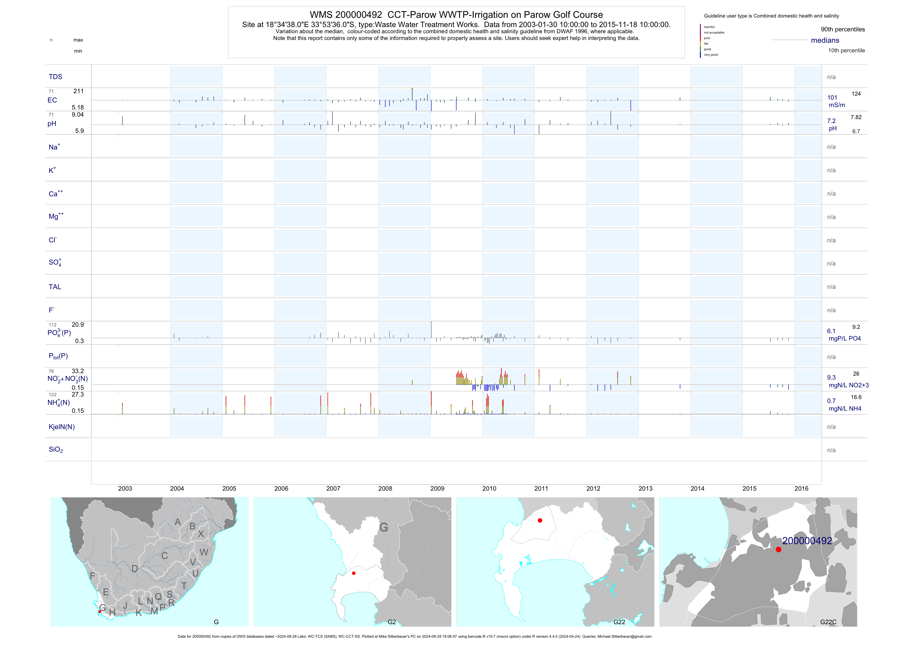
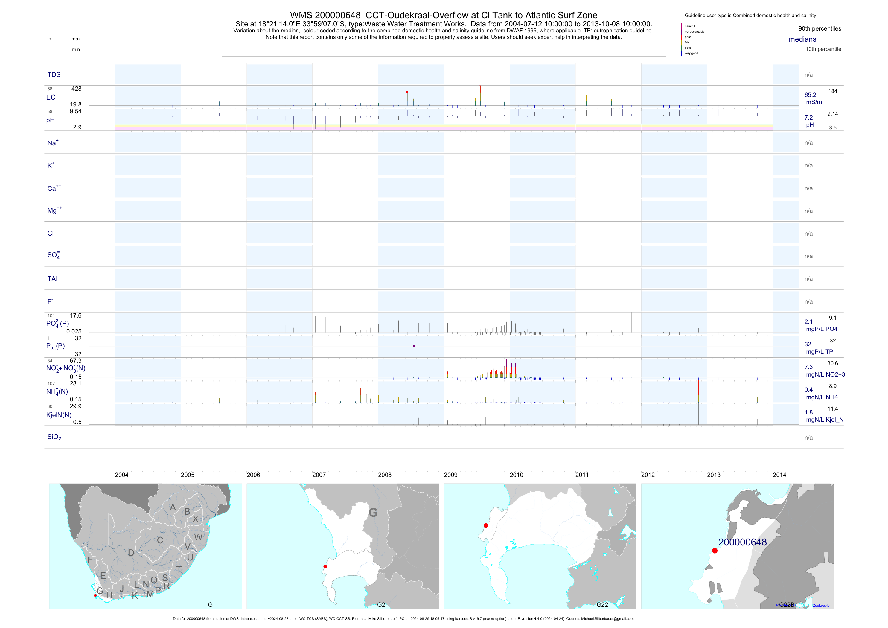
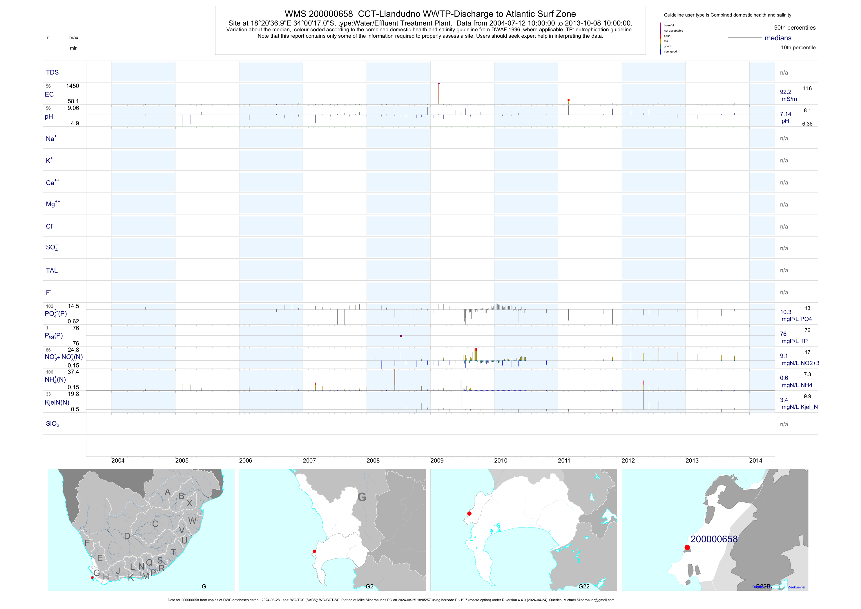
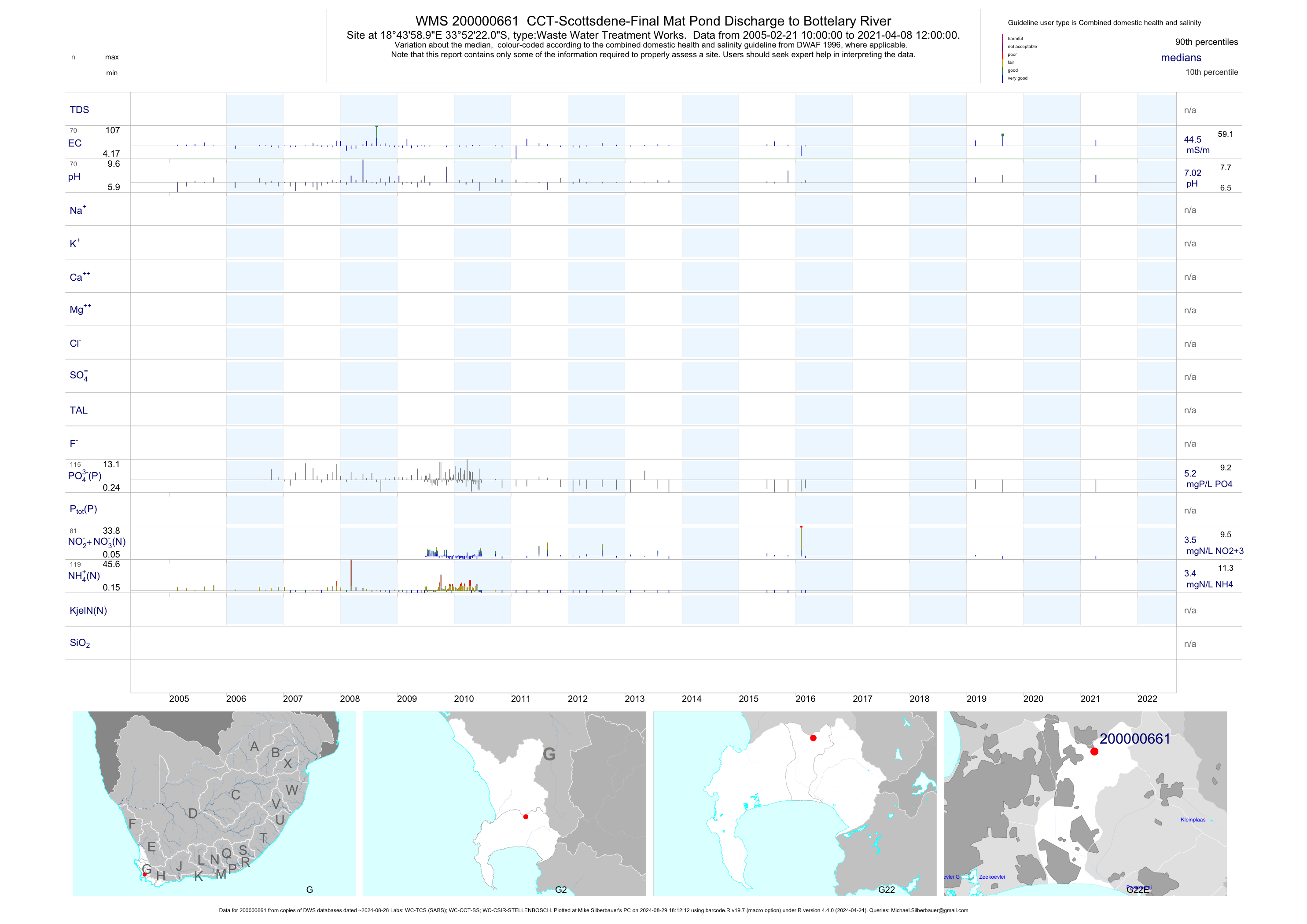
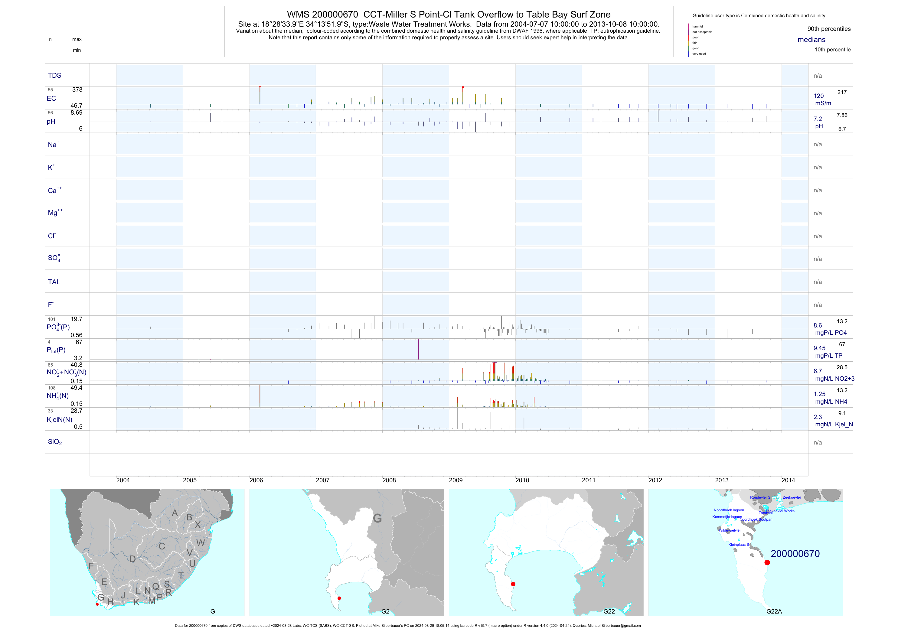
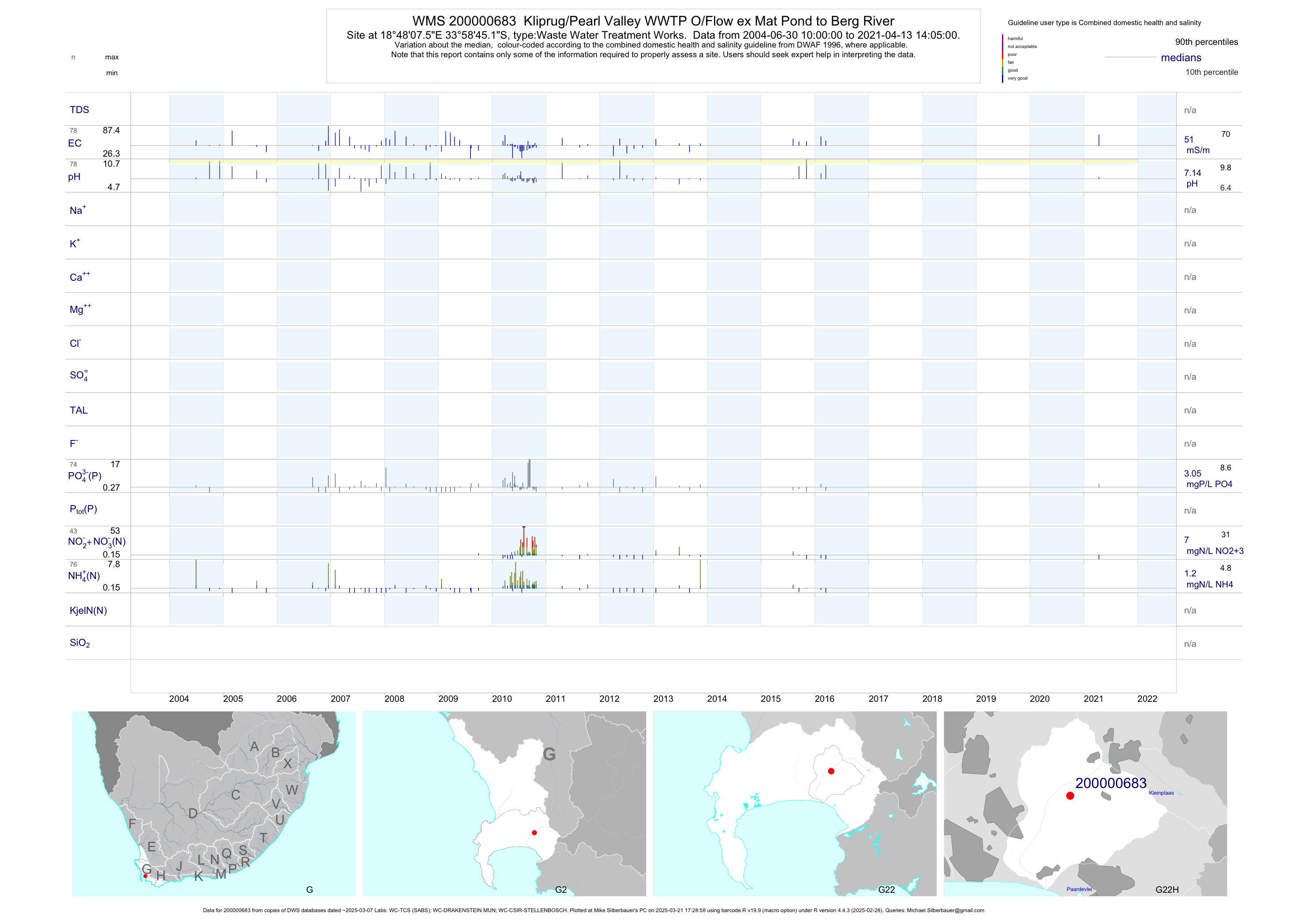
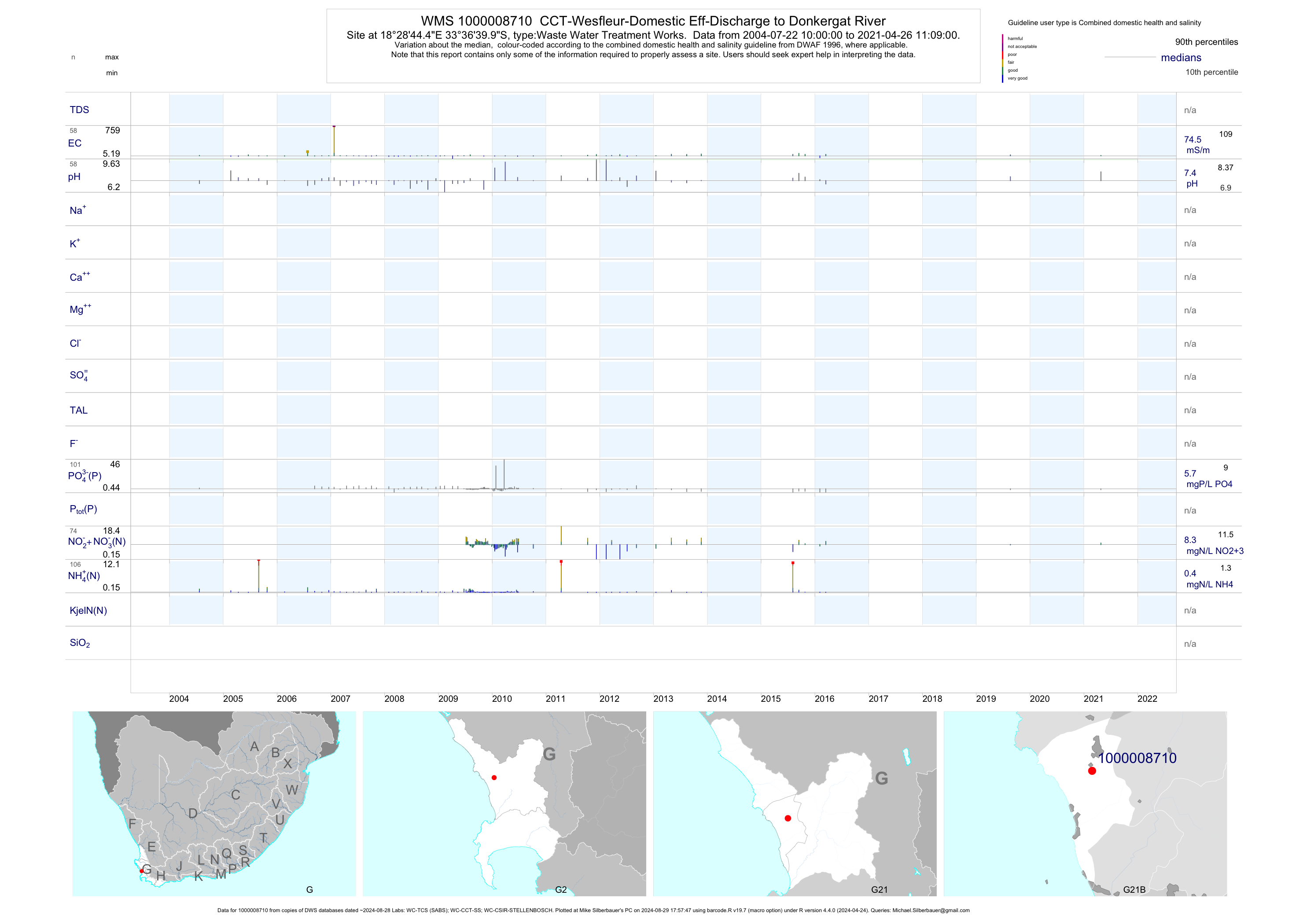
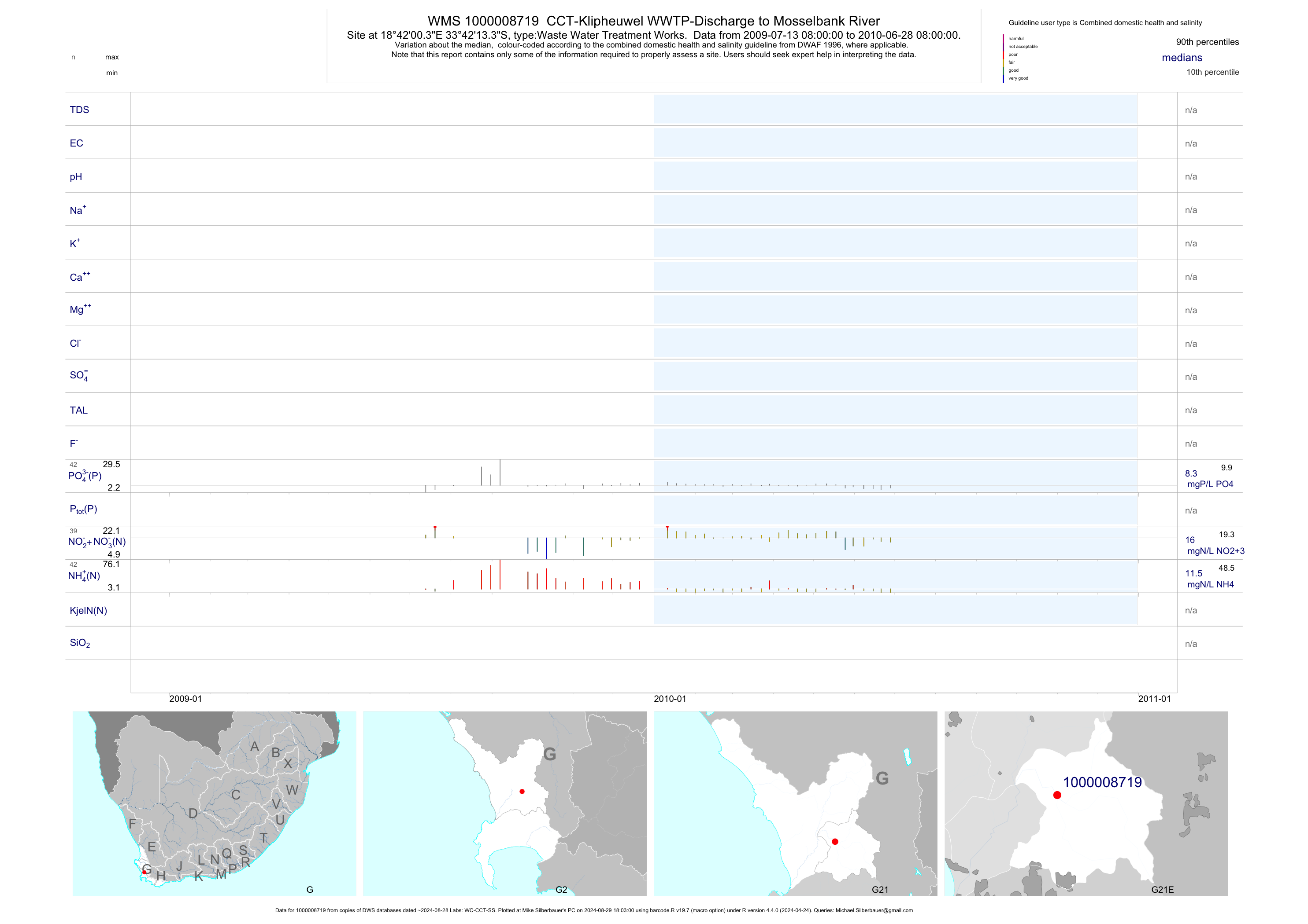
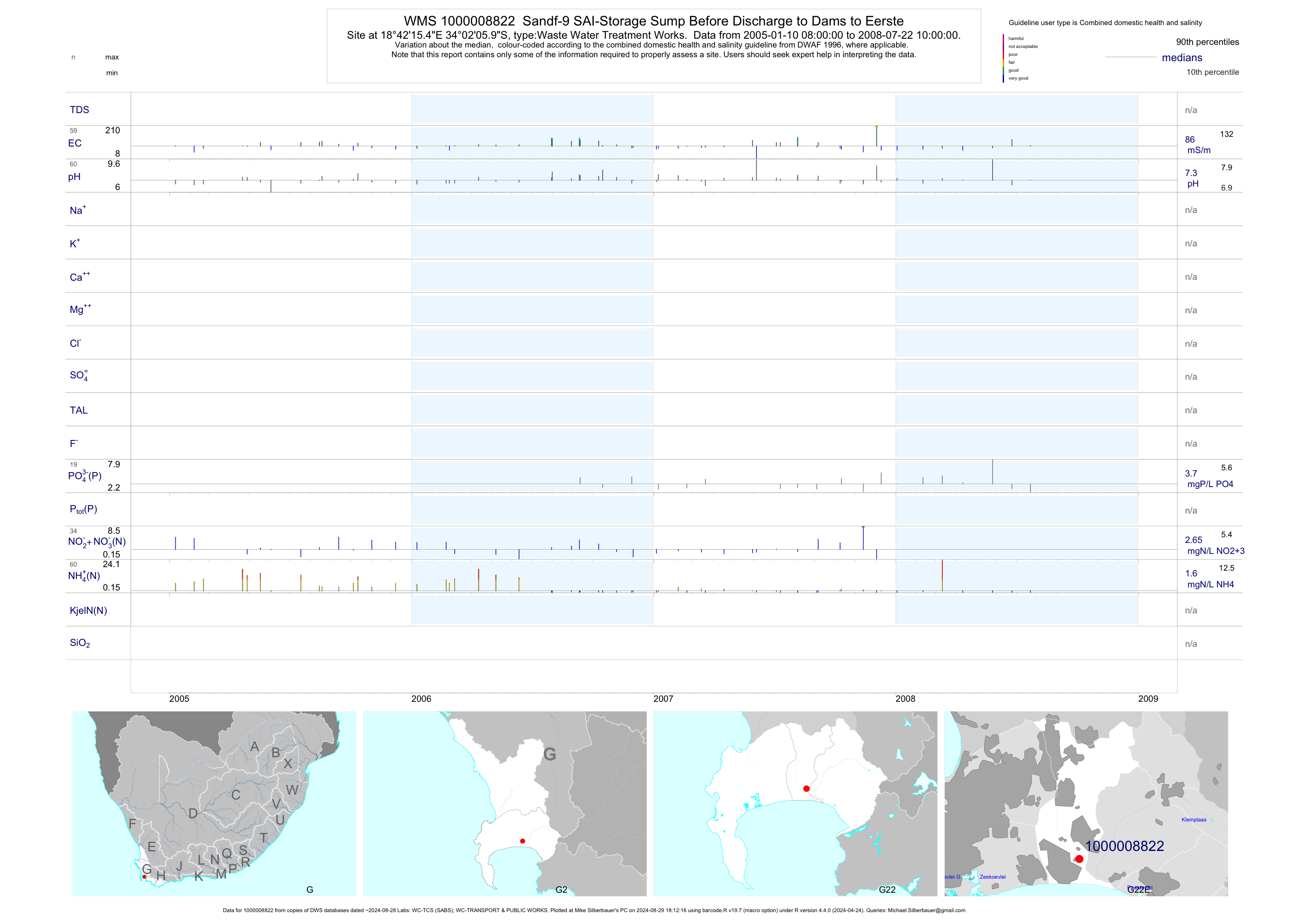
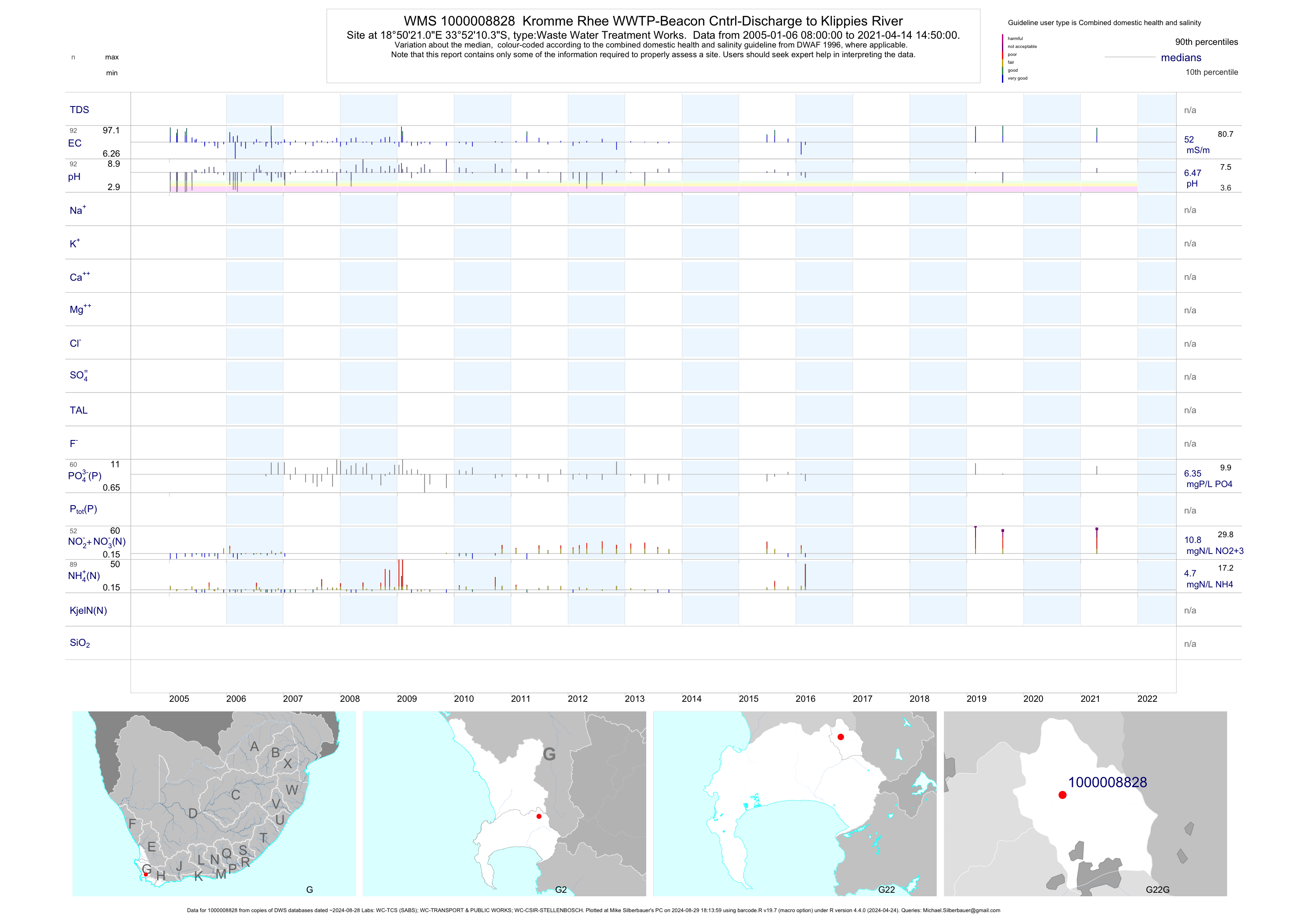
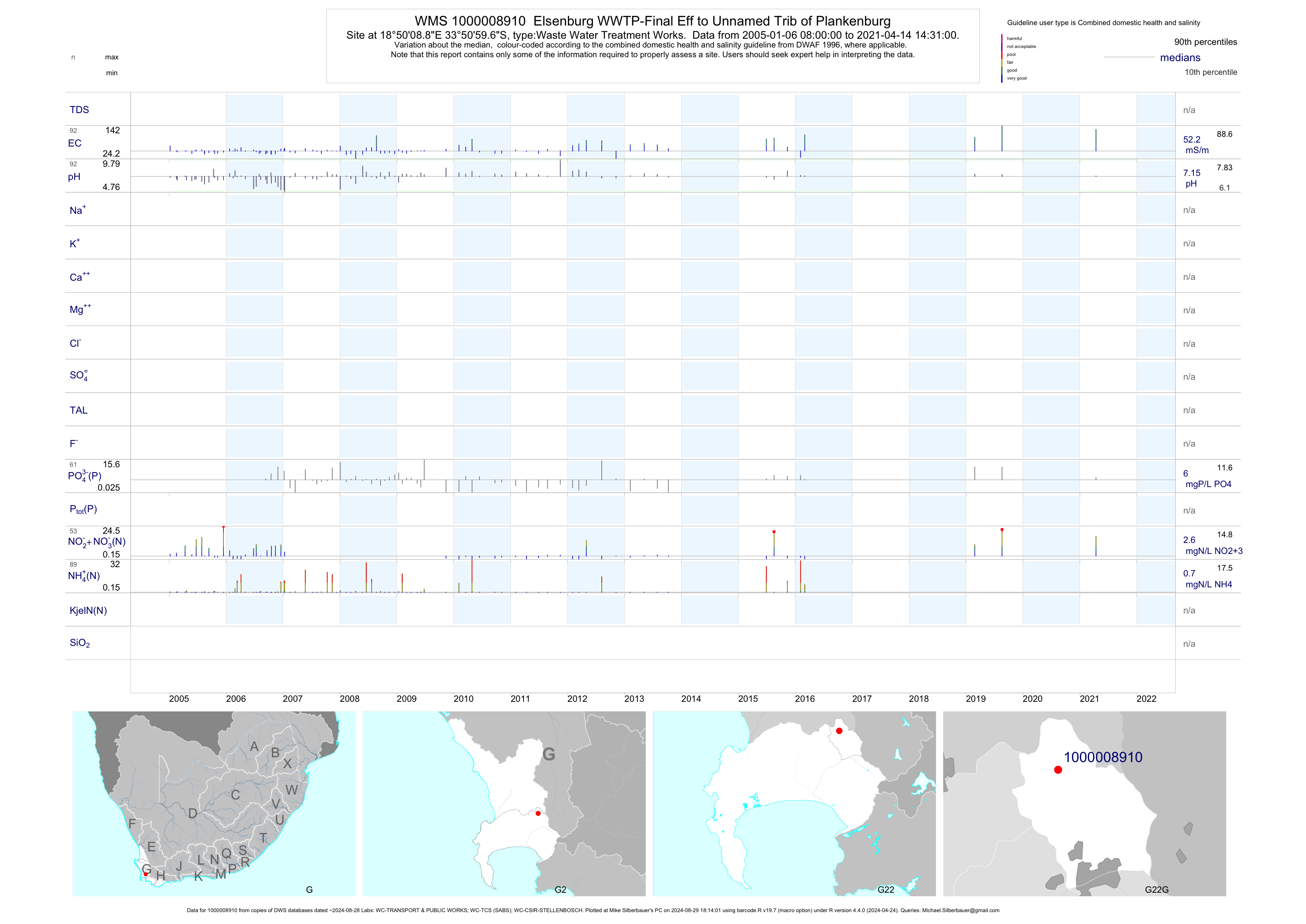
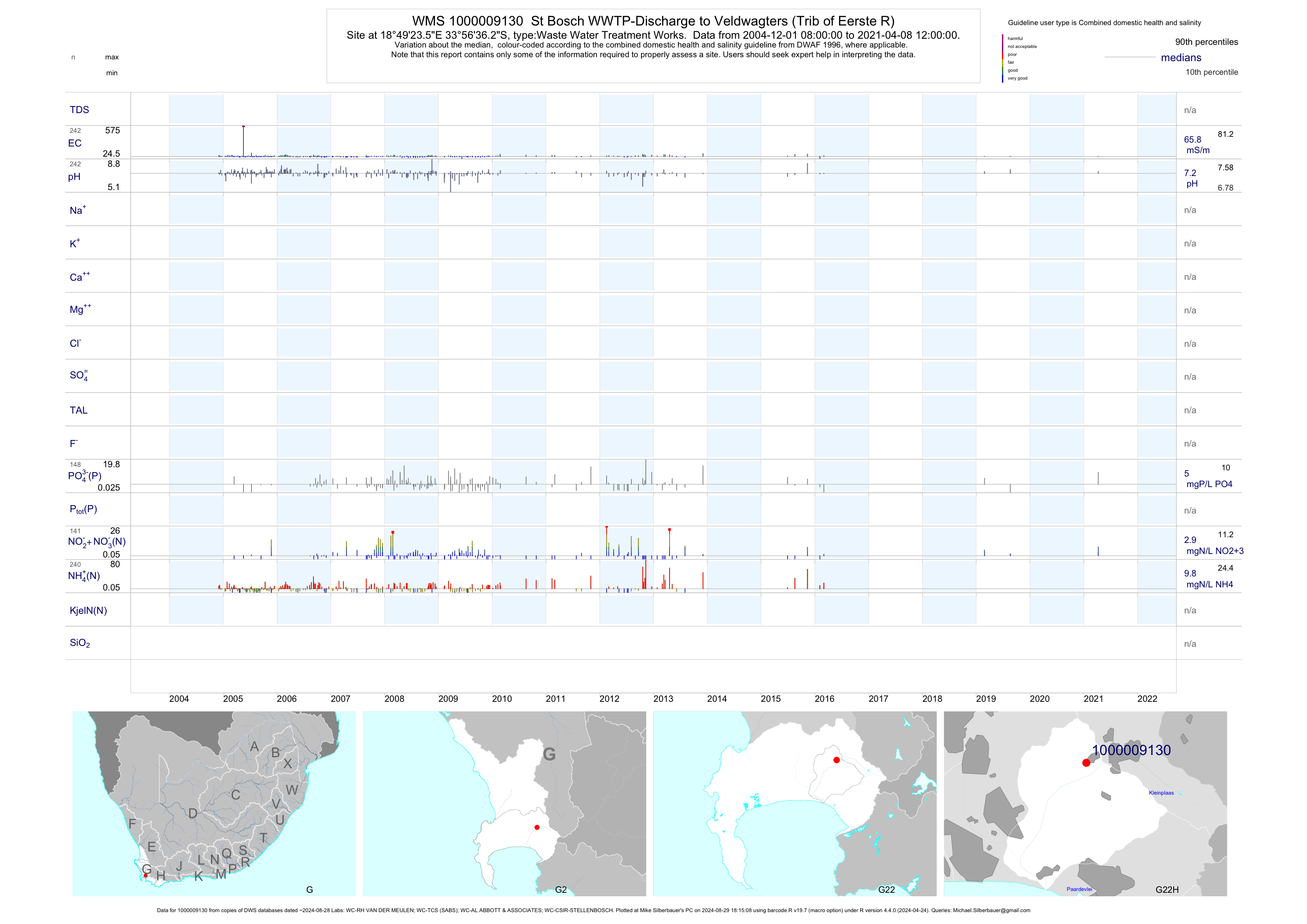
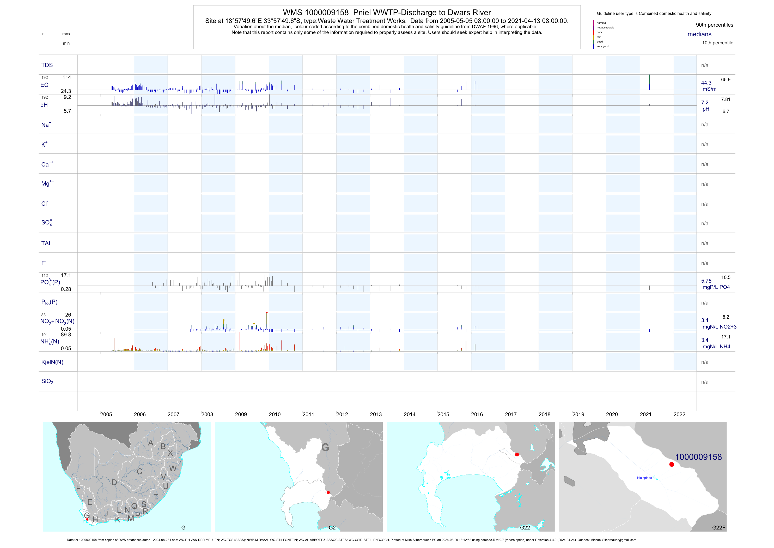
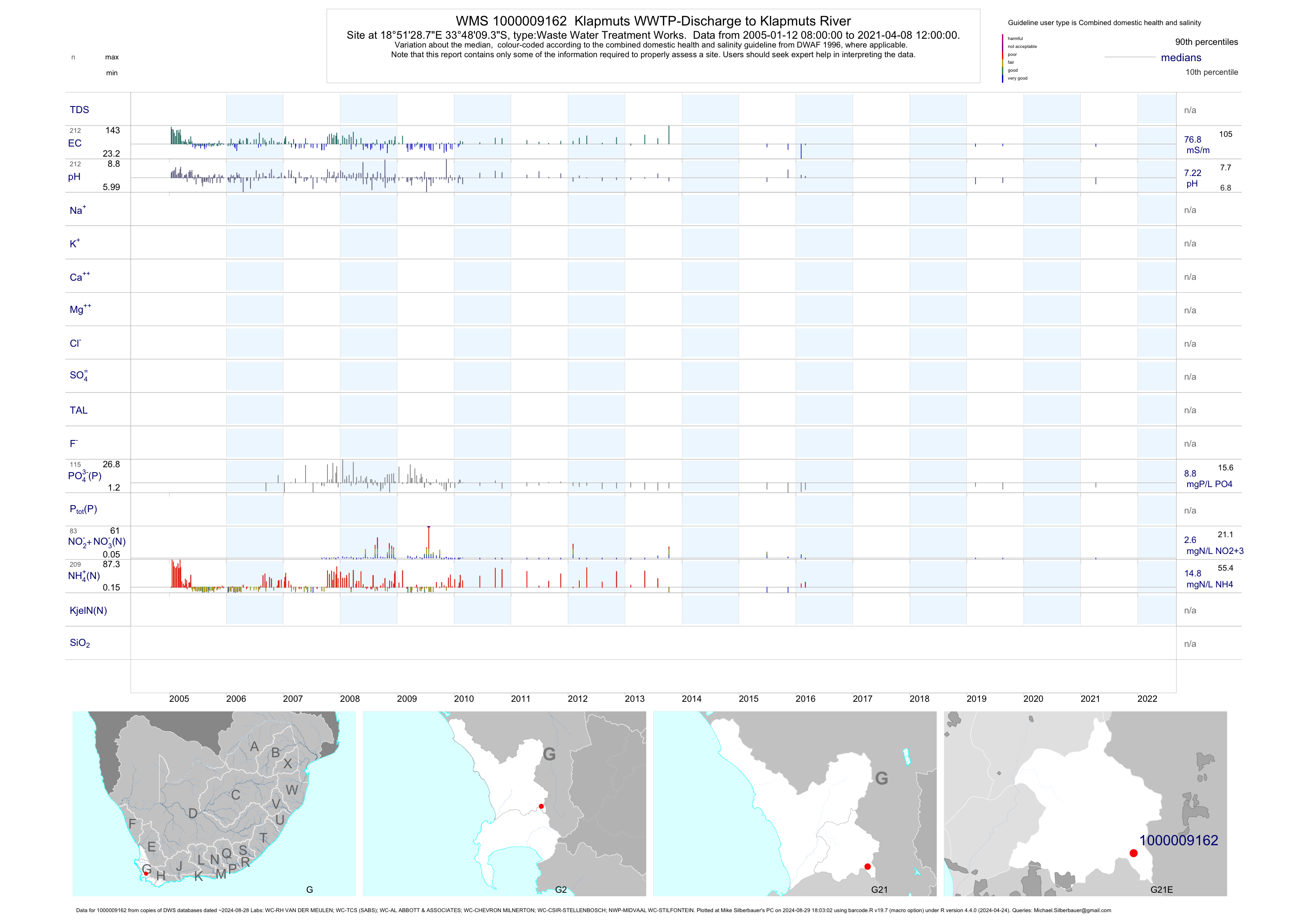
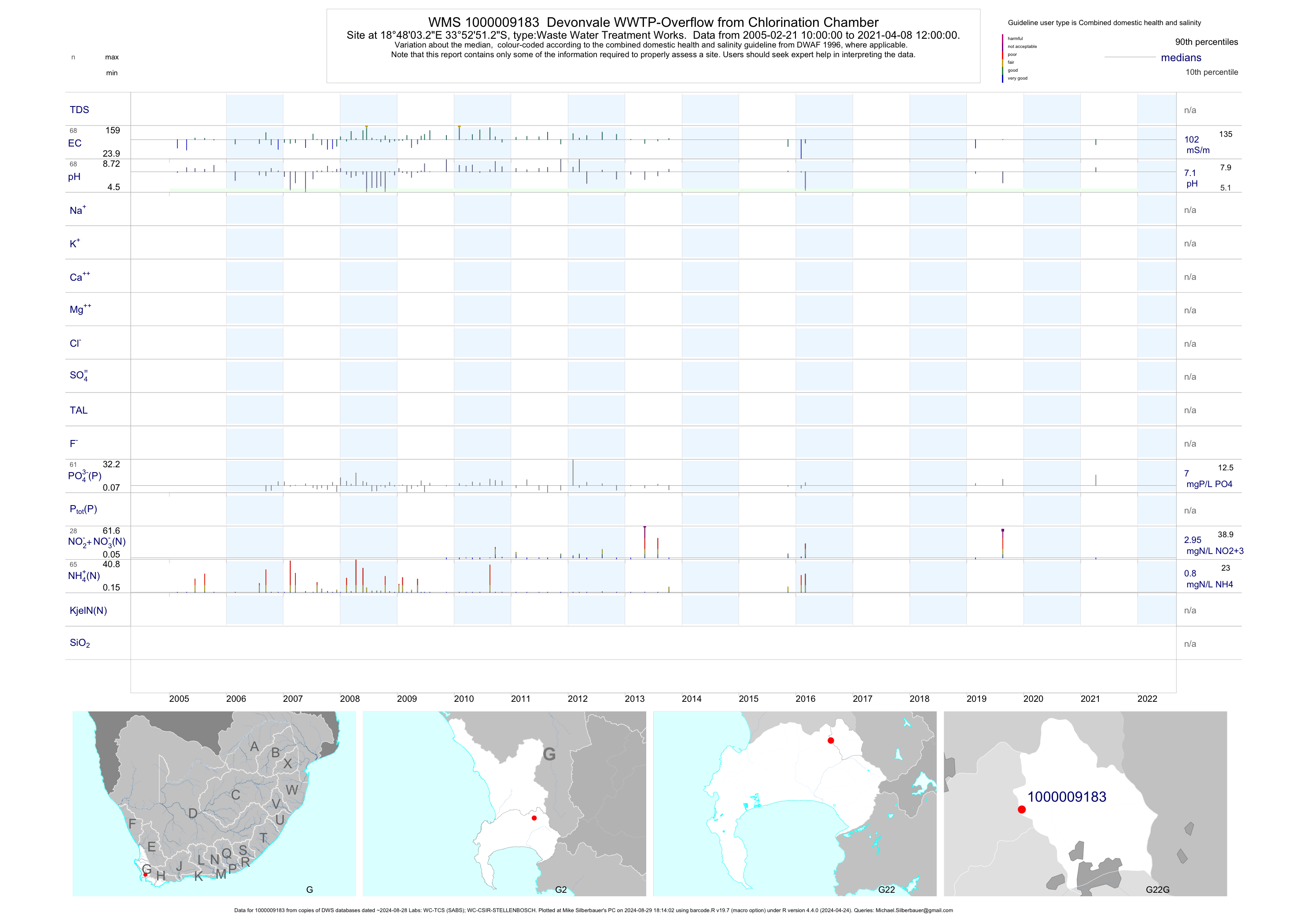
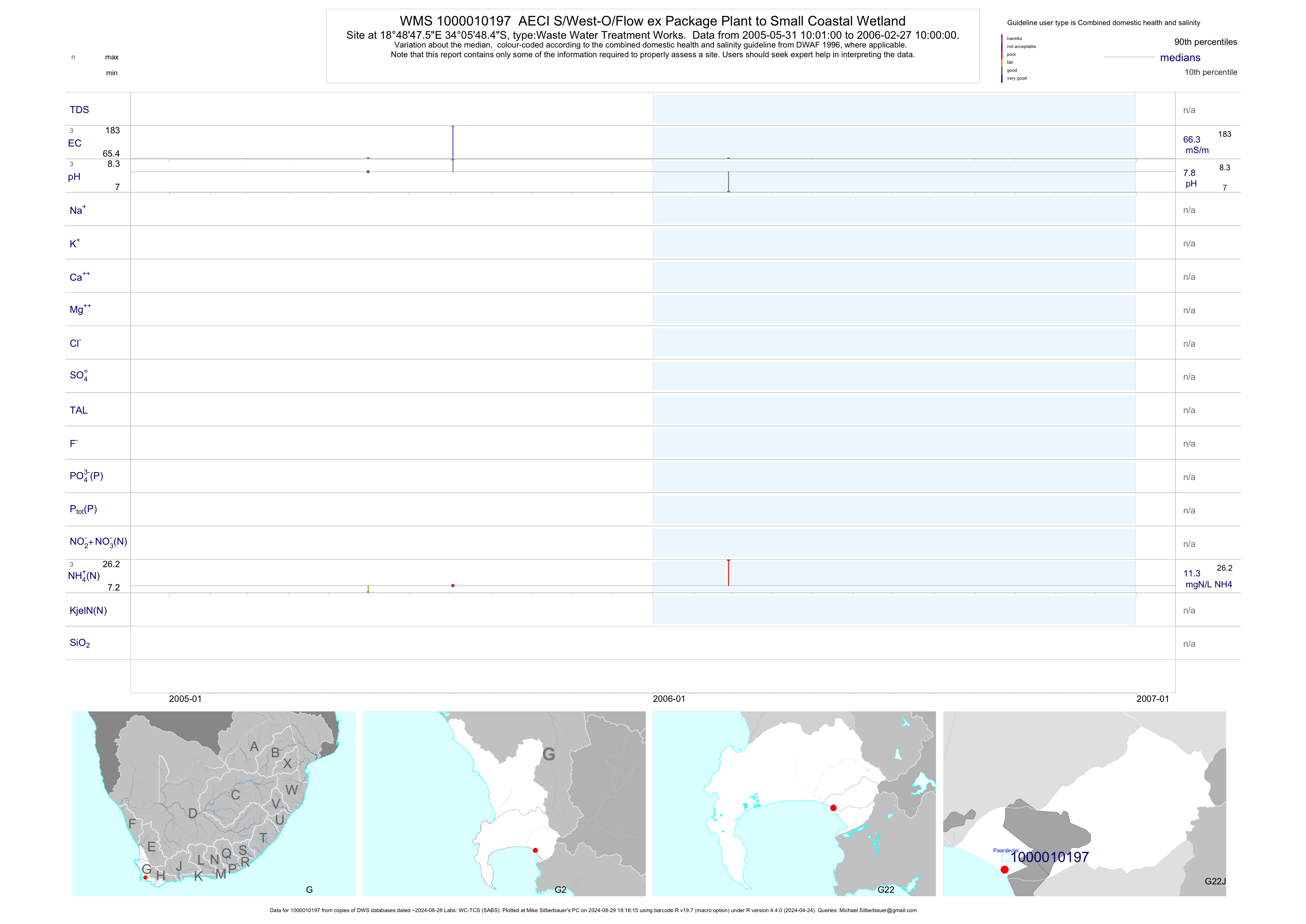
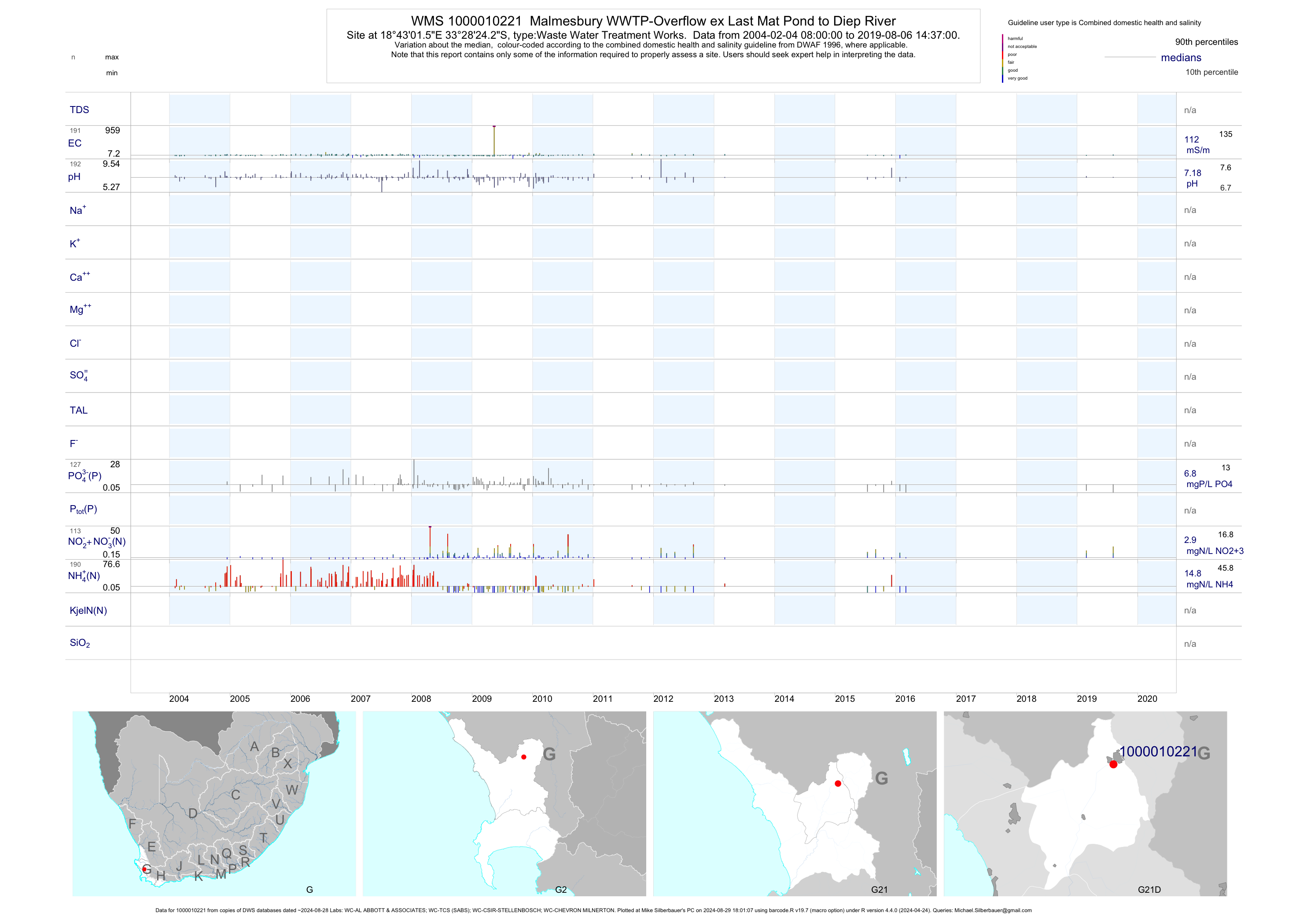
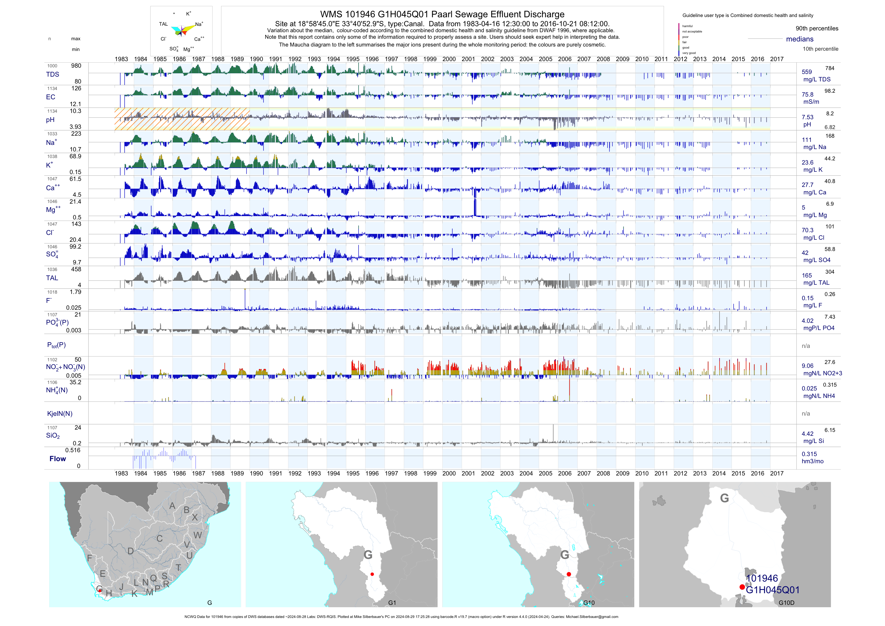
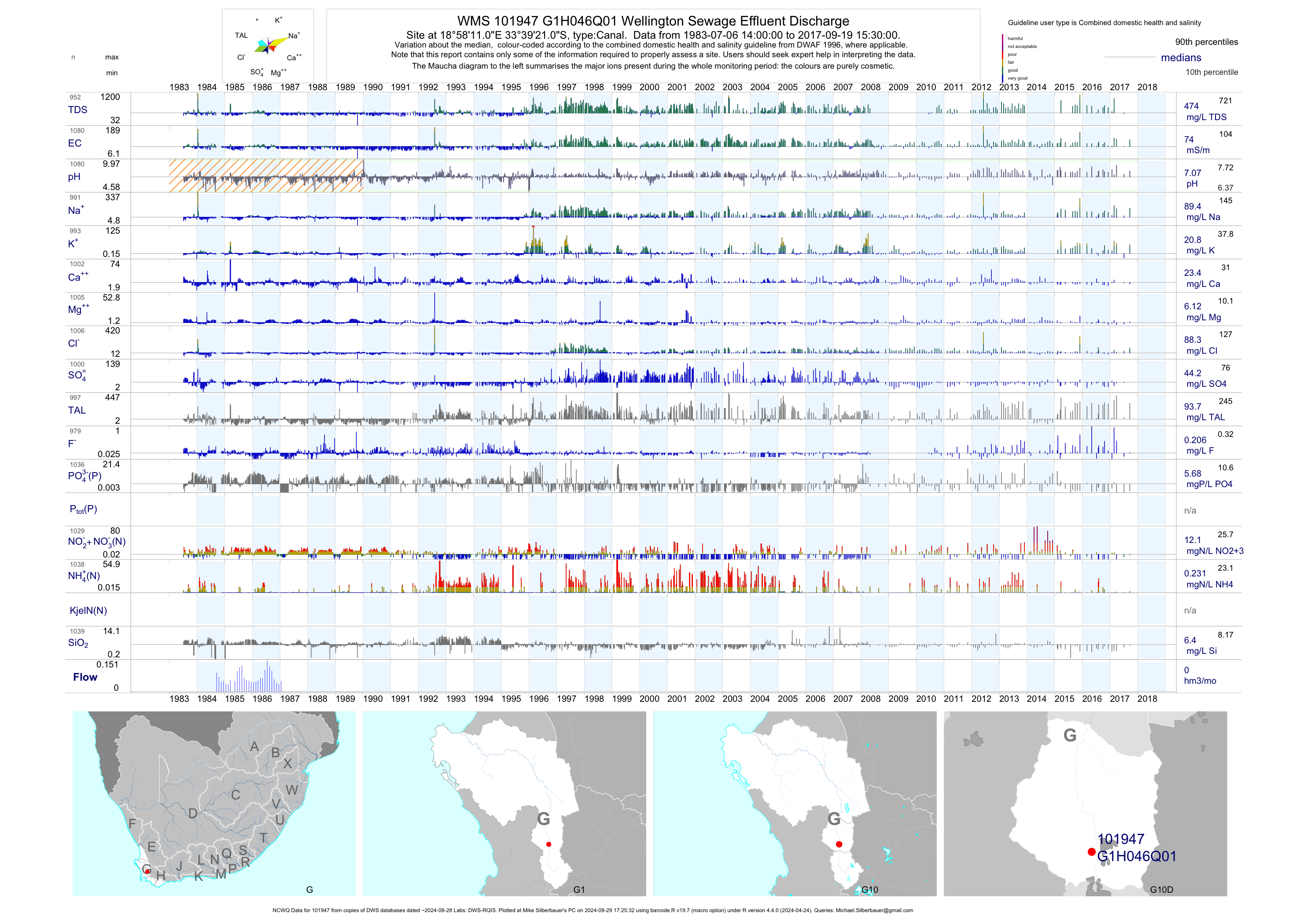
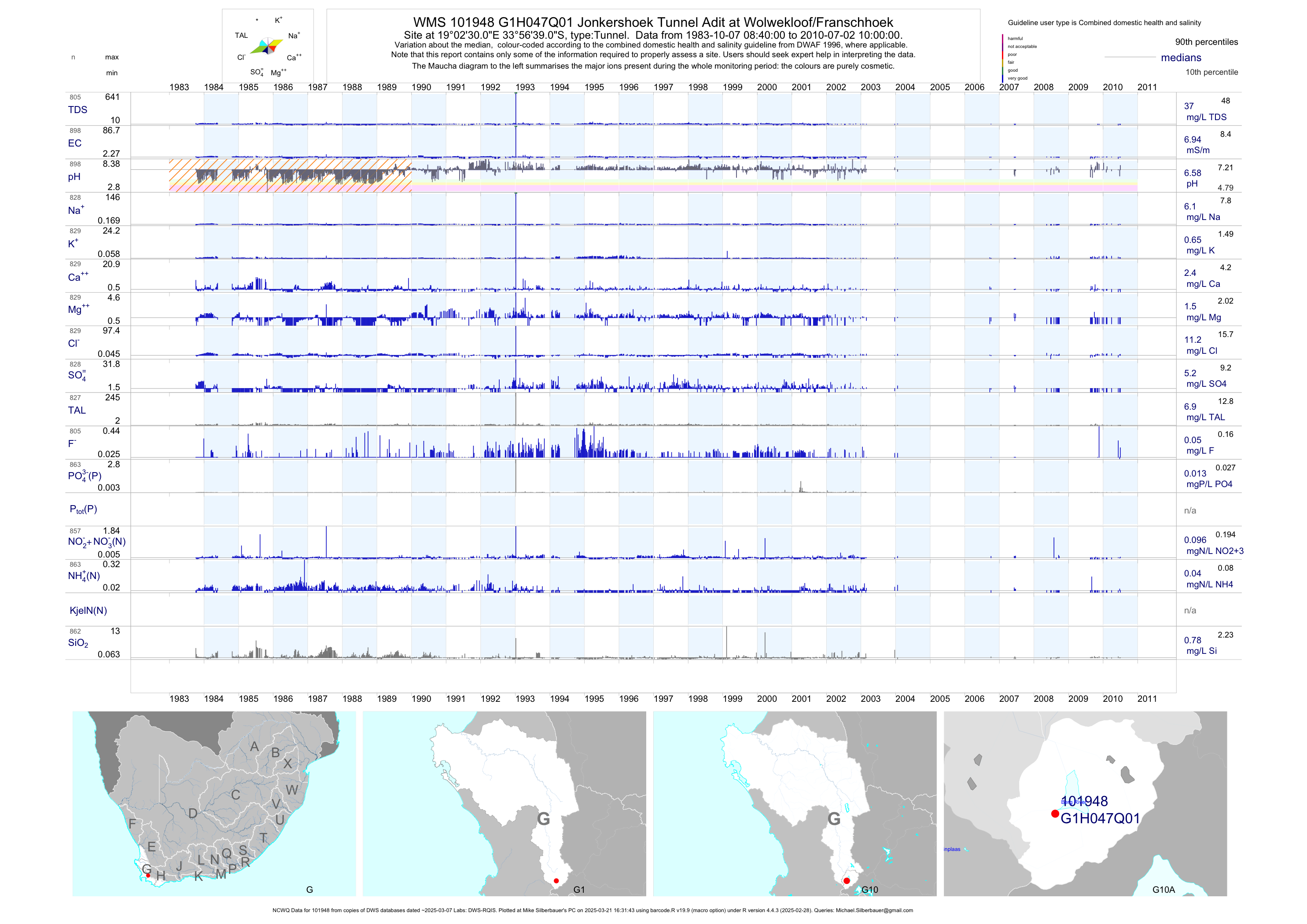
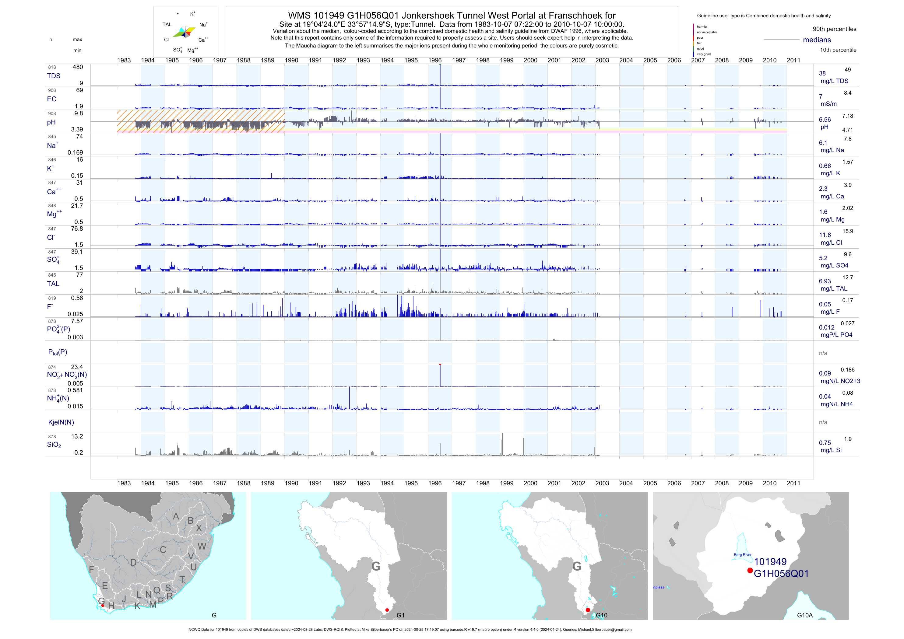
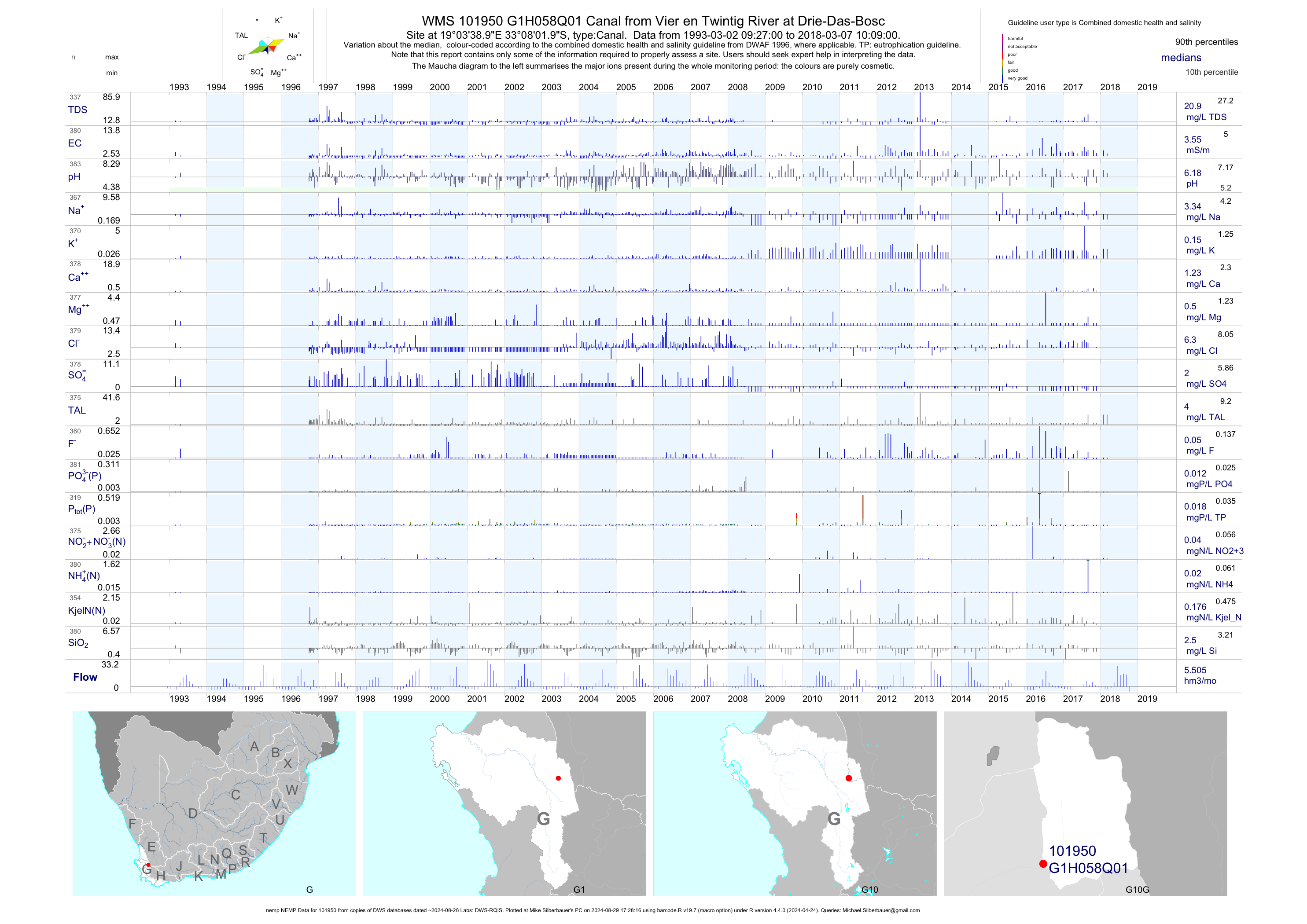
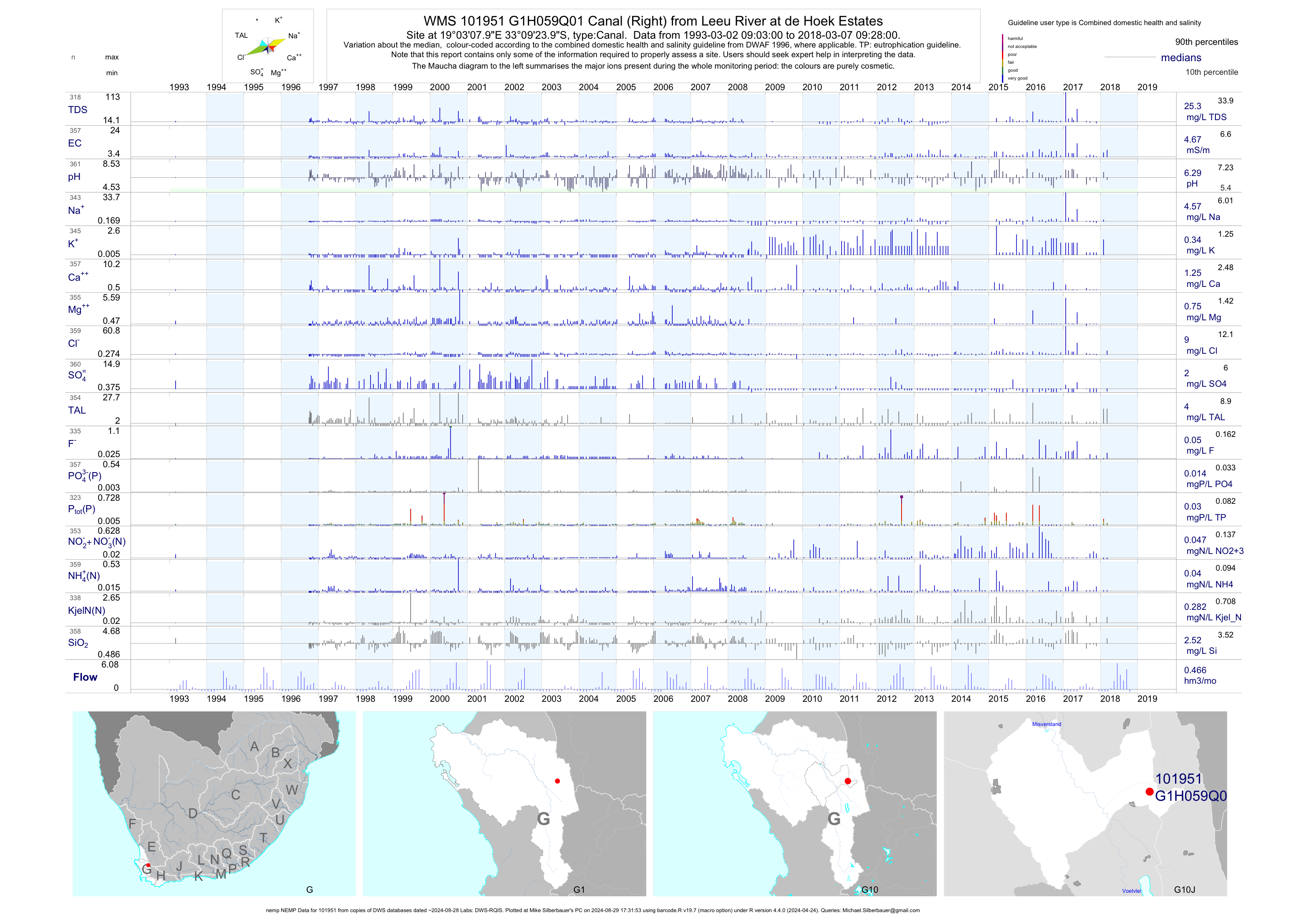
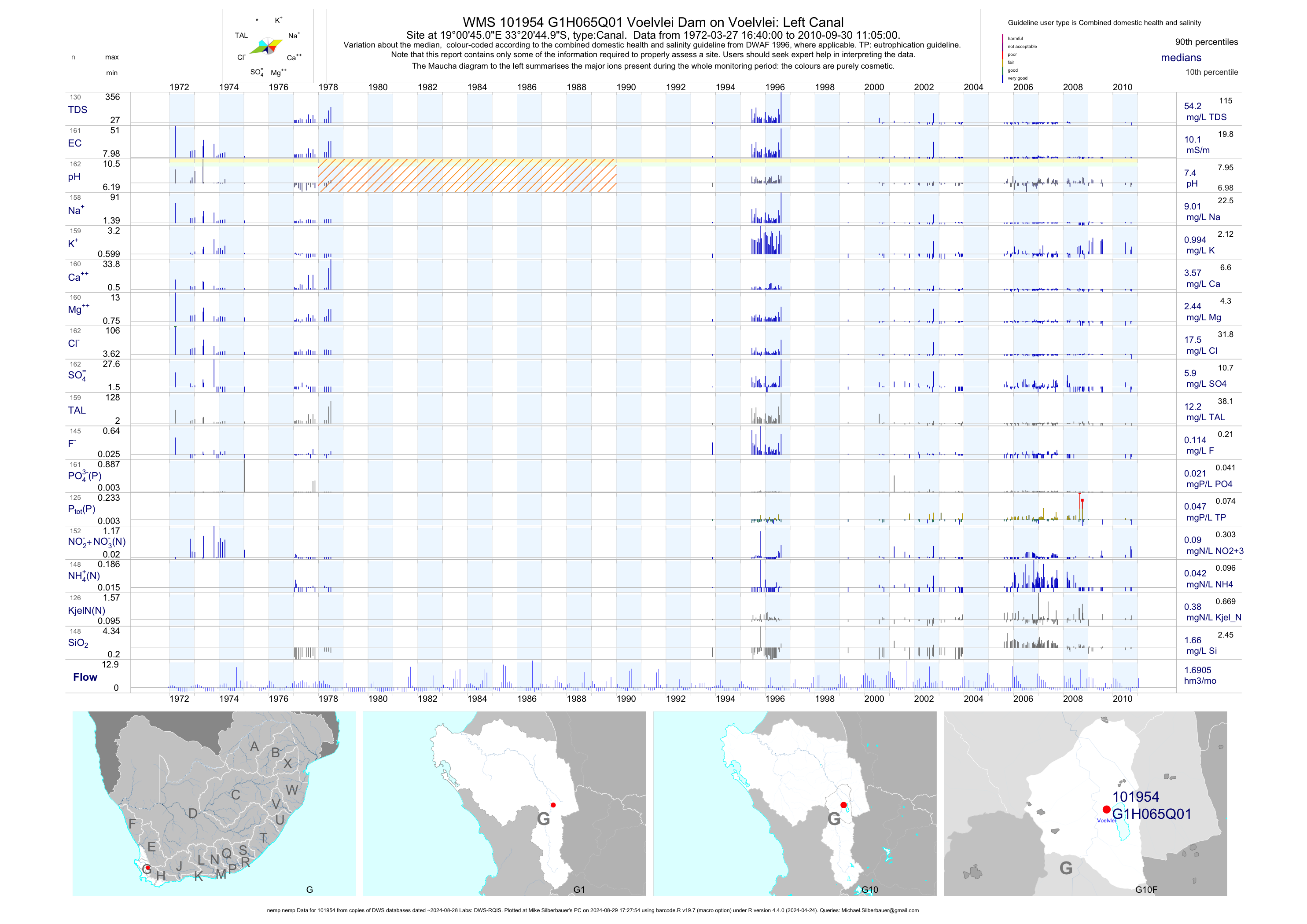
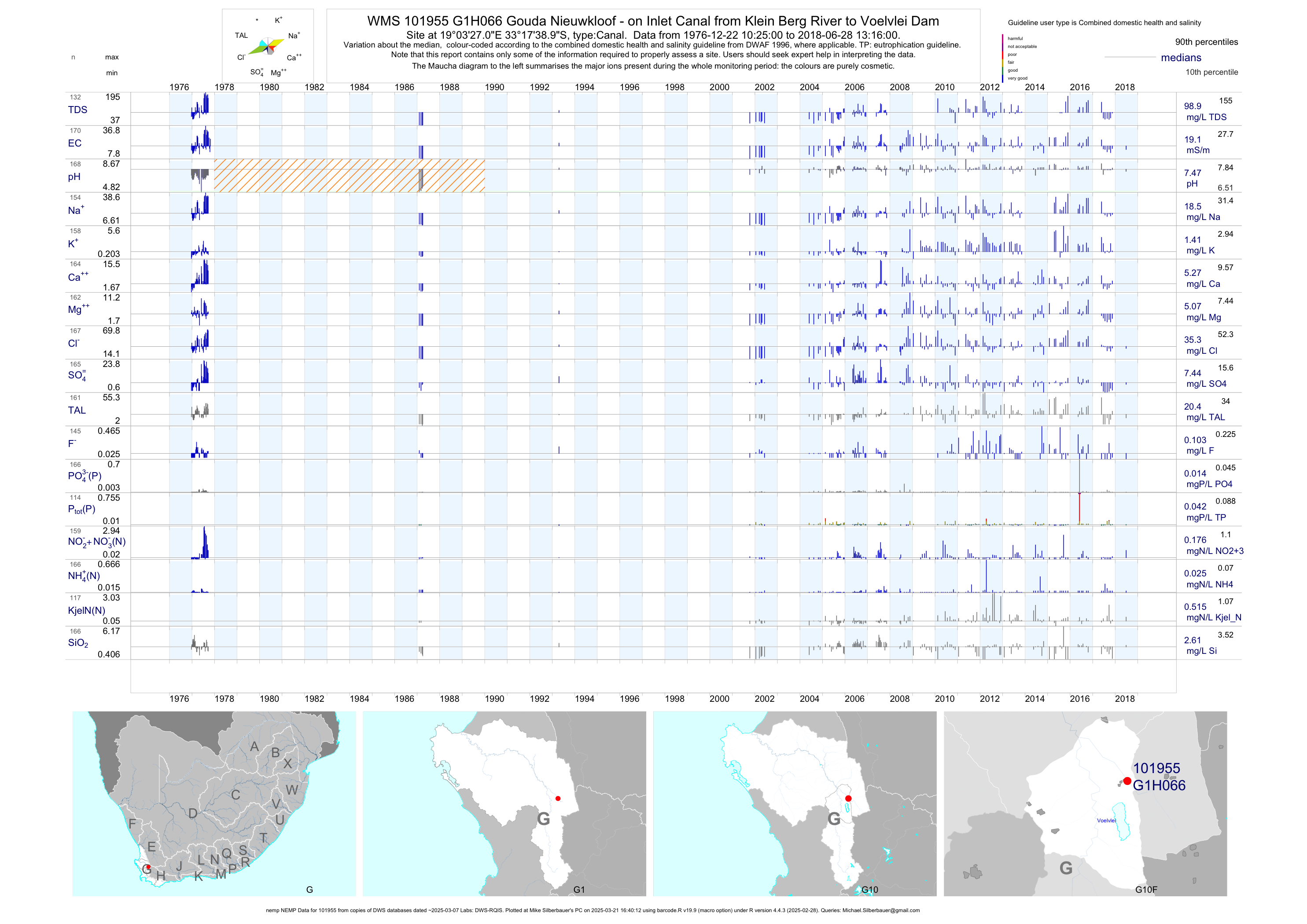
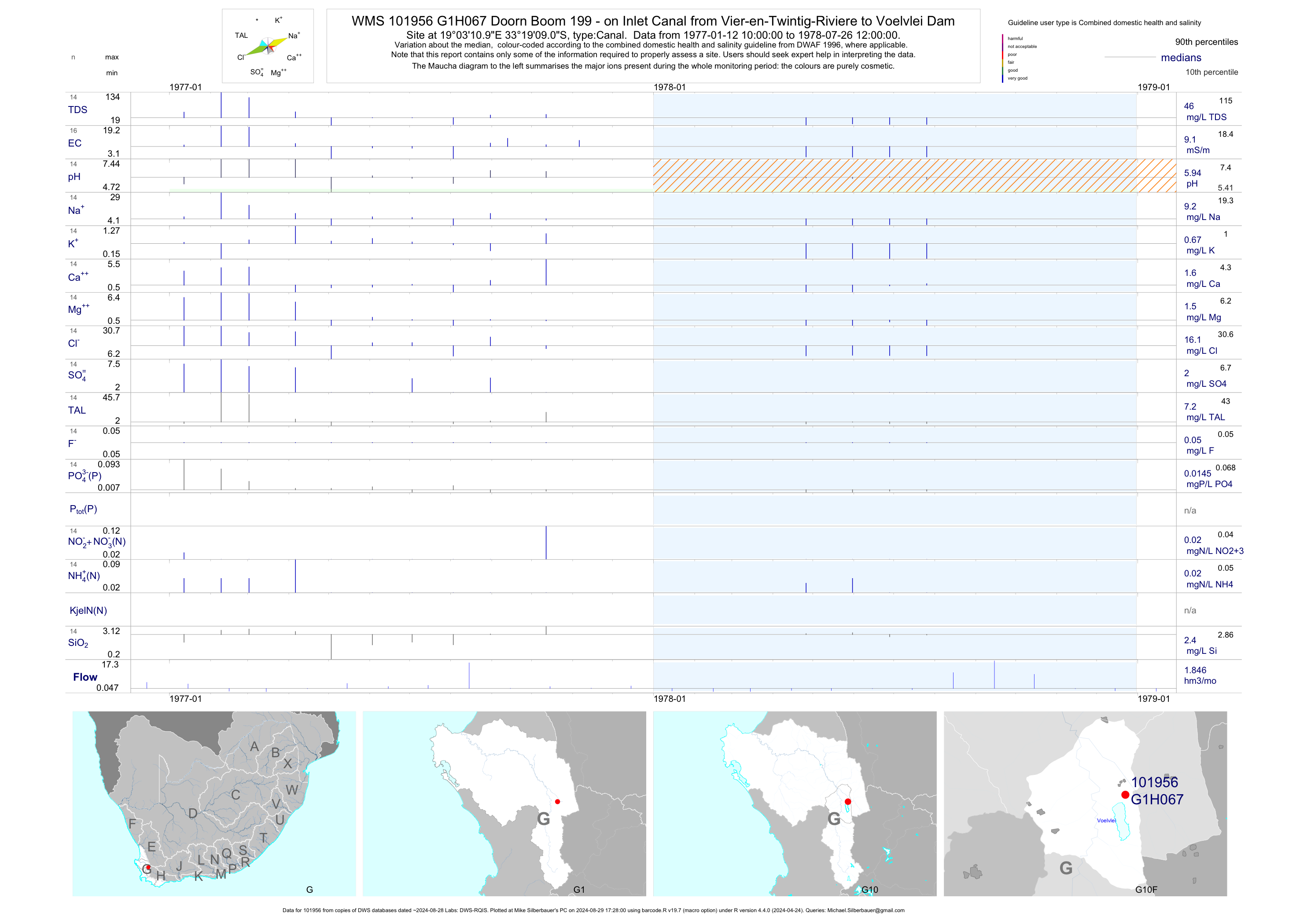
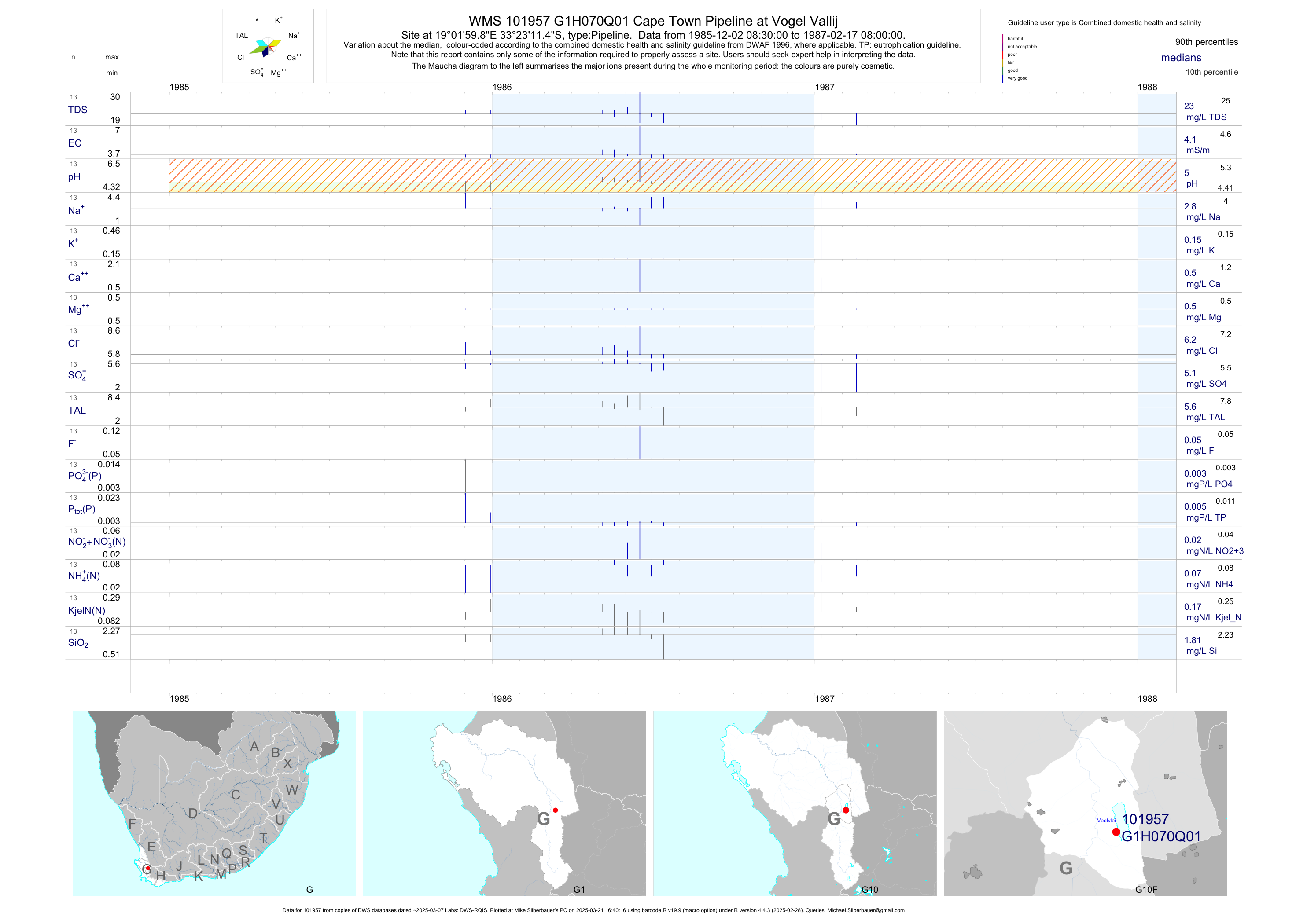
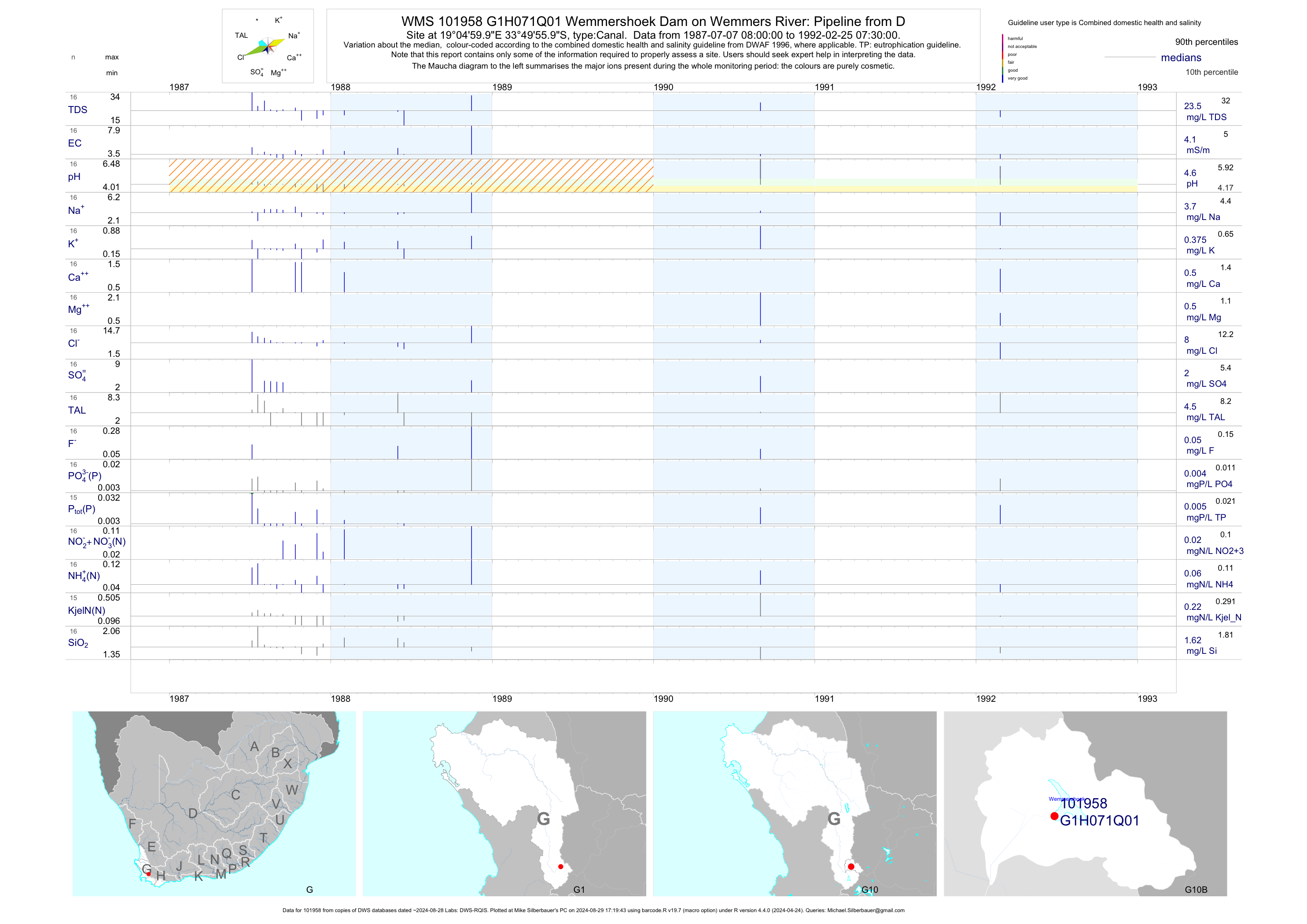
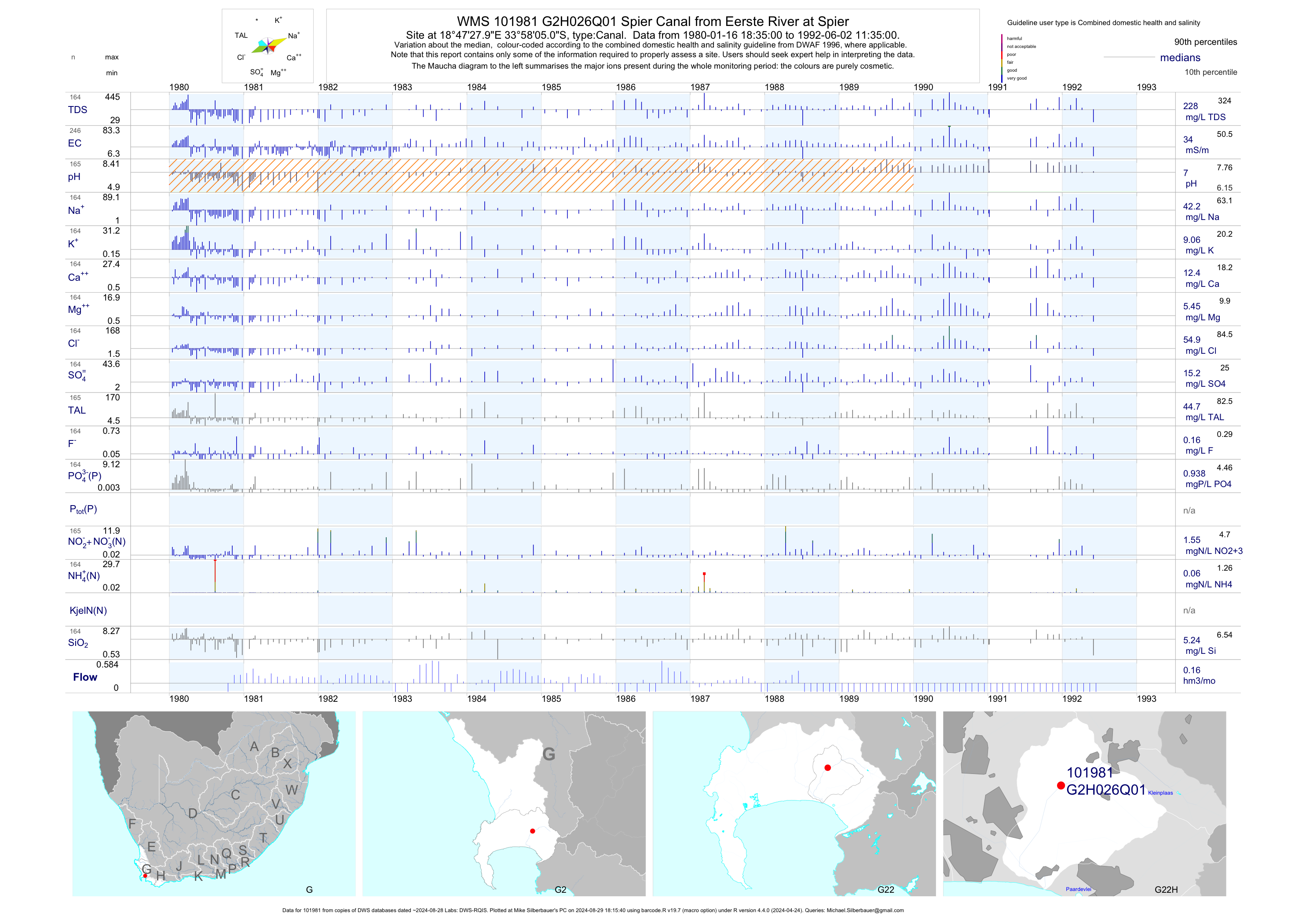
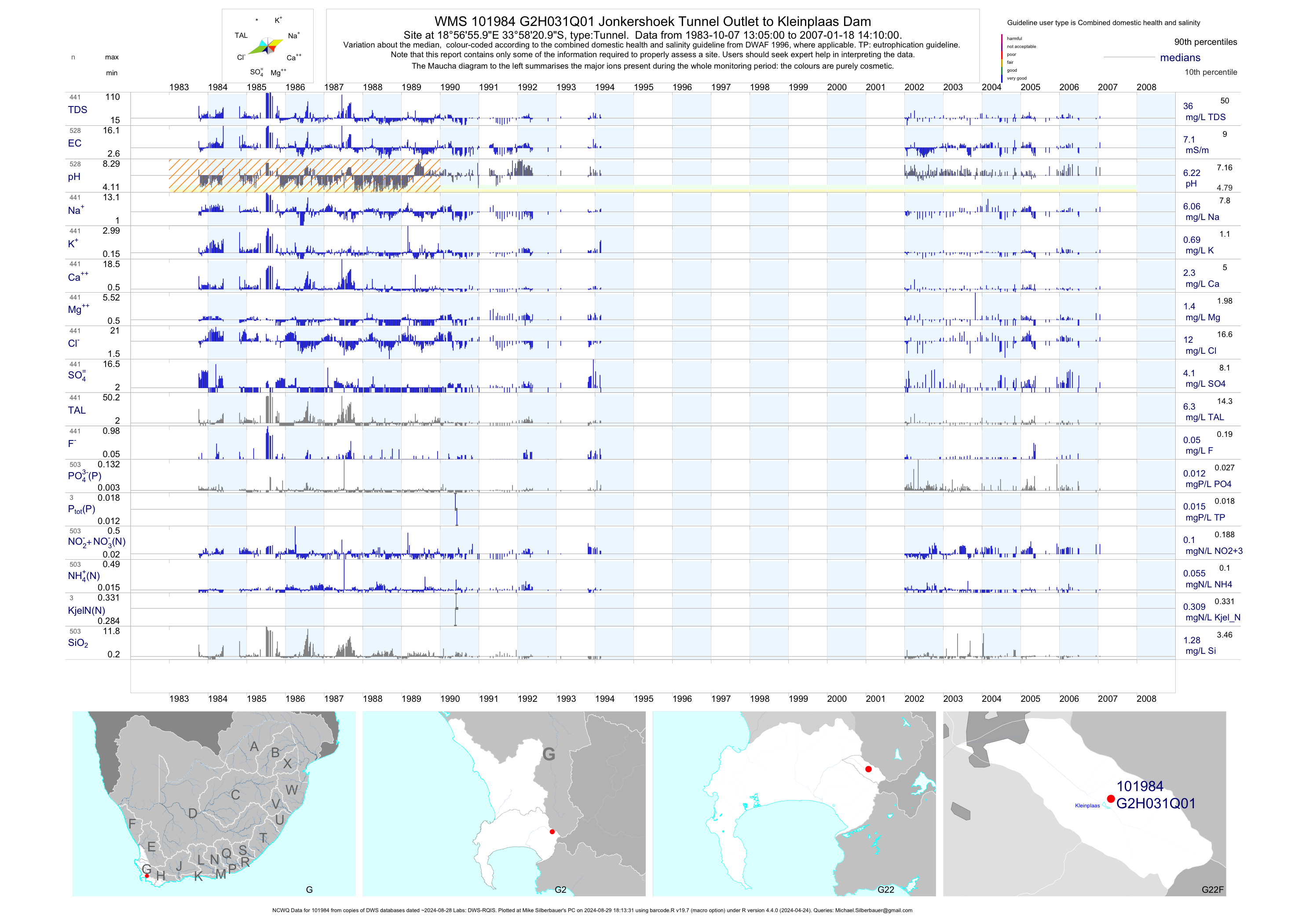
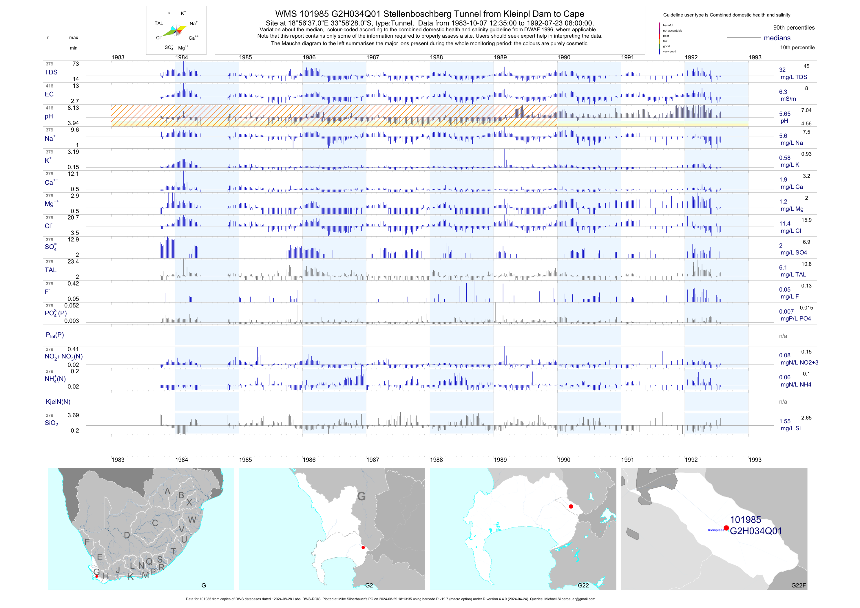
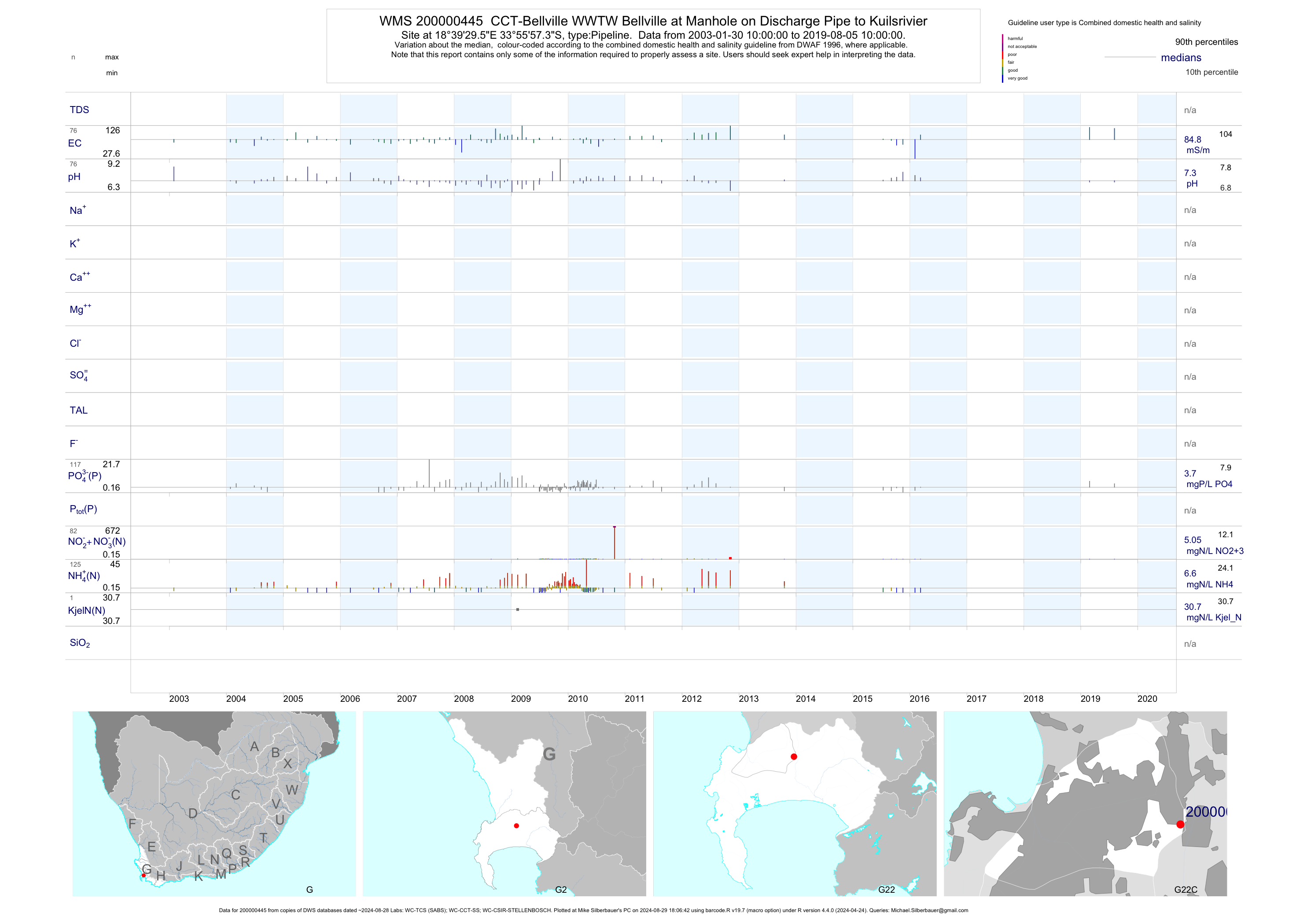
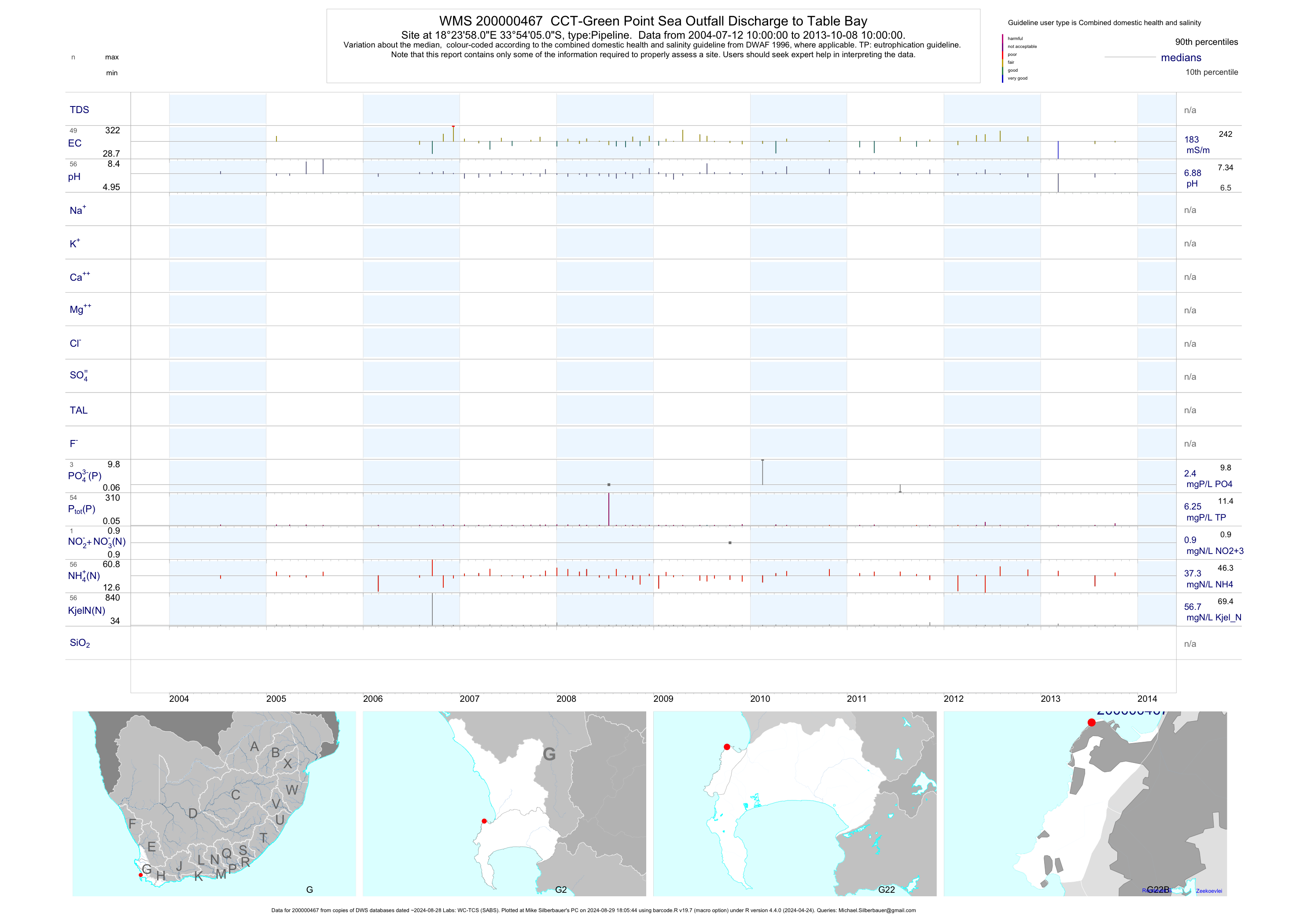
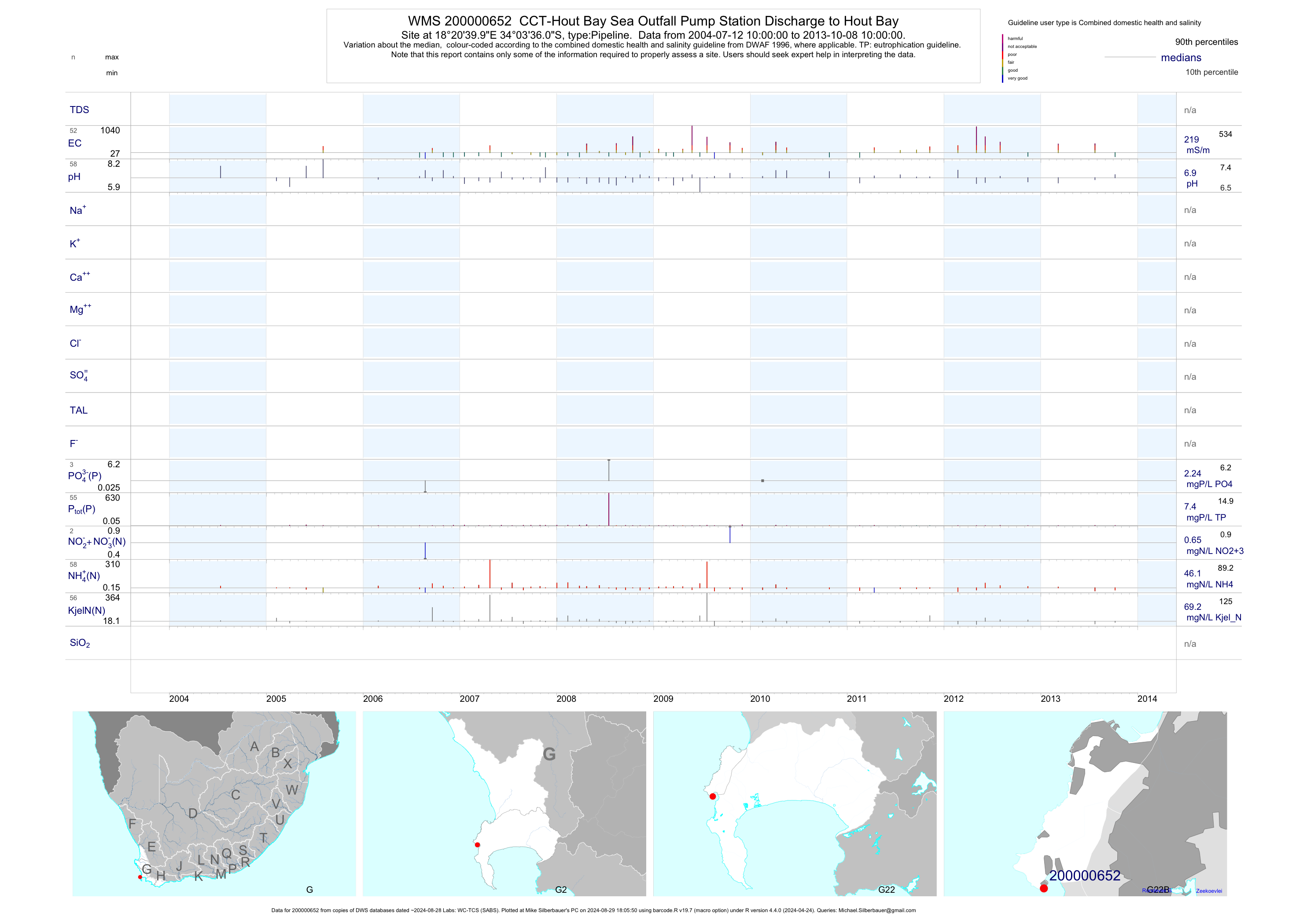
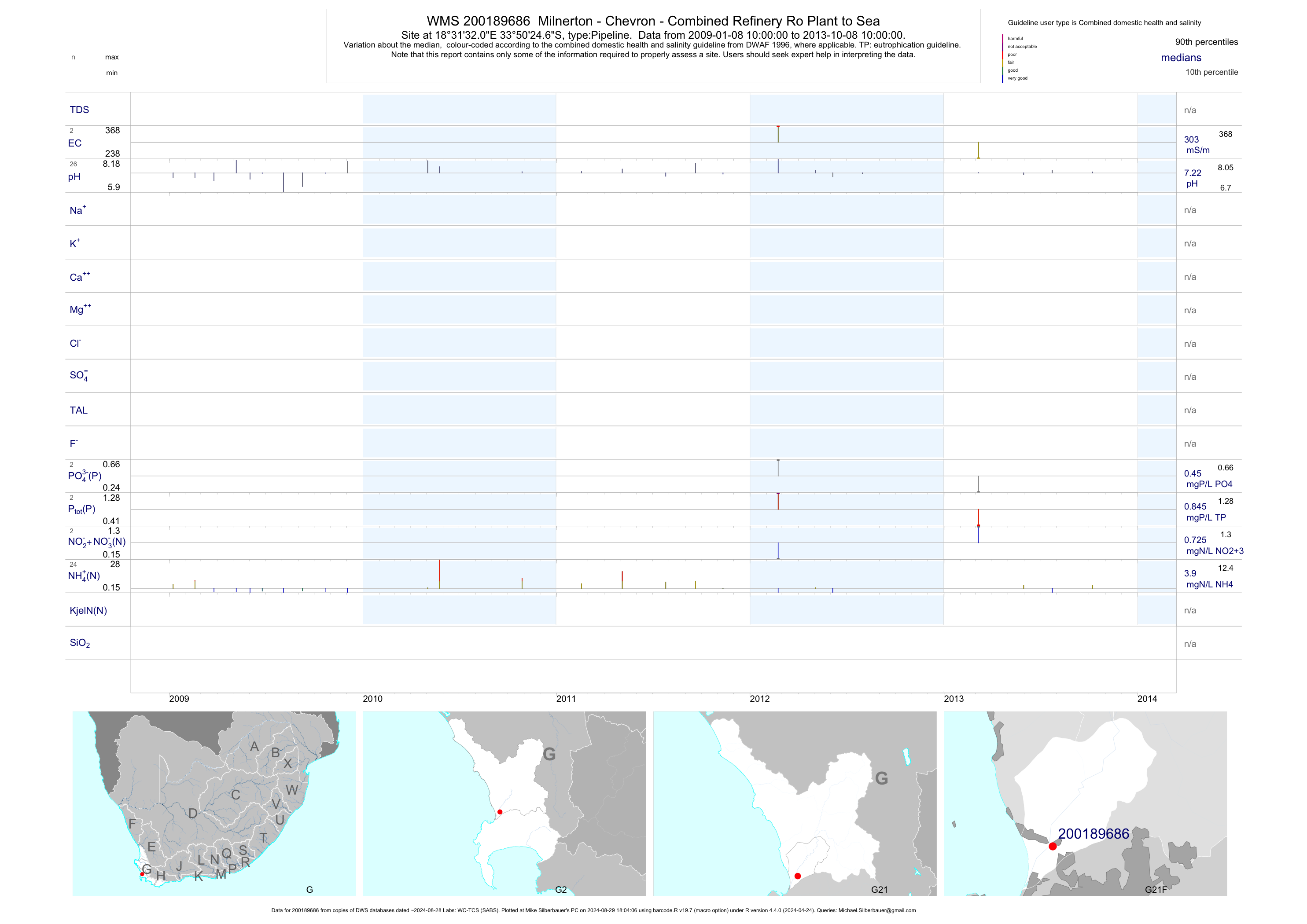
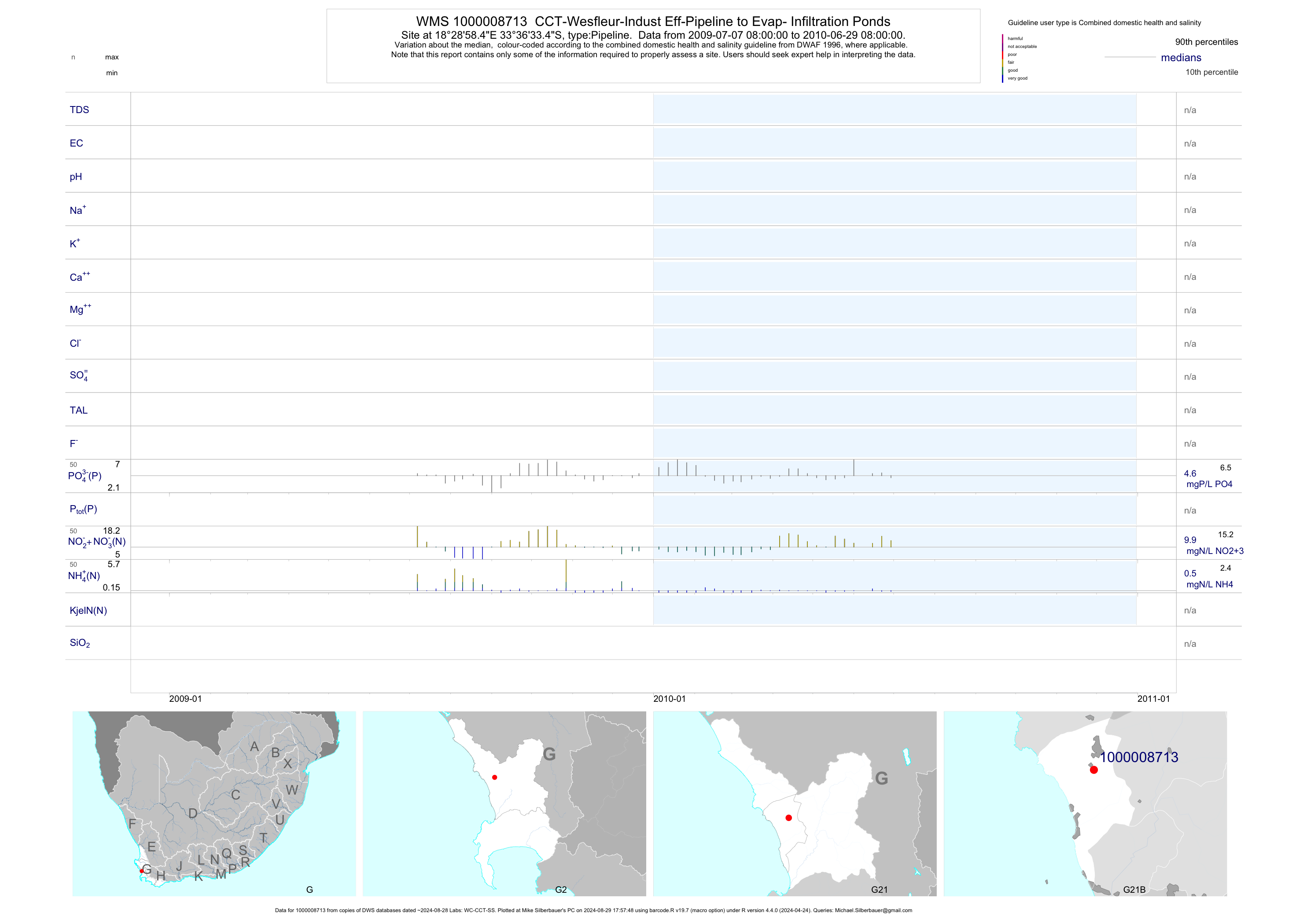
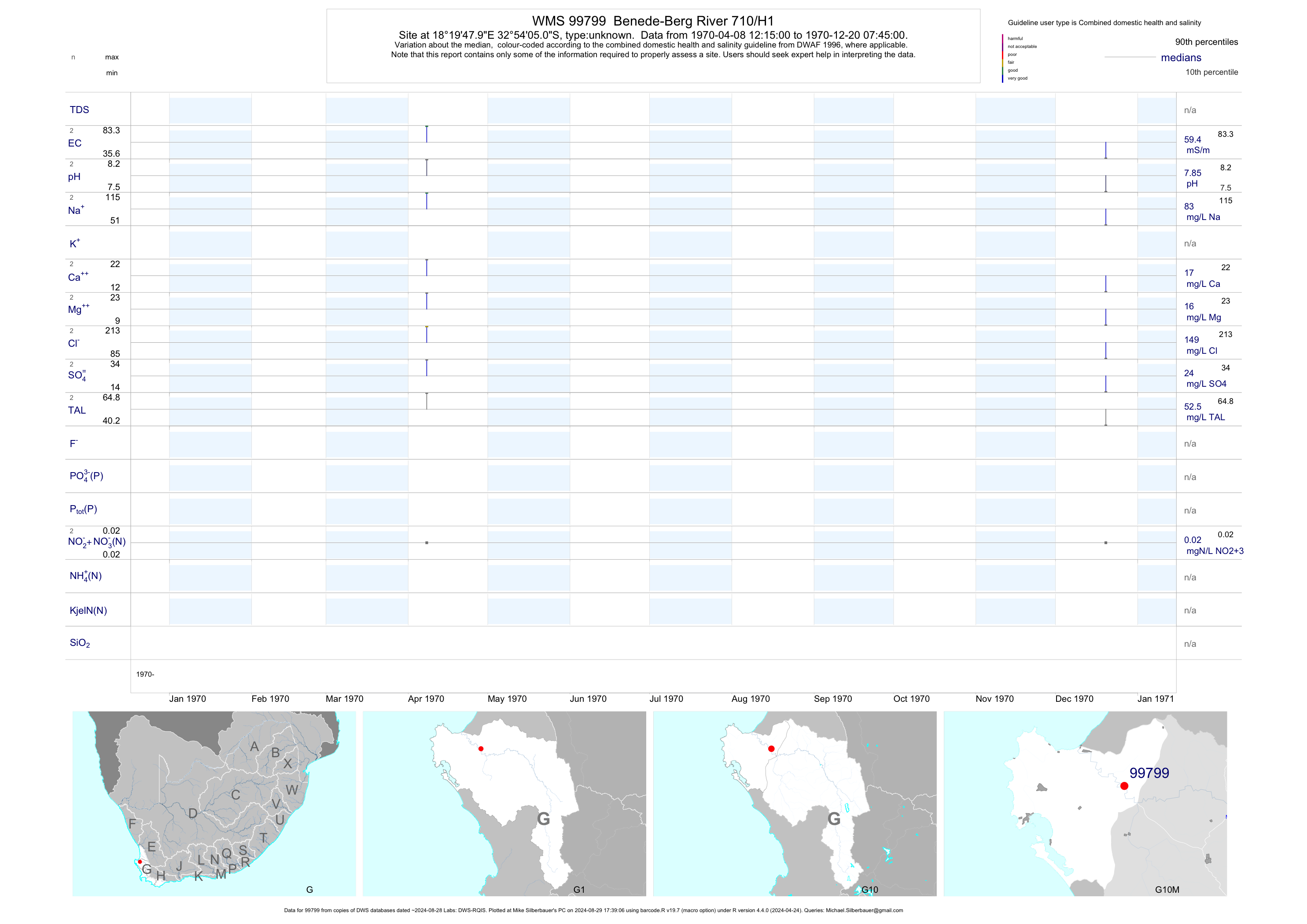
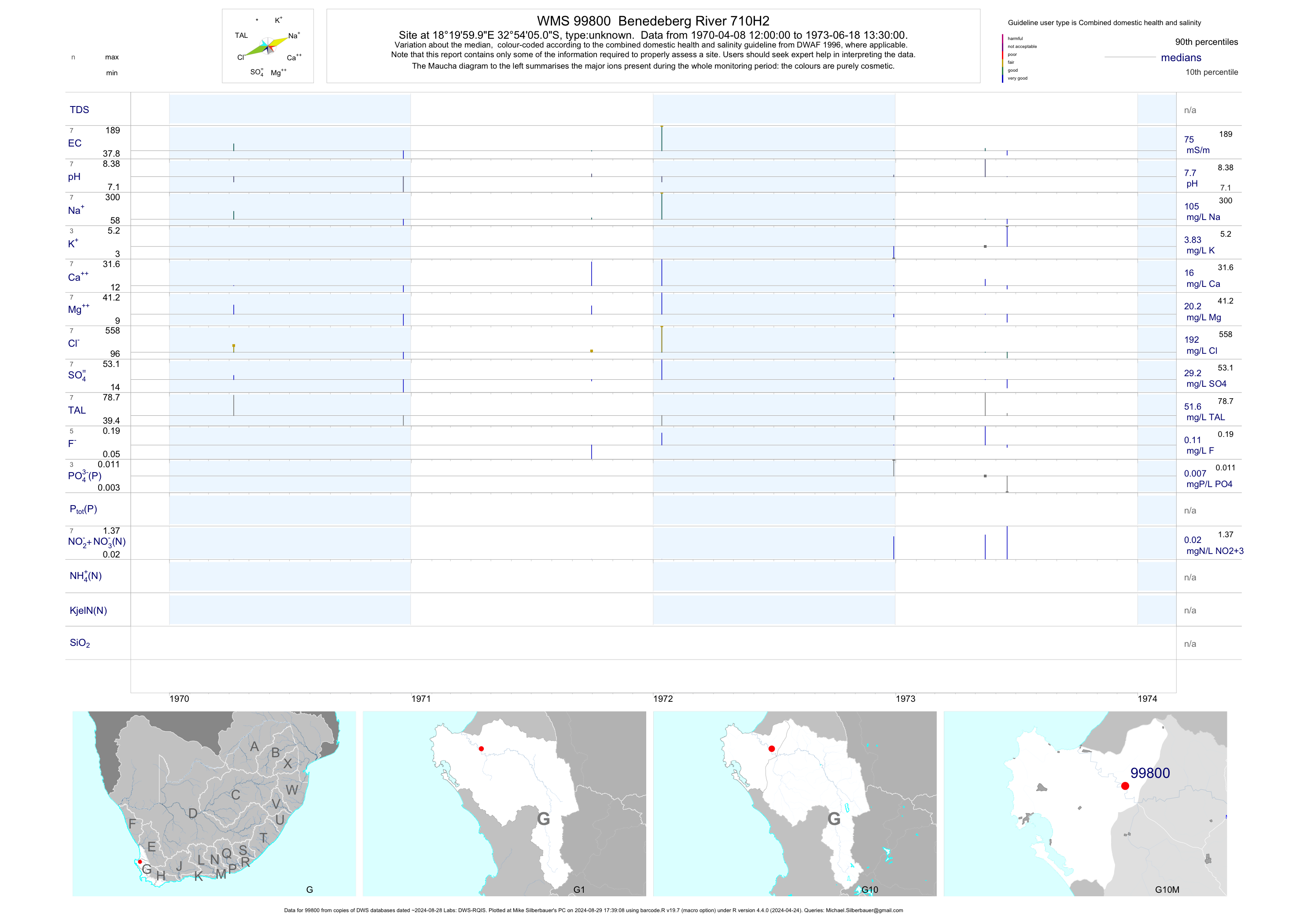
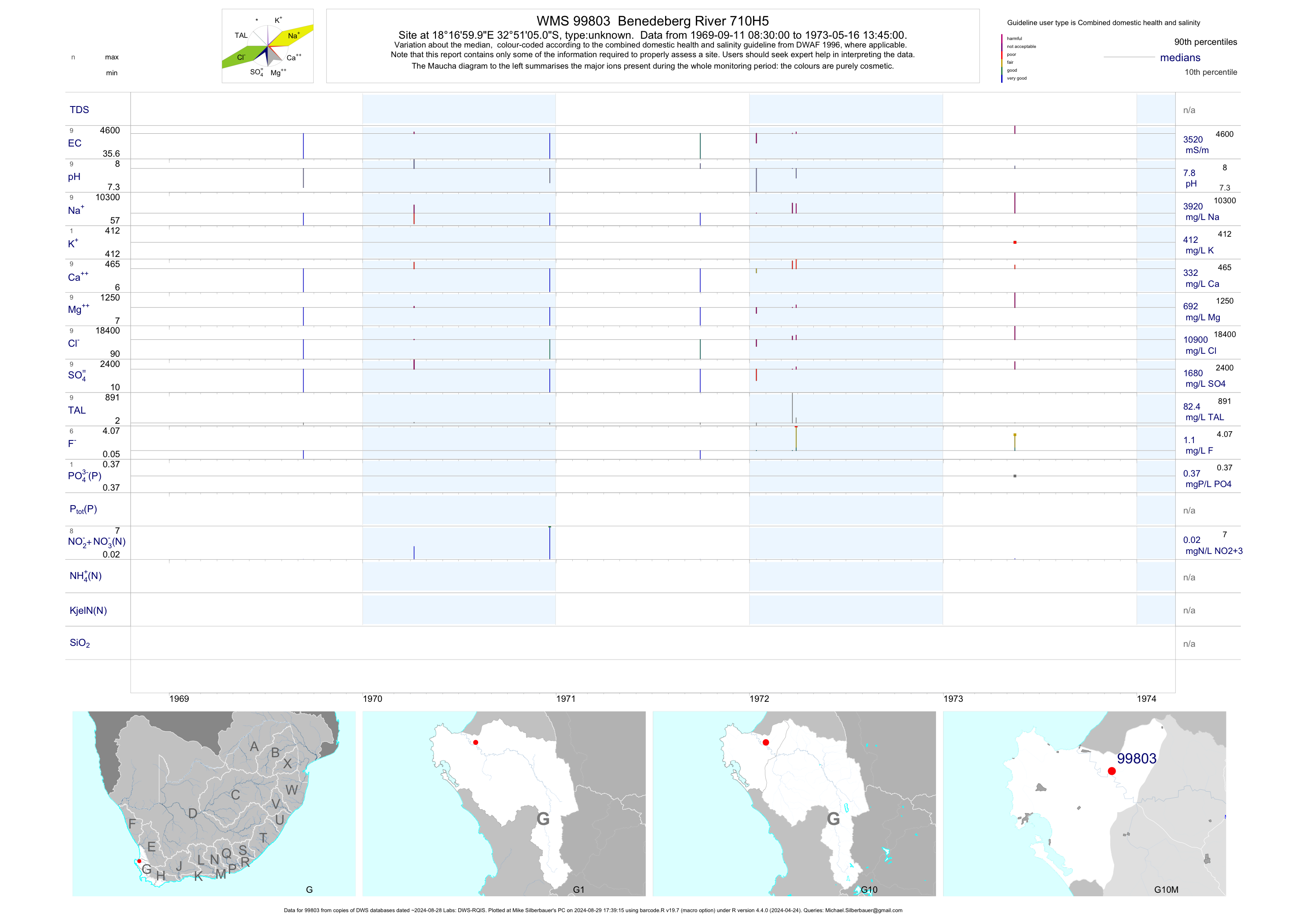
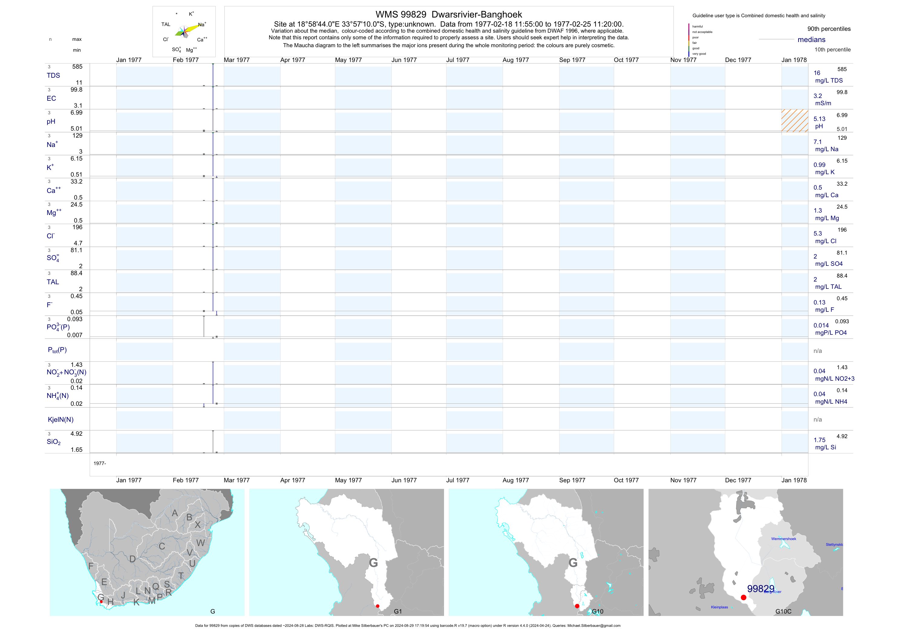
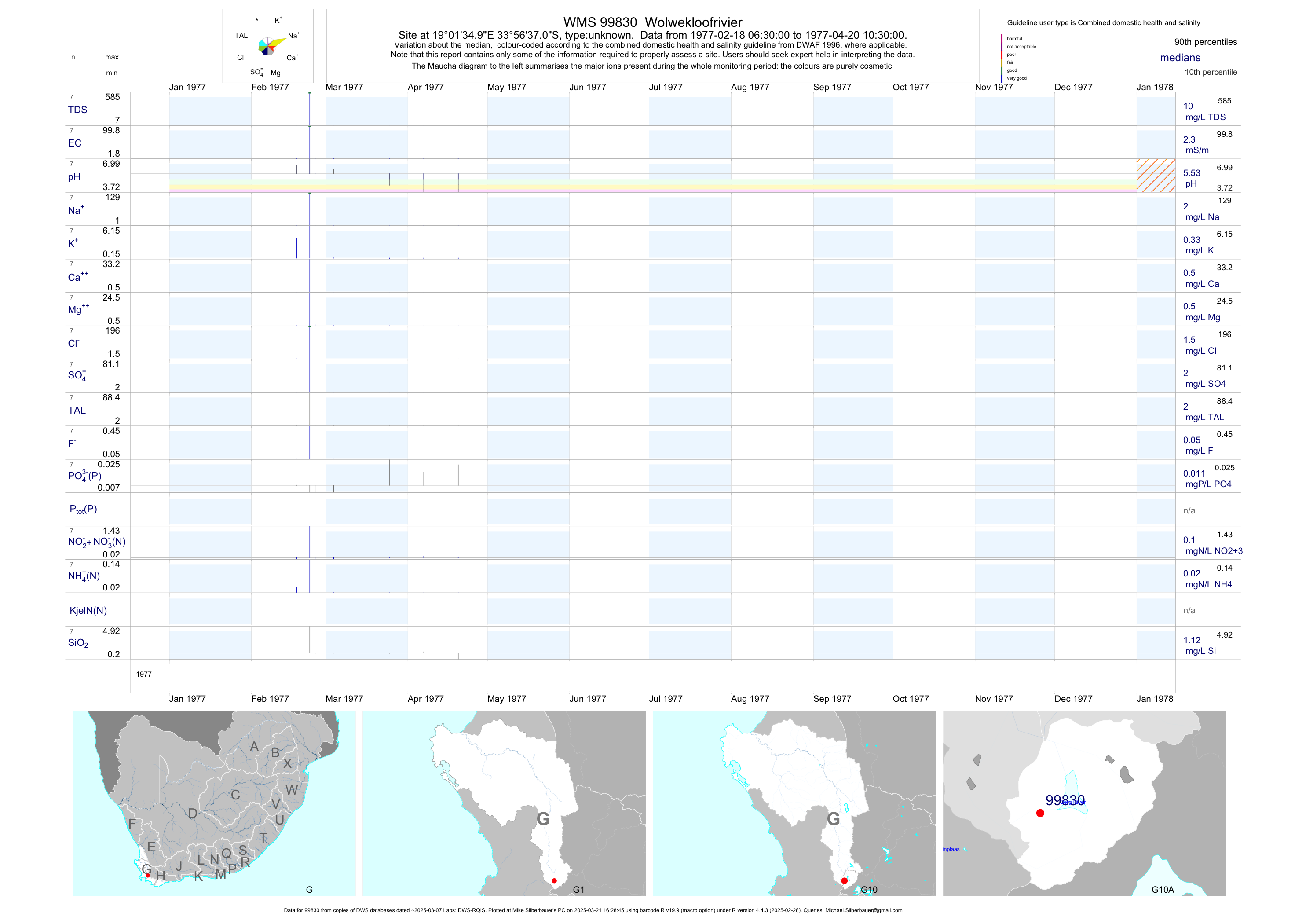
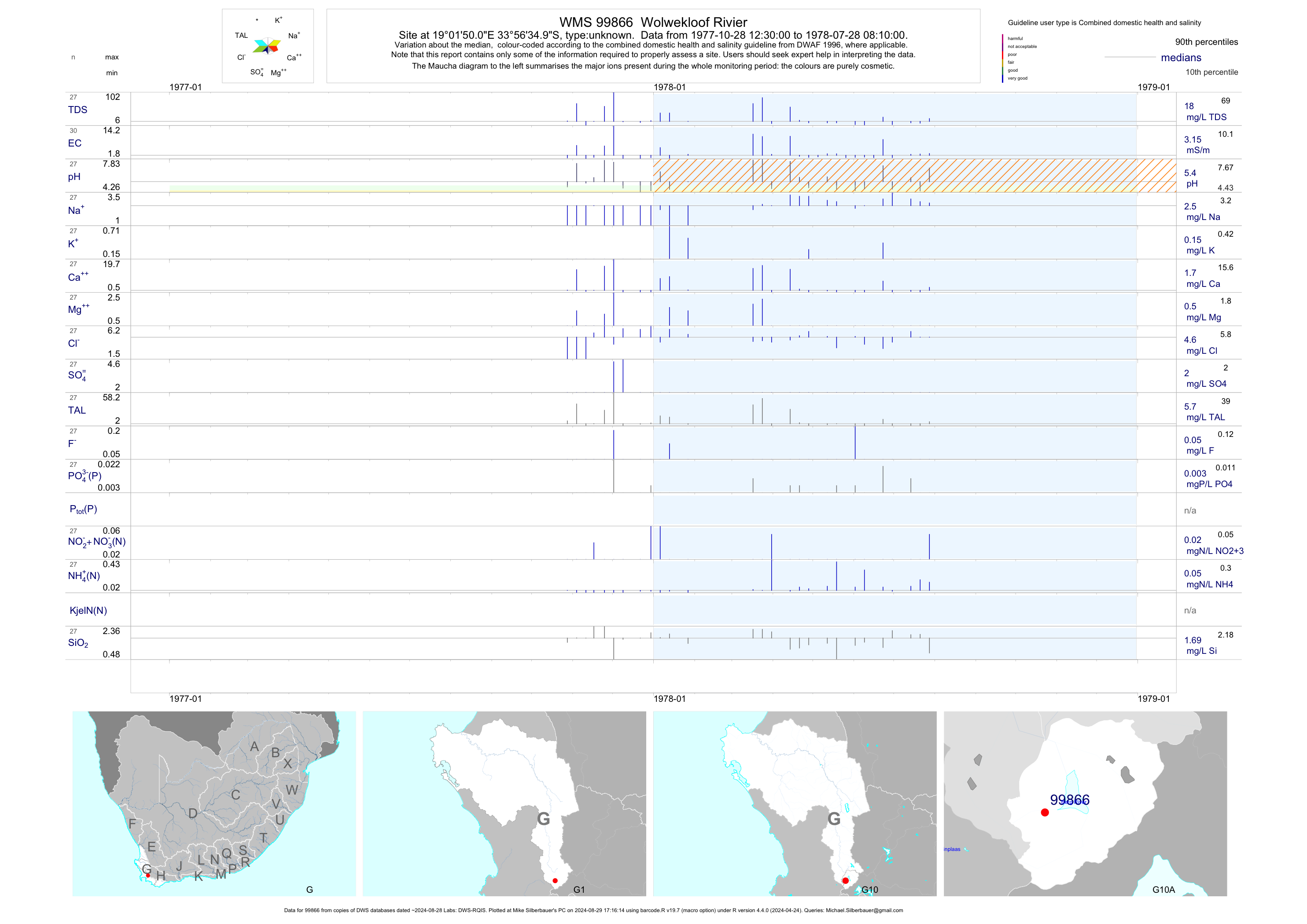
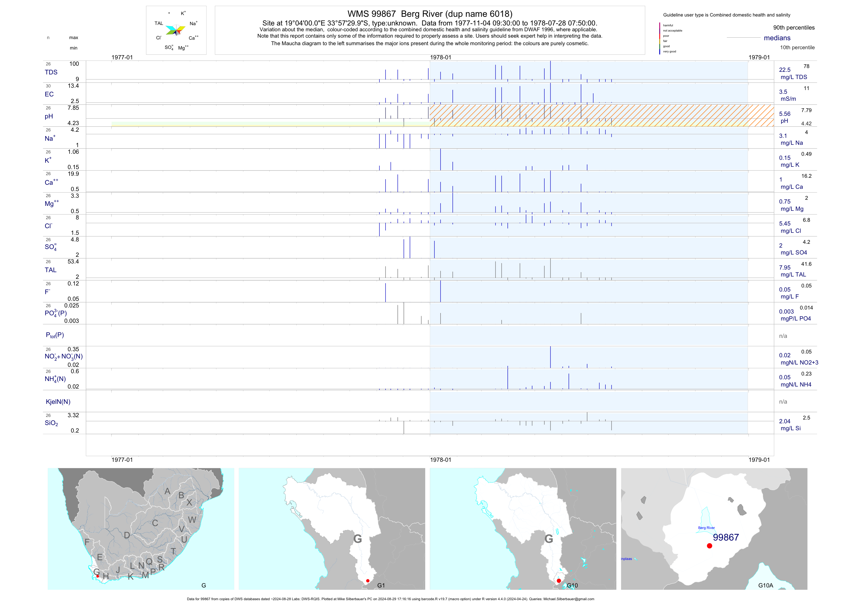
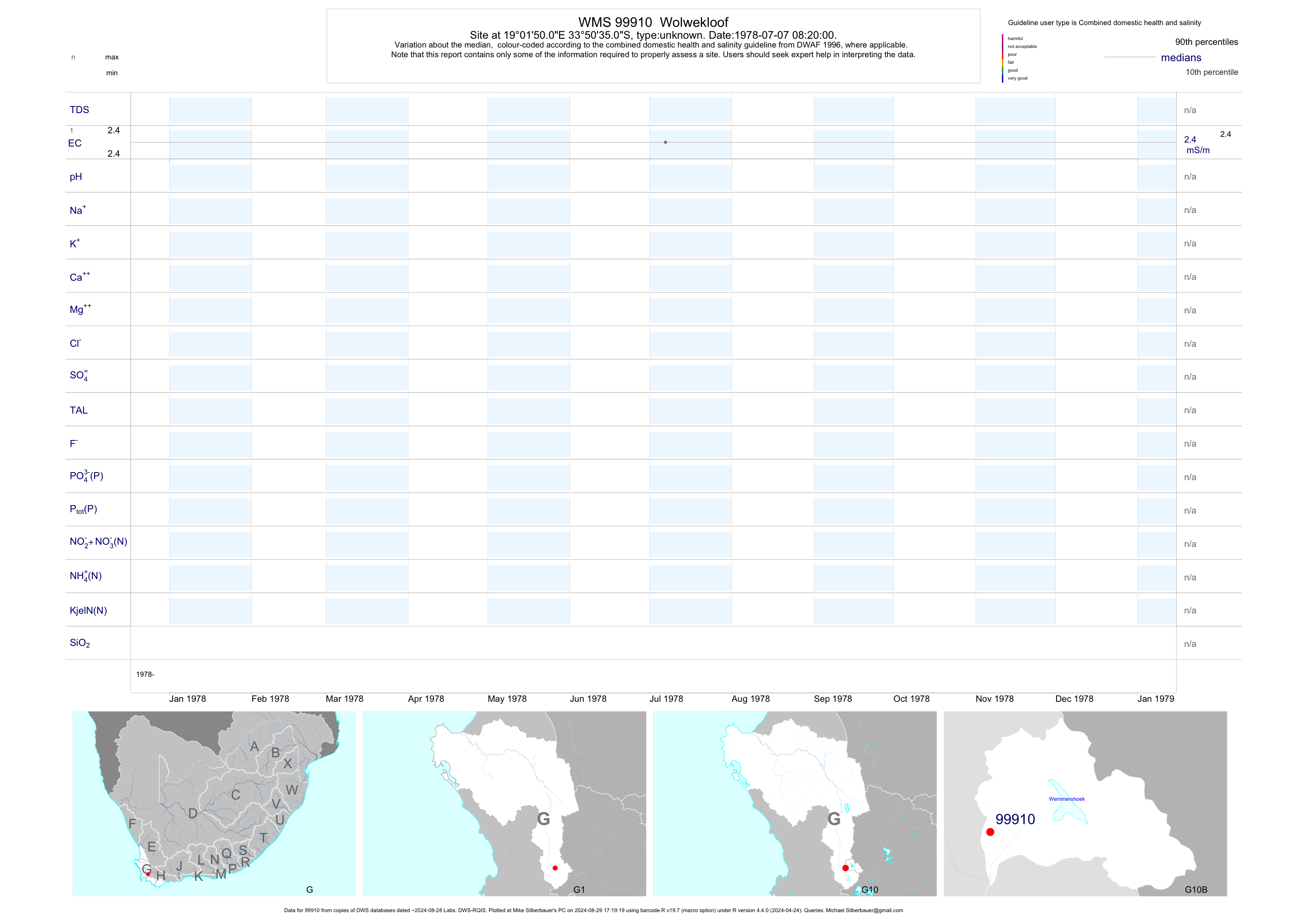
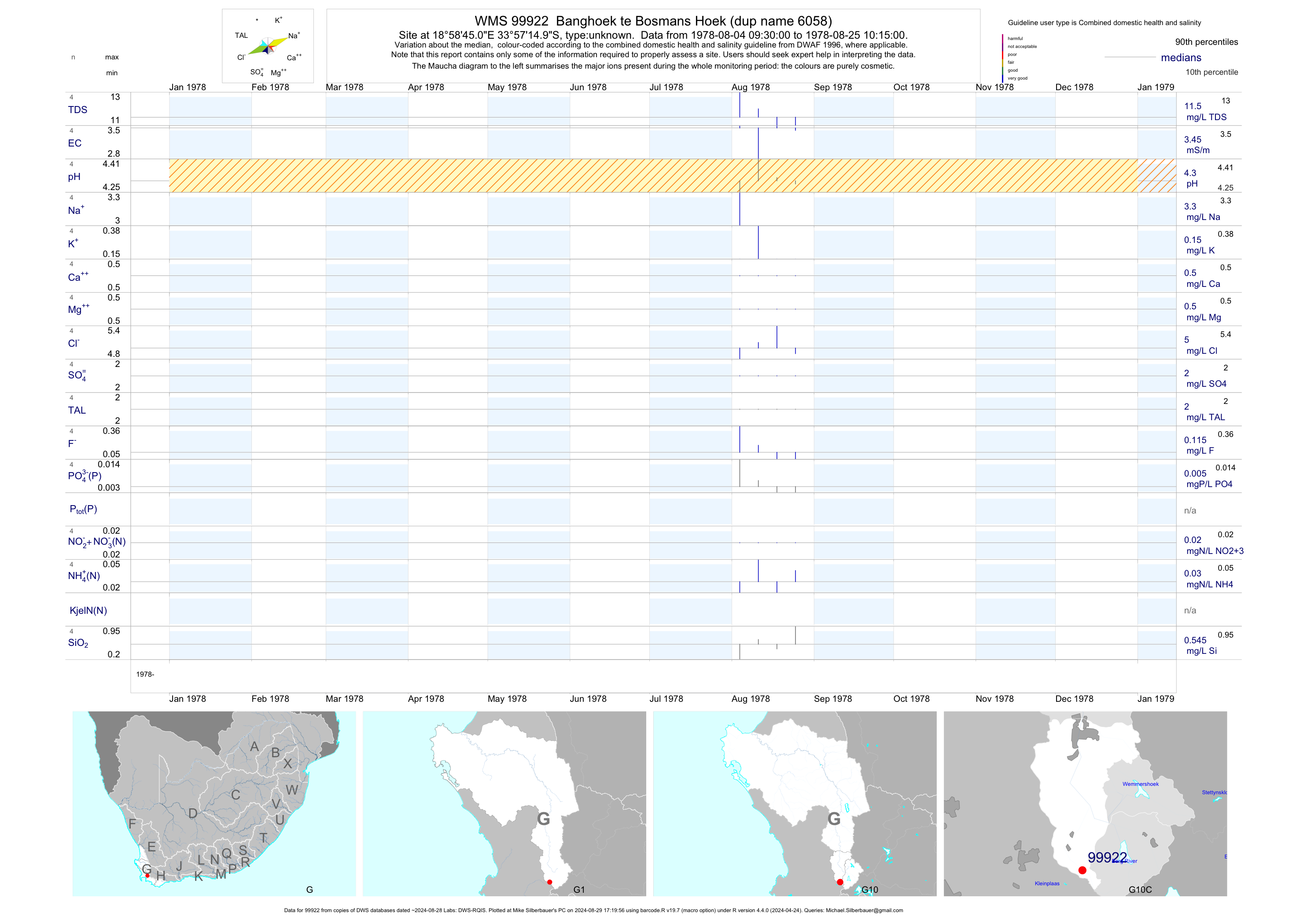
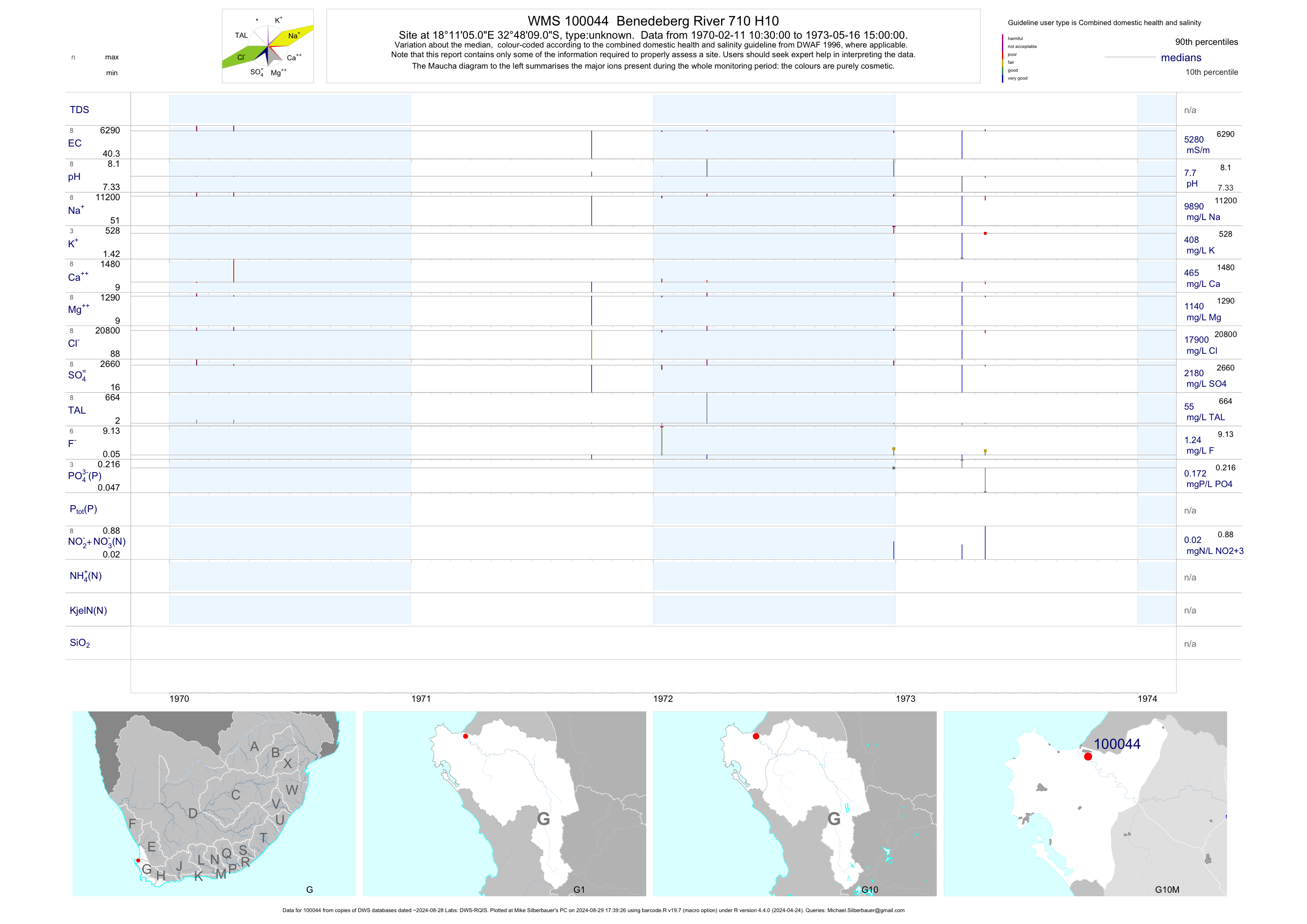
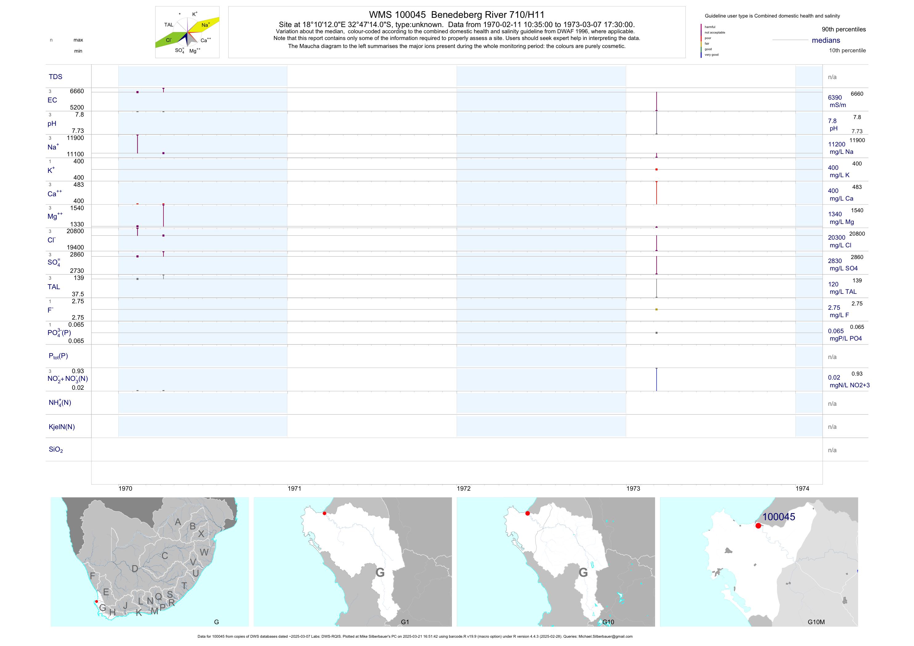
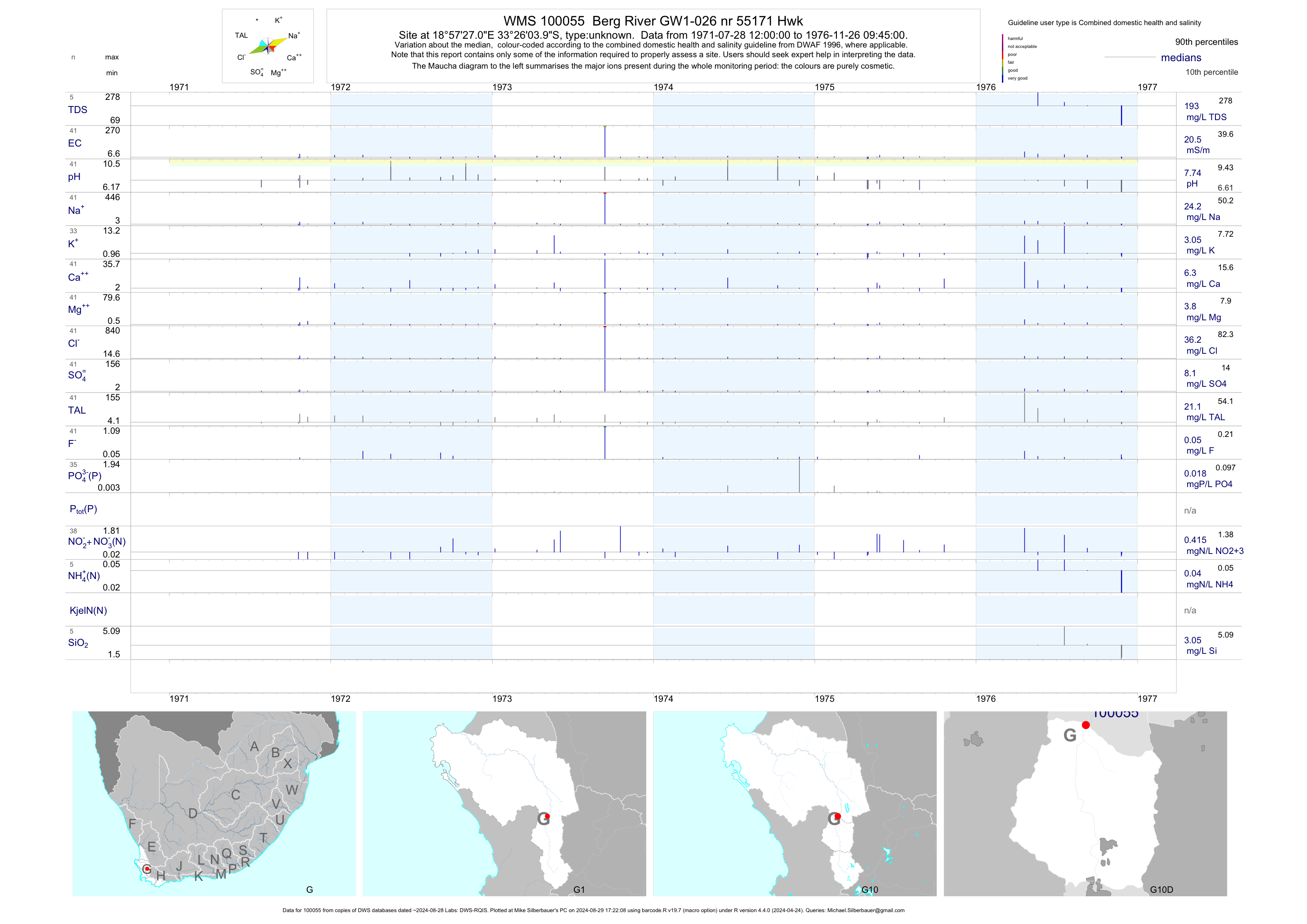
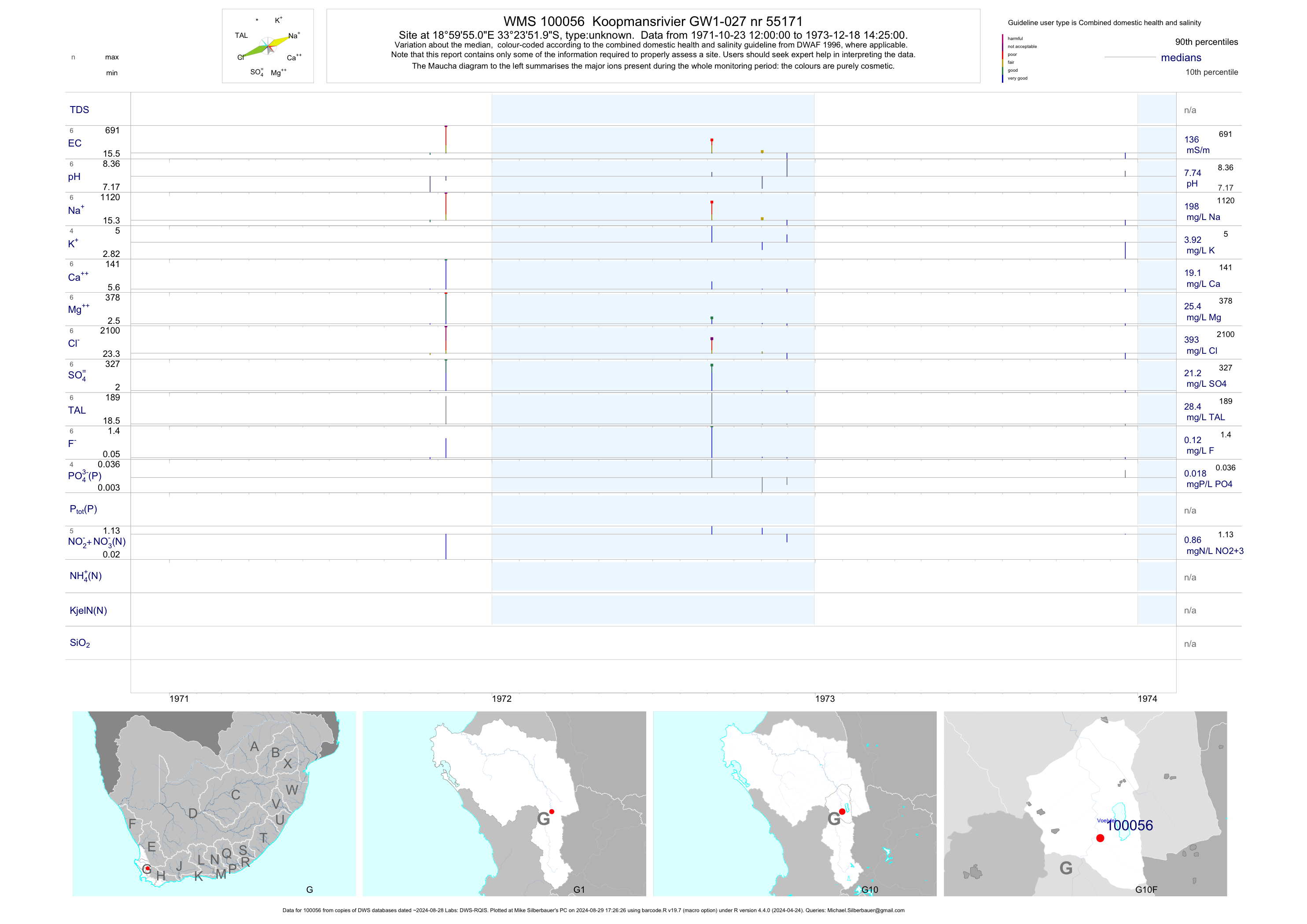
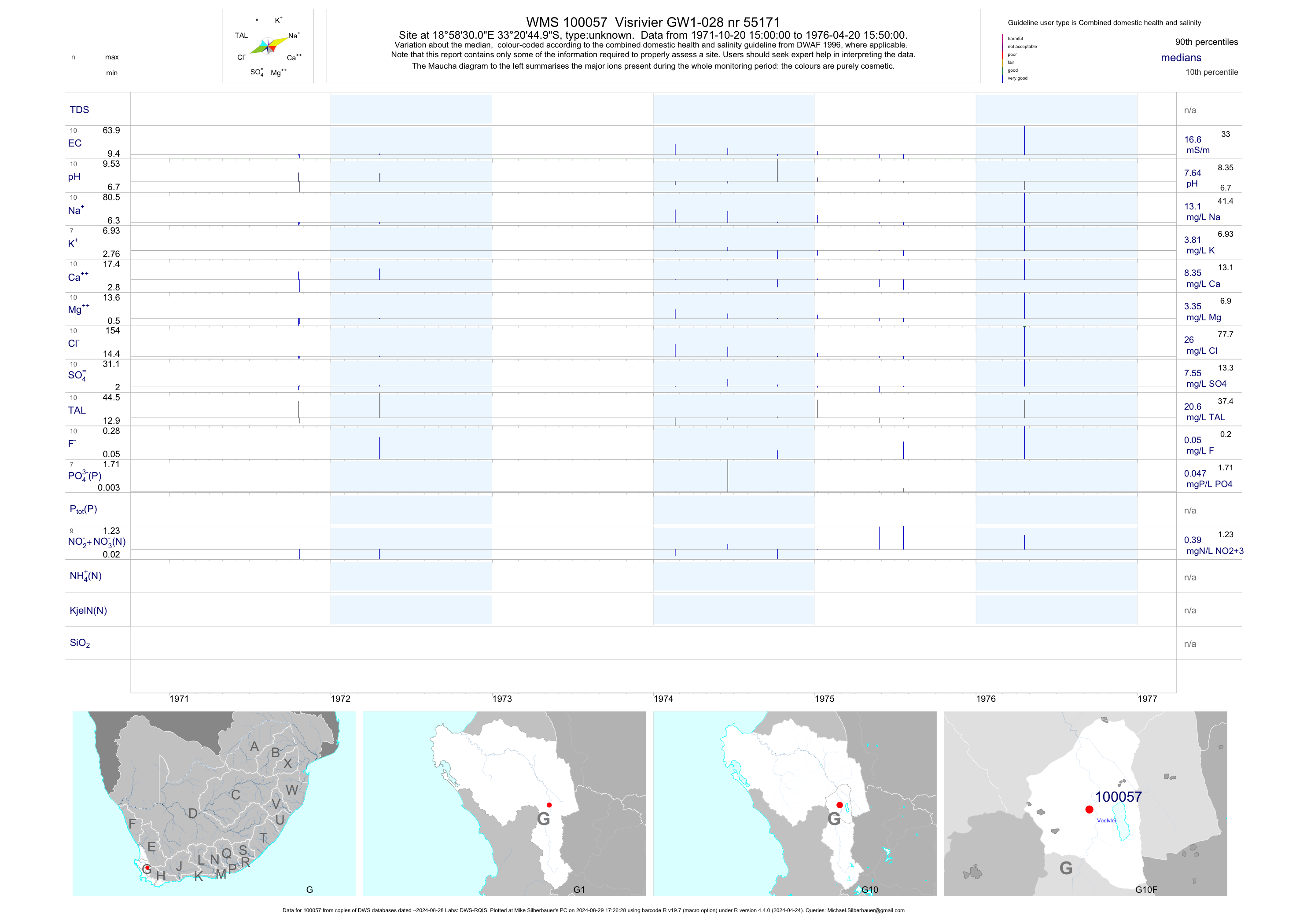
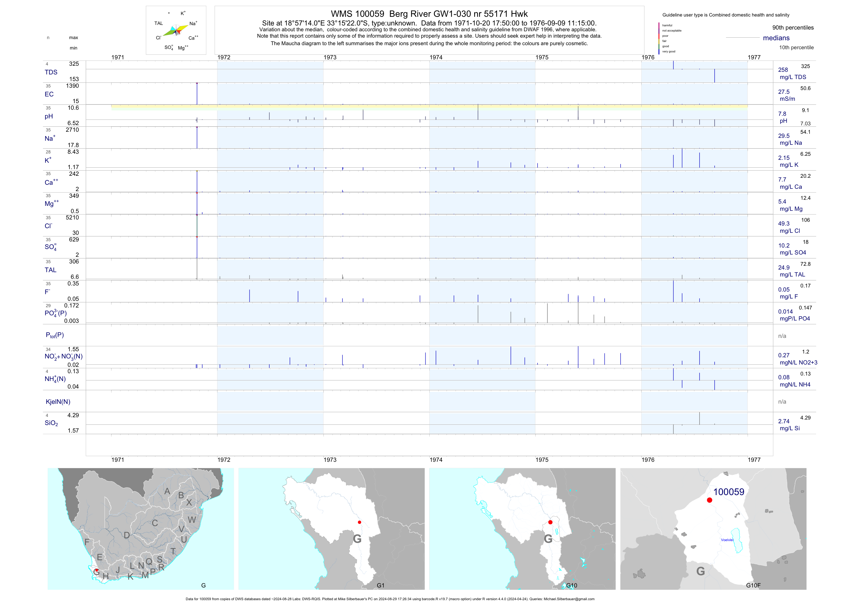
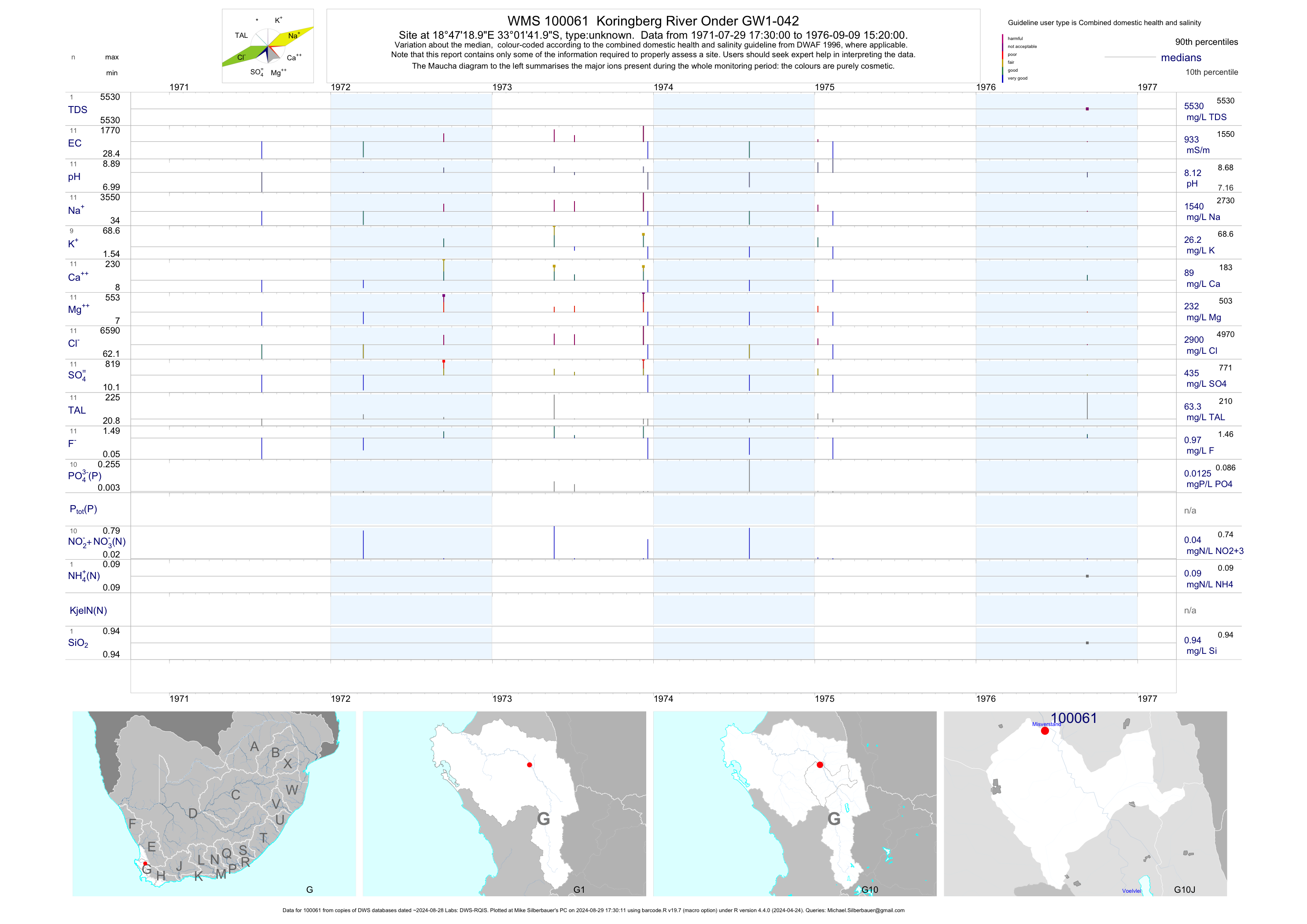
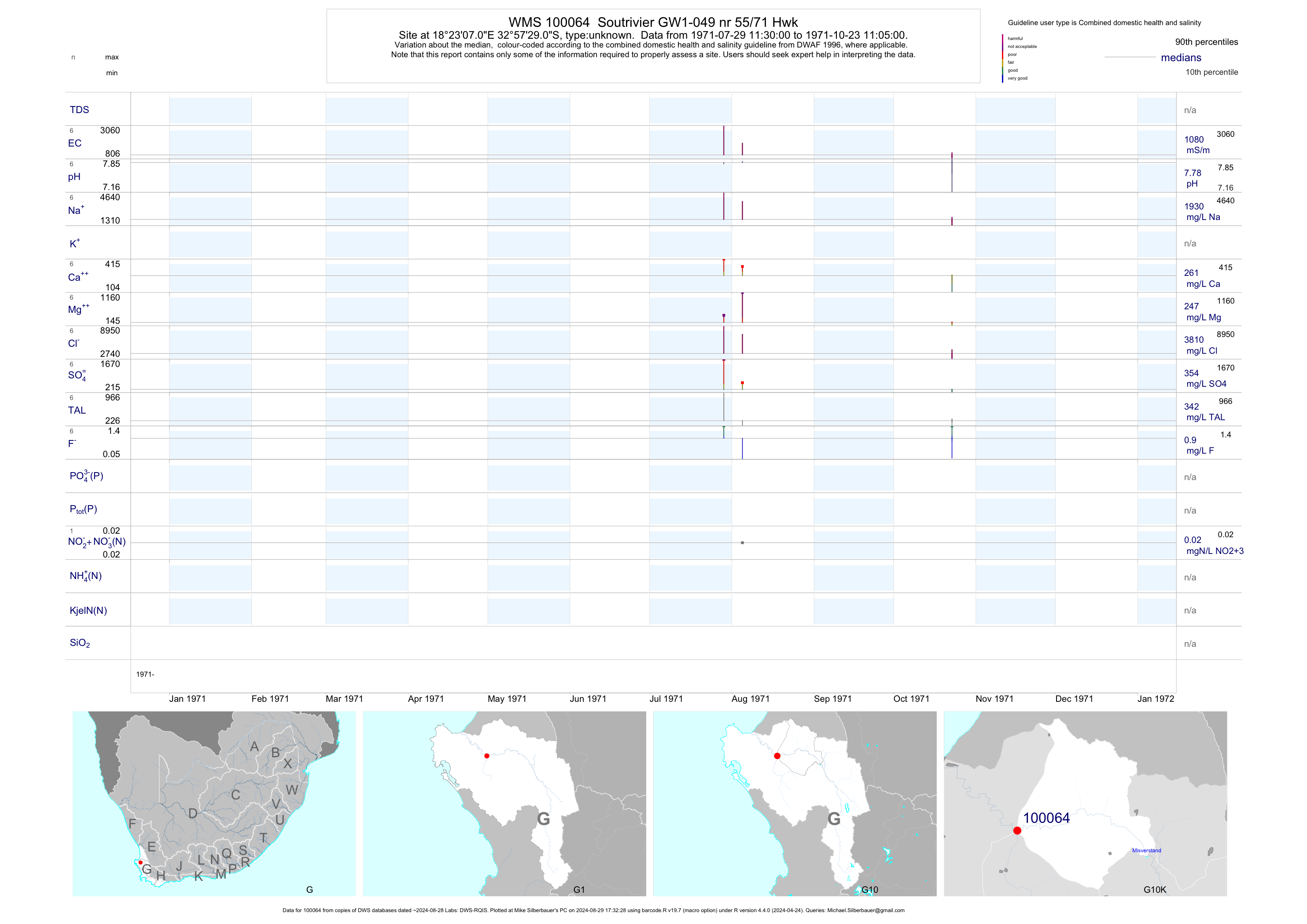
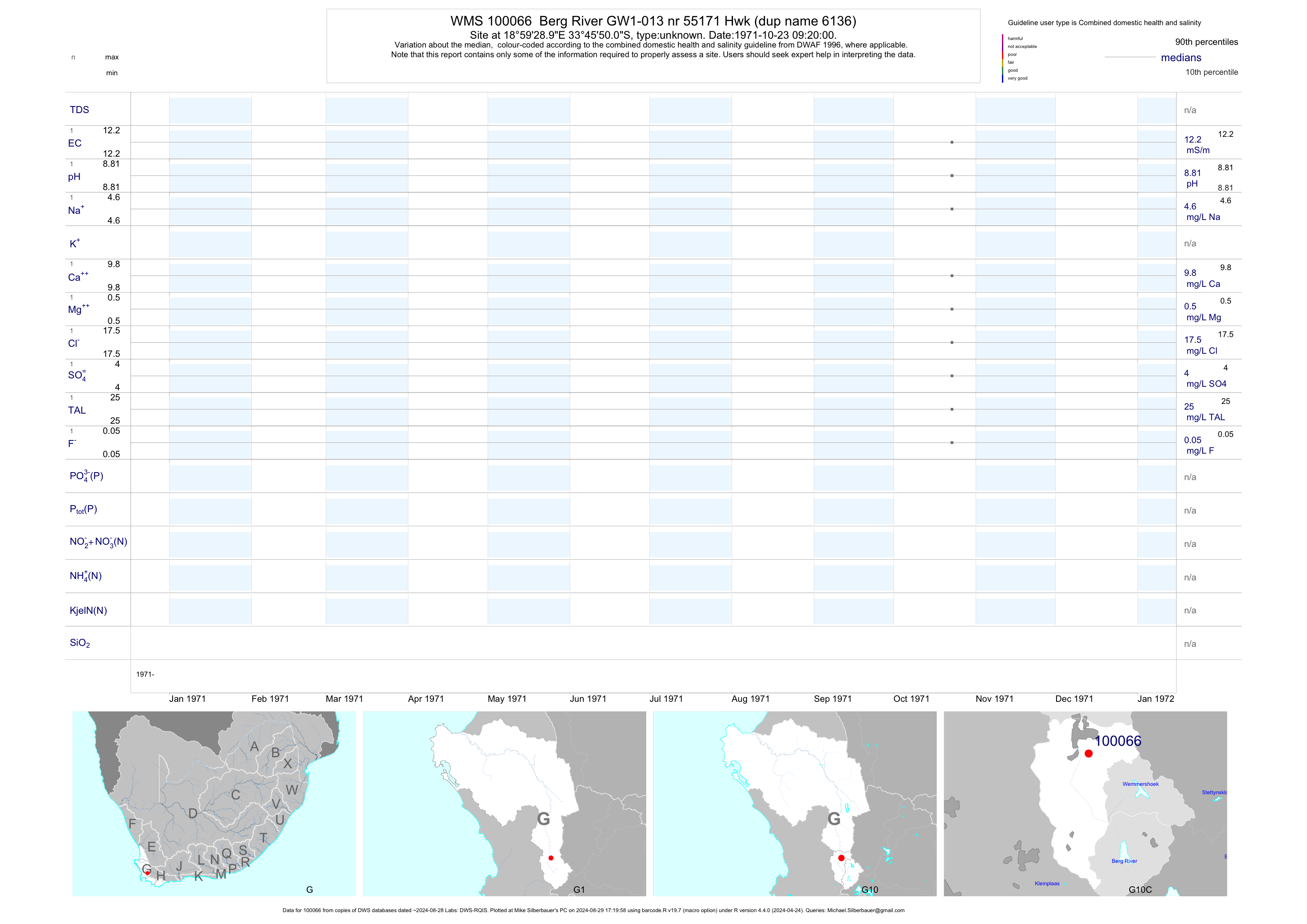
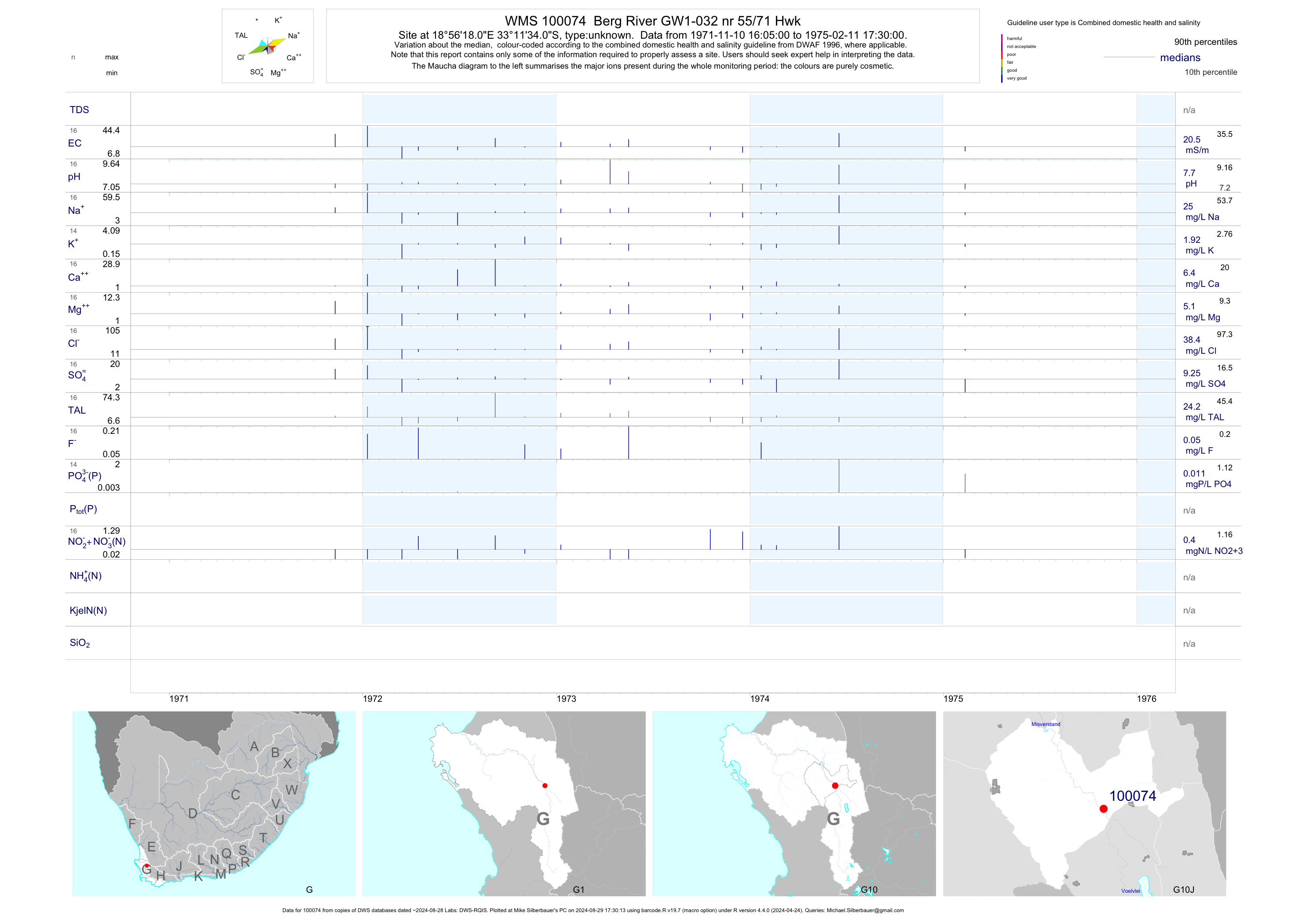
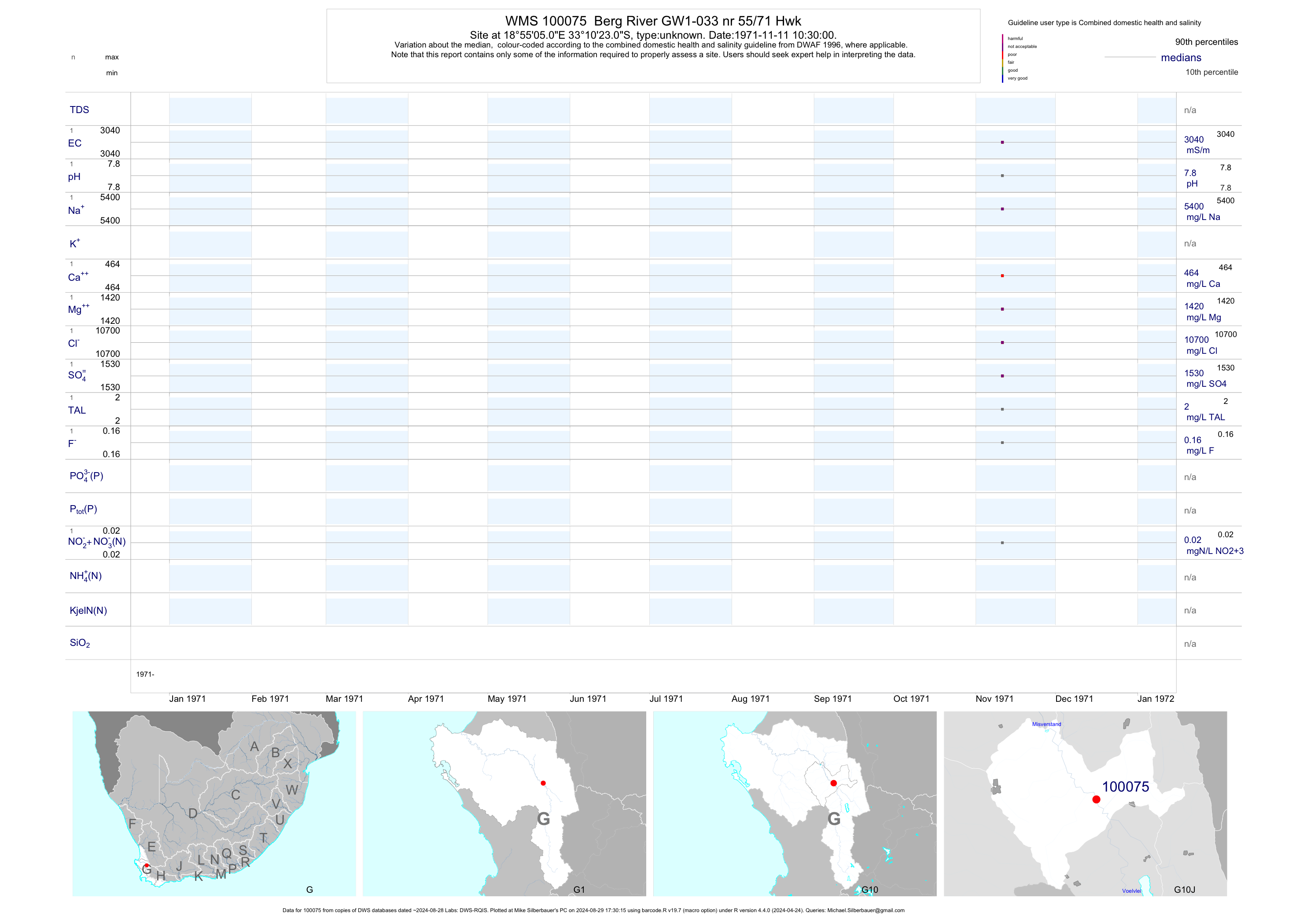
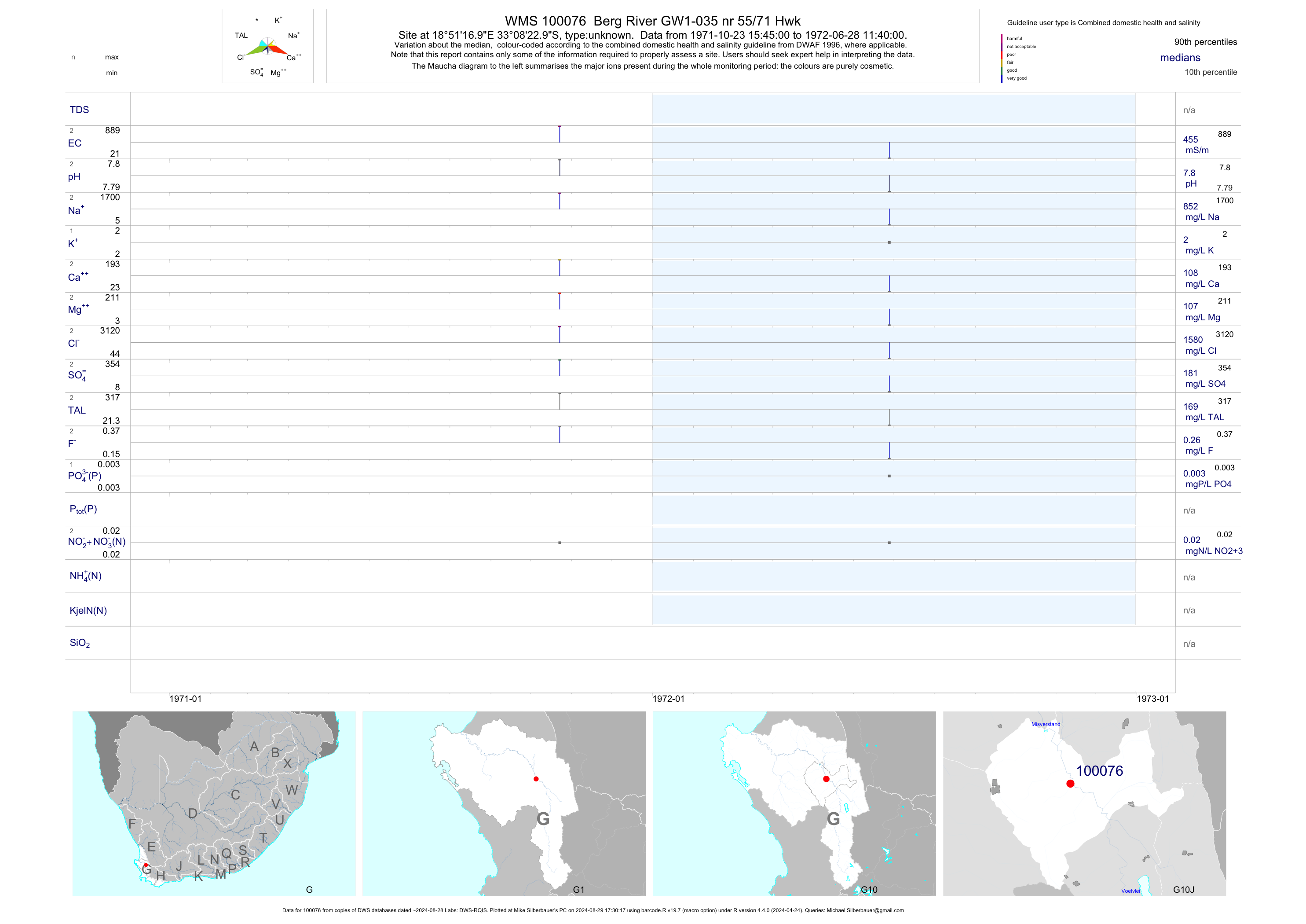
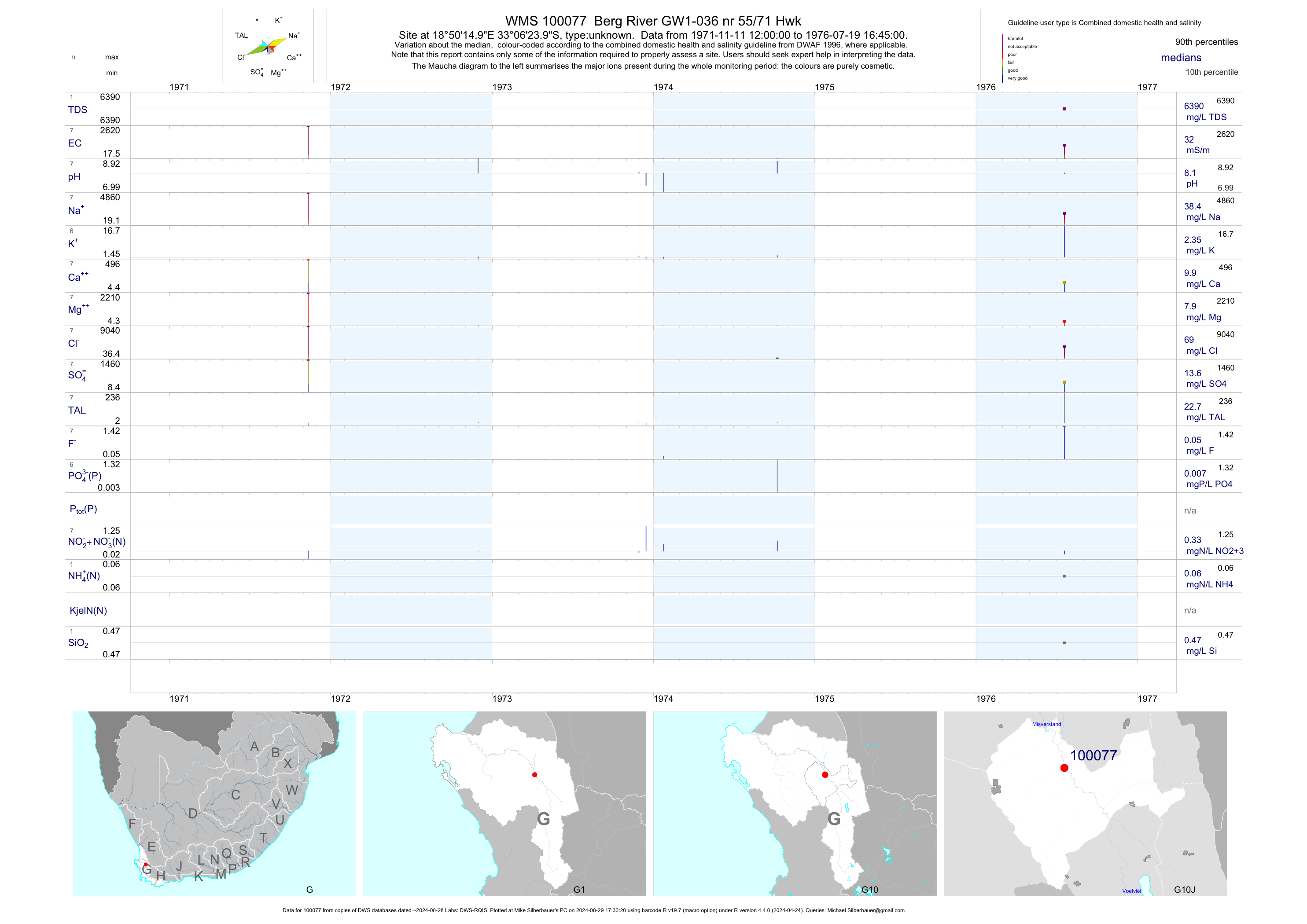
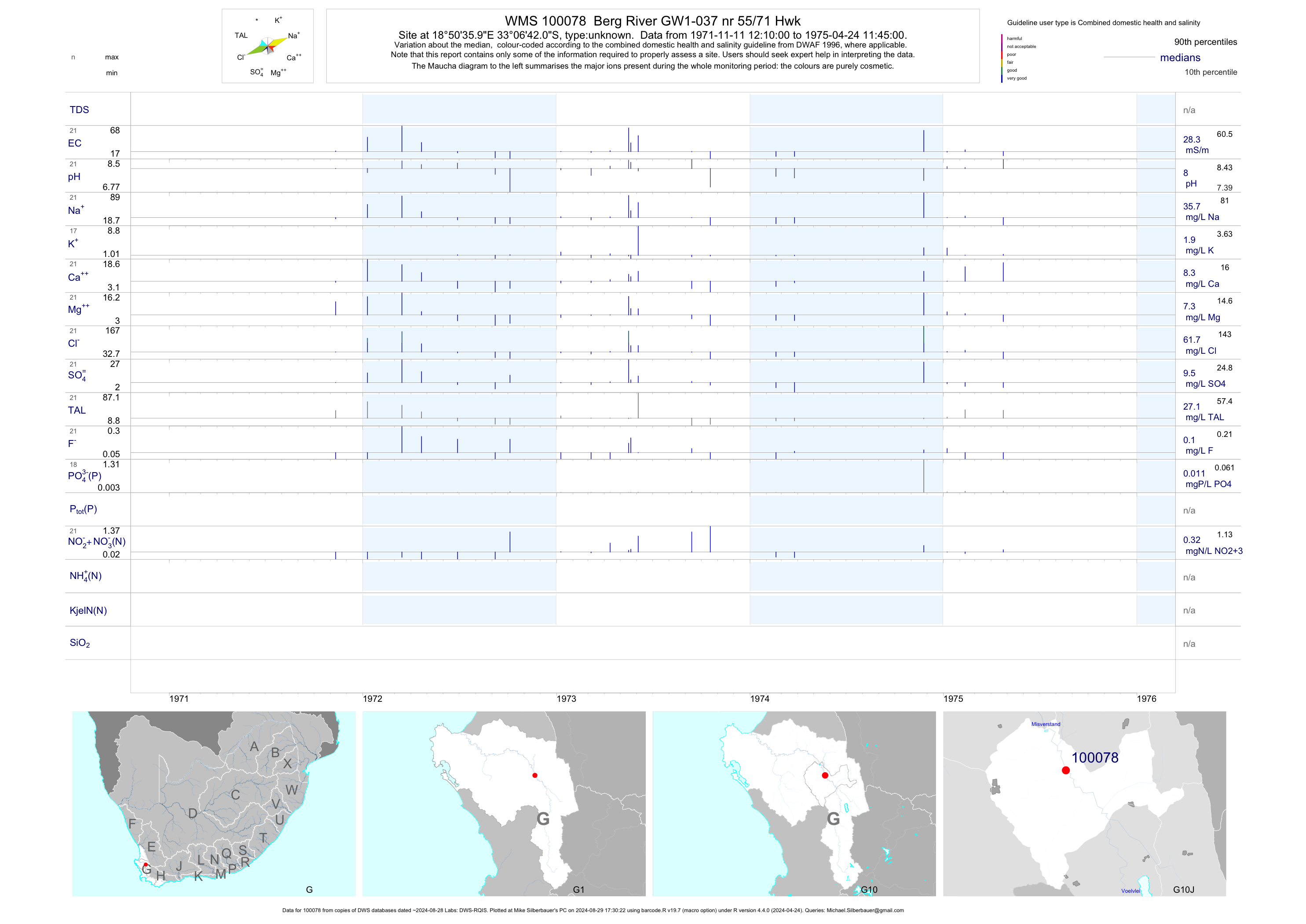
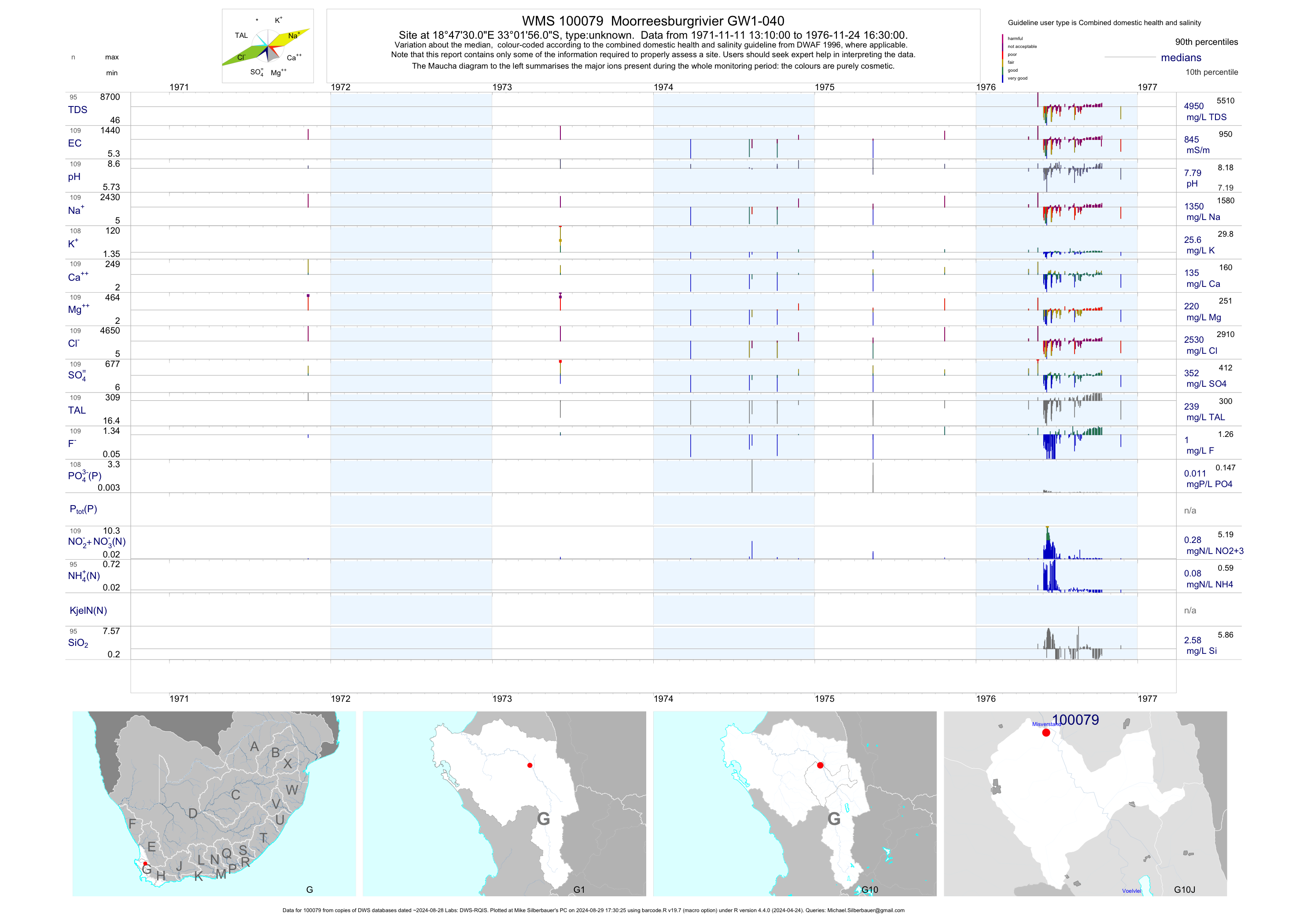
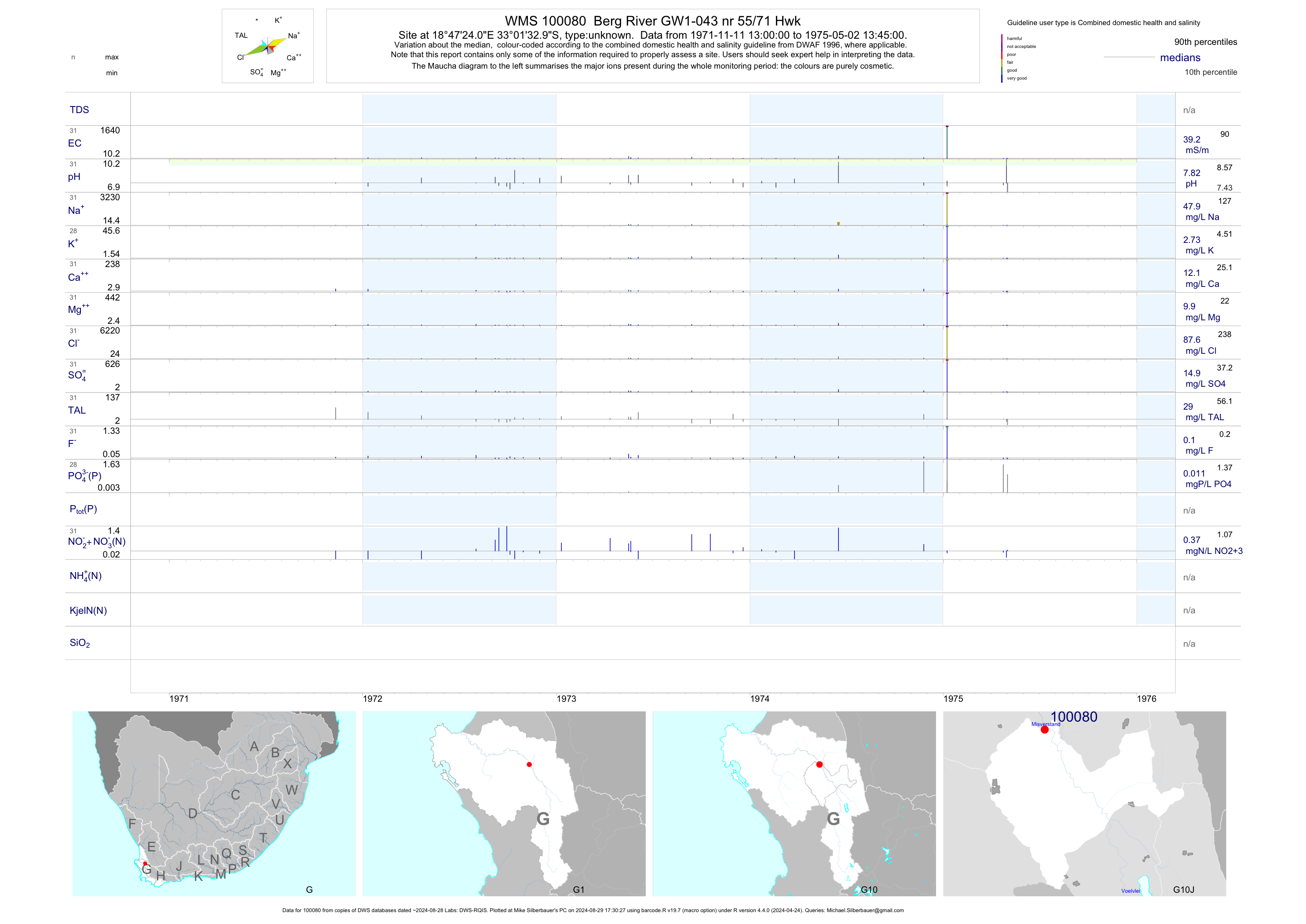
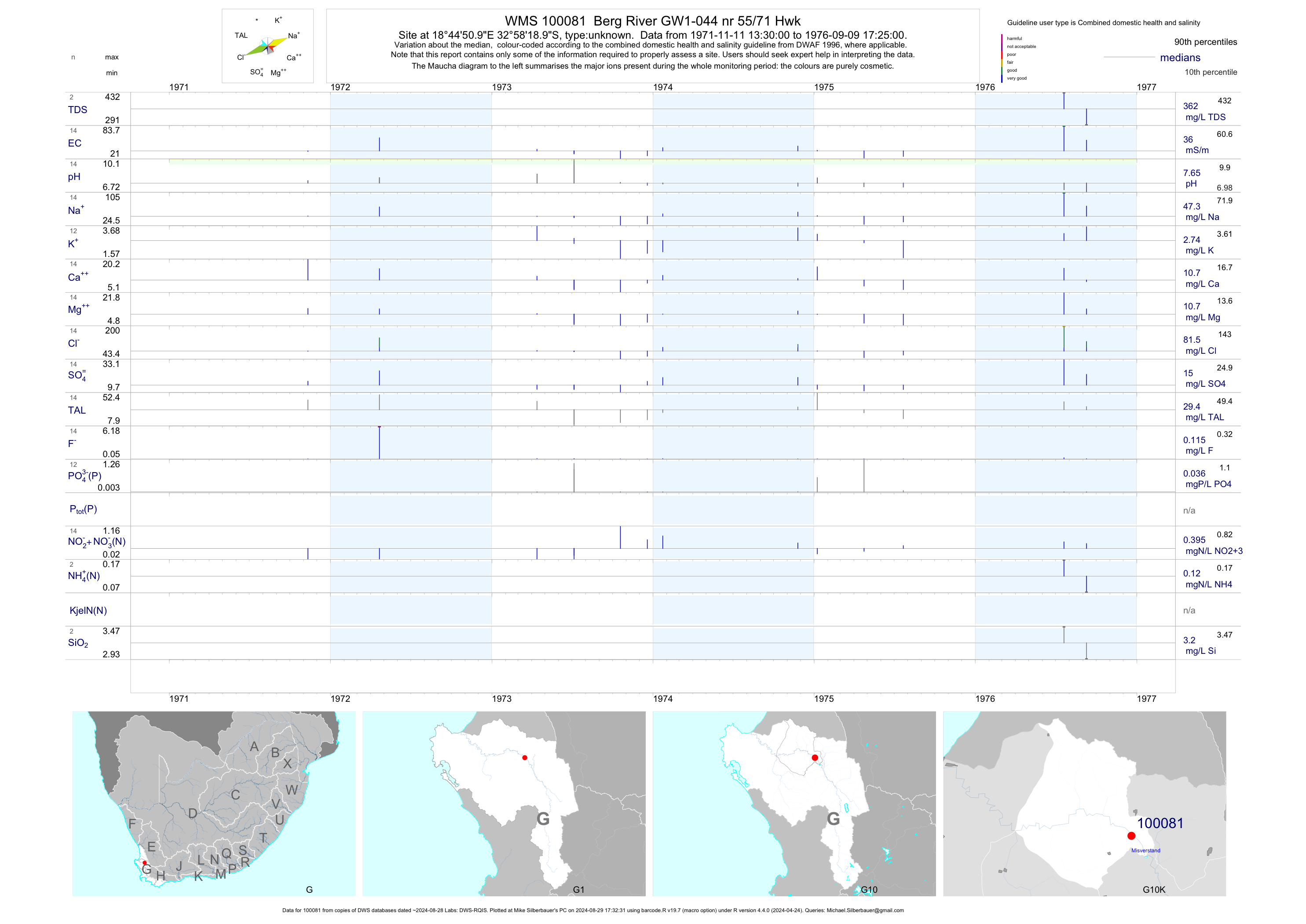
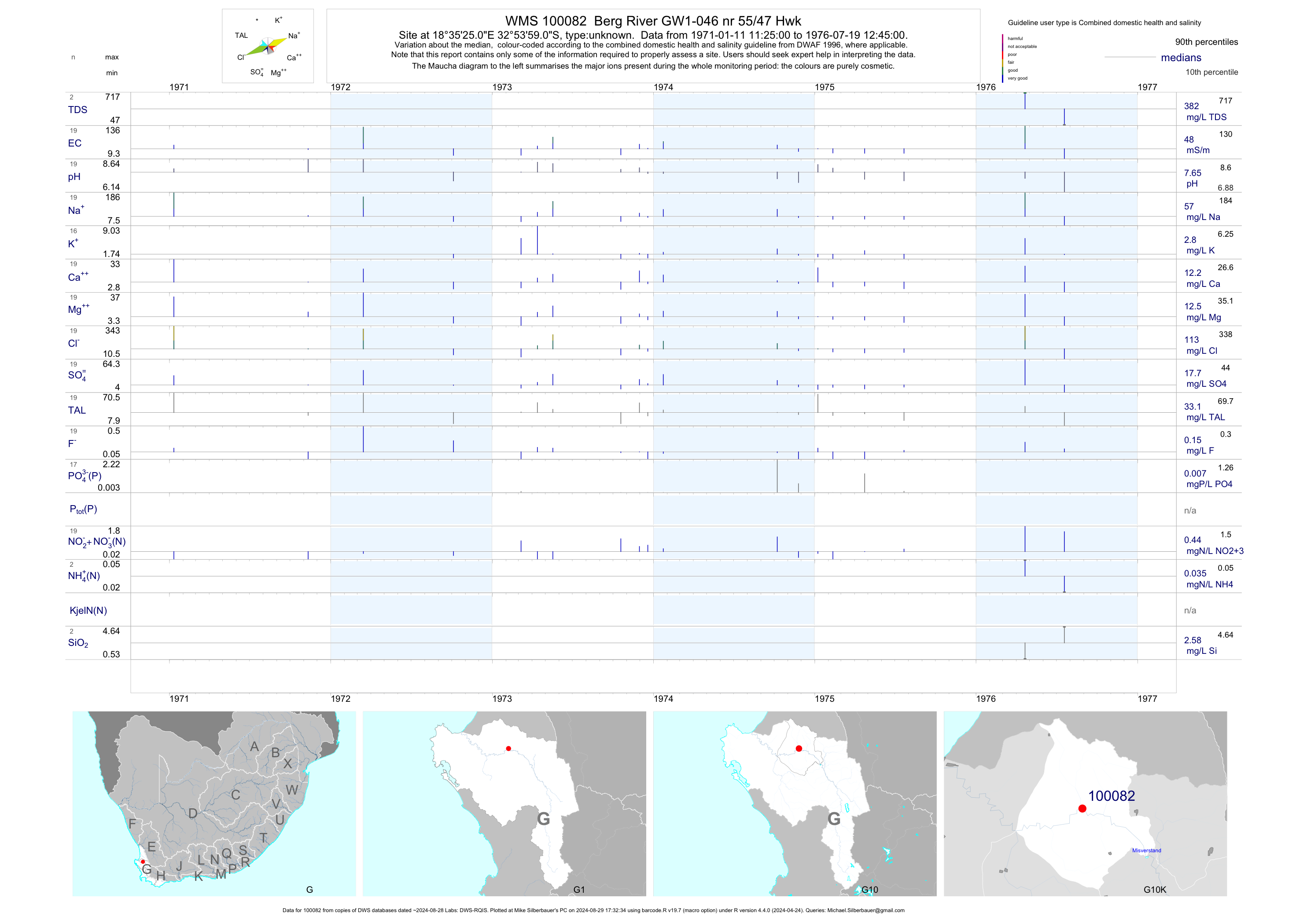
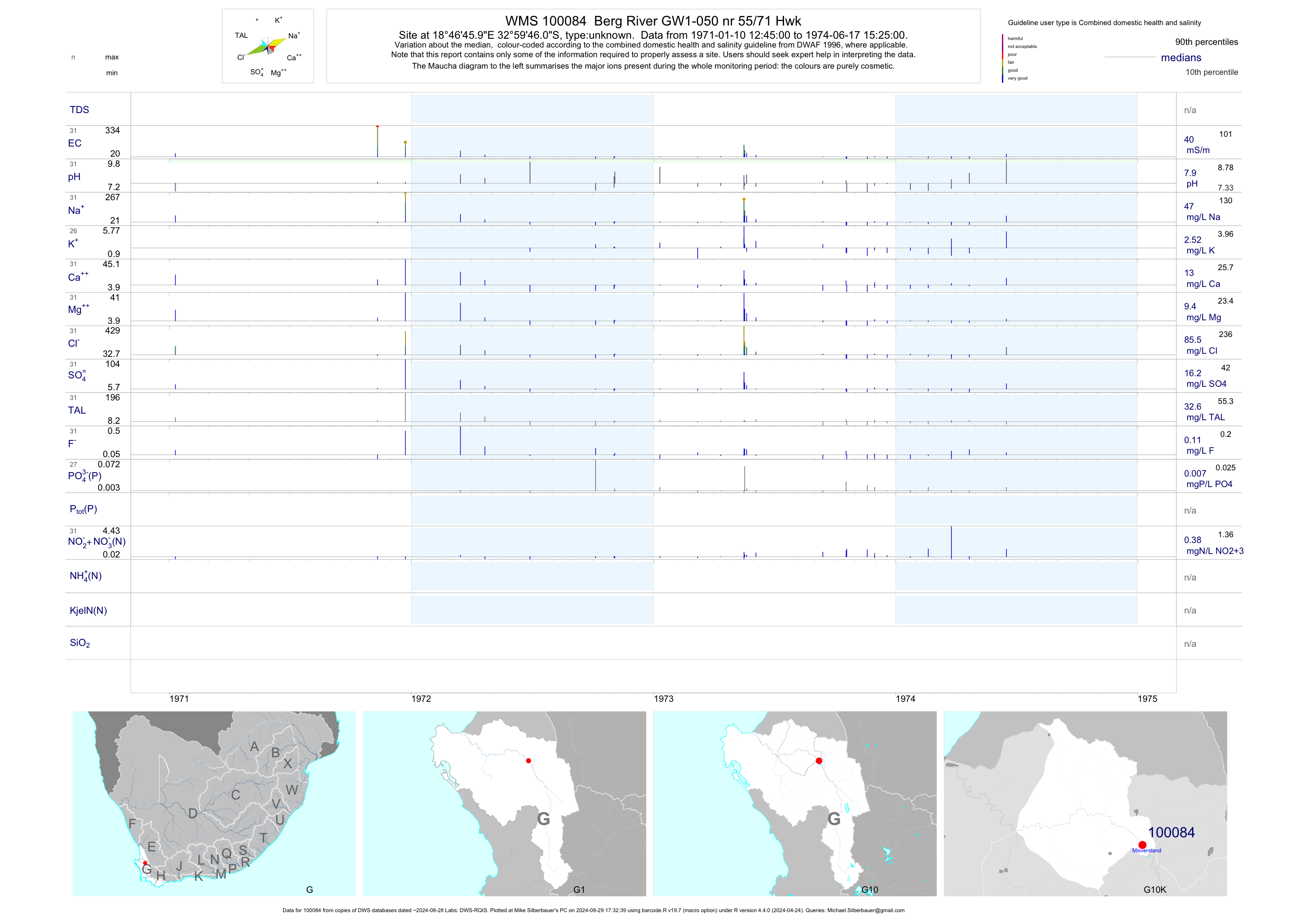
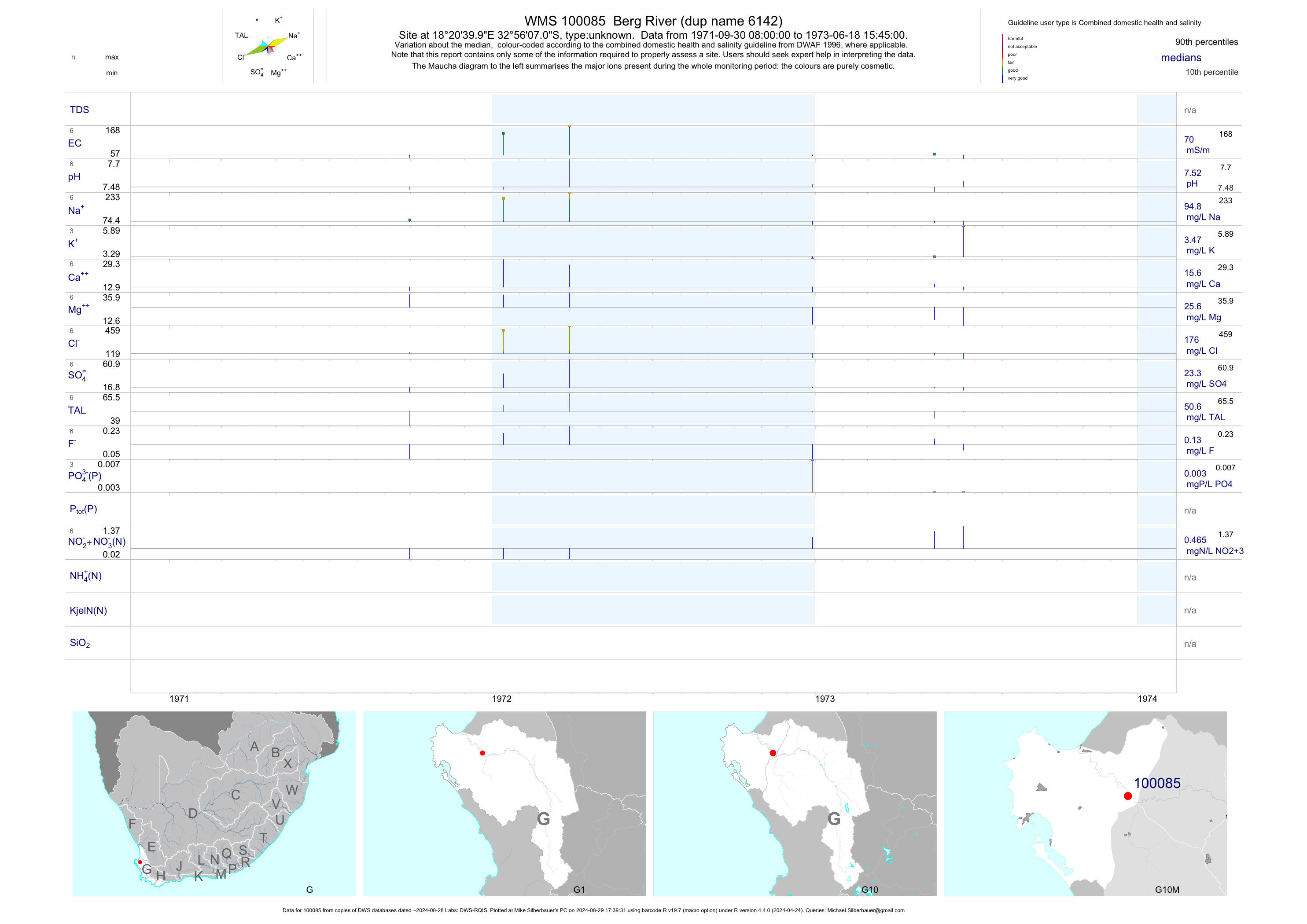
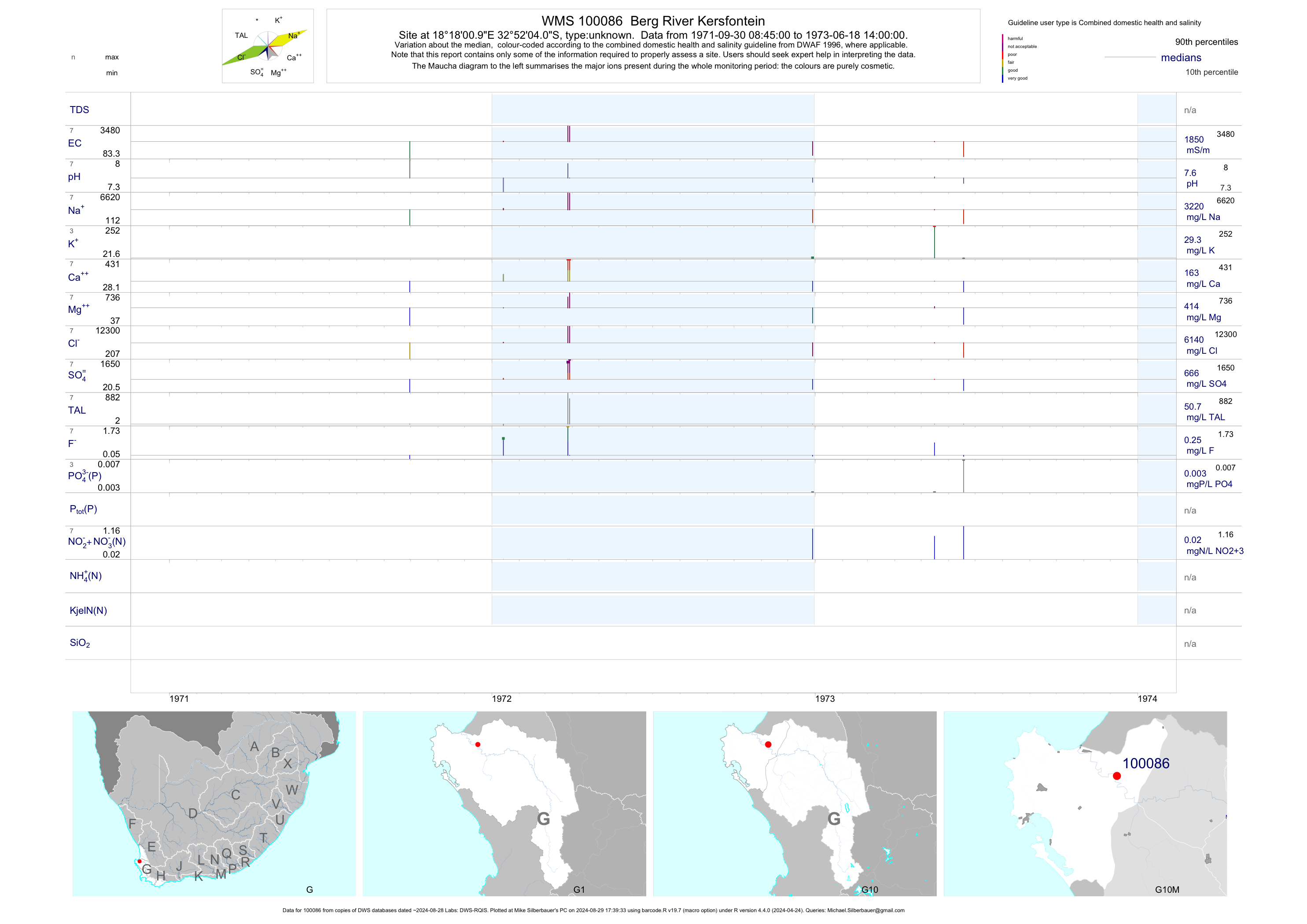
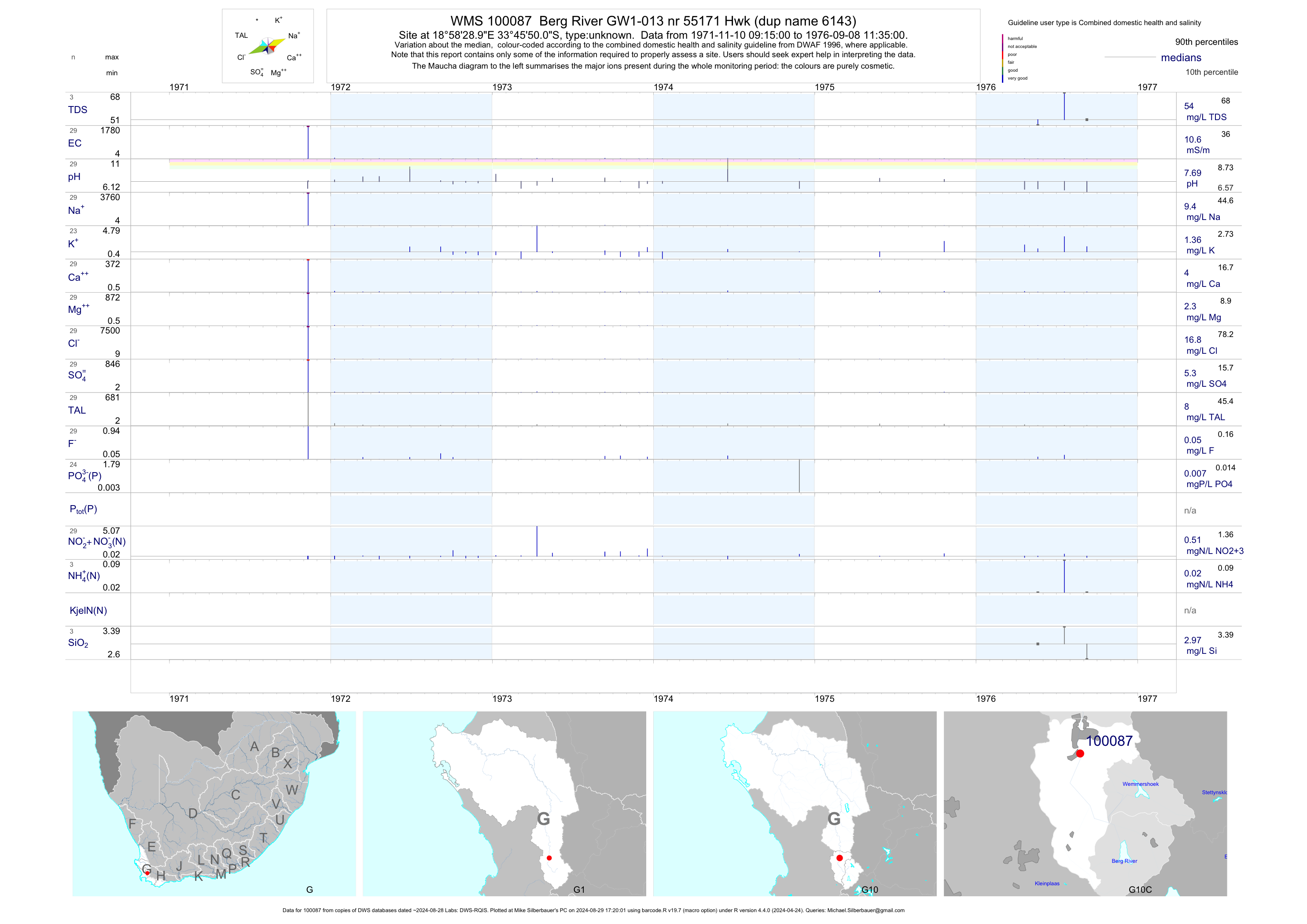
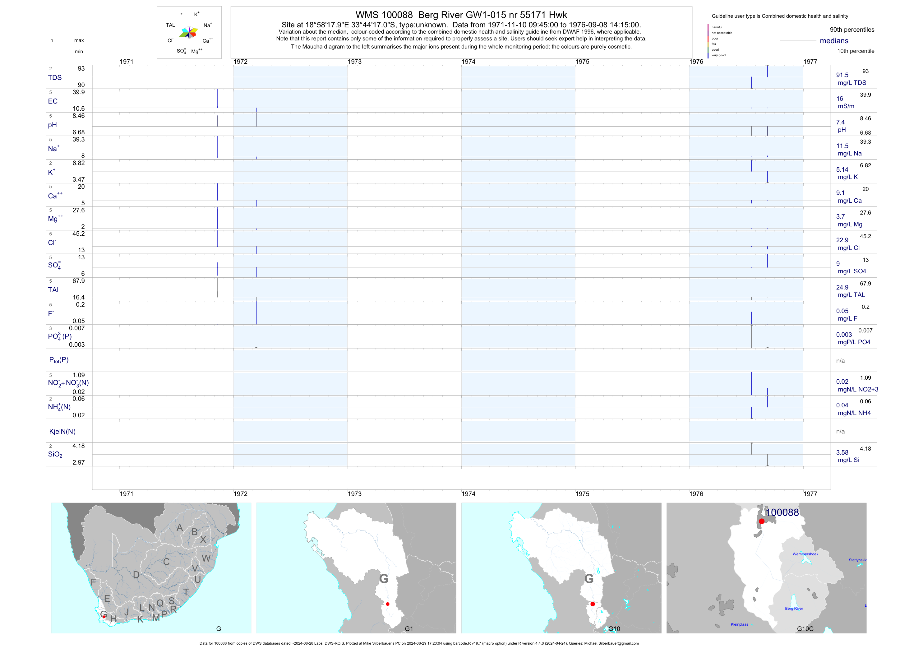
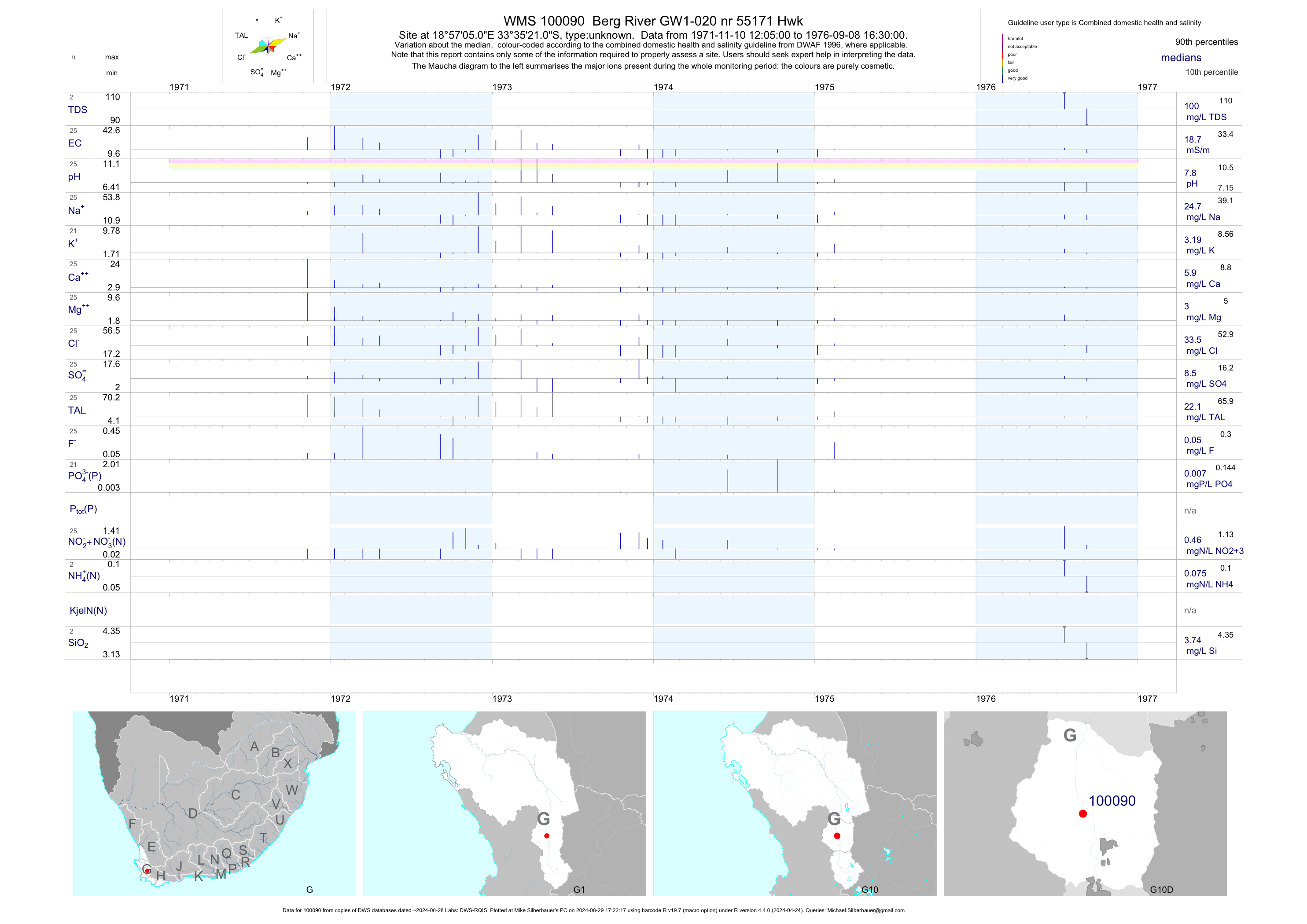
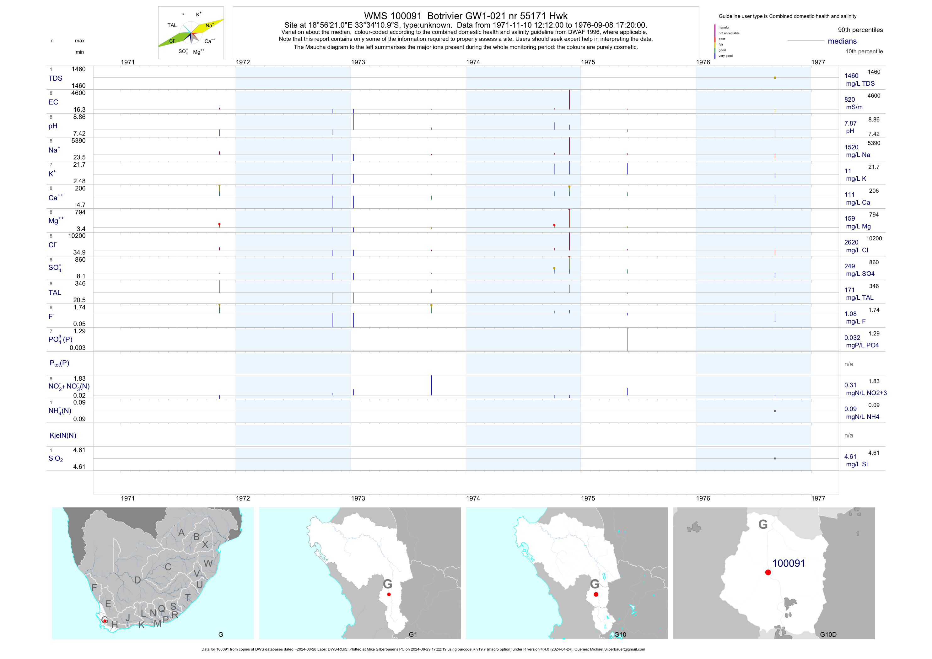
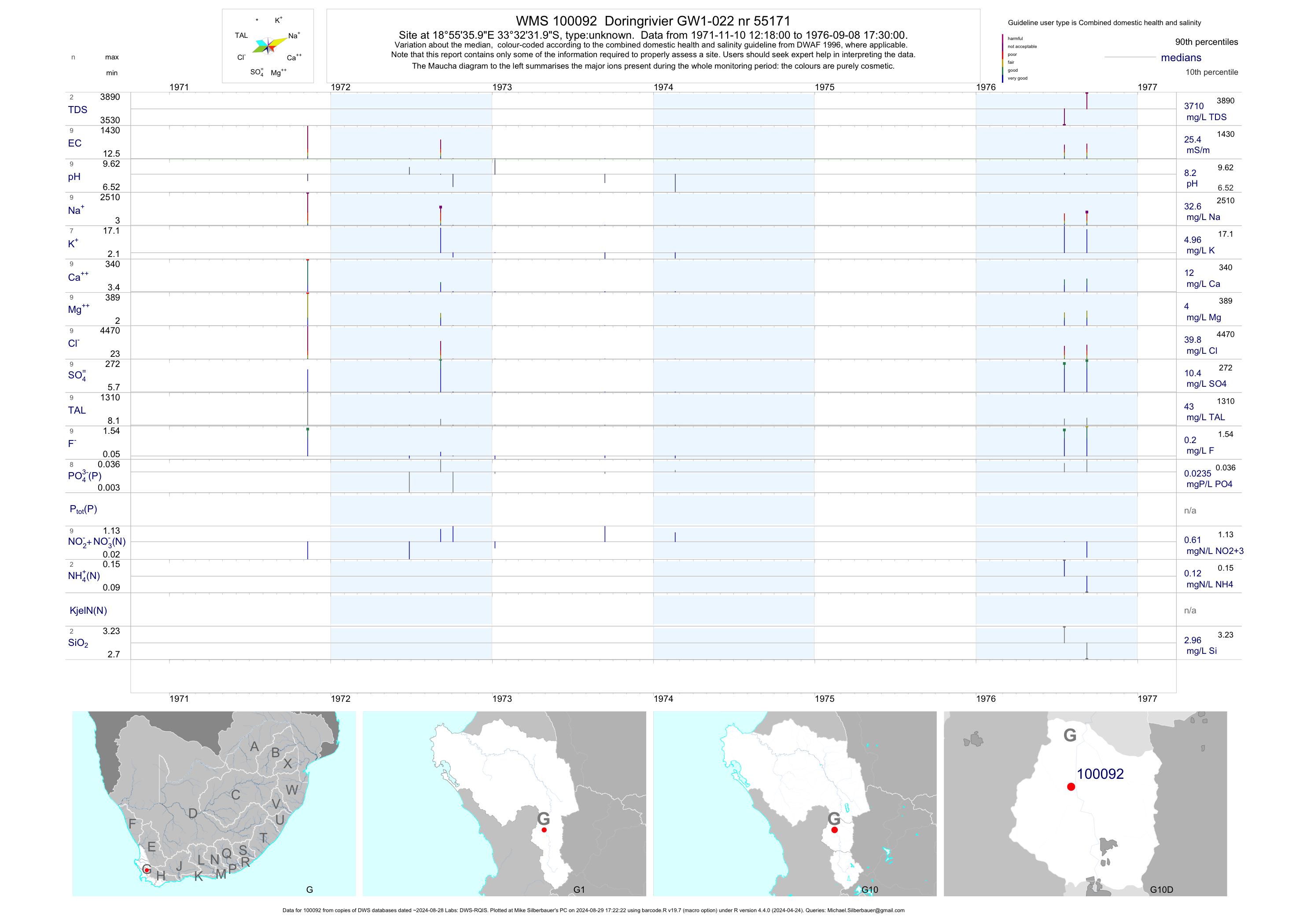
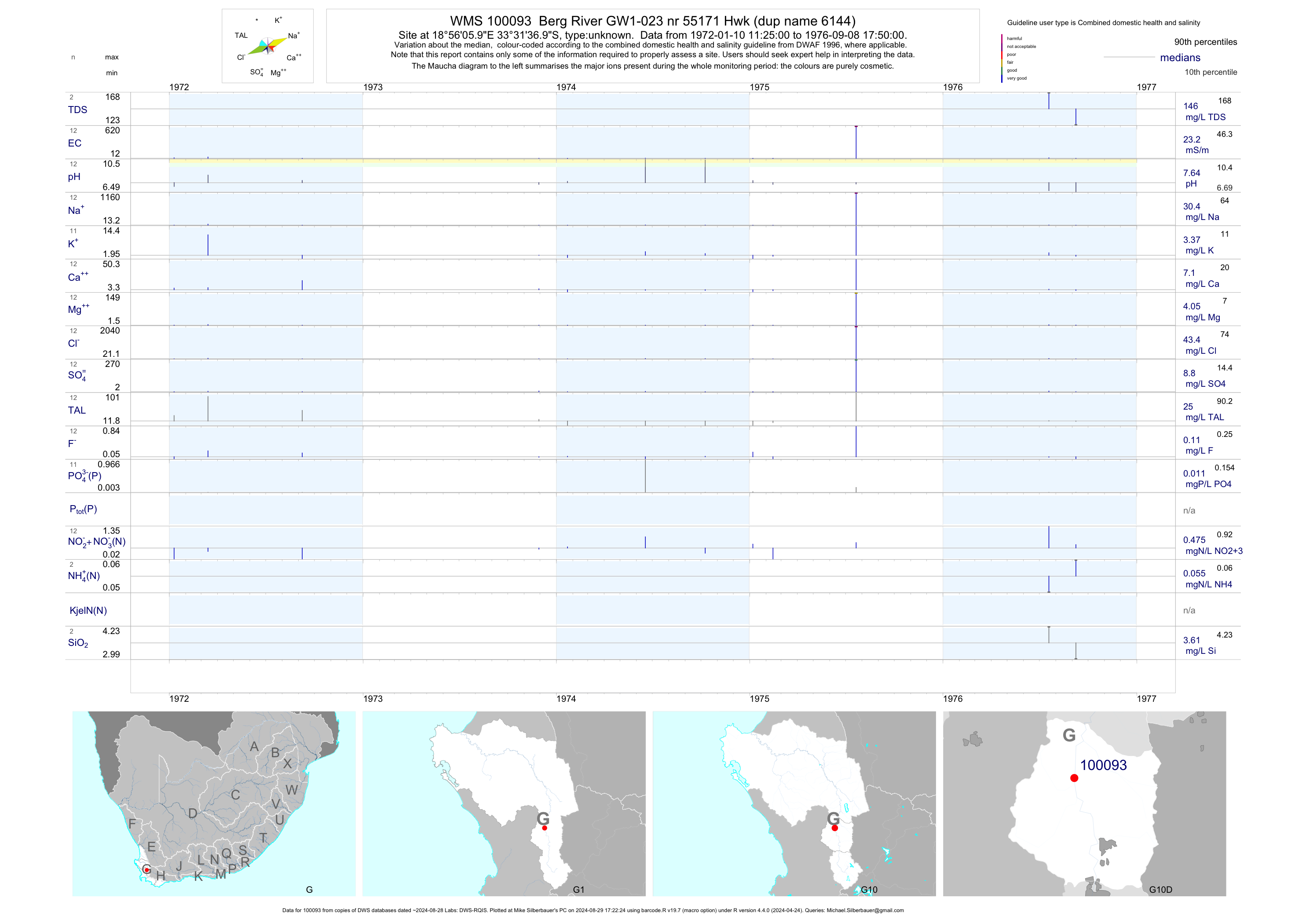
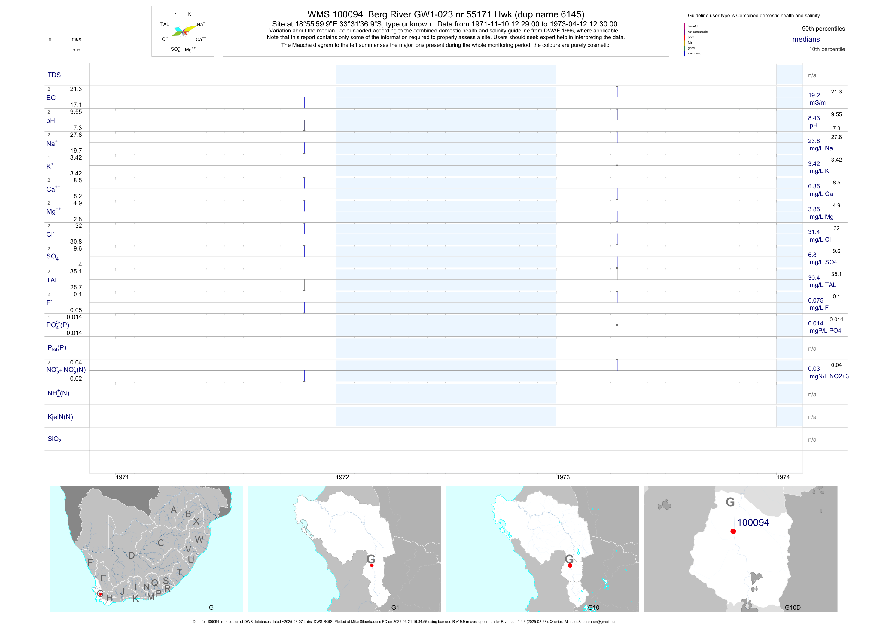
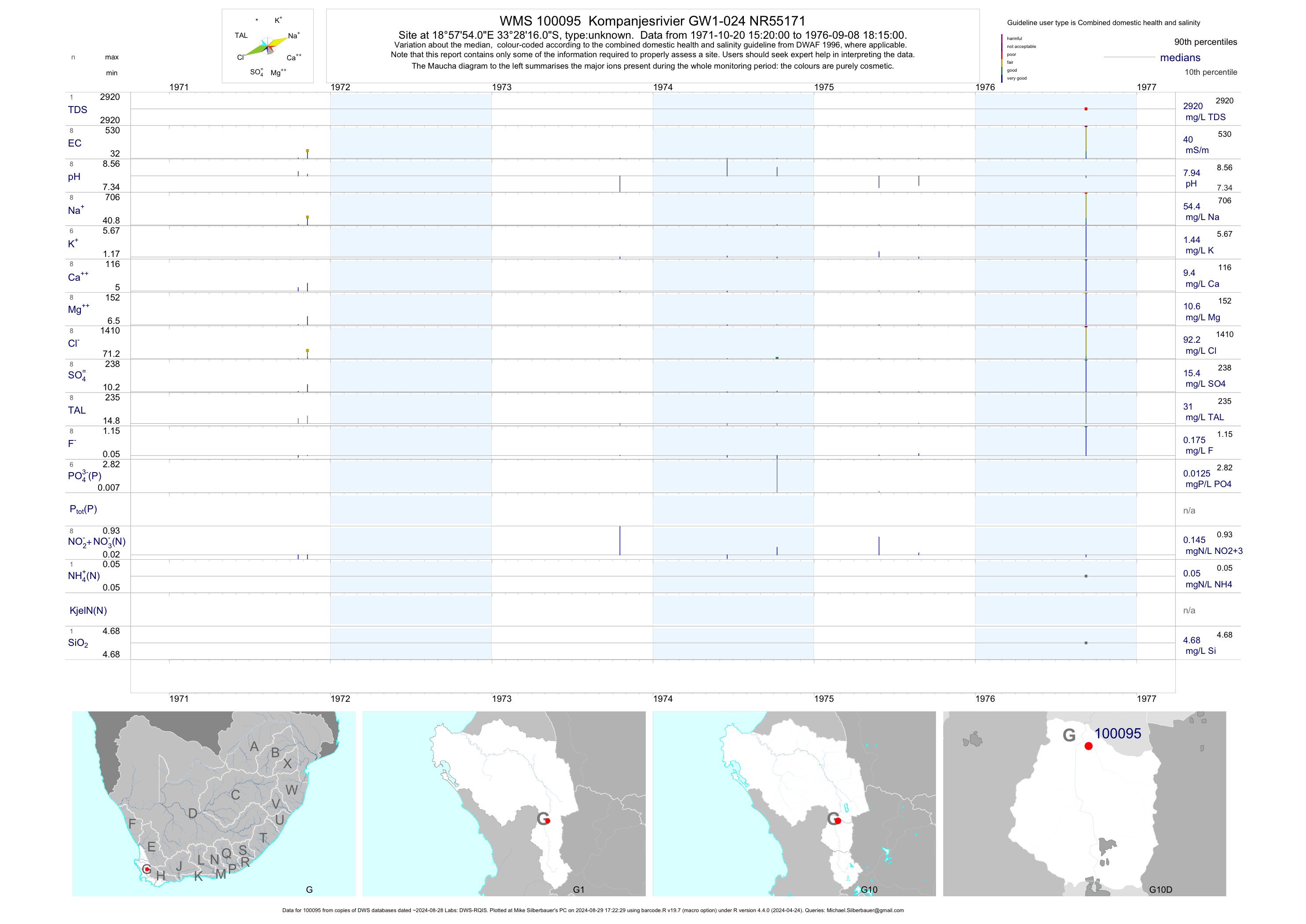
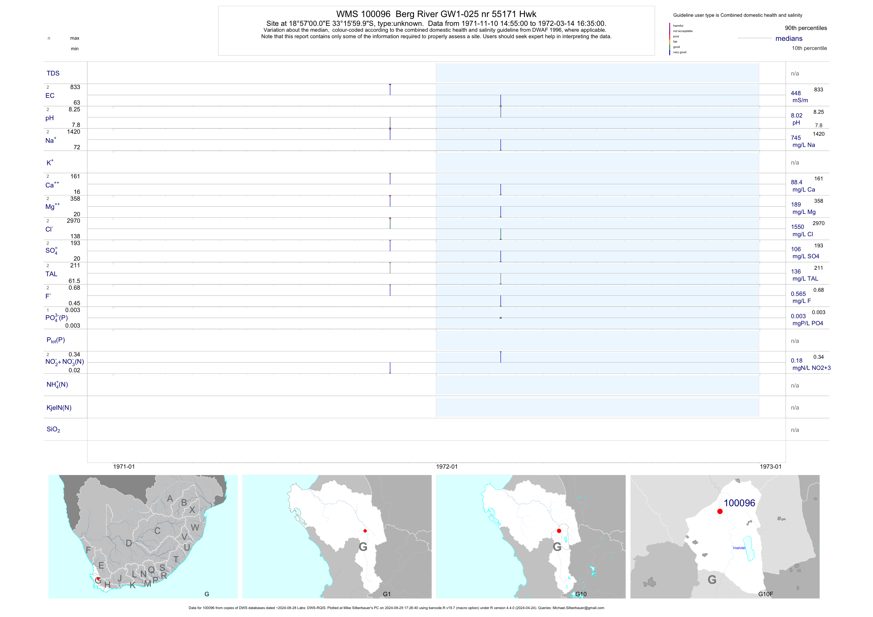
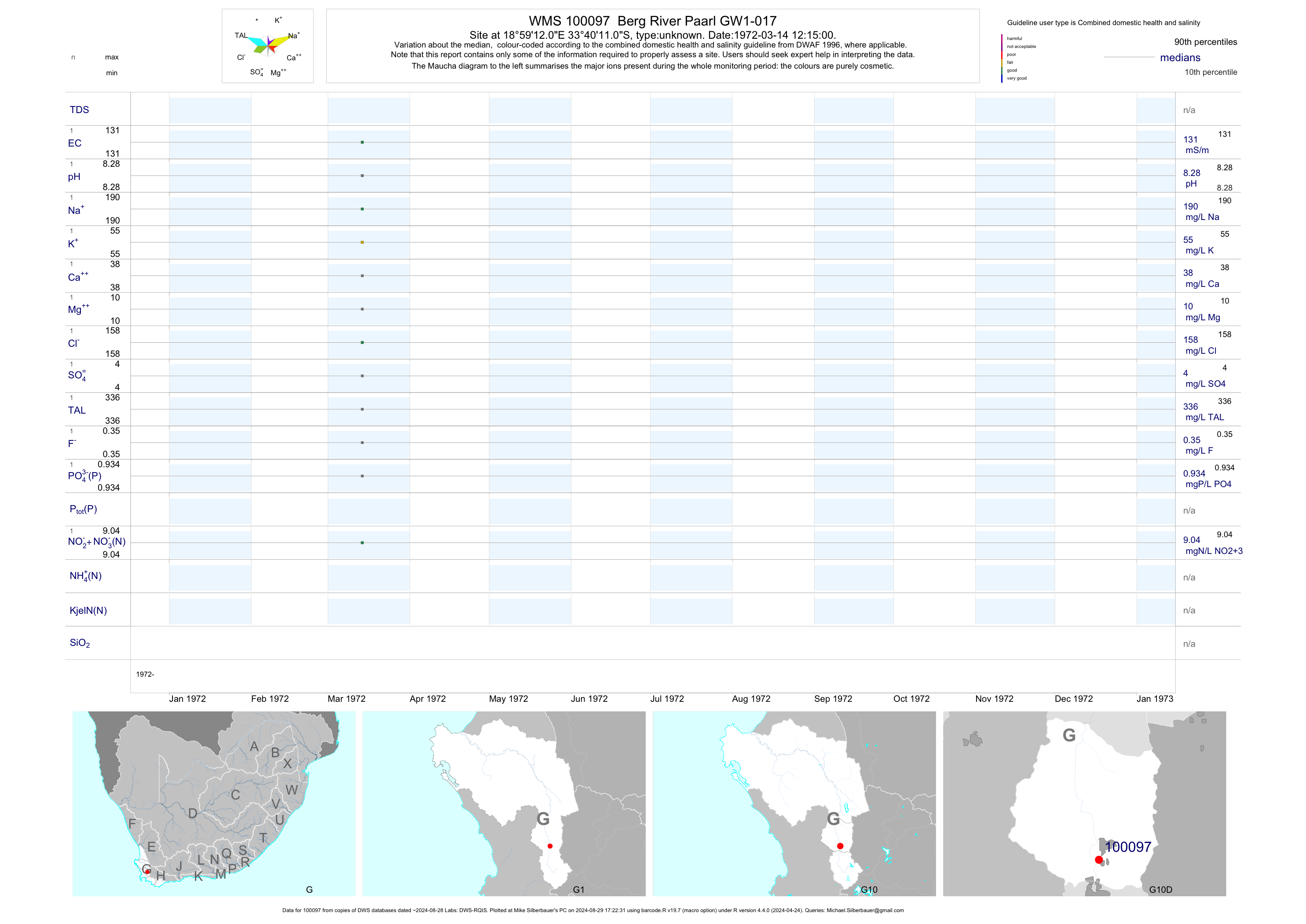
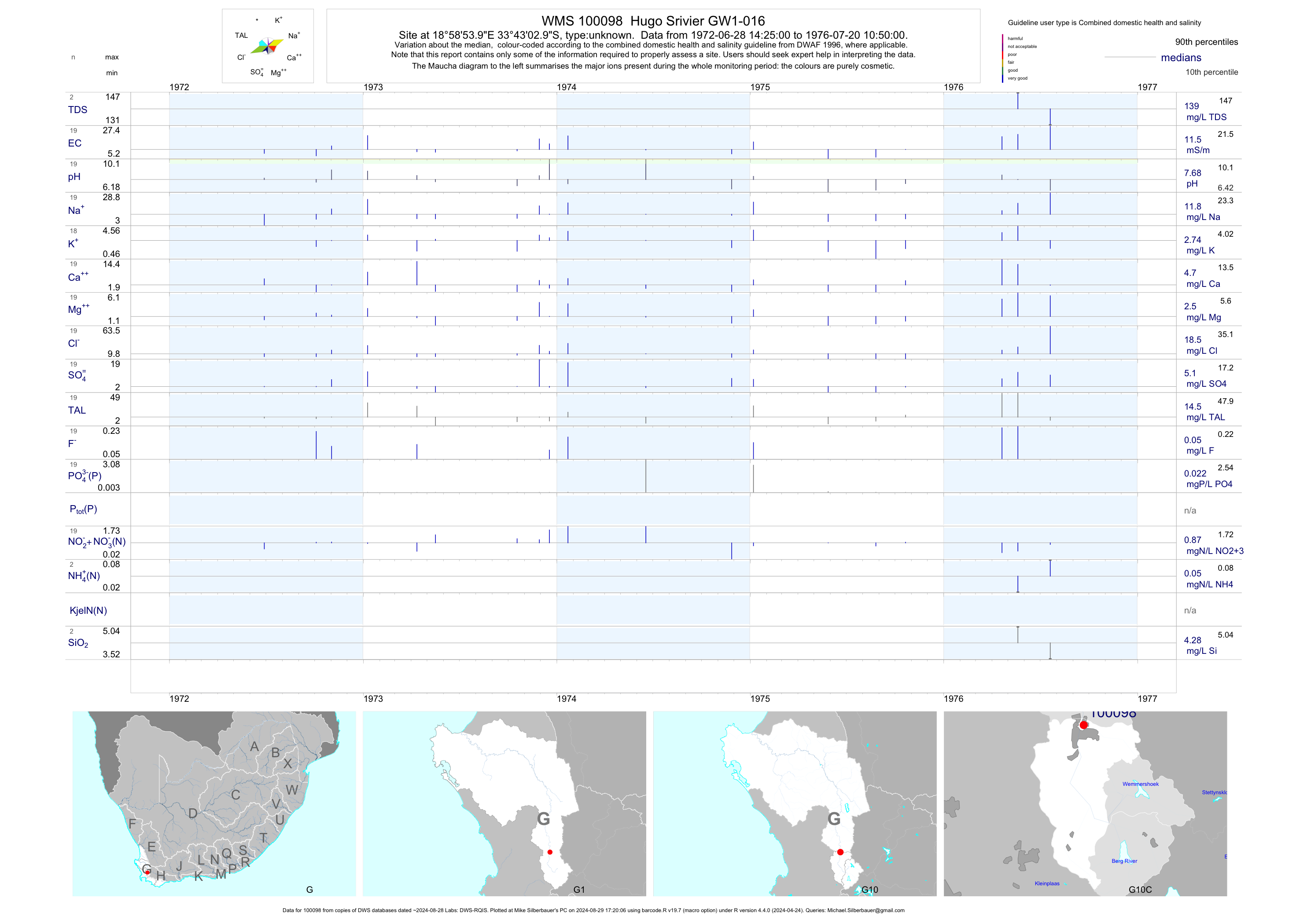
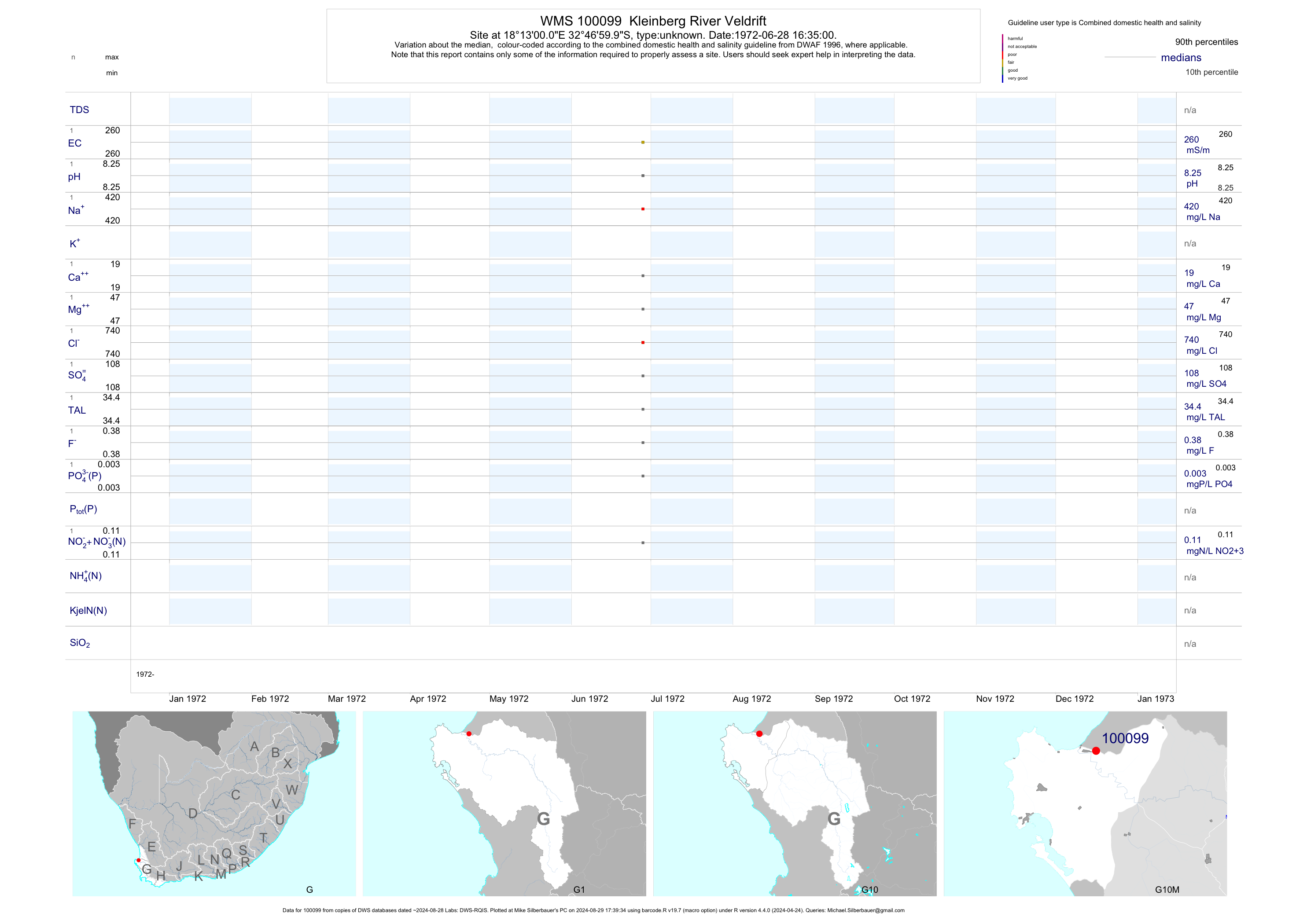
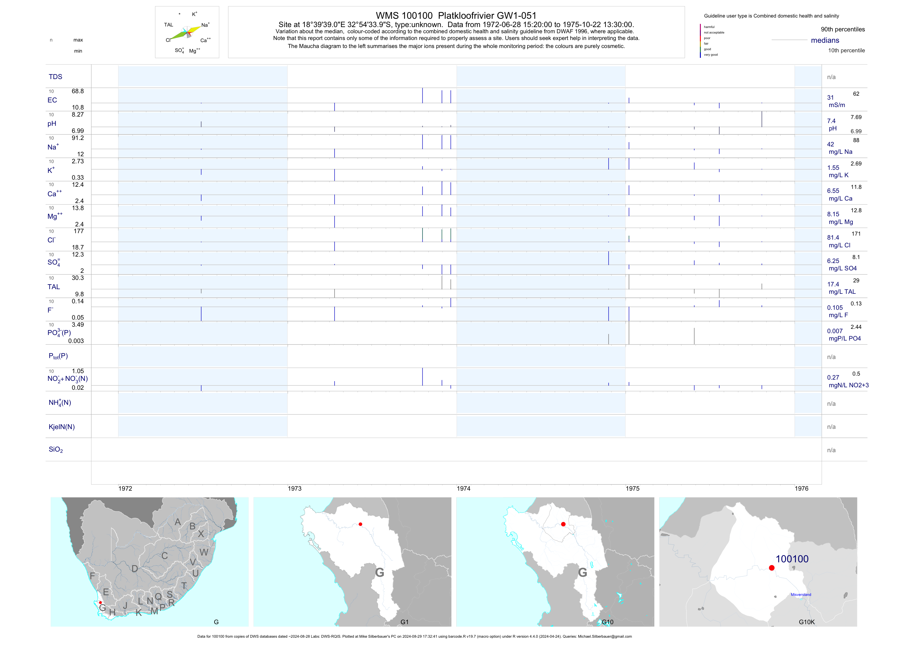
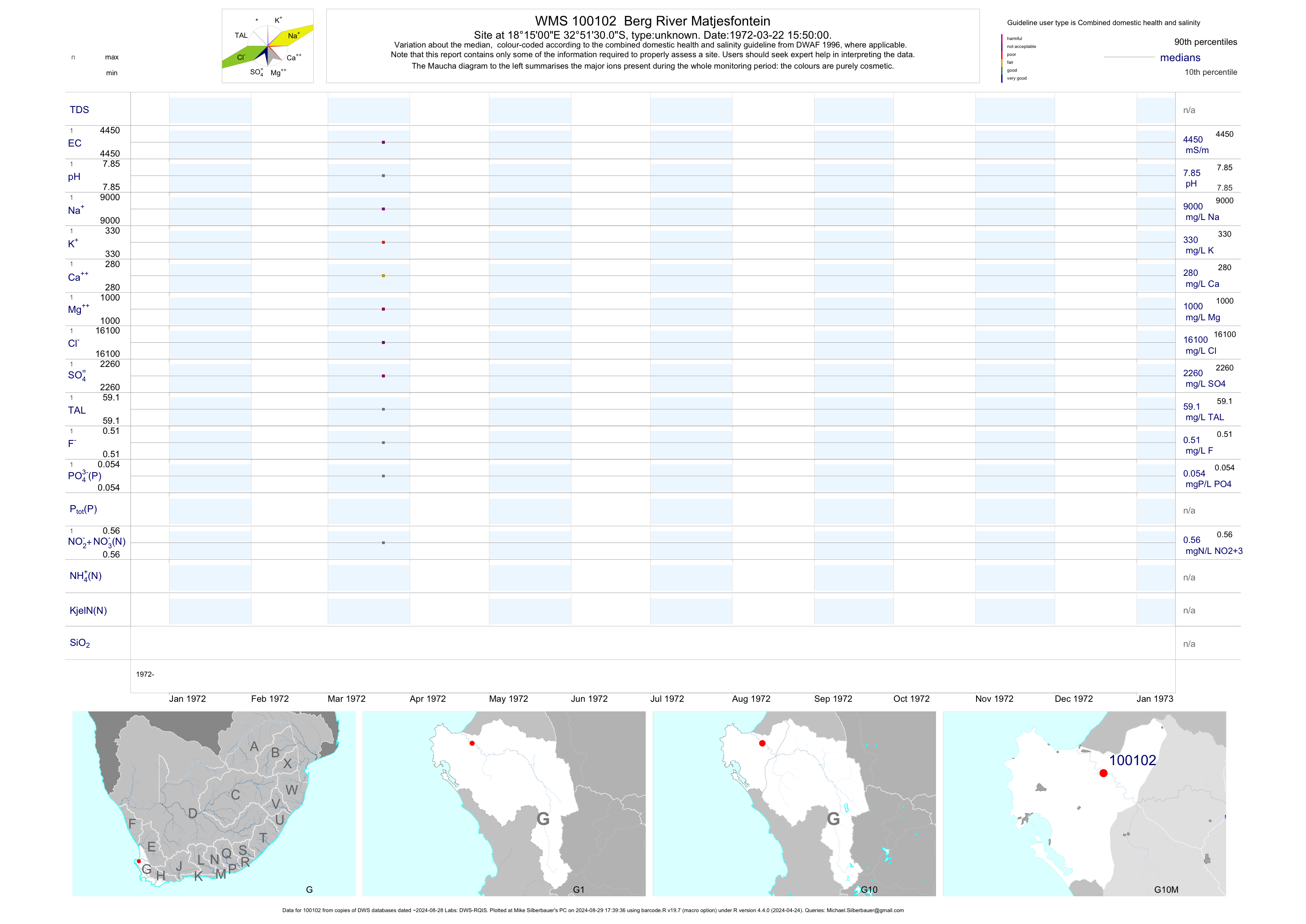
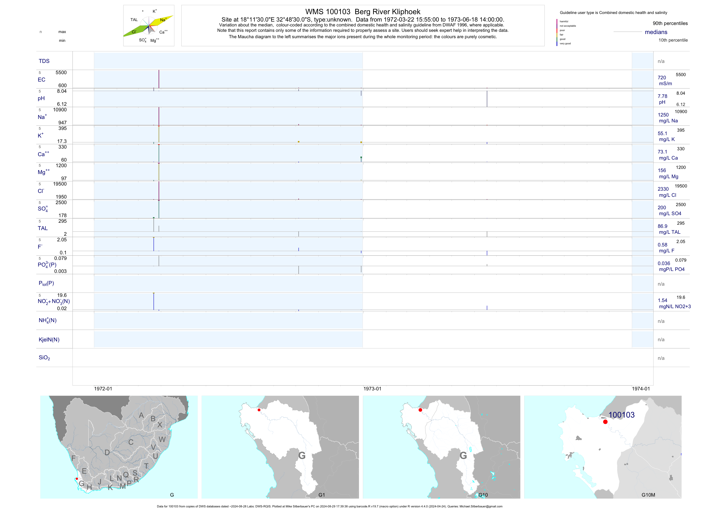
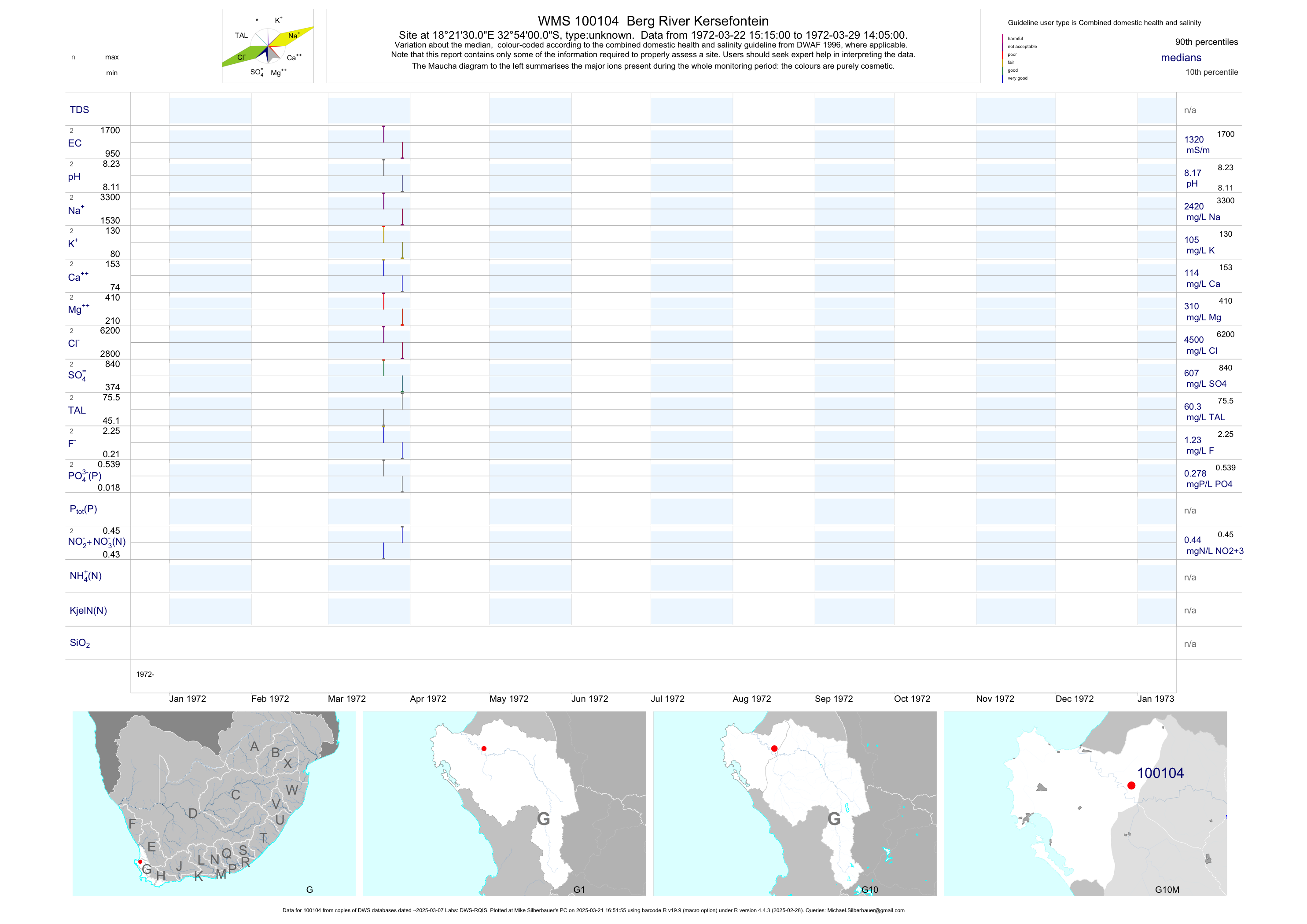
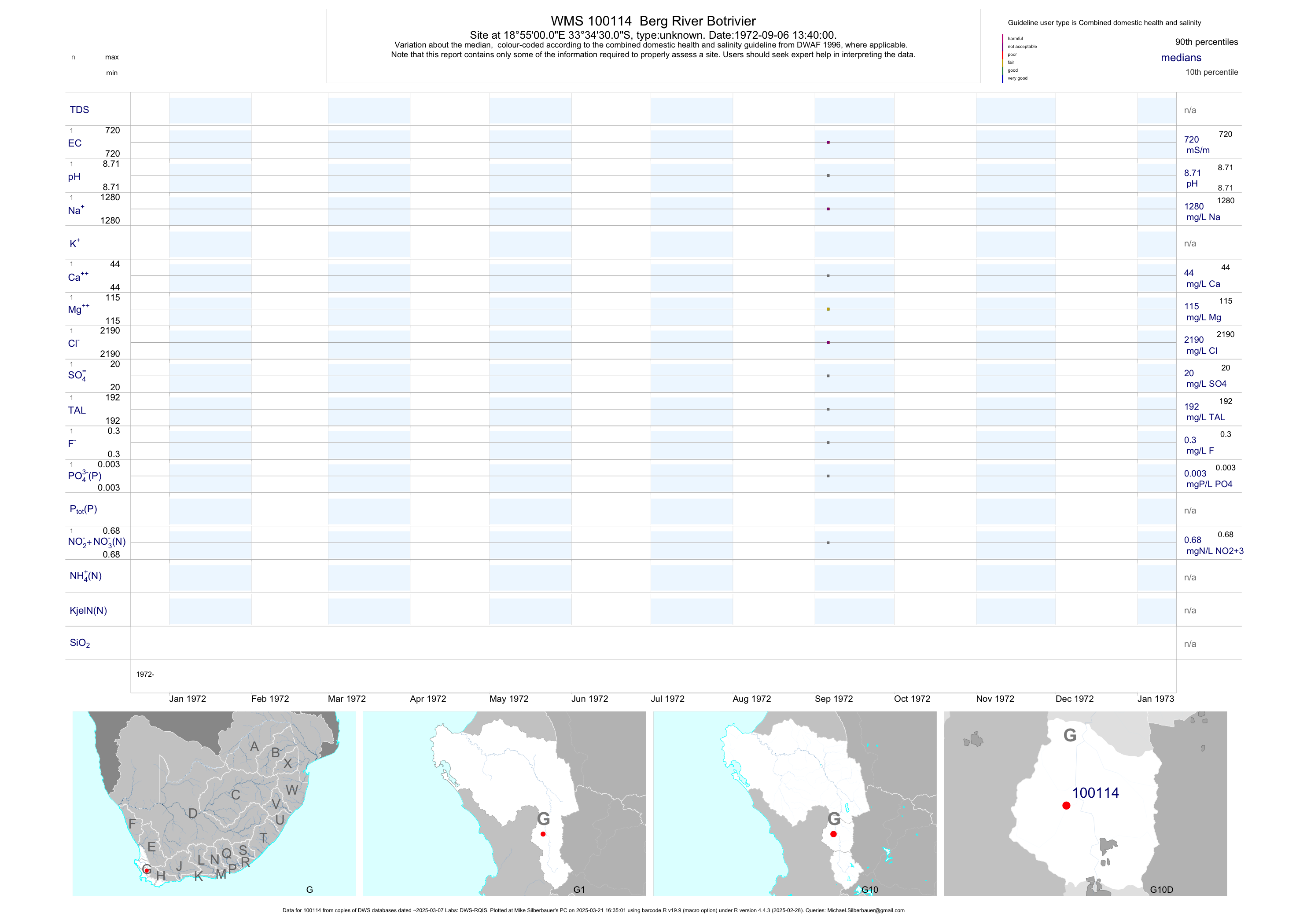
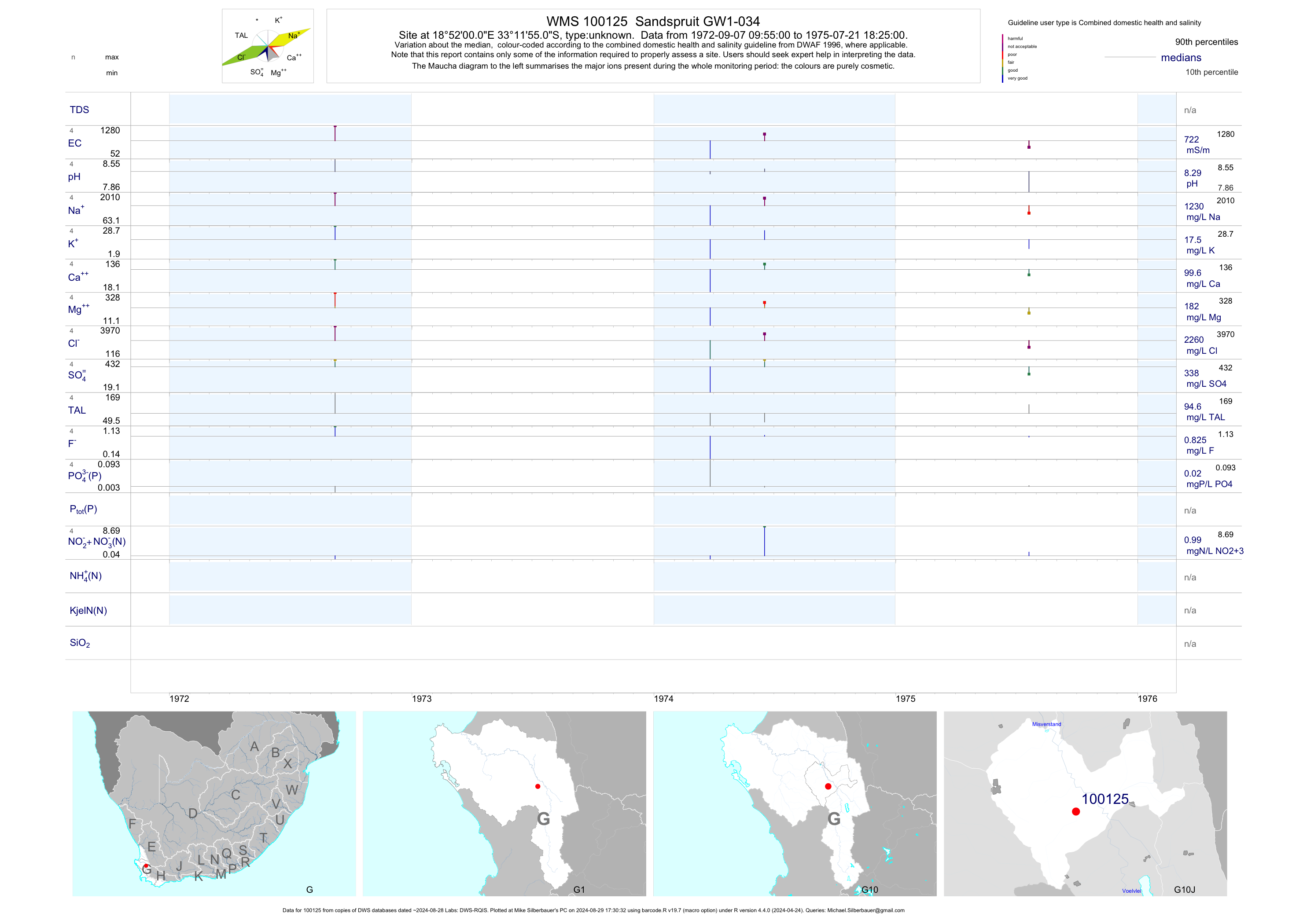
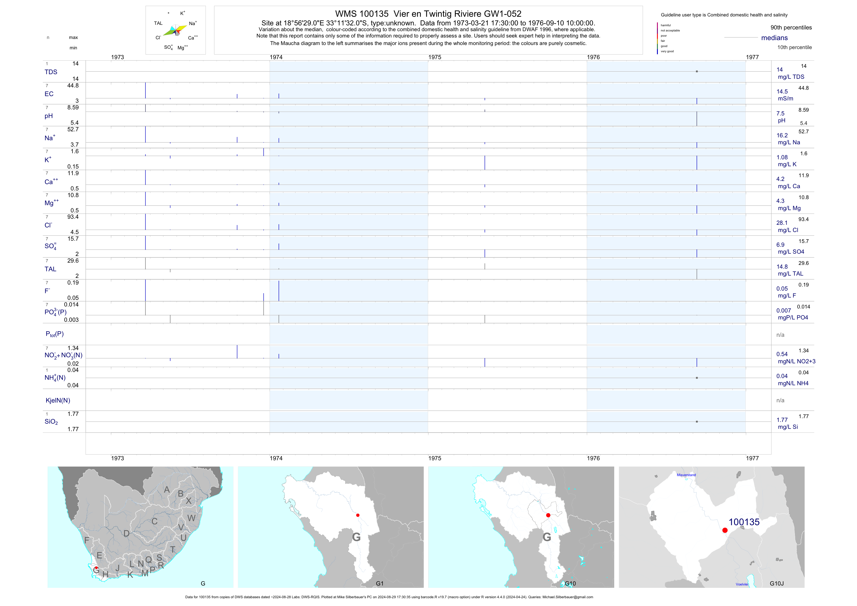
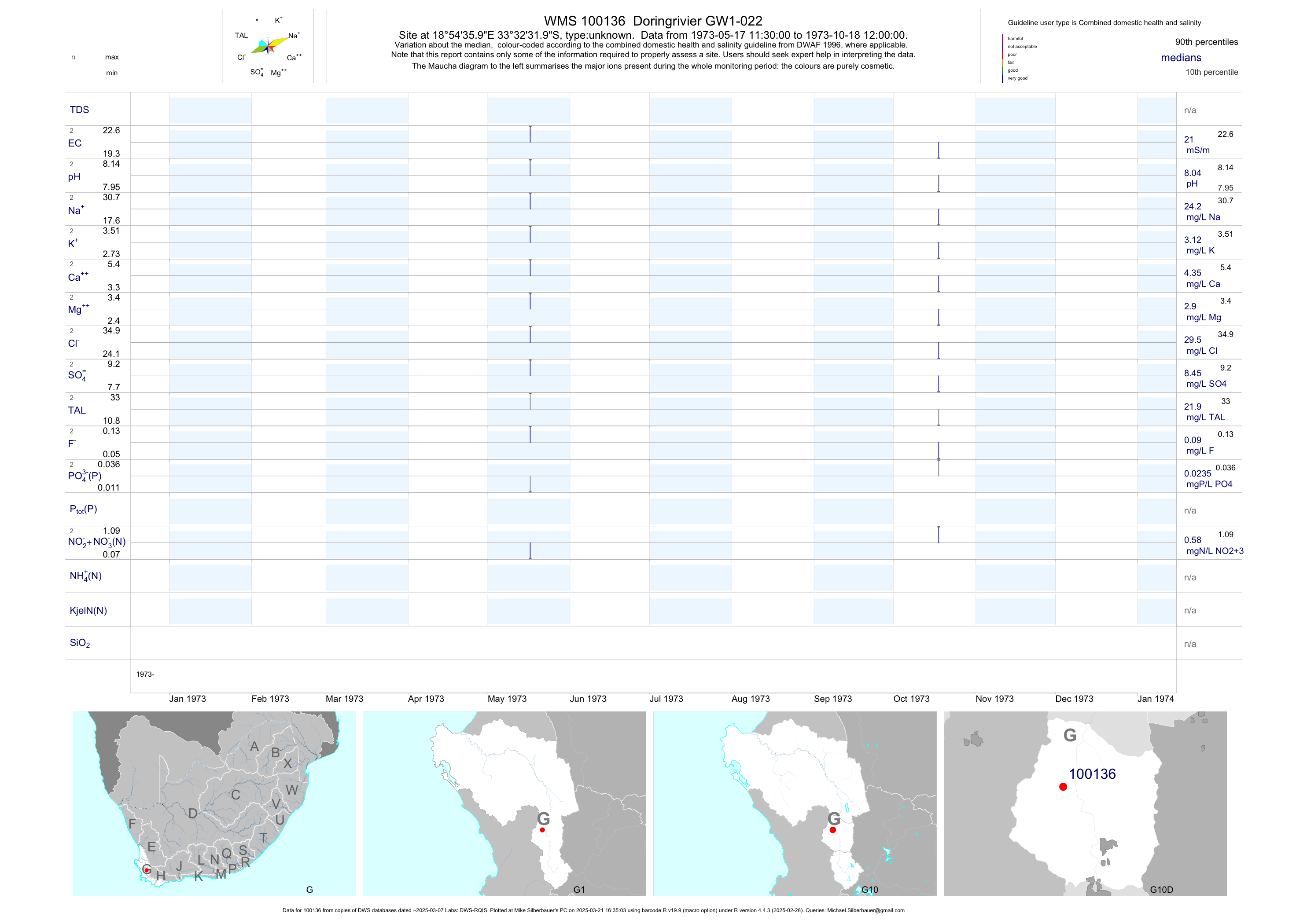
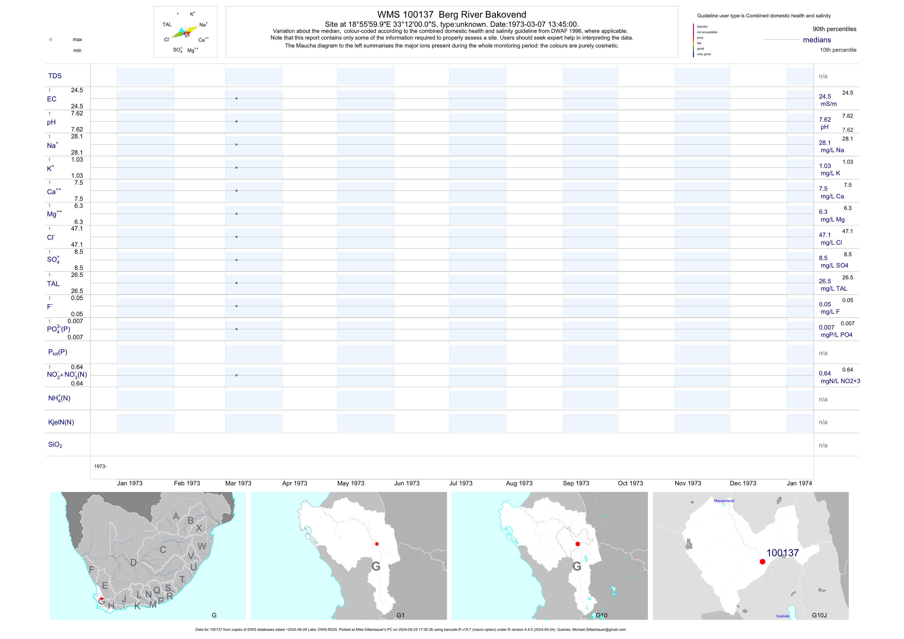
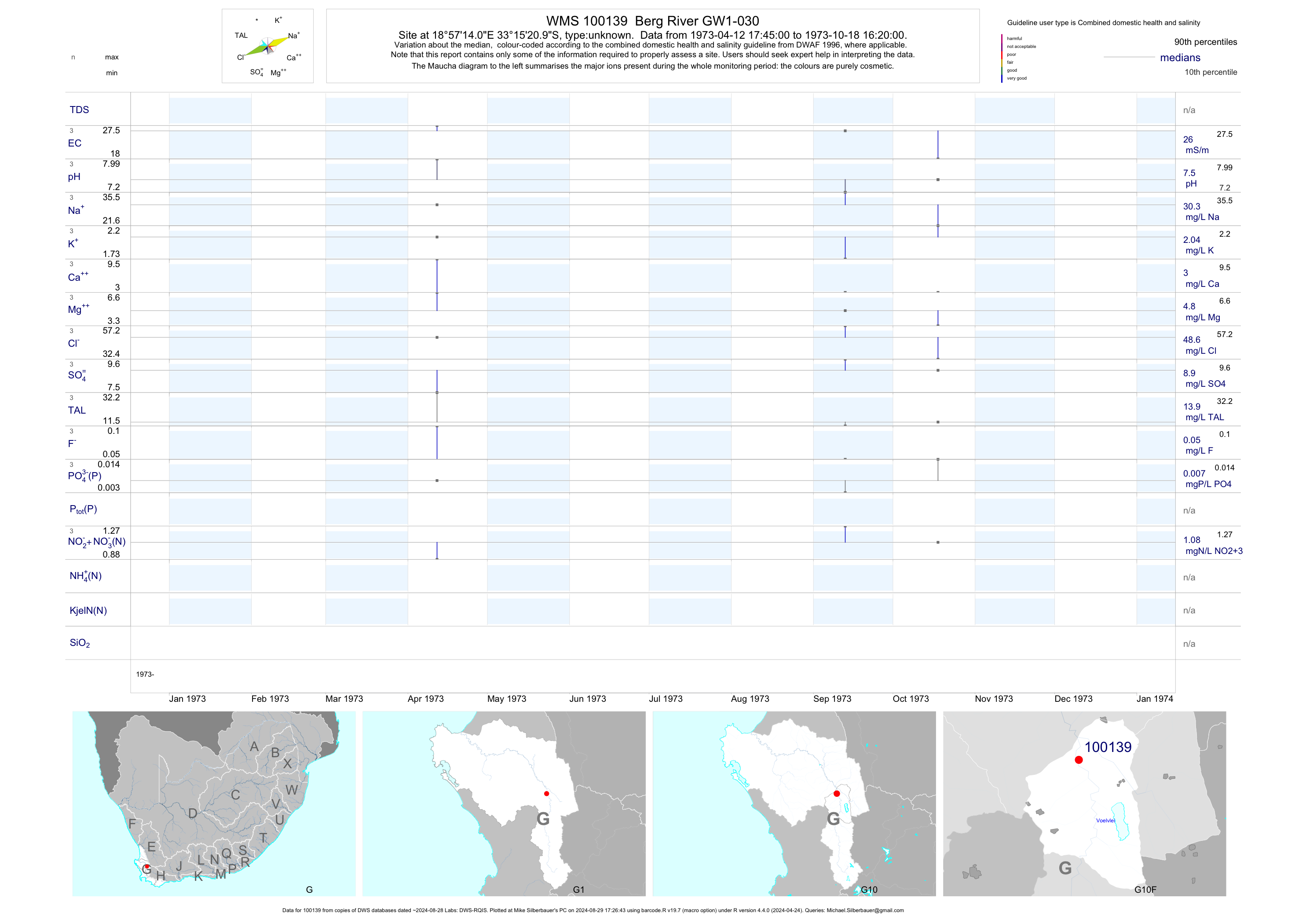
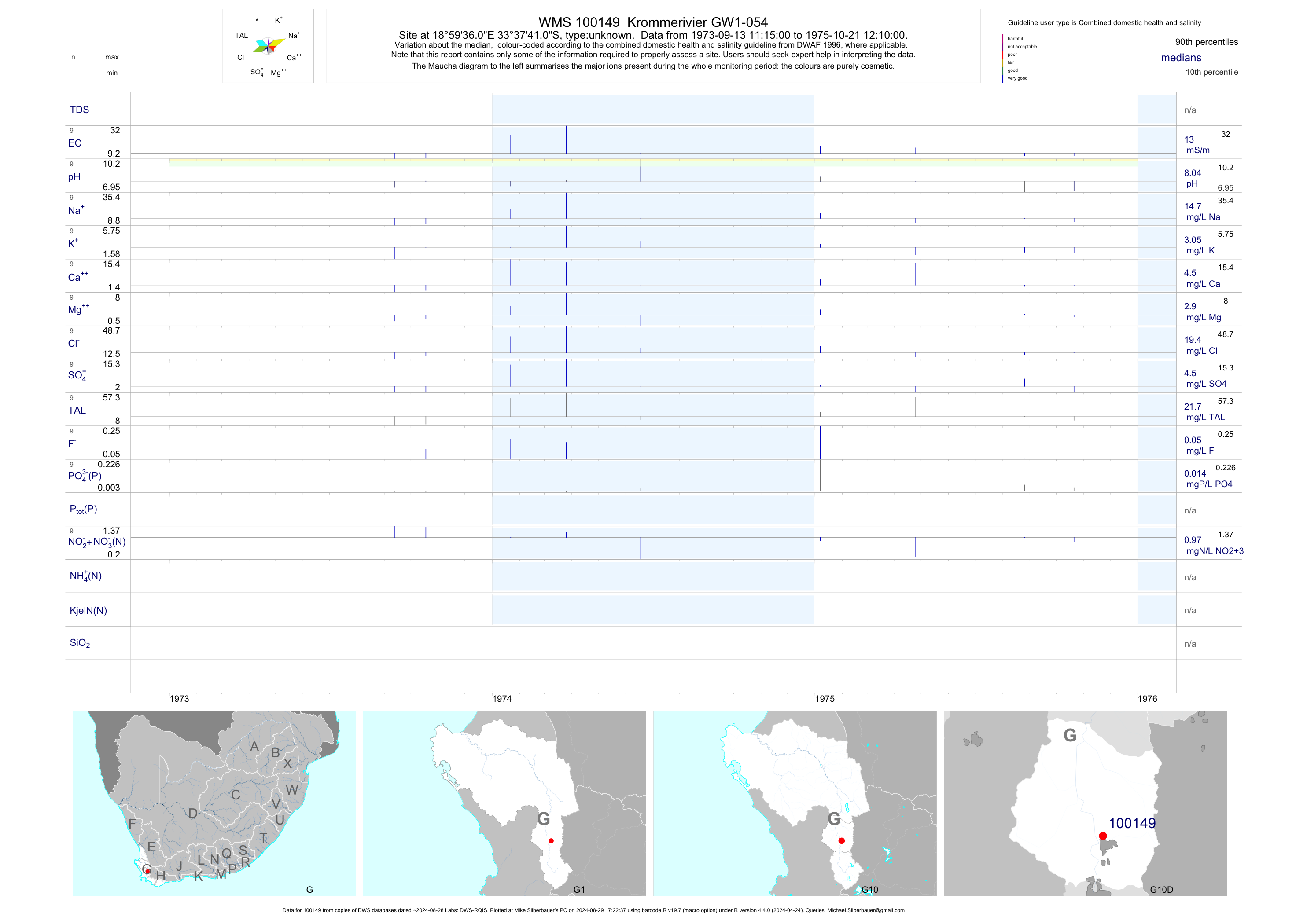
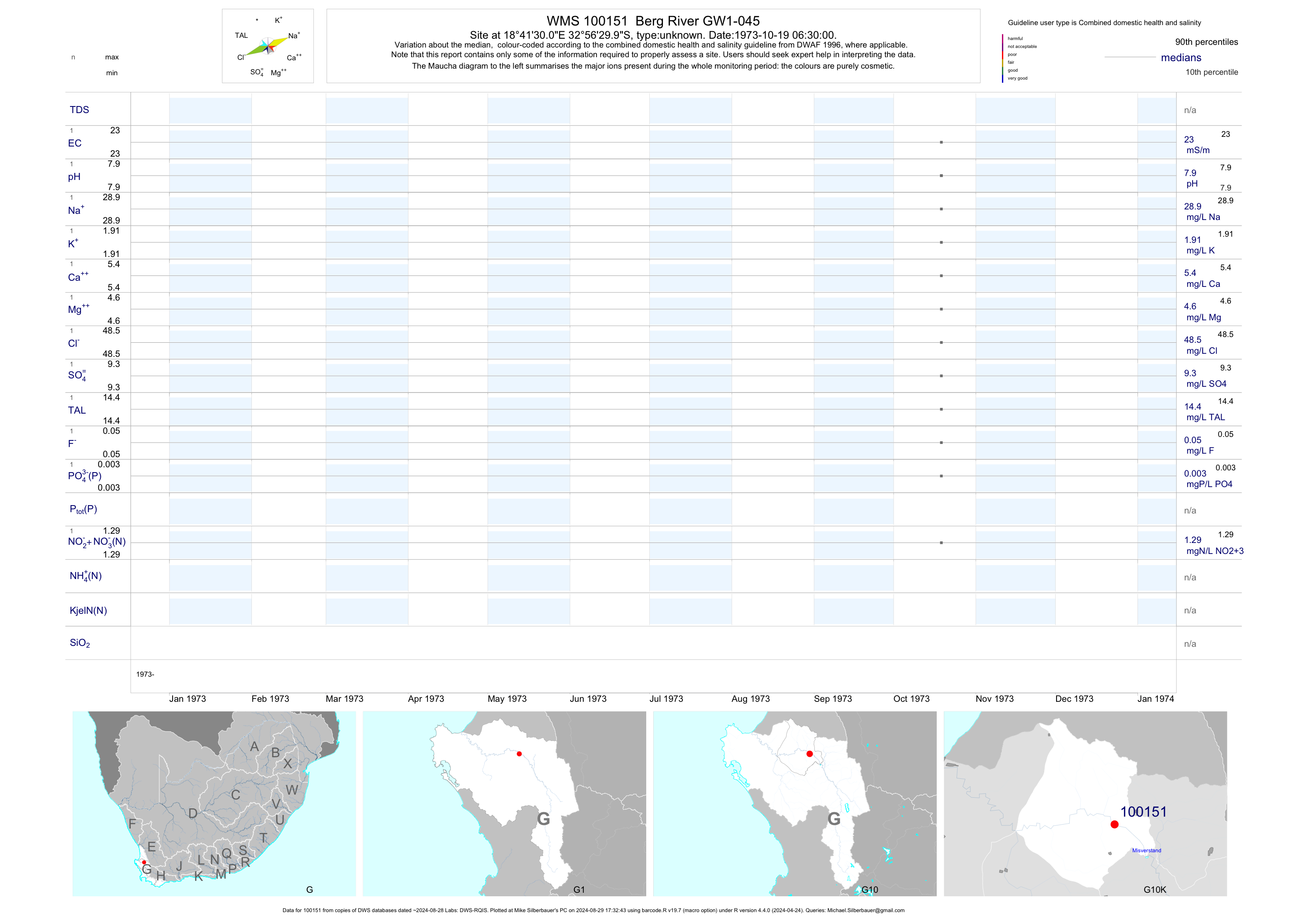
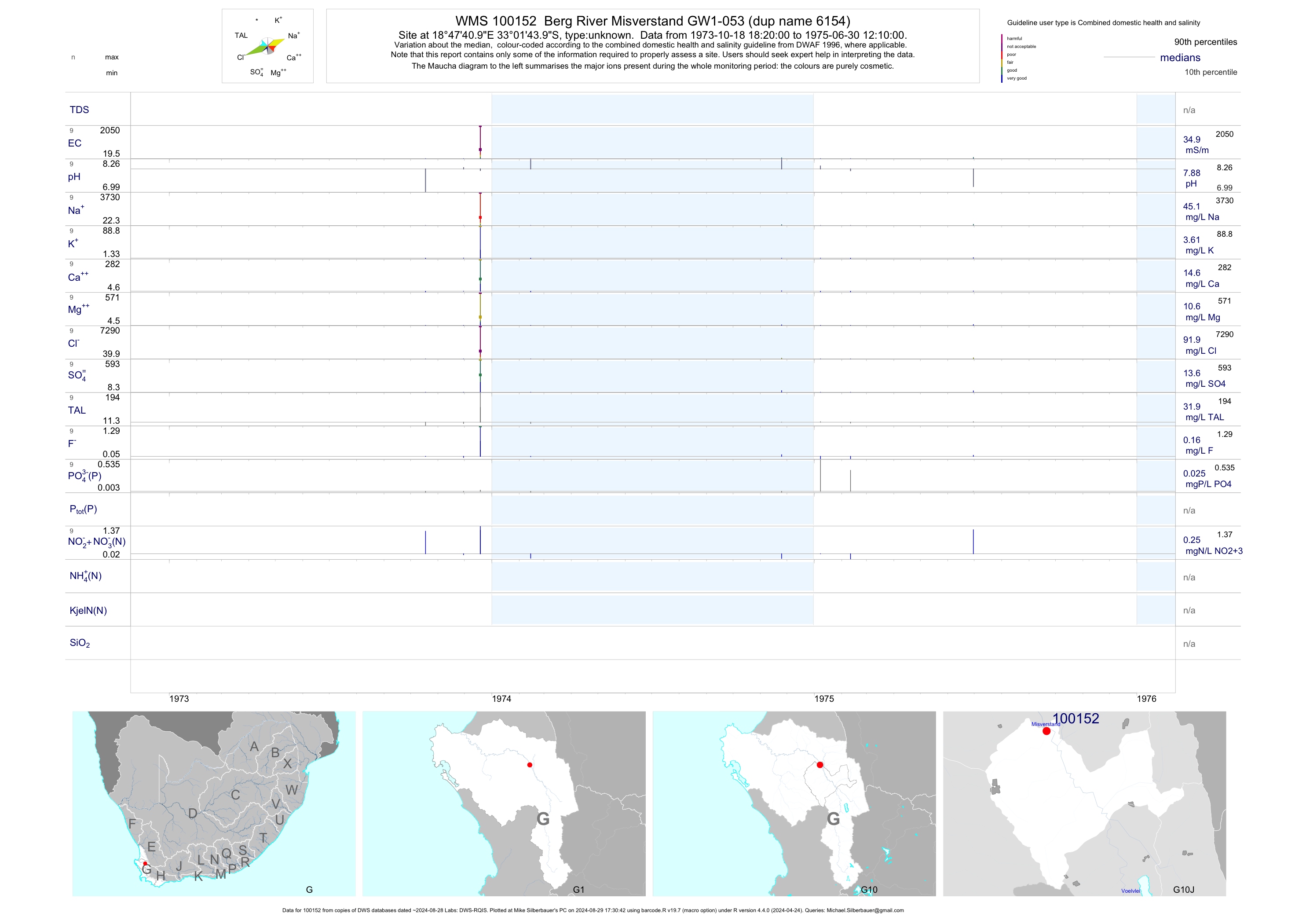
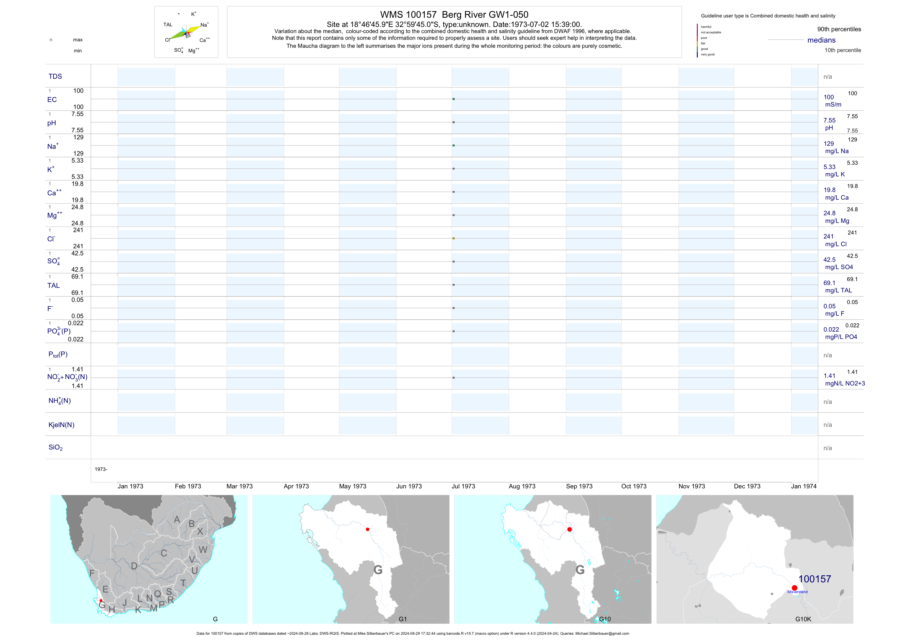
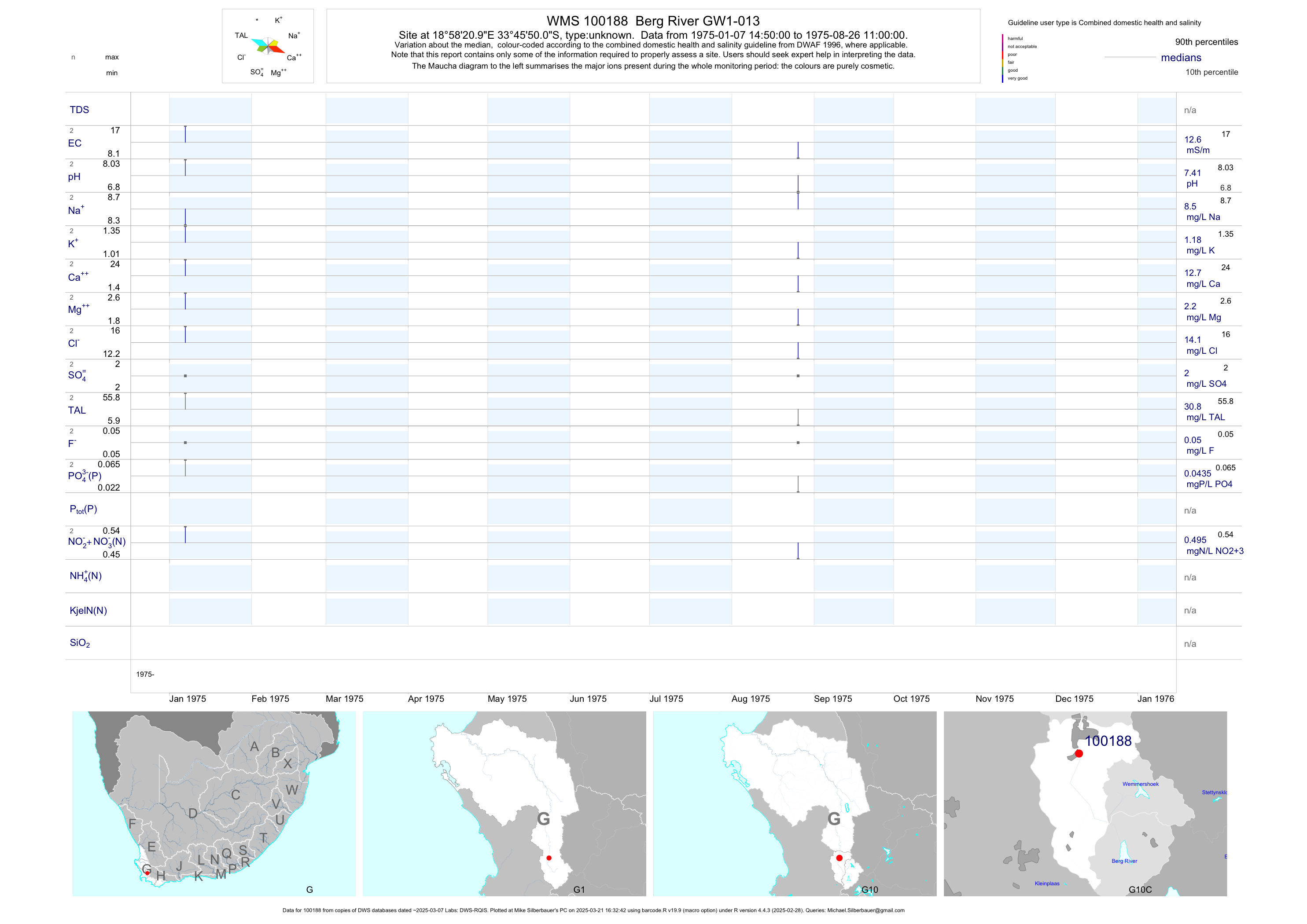
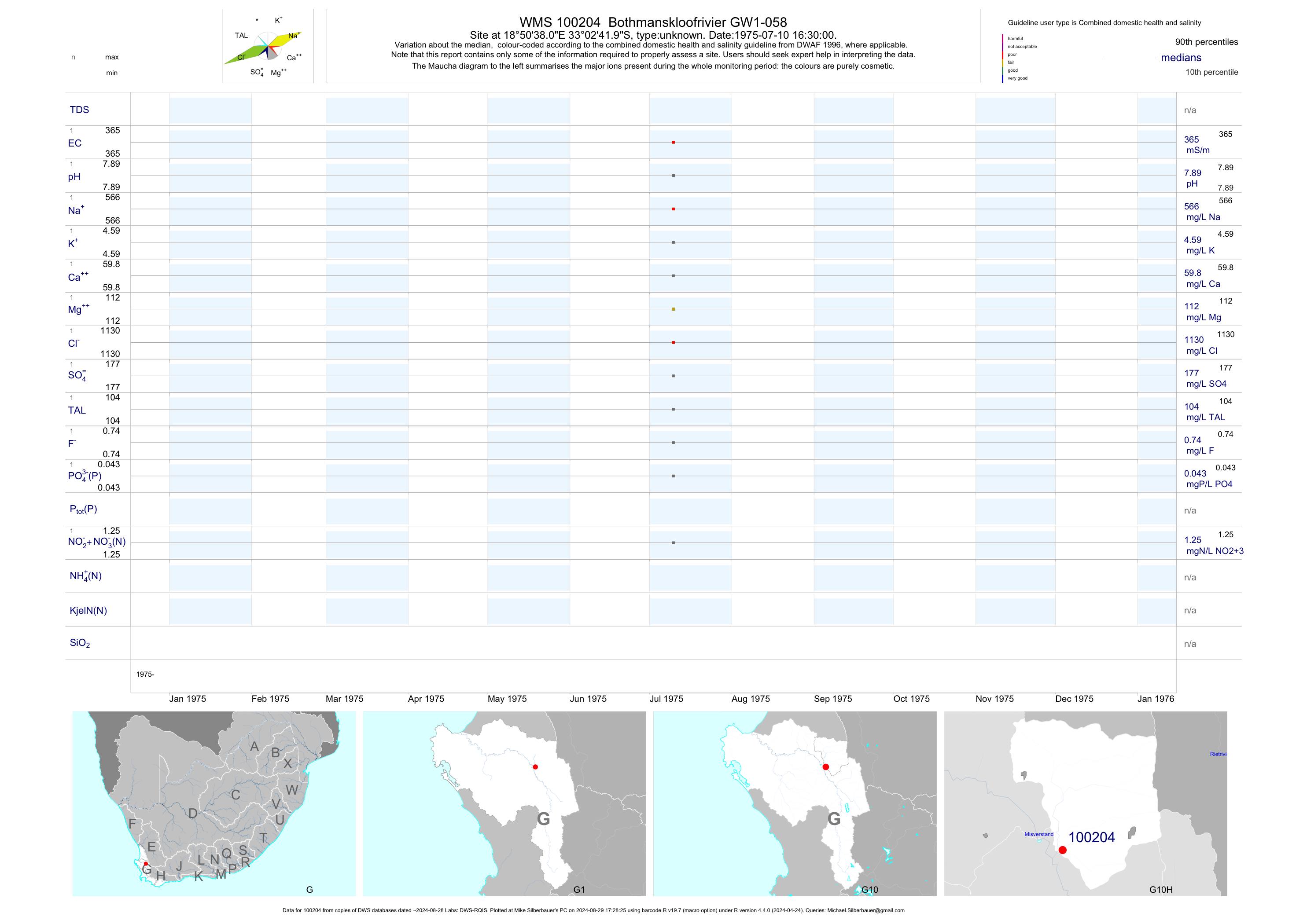
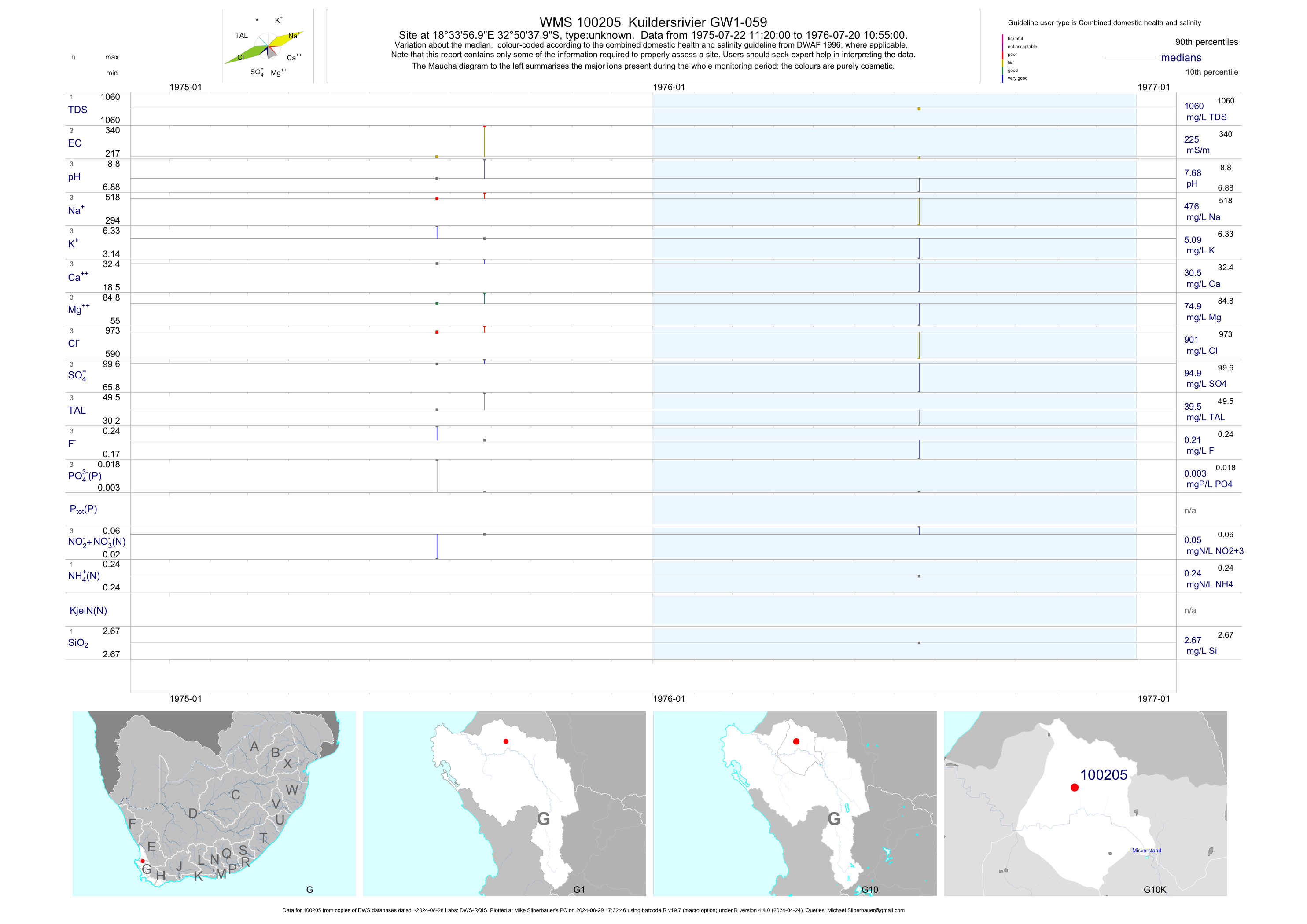
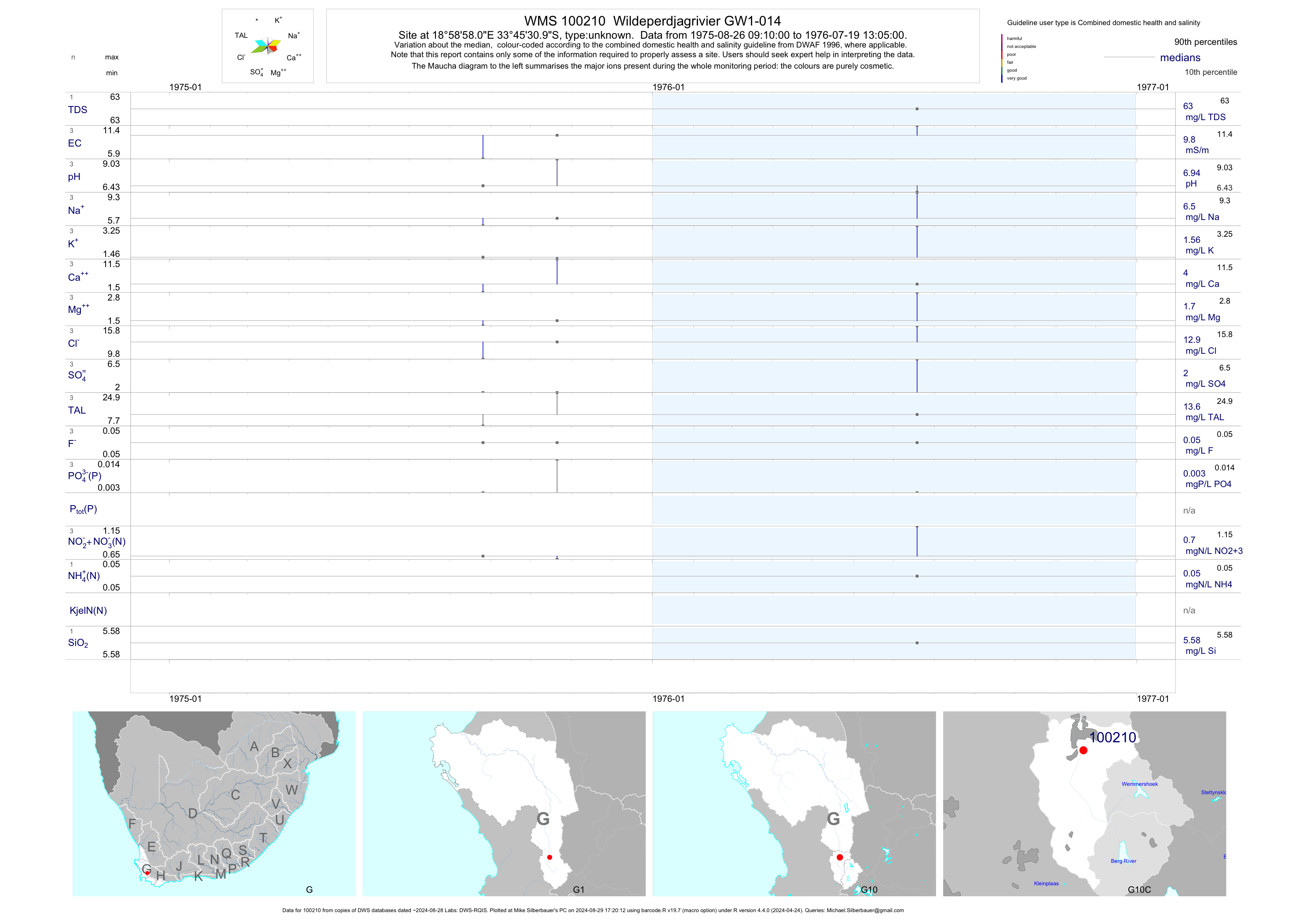
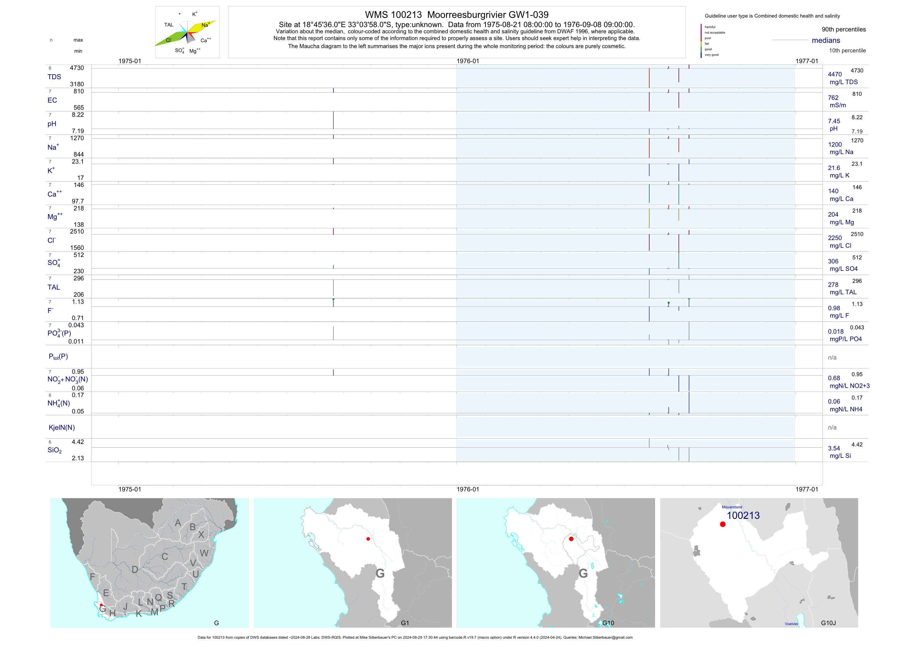
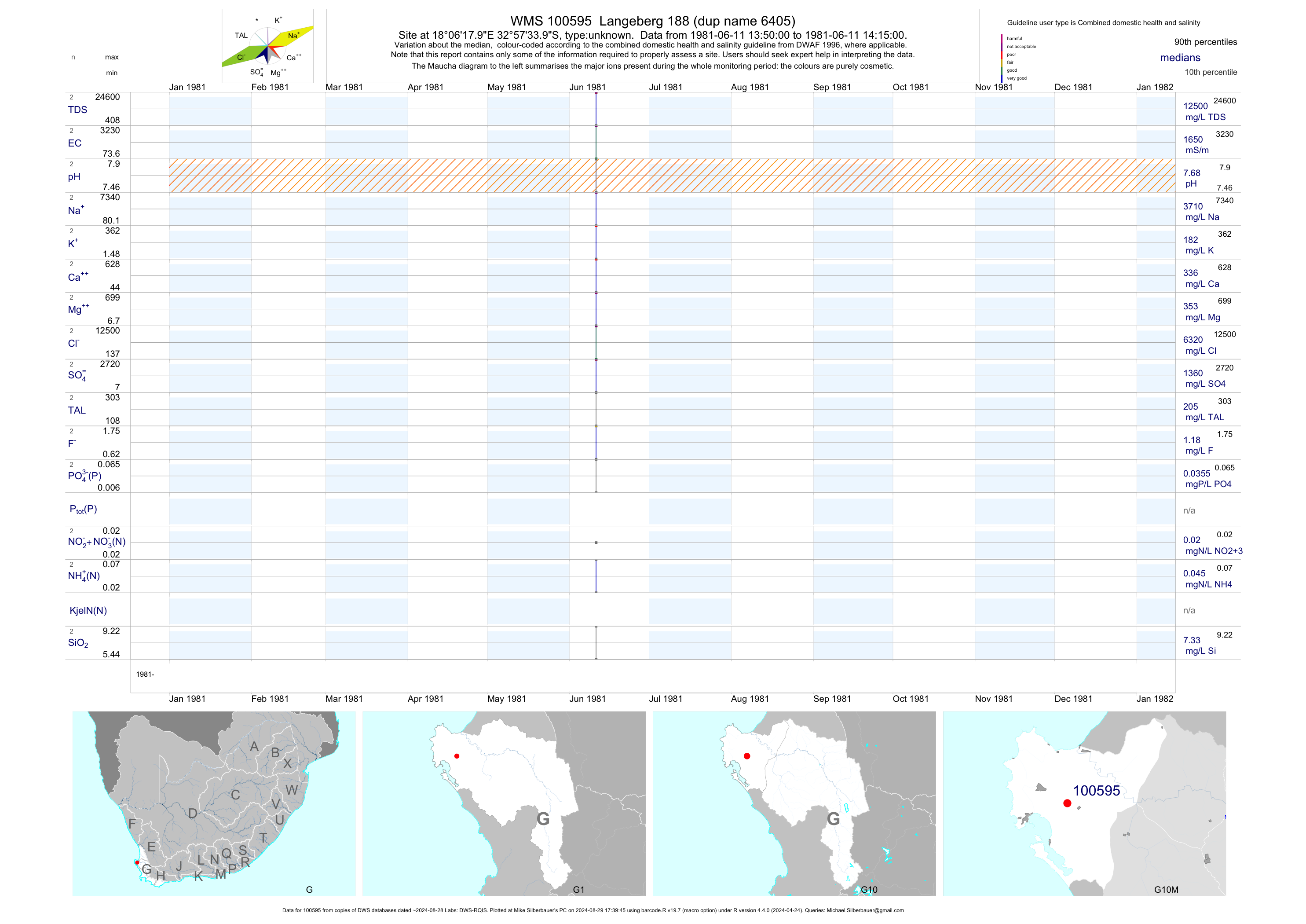
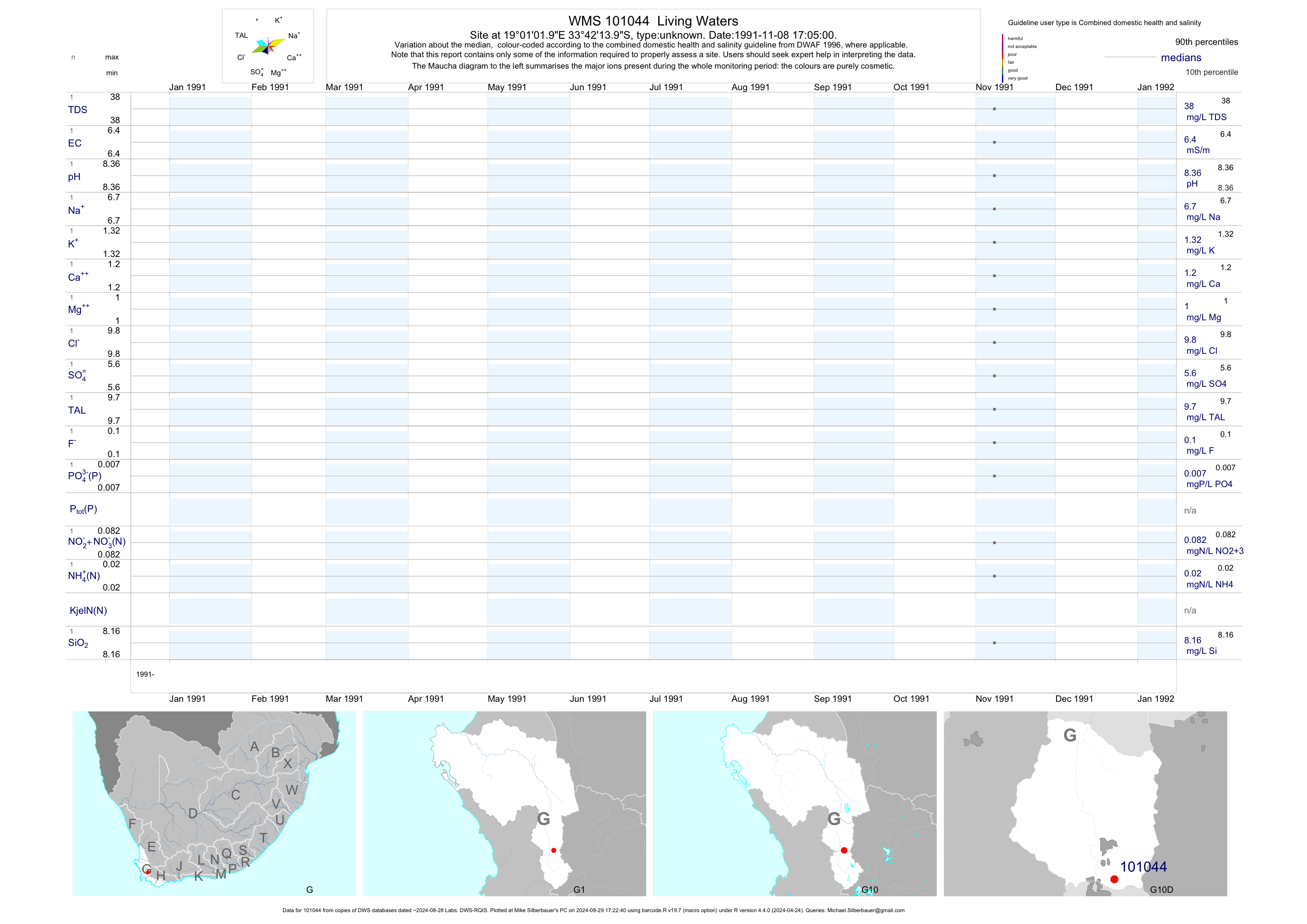
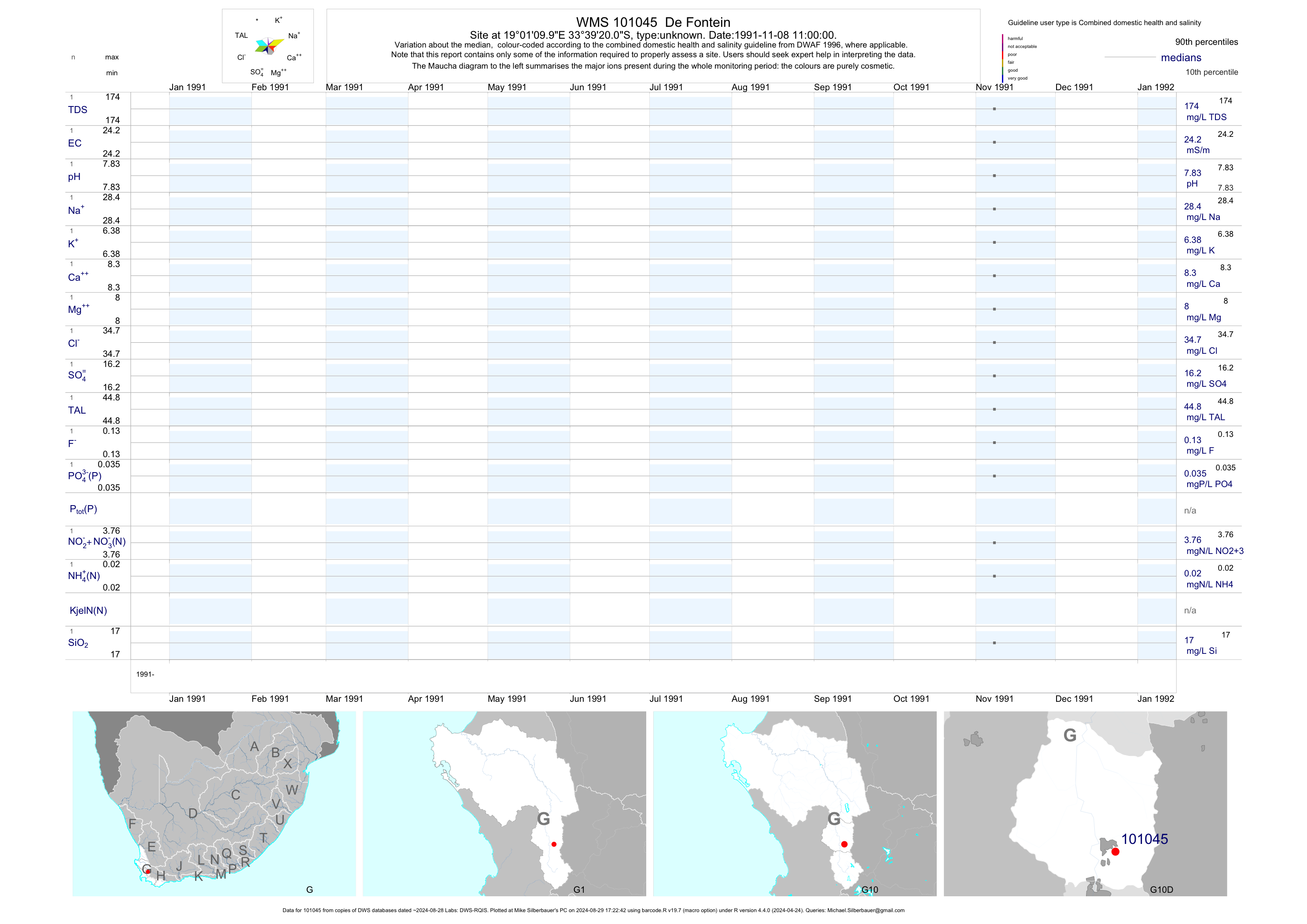
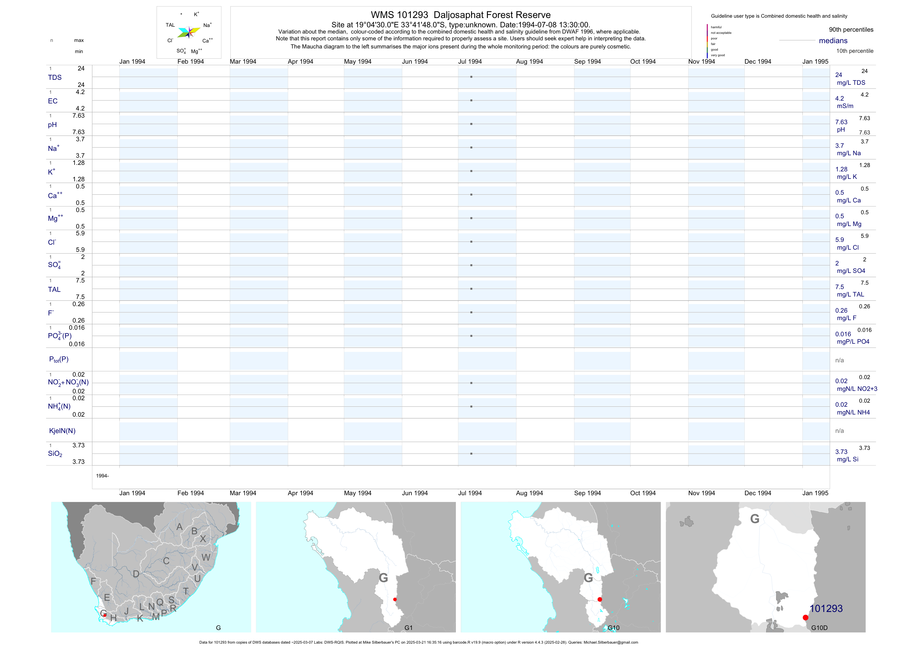
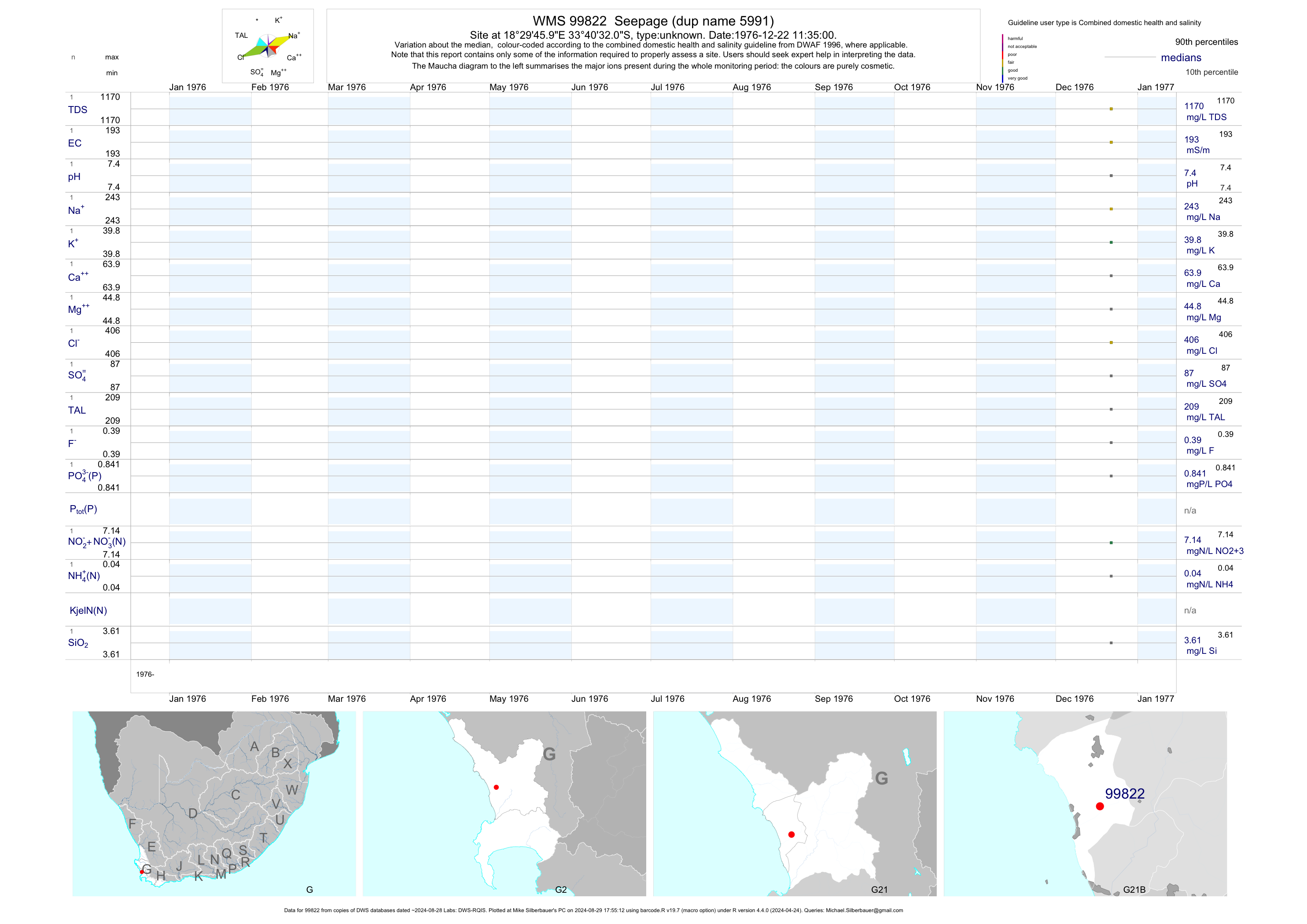
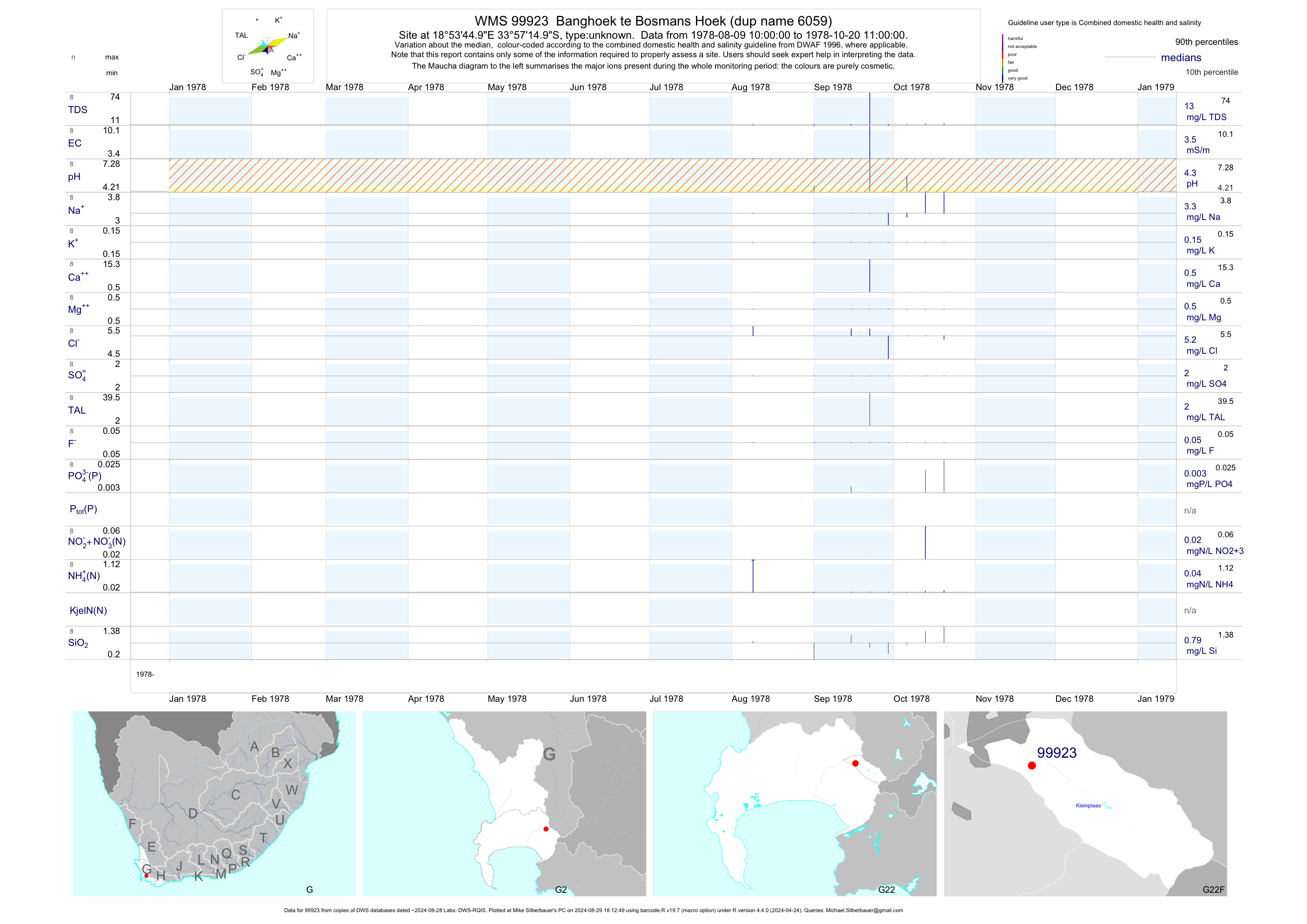
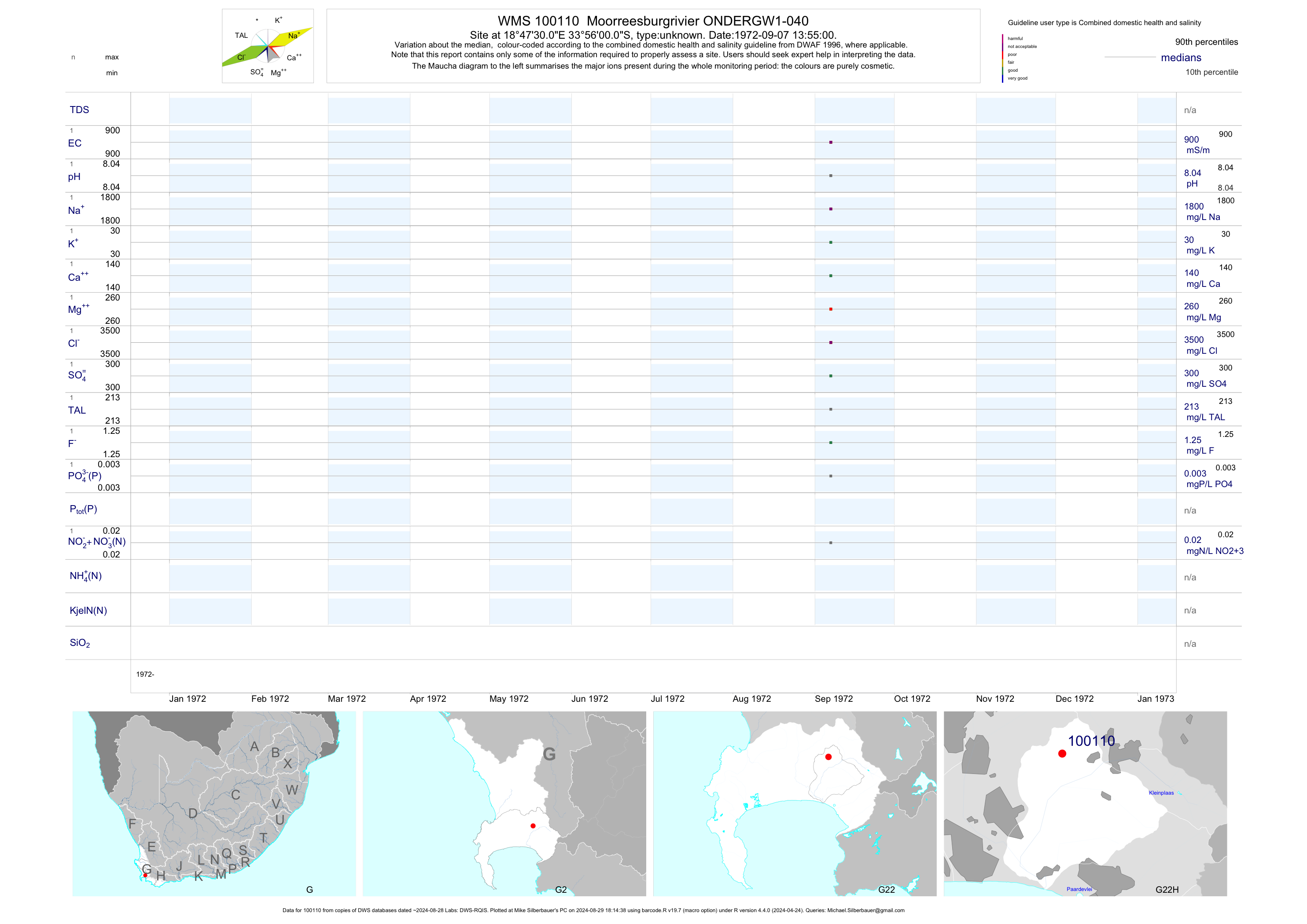
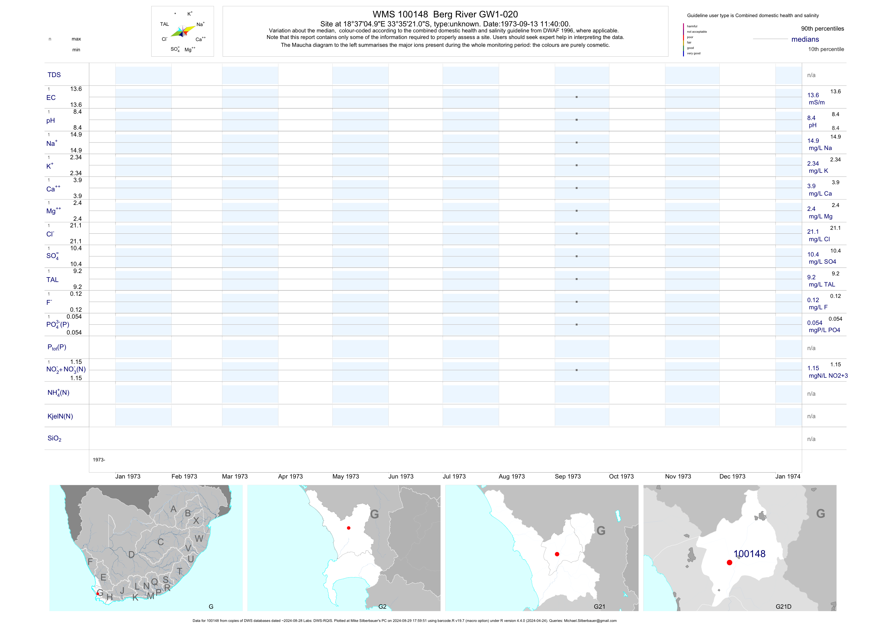
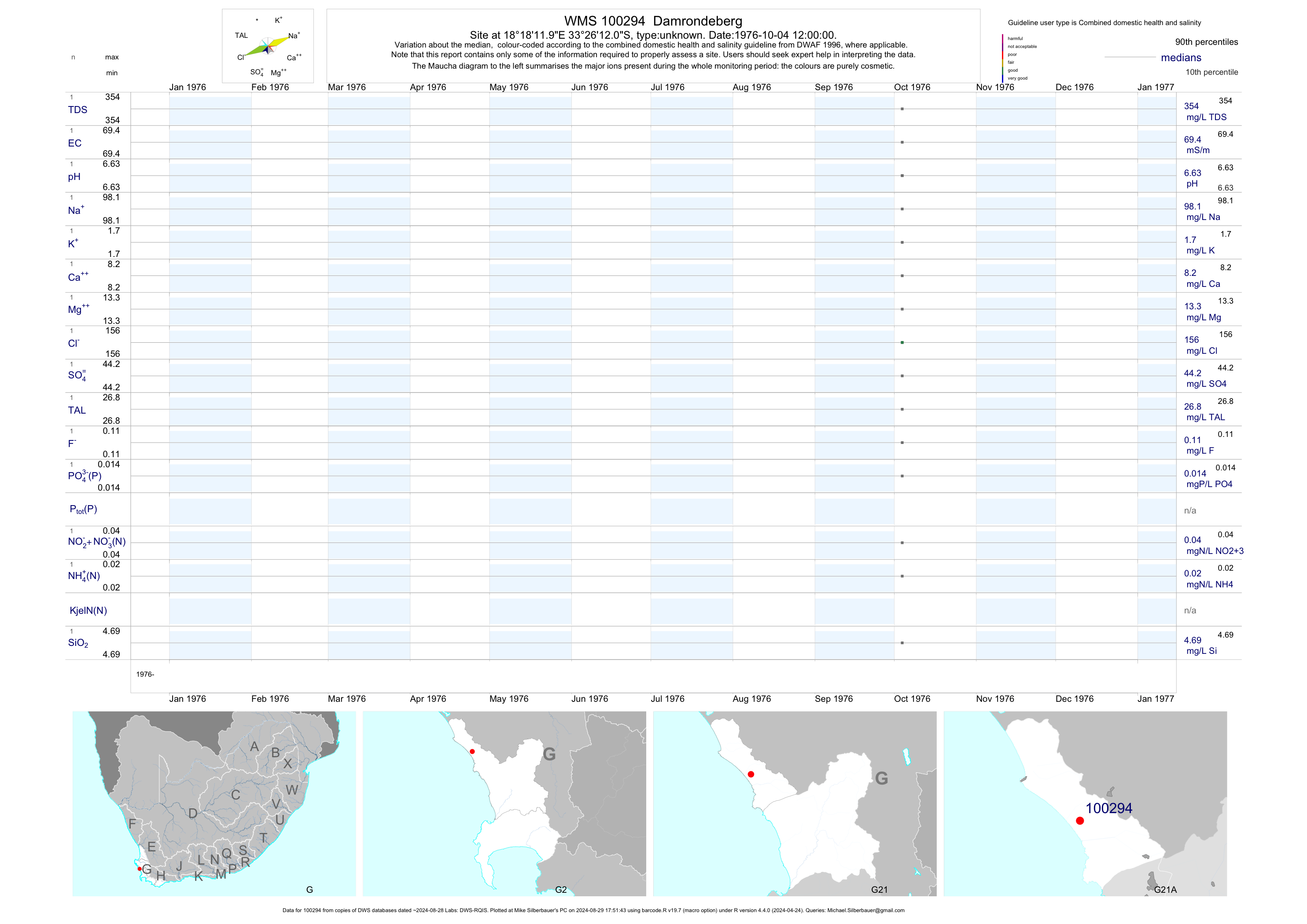
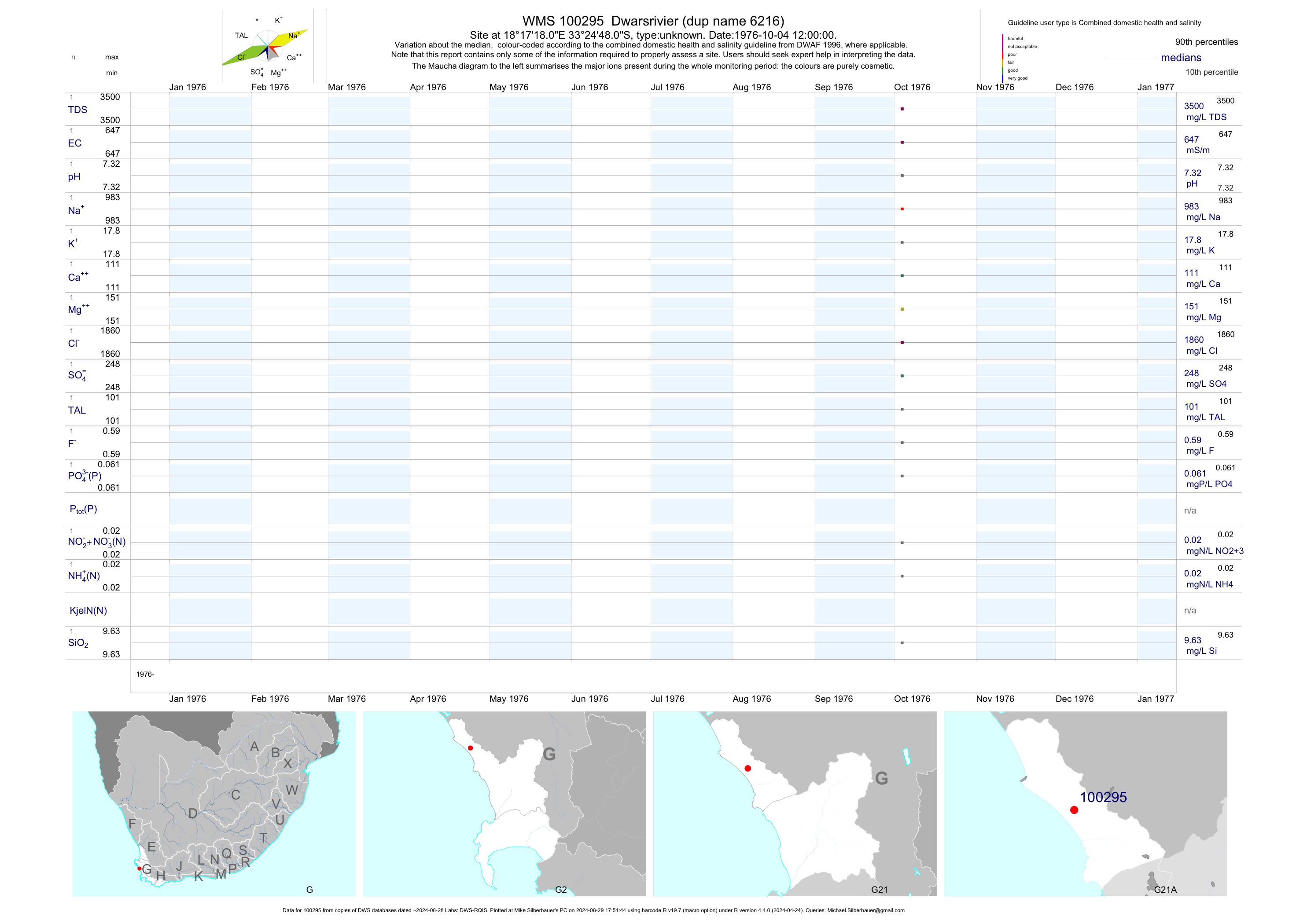
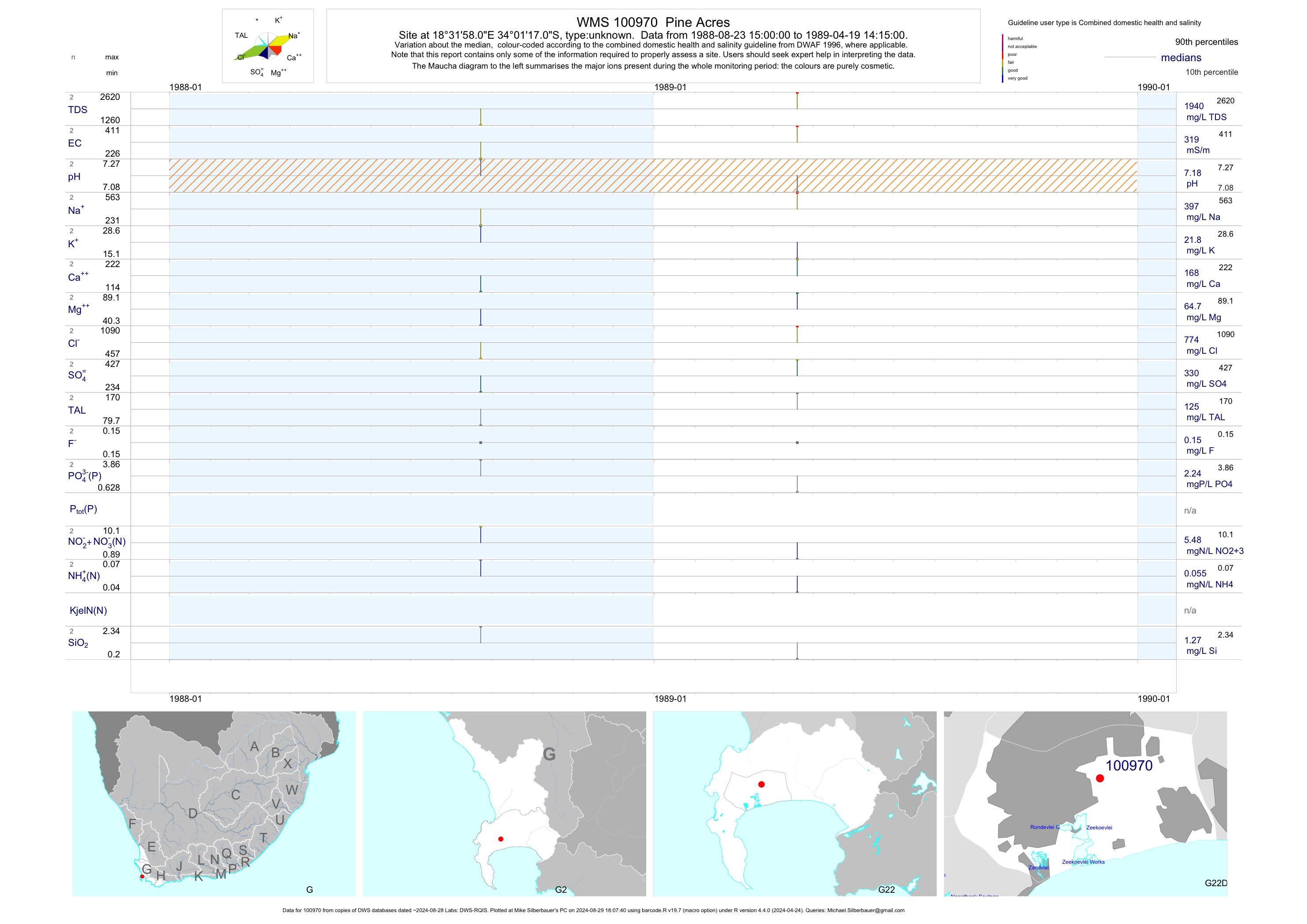
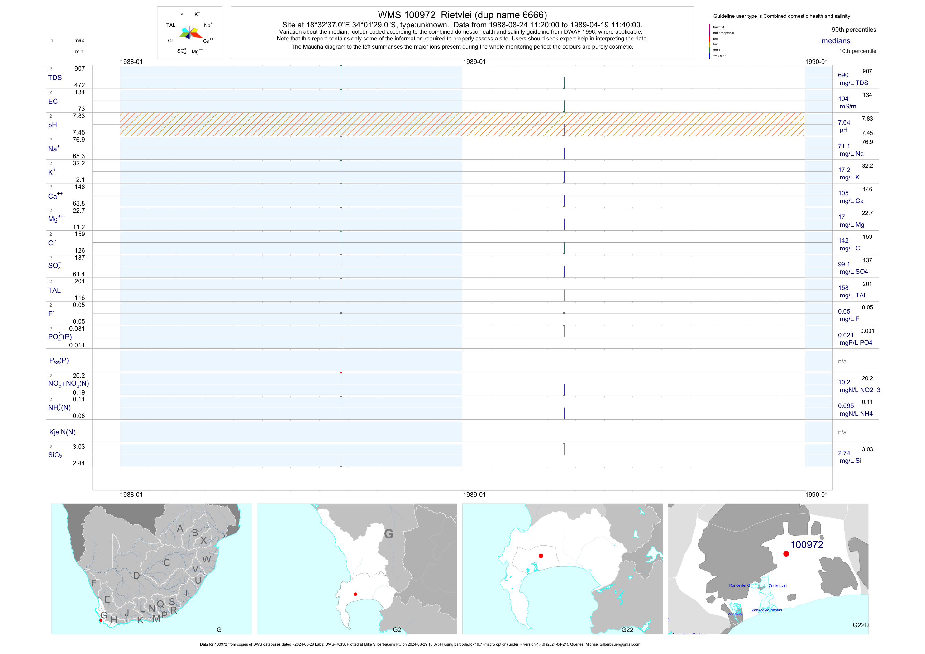
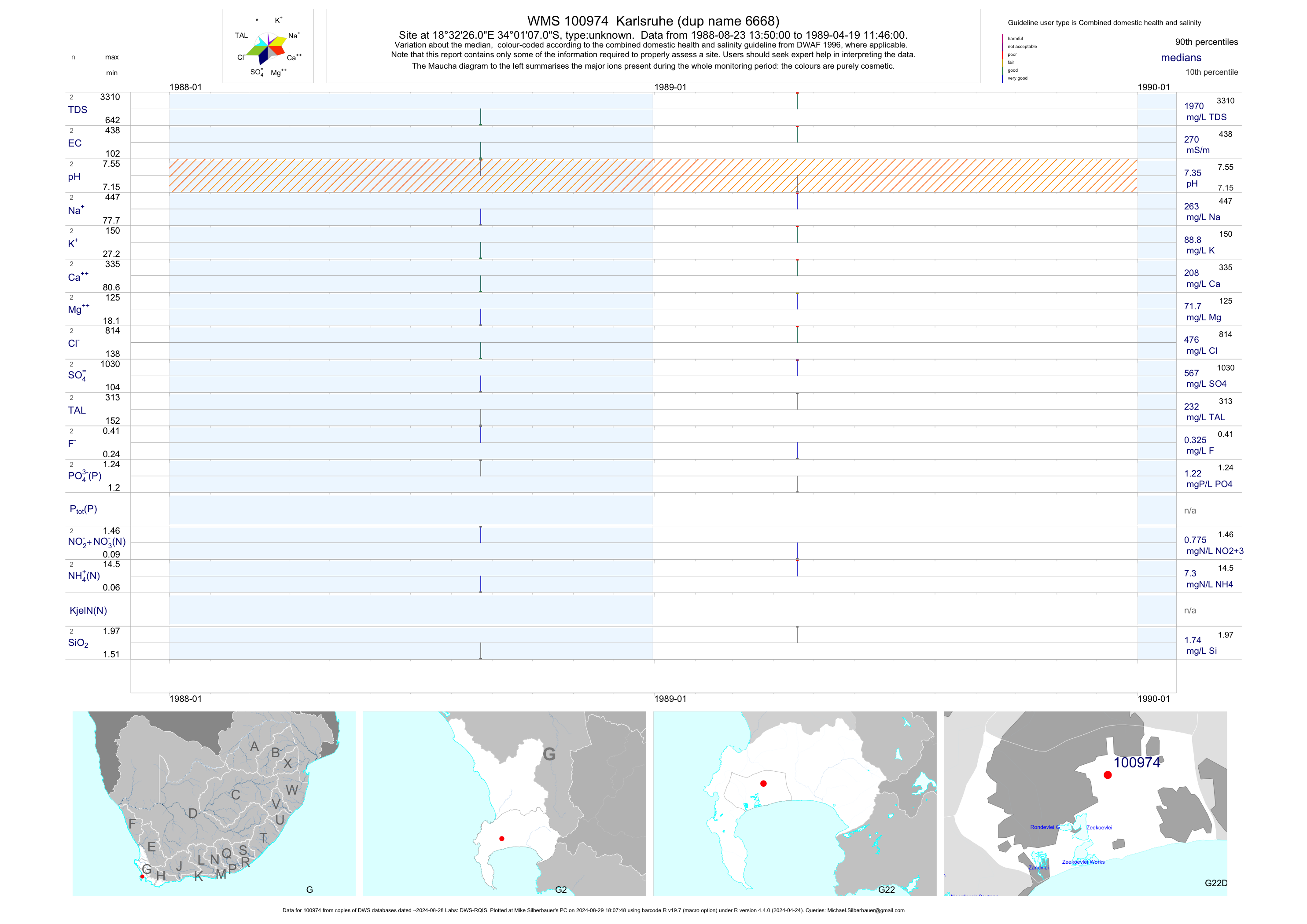
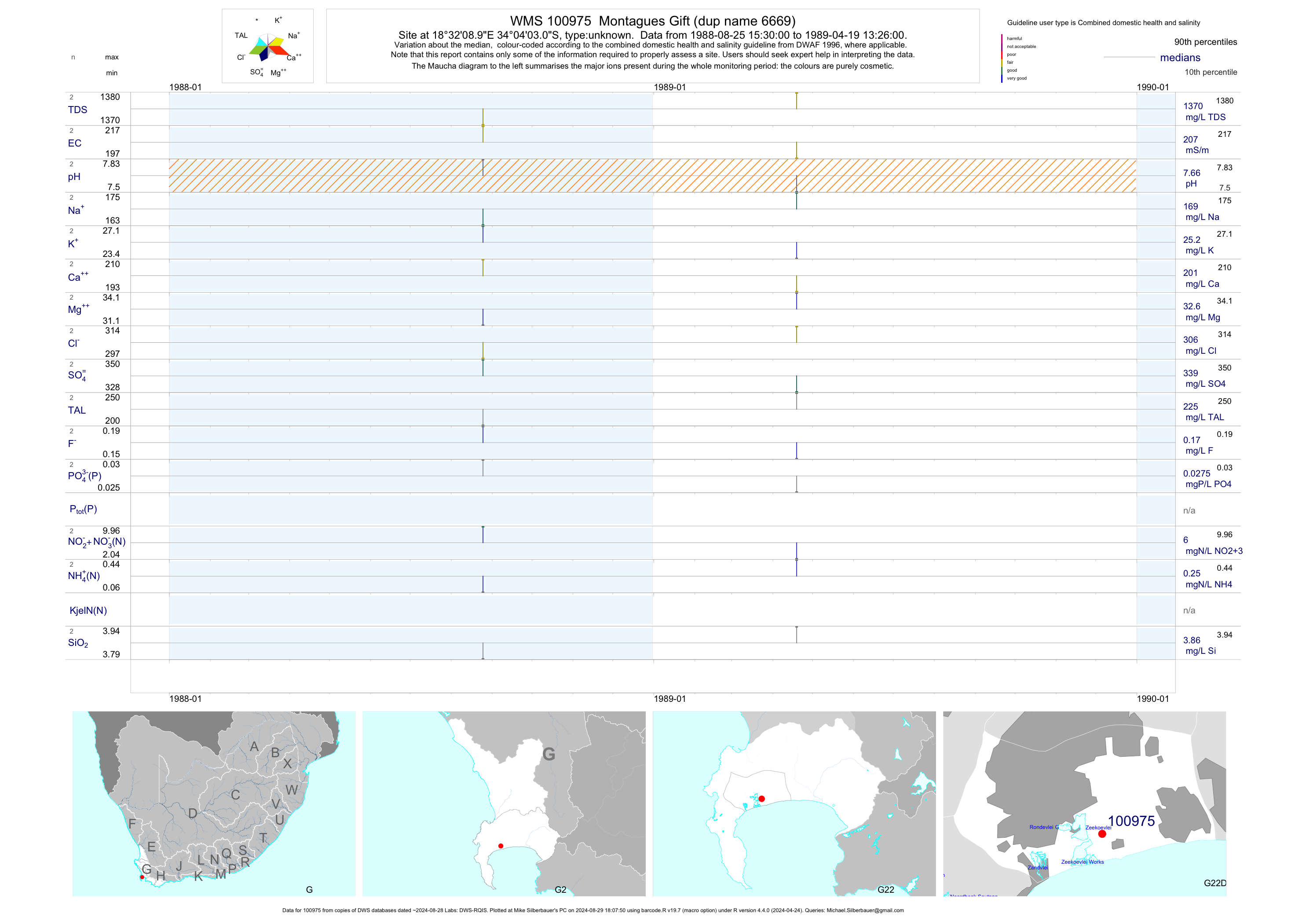
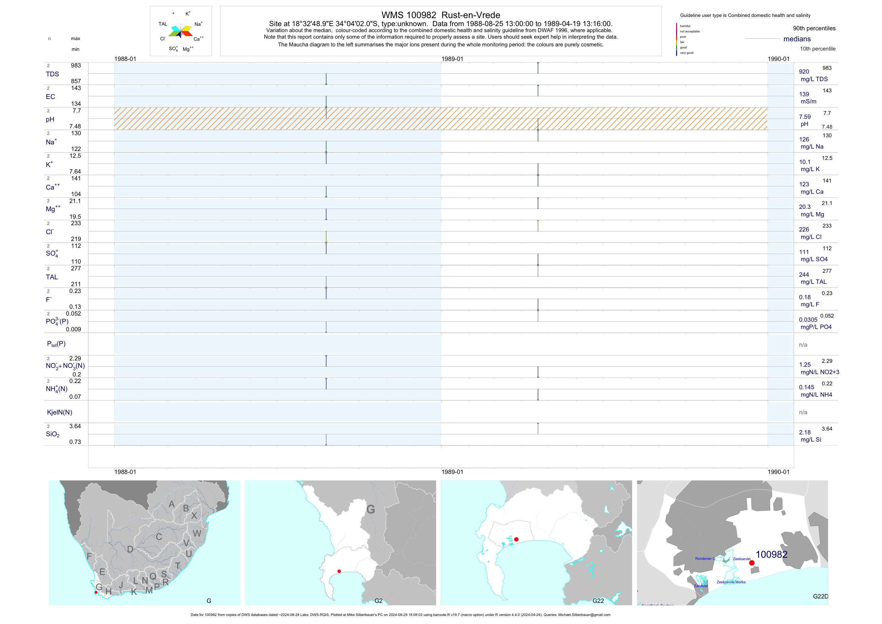
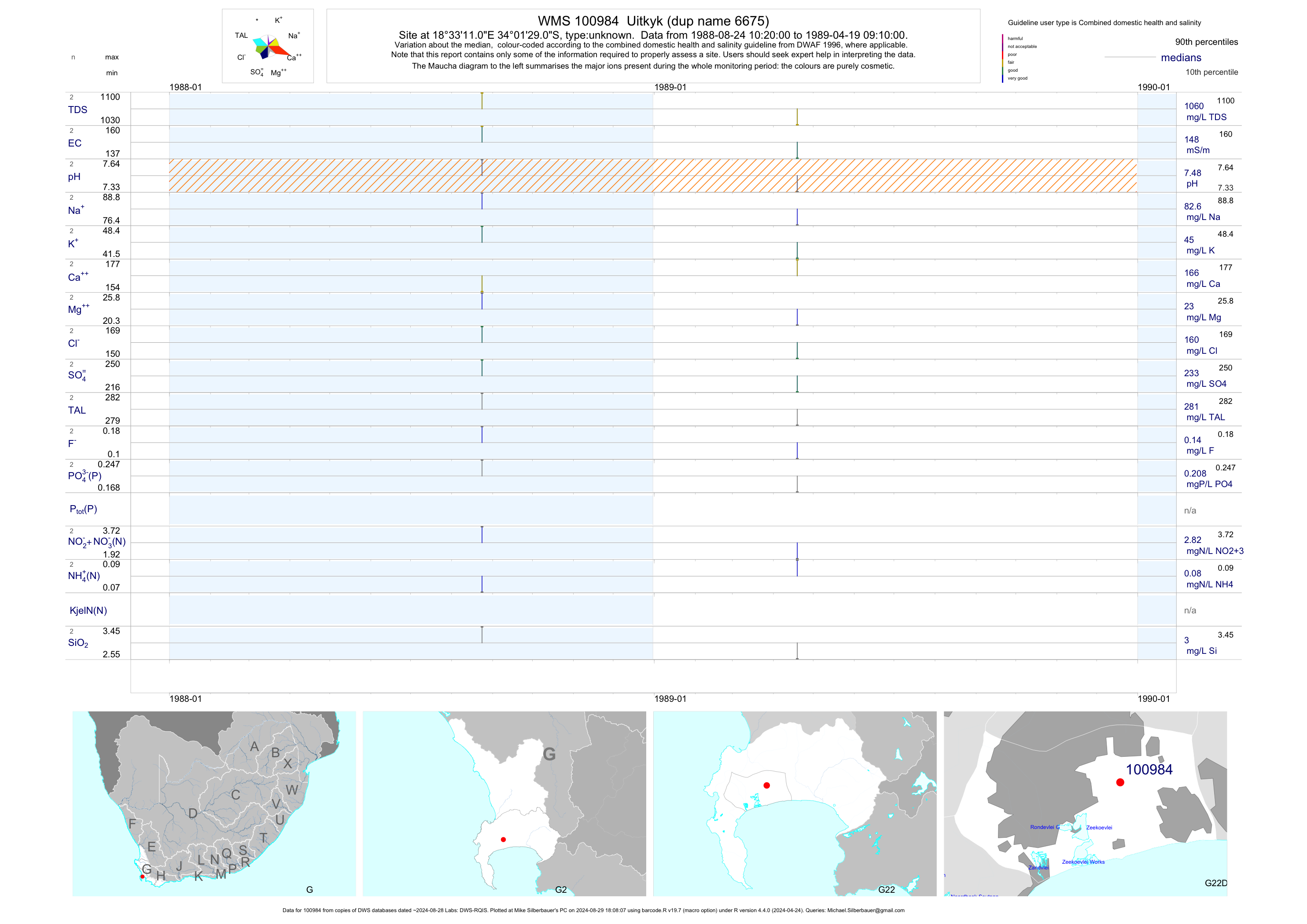
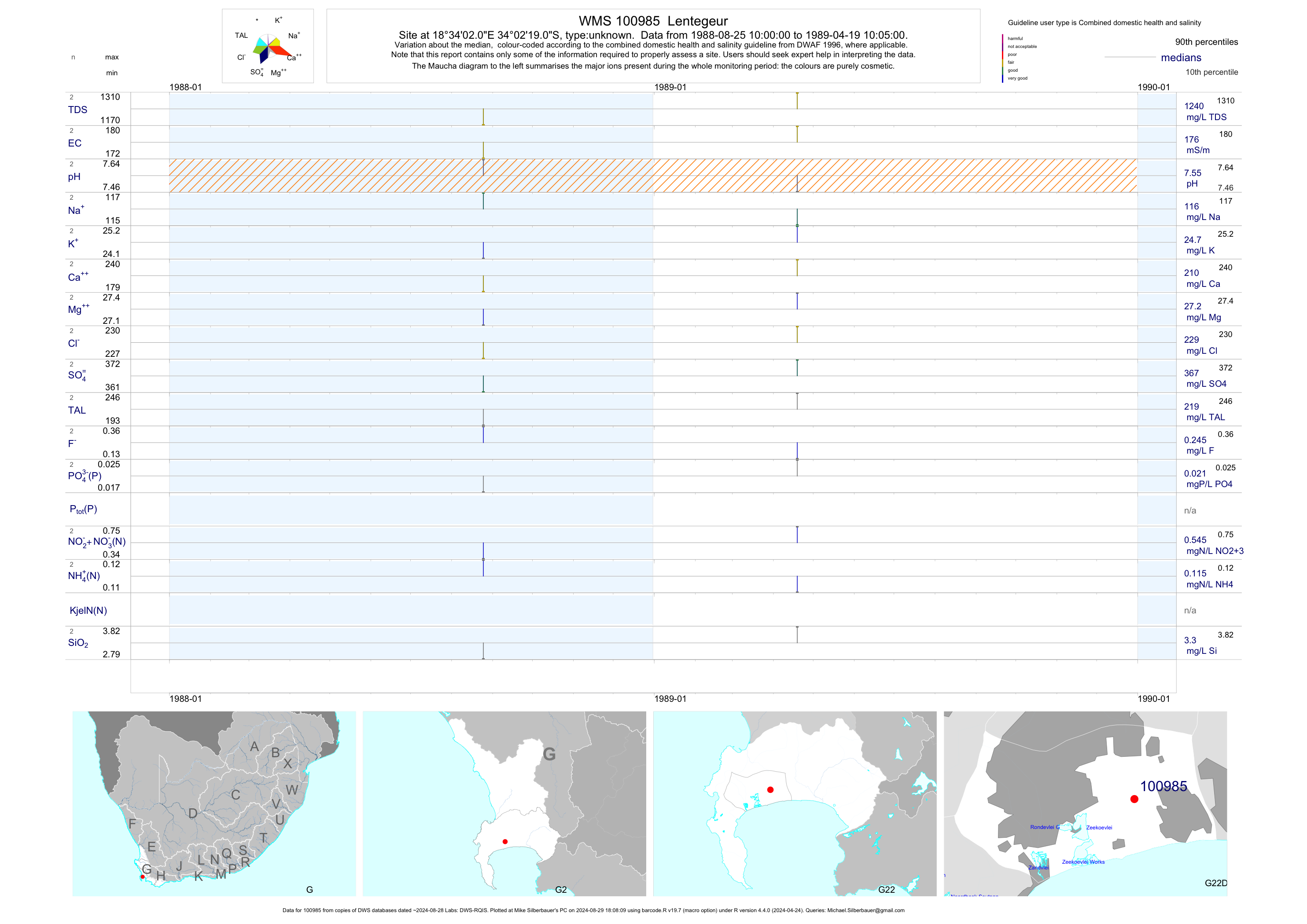
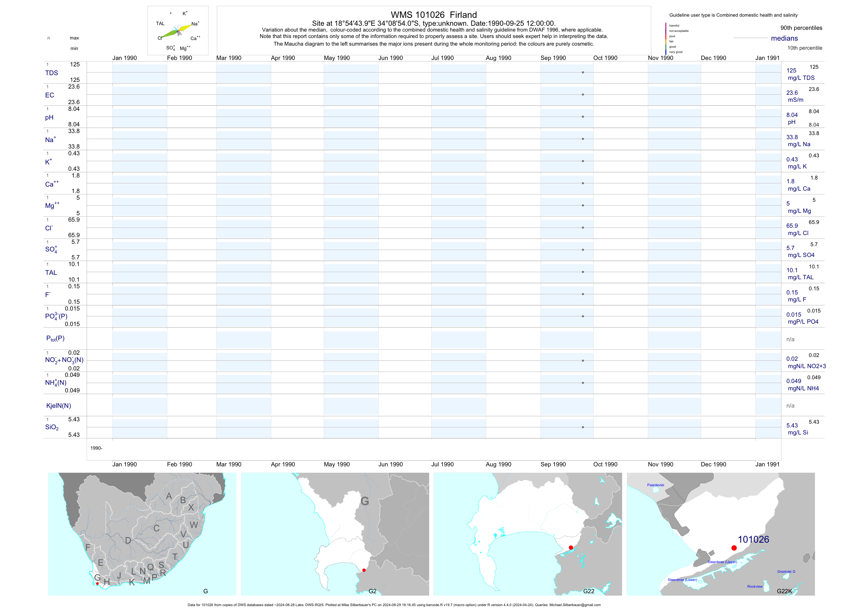
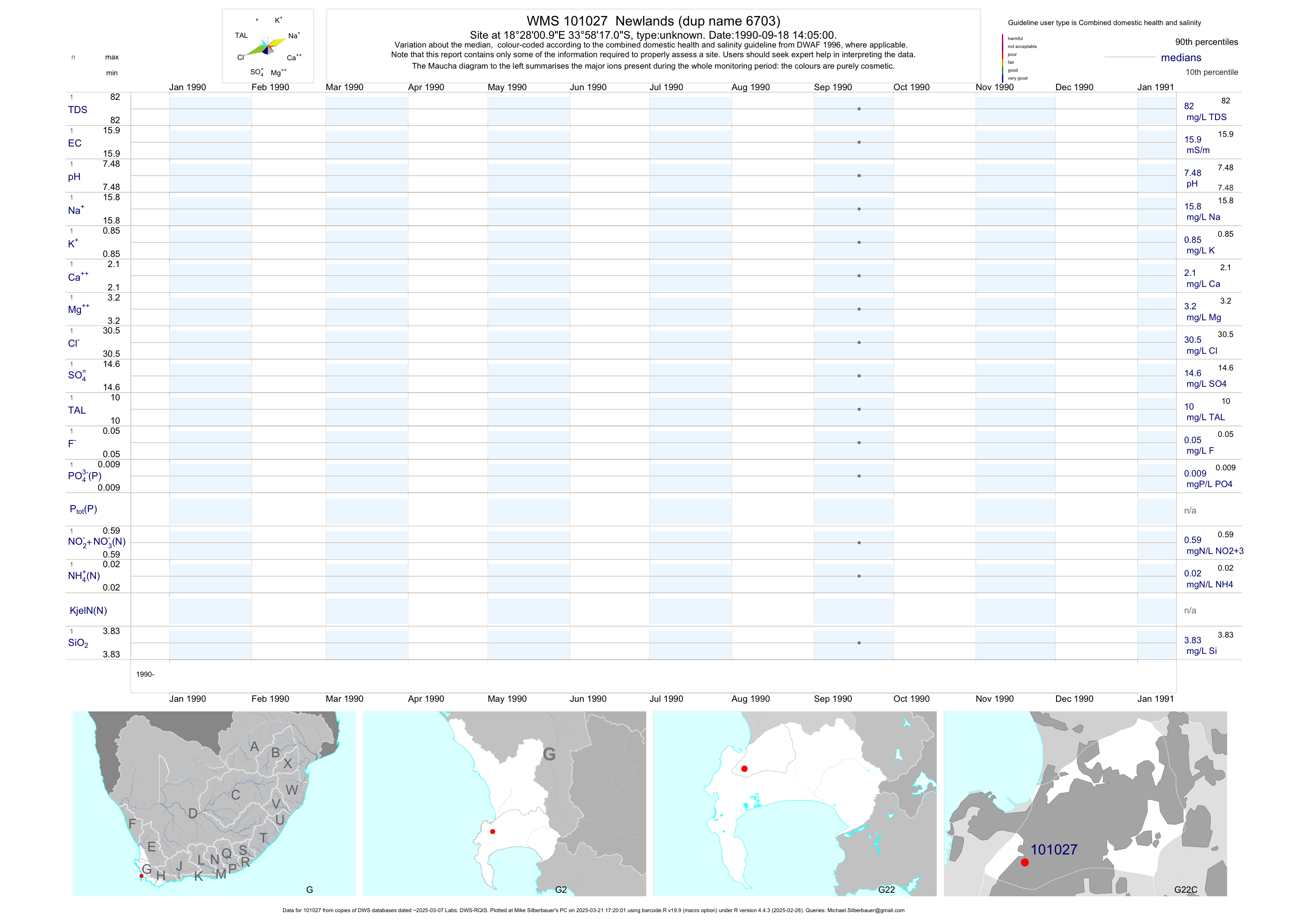
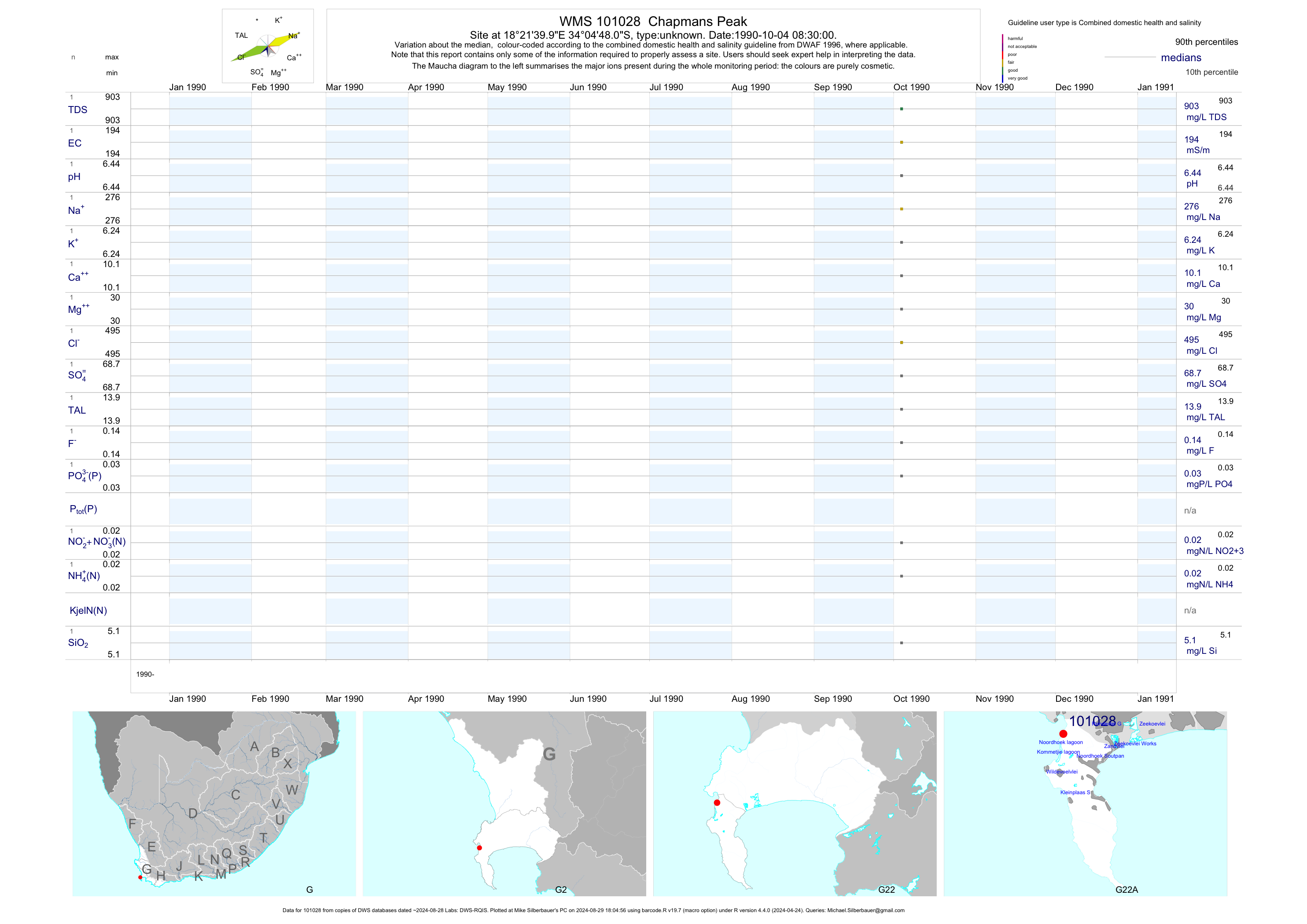
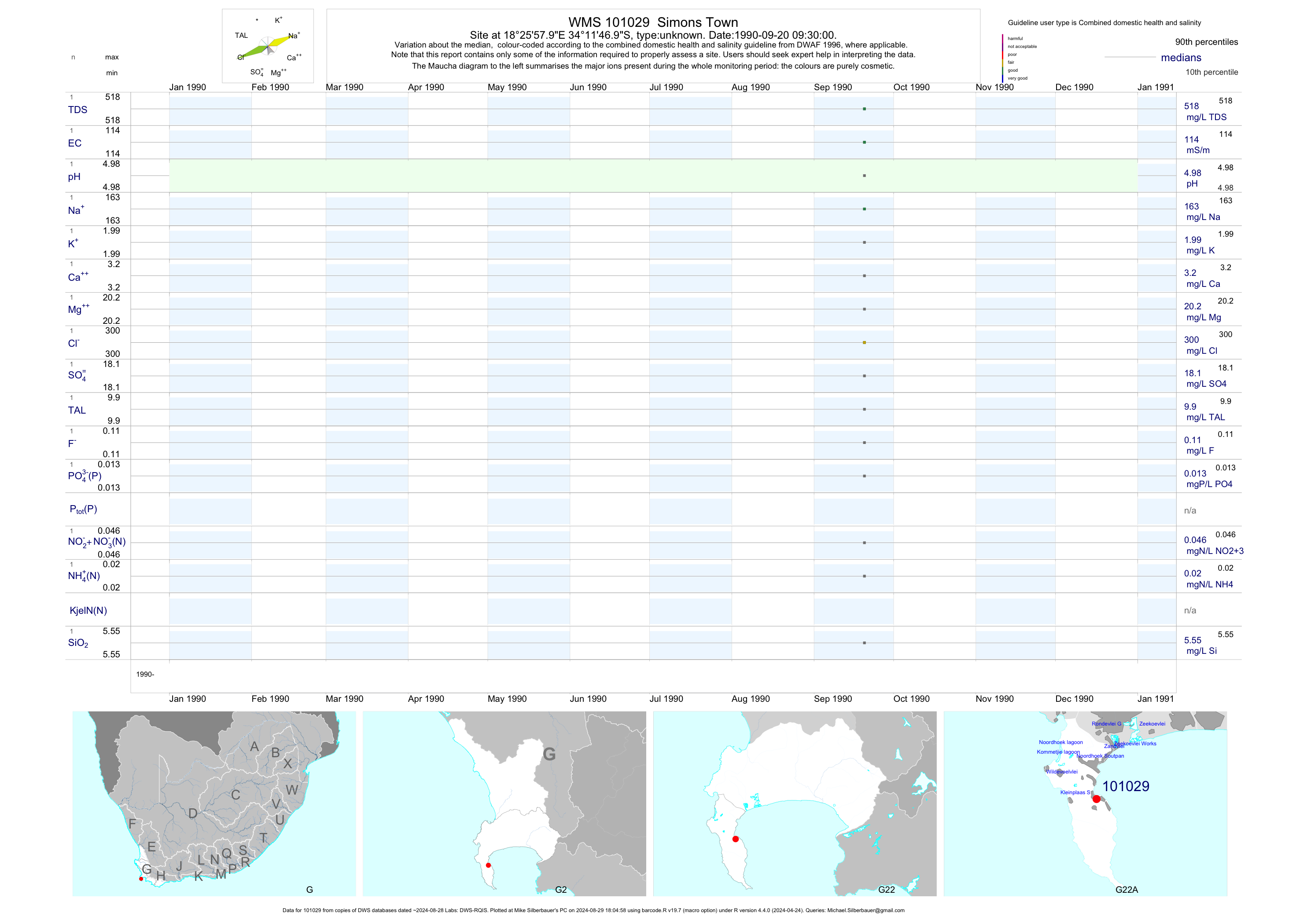
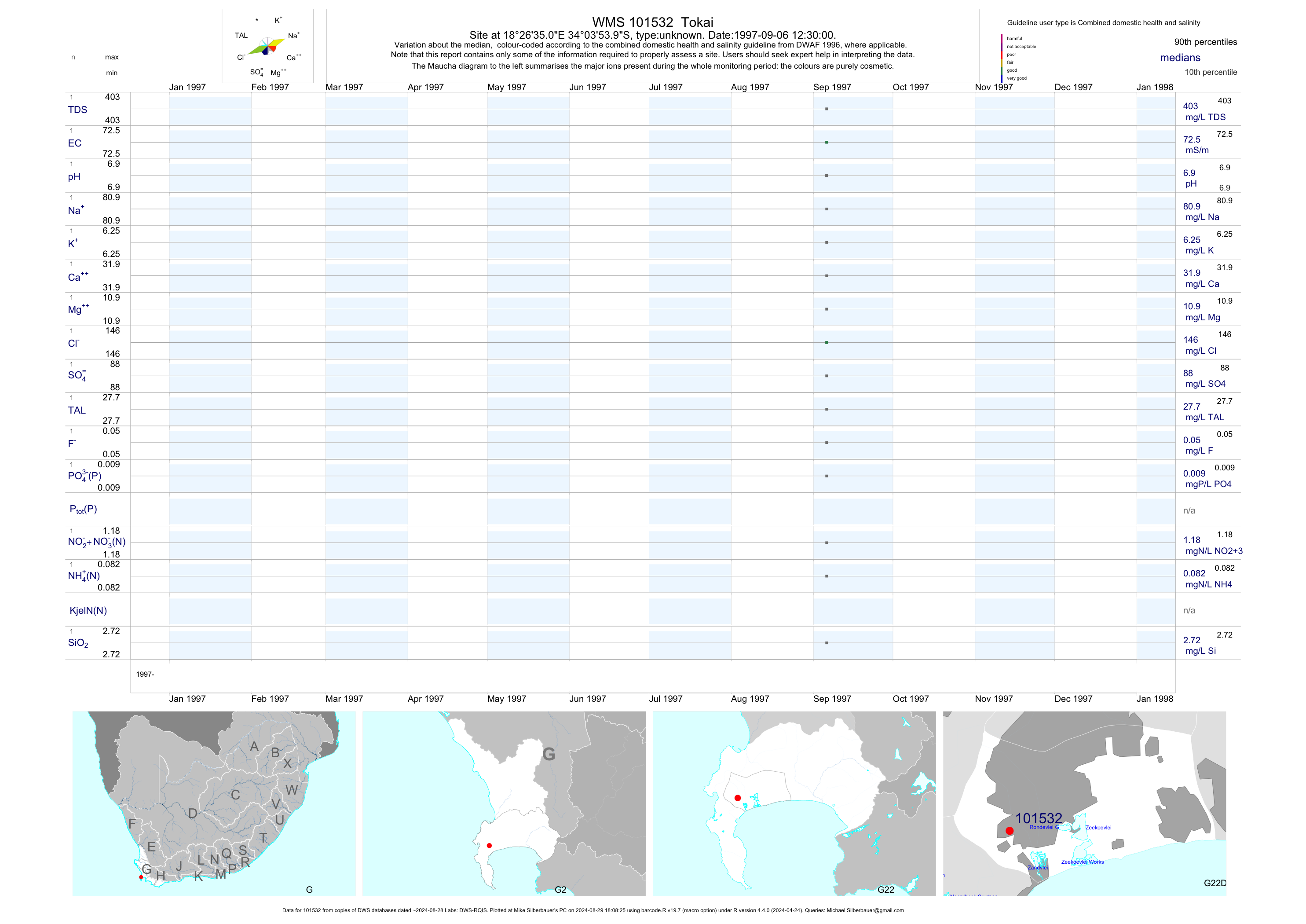
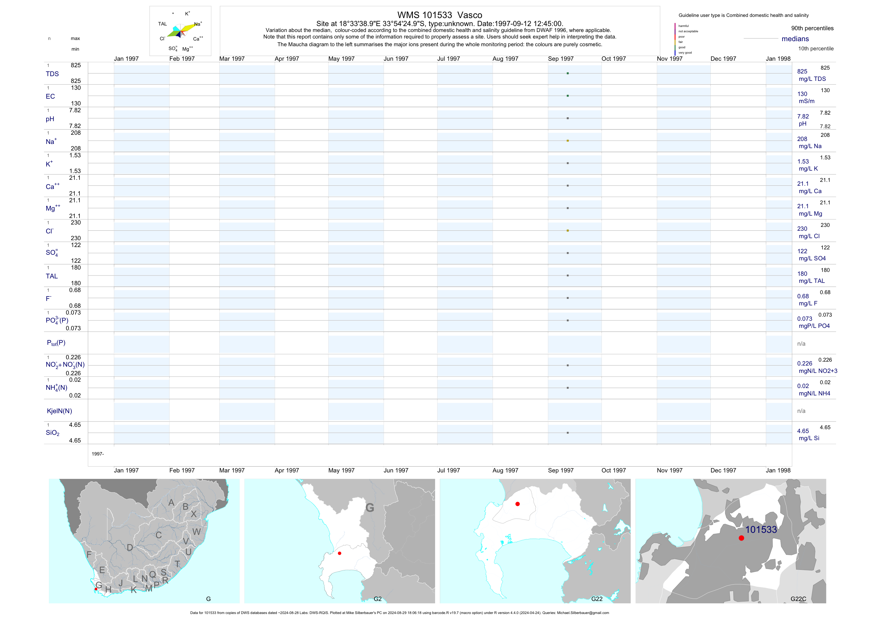
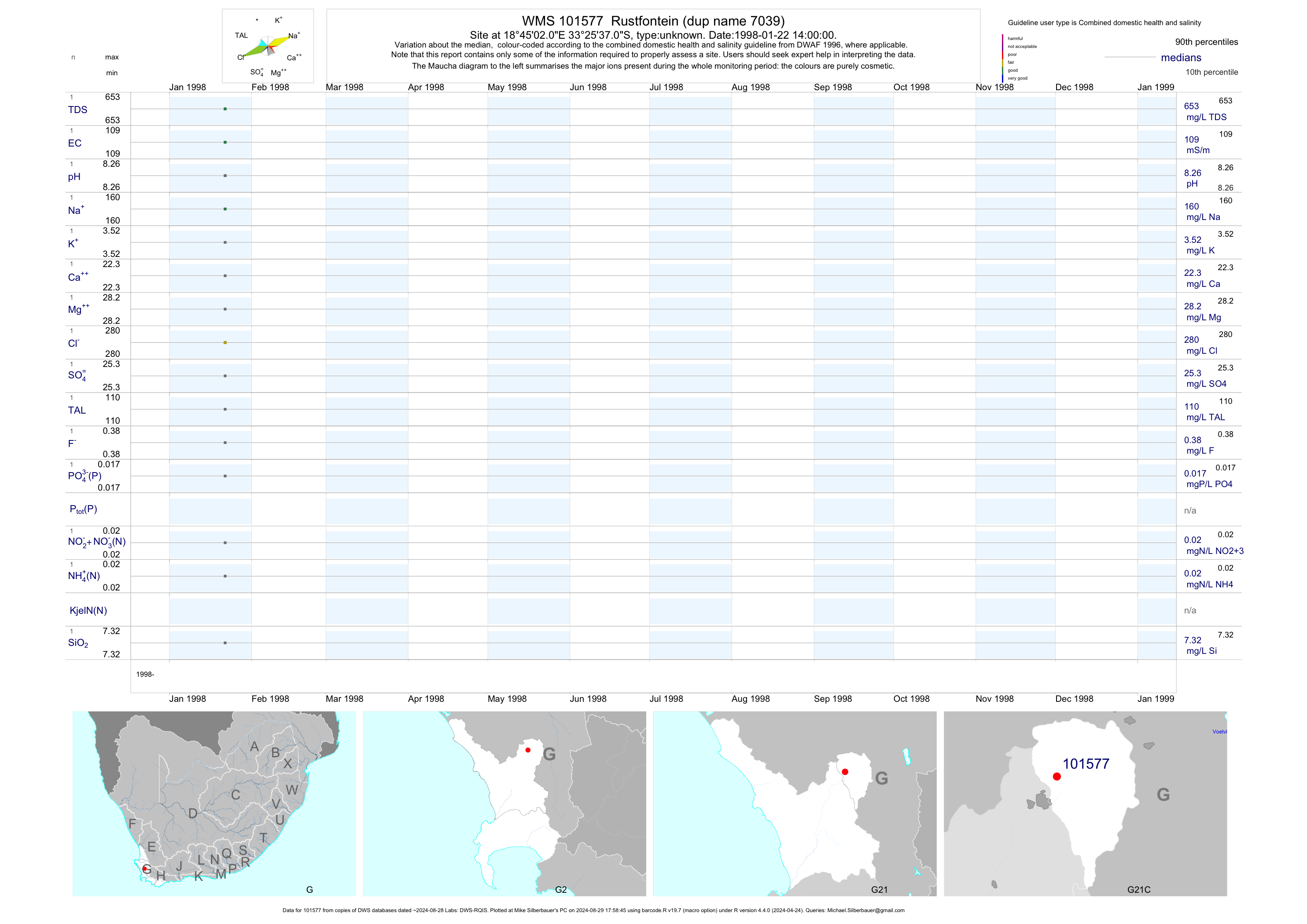
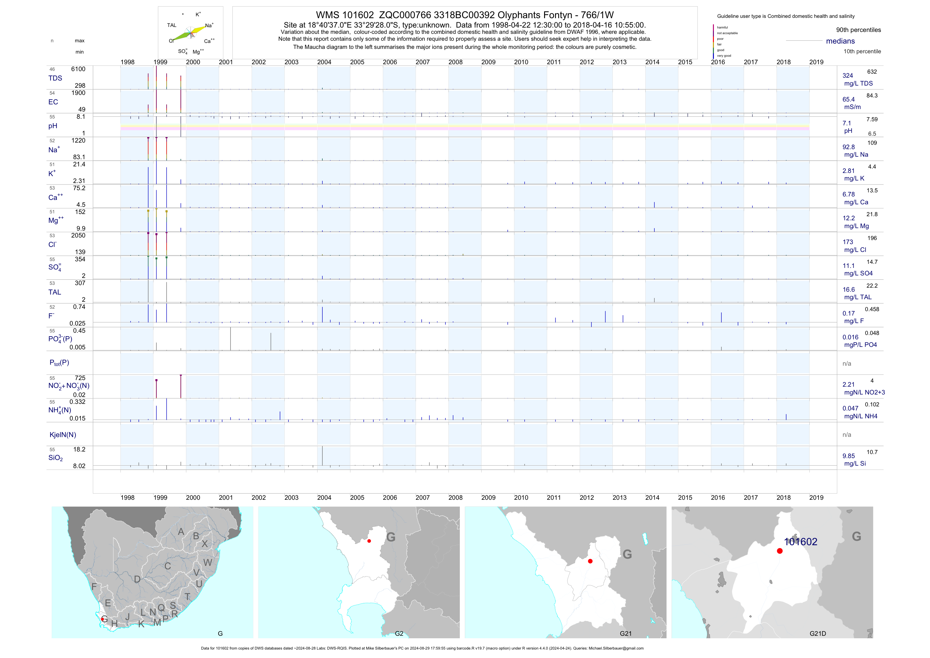
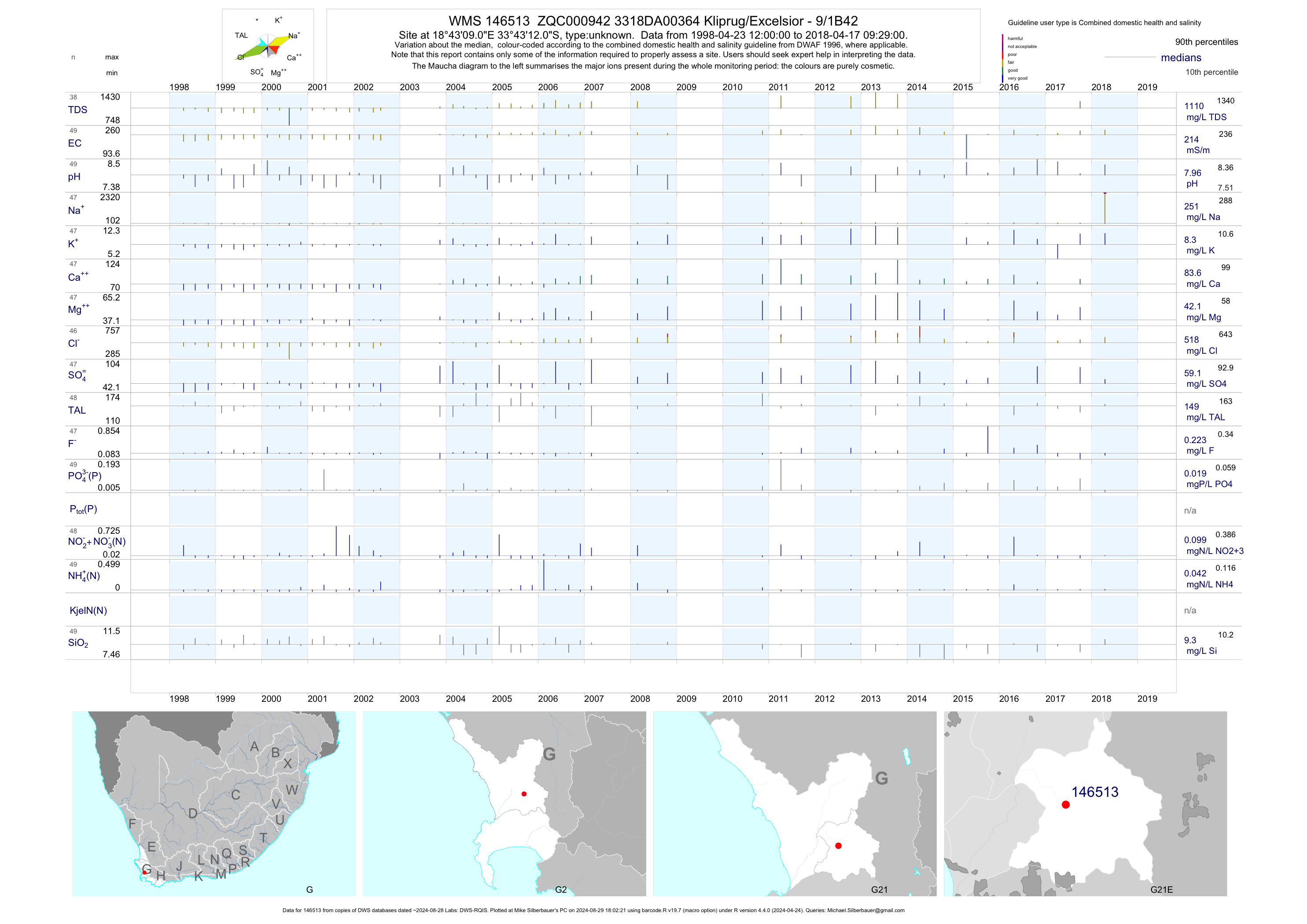
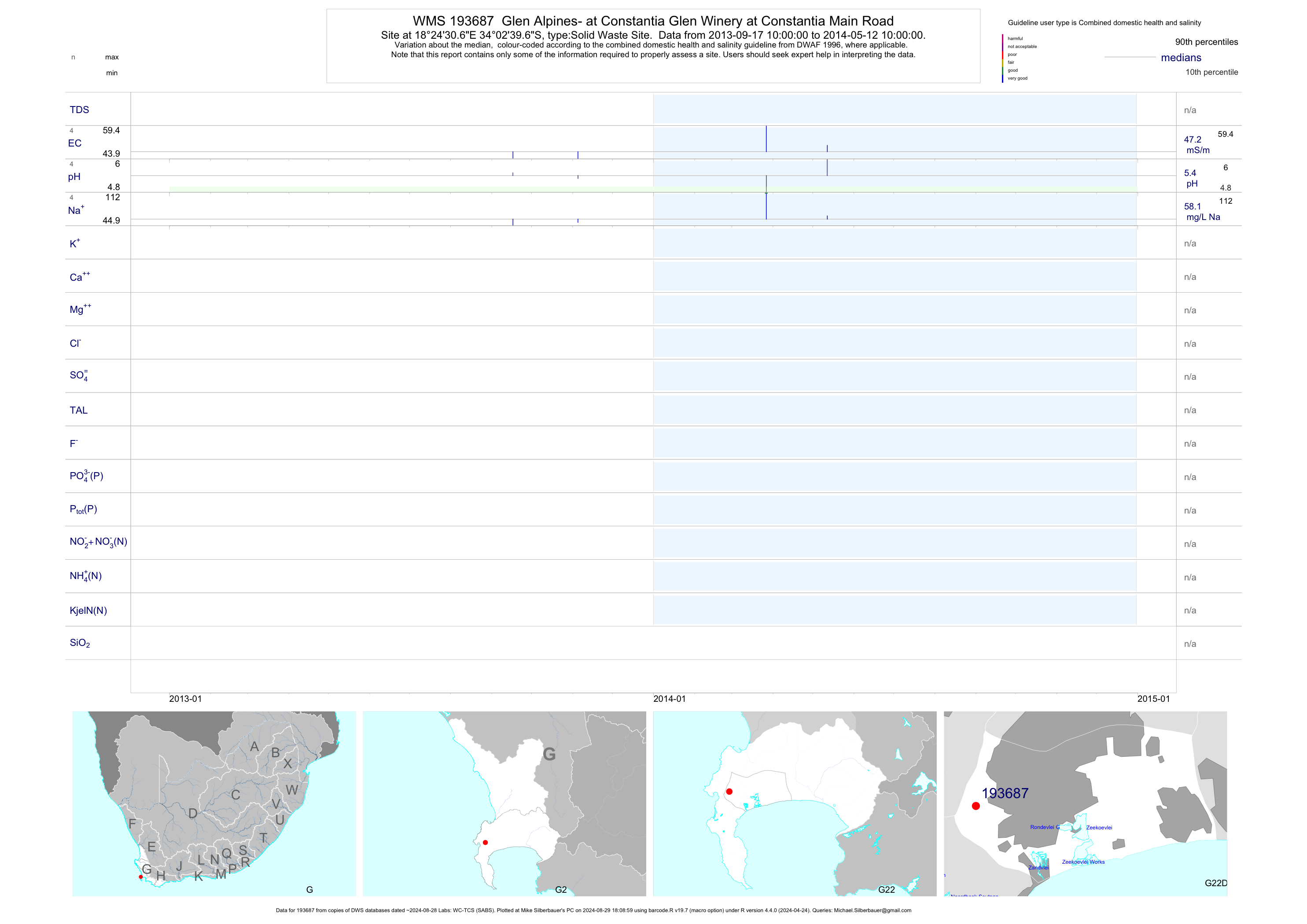
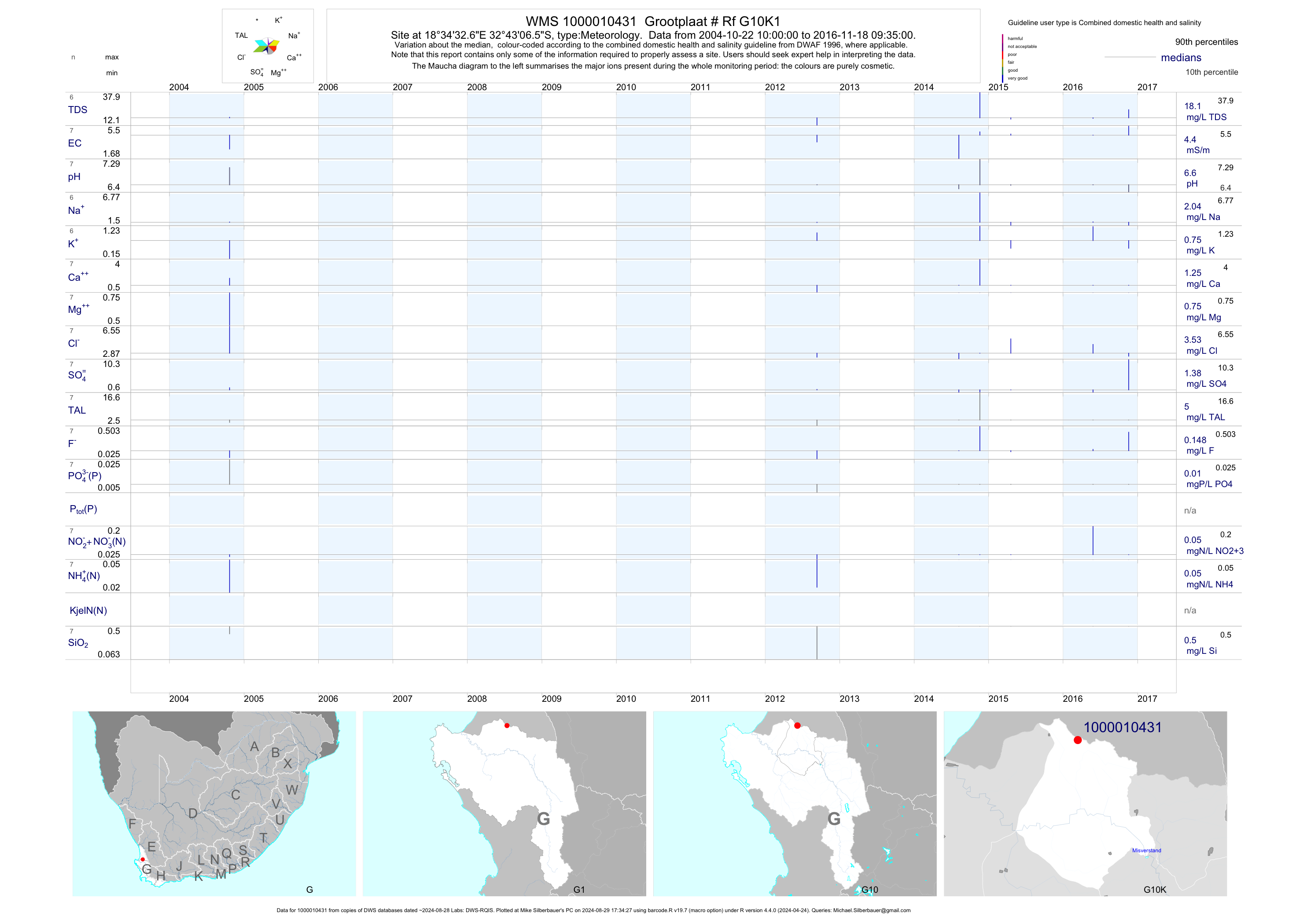
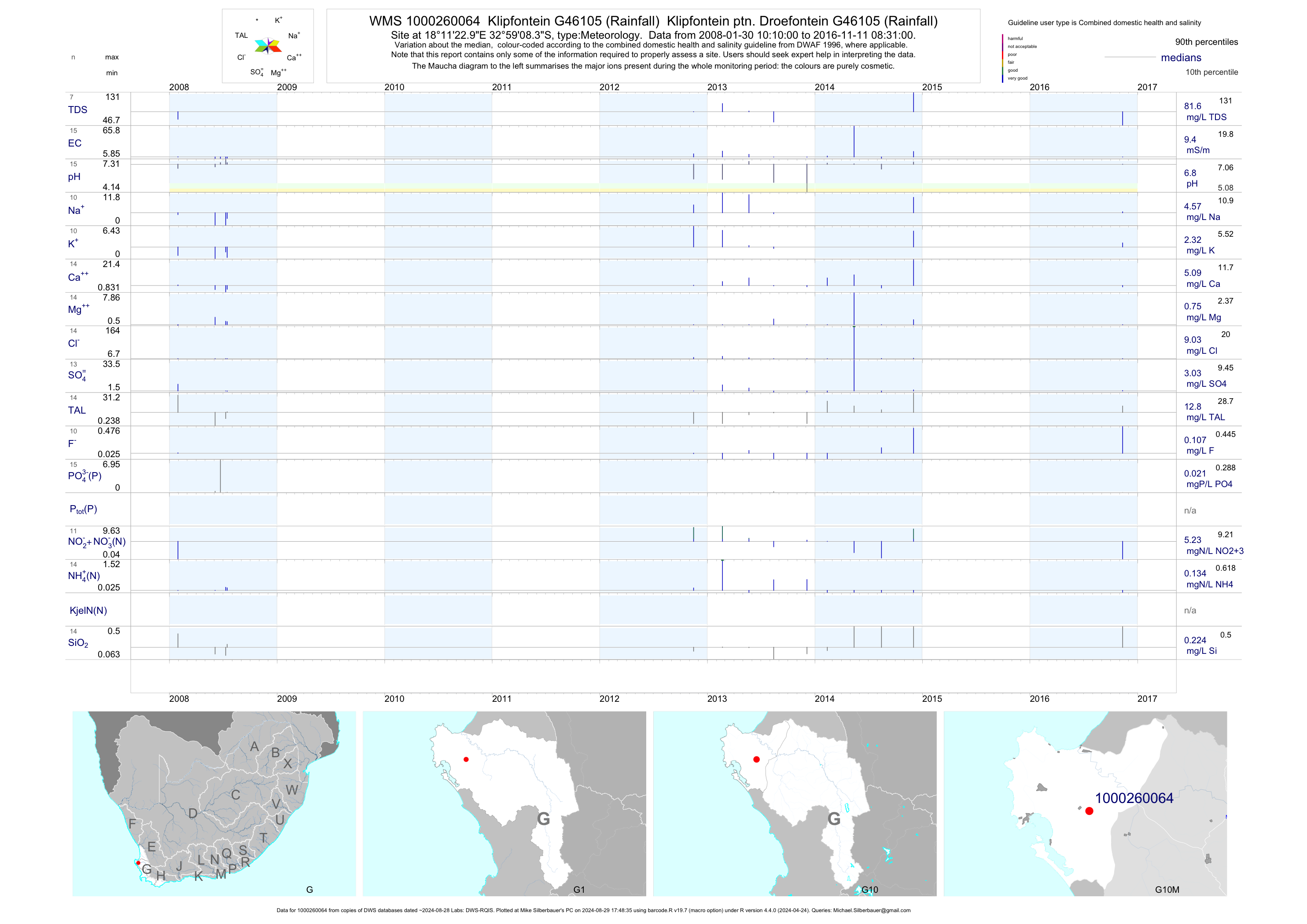
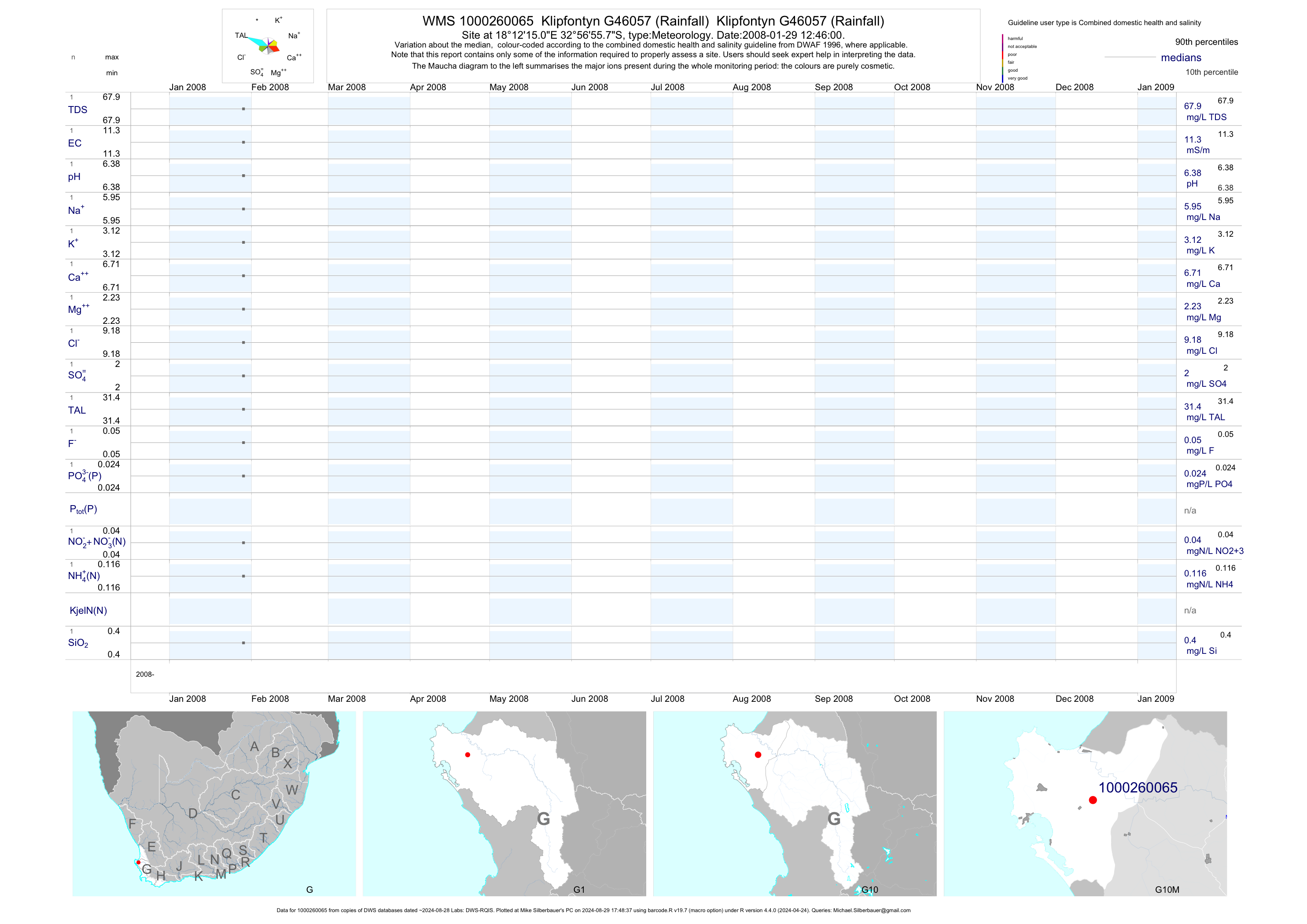
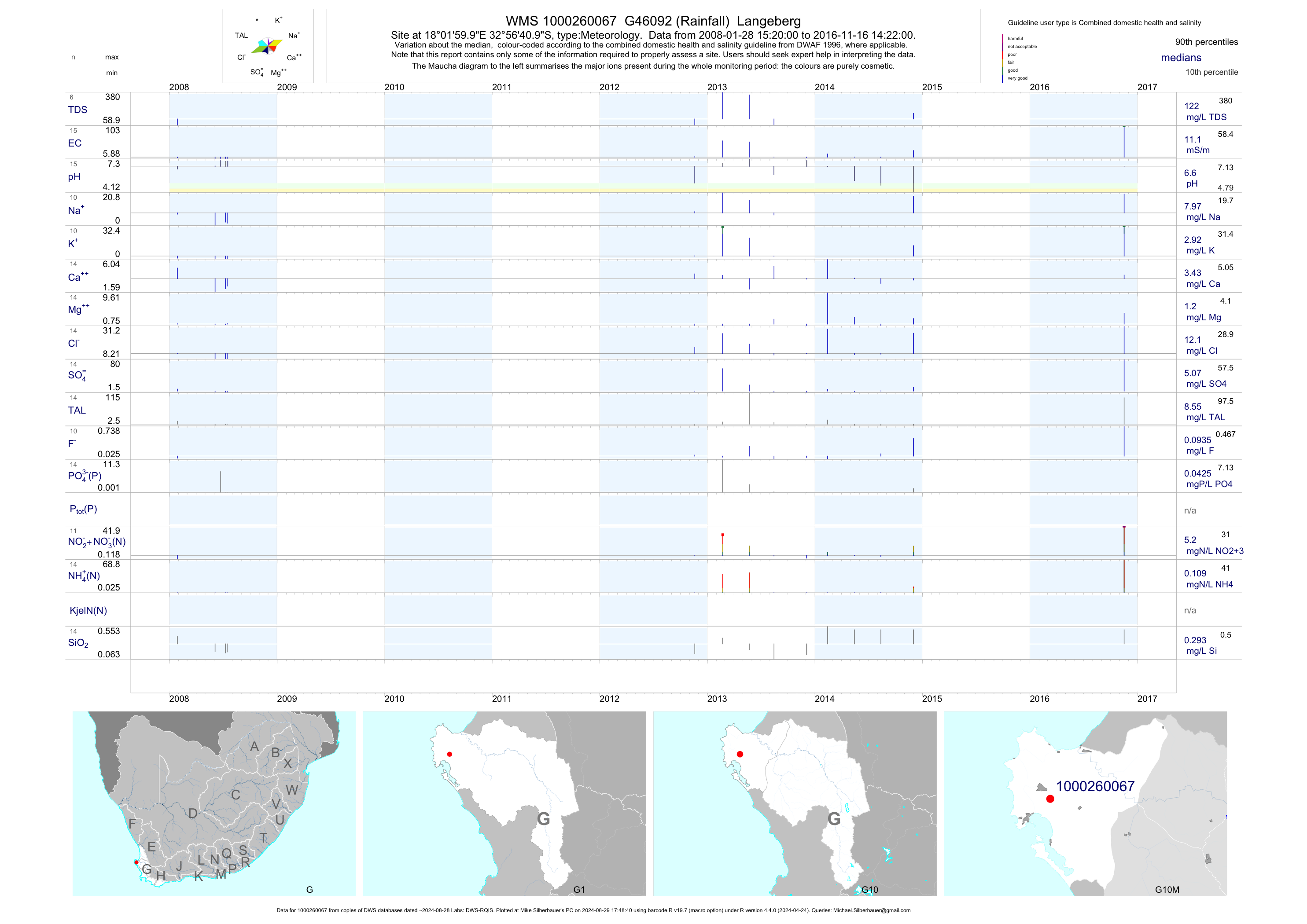
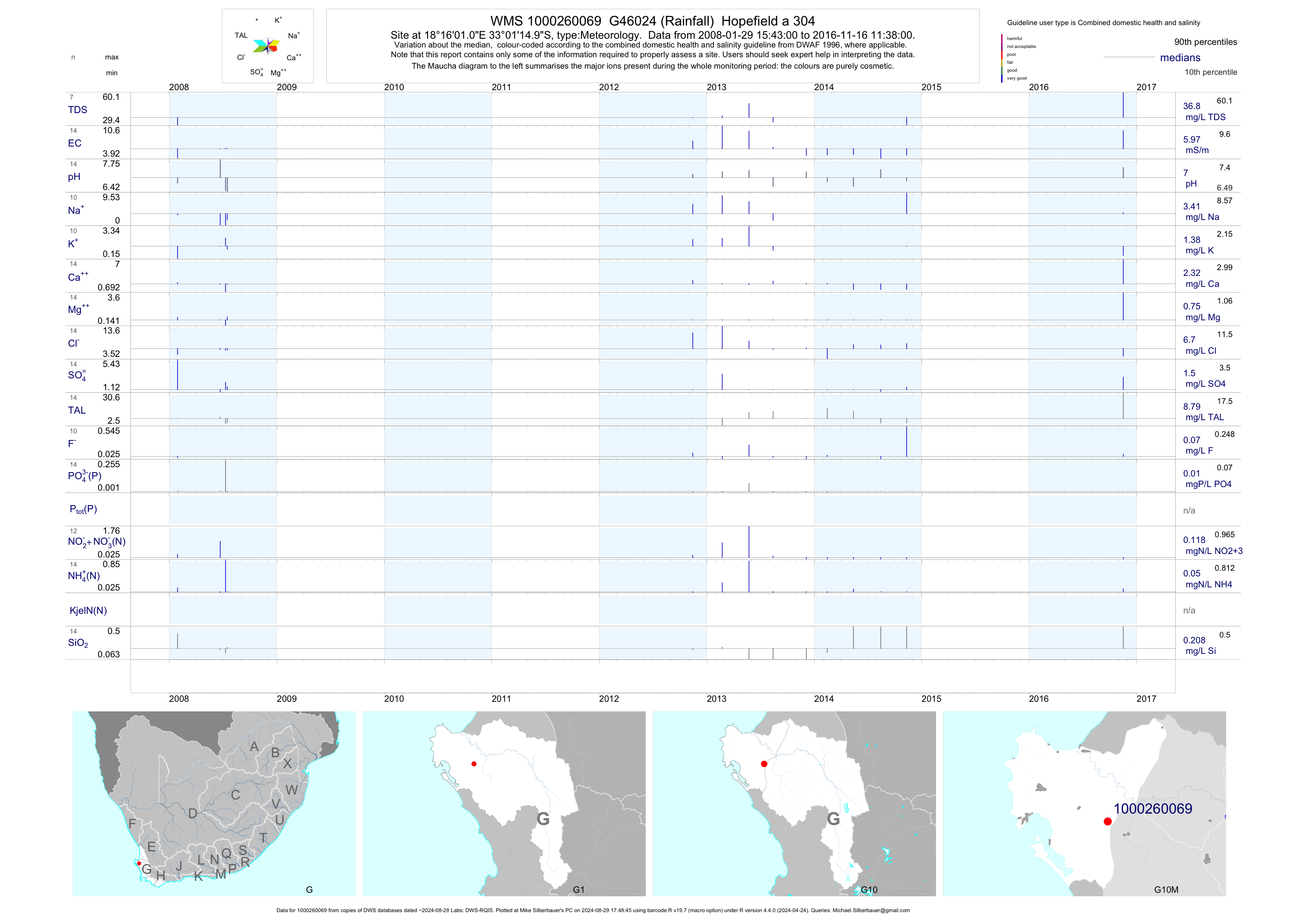
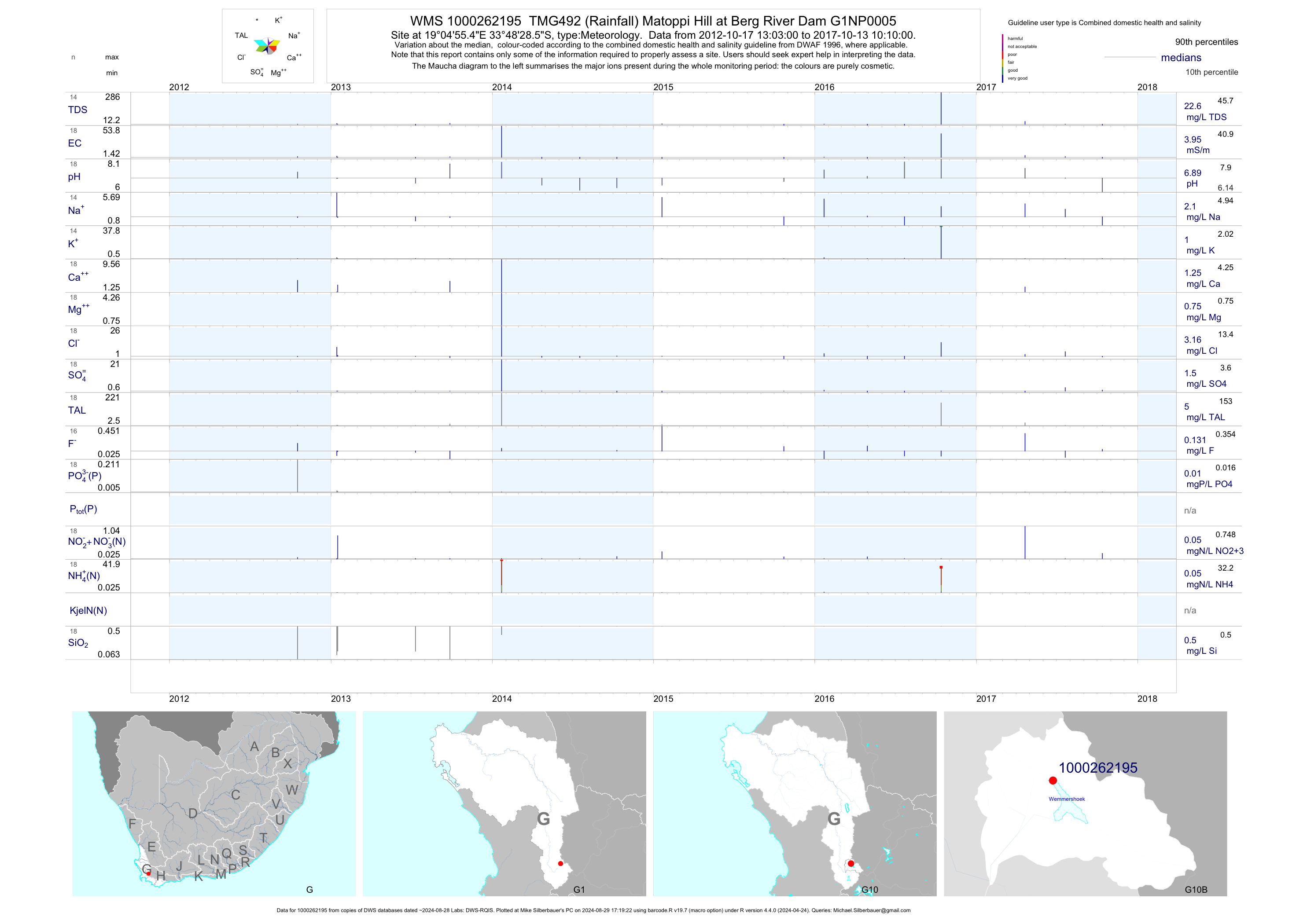
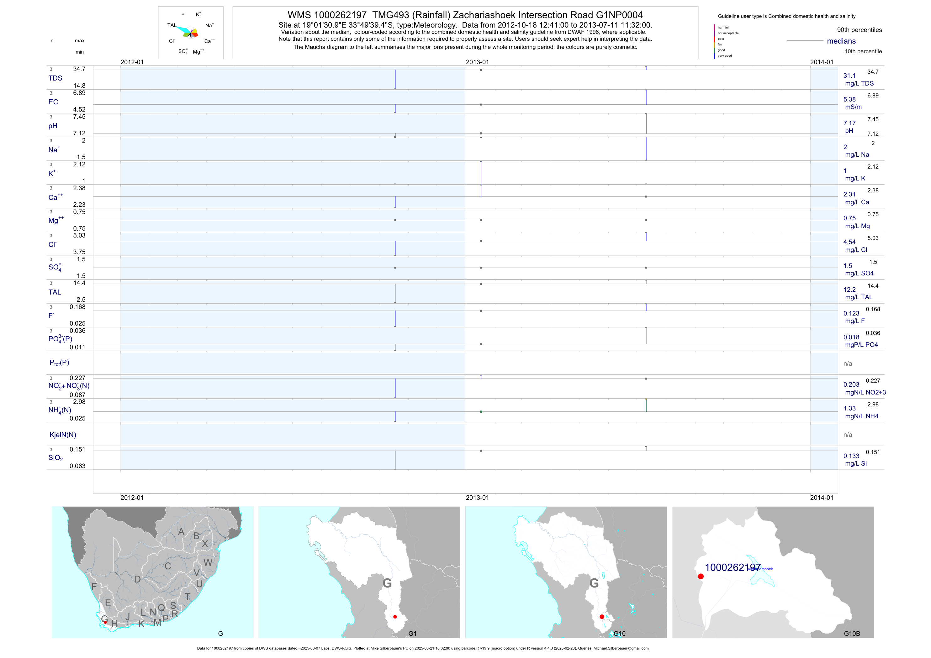
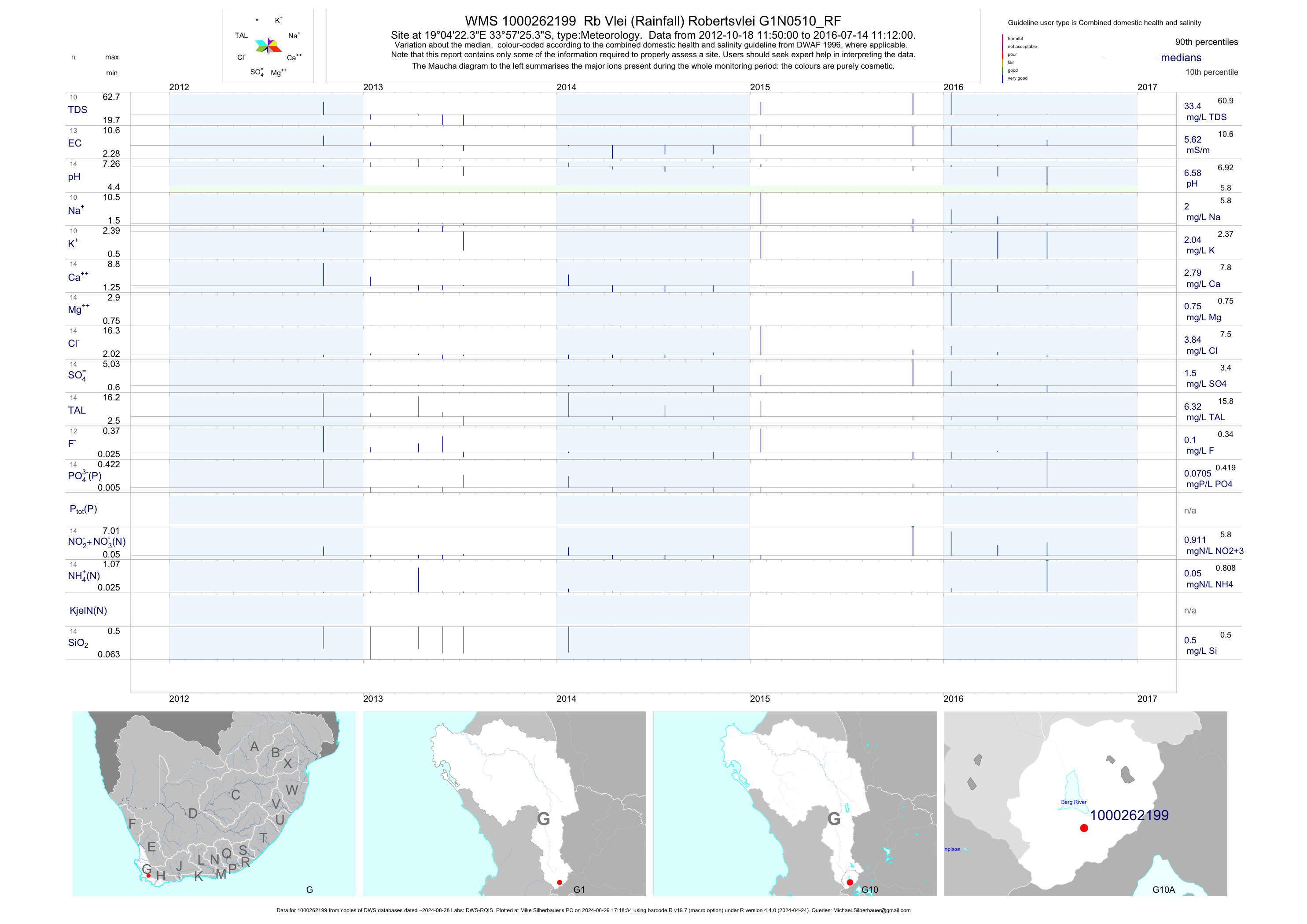
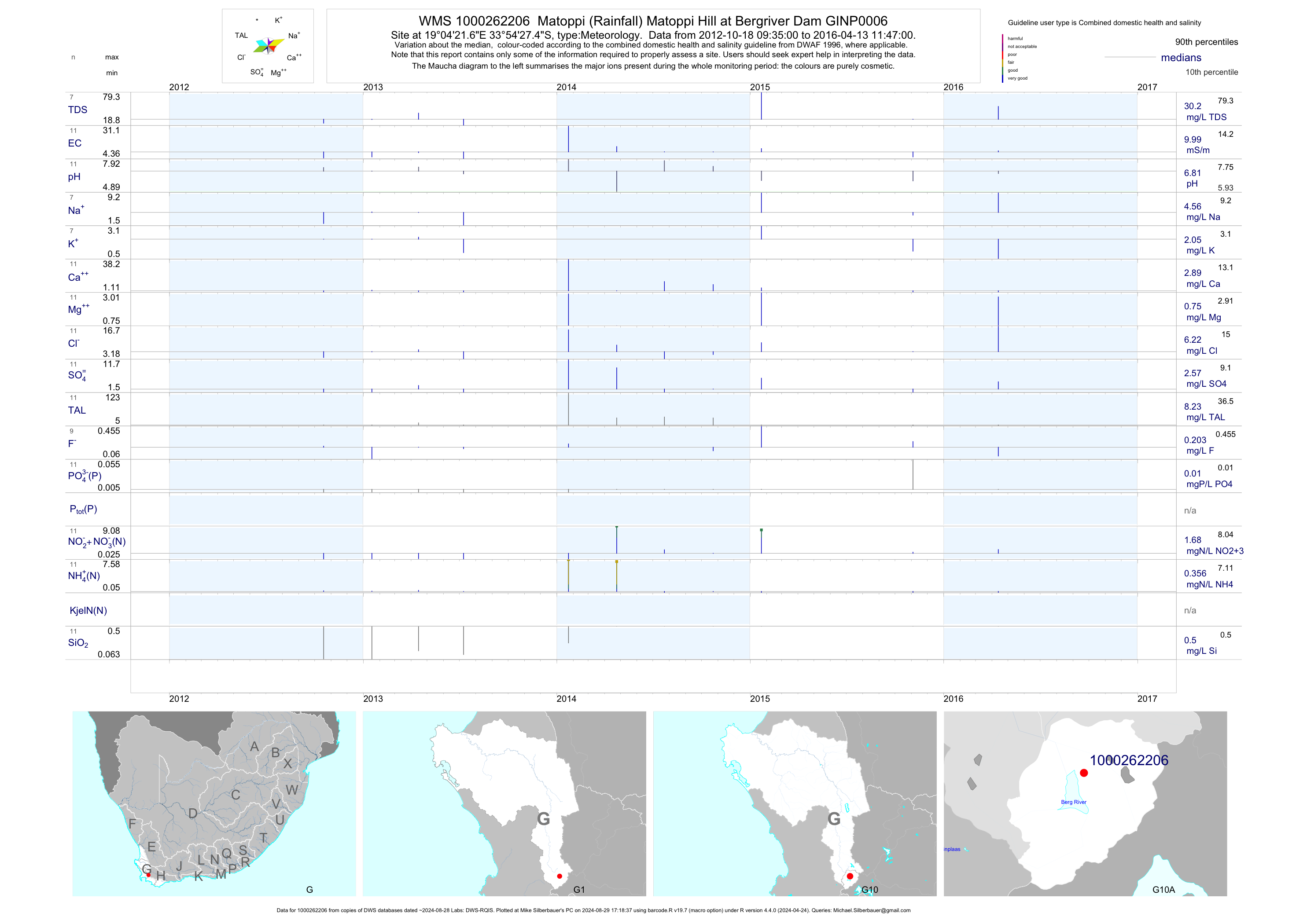
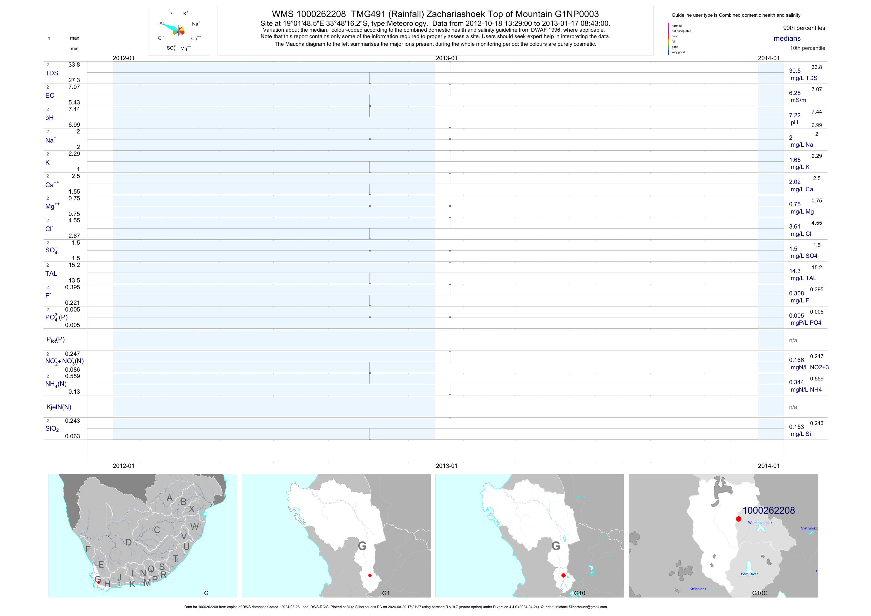
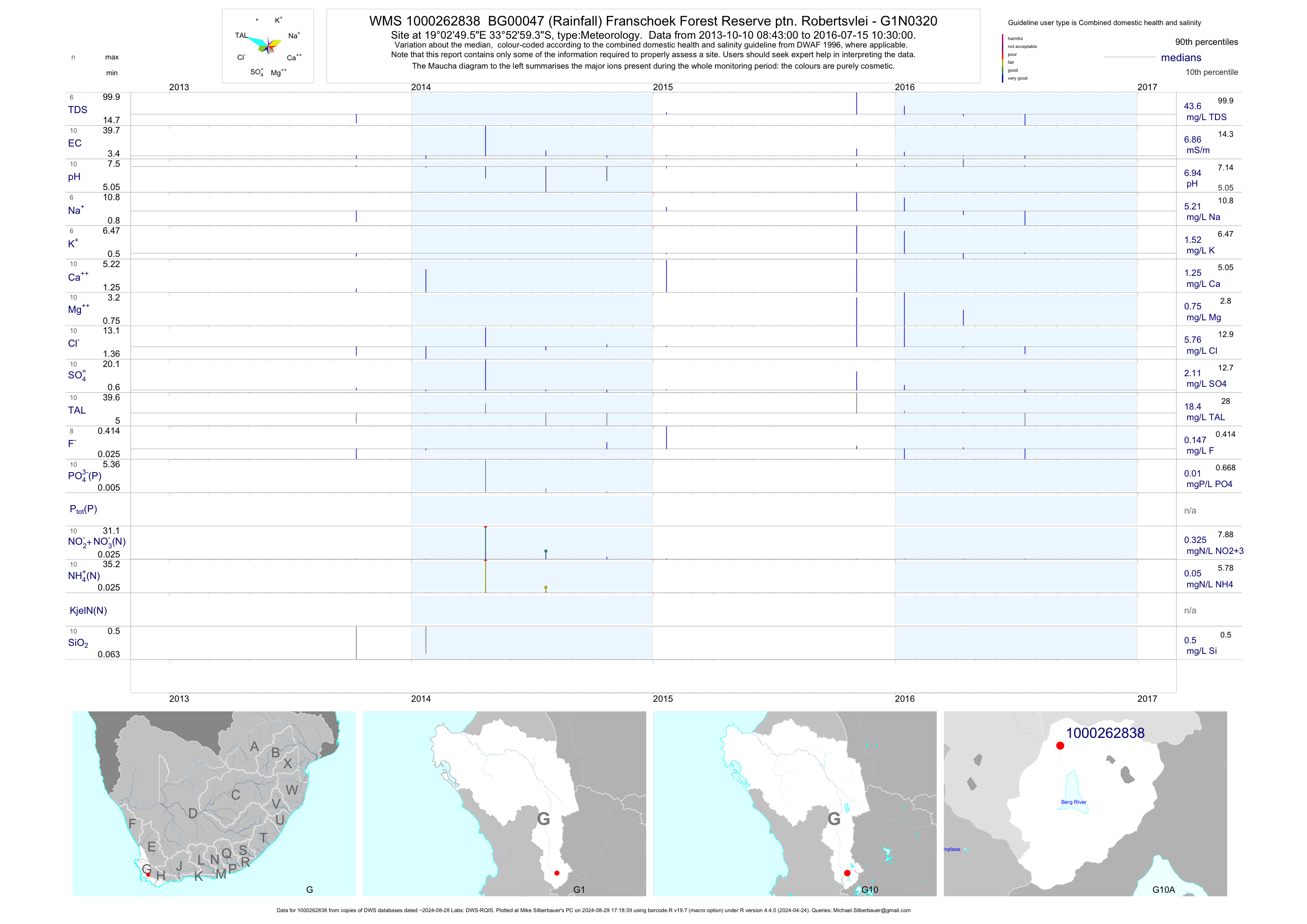
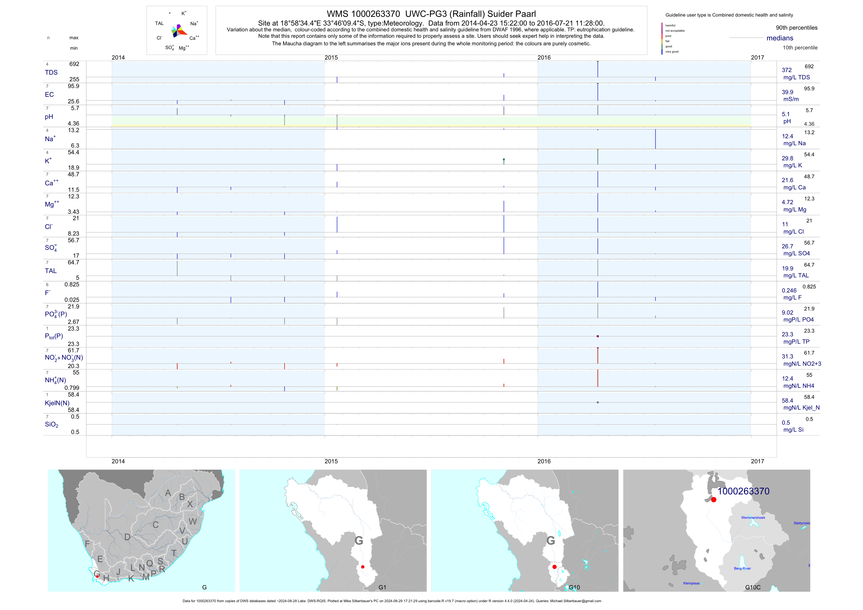
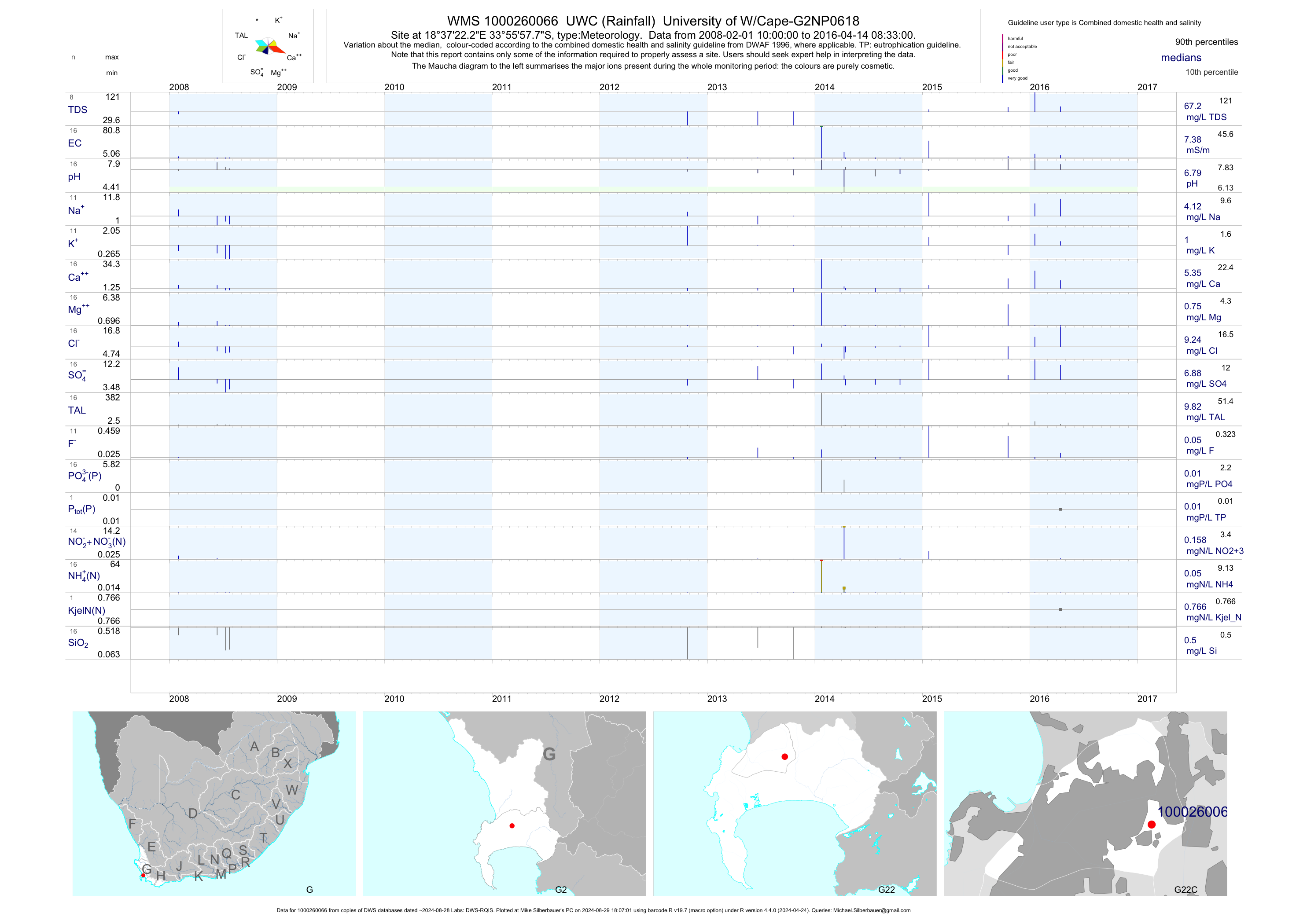
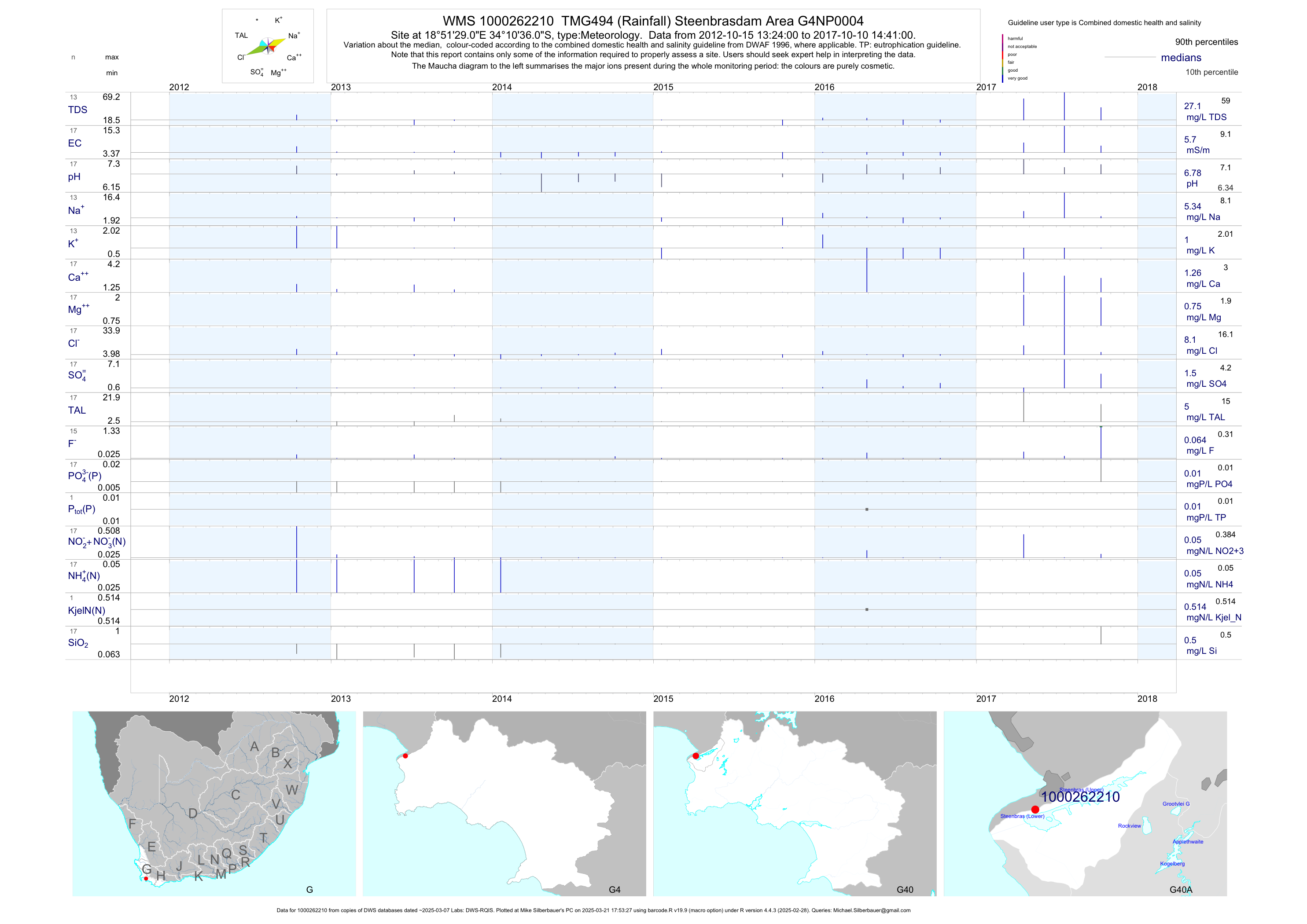