|
The Limpopo Water Management Area (WMA) North, as defined in the NWRS-1 (2004), is the most northern WMA in South Africa.The Limpopo WMA North forms part of the internationally shared Limpopo Basin. The Limpopo River forms the entire length of the international border between the WMA and Botswana and Zimbabwe before flowing into Mozambique. The main rivers in the study area form the six major catchment areas in the Limpopo WMA North which include the Matlabas, Mokolo, Lephalala, Mogalakwena, Sand and Nzhelele. These rivers, together with other smaller tributaries, all flow northwards into the Limpopo River.
Adjacent catchments supplying water to the Limpopo WMA North include the Luvuvhu and Letaba, Olifants, and Crocodile (West) and Marico. No transfers are currently made from the Limpopo WMA North to other WMAs.
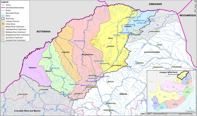
Study Area for the Limpopo WMA North Reconciliation Strategy
A brief overview of each of the six major catchments is provided below along with the future development potential within the catchments and the proposed water resources to meet future demands:
The Matlabas River catchment
The Matlabas River catchment is a dry catchment with non-perennial flow and hence no sustainable yield from surface water. The limited water use in this catchment is mostly from groundwater, which is under-exploited. No major developments and hence limited water demand increases are expected for the catchment. Future domestic water requirements can be supplied from groundwater.
The Mokolo River catchment
The Mokolo River catchment is located in the higher rainfall portion of this WMA and is also the most developed catchment from a water resources point of view. The Mokolo Dam is the largest dam in the WMA and provides water for a multitude of uses, the most important being the supply to the Matimba Power Station and Grootgeluk Coal Mine. There is also a significant amount of irrigation from groundwater. Future developments in the catchment include power stations by Eskom (Medupi Power Station), the potential development of coal-to-liquid fuel facilities by Sasol and the associated growth in mining activities and residential development in the Lephalale area. Groundwater is under-utilised and could be used to support increasing domestic requirements, provided the water quality is acceptable. Furthermore, the Mokolo and Crocodile River (West) Water Augmentation Project (MCWAP) will transfer water from the Crocodile River (West) to augment water supply to new developments in the Lephalale area. Phase 1 of MCWAP comprises of a pipeline parallel to the existing Mokolo pipeline from Mokolo Dam to supply the growing water requirement for the interim period until a transfer pipeline, abstracting water from Vlieëpoort near Thabazimbi in the Crocodile (West) River can be implemented (Phase 2). Water delivery for Phase 1 commenced in late2015 and Phase 2 is planned to supply water by November 2020. This transfer is reserved for in the Crocodile (West) River Water Supply System Reconciliation Strategy.
The Lephalala River catchment
The Lephalala River catchment has limited water resources. Irrigation takes place mainly in the higher rainfall upper reaches, where there are a large number of farm dams, while lower in the catchment irrigators make use of water from alluvial aquifers. Nevertheless, the catchment appears to be stressed and no new allocations should be made for irrigation purposes. Water Conservation and Demand Management (WCWDM) is critical to minimize the deficit in the catchment. The middle reaches of the Lephalala catchment has a high conservation value which is sensitive to development and hence additional water for domestic purposes should be sourced from groundwater should WCWDM not suffice.
The Mogalakwena River catchment
The Mogalakwena River catchment has limited surface water resources but large groundwater resources, which have already been extensively exploited by the irrigation sector. The two major dams in the catchment are Doorndraai Dam in the upper reaches and Glen Alpine Dam in the lower reaches. The catchment is the most densely populated and industrialised in the Limpopo WMA North and includes the towns of Modimolle, Mookgopong and Mokopane. Doorndraai Dam supplies domestic and irrigation requirements and Glen Alpine Dam supplies only irrigation water.
There is a rapid expansion of especially platinum mines in the area and the water supply to these mines must be secured. Additional water resources are groundwater and transfers from the Flag Boshielo Dam in the Olifants River catchment to supply Mokopane. More information in this regard is included in the Olifants River Water Resources Development Project (ORWRDP) as well as the Olifants River Water Supply System Reconciliation Strategy. Provision was made in the Crocodile West River Water Supply System Reconciliation Strategy to transfer additional water to Modimolle and Mookgopong from the Klipvoor Dam or Roodepoort Dam.
The Sand River catchment
The Sand River catchment is the driest catchment in the Limpopo WMA North with very limited surface water resources. However, it has exceptional groundwater reserves which have been fully and possibly over-exploited, mostly by irrigation. The water requirements are large compared to the rest of the WMA, with irrigation again being the largest water user. Urban requirements are supplied mostly from transfers from other WMAs. Polokwane is mostly supplied from transfers from the Dap Naude, Ebenezer dams located in the Luvuvhu and Letaba WMA (as defined in the NWRS-1) and the Olifantspoort weir in the Olifants River Catchment. Louis Trichardt is currently supplied by transfers from Albasini Dam, to be replaced in future by Nandoni Dam, both in the Luvuvhu and Letaba WMA (as defined in the NWRS-1) and included in the Luvuvhu and Letaba Water Supply System Reconciliation Strategy. A number of major developments are anticipated for the Sand River catchment area. These include the Limpopo Eco Industrial Park (LEIP) and the Special Economic Zone (SEZ), both near Musina. Water requirements for these developments have not yet been quantified, but will have to be supplied from sources outside of the Limpopo WMA North. Coal of Africa Limited (CoAL) is planning to develop a number coal mines between Louis Trichardt and Musina. These include the existing Vele project and the new Mopane and Chapudi projects. The water sources of the latter two projects are still to be determined. The Mutasshi/Musina Corridor Bulk Water Supply Feasibility Study have been conducted in 2013 to assess the domestic water demand in the Musina and Makhado Local Municipality areas. The study also includes rough estimates of the water requirements of the aforementioned future developments and augmentation options.
The Nzhelele River and Nwanedzi River catchment
The Nzhelele River catchment is a small catchment dominated by irrigation which is supplied by the Mutshedzi Dam, farm dams, run-of-river in the upper reaches of the catchment, and the Nzhelele Dam (the second largest dam in the WMA) in the lower reaches of the catchment. Groundwater is also extensively used. Much of this irrigation is managed by emerging farmers. There is also a significant amount of afforestation in the high rainfall regions on the slopes of the Soutpansberg Mountains which reduces the runoff.
The Nwanedi River catchment is a small catchment in the north-eastern corner of the WMA characterised by large areas under irrigation (relative to the size of the catchment). The water resources of the area are limited to that provided by a few small dams (Nwanedi and Luphephe twin dams and Cross Dam) and run-of-river abstractions. The catchment is in deficit. This is due to over-allocation or over-development by the irrigation sector.
Major future developments in the Nzhelele and Nwanedi River catchments include CoAL’s Makhado and Generaal coal mining projects north of the Soutpansberg. The Makhado Project is already at Feasibility stage and will possibly be supplied from the Nzhelele Dam Irrigation Scheme through water trading with the irrigation sector – pending the approval of the Water Use Licence. The Mutasshi/Musina Corridor Bulk Water Supply Feasibility Study includes these developments and mentioned the possibility of expanding irrigation in the Nzhelele Valley area should additional water become available.
CLIMATE
The average temperature in the Limpopo WMA North is 20C, with the average maximum monthly temperature being 30C during January and the average minimum monthly temperature being 4C during July. The climate over the WMA is temperate, semi-arid in the south to extremely arid in the north. Mean annual rainfall ranges from 300mm to 700mm with potential evaporation well in excess of the rainfall. Rainfall is seasonal with most rainfall occurring in the summer with thunderstorms. Runoff is low due to the sandy soils occurring over most of the WMA, however, loam and clay are also found in certain areas.
TOPOGRAPHY and GEOLOGY
The topography of the Limpopo WMA North is generally flat to rolling, with the Waterberg on the south and Soutpansberg in the north-east as main topographic features. Grassland and sparse bushveld shrubbery and trees cover most of the terrain.
The southern and western parts of the WMA are mainly underlain by sedimentary rocks, whilst metamorphic and igneous rocks are found in the northern and eastern parts. With the exception of some alluvium deposits and dolomites near Mokopane and Thabazimbi, the formations are mostly not of high water bearing capacity. The mineral rich Bushveld Igneous Complex extends across the south-eastern part of the WMA, and precious metals are mined at various localities throughout the area. Large coal deposits are found in the north-west.
Several wildlife and nature conservation areas have been proclaimed in the WMA,
of which the Nylsvley Nature Reserve, Mapungubwe National Park and Marekele
National Park are probably the best known.
POPULATION
About 3.5% of the country’s population live in the Limpopo WMA North of which
approximately 80% is classified as rural. Approximately 760 rural villages are
scattered throughout the WMA, more notably in the central parts, with little
local economic activity to support these population concentrations. Polokwane is
the largest urban centre in the WMA. Other main towns are Musina, Louis
Trichardt, Mokopane, Mookgopong and Modimolle.
ECONOMIC ACTIVITIES
Only 1.5 % of the Gross Domestic Product (GDP) of the country originates from the Limpopo WMA North. Economic activities are centred around the main urban areas of Polokwane, Lephalale and Mokopane and revolve mainly around agriculture, mining and power generation. Agriculture includes the production of cotton (50% of the national annual cotton yield), grain sorghum, tobacco and citrus, however, a large part of the population relies on subsistence agriculture. Mining is driven by the large coal and platinum deposits in the Lephalale area and south-eastern parts of the WMA respectively. Power generation include the Matimba Power Station and the Medupi Power Station (under construction).
LAND-USE AND DEVELOPMENT
Irrigation developments occur at various locations in the Limpopo WMA North, such as the Waterberg area, the Sand River catchment and along the Limpopo River, with much of the water being supplied from farm dams and groundwater. Small areas of commercial forest are found in the high rainfall parts of the Soutpansberg near Louis Trichardt. Most of the WMA remains under natural vegetation, with livestock and game farming as main activities. Severe overgrazing is prevalent in many areas.
Mining is a strategic water user with a variety of minerals found mainly in the eastern and southern part of the WMA. Recent developments include large expansions in mining activities with respect to the platinum group metals, mainly in the vicinity of Mokopane and extending both east and westward along the Bushveld Igneous Complex. Extensive future coal mining development is anticipated between the Louis Trichardt and Musina.
Approximately 50% of the urban population is concentrated in Polokwane. Other towns, Musina, Louis Trichardt, Mokopane, Mookgopong and Modimolle, are all situated in areas where water is limited.
|