Module 1: Technical Feasibility Study
Study Approach
The Technical Feasibility Study is being undertaken in two separate phases, as follows:
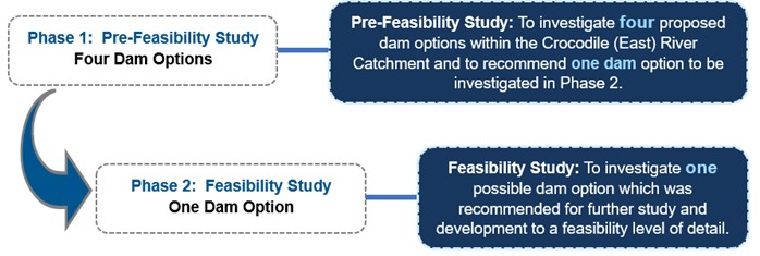
Phase 1: Pre-Feasibility Study
The Pre-Feasibility Study (Phase 1) will be undertaken for the above-mentioned four proposed dams within the Crocodile (East) River Catchment.
A long-term regional water supply solution for the Crocodile (East) River Catchment is required and taking cognizance of the significant water deficits in the Crocodile (East) River Catchment it is possible that the implementation of more than one dam will be required. Therefore, a ranking/scoring system (based on a multi-criteria decision matrix) rather than an elimination process will be adopted during the execution of the Pre-Feasibility Study.
A multi-criteria decision matrix (ranking system) will be developed which will be applied to all four dams to enable a uniform comparison with the objective to identify the most feasible option (highest ranking/scoring). The criteria will typically include the following:
- Environmental impacts
- Yield analysis (Water Resources)
- Geological and geotechnical considerations
- Engineering (dam type, conveyance infrastructure, etc.)
- Capital expenditure (CAPEX) and operational expenditure (OPEX)
- Engineering economic analysis (Unit Reference Values)
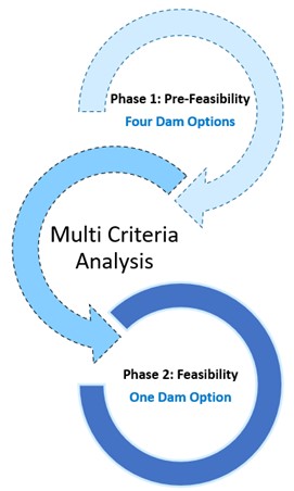
For each of the above-mentioned criteria an appropriate ranking/scoring system (0 = worst, 5 = best) will be developed. In the scoring system each of the criteria will be assigned the same weight in the determination of the aggregated merit score of each dam option.
The highest ranking / scoring dam option will be selected and recommended for further investigation and development at feasibility level.
Phase 2: Feasibility Study
Under the Phase 1: Pre-Feasibility Study, one of the possible four dam options will be selected and recommended for further study and development to a feasibility level of detail in the Phase 2: Feasibility Study.
The work will be done at a level of detail that will allow the proposed scheme to be ready for implementation in the shortest possible time upon the completion and conclusion of this Study.
In order to expedite the planning for a dam(s) in the Crocodile River Catchment, the Feasibility Study has been divided in two separate interactive and concurrently running modules, as follows:
- Module 1: Technical Feasibility Study
- Module 2: Environmental Impact Assessment
Study Area
The Crocodile (East) River Catchment in Mpumalanga is located in the north-east of the country and forms part of the larger Inkomati River Basin. The water of the Inkomati River Basin is shared between Mozambique, South Africa and Eswatini.
The Crocodile River Catchment is rural in nature, with agriculture being the main economic activity. The high rainfall escarpment catchments of the Upper and Middle Crocodile and Kaap catchments have significant areas of commercial forestry.
A map of the Study Area is included in Figure 2-1.
The Crocodile (East) River Catchment comprises of the following four tertiary catchments as indicated in Figure 2-2:
- Upper Crocodile Catchment (X21)
- Middle Crocodile Catchment (X22)
- Lower Crocodile Catchment (X24)
- Kaap Catchment (X23)
Important tributaries of the Crocodile River include the following:
- Kaap River
- Elands River
- Nels River
- White River
The only major dam in the catchment is the Kwena Dam in the Upper Crocodile River Catchment. The dam is approximately 60 km west of Mbombela on the main stem of the Crocodile East River or in the upper reaches of the Crocodile East Catchment. The dam is far from the water demand centers and therefore makes it difficult to regulate and manage water distribution to supply demands as required by the users.
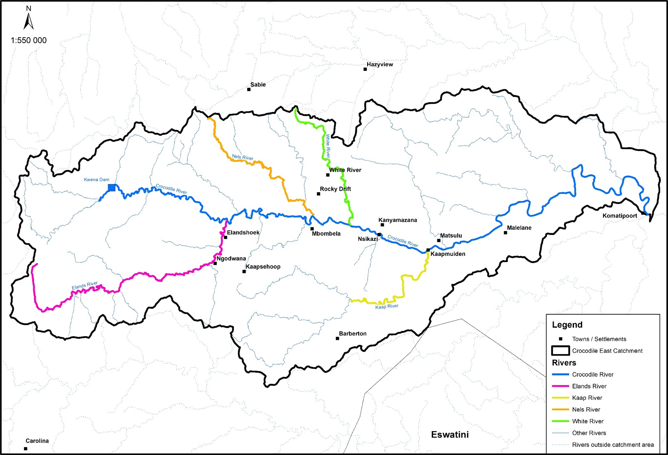
Figure 2-1: Crocodile River Catchment
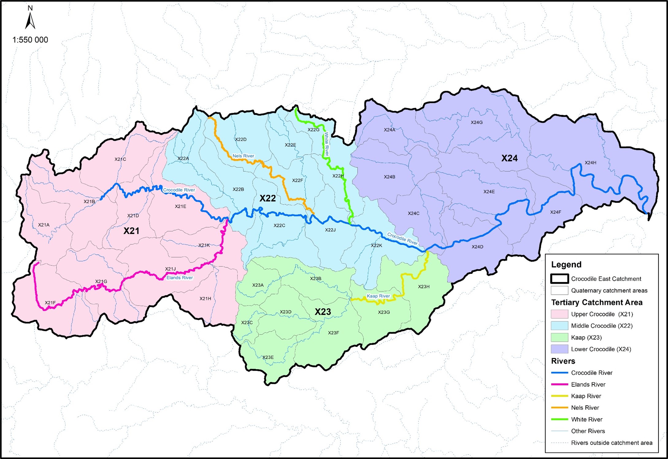
Figure 2-2: Crocodile East River: Tertiary Catchments
Previous Studies
The following previous studies and investigations related to the Study were completed.
- Interim IncoMaputo Agreement (IIMA), Tripartite Technical Committee (TPTC) Mozambique, South Africa & Swaziland ? August 2002.
- Inkomati Water Management Area Internal Strategic Perspective (ISP) PWMA 05/000/00/0303 ? March 2004.
- Crocodile (East) River Development, Reconnaissance Study, PD Naidoo & Associates ? September 2008.
- Inkomati Water Availability Assessment Study, Main Report (IWAAS) PWMA 05/X22/00/0808 ? June 2009.
- Progressive Realisation of the IncoMaputo Agreement (PRIMA): Basin Management Alternatives and Feasibility Report: Part B: Inkomati River Basin, Report No: Implementation Activities and Action Plan (IAAP) 3 ? April 2011.
- Inkomati Water Management Area: Modelling Support for Licensing Scenarios: Identification of Dam Sites on Crocodile River (East) ? 1st Draft 2011.
- Comprehensive Reserve Determination Study for Selected Water Resources (Rivers, Groundwater and Wetlands) in the Inkomati Water Management Area, Mpumalanga.
- Development of Real-Time Operating Rules for the Crocodile River Catchment.
- Water Requirements and Availability Reconciliation Strategy for the Mbombela Local Municipality ? February 2014.
- Continuation of Water Requirements and Availability Reconciliation Strategy for the Mbombela Municipal Area ? October 2020.
The previous studies and investigations recommended potential dam options within the Crocodile (East) River Catchment further study.
Overview of Study Tasks
The proposed work has been structured and broken down into various tasks and subtasks, which are as follows:
Phase 1: Pre-Feasibility Study (Four Dam Options)
|
Task |
Deliverable |
| 1 |
Study Inception |
Inception meeting Site visits to the four dam options Inception Report |
| 2 |
Ecological Consequences in Terms of the National Water Resource Class, the Target Ecological Category and the Reserve |
Downstream Ecological Consequences and Potential Impacts on the National Water Resource Class Report |
| 3 |
Perform/Review Historic Yield Analysis |
Yield Analysis Report |
| 4 |
Environmental Screening and Identification of Fatal Flaws |
Environmental Screening Report |
| 5 |
Perform/Review Geotechnical and Material Investigations |
Geotechnical and Material Investigations Report |
| 6 |
Engineering Investigation |
Engineering Investigation Report |
| 7 |
Topographical Survey and Mapping |
Lidar DTM data, Contour and Orthophoto generation, Topographical detail mapping |
| 8 |
Proposed Scheme Configurations (Engineering Investigation) |
Proposed Scheme Configurations Report |
| 9 |
Engineering Economic Analysis |
Engineering Economic Analysis Report |
| 10 |
Multi-Criteria Analysis |
Multi-Criteria Analysis of Dam Options Report |
| 11 |
Pre-Feasibility Study Report |
Pre-Feasibility Study Report which includes information on the findings of the reports mentioned above. |
Phase 2: Feasibility Study (Recommended/Selected Dam Option)
|
Task |
Deliverable |
| 1 |
Environmental Screening |
Environmental Screening Report |
| 2 |
Water Resources, including:
- Determine Existing and Future Water Demands
- Yield Analysis with the Water Resource Yield Model
- Future Water Balance for the Project
- Development of Short-term Stochastic Yield Reliability Curves
- Water Resources Planning Model (WRPM)
- Assessment of the Potential for Hydropower Generation at the Dam (Water Resources)
|
Water Resources Report |
| 3 |
Ecological Consequences in Terms of the National Water Resource Class, the Target Ecological Category and the Reserve |
Ecological Consequences of Dam Operational Scenarios Report |
| 4 |
Socio-Economic Impacts |
Socio-Economic Impacts Report |
| 5 |
Engineering Investigation, including:
- Topographical Surveys and Mapping
- Geological and Geotechnical Investigation
- Geomorphological and Seismic Investigation
- Flood Studies
- Feasibility Design of the Selected Scheme
- Construction Programming and Costing
- Access and Advanced Infrastructure
- Flood and Backwater Calculations for the Dam
- Climatological Data for the Construction Site
- Water Quality and Limnology
- Sediment Yield and Sedimentation Investigation
- Land Requirements and Associated Costs
- Assessment of the Potential for Hydropower Generation at the Dams (Engineering Investigation)
- Costing (CAPEX and OPEX) of the Project
- Engineering Economic Analysis
|
Engineering Investigation Report |
| 6 |
Implementation Actions |
Project Implementation Programme |
| 7 |
Record of Implementation Decisions |
Record of Decisions |
| 8 |
Institutional, Financial and Operational Aspects |
Institutional, Financial and Operational Aspects Report |
| 9 |
Feasibility Study Report |
Feasibility Study Report which includes information on the findings of the reports mentioned above. |
Dam Options
The following four proposed dam sites were visited at the end of 2023 and below are also some initial observations.
- Mountain View Dam on the Kaap River
- Montrose Dam on the Crocodile East River
- Boschjeskop Dam on the Nels River
- Strathmore Off-Channel Storage Dam, near the confluence of the Kaap and Crocodile Rivers
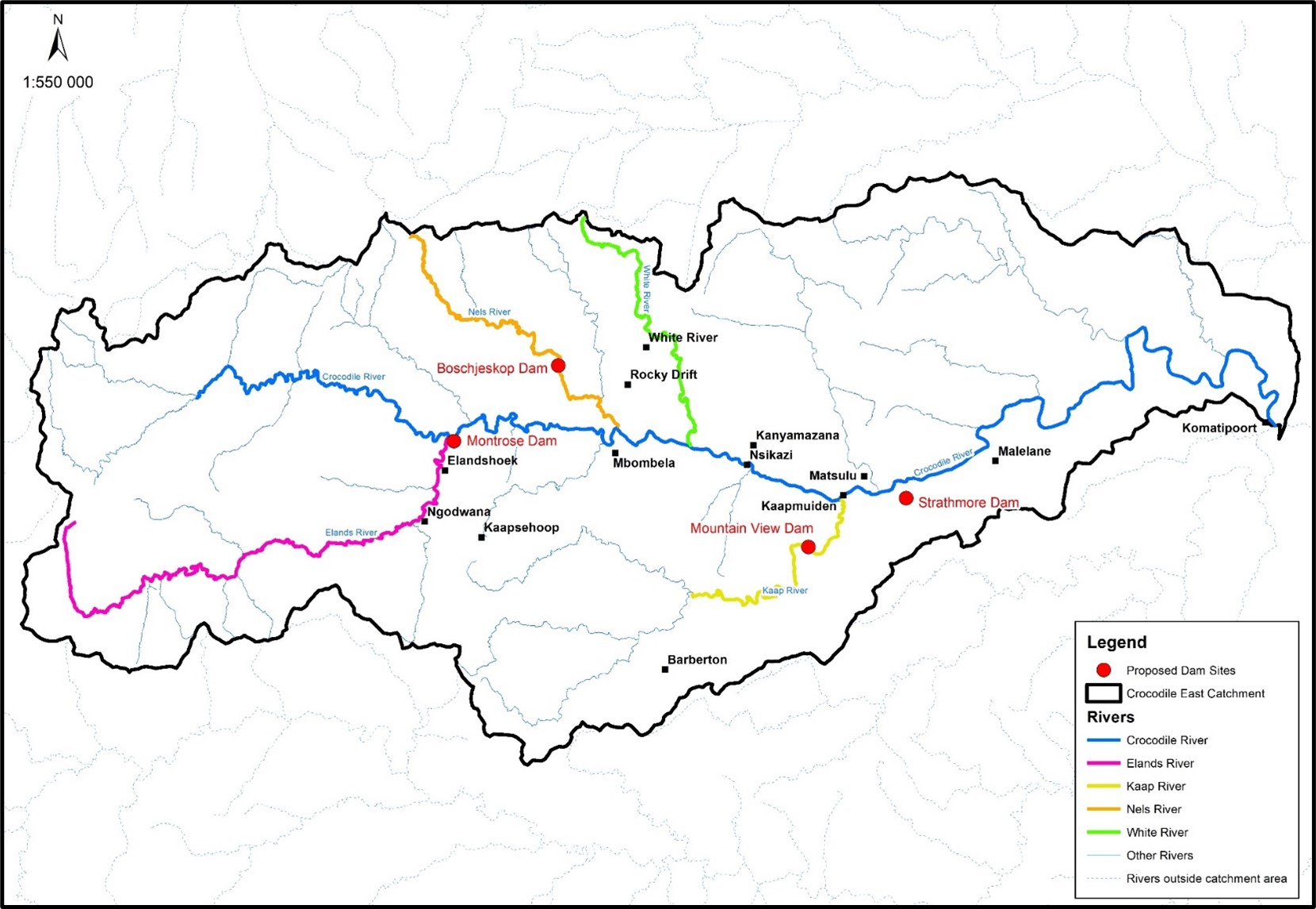
Figure 5-1: Locality of Four Proposed Dam Sites
Montrose Dam
The proposed dam site is located in the Crocodile River some 2 km downstream of the confluence of the Elands and Crocodile Rivers. The approximate site co-ordinates of the proposed Montrose Dam are:
Latitude 25?27?17? and Longitude 30?43?34?
Access was gained to the right flank via the Rivulets gravel road which eventually follows the railway track in a southern direction.
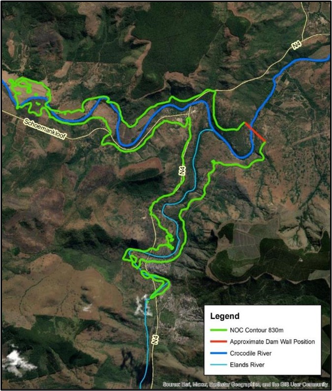
The Montrose dam site has an asymmetrical shape with the right flank significantly flatter than the left flank. Whilst vehicle access is possible from the right flank, the left flank access is difficult without any paths or tracks noticeable. It will be difficult to establish drilling equipment on the steep left flank. Widespread granite rock outcrops were however observed on the left flank.
The right flank has scattered granite rock outcrops and the rock weathering profile is clearly very irregular. The river section comprises a wide (approximately 50 m) alluvial terrace on the right bank with no rock outcrops visible in the river channel and rest of the river section. Engineering geological investigations at Montrose will have to comprise a combination of geophysical surveys (electric resistivity on the flanks and seismic refraction in the river section) before drilling be commenced. The main objective of the geophysical surveys would be to identify the best location for a dam site in terms of founding. A potentially suitable area for a rock quarry was identified on the right flank approximately 600 m downstream of the Elands River confluence.
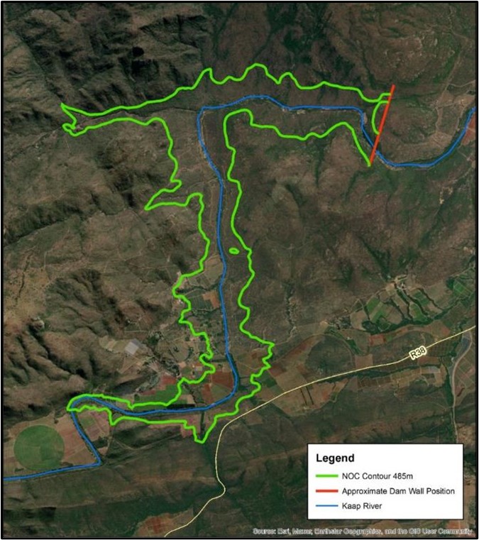
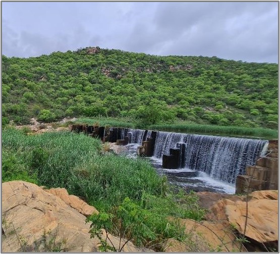
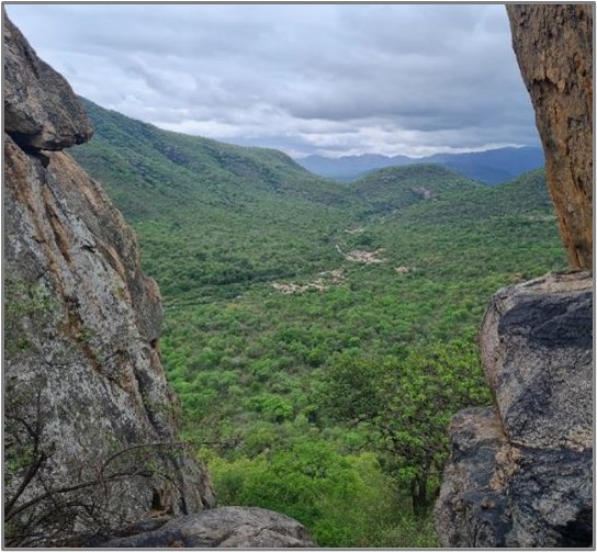
Mountain View Dam
The Mountain View Dam site is situated on the Kaap River approximately 10 km south-west of Kaapmuiden and near the end of a steeply sided valley on the Kaap River (?)10 km upstream of the confluence with the Crocodile River. The approximate site co-ordinates of the proposed Mountain View Dam are:
Latitude 25?36?45? and Longitude 31?16?15?
Access was gained via the Esperado Road which turns off from the R38 Road to Barberton approximately 9.3 km from the N4. Access could be gained using a farm track that leads to the canal offtake on the left river bank, approximately 170 m below the small existing weir. Access to the upper left was possible by means of an existing track that was constructed as part of the exploration drilling programme in the nineteen sixties. The track extends all the way to the saddle on the upper left flank.
 |
 |
Water in the weir dams up within the river channel section for a distance of about 640 m where a very prominent granite rock outcrop forms an impressive continuous rock outcrop in the river section of approximately 250 m x 90 m, at the upstream end of the prominent gorge. Due to the presence of the weir and widespread water upstream of it, access for geophysical surveys and drilling operations is deemed very difficult.
The right flank is very steep and characterised by virtually continuous rock outcrops, giving rise to near-vertical rock cliff faces in places. The closest existing farm track to the upper parts of the right flank is more than 1 km. The right flank is not accessible for geophysical surveys except at the upper portions. The same goes for drilling.
Widespread rock in the dam basin offers several rock quarry site opportunities, particularly on the right flank. The reservoir area contains steep valley slope of more than 1V:2H in places and reservoir slope stability will have to be investigated as part of the Study.
Boschjeskop Dam
The Boschjeskop Dam site is located 16 km to the north-west of Mbombela. The approximate site co-ordinates of the proposed Boschjeskop Dam are:
Latitude 25?21?07? and Longitude 30?52?21?
Access to the site is relatively easy via a secondary gravel road that turns off from the R37 heading northwards from Mbombela to Sabie.
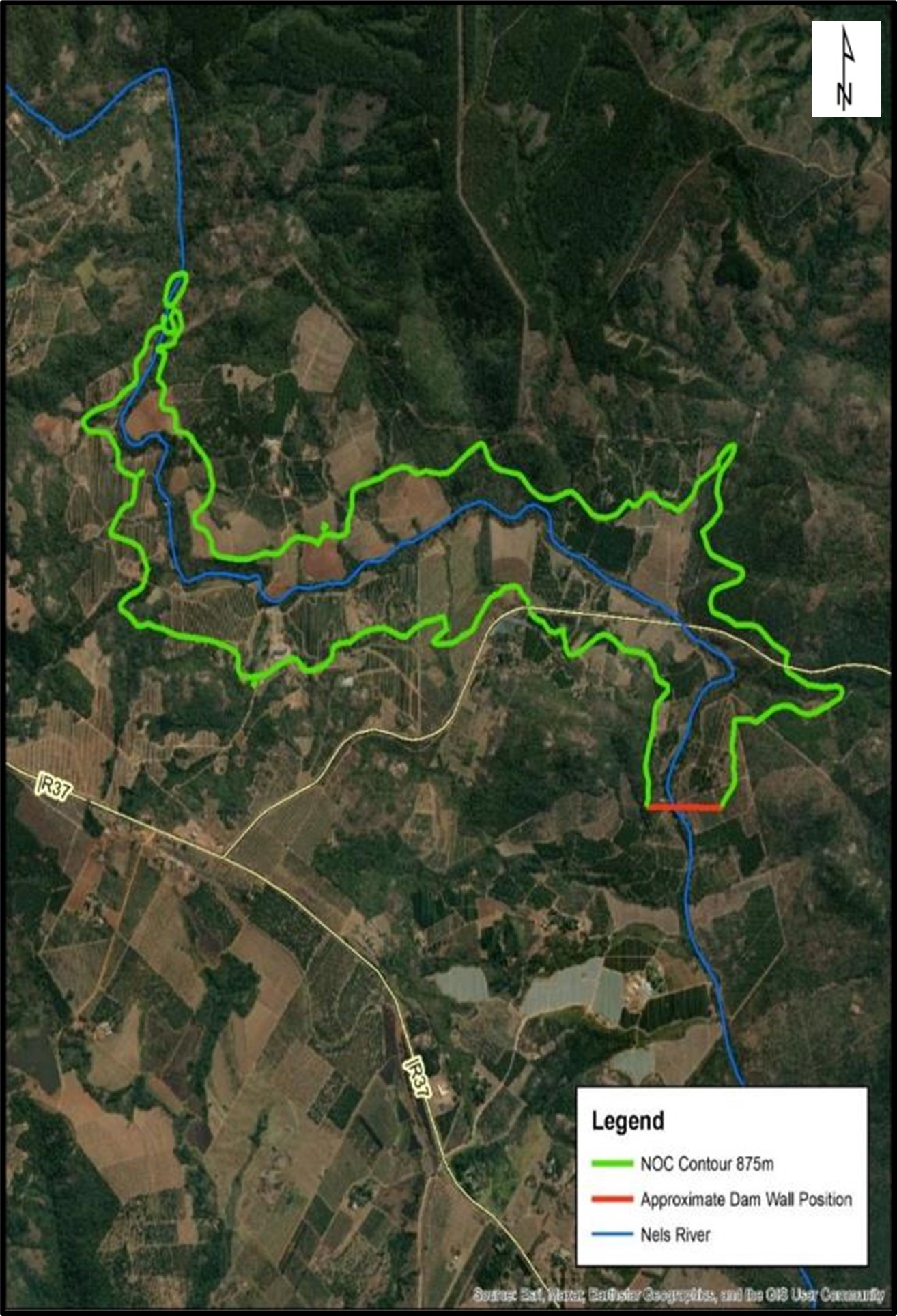
The site has an asymmetrical shape with a steeper right flank that is covered by scattered granite gneiss outcrop. A distinct north-south striking shear zone intersects the upper right flank. This feature is easily recognised by widespread pegmatite and vein quartz which also form somewhat of a ridge.
The river section is densely vegetated mostly by large indigenous trees, but contains scattered prominent granite gneiss rock outcrops. Irregular rock profile is expected in the river section although mostly shallow rock.
The flat left flank is covered by a well-developed clayey sand surface layer (hillwash) underlain by deeply weathered granite.
Access to the entire site is good. Extensive use of geophysical surveys will be required to delineate the concrete spillway option. Earth embankment wall will be required for the flat right flank. The hillwash and residual granitic soils has a large distribution in the dam basin which should be well suited for embankment construction.
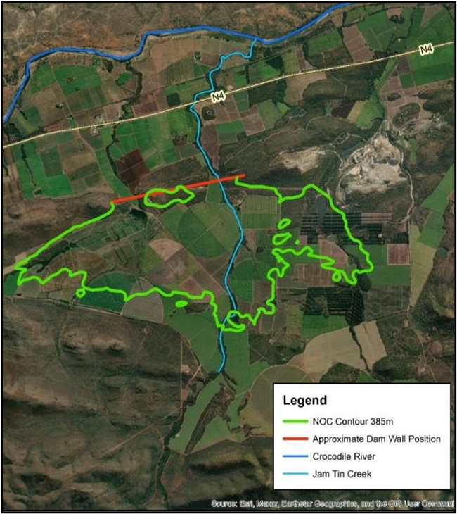
Strathmore Dam
The Strathmore Dam site is located on the southern side of the N4 national highway halfway between Kaapmuiden and Malelane. The dam is to be constructed in a range of hills aligned more-or-less east-west and parallel to the N4 highway. The dam will require at least two separate dam walls.
The approximate site co-ordinates of the proposed Strathmore Off-Channel Dam are :
Latitude 25?36?45? and Longitude 31?16?15?
The approximate site co-ordinates of the second wall are:
Latitude 25?32?07? and Longitude 31?25?31?
Access to the site is easy via farm access road from the N4 road which occurs approximately 1.5 km north of the dam site.
 |
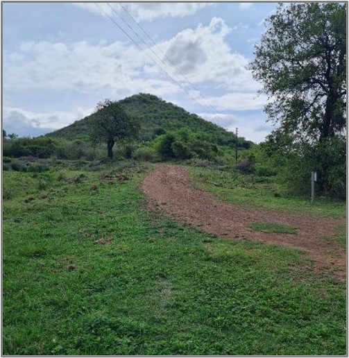 |
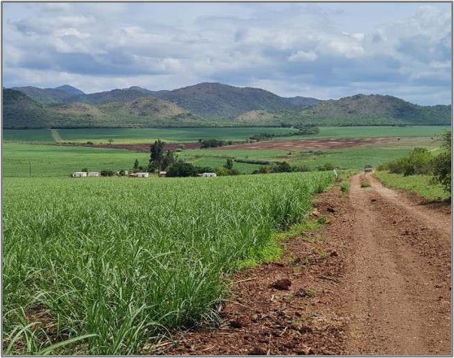
Strathmore Dam Site is an off-channel dam straddling two north-flowing streams. These are separated by a low hill which forms part of a distinct almost east-west striking low hill range. A third stream flows northwards along the far eastern portion of the reservoir (Salt Creek) which will also require a saddle dam pending the reservoir level. The entire reservoir area is under cultivation, mostly sugar cane.
The dam sites positions are not well defined and generally lack distinct rock outcrop, although some areas of shallow rock are expected. The rock mass is generally closely jointed and possibly highly pervious. Extensive foundation grouting is foreseen to render relatively impervious foundations. Geotechnical foundations for this dam site will require geophysical surveys combined with rotary cored drilling particularly to determine rock mass permeability and grouting requirements. Large reserves of clayey soils are present in the basin for embankment construction.
A large magnesite mine is situated to the north-east of the dam. The presence of the old mining pits/mine concession area will limit the reservoir level.