Resource water quality data for region K.

Resource water quality data for region K. |
|
| Water quality | Description | Type | n | First date | Last date | med EC | Flow, if any |
Latitude | Longitude | ||
|---|---|---|---|---|---|---|---|---|---|---|---|
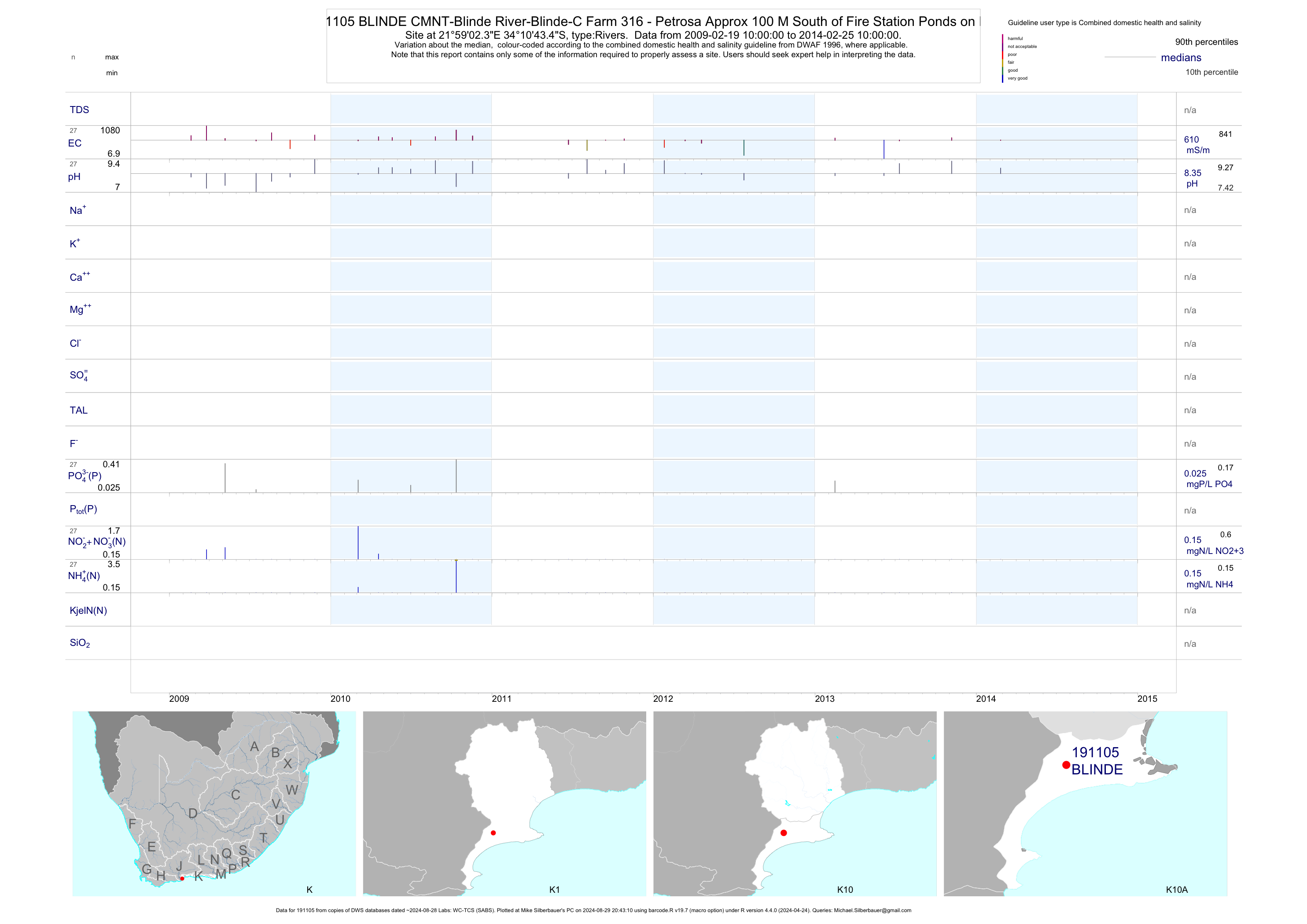
| K10 191105 | plot | data | CMNT-Blinde River-Blinde-C Farm 316 - Petrosa Approx 100 M South of Fire Station Ponds on Blinderivi | Rivers | 38 | 2009-02-19 | 2014-02-25 | 610 | BLINDE | -34.17872 | 21.98399 |
| K10 191106 | plot | data | CMNT-Blinde River-Blinde-D Farm 316 - Petrosa Approx 70 M South of N2 on Blinderivier | Rivers | 39 | 2009-02-19 | 2014-02-25 | 616 | BLINDE | -34.18038 | 21.98380 |
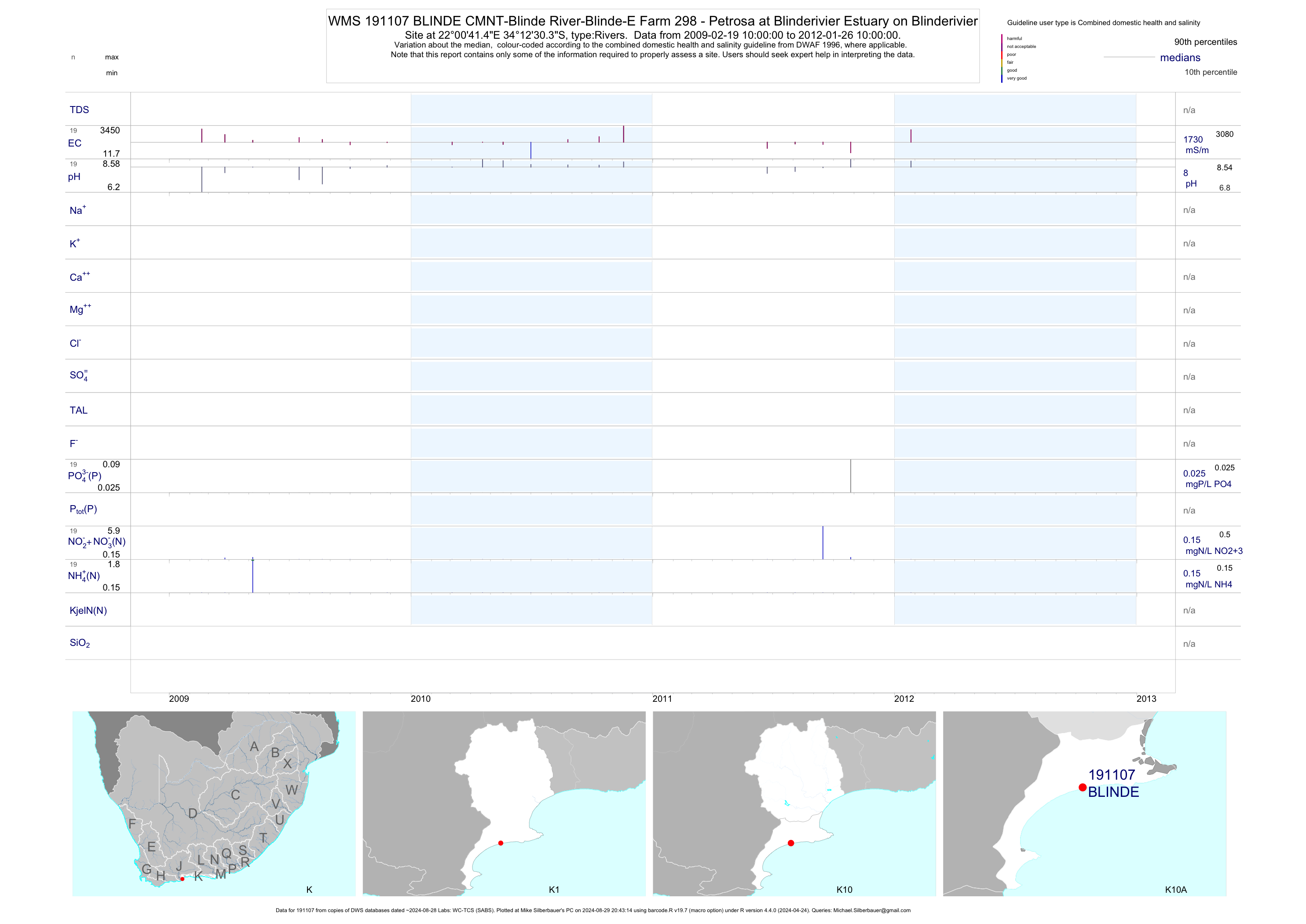
| K10 191107 | plot | data | CMNT-Blinde River-Blinde-E Farm 298 - Petrosa at Blinderivier Estuary on Blinderivier | Rivers | 19 | 2009-02-19 | 2010-07-05 | 1730 | BLINDE | -34.20843 | 22.01151 |
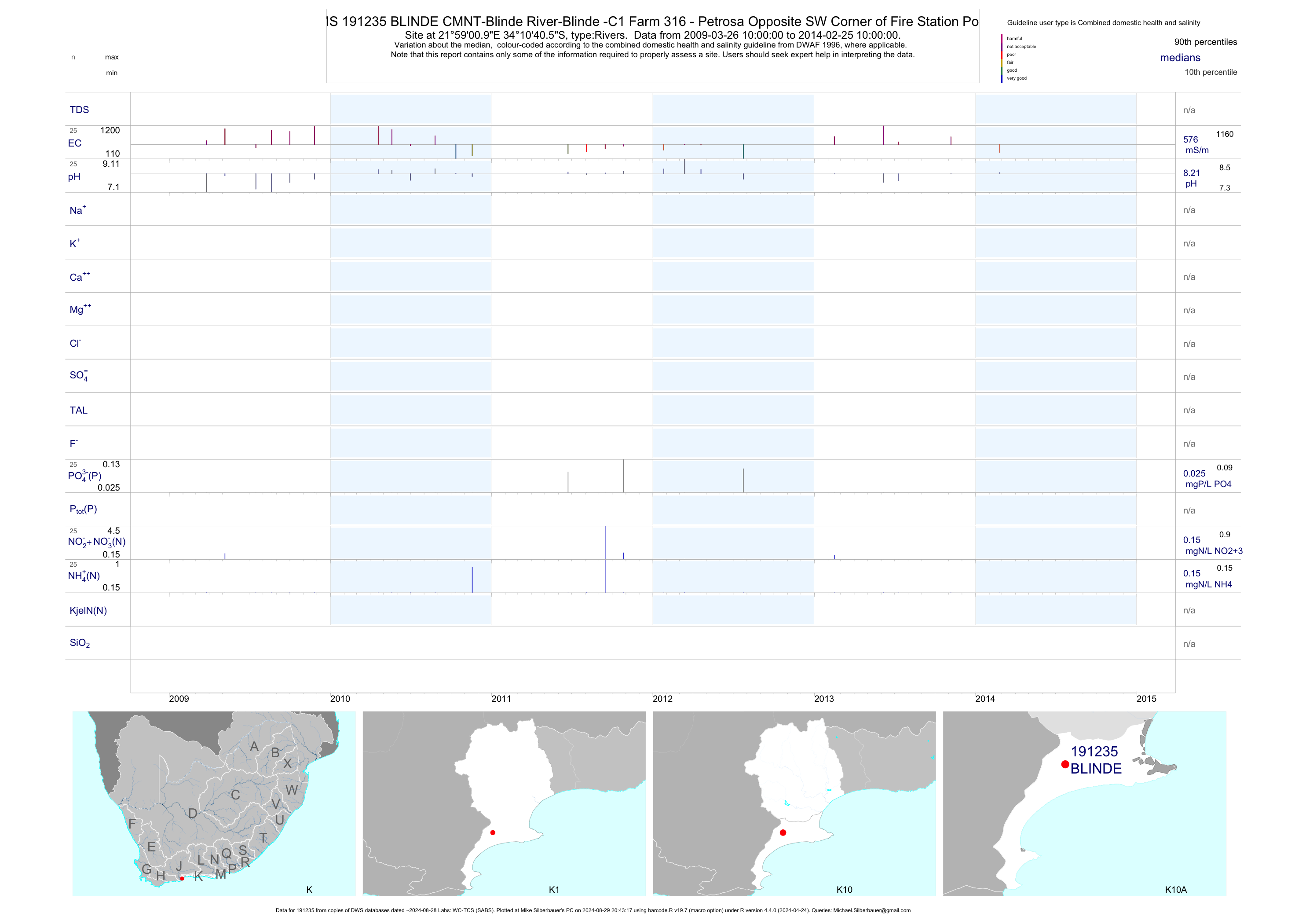
| K10 191235 | plot | data | CMNT-Blinde River-Blinde -C1 Farm 316 - Petrosa Opposite SW Corner of Fire Station Ponds | Rivers | 35 | 2009-03-26 | 2014-02-25 | 576 | BLINDE | -34.17793 | 21.98359 |
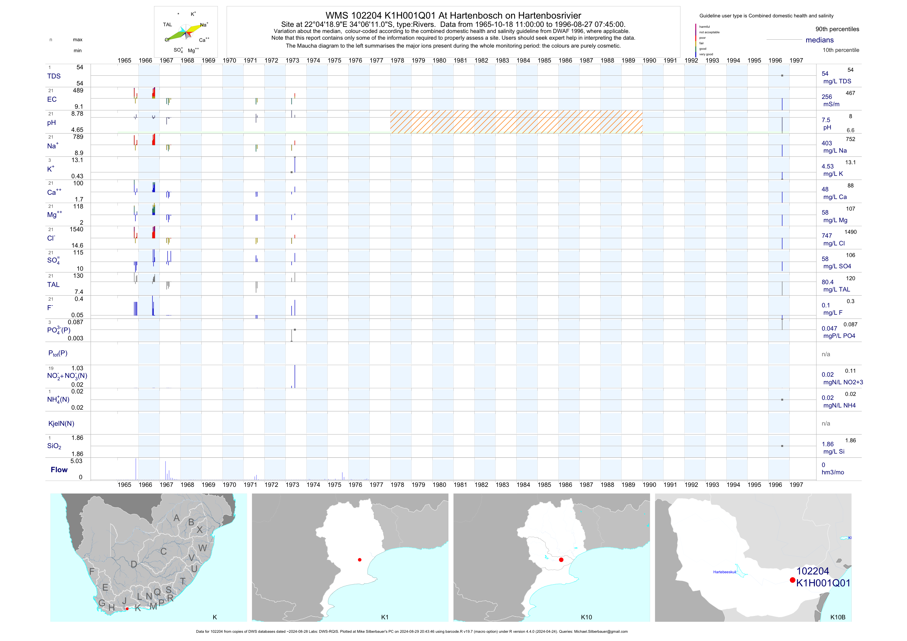
| K10 102204 | plot | data | At Hartenbosch on Hartenbosrivier | Rivers | 21 | 1965-10-18 | 1996-08-27 | 256 | K1H001 | -34.10306 | 22.07194 |
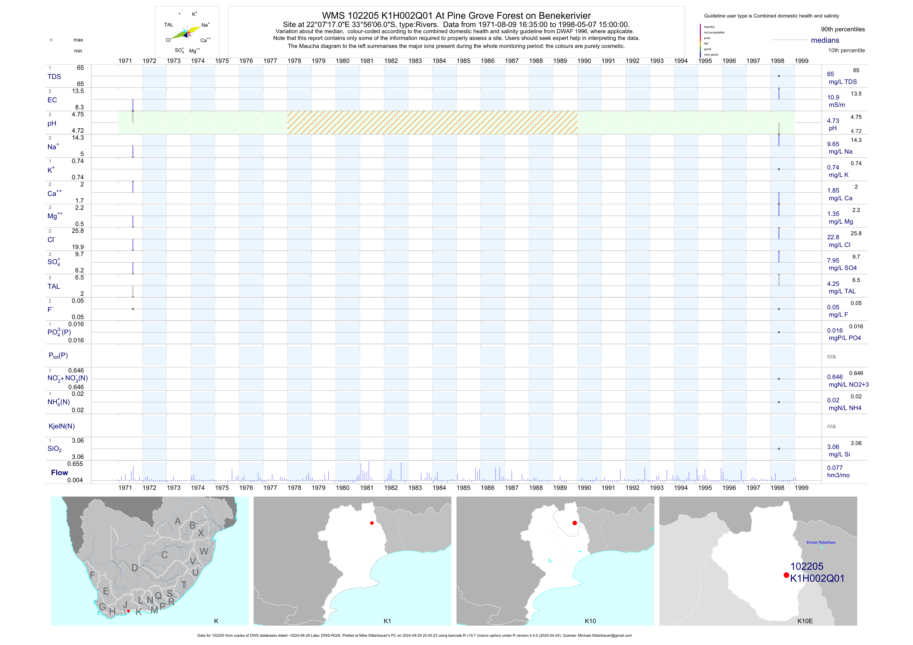
| K10 102205 | plot | data | At Pine Grove Forest on Benekerivier | Rivers | 2 | 1971-08-09 | 1998-05-07 | 11 | K1H002 | -33.93500 | 22.12139 |
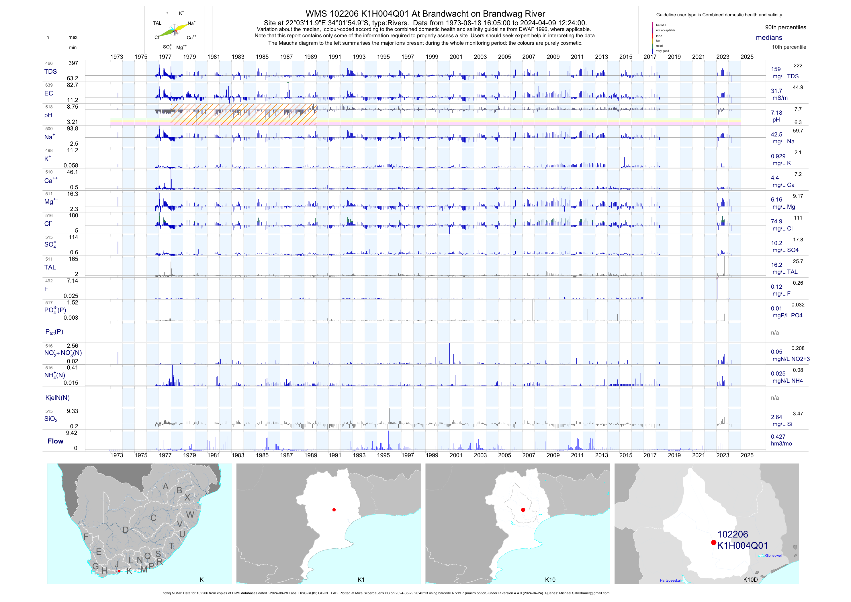
| K10 102206 | plot | data | At Brandwacht on Brandwag River (ncwq NCMP) | Rivers | 631 | 1973-08-18 | 2018-06-05 | 32 | K1H004 | -34.03194 | 22.05333 |
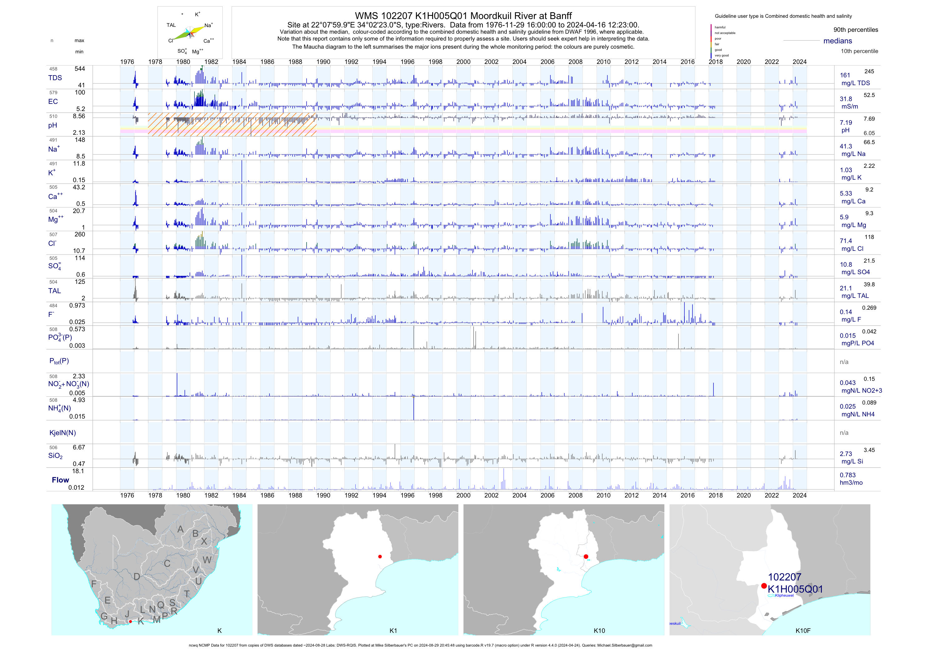
| K10 102207 | plot | data | Moordkuil River at Banff (ncwq NCMP) | Rivers | 573 | 1976-11-29 | 2018-06-05 | 32 | K1H005 | -34.03972 | 22.13333 |
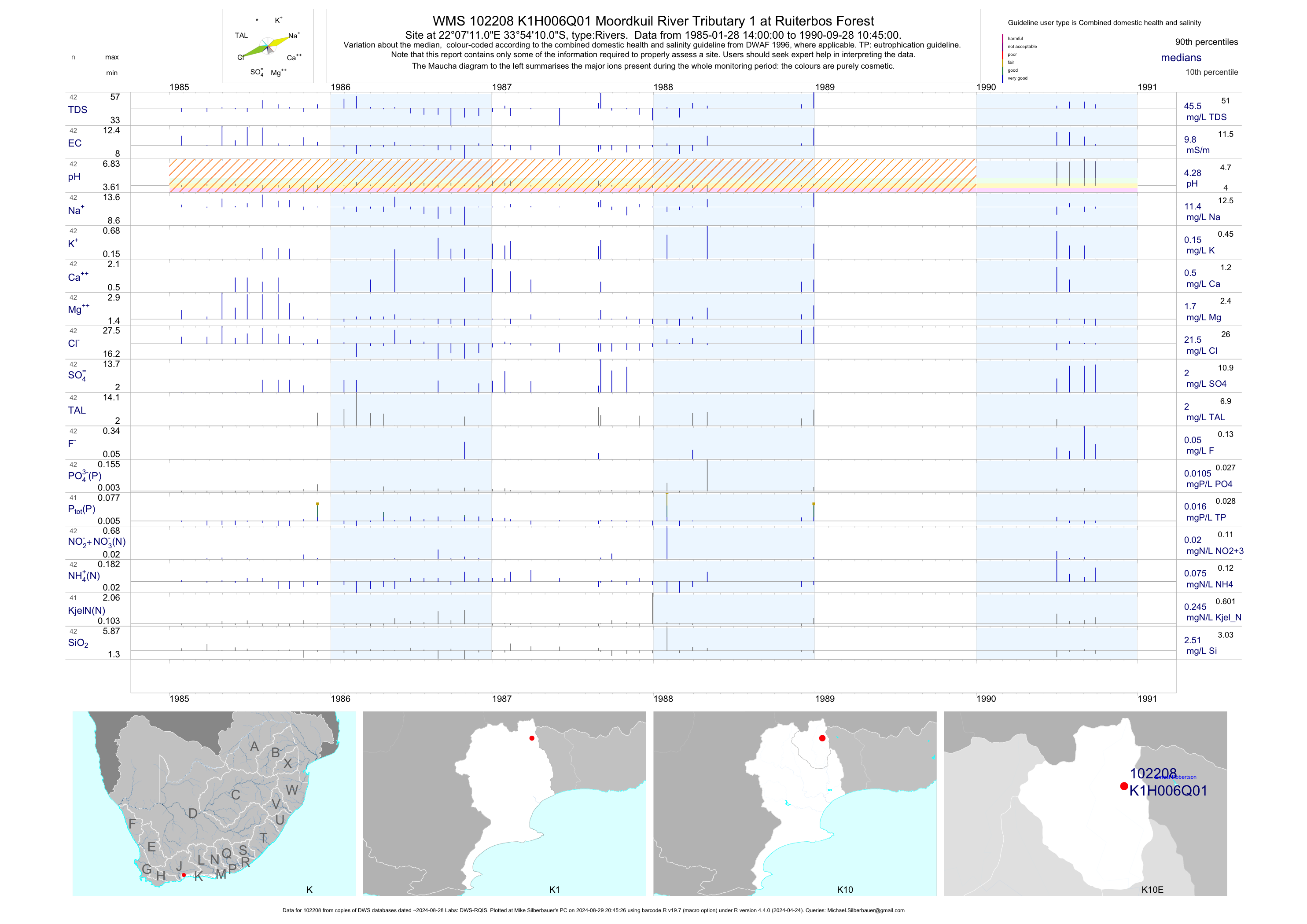
| K10 102208 | plot | data | Moordkuil River Tributary 1 at Ruiterbos Forest | Rivers | 42 | 1985-01-28 | 1990-09-28 | 10 | K1H006 | -33.90278 | 22.11972 |
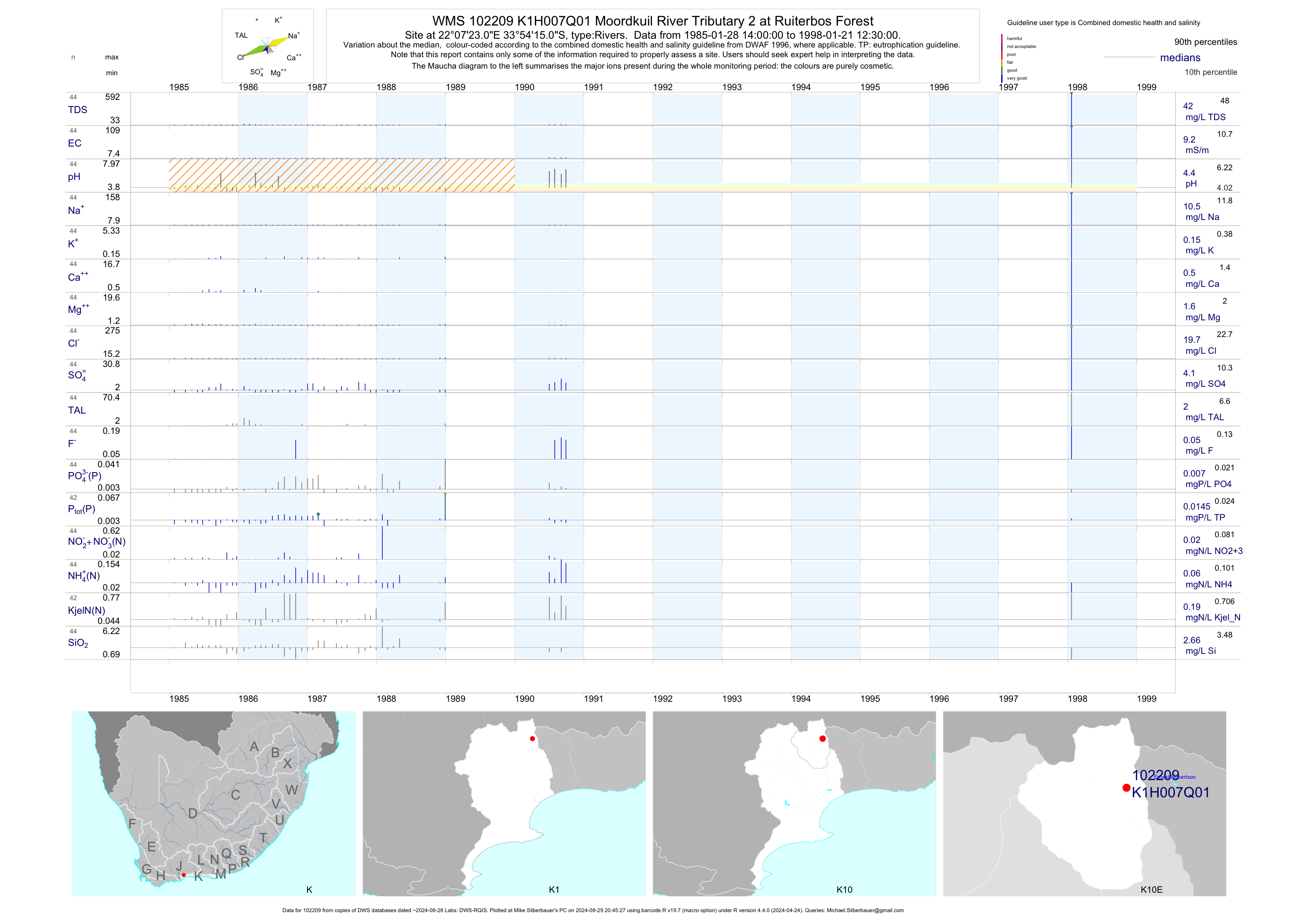
| K10 102209 | plot | data | Moordkuil River Tributary 2 at Ruiterbos Forest | Rivers | 44 | 1985-01-28 | 1998-01-21 | 9 | K1H007 | -33.90417 | 22.12306 |
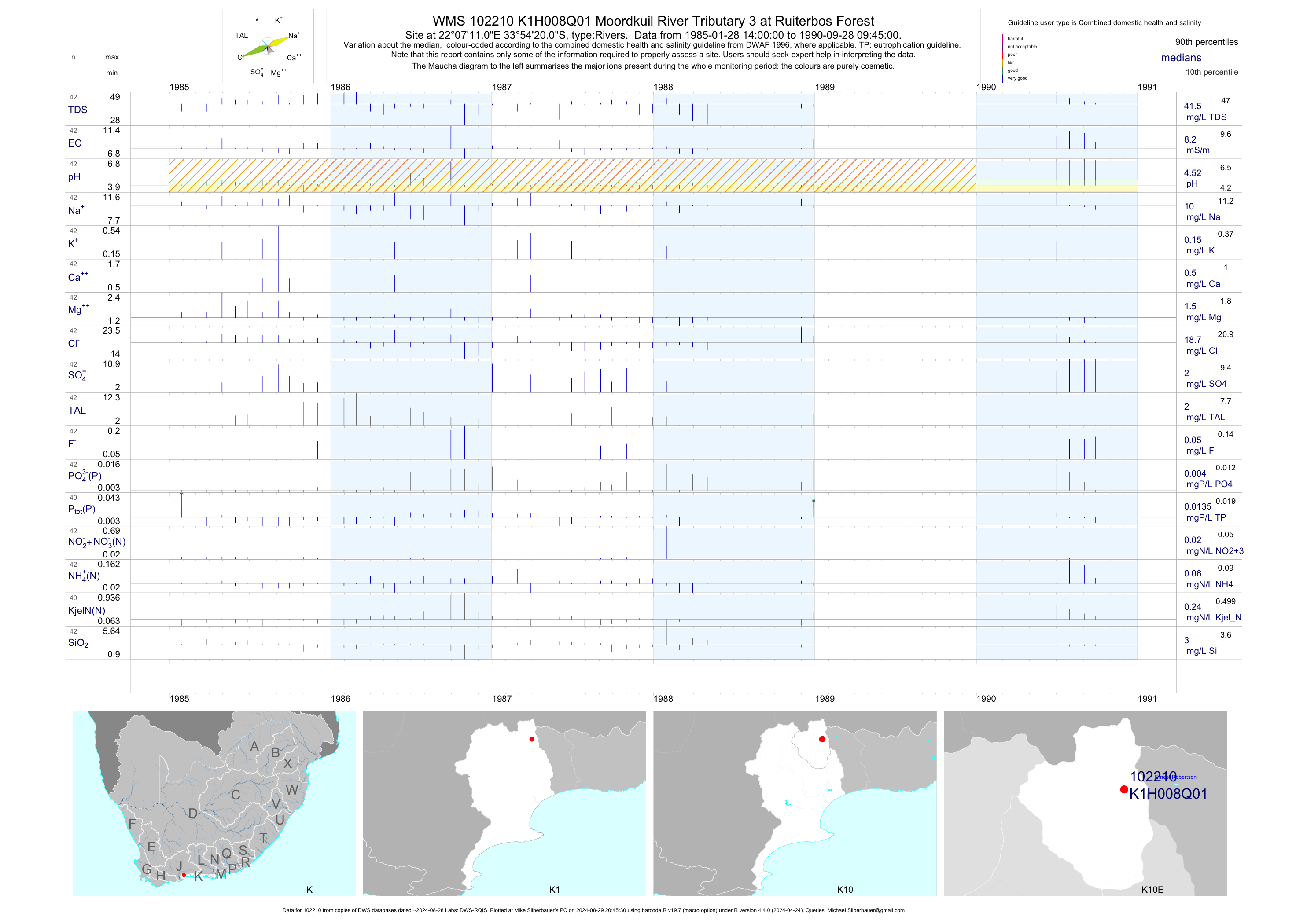
| K10 102210 | plot | data | Moordkuil River Tributary 3 at Ruiterbos Forest | Rivers | 42 | 1985-01-28 | 1990-09-28 | 8 | K1H008 | -33.90556 | 22.11972 |
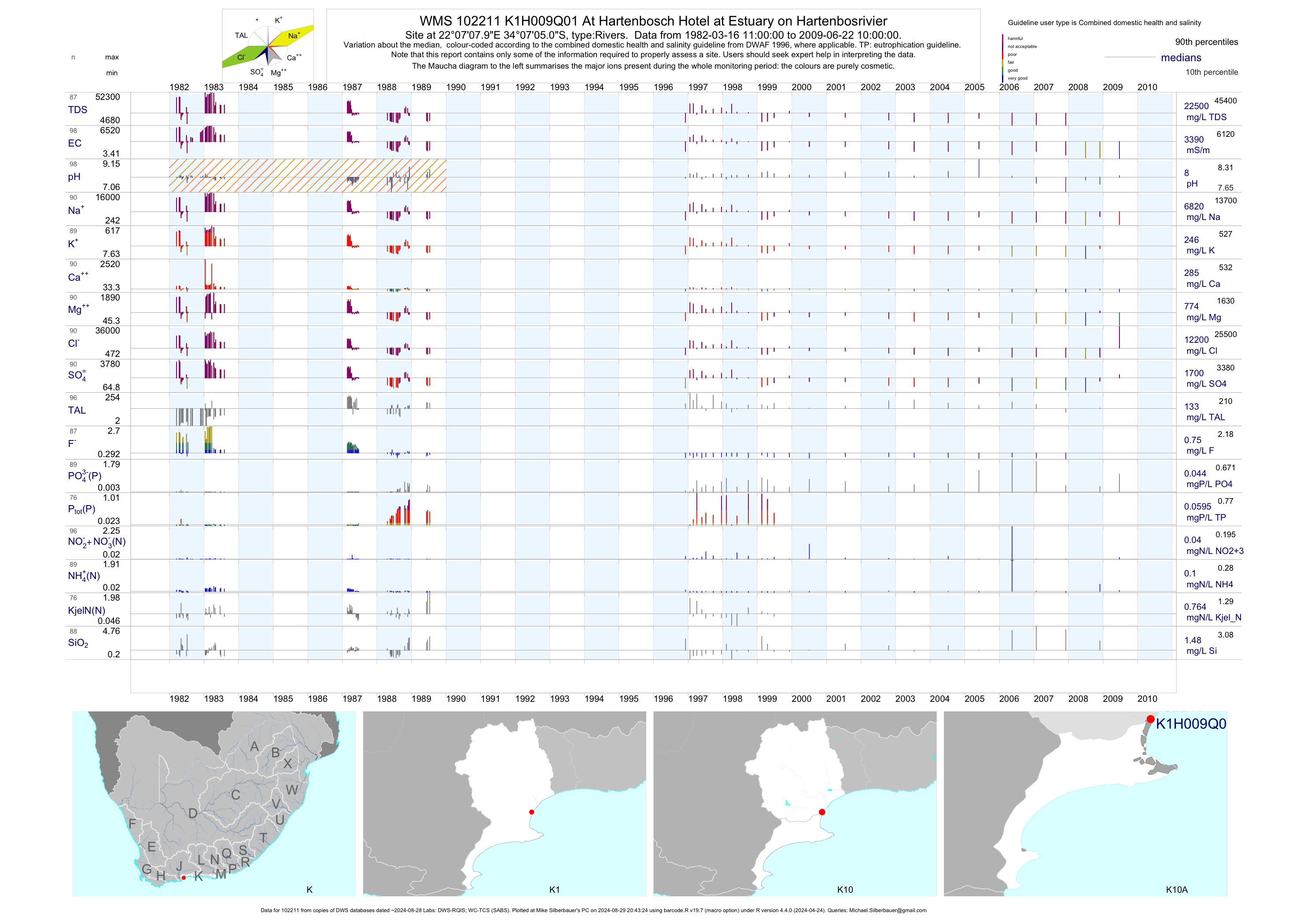
| K10 102211 | plot | data | At Hartenbosch Hotel at Estuary on Hartenbosrivier | Rivers | 98 | 1982-03-16 | 2009-06-22 | 3392 | K1H009 | -34.11806 | 22.11889 |
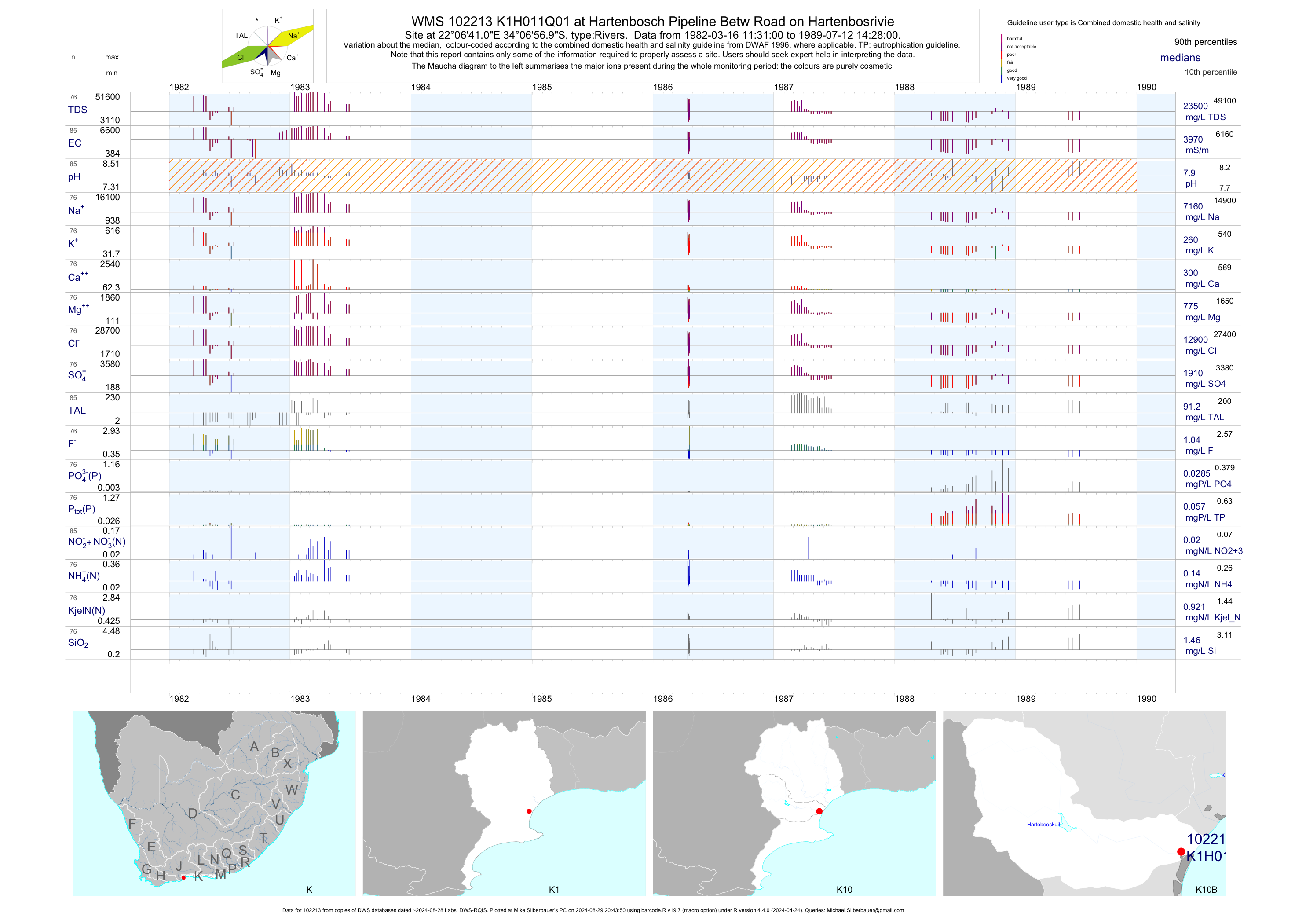
| K10 102213 | plot | data | at Hartenbosch Pipeline Betw Road on Hartenbosrivie | Rivers | 85 | 1982-03-16 | 1989-07-12 | 3968 | K1H011 | -34.11583 | 22.11139 |
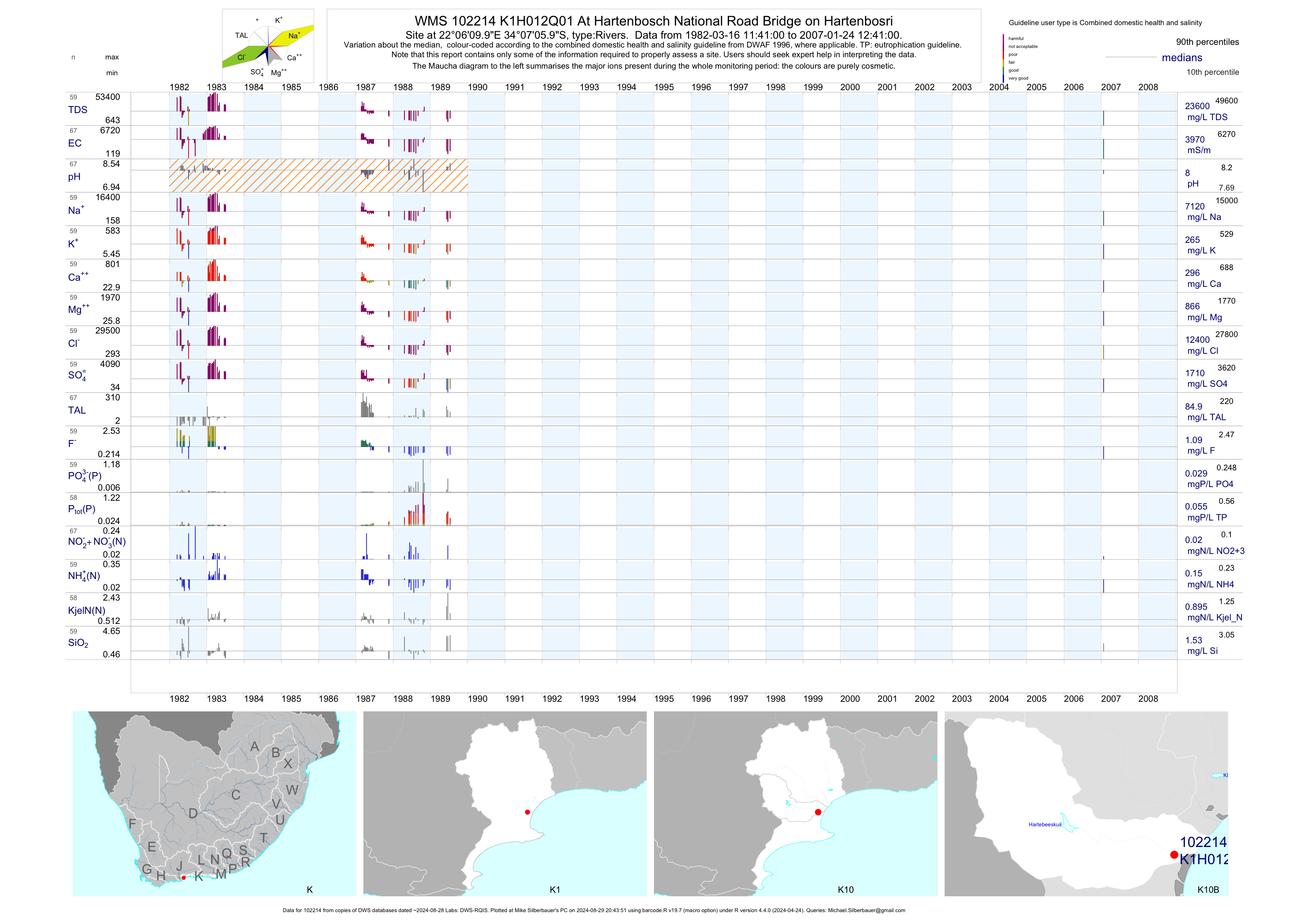
| K10 102214 | plot | data | At Hartenbosch National Road Bridge on Hartenbosri | Rivers | 67 | 1982-03-16 | 2007-01-24 | 3974 | K1H012 | -34.11833 | 22.10278 |
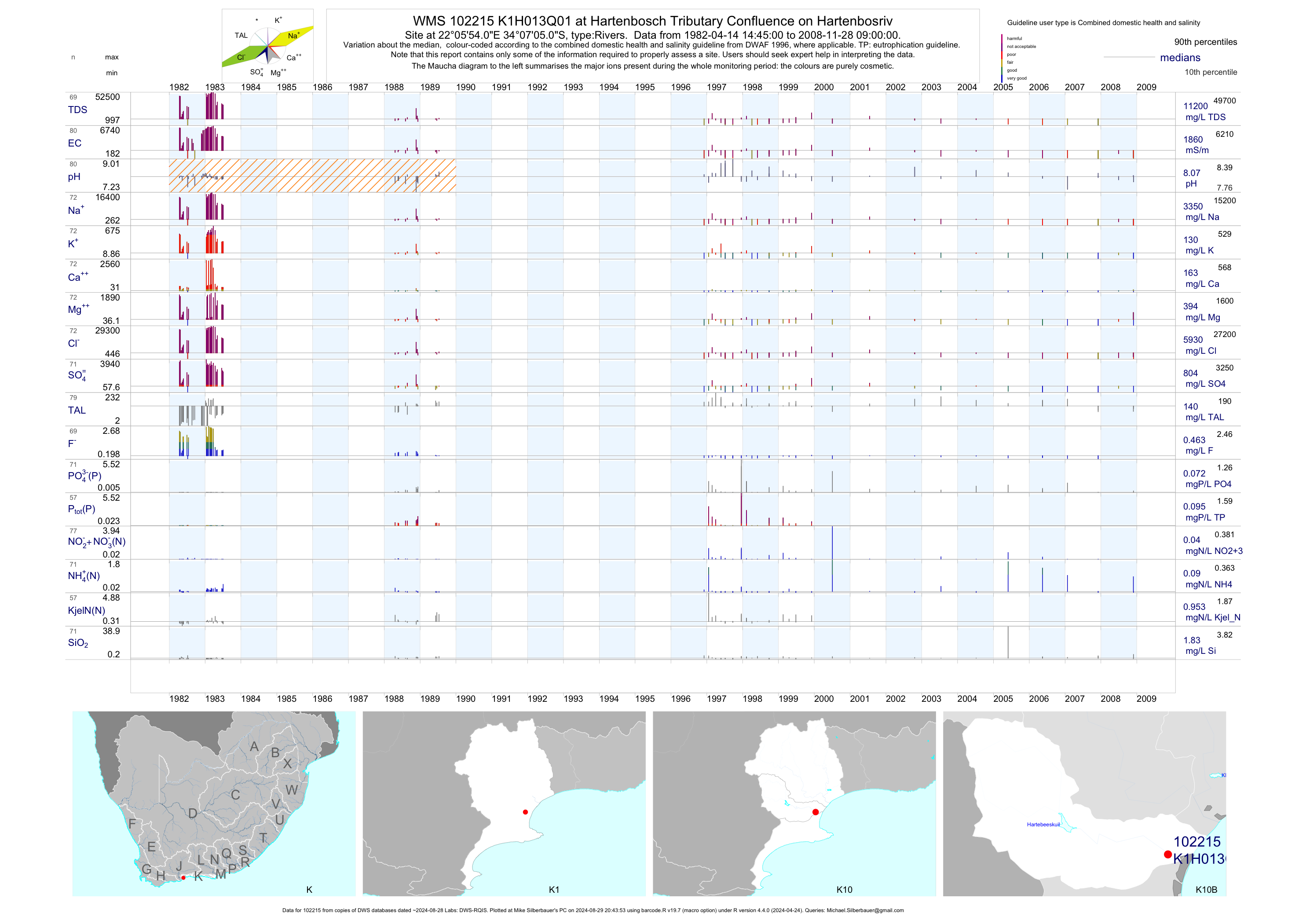
| K10 102215 | plot | data | at Hartenbosch Tributary Confluence on Hartenbosriv | Rivers | 80 | 1982-04-14 | 2008-11-28 | 1858 | K1H013 | -34.11806 | 22.09833 |
| K10 102216 | plot | data | at Hartenbosch Tributary Confluence on Hartenbosriv | Rivers | 15 | 1996-12-04 | 2005-05-30 | 819 | K1H013 | -34.11806 | 22.09833 |
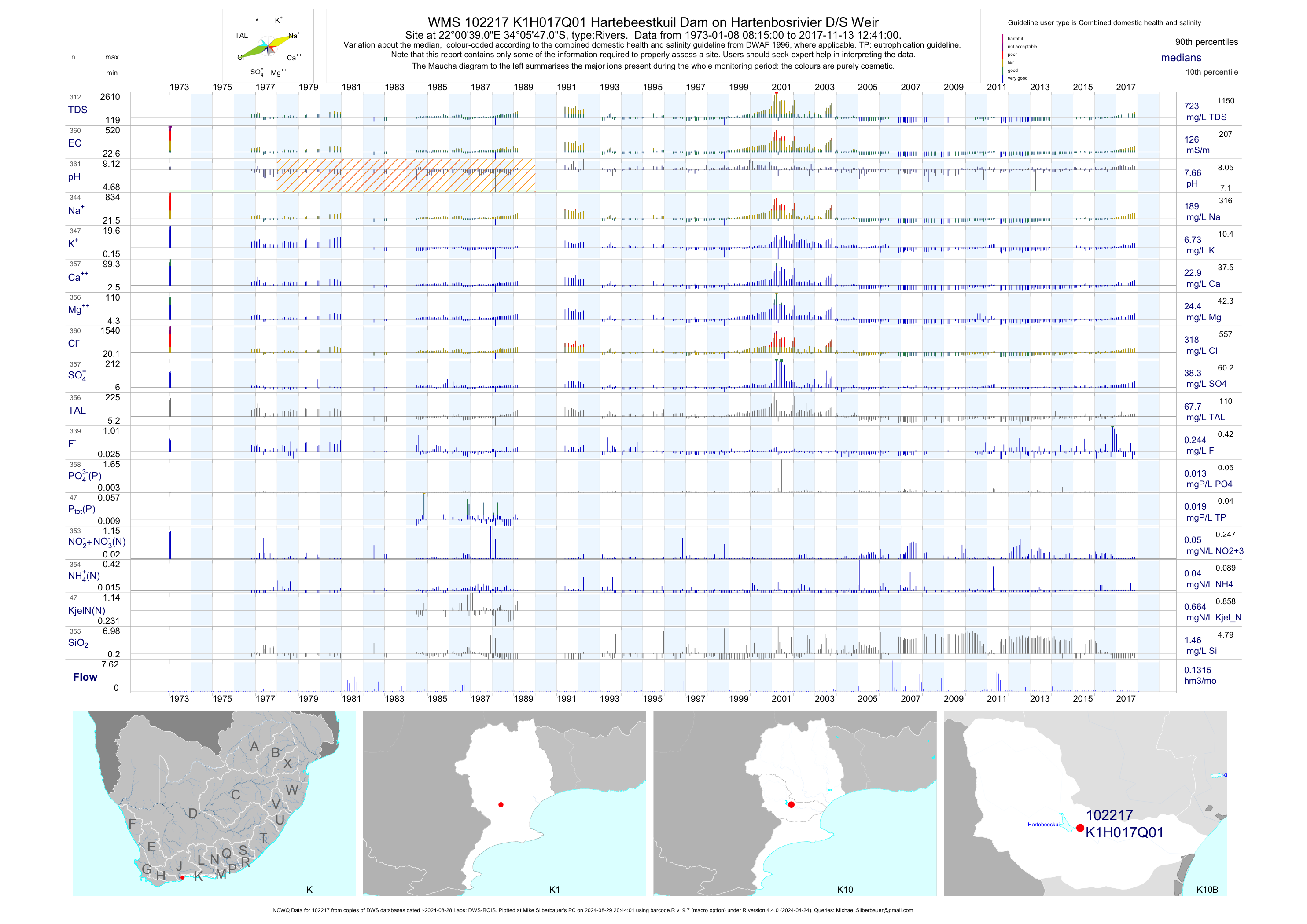
| K10 102217 | plot | data | Hartebeestkuil Dam on Hartenbosrivier D/S Weir (NCWQ) | Rivers | 361 | 1973-01-08 | 2017-11-13 | 126 | K1H017 | -34.09639 | 22.01083 |
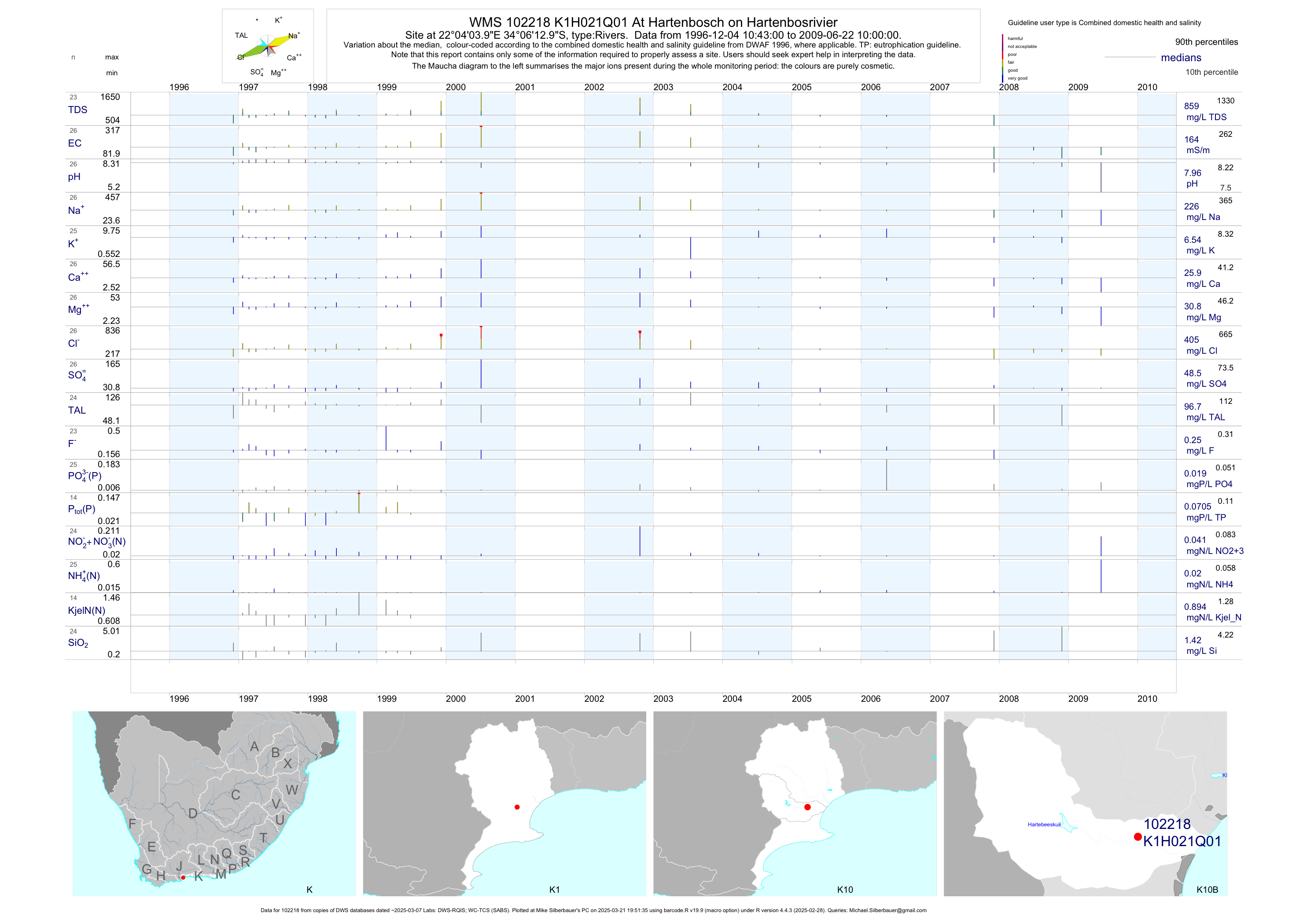
| K10 102218 | plot | data | At Hartenbosch on Hartenbosrivier | Rivers | 28 | 1996-12-04 | 2009-06-22 | 164 | K1H021 | -34.10361 | 22.06778 |
| K10 102220 | plot | data | At Hartenbosch on Hartenbosrivier | Rivers | 28 | 1996-12-04 | 2009-06-22 | 805 | K1H023 | -34.11278 | 22.10278 |
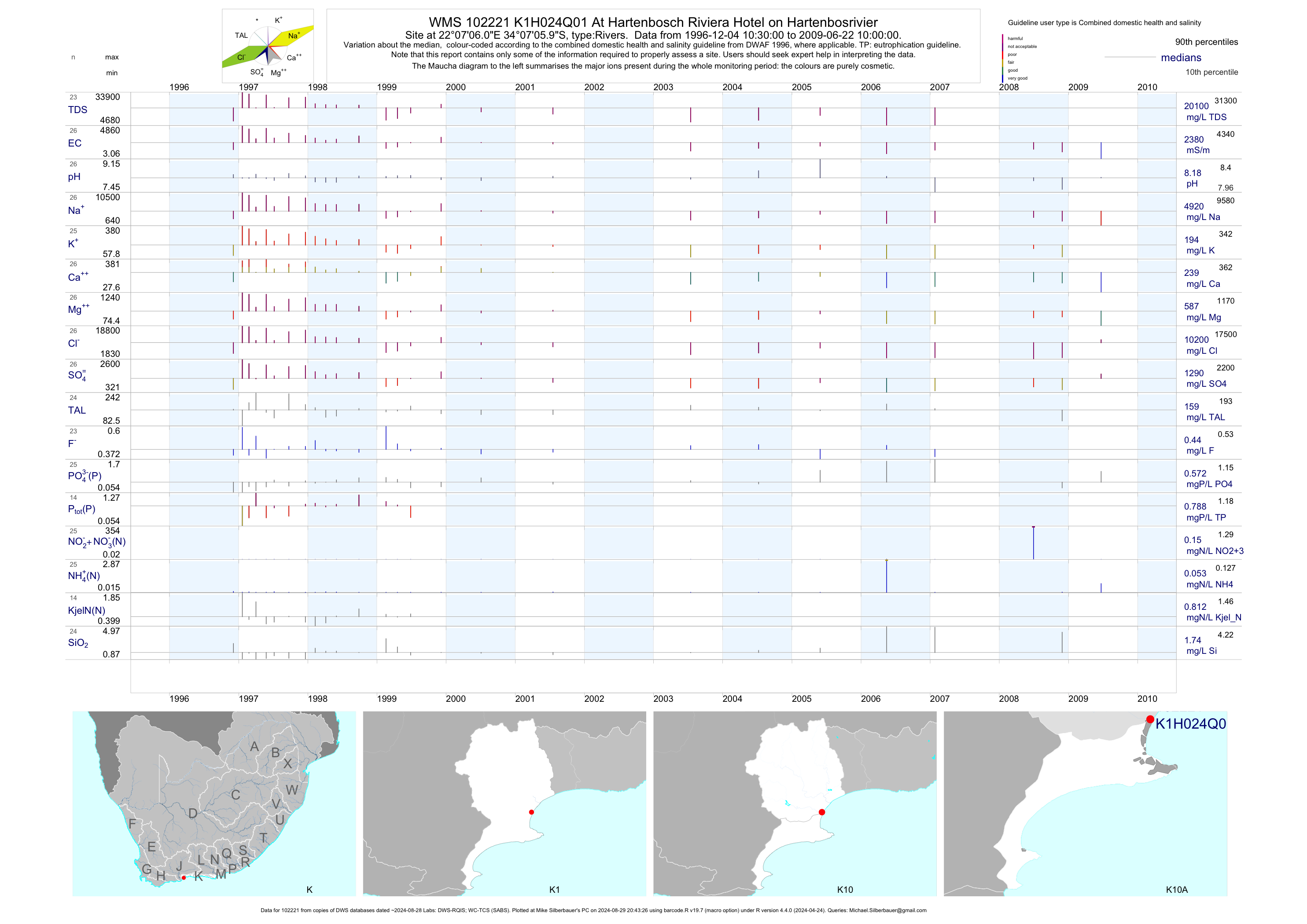
| K10 102221 | plot | data | At Hartenbosch Riviera Hotel on Hartenbosrivier | Rivers | 27 | 1996-12-04 | 2009-06-22 | 2380 | K1H024 | -34.11833 | 22.11833 |
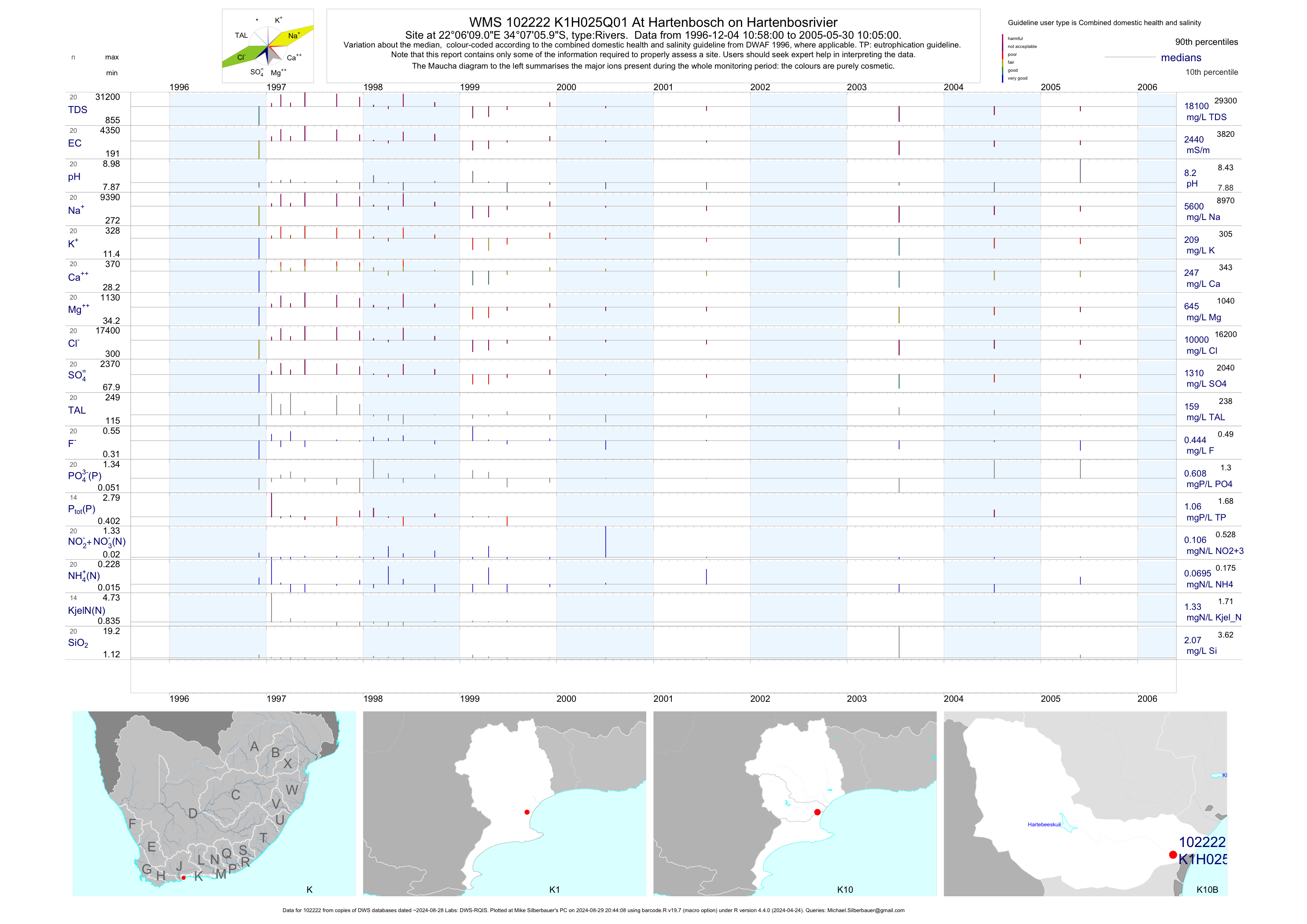
| K10 102222 | plot | data | At Hartenbosch on Hartenbosrivier | Rivers | 21 | 1996-12-04 | 2005-05-30 | 2435 | K1H025 | -34.11833 | 22.10250 |
| K10 197463 | n/a | n/a | - Hartenbos - D/S WWTW on Hartenbosrivier (NMMP) | Rivers | 4 | 2018-01-25 | 2018-06-14 | n/a | MB3 | -34.11823 | 22.10071 |
| K10 197462 | n/a | n/a | - Klein Brak - on Klein Brak River (NMMP) | Rivers | 4 | 2018-01-30 | 2018-06-14 | n/a | MB4 | -34.08098 | 22.13226 |
| K10 102219 | plot | data | - K1H022Q01 Hartenbos at Road Bridge on Hartenbosrivier (NMMP) | Rivers | 24 | 1996-12-04 | 2009-06-22 | 226 | MB7 | -34.11000 | 22.08556 |
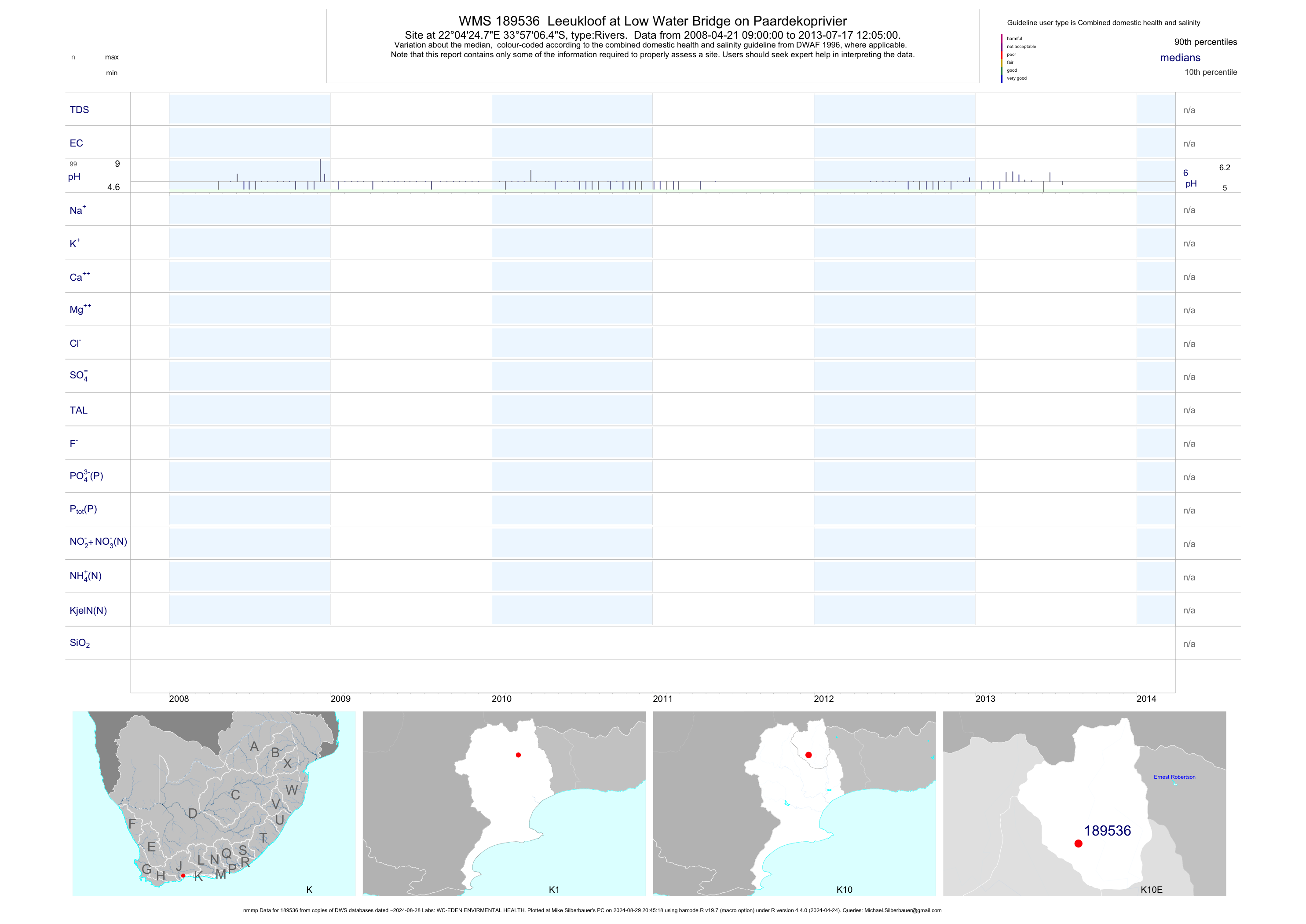
| K10 189536 | plot | data | Leeukloof at Low Water Bridge on Paardekoprivier (nmmp) | Rivers | 233 | 2007-03-05 | 2013-07-17 | n/a | 189536 | -33.95178 | 22.07356 |
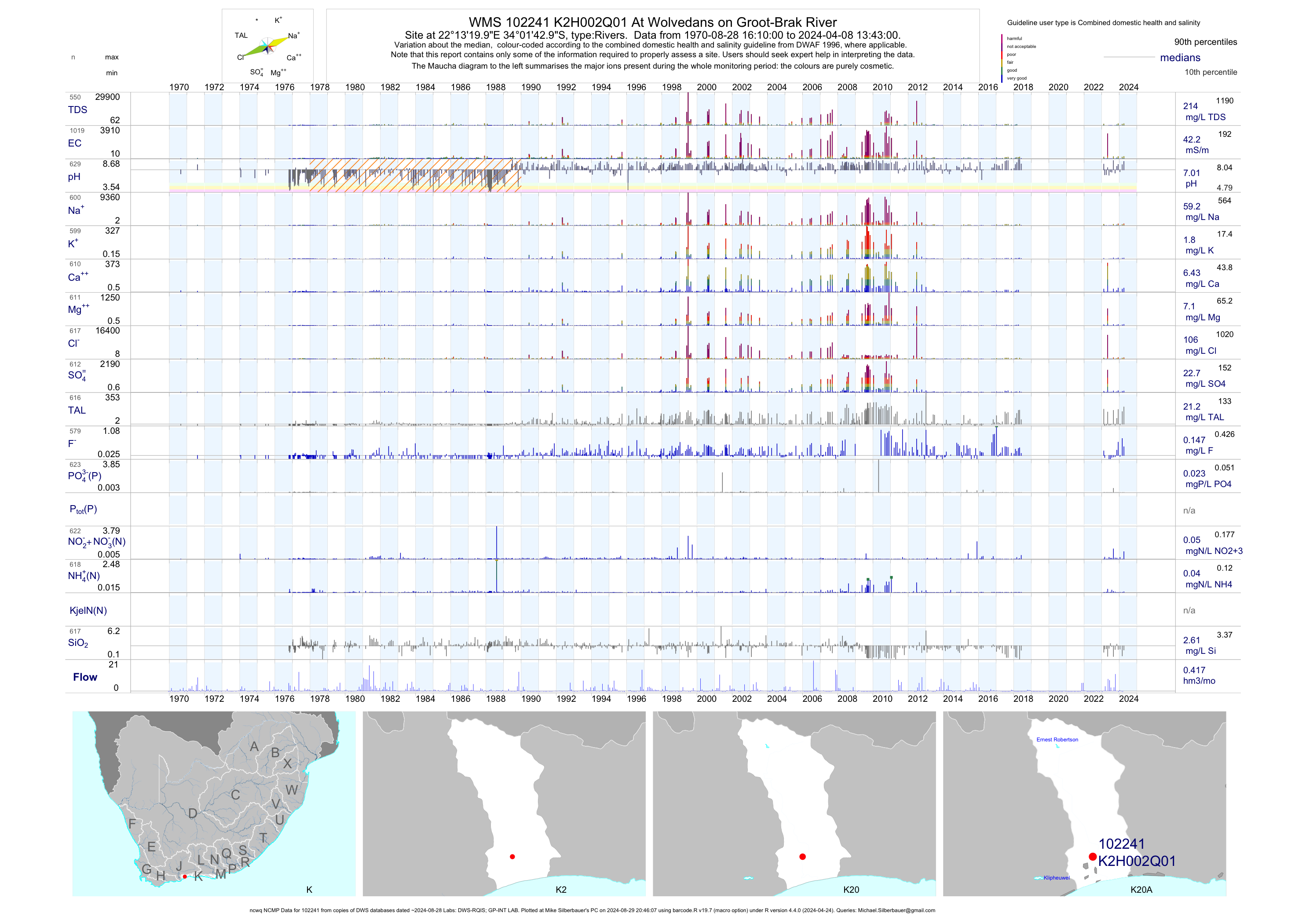
| K20 102241 | plot | data | At Wolvedans on Groot-Brak River (ncwq NCMP) | Rivers | 1008 | 1970-08-28 | 2018-06-07 | 42 | K2H002 | -34.02861 | 22.22222 |
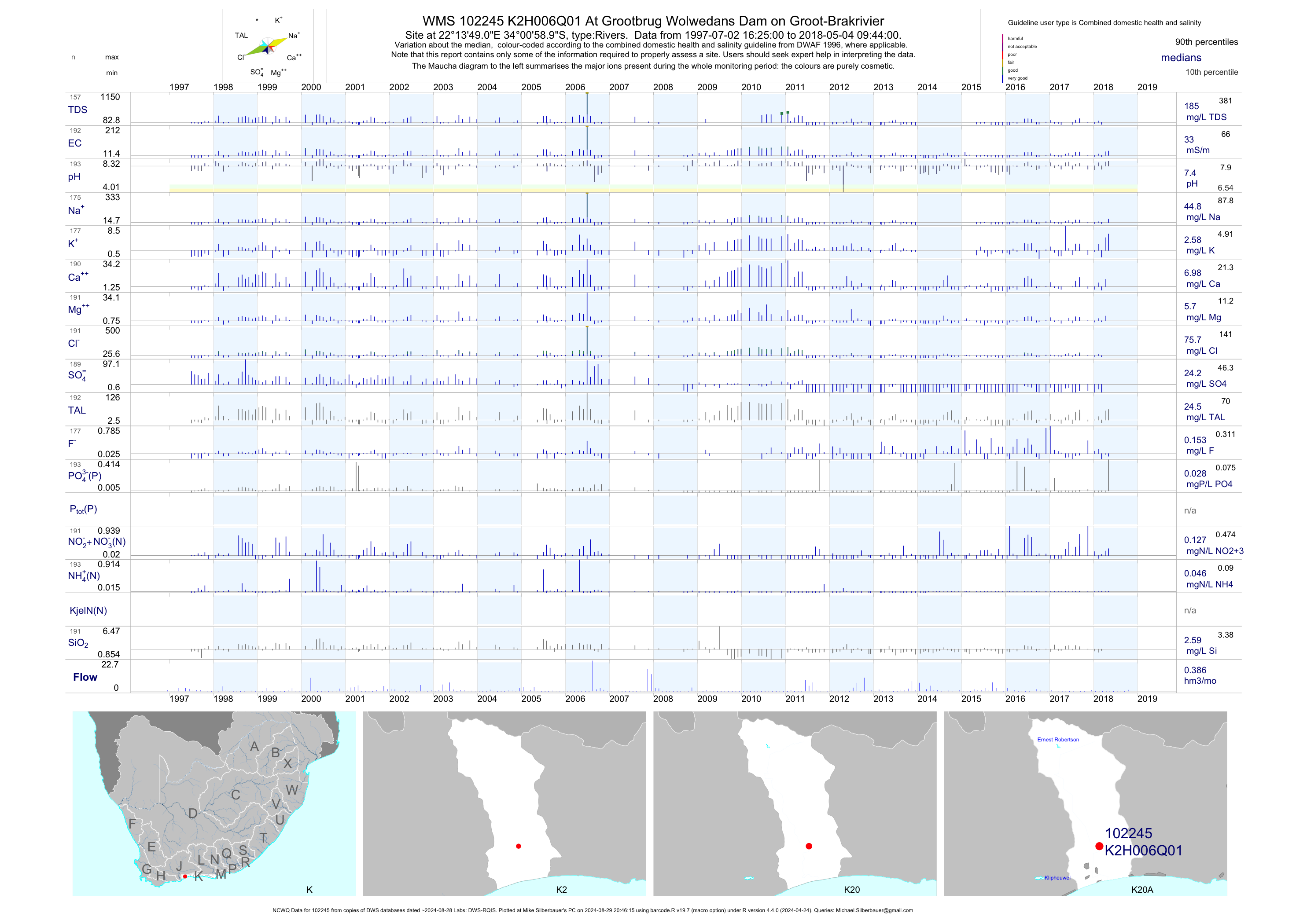
| K20 102245 | plot | data | At Grootbrug Wolwedans Dam on Groot-Brakrivier (NCWQ) | Rivers | 193 | 1997-07-02 | 2018-05-04 | 33 | K2H006 | -34.01639 | 22.23028 |
| K20 87166 | n/a | n/a | - K2H010 Groot Brakrivier Voorburg 255 - on Groot-Brakrivier (NMMP) | Rivers | 4 | 2018-01-25 | 2018-06-14 | n/a | MB5 | -34.03361 | 22.22222 |
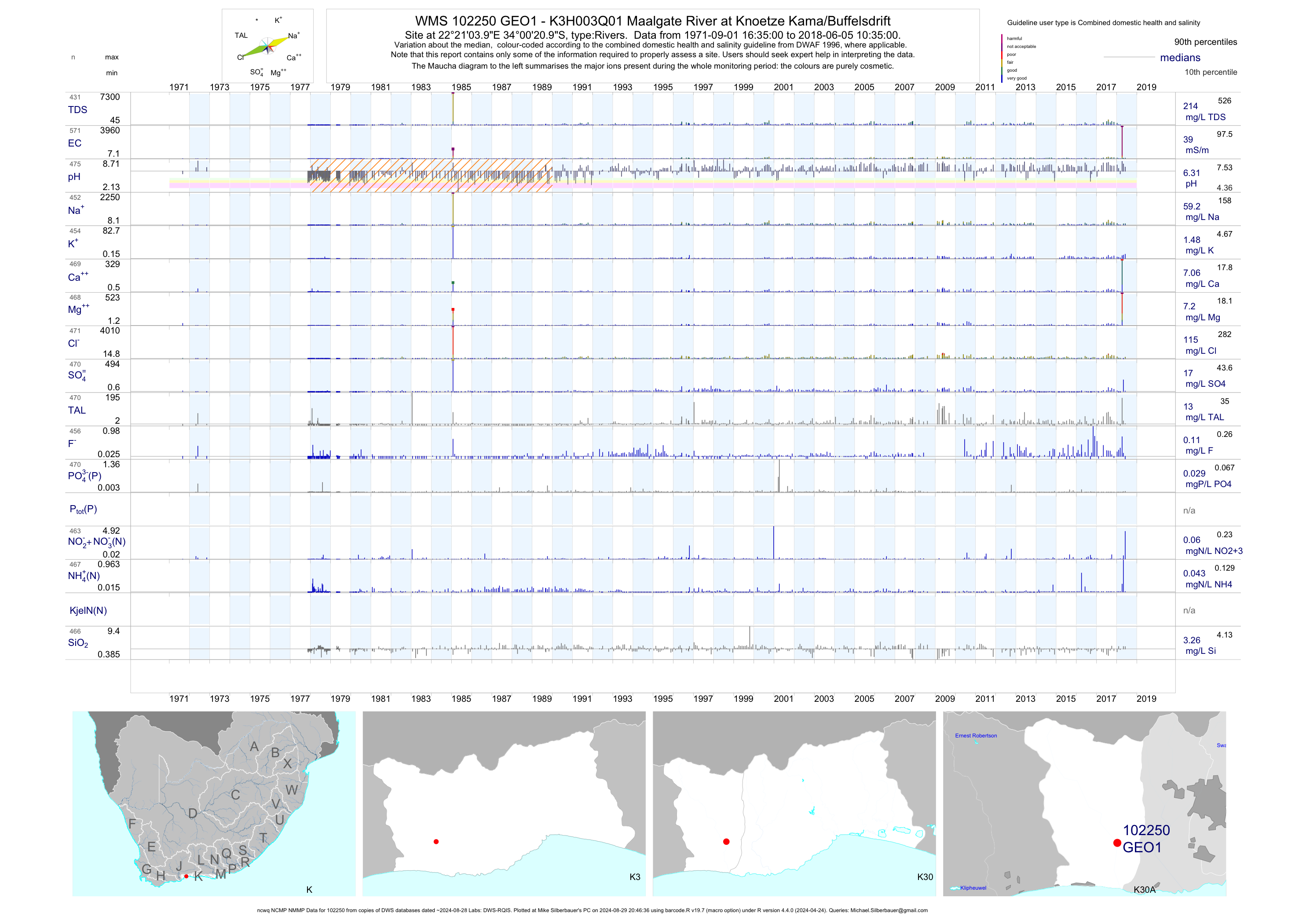
| K30 102250 | plot | data | - K3H003Q01 Maalgate River at Knoetze Kama/Buffelsdrift (ncwq NCMP NMMP) | Rivers | 575 | 1971-09-01 | 2018-06-05 | 39 | GEO1 | -34.00583 | 22.35111 |
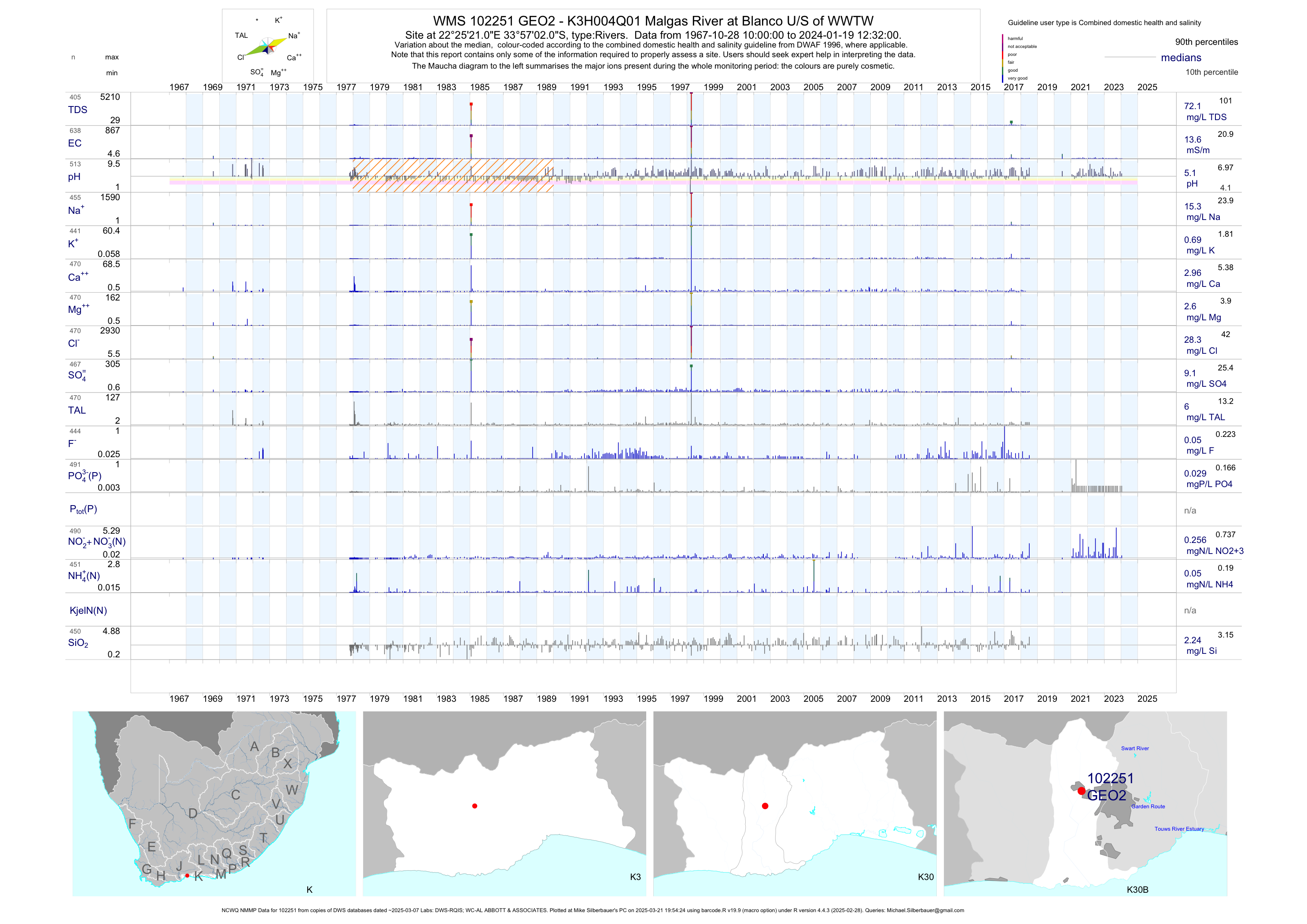
| K30 102251 | plot | data | - K3H004Q01 Malgas River at Blanco U/S of WWTW (NCWQ NMMP) | Rivers | 607 | 1967-10-28 | 2018-07-06 | 14 | GEO2 | -33.95056 | 22.42250 |
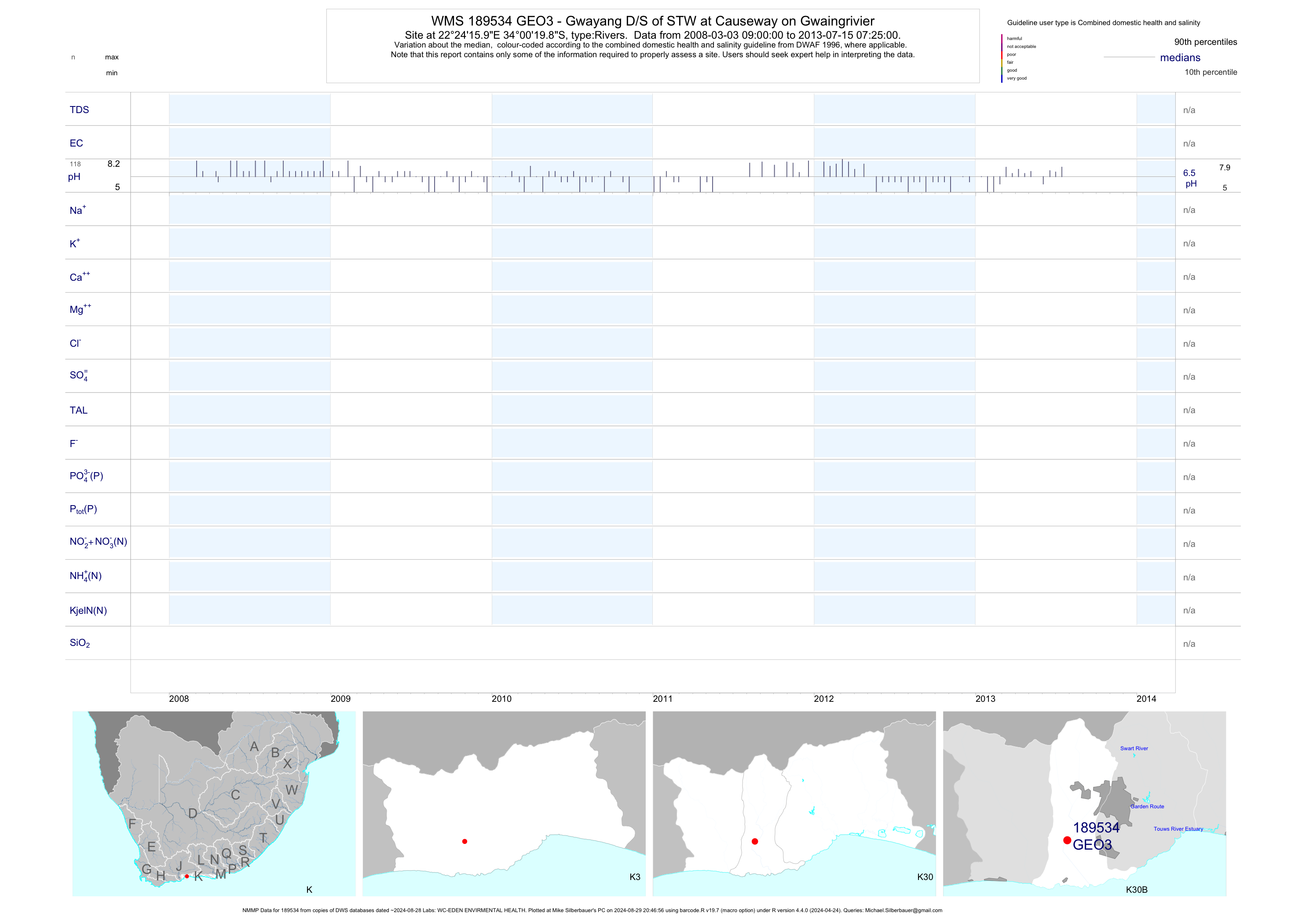
| K30 189534 | plot | data | - Gwayang D/S of STW at Causeway on Gwaingrivier (NMMP) | Rivers | 261 | 2007-03-12 | 2018-05-23 | n/a | GEO3 | -34.00550 | 22.40443 |
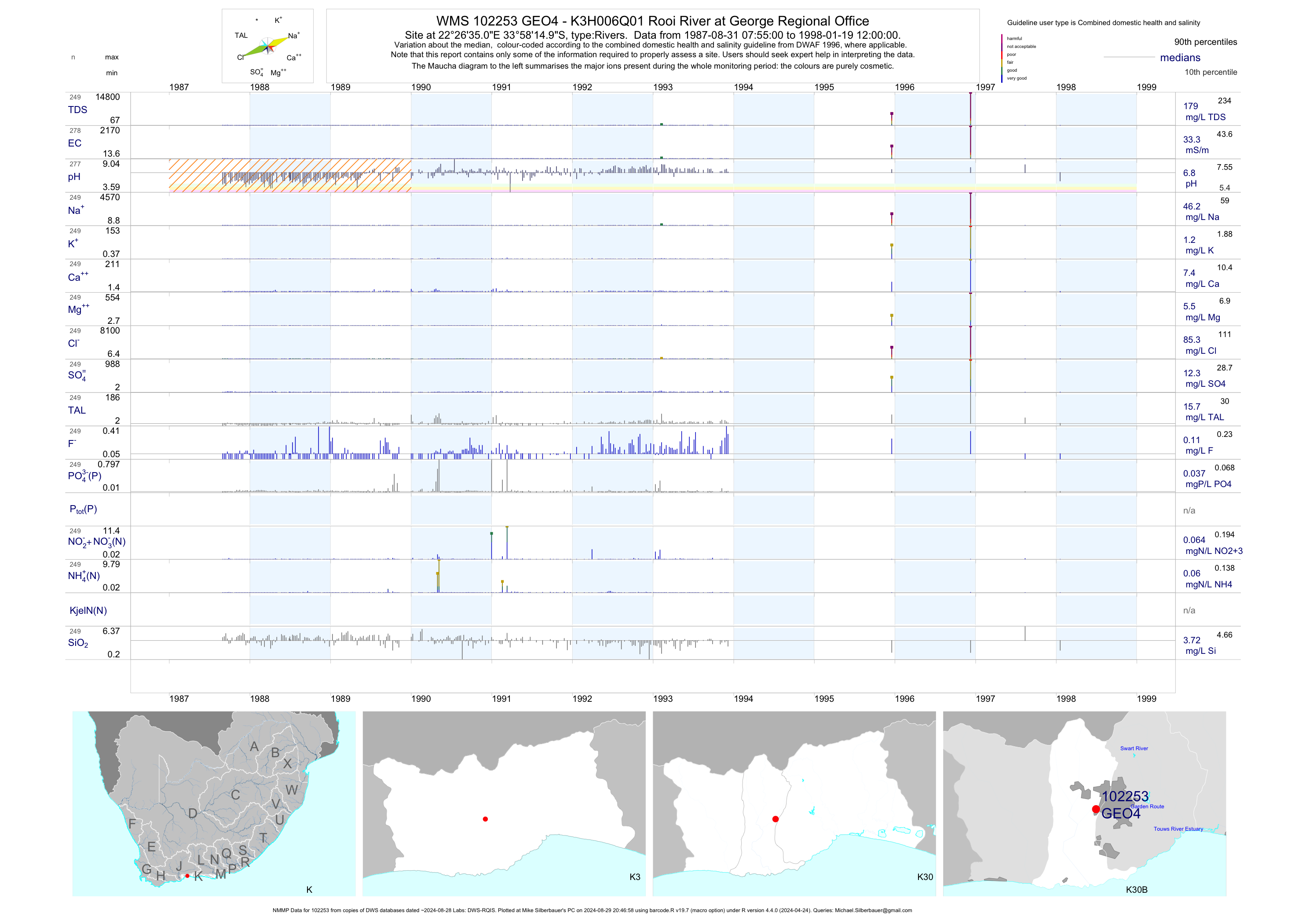
| K30 102253 | plot | data | - K3H006Q01 Rooi River at George Regional Office (NMMP) | Rivers | 280 | 1987-08-31 | 1998-01-19 | 33 | GEO4 | -33.97083 | 22.44306 |
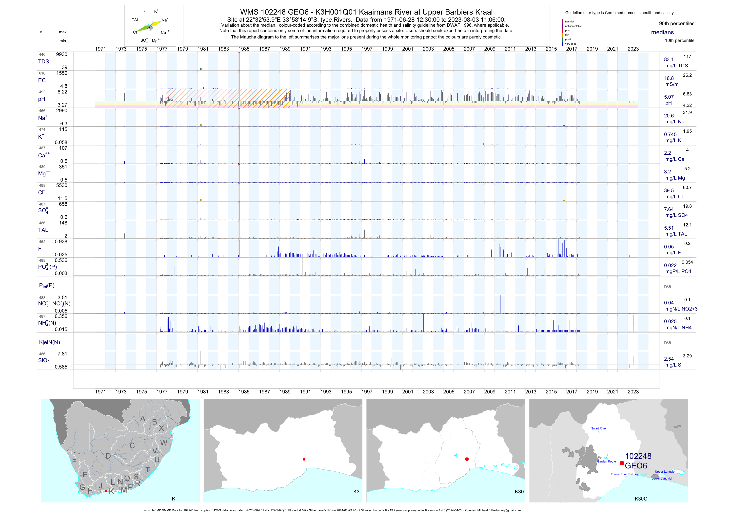
| K30 102248 | plot | data | - K3H001Q01 Kaaimans River at Upper Barbiers Kraal (ncwq NCMP NMMP) | Rivers | 620 | 1971-06-28 | 2018-06-20 | 17 | GEO6 | -33.97083 | 22.54833 |
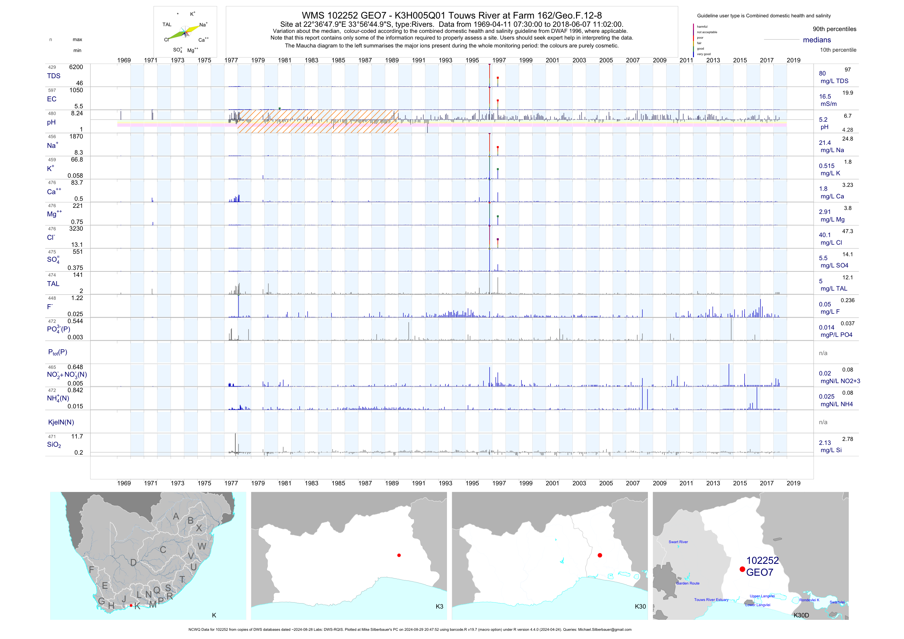
| K30 102252 | plot | data | - K3H005Q01 Touws River at Farm 162/Geo.F.12-8 (NCWQ) | Rivers | 598 | 1969-04-11 | 2018-06-07 | 16 | GEO7 | -33.94583 | 22.61333 |
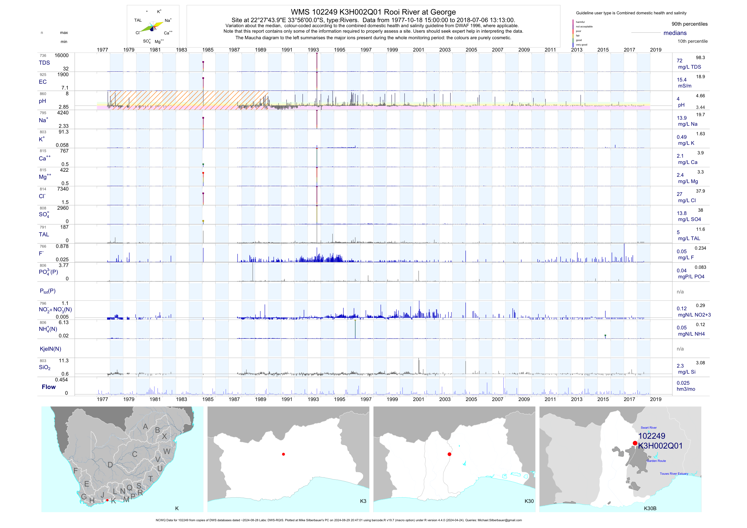
| K30 102249 | plot | data | Rooi River at George (NCWQ) | Rivers | 935 | 1977-10-18 | 2018-07-06 | 15 | K3H002 | -33.93333 | 22.46222 |
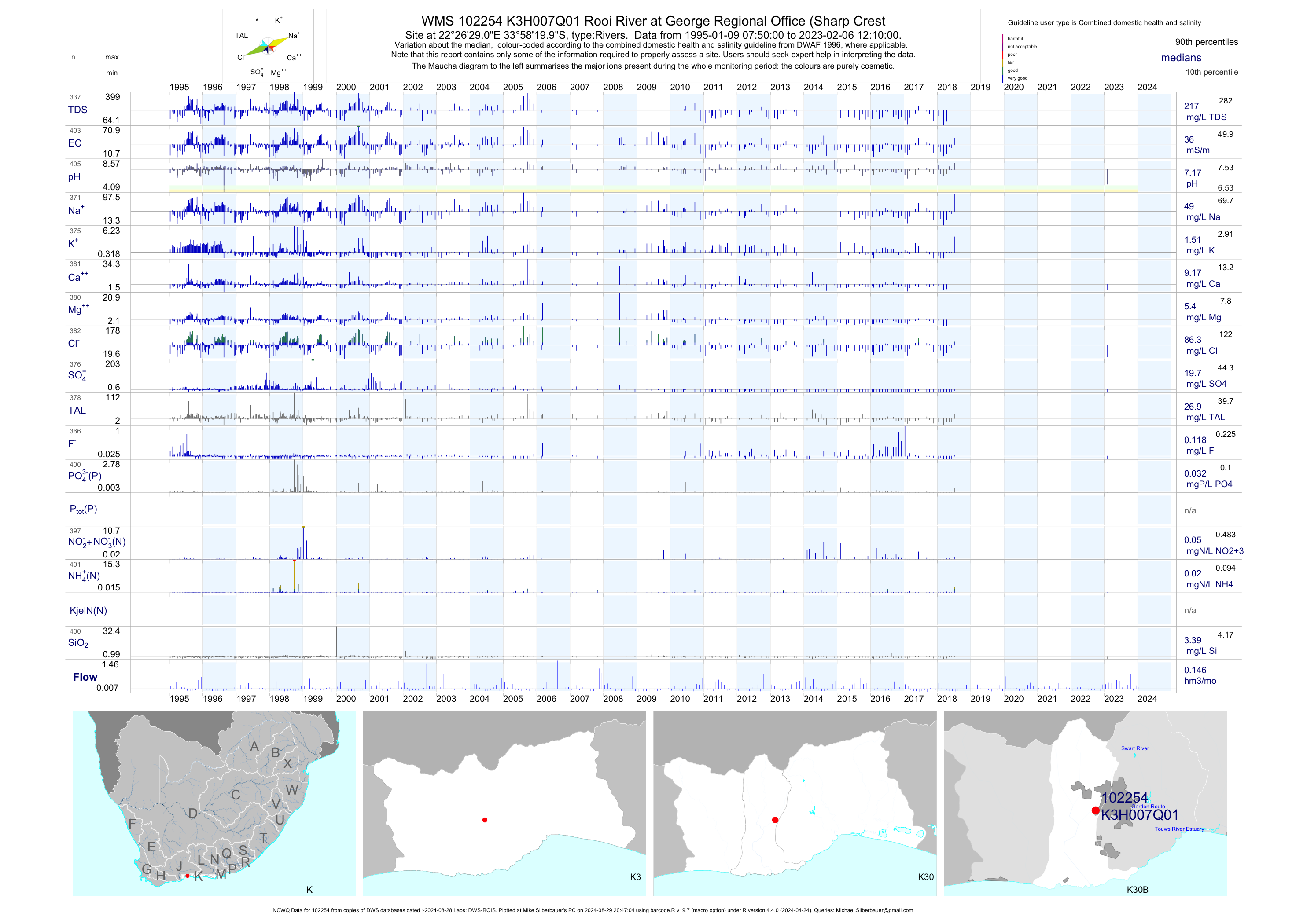
| K30 102254 | plot | data | Rooi River at George Regional Office (Sharp Crest (NCWQ) | Rivers | 404 | 1995-01-09 | 2018-07-06 | 36 | K3H007 | -33.97222 | 22.44139 |
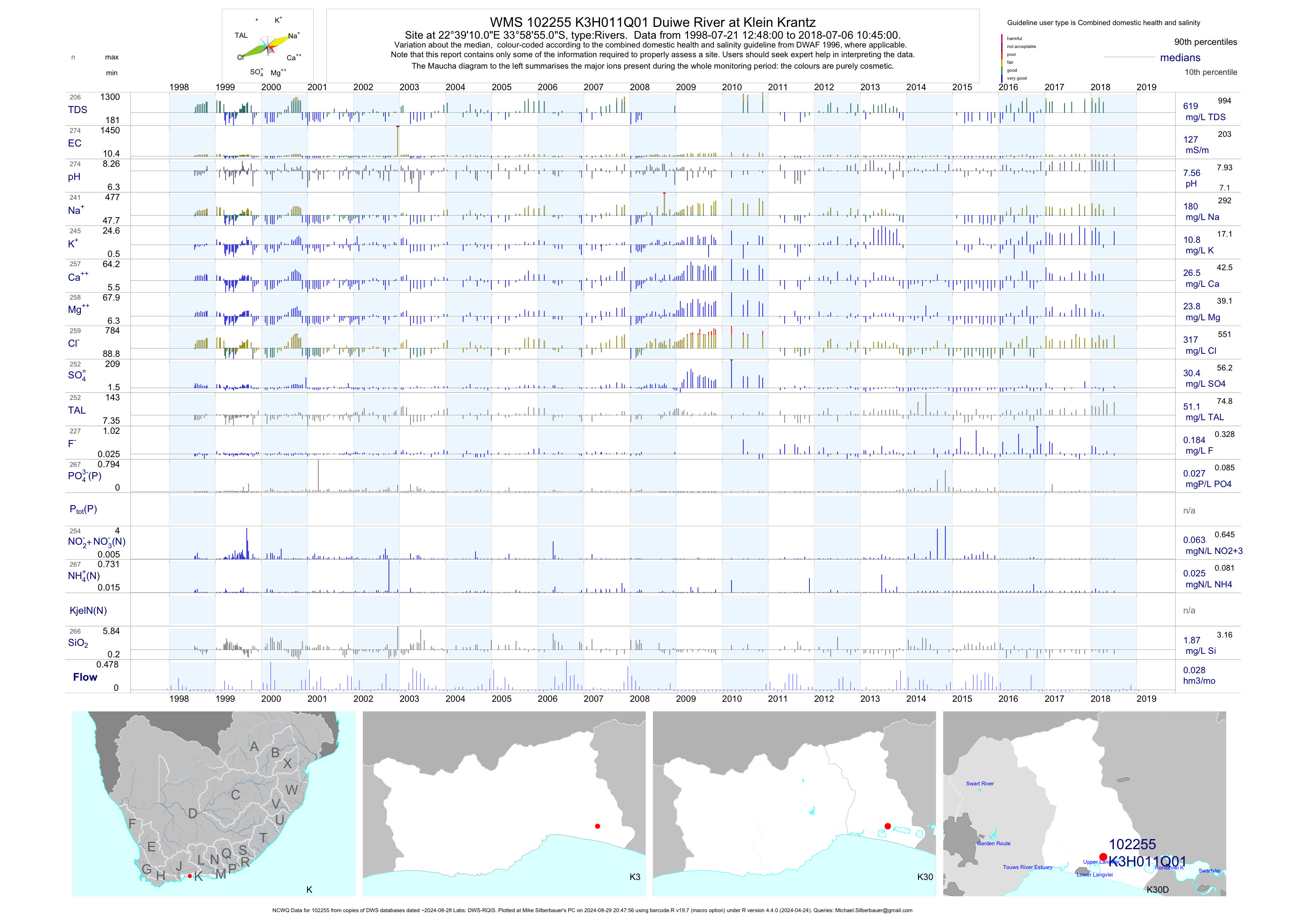
| K30 102255 | plot | data | Duiwe River at Klein Krantz (NCWQ) | Rivers | 275 | 1998-07-21 | 2018-07-06 | 127 | K3H011 | -33.98194 | 22.65278 |
| K30 102256 | plot | data | Touws River at Olifantshoek/Olifantshoogte | Rivers | 23 | 1998-02-05 | 1999-01-15 | 616 | K3H012 | -33.98194 | 22.61194 |
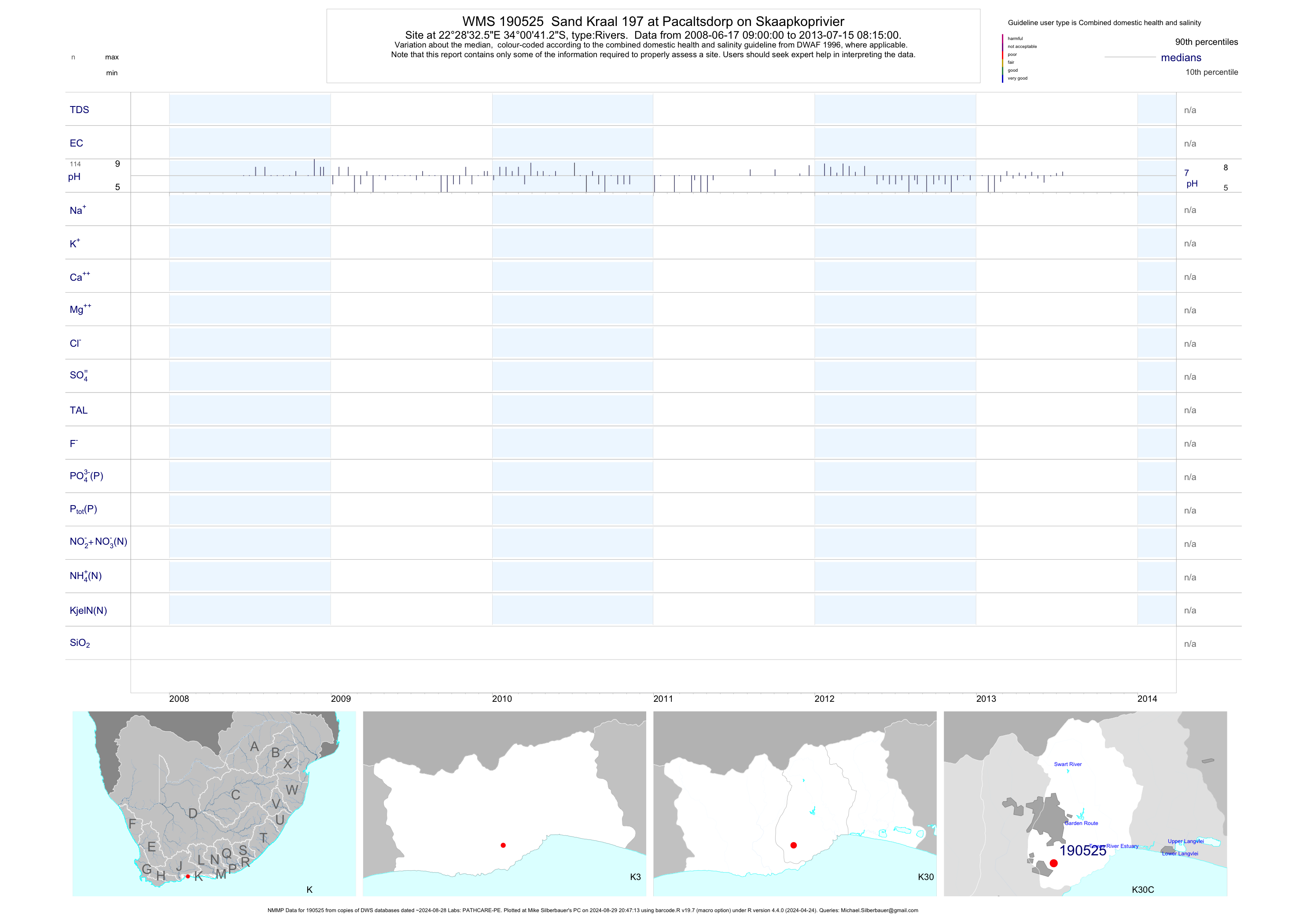
| K30 190525 | plot | data | Sand Kraal 197 at Pacaltsdorp on Skaapkoprivier (NMMP) | Rivers | 124 | 2008-06-17 | 2013-07-15 | n/a | 190525 | -34.01147 | 22.47569 |
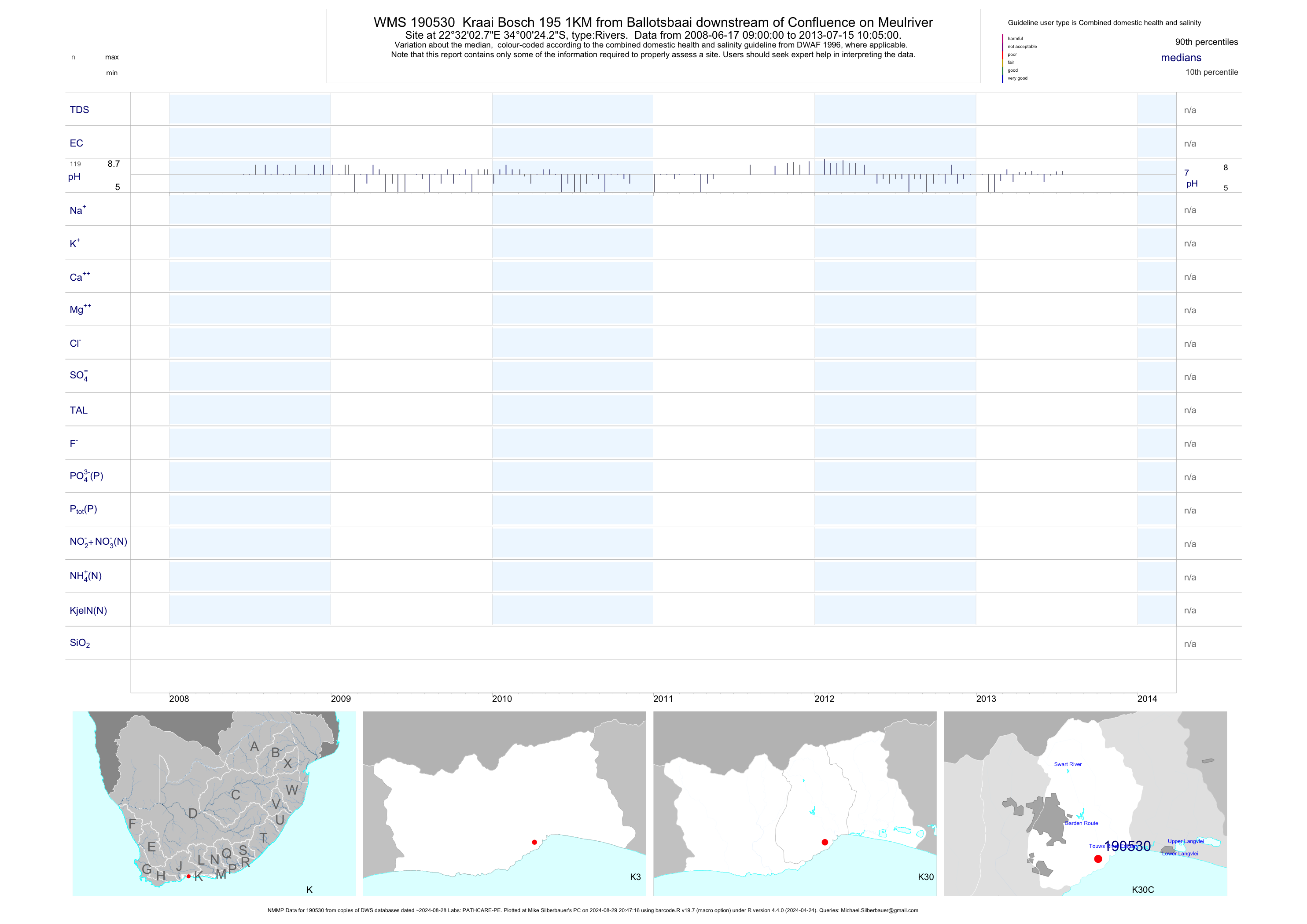
| K30 190530 | plot | data | Kraai Bosch 195 1KM from Ballotsbaai downstream of Confluence on Meulriver (NMMP) | Rivers | 127 | 2008-06-17 | 2013-07-15 | n/a | 190530 | -34.00675 | 22.53411 |
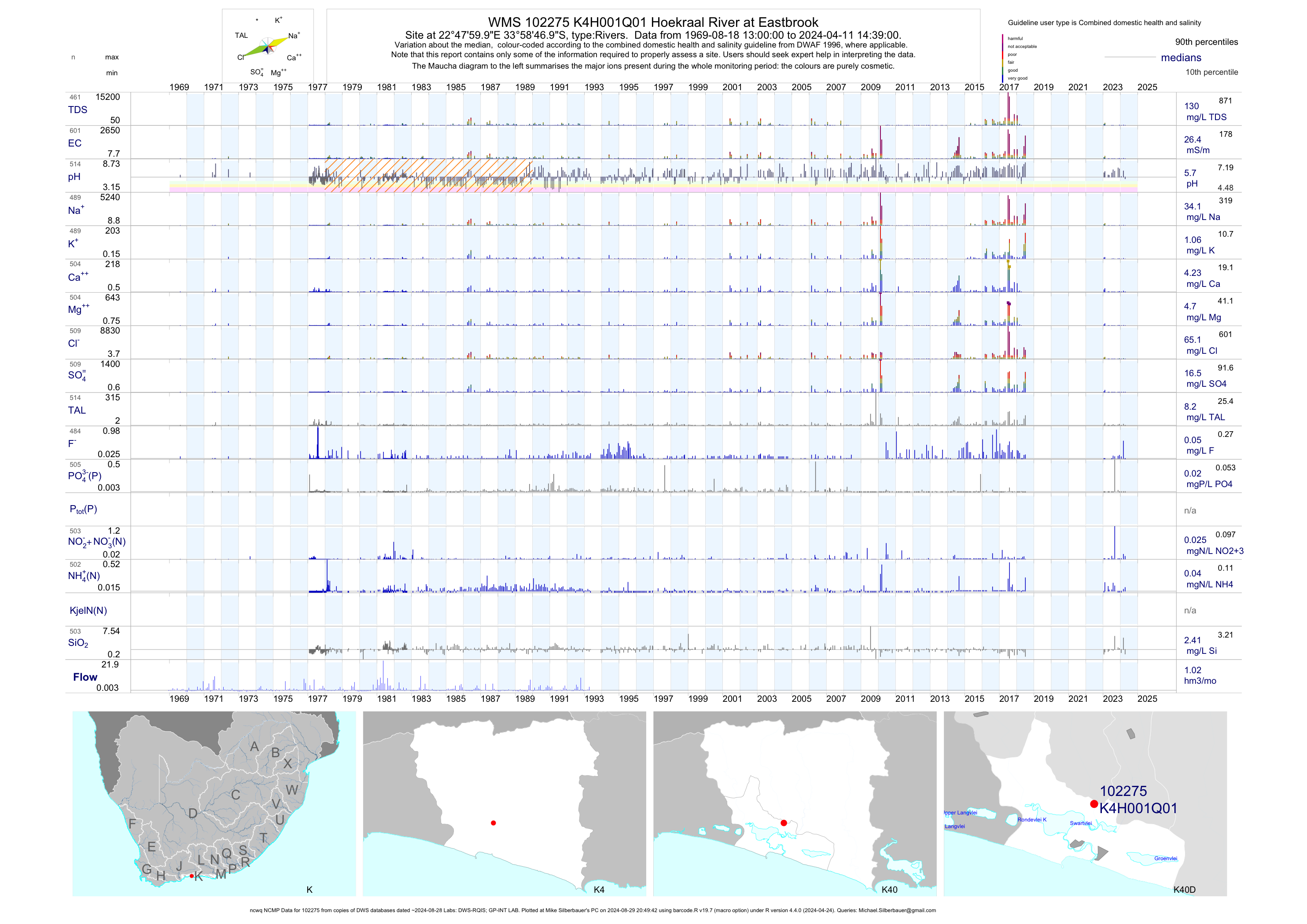
| K40 102275 | plot | data | Hoekraal River at Eastbrook (ncwq NCMP) | Rivers | 591 | 1969-08-18 | 2018-07-05 | 26 | K4H001 | -33.97972 | 22.80000 |
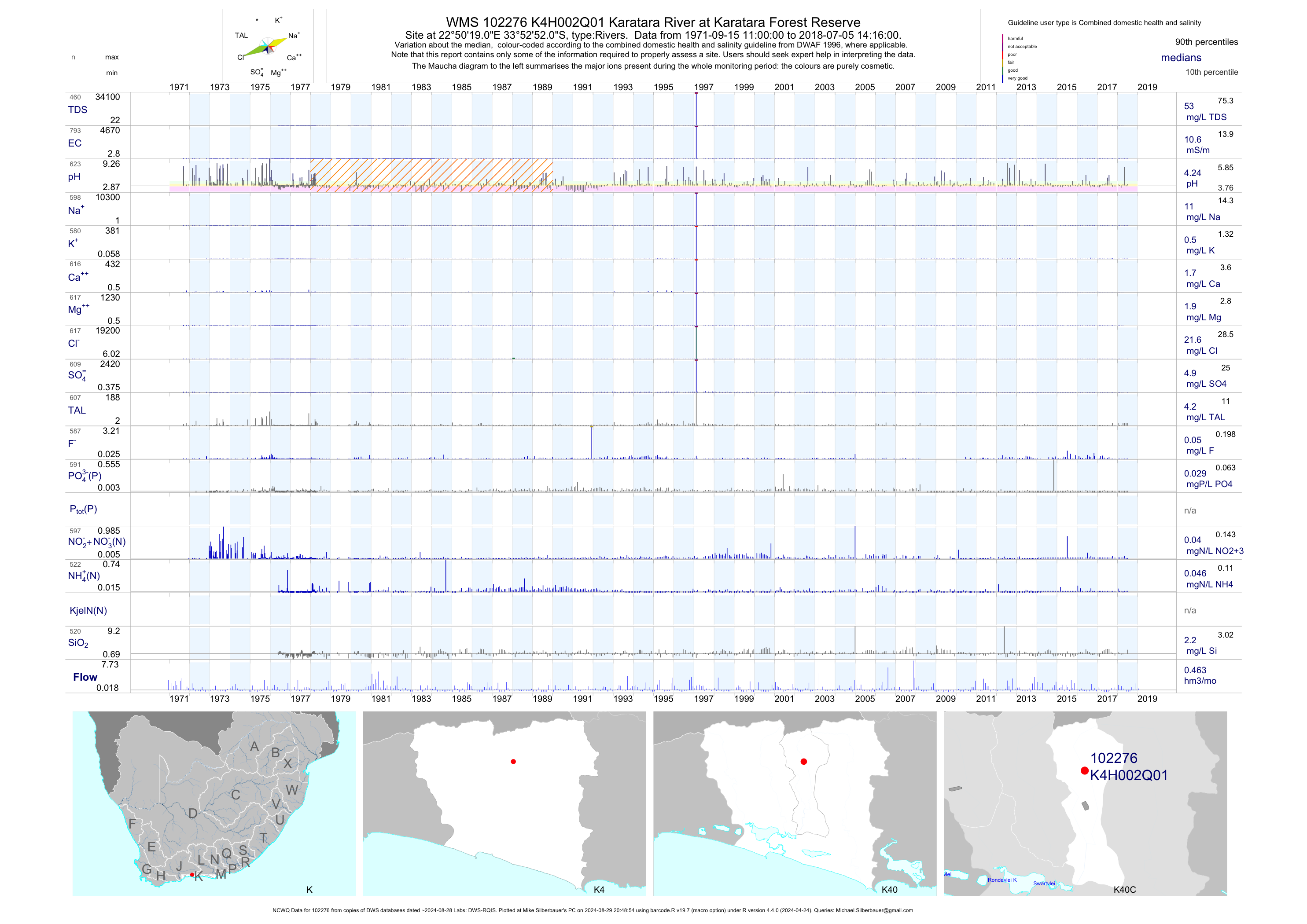
| K40 102276 | plot | data | Karatara River at Karatara Forest Reserve (NCWQ) | Rivers | 799 | 1971-09-15 | 2018-07-05 | 11 | K4H002 | -33.88111 | 22.83861 |
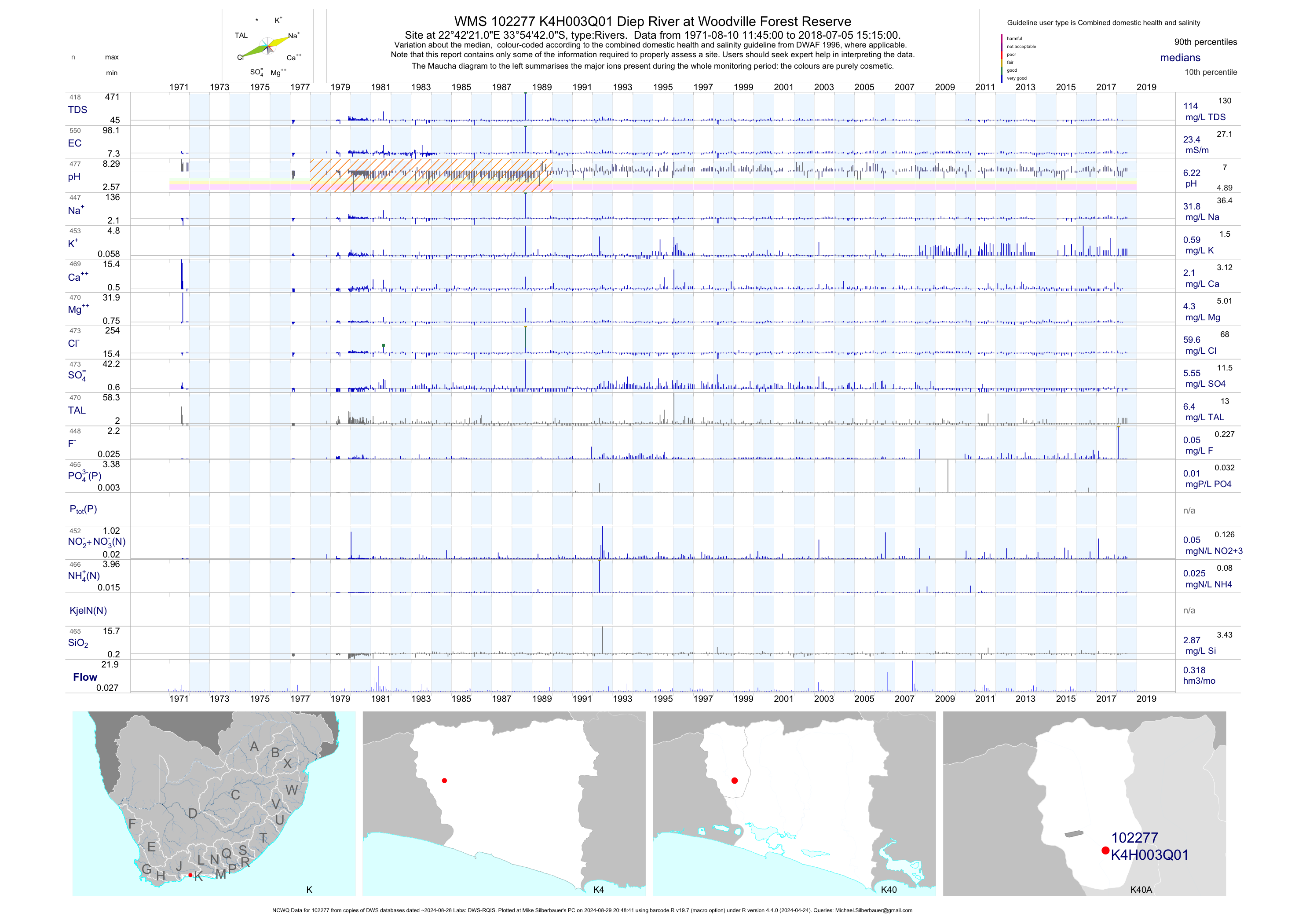
| K40 102277 | plot | data | Diep River at Woodville Forest Reserve (NCWQ) | Rivers | 550 | 1971-08-10 | 2018-07-05 | 23 | K4H003 | -33.91167 | 22.70583 |
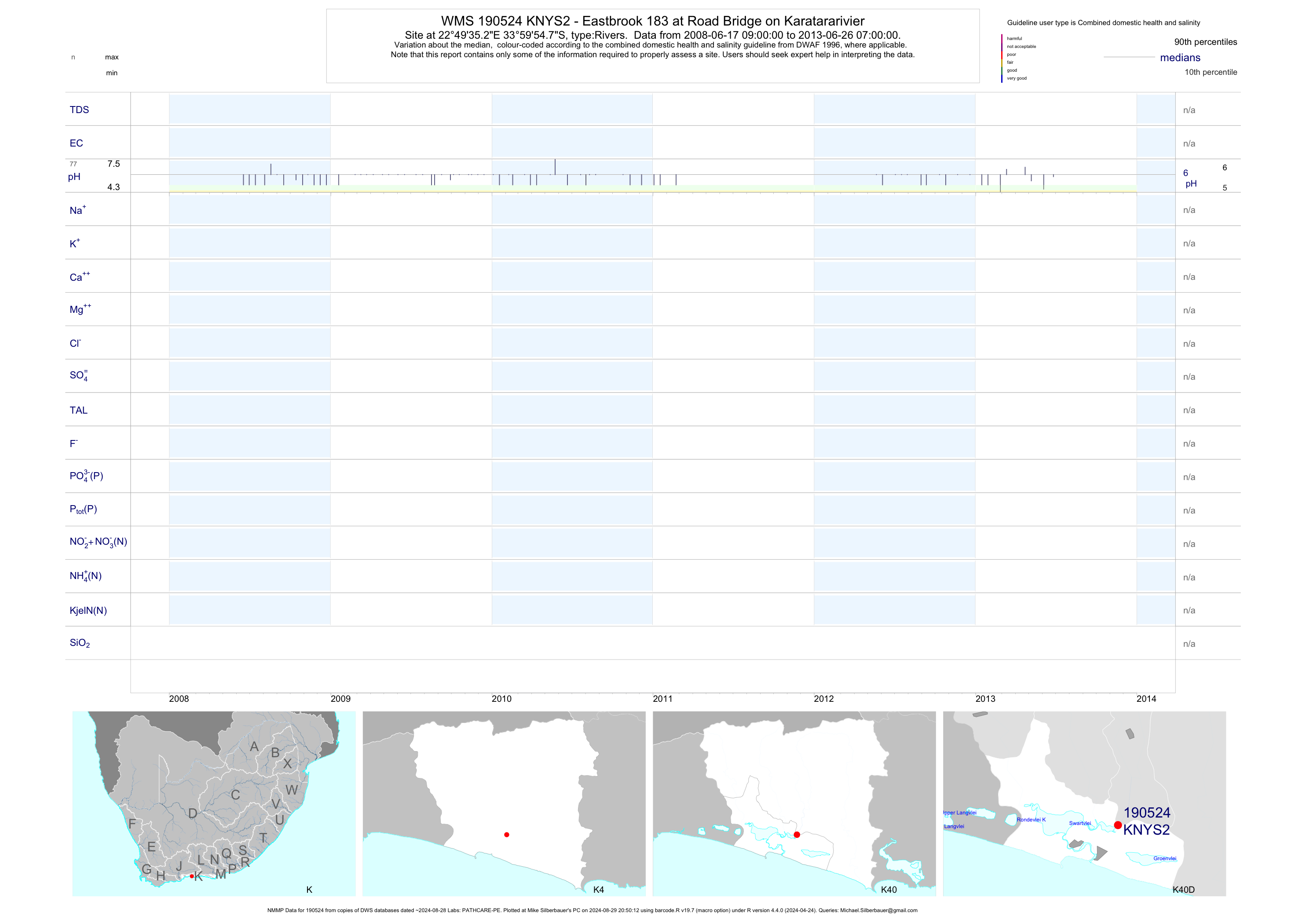
| K40 190524 | plot | data | - Eastbrook 183 at Road Bridge on Karatararivier (NMMP) | Rivers | 87 | 2008-06-17 | 2013-06-26 | n/a | KNYS2 | -33.99856 | 22.82647 |
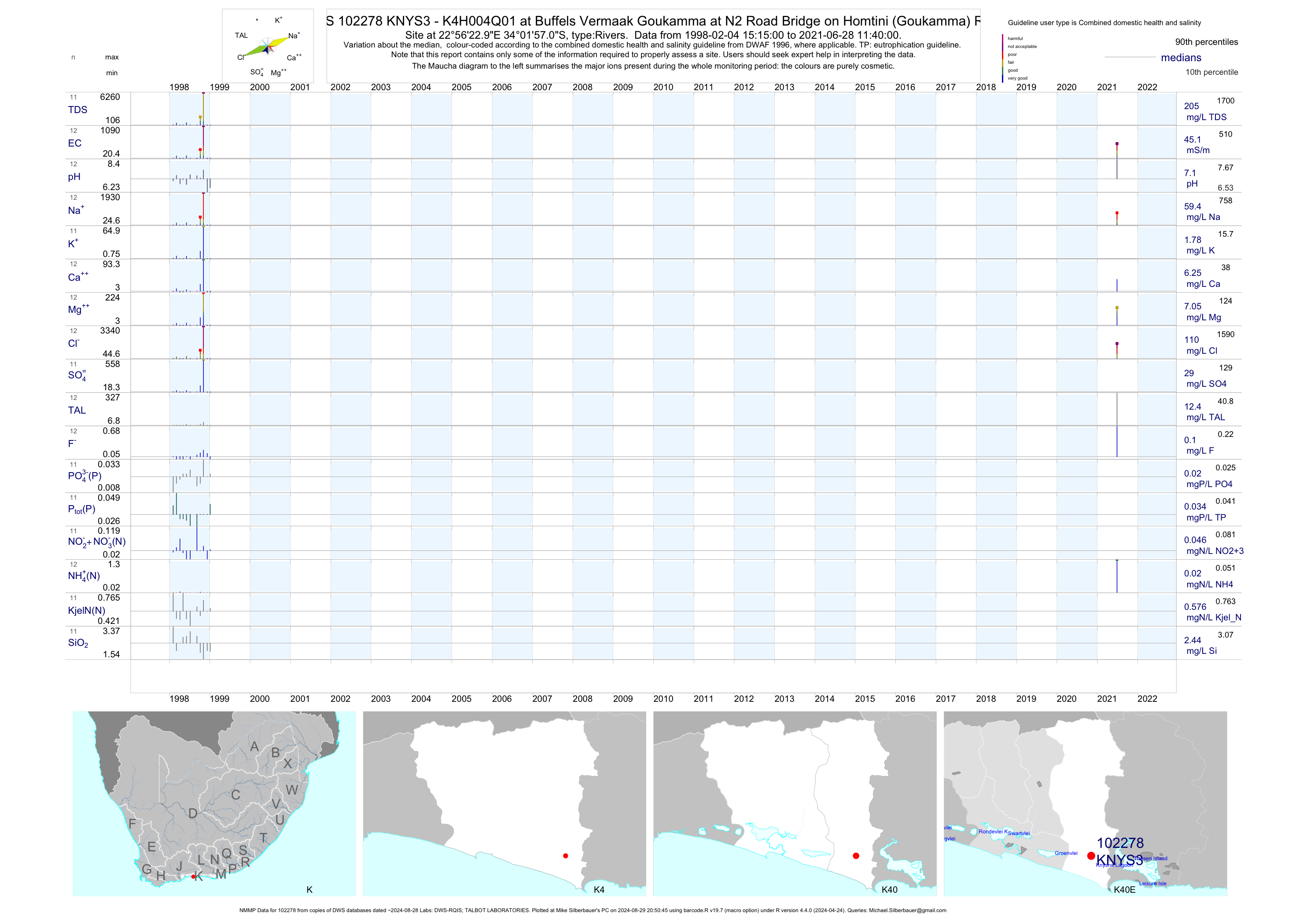
| K40 102278 | plot | data | - K4H004Q01 at Buffels Vermaak Goukamma at N2 Road Bridge on Homtini (Goukamma) River (NMMP) | Rivers | 25 | 1998-02-04 | 2015-01-19 | 43 | KNYS3 | -34.03250 | 22.93972 |
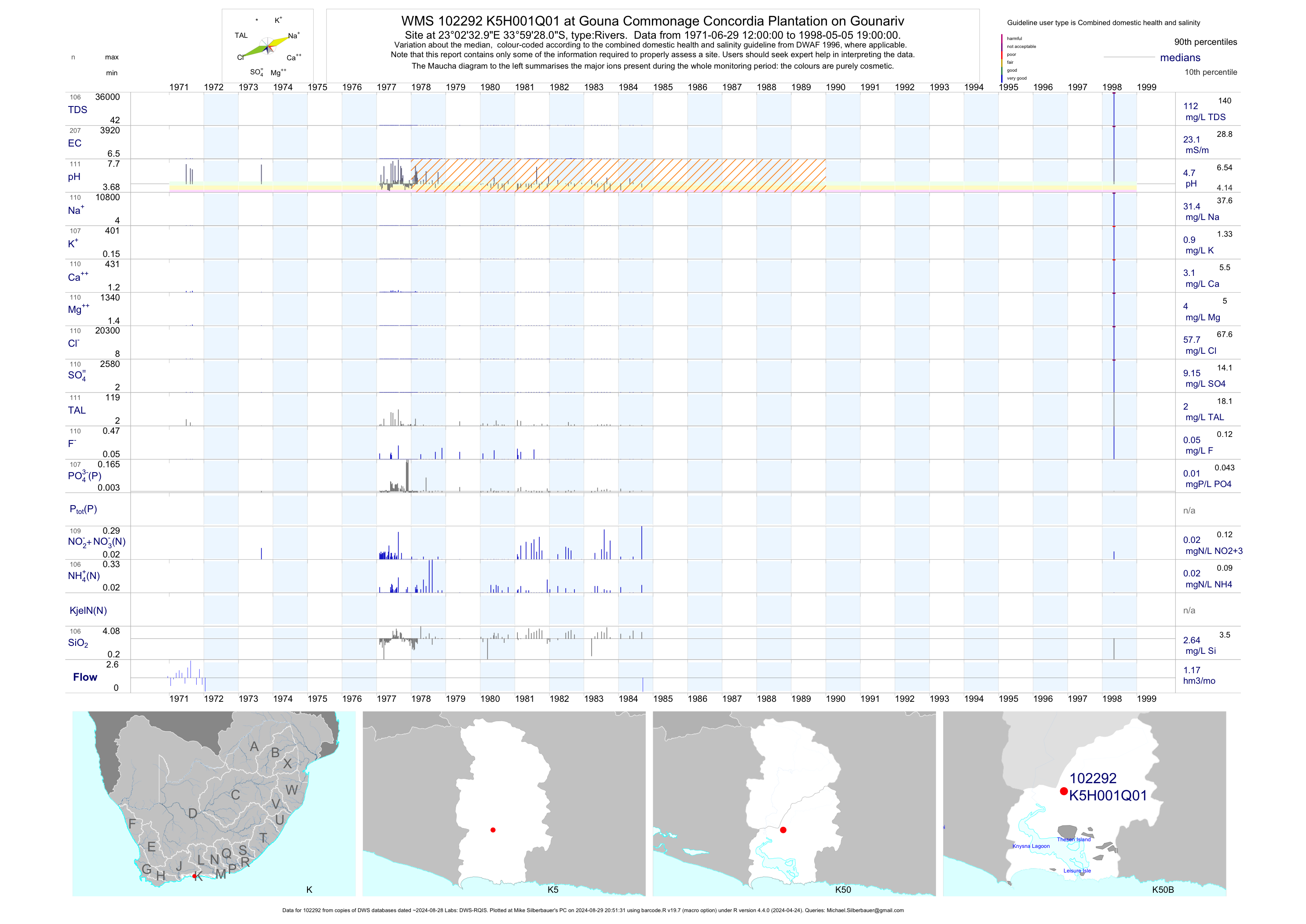
| K50 102292 | plot | data | at Gouna Commonage Concordia Plantation on Gounariv | Rivers | 207 | 1971-06-29 | 1998-05-05 | 23 | K5H001 | -33.99111 | 23.04250 |
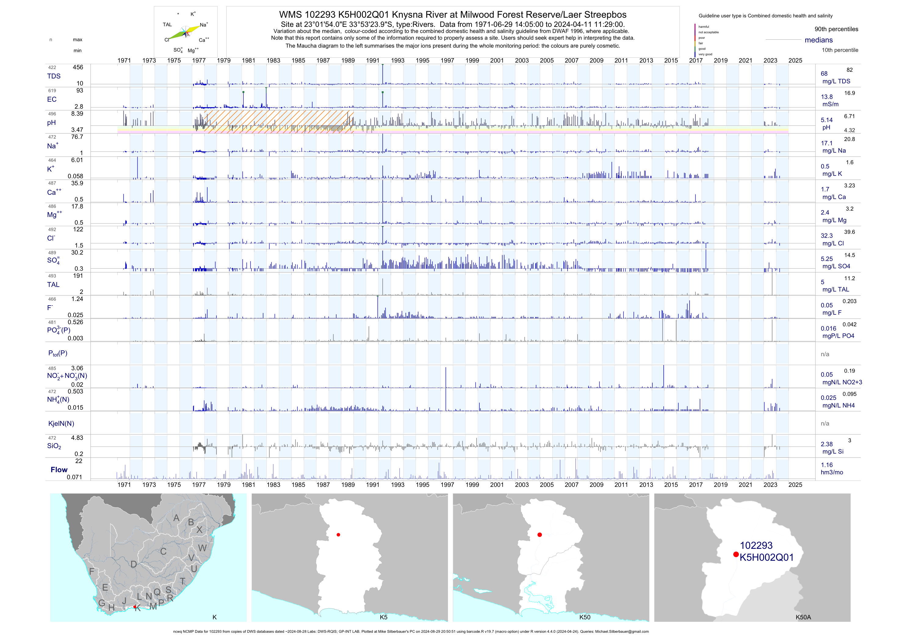
| K50 102293 | plot | data | Knysna River at Milwood Forest Reserve/Laer Streepbos (ncwq NCMP) | Rivers | 610 | 1971-06-29 | 2018-07-05 | 14 | K5H002 | -33.89000 | 23.03167 |
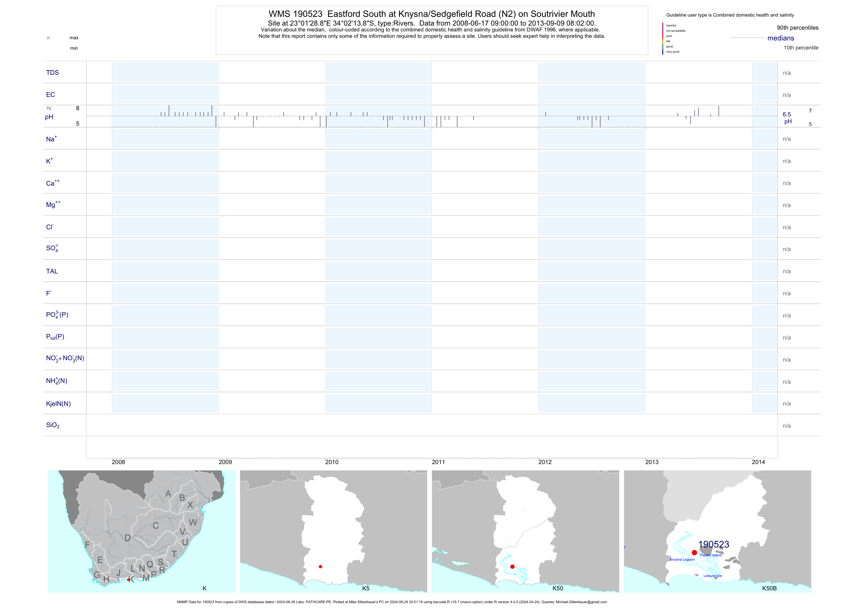
| K50 190523 | plot | data | Eastford South at Knysna/Sedgefield Road (N2) on Soutrivier Mouth (NMMP) | Rivers | 97 | 2008-06-17 | 2013-09-09 | n/a | 190523 | -34.03719 | 23.02469 |
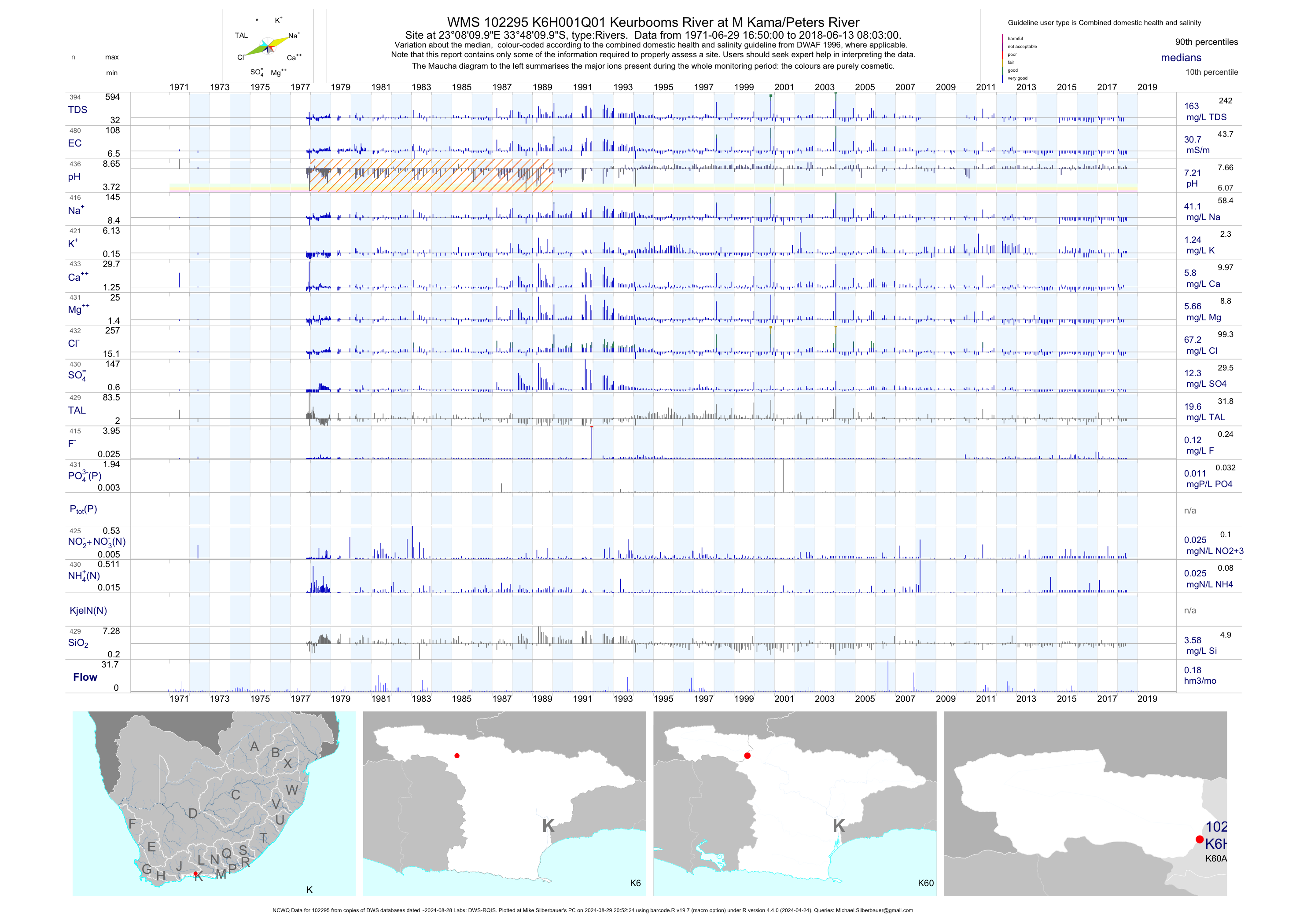
| K60 102295 | plot | data | Keurbooms River at M Kama/Peters River (NCWQ) | Rivers | 483 | 1971-06-29 | 2018-06-13 | 31 | K6H001 | -33.80278 | 23.13611 |
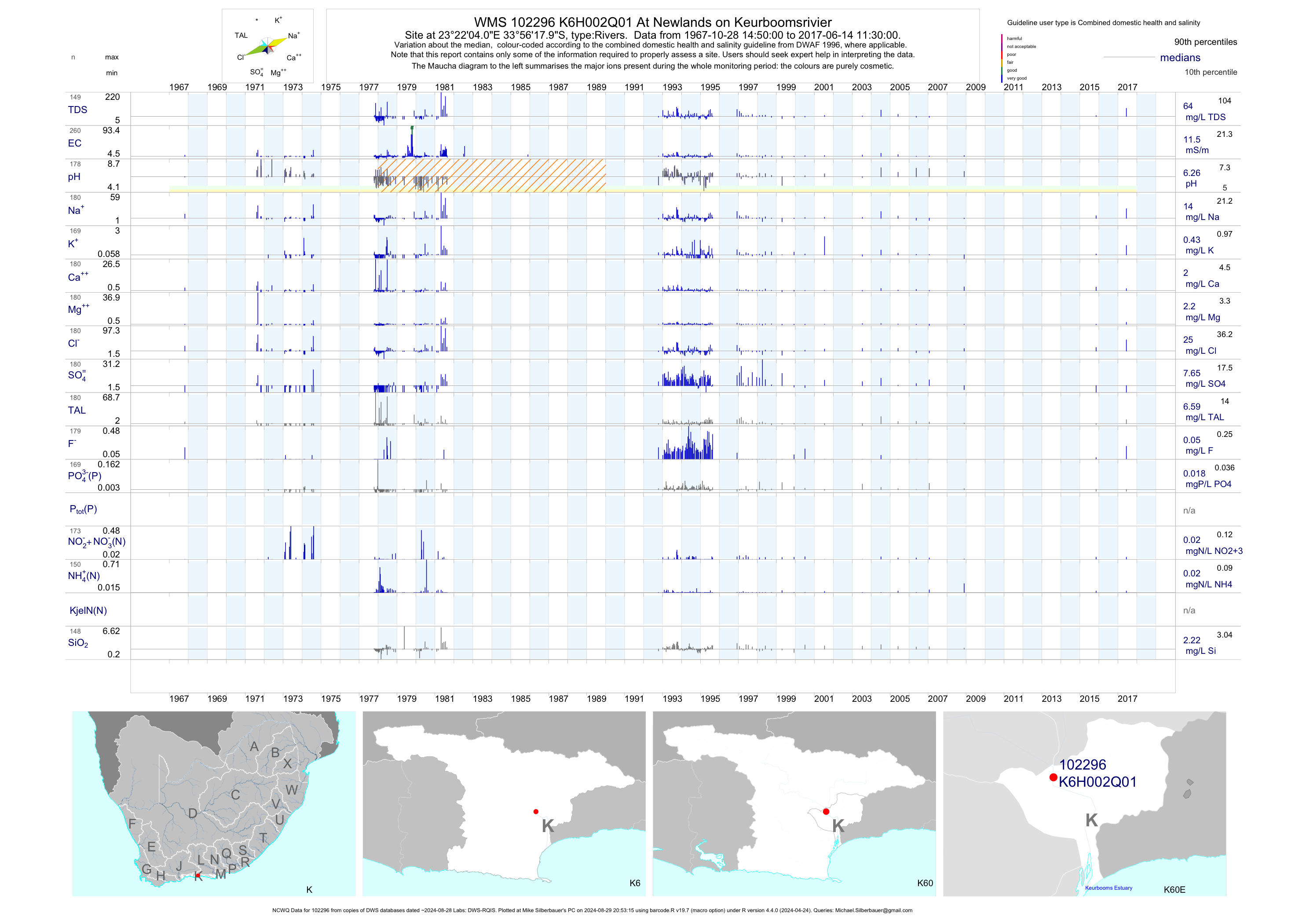
| K60 102296 | plot | data | At Newlands on Keurboomsrivier (NCWQ) | Rivers | 329 | 1967-10-28 | 2017-06-14 | 12 | K6H002 | -33.93833 | 23.36778 |
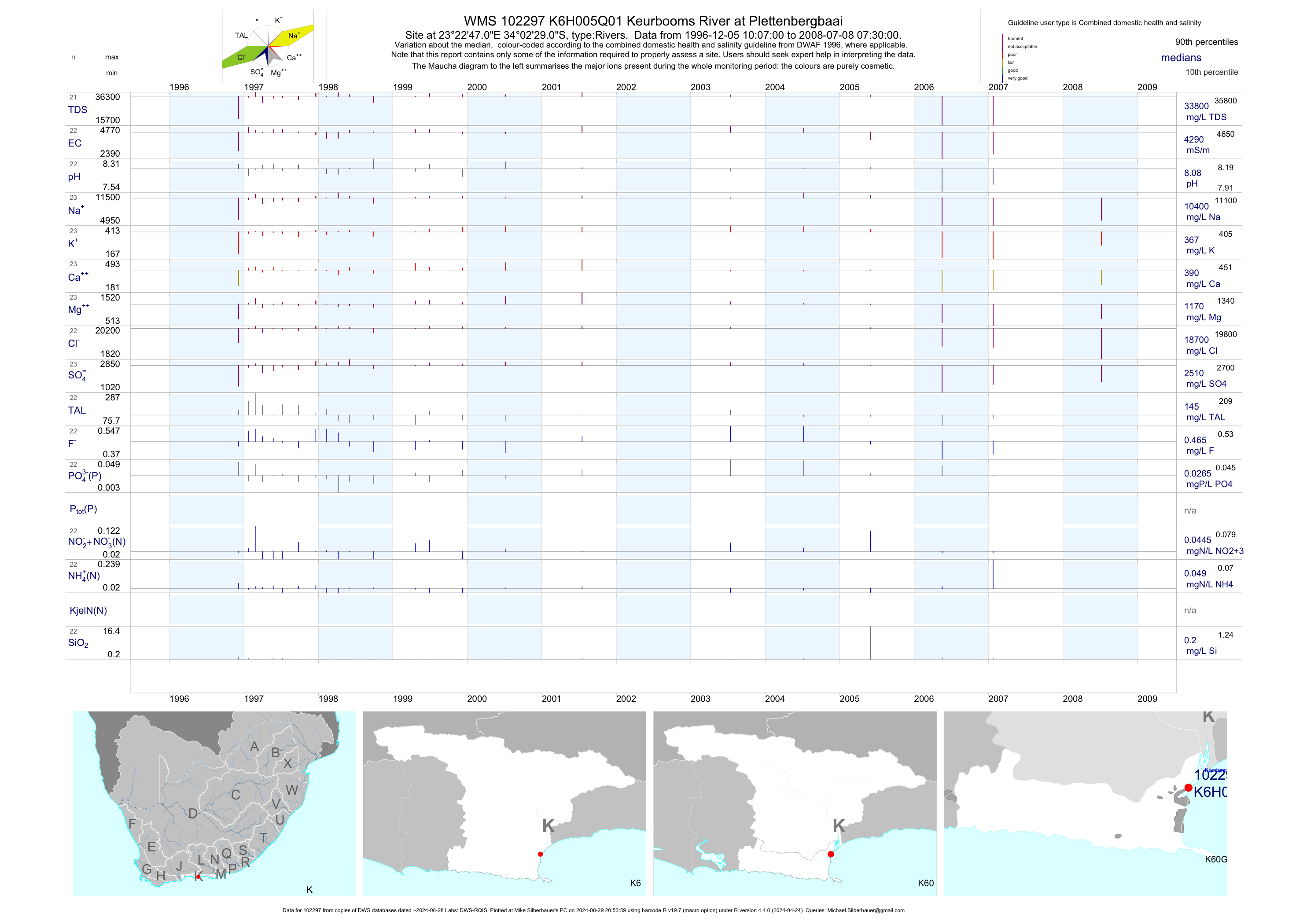
| K60 102297 | plot | data | Keurbooms River at Plettenbergbaai | Rivers | 28 | 1996-12-05 | 2009-06-05 | 4290 | K6H005 | -34.04139 | 23.37972 |
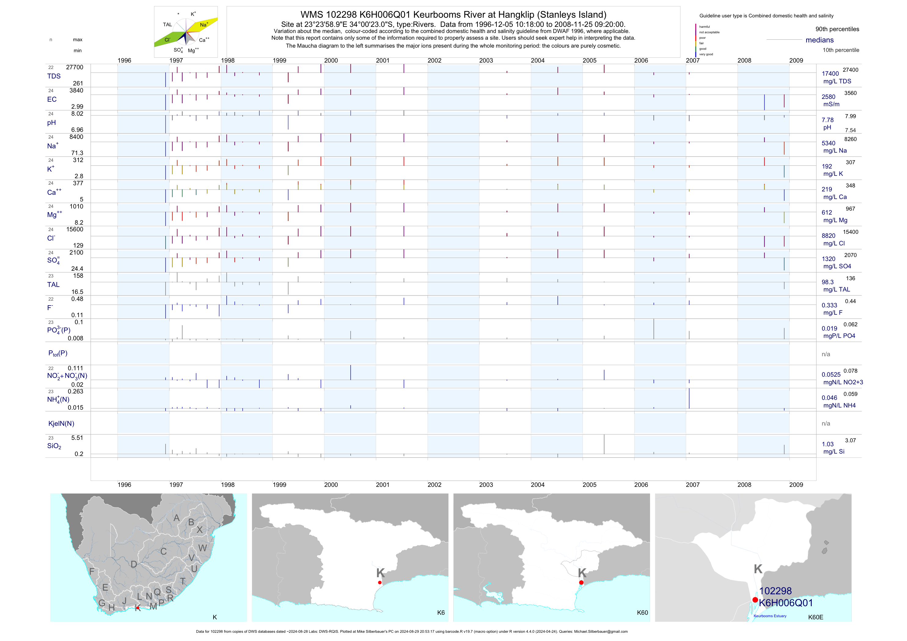
| K60 102298 | plot | data | Keurbooms River at Hangklip (Stanleys Island) | Rivers | 28 | 1996-12-05 | 2009-06-05 | 2580 | K6H006 | -34.00639 | 23.39972 |
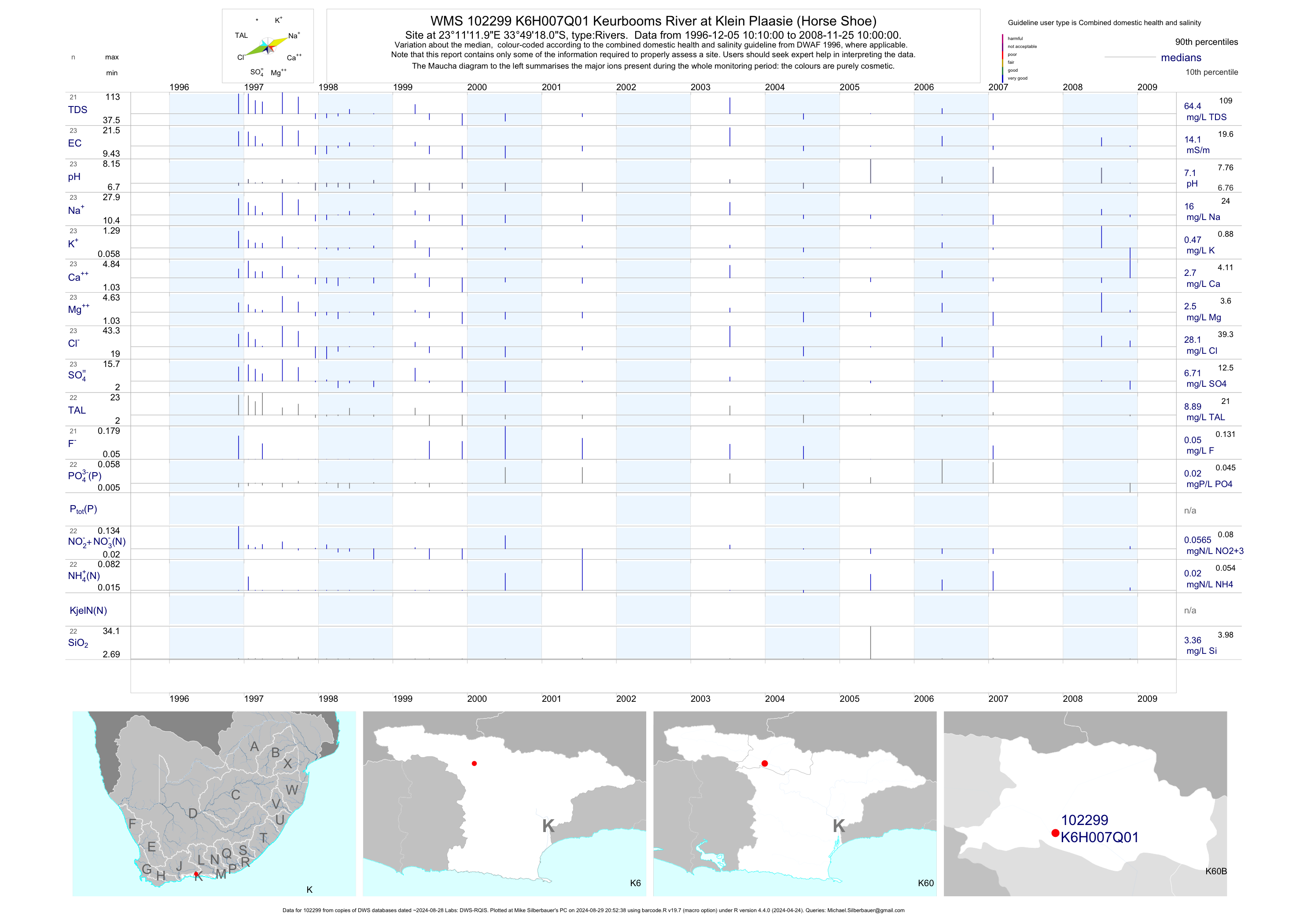
| K60 102299 | plot | data | Keurbooms River at Klein Plaasie (Horse Shoe) | Rivers | 26 | 1996-12-05 | 2008-11-25 | 14 | K6H007 | -33.82167 | 23.18667 |
| K60 102300 | plot | data | Keurbooms River (D/S Kwaai River) at Klein Plaasi | Rivers | 26 | 1996-12-04 | 2008-07-09 | 9 | K6H008 | -33.82139 | 23.18194 |
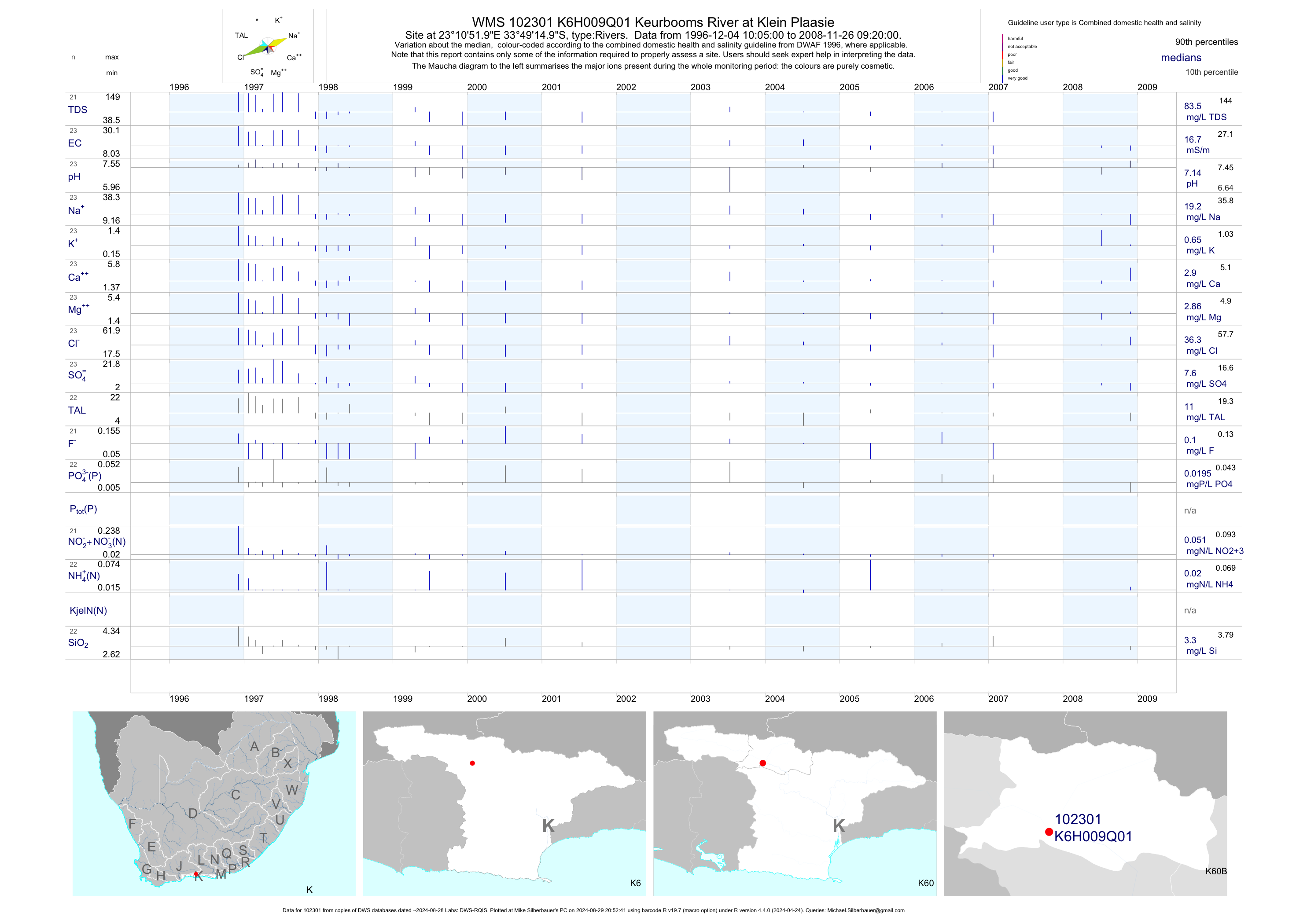
| K60 102301 | plot | data | Keurbooms River at Klein Plaasie | Rivers | 26 | 1996-12-04 | 2008-11-26 | 17 | K6H009 | -33.82083 | 23.18111 |
| K60 102302 | plot | data | Kwaai River at Klein Plaasie | Rivers | 26 | 1996-12-04 | 2008-11-26 | 8 | K6H010 | -33.81528 | 23.18750 |
| K60 102303 | plot | data | Keurbooms River at Klein Plaasie | Rivers | 27 | 1996-12-04 | 2008-11-26 | 29 | K6H011 | -33.81139 | 23.17528 |
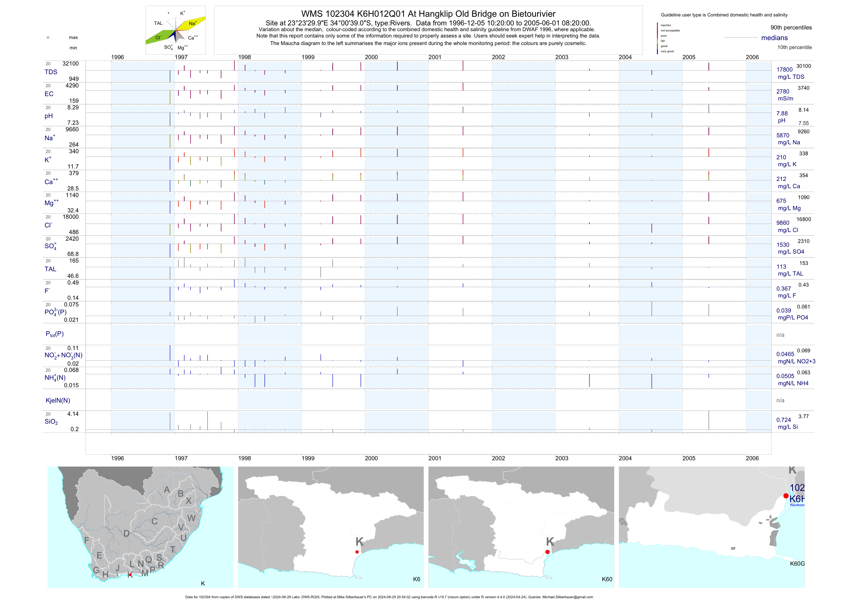
| K60 102304 | plot | data | At Hangklip Old Bridge on Bietourivier | Rivers | 21 | 1996-12-05 | 2005-06-01 | 2775 | K6H012 | -34.01083 | 23.39167 |
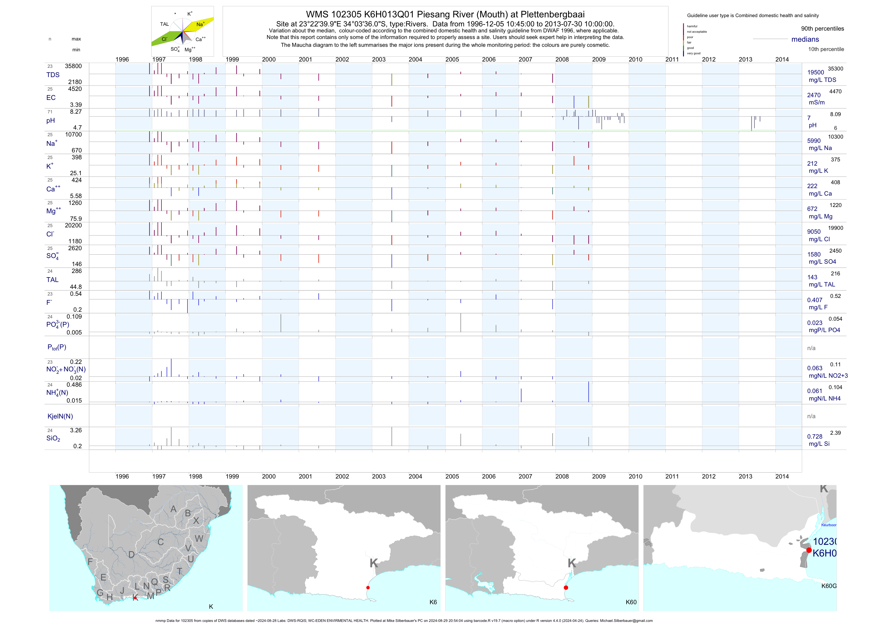
| K60 102305 | plot | data | Piesang River (Mouth) at Plettenbergbaai (nmmp) | Rivers | 138 | 1996-12-05 | 2013-07-30 | 2470 | K6H013 | -34.06000 | 23.37778 |
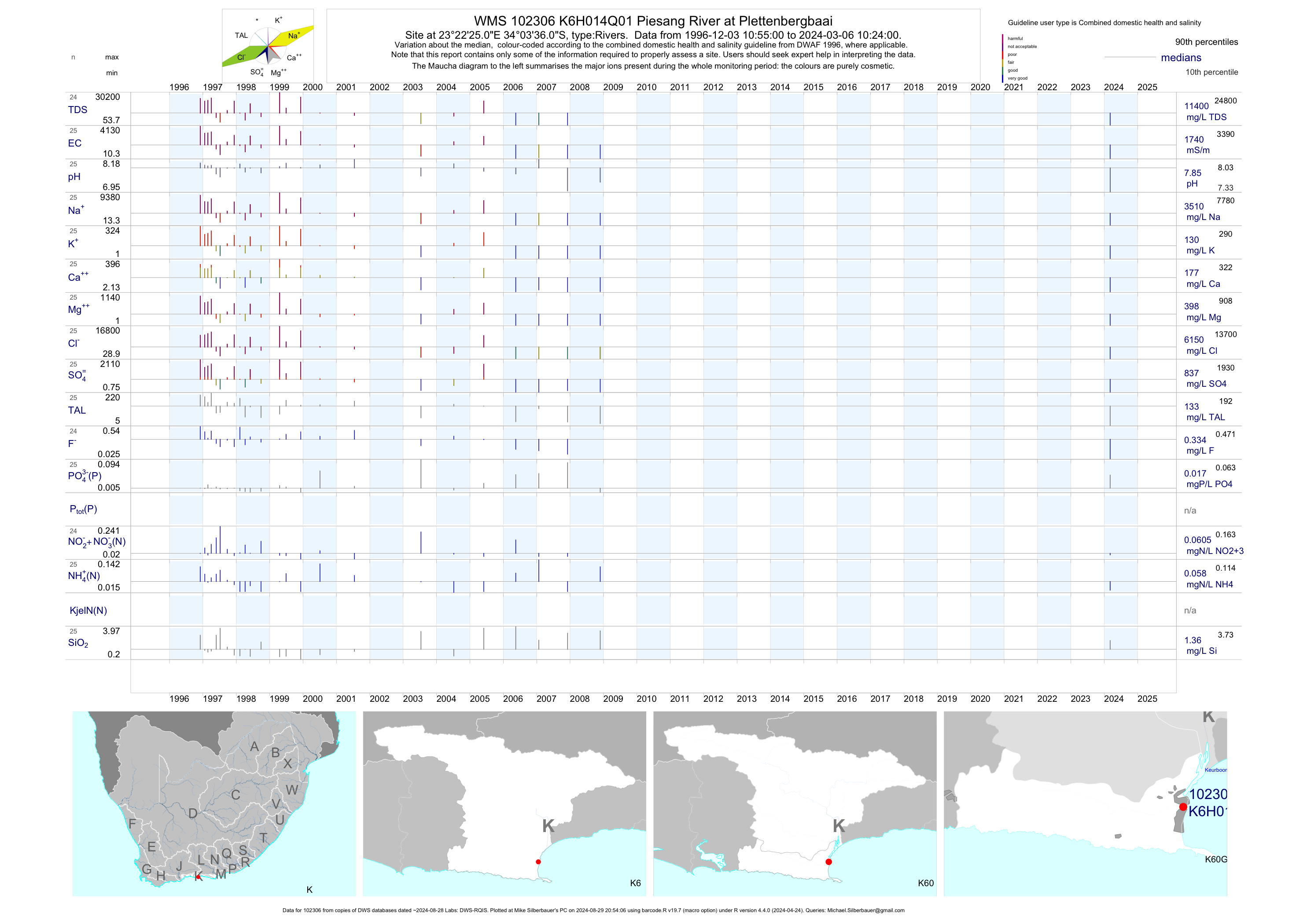
| K60 102306 | plot | data | Piesang River at Plettenbergbaai | Rivers | 28 | 1996-12-03 | 2009-06-05 | 1915 | K6H014 | -34.06000 | 23.37361 |
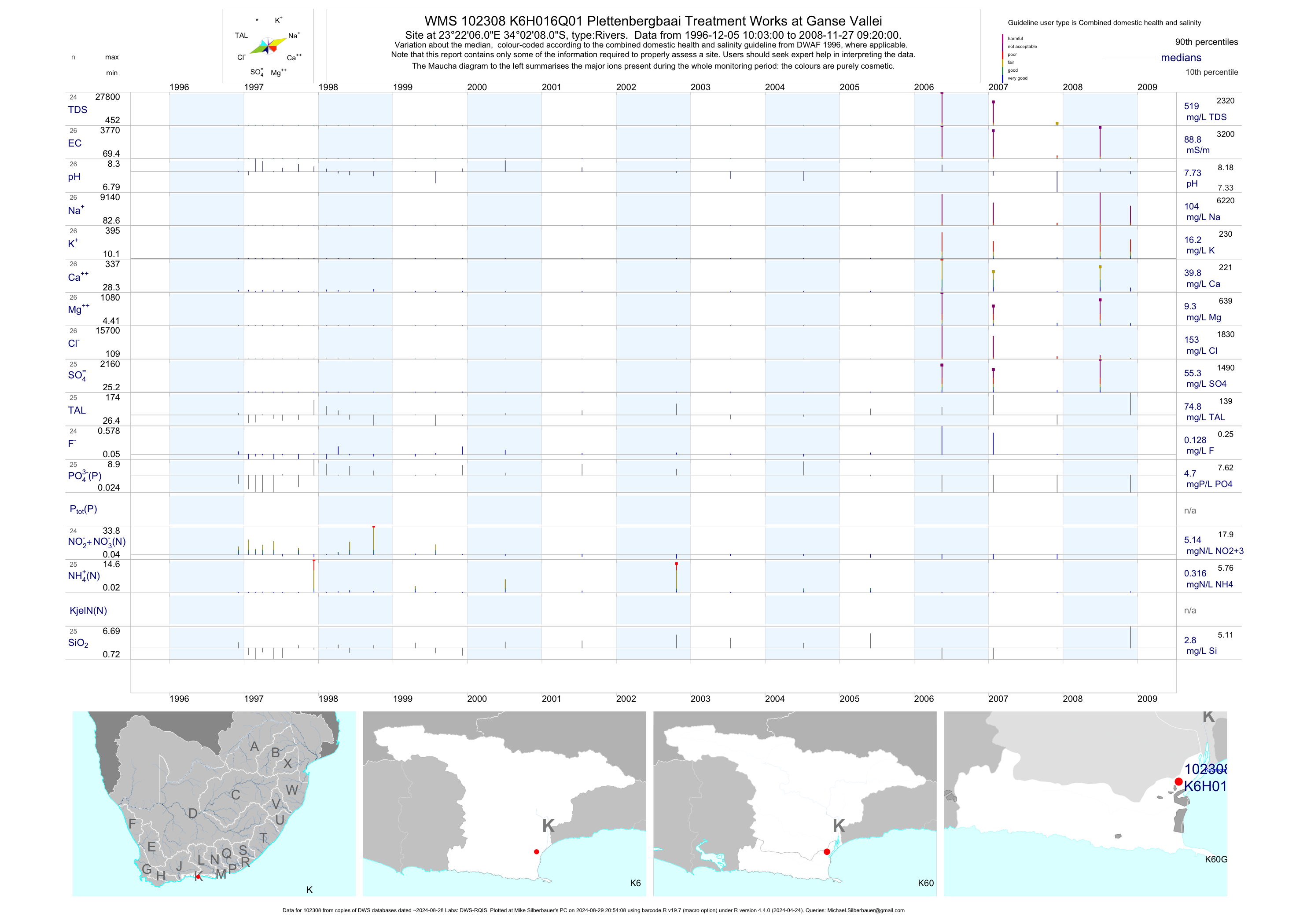
| K60 102308 | plot | data | Plettenbergbaai Treatment Works at Ganse Vallei | Rivers | 28 | 1996-12-05 | 2008-11-27 | 89 | K6H016 | -34.03556 | 23.36833 |
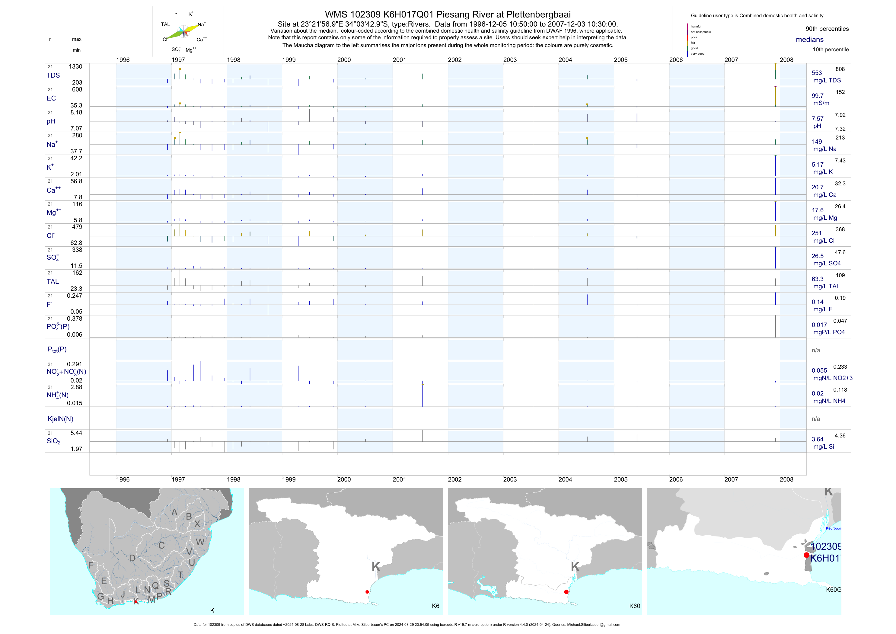
| K60 102309 | plot | data | Piesang River at Plettenbergbaai | Rivers | 31 | 1996-12-05 | 2007-12-03 | 100 | K6H017 | -34.06194 | 23.36583 |
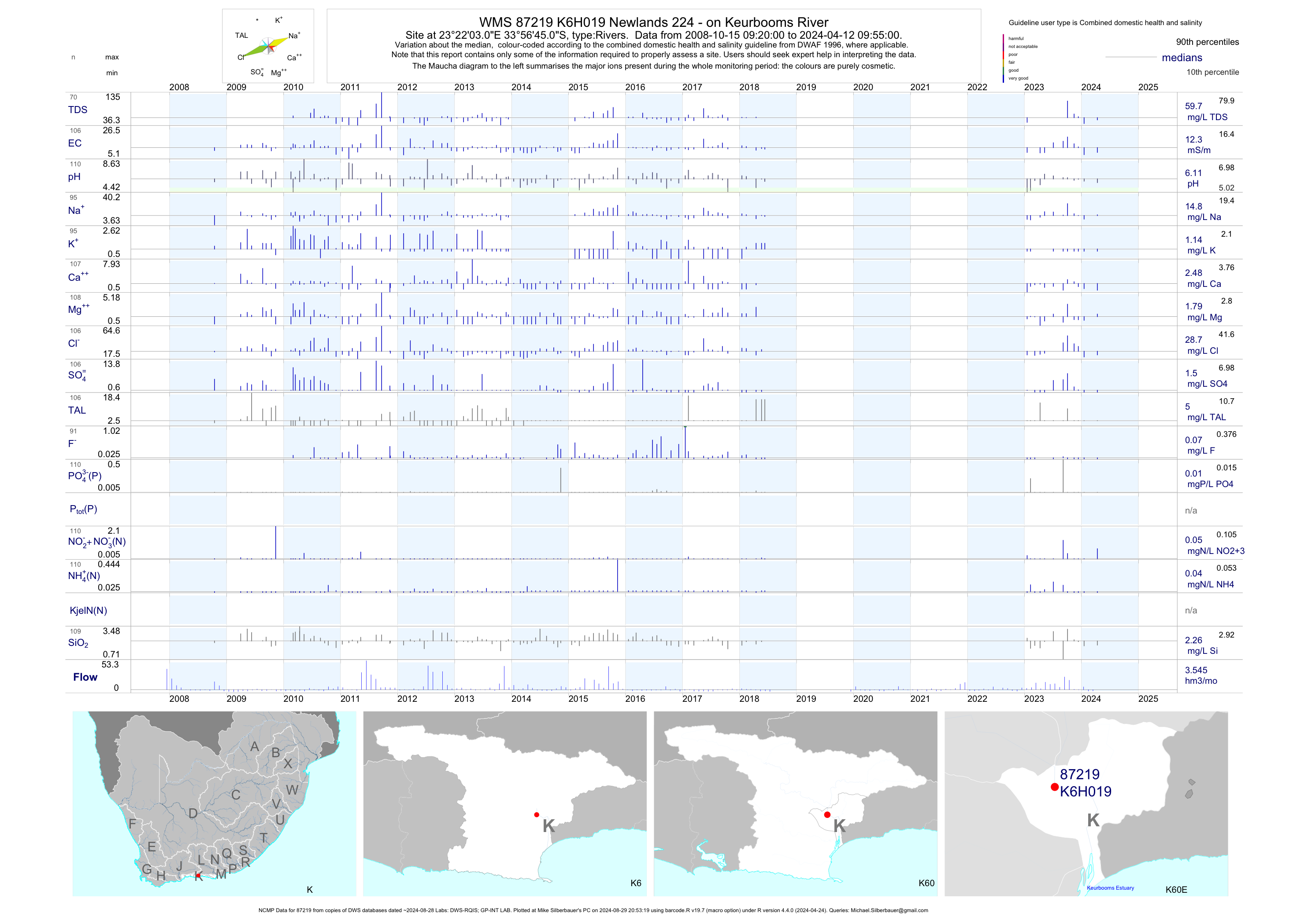
| K60 87219 | plot | data | Newlands 224 - on Keurbooms River (NCMP) | Rivers | 98 | 2008-10-15 | 2018-06-12 | 12 | K6H019 | -33.94583 | 23.36750 |
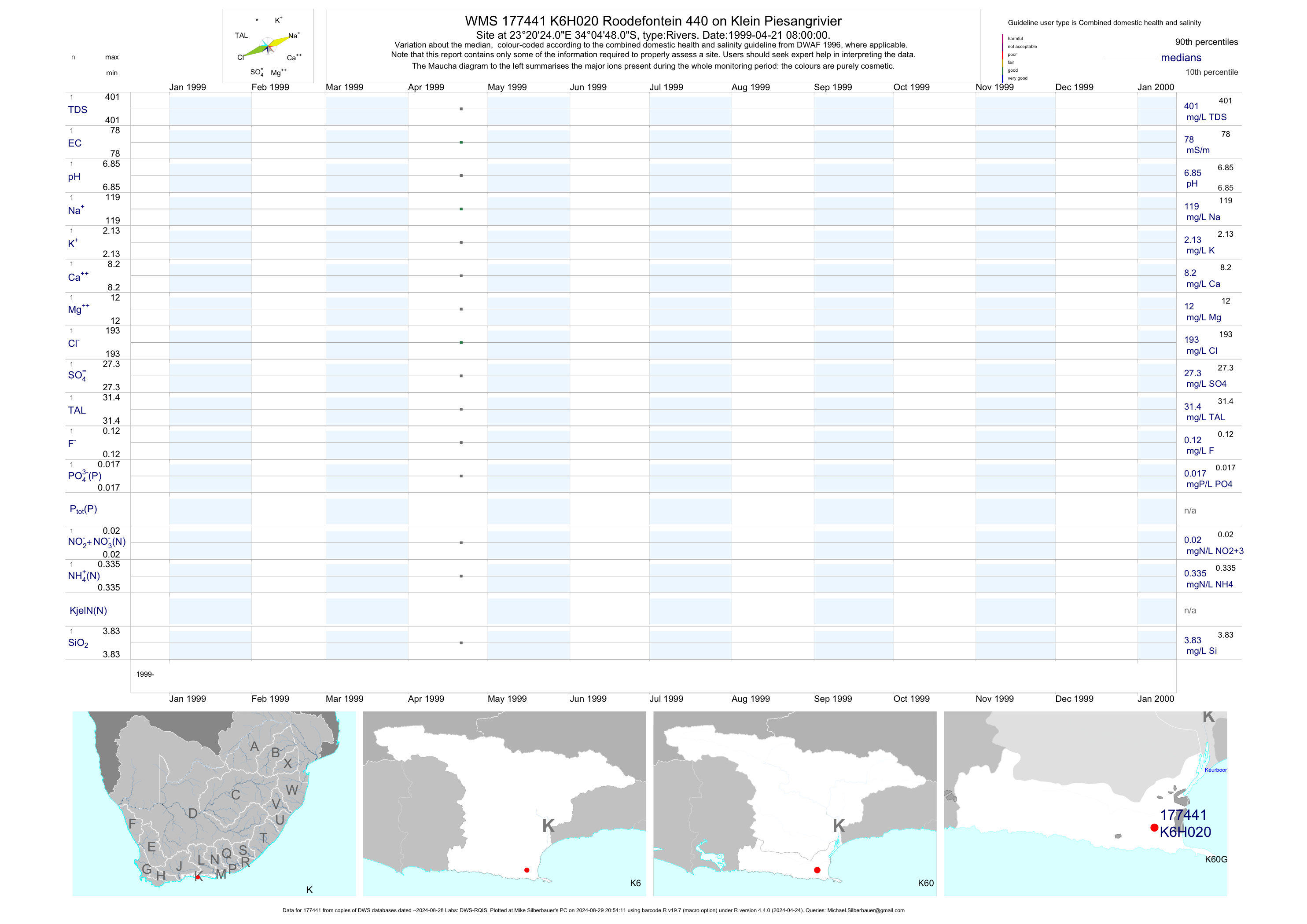
| K60 177441 | plot | data | Roodefontein 440 on Klein Piesangrivier | Rivers | 3 | 1999-04-21 | 2003-07-15 | 78 | K6H020 | -34.08000 | 23.34000 |
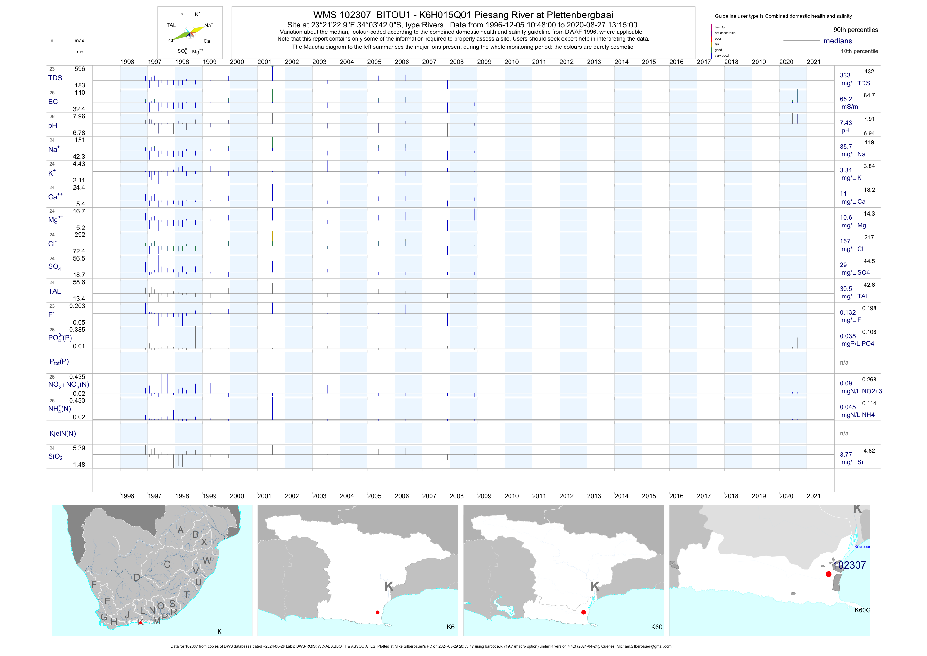
| K60 102307 | plot | data | BITOU1 - K6H015Q01 Piesang River at Plettenbergbaai | Rivers | 30 | 1996-12-05 | 2009-06-05 | 62 | 102307 | -34.06167 | 23.35639 |
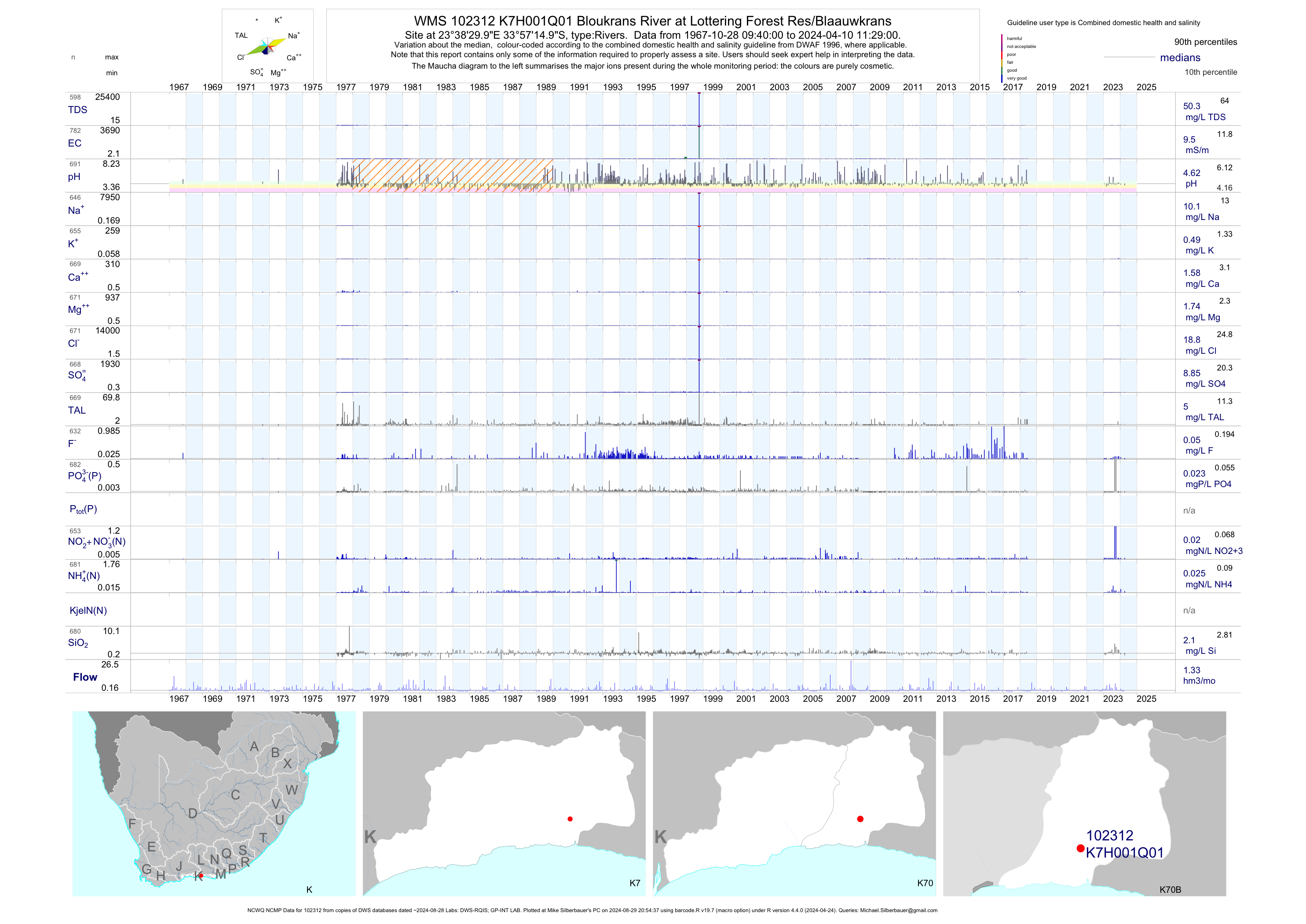
| K70 102312 | plot | data | Bloukrans River at Lottering Forest Res/Blaauwkrans (NCWQ NCMP) | Rivers | 859 | 1967-10-28 | 2018-06-12 | 10 | K7H001 | -33.95417 | 23.64167 |
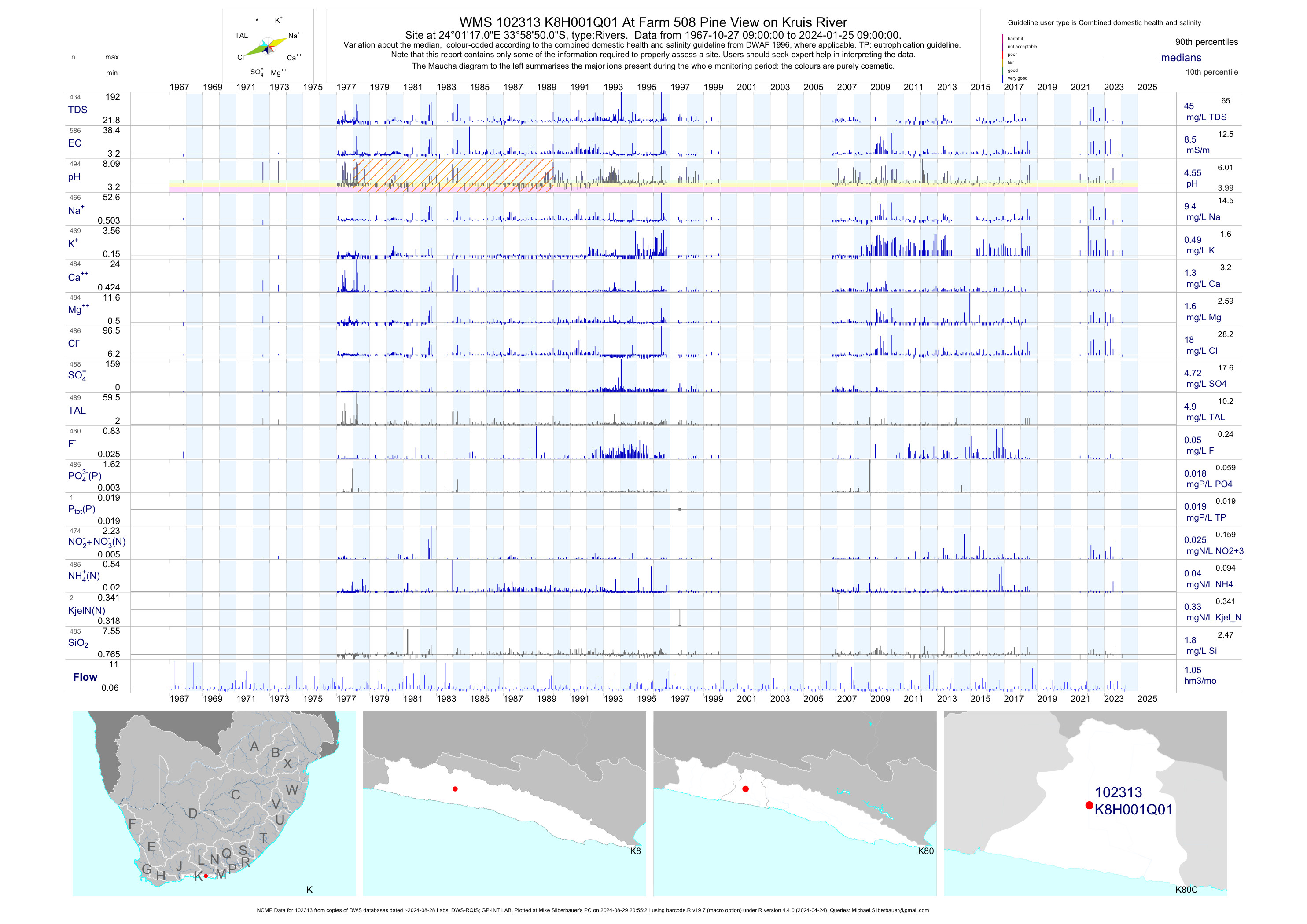
| K80 102313 | plot | data | At Farm 508 Pine View on Kruis River (NCMP) | Rivers | 660 | 1967-10-27 | 2018-07-04 | 8 | K8H001 | -33.98056 | 24.02139 |
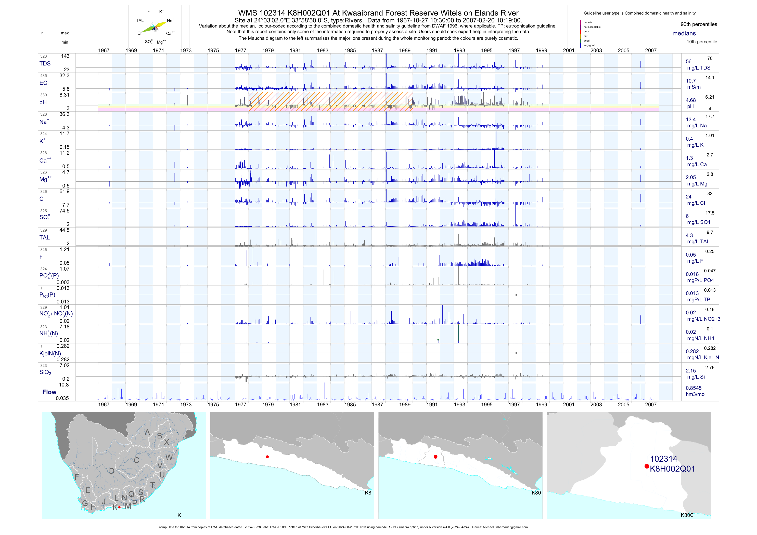
| K80 102314 | plot | data | At Kwaaibrand Forest Reserve Witels on Elands River (ncmp) | Rivers | 525 | 1967-10-27 | 2007-02-20 | 11 | K8H002 | -33.98056 | 24.05056 |
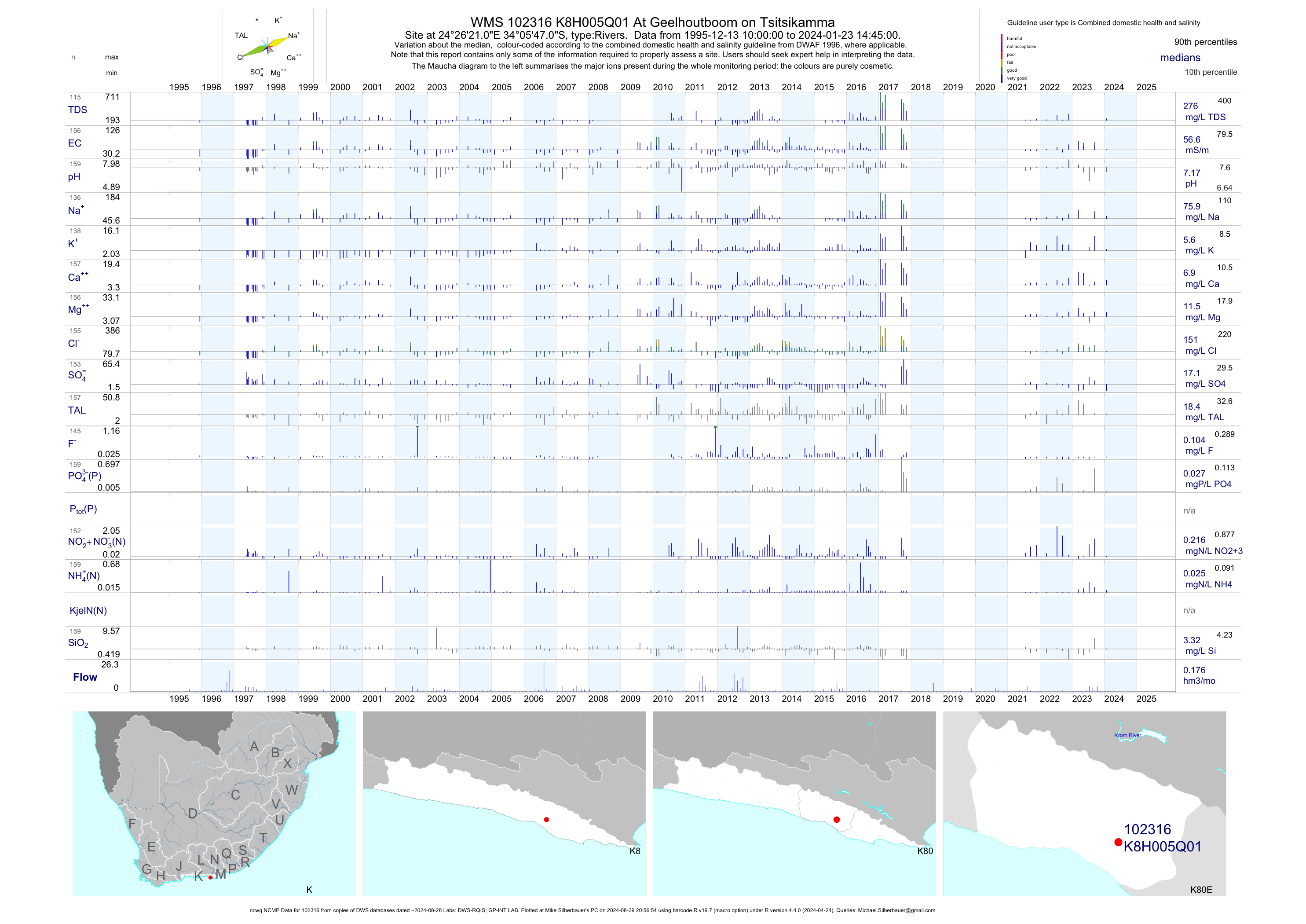
| K80 102316 | plot | data | At Geelhoutboom on Tsitsikamma (ncwq NCMP) | Rivers | 148 | 1995-12-13 | 2017-11-08 | 56 | K8H005 | -34.09639 | 24.43917 |
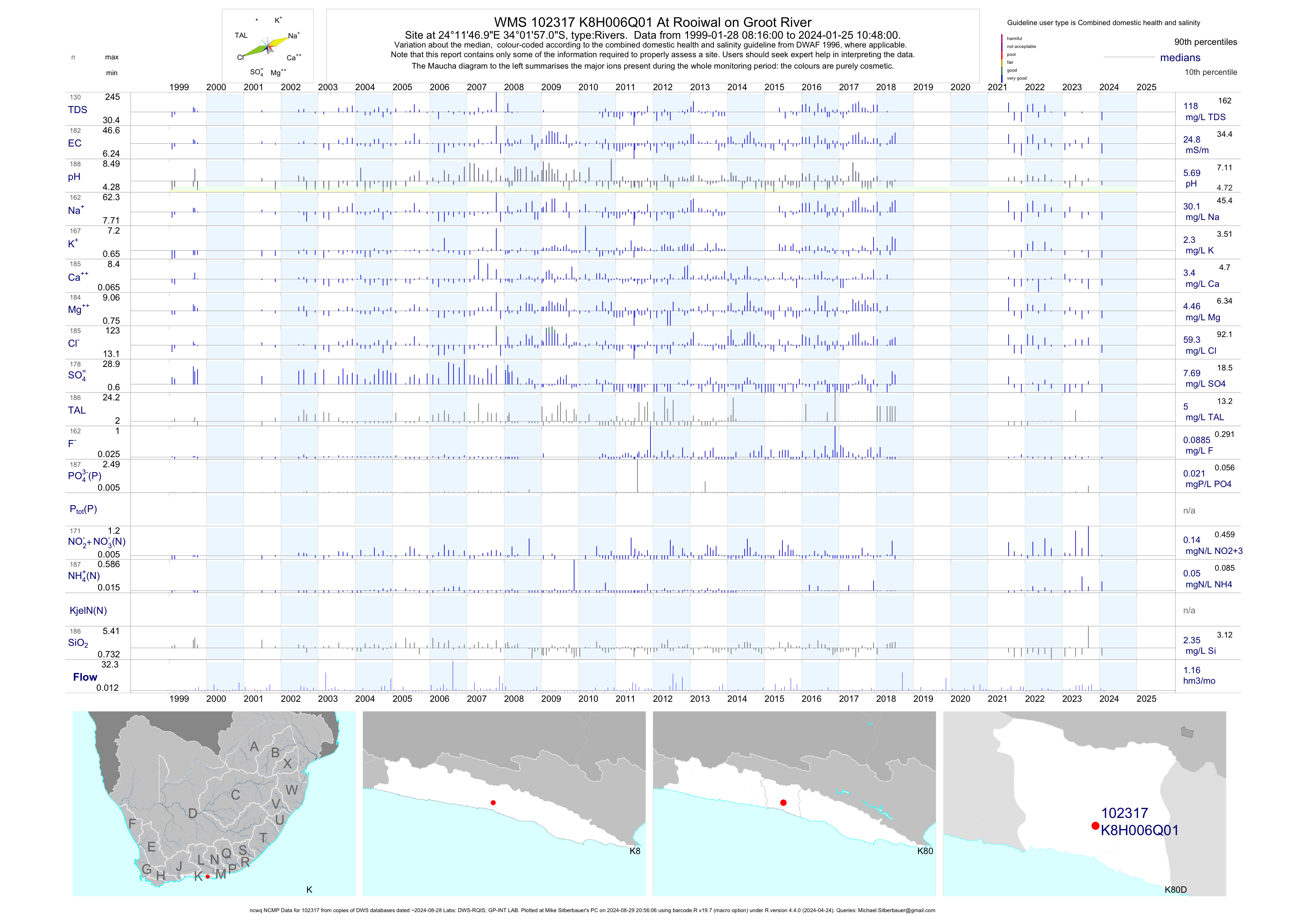
| K80 102317 | plot | data | At Rooiwal on Groot River (ncwq NCMP) | Rivers | 175 | 1999-01-28 | 2018-07-04 | 25 | K8H006 | -34.03250 | 24.19639 |
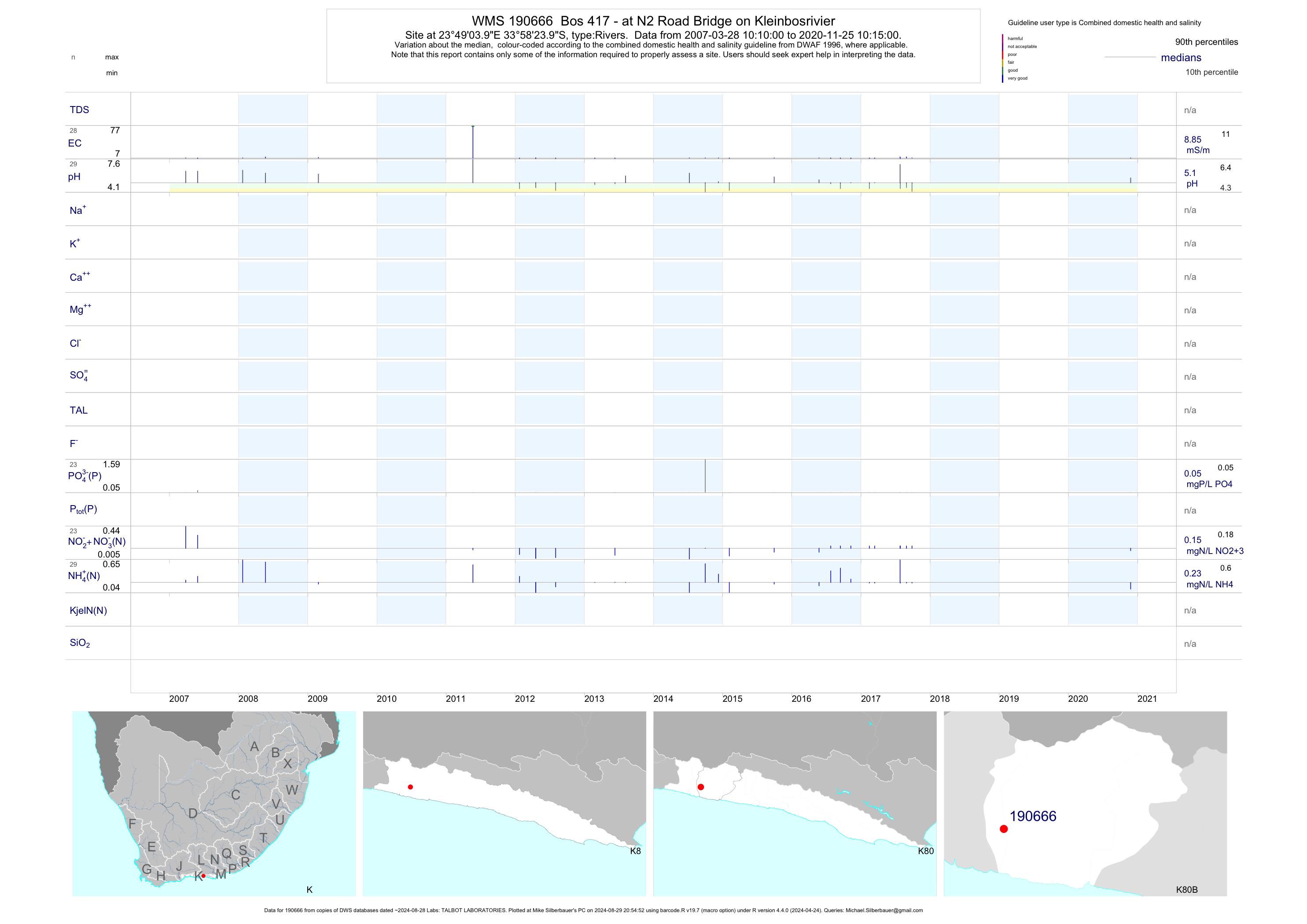
| K80 190666 | plot | data | Bos 417 - at N2 Road Bridge on Kleinbosrivier | Rivers | 52 | 2007-03-28 | 2017-09-27 | 8 | 190666 | -33.97333 | 23.81778 |
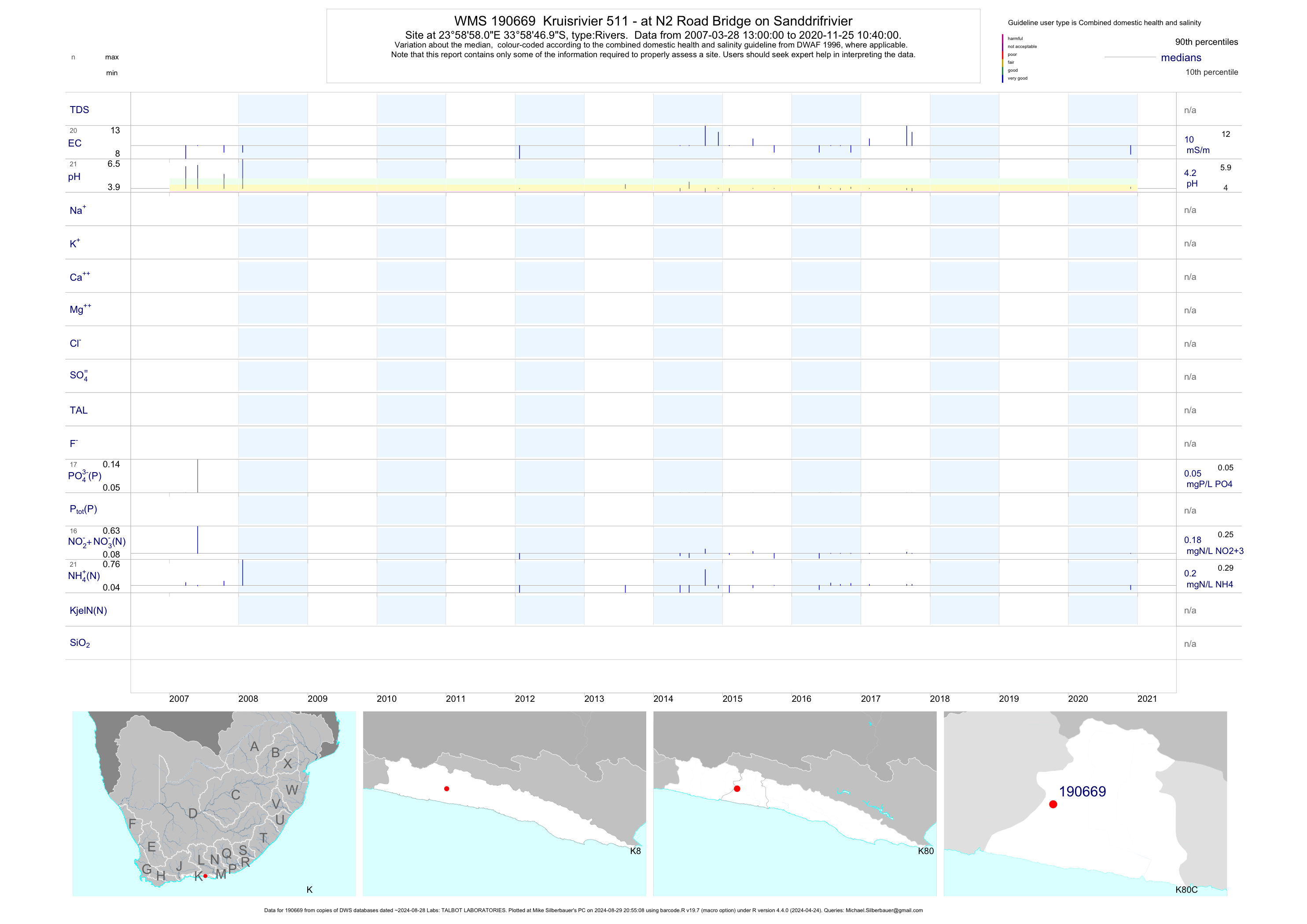
| K80 190669 | plot | data | Kruisrivier 511 - at N2 Road Bridge on Sanddrifrivier | Rivers | 39 | 2007-03-28 | 2017-09-27 | 10 | 190669 | -33.97972 | 23.98278 |
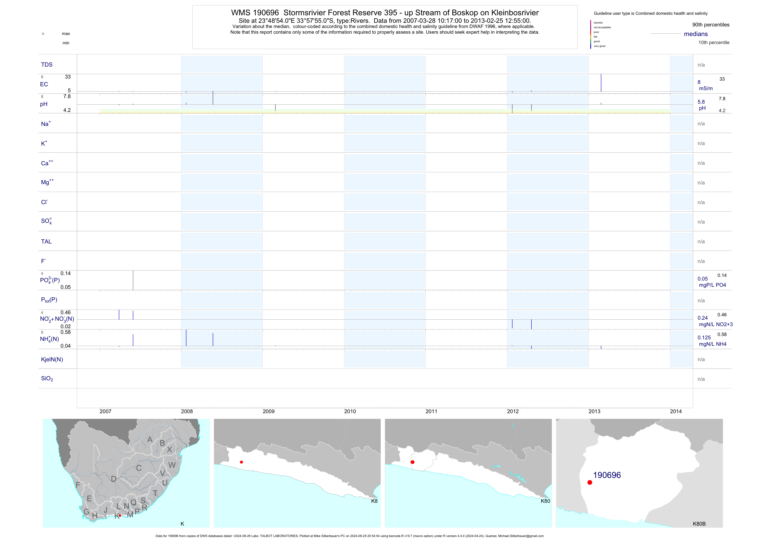
| K80 190696 | plot | data | Stormsrivier Forest Reserve 395 - up Stream of Boskop on Kleinbosrivier | Rivers | 17 | 2007-03-28 | 2013-02-25 | 8 | 190696 | -33.96528 | 23.81500 |
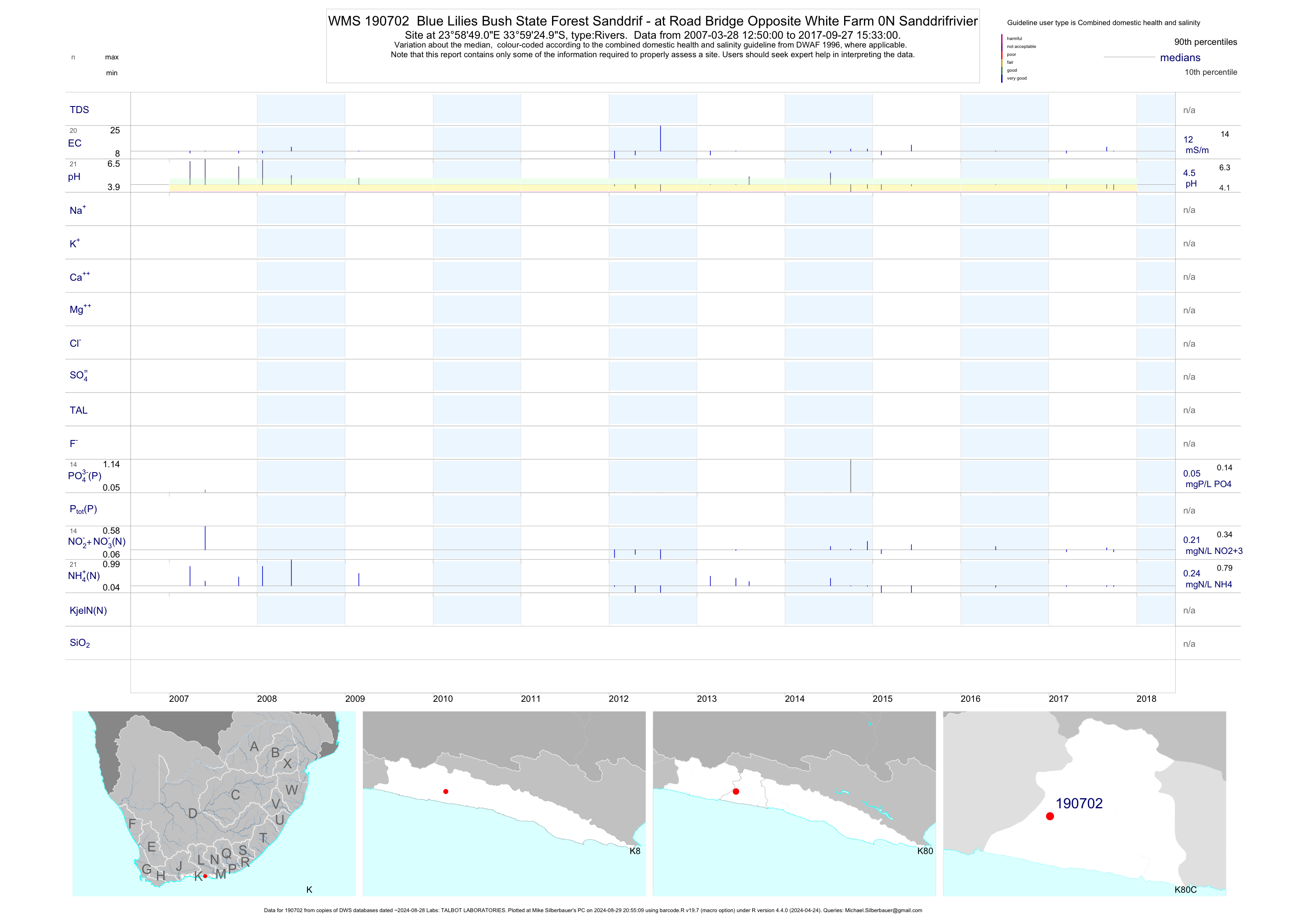
| K80 190702 | plot | data | Blue Lilies Bush State Forest Sanddrif - at Road Bridge Opposite White Farm 0N Sanddrifrivier | Rivers | 41 | 2007-03-28 | 2017-09-27 | 12 | 190702 | -33.99028 | 23.98028 |
| K80 1000011449 | plot | data | Low Bridge on R102 | Rivers | 22 | 2007-03-28 | 2012-04-19 | 10 | 1-11449 | -33.97292 | 23.74714 |
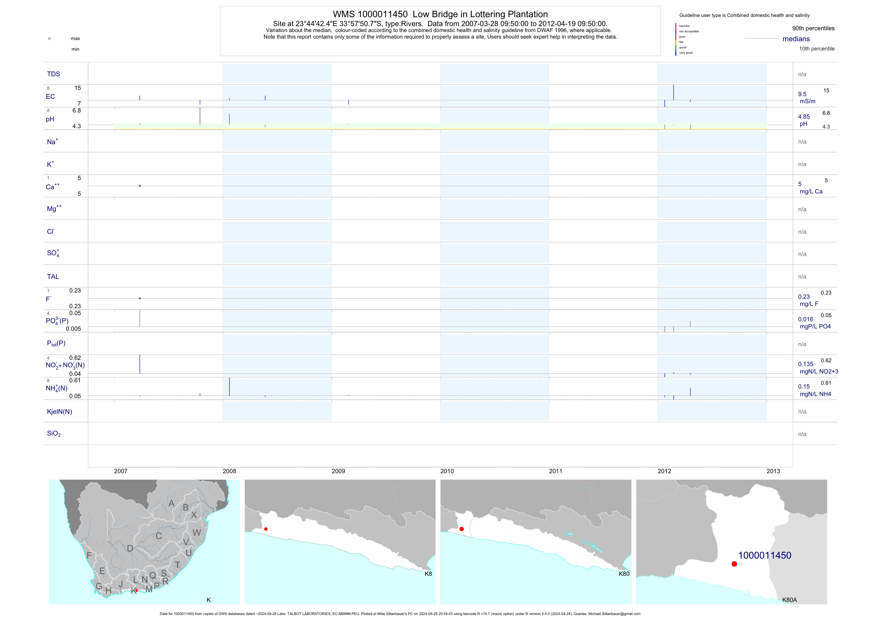
| K80 1000011450 | plot | data | Low Bridge in Lottering Plantation | Rivers | 17 | 2007-03-28 | 2012-04-19 | 10 | 1-11450 | -33.96408 | 23.74511 |
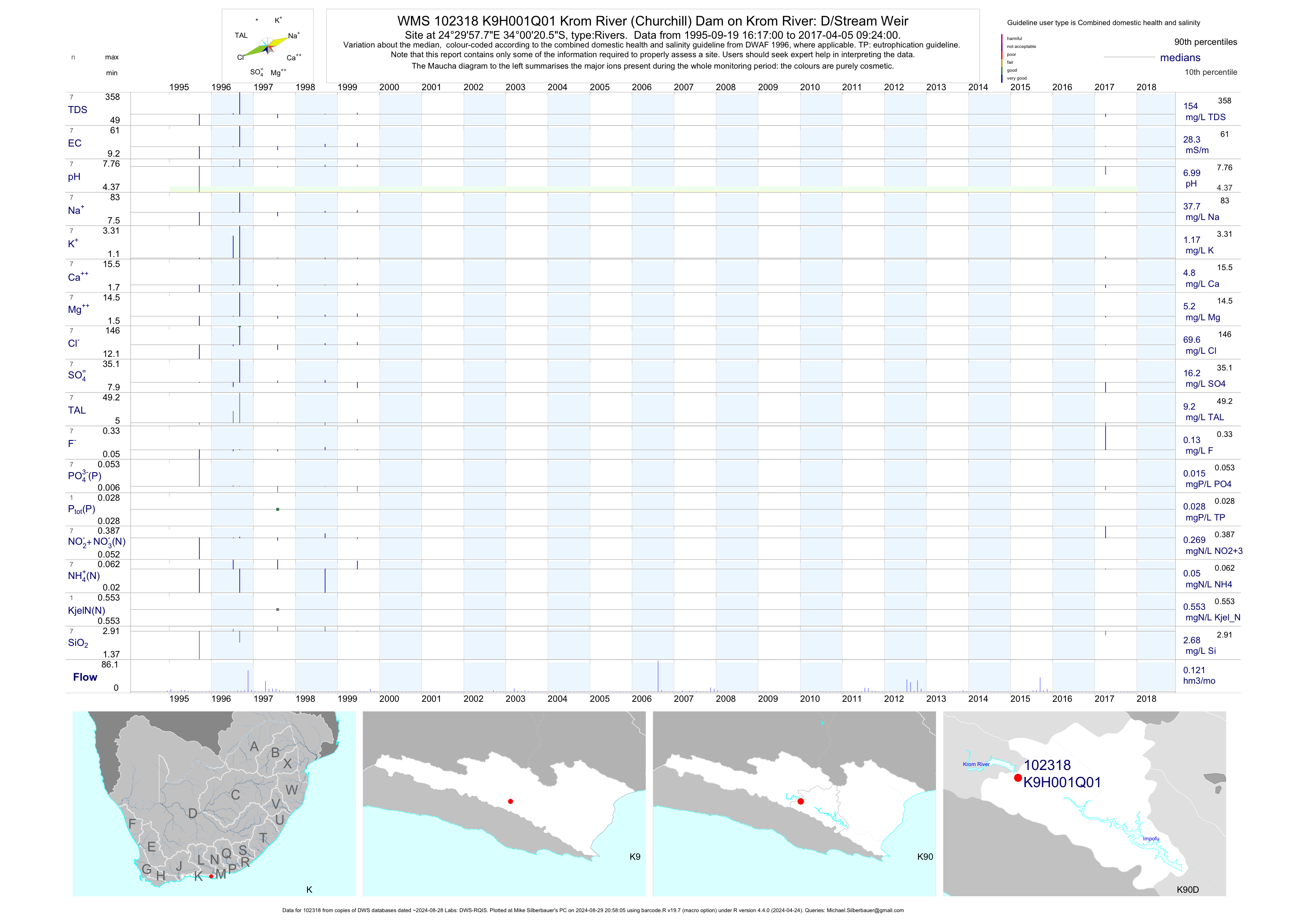
| K90 102318 | plot | data | Krom River (Churchill) Dam on Krom River: D/Stream Weir | Rivers | 9 | 1995-04-18 | 2017-04-05 | 28 | K9H001 | -34.00569 | 24.49938 |
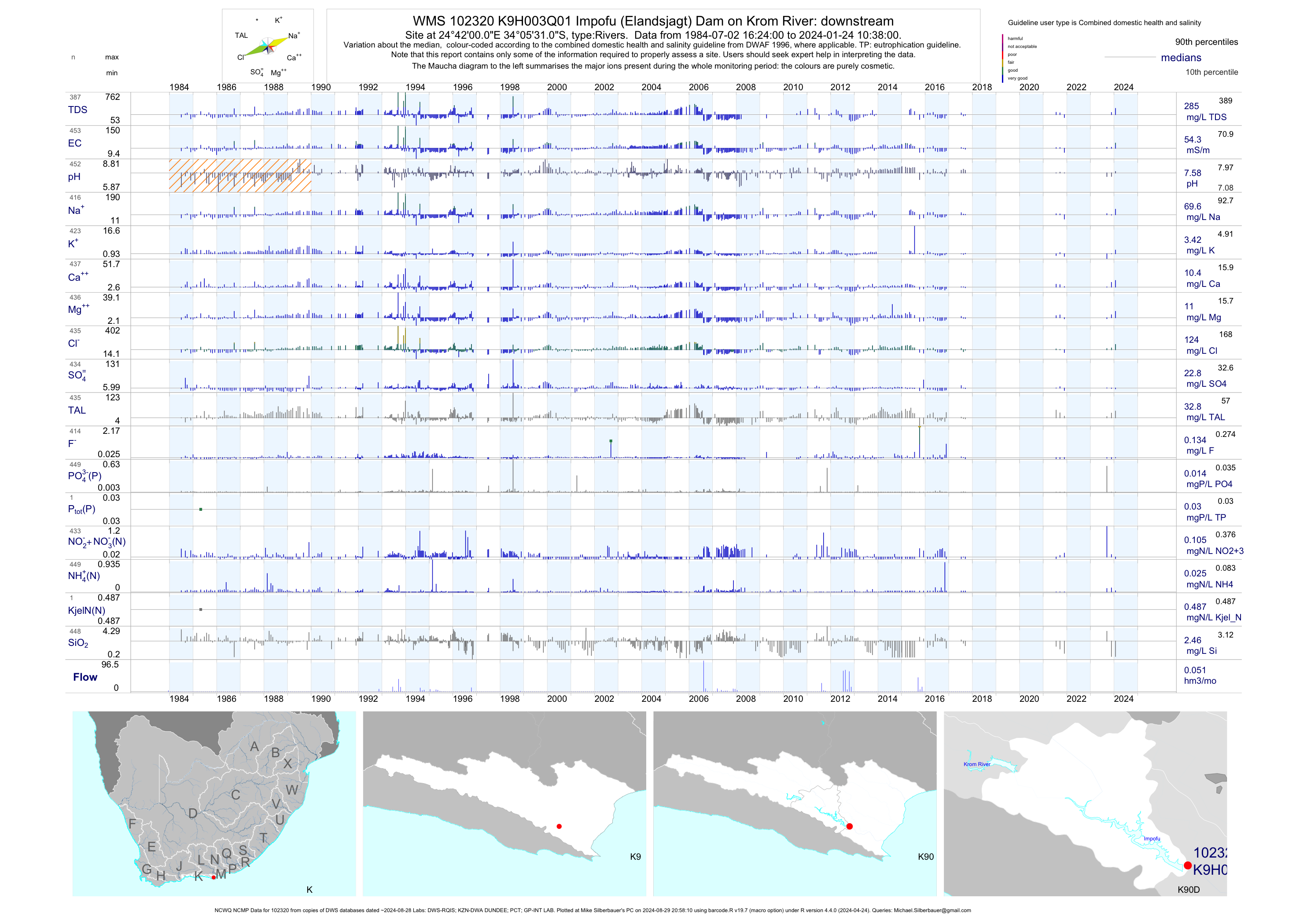
| K90 102320 | plot | data | Impofu (Elandsjagt) Dam on Krom River: downstream (NCWQ NCMP) | Rivers | 540 | 1984-07-02 | 2017-09-14 | 54 | K9H003 | -34.09194 | 24.70000 |
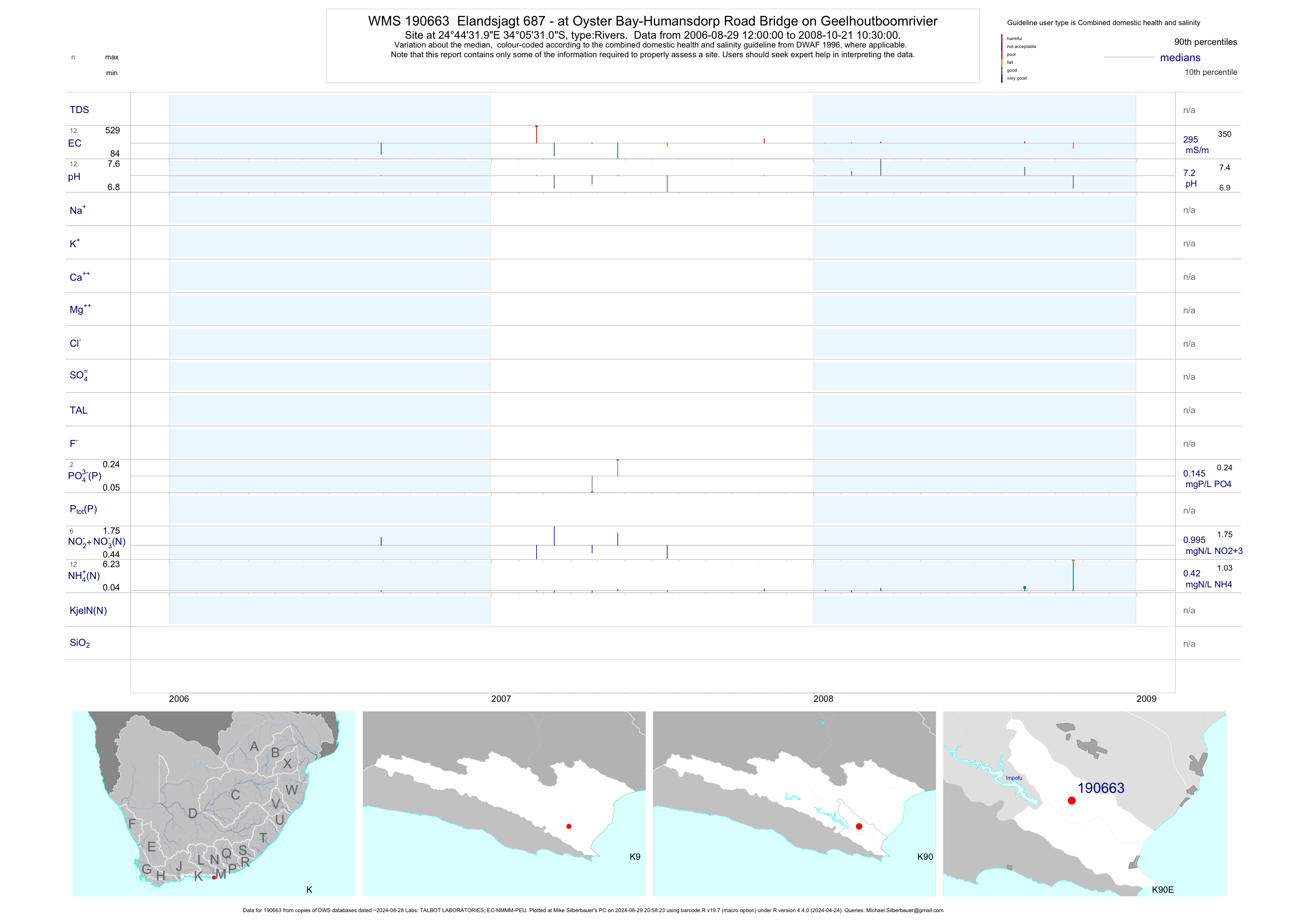
| K90 190663 | plot | data | Elandsjagt 687 - at Oyster Bay-Humansdorp Road Bridge on Geelhoutboomrivier | Rivers | 24 | 2006-08-29 | 2008-10-21 | 295 | 190663 | -34.09194 | 24.74222 |
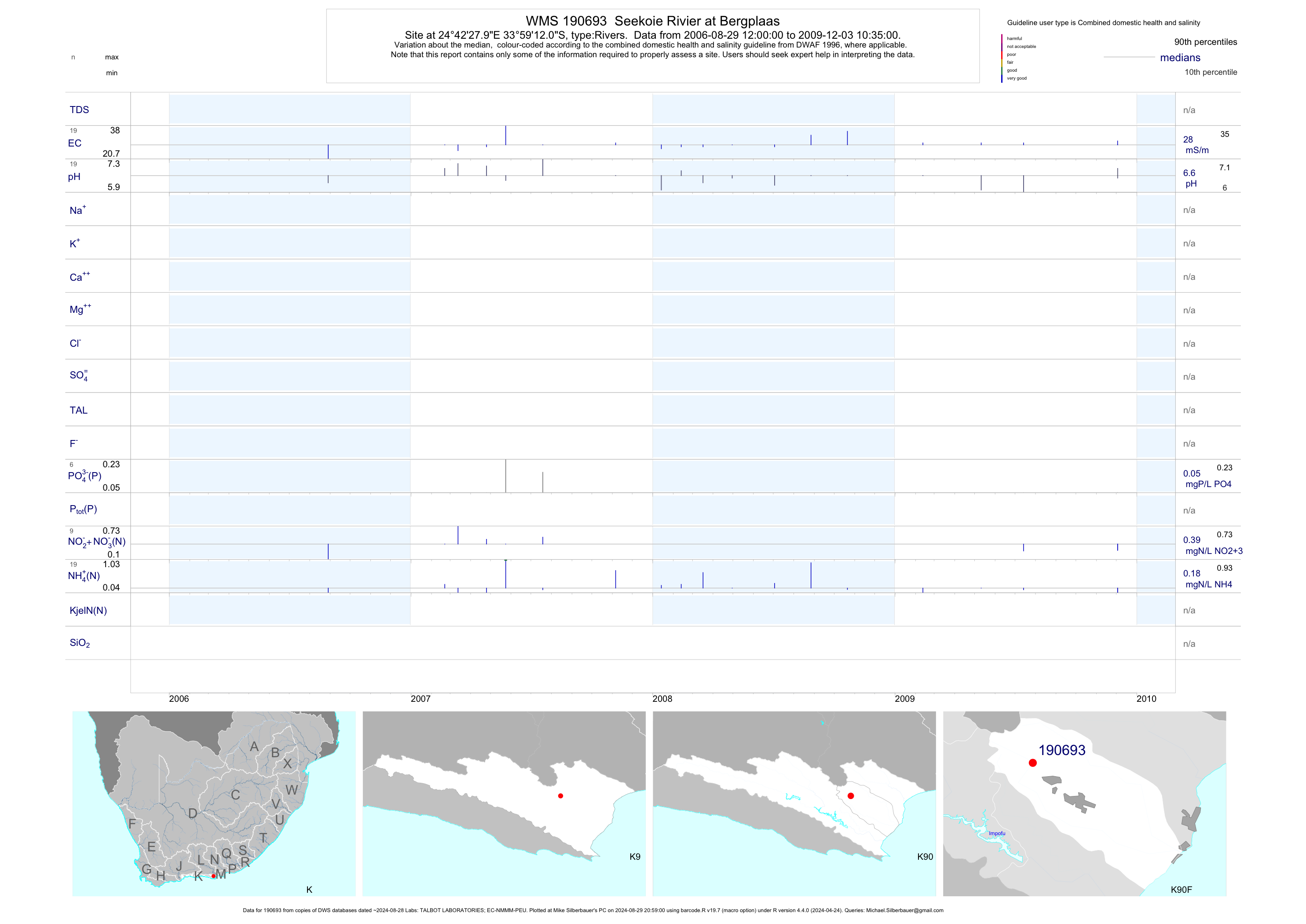
| K90 190693 | plot | data | Seekoie Rivier at Bergplaas | Rivers | 38 | 2006-08-29 | 2009-12-03 | 28 | 190693 | -33.98667 | 24.70778 |
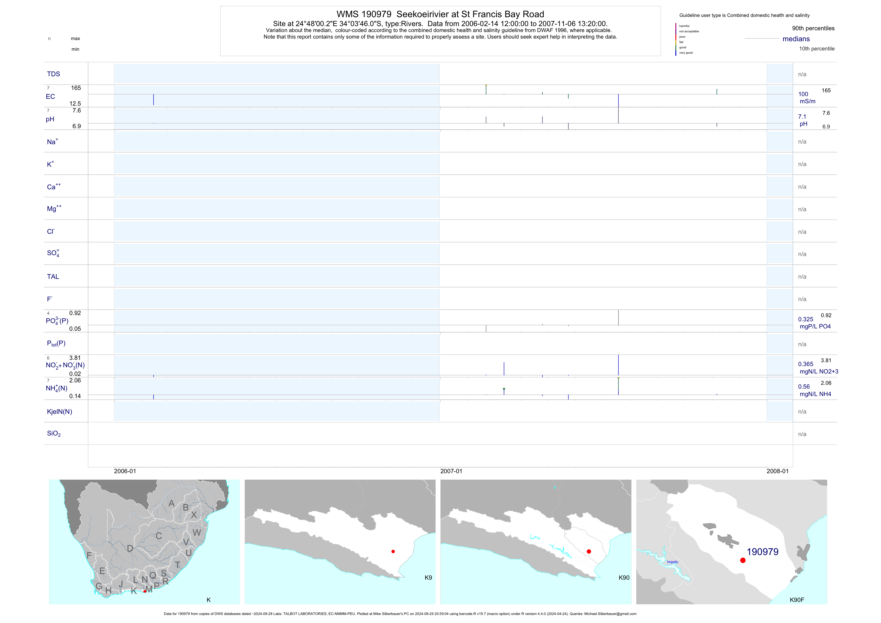
| K90 190979 | plot | data | Seekoeirivier at St Francis Bay Road | Rivers | 13 | 2006-02-14 | 2007-11-06 | 100 | 190979 | -34.06281 | 24.80008 |
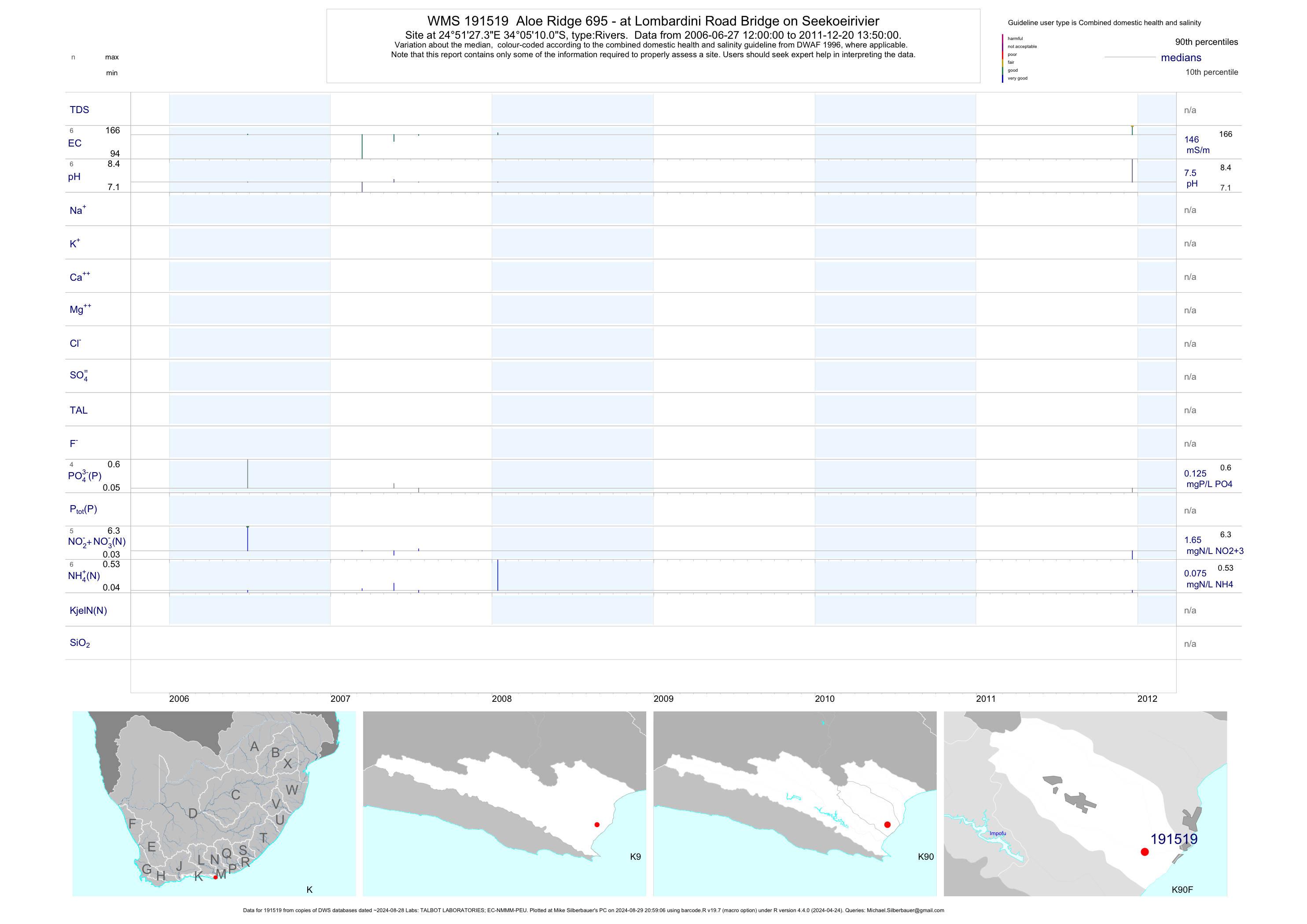
| K90 191519 | plot | data | Aloe Ridge 695 - at Lombardini Road Bridge on Seekoeirivier | Rivers | 12 | 2006-06-27 | 2011-12-20 | 146 | 191519 | -34.08611 | 24.85758 |
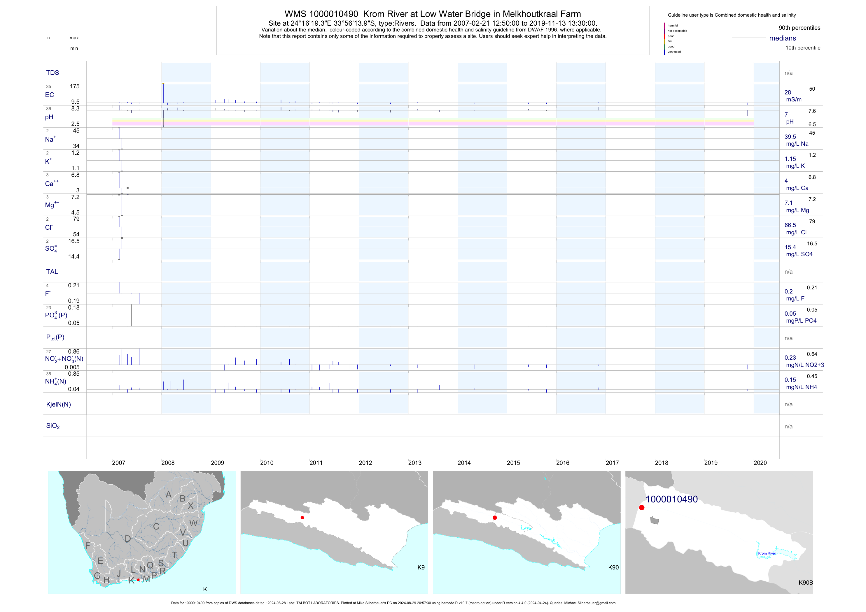
| K90 1000010490 | plot | data | Krom River at Low Water Bridge in Melkhoutkraal Farm | Rivers | 65 | 2007-02-21 | 2016-11-10 | 28 | 1-10490 | -33.93722 | 24.27206 |
| K90 1000010491 | plot | data | Krom River at Low Water Bridge in Assegaibosch Station | Rivers | 95 | 2007-02-21 | 2019-05-14 | 30 | 1-10491 | -33.94457 | 24.31760 |
| K90 1000010492 | plot | data | Below Rondavevels in Assegaibosch Station | Rivers | 94 | 2007-02-21 | 2019-05-14 | 28 | 1-10492 | -33.94728 | 24.32683 |
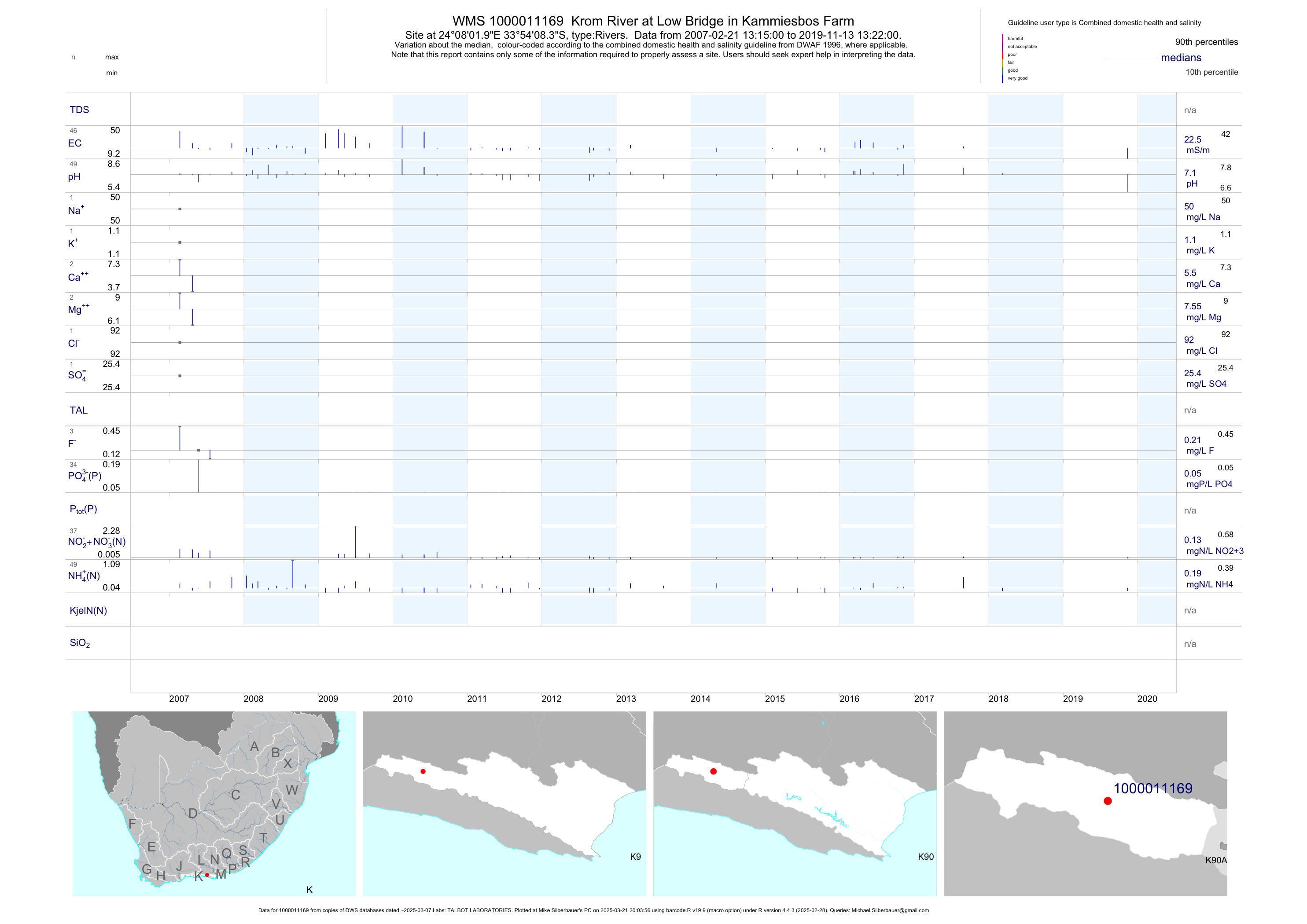
| K90 1000011169 | plot | data | Krom River at Low Bridge in Kammiesbos Farm | Rivers | 97 | 2007-02-21 | 2018-03-09 | 22 | 1-11169 | -33.90233 | 24.13389 |
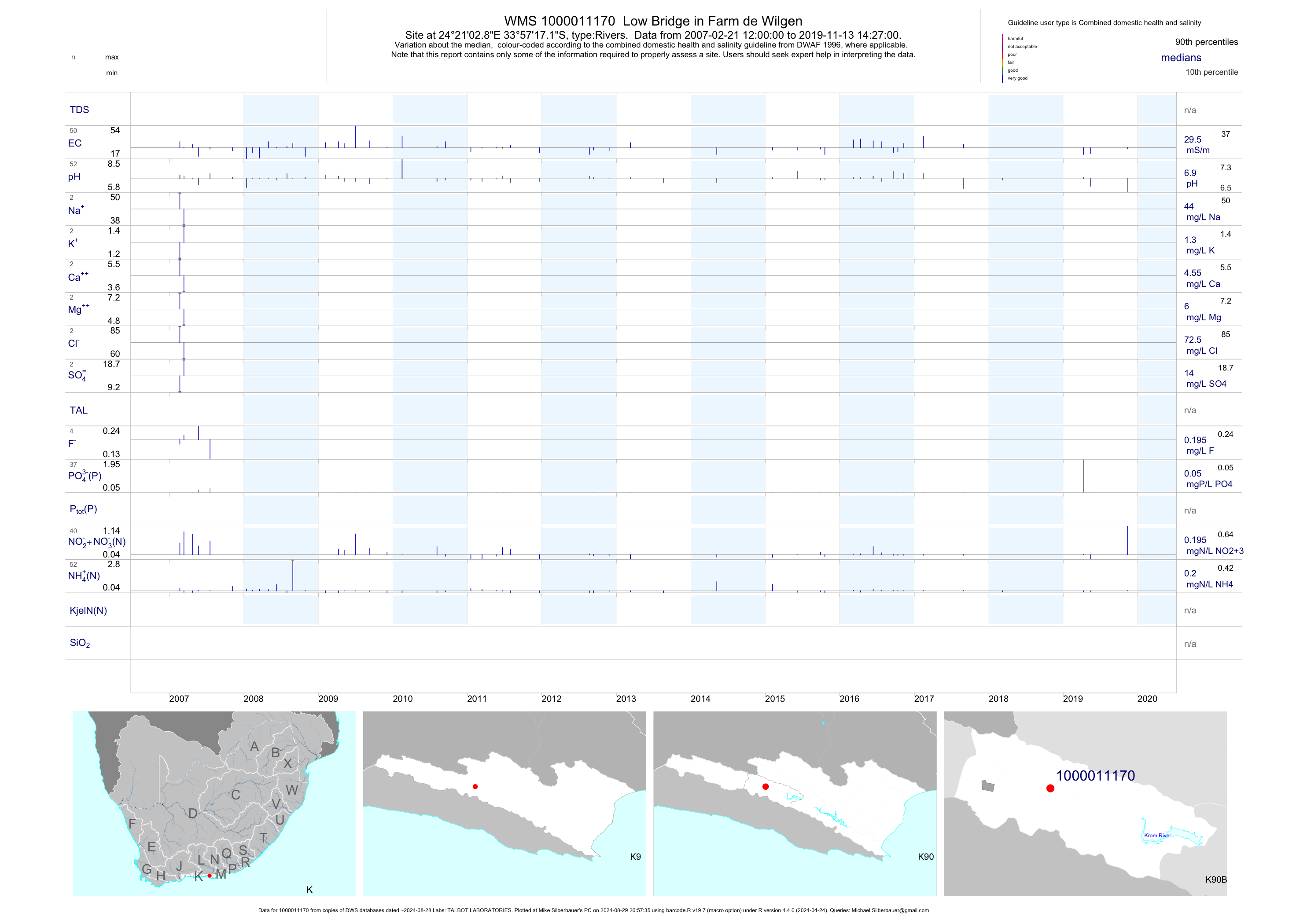
| K90 1000011170 | plot | data | Low Bridge in Farm de Wilgen | Rivers | 102 | 2007-02-21 | 2019-05-14 | 30 | 1-11170 | -33.95475 | 24.35078 |
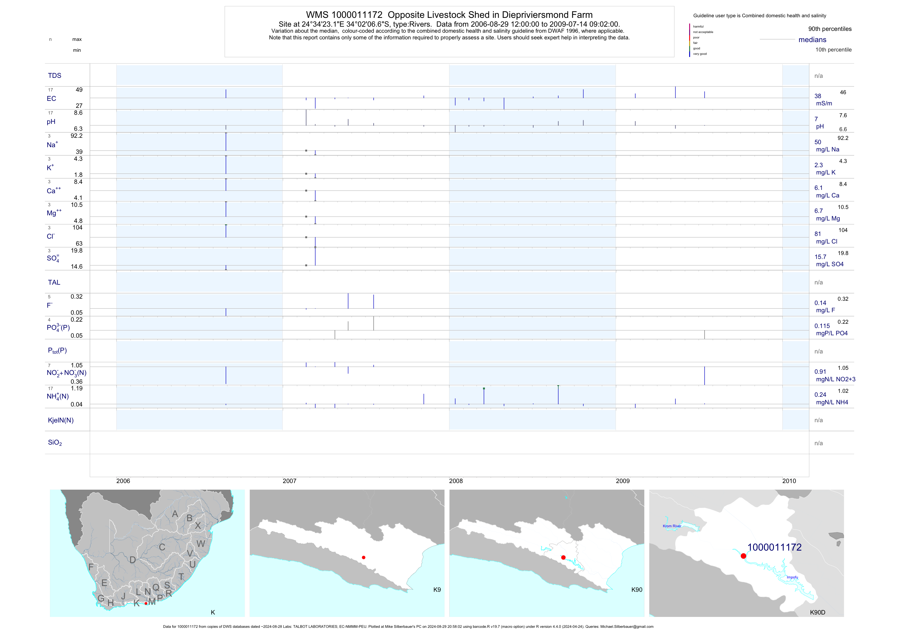
| K90 1000011172 | plot | data | Opposite Livestock Shed in Diepriviersmond Farm | Rivers | 33 | 2006-08-29 | 2015-02-05 | 38 | 1-11172 | -34.03517 | 24.57308 |
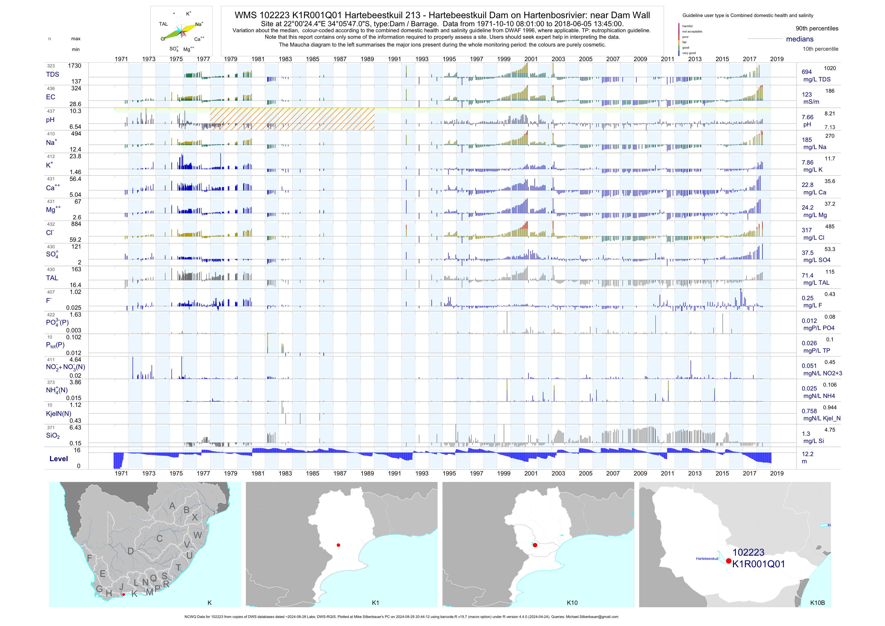
| K10 102223 | plot | data | Hartebeestkuil 213 - Hartebeestkuil Dam on Hartenbosrivier: near Dam Wall (NCWQ) Q01 | Dam / Barrage | 437 | 1971-10-10 | 2018-06-05 | 123 | K1R001 | -34.09640 | 22.00680 |
| K10 102224 | plot | data | Hartebeestkuil Dam on Hartenbos River: Point in D Q02 | Dam / Barrage | 13 | 1971-10-10 | 1972-12-06 | 96 | K1R001 | -34.09583 | 22.00750 |
| K10 102225 | plot | data | Hartebeestkuil Dam on Hartenbos River: Point in D Q03 | Dam / Barrage | 13 | 1971-10-10 | 1972-12-06 | 96 | K1R001 | -34.09583 | 22.00750 |
| K10 102226 | plot | data | Hartebeestkuil Dam on Hartenbos River: Point in D Q04 | Dam / Barrage | 13 | 1971-10-10 | 1972-12-06 | 90 | K1R001 | -34.09583 | 22.00750 |
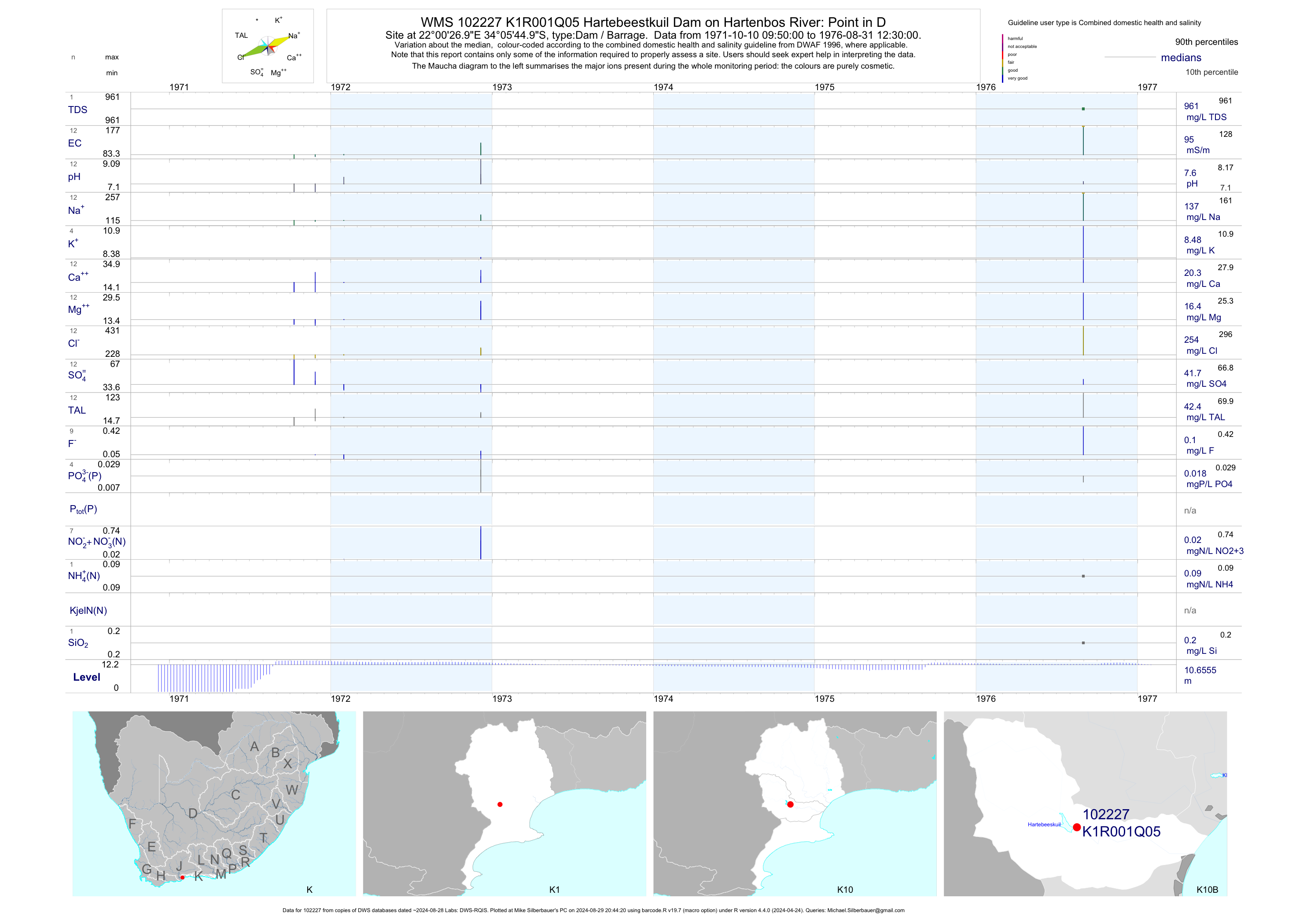
| K10 102227 | plot | data | Hartebeestkuil Dam on Hartenbos River: Point in D Q05 | Dam / Barrage | 12 | 1971-10-10 | 1976-08-31 | 95 | K1R001 | -34.09583 | 22.00750 |
| K10 102228 | plot | data | Hartebeestkuil Dam on Hartenbos River: Point in D Q06 | Dam / Barrage | 12 | 1971-10-10 | 1972-12-06 | 92 | K1R001 | -34.09583 | 22.00750 |
| K10 102229 | plot | data | Hartebeestkuil Dam on Hartenbos River: Point in D Q07 | Dam / Barrage | 12 | 1971-10-10 | 1972-12-06 | 92 | K1R001 | -34.09583 | 22.00750 |
| K10 102230 | plot | data | Hartebeestkuil Dam on Hartenbos River: Point in D Q08 | Dam / Barrage | 8 | 1971-10-10 | 1972-12-06 | 94 | K1R001 | -34.09583 | 22.00750 |
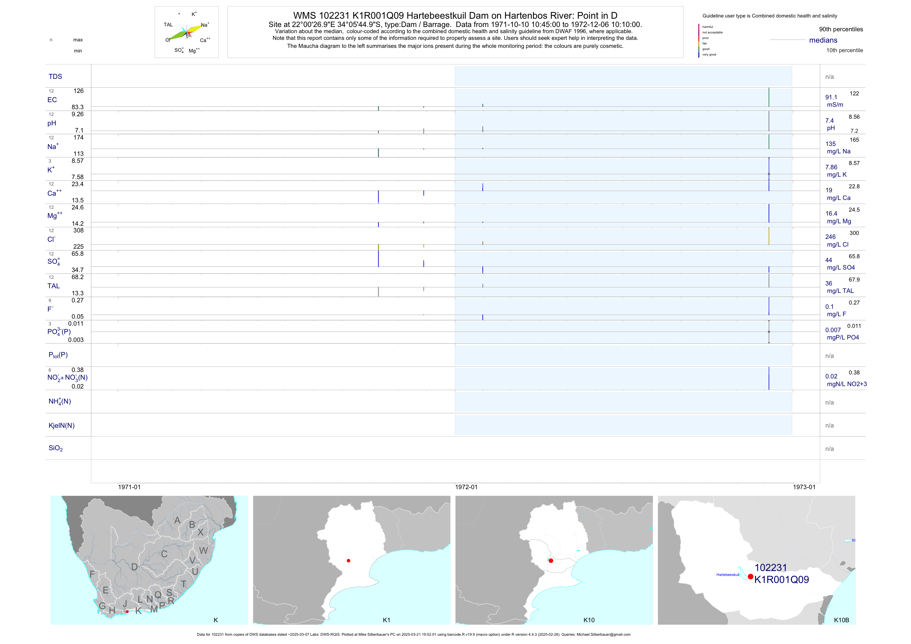
| K10 102231 | plot | data | Hartebeestkuil Dam on Hartenbos River: Point in D Q09 | Dam / Barrage | 12 | 1971-10-10 | 1972-12-06 | 91 | K1R001 | -34.09583 | 22.00750 |
| K10 102232 | plot | data | Hartebeestkuil Dam on Hartenbos River: Point in D Q10 | Dam / Barrage | 12 | 1971-10-10 | 1972-12-06 | 94 | K1R001 | -34.09583 | 22.00750 |
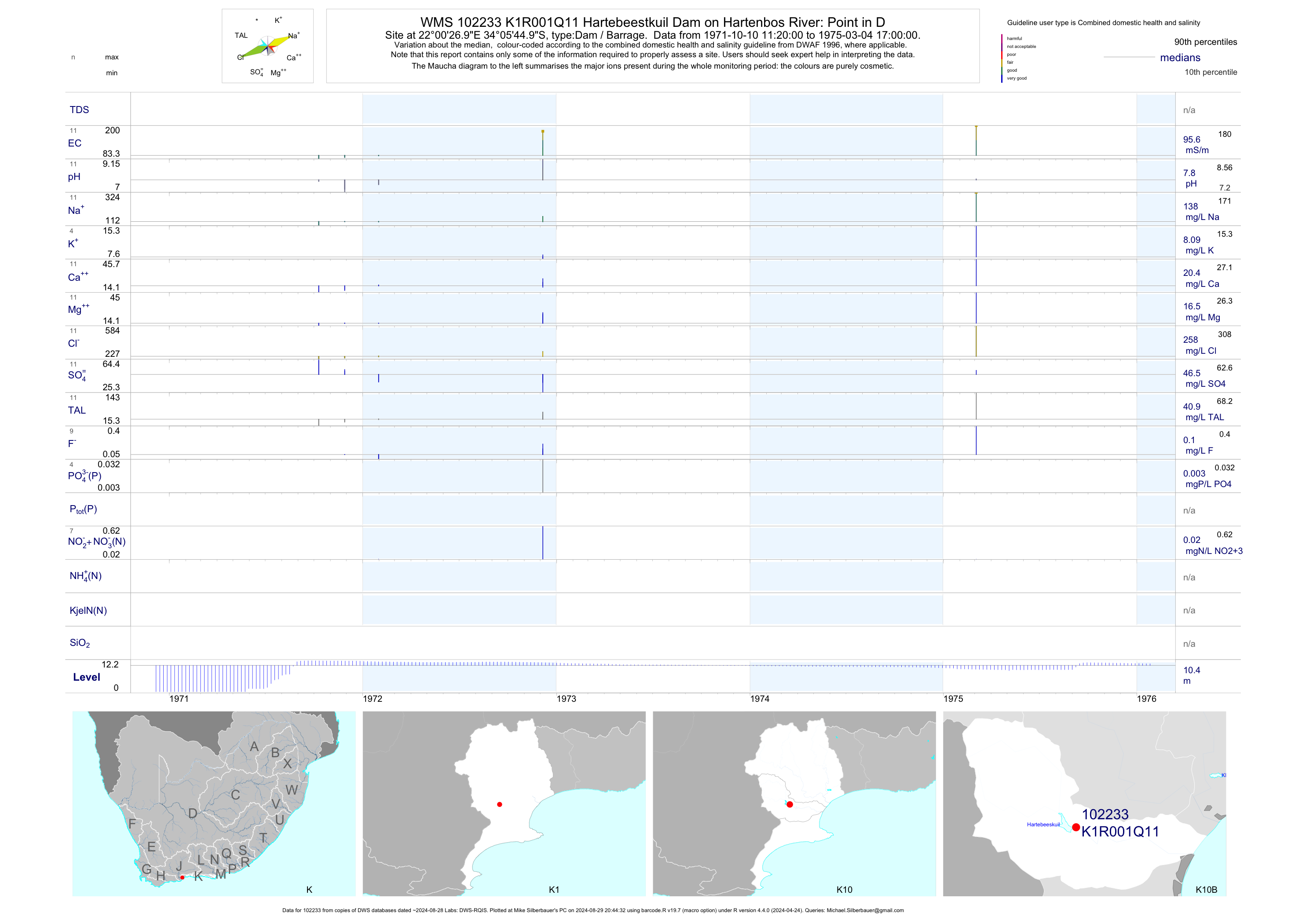
| K10 102233 | plot | data | Hartebeestkuil Dam on Hartenbos River: Point in D Q11 | Dam / Barrage | 11 | 1971-10-10 | 1975-03-04 | 96 | K1R001 | -34.09583 | 22.00750 |
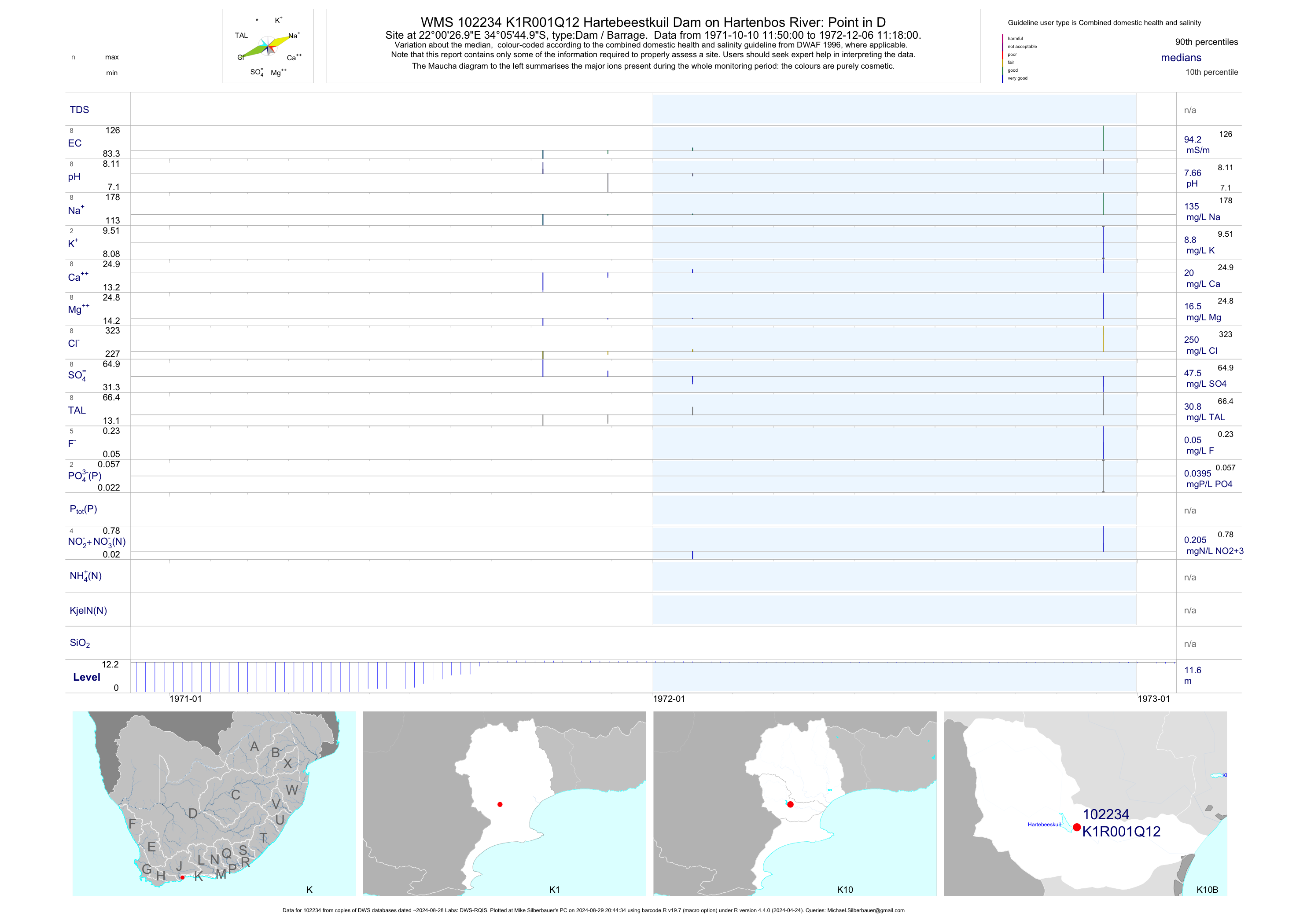
| K10 102234 | plot | data | Hartebeestkuil Dam on Hartenbos River: Point in D Q12 | Dam / Barrage | 8 | 1971-10-10 | 1972-12-06 | 94 | K1R001 | -34.09583 | 22.00750 |
| K10 102235 | plot | data | Hartebeestkuil Dam on Hartenbos River: Point in D Q13 | Dam / Barrage | 9 | 1971-10-10 | 1972-12-06 | 97 | K1R001 | -34.09583 | 22.00750 |
| K10 102236 | plot | data | Hartebeestkuil Dam on Hartenbos River: Point in D Q14 | Dam / Barrage | 9 | 1971-10-10 | 1972-12-06 | 97 | K1R001 | -34.09583 | 22.00750 |
| K10 102237 | plot | data | Hartebeestkuil Dam on Hartenbos River: Point in D Q15 | Dam / Barrage | 9 | 1971-10-10 | 1972-12-06 | 97 | K1R001 | -34.09583 | 22.00750 |
| K10 102238 | plot | data | Hartebeestkuil Dam on Hartenbos River: Point in D Q16 | Dam / Barrage | 8 | 1971-10-10 | 1972-12-06 | 93 | K1R001 | -34.09583 | 22.00750 |
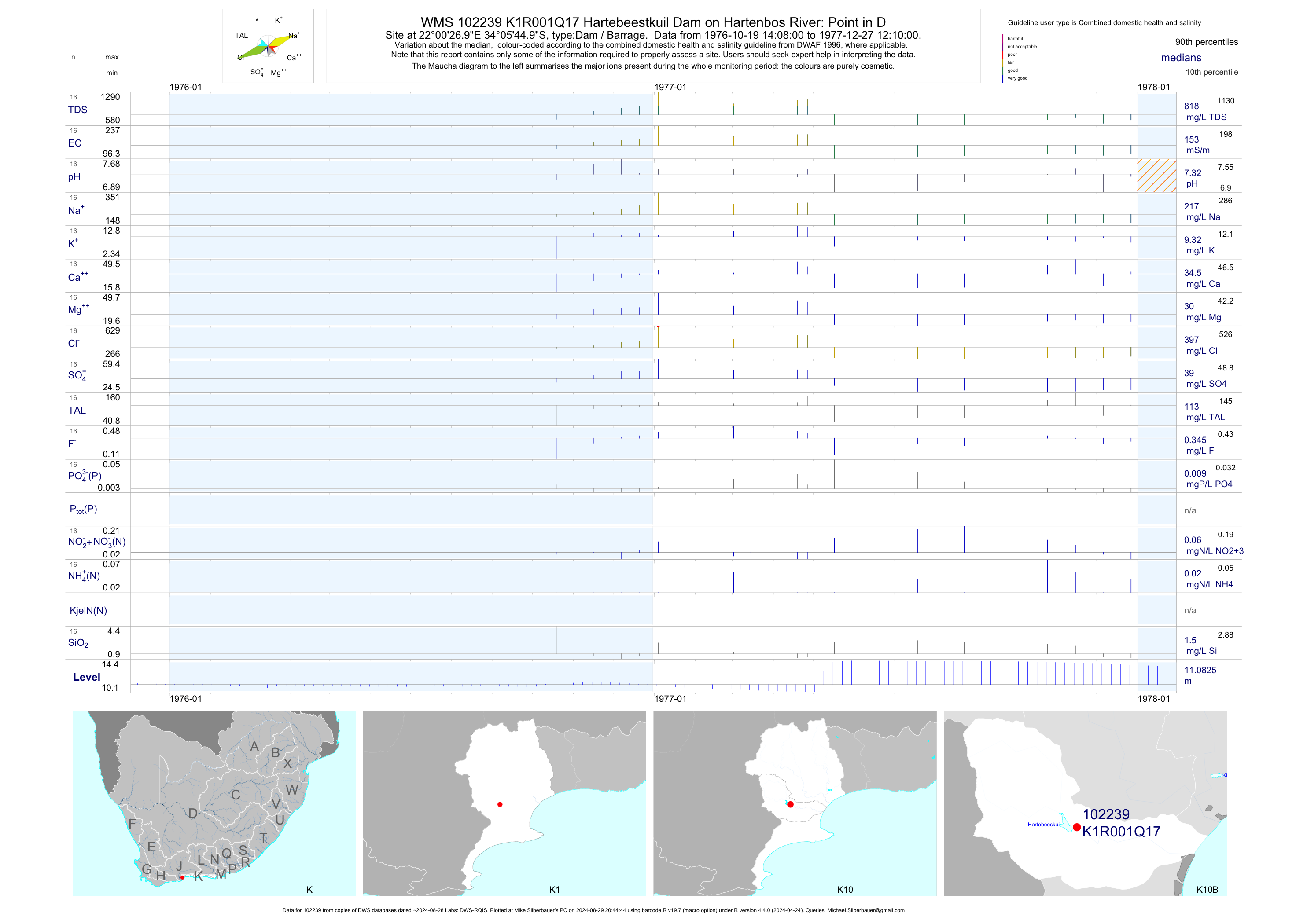
| K10 102239 | plot | data | Hartebeestkuil Dam on Hartenbos River: Point in D Q17 | Dam / Barrage | 16 | 1976-10-19 | 1977-12-27 | 153 | K1R001 | -34.09583 | 22.00750 |
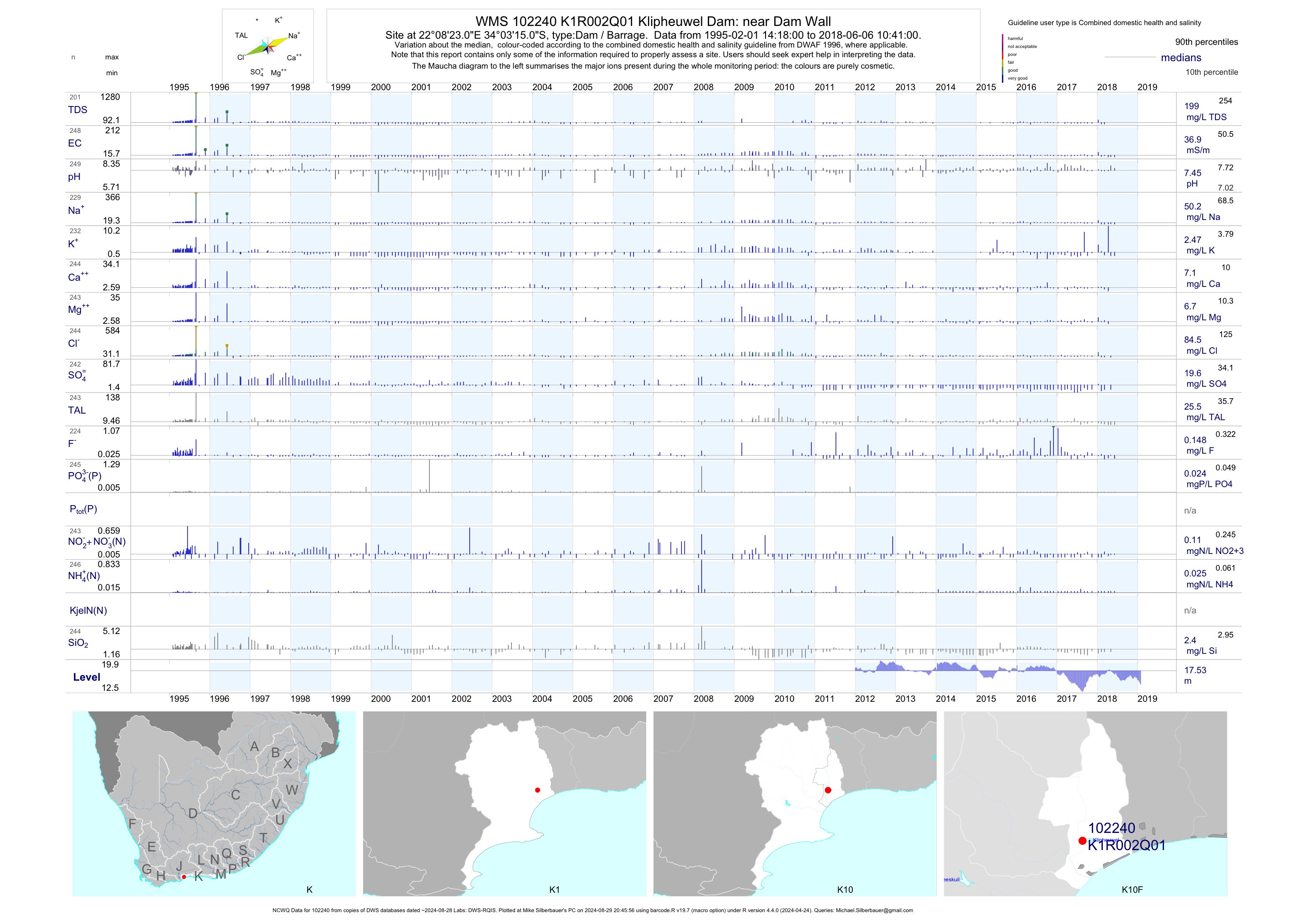
| K10 102240 | plot | data | Klipheuwel Dam: near Dam Wall (NCWQ) Q01 | Dam / Barrage | 249 | 1995-02-01 | 2018-06-06 | 37 | K1R002 | -34.05417 | 22.13972 |
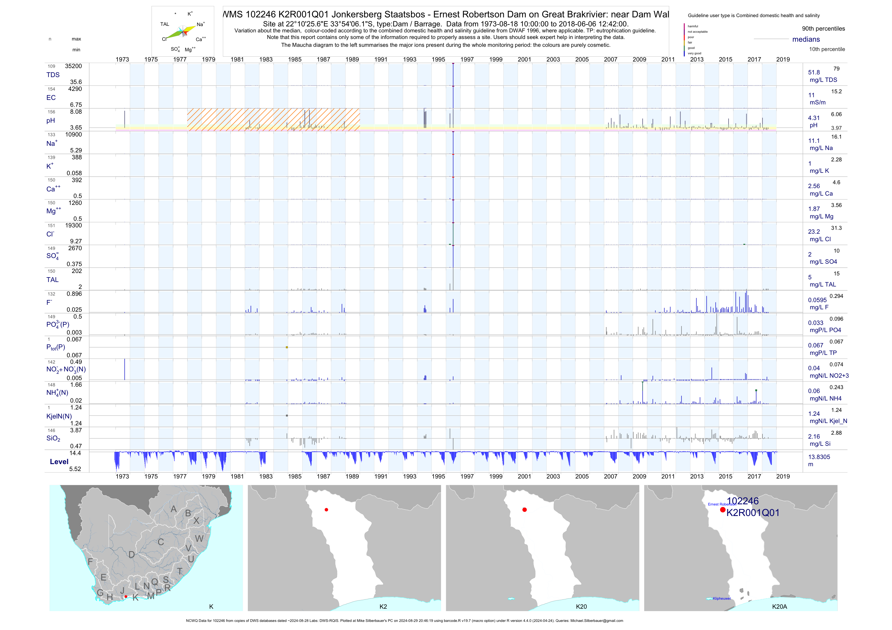
| K20 102246 | plot | data | Jonkersberg Staatsbos - Ernest Robertson Dam on Great Brakrivier: near Dam Wall (NCWQ) Q01 | Dam / Barrage | 156 | 1973-08-18 | 2018-06-06 | 11 | K2R001 | -33.90170 | 22.17380 |
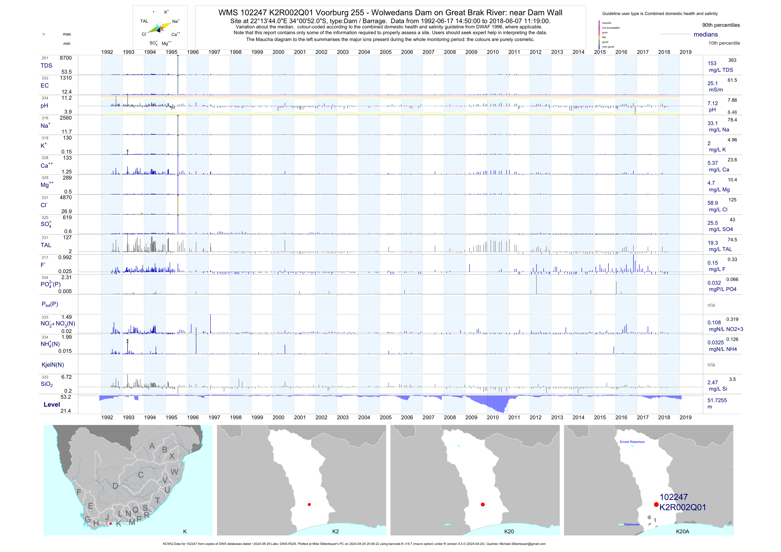
| K20 102247 | plot | data | Voorburg 255 - Wolwedans Dam on Great Brak River: near Dam Wall (NCWQ) Q01 | Dam / Barrage | 334 | 1992-06-17 | 2018-06-07 | 25 | K2R002 | -34.01444 | 22.22889 |
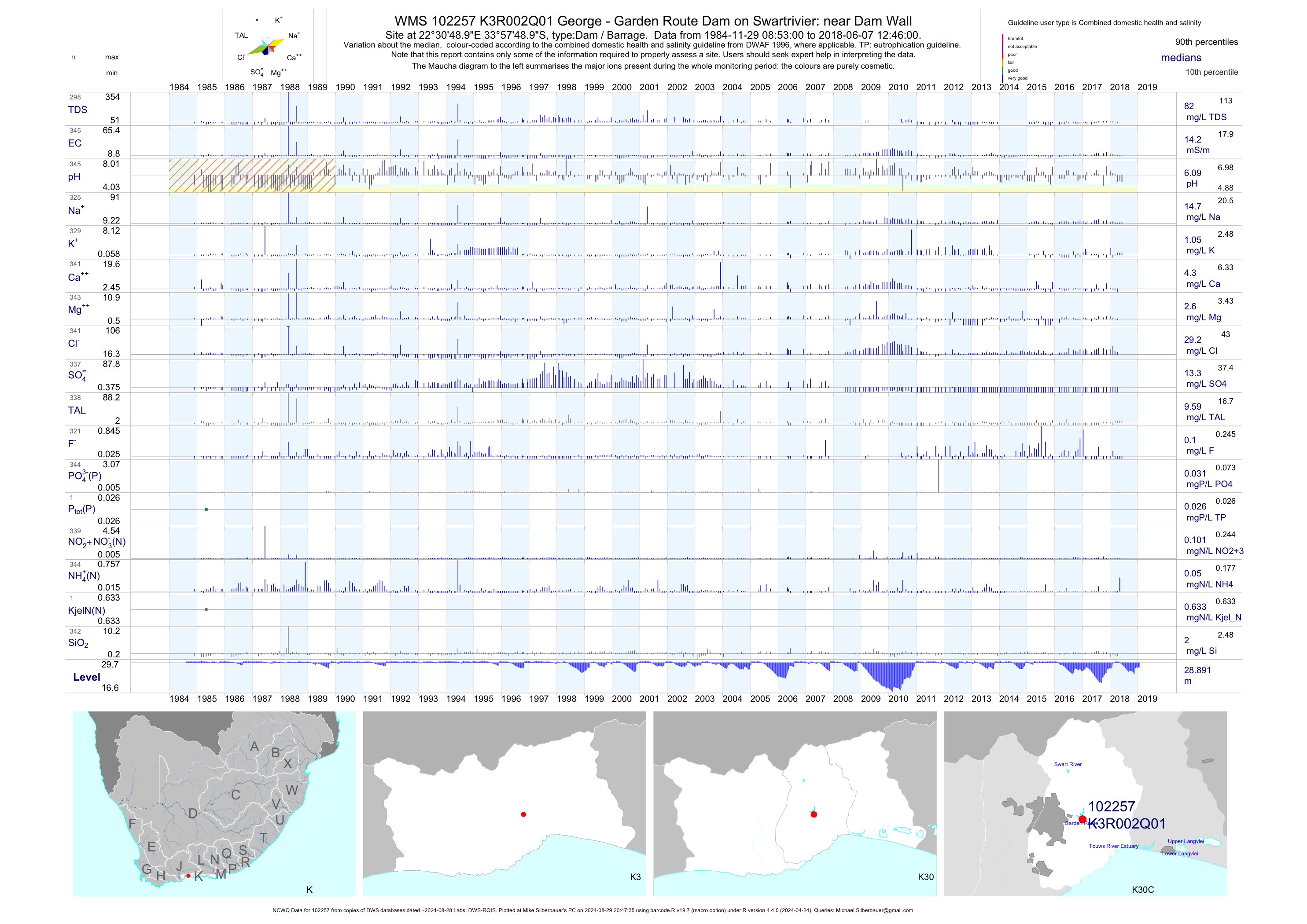
| K30 102257 | plot | data | George - Garden Route Dam on Swartrivier: near Dam Wall (NCWQ) Q01 | Dam / Barrage | 346 | 1984-11-29 | 2018-06-07 | 14 | K3R002 | -33.96360 | 22.51360 |
| K30 102258 | plot | data | Ronde Vlei at Ronde Valley (NCWQ) Q01 | Lake | 492 | 1977-12-01 | 2018-07-06 | 1490 | K3R003 | -33.99333 | 22.71667 |
| K30 102259 | plot | data | Rondevlei (Eastern Section) at Ronde Valley Q02 | Lake | 49 | 1998-02-03 | 1999-01-15 | 1460 | K3R003 | -33.99333 | 22.71667 |
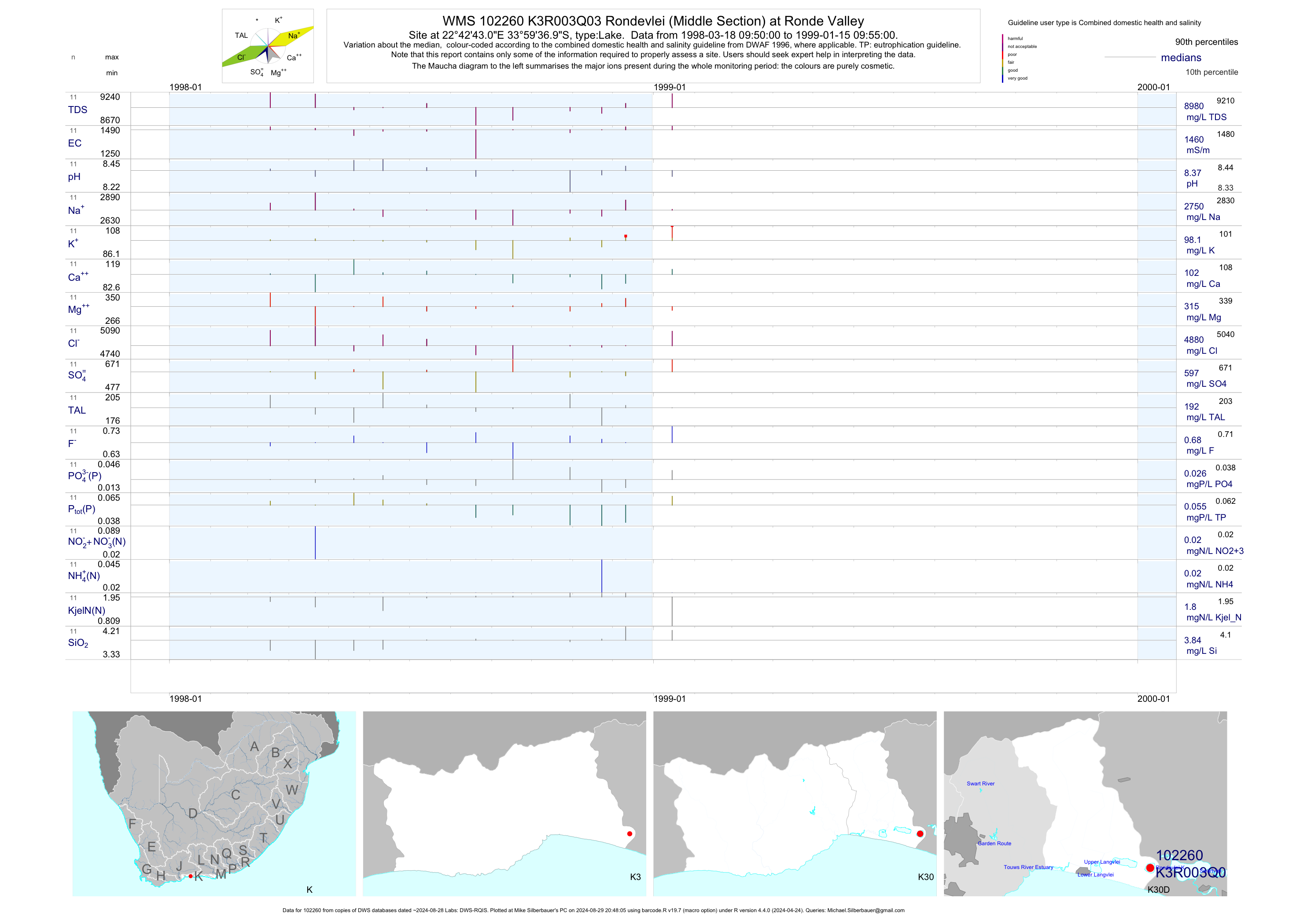
| K30 102260 | plot | data | Rondevlei (Middle Section) at Ronde Valley Q03 | Lake | 22 | 1998-03-18 | 1999-01-15 | 1460 | K3R003 | -33.99361 | 22.71194 |
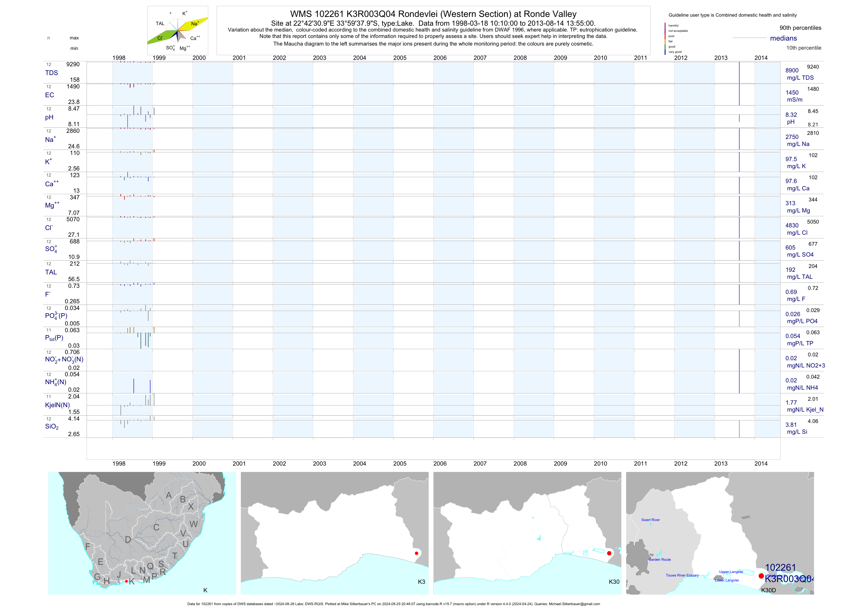
| K30 102261 | plot | data | Rondevlei (Western Section) at Ronde Valley Q04 | Lake | 22 | 1998-03-18 | 2013-08-14 | 1450 | K3R003 | -33.99389 | 22.70861 |
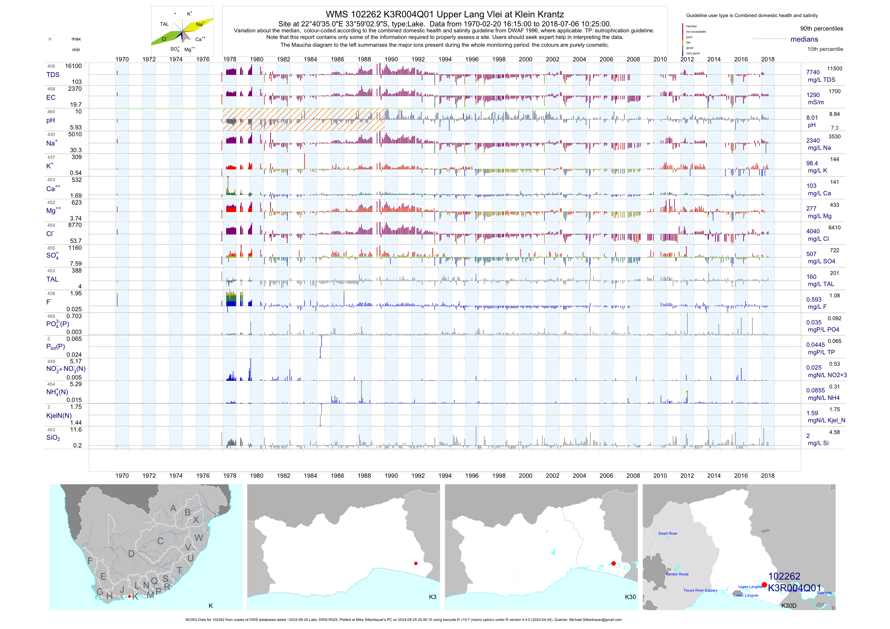
| K30 102262 | plot | data | Upper Lang Vlei at Klein Krantz (NCWQ) Q01 | Lake | 759 | 1970-02-20 | 2018-07-06 | 1286 | K3R004 | -33.98417 | 22.67639 |
| K30 102263 | plot | data | Bo-Langvlei (Eastern Section) at Klein Krantz/Wil Q02 | Lake | 49 | 1998-02-08 | 1999-01-13 | 960 | K3R004 | -33.99083 | 22.69083 |
| K30 102264 | plot | data | Bo-Langvlei (Middle Section) at Klein Krantz/Wild Q03 | Lake | 23 | 1998-03-18 | 1999-01-13 | 939 | K3R004 | -33.98861 | 22.68167 |
| K30 102265 | plot | data | Bo-Langvlei (Western Section) at Klein Krantz/Wil Q04 | Lake | 21 | 1998-03-18 | 1999-01-15 | 932 | K3R004 | -33.98639 | 22.67083 |
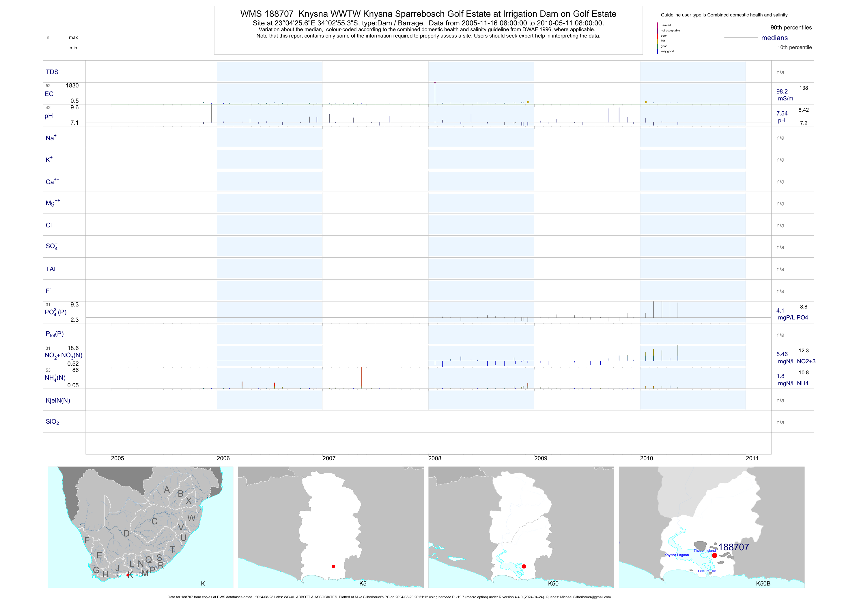
| K50 188707 | plot | data | Knysna WWTW Knysna Sparrebosch Golf Estate at Irrigation Dam on Golf Estate | Dam / Barrage | 146 | 2001-01-31 | 2010-05-11 | 95 | 188707 | -34.04870 | 23.07380 |
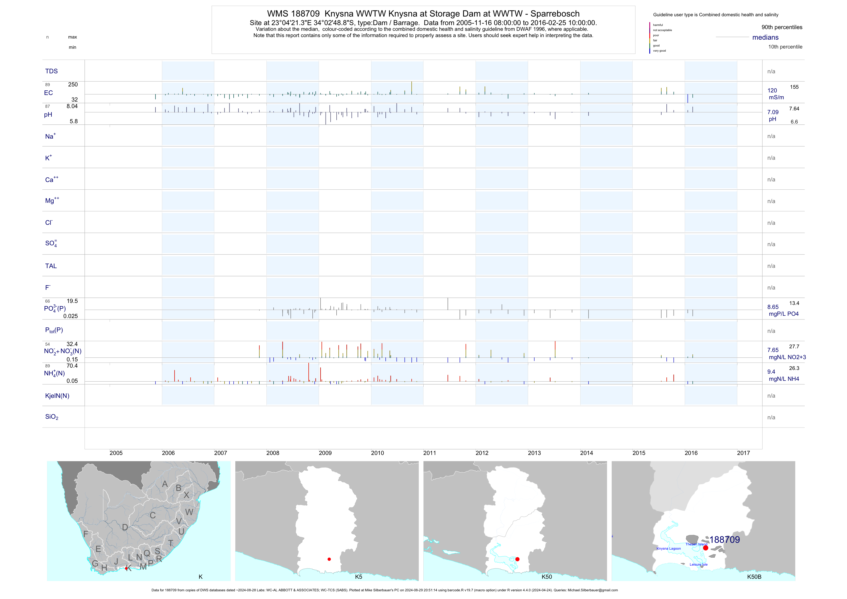
| K50 188709 | plot | data | Knysna WWTW Knysna at Storage Dam at WWTW - Sparrebosch | Dam / Barrage | 171 | 2001-11-13 | 2016-02-25 | 119 | 188709 | -34.04690 | 23.07260 |
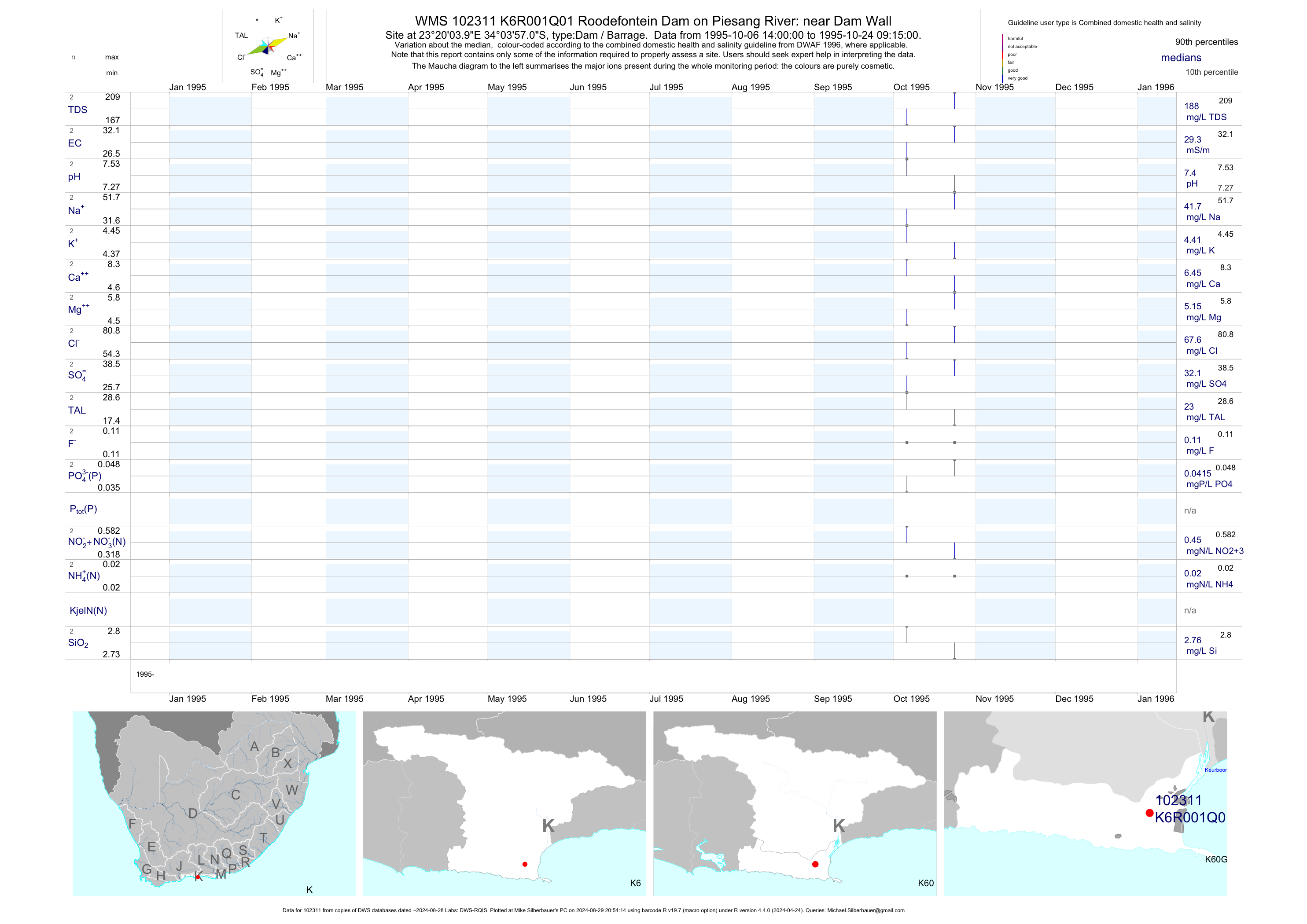
| K60 102311 | plot | data | Roodefontein Dam on Piesang River: near Dam Wall Q01 | Dam / Barrage | 2 | 1995-10-06 | 1995-10-24 | 29 | K6R001 | -34.06583 | 23.33444 |
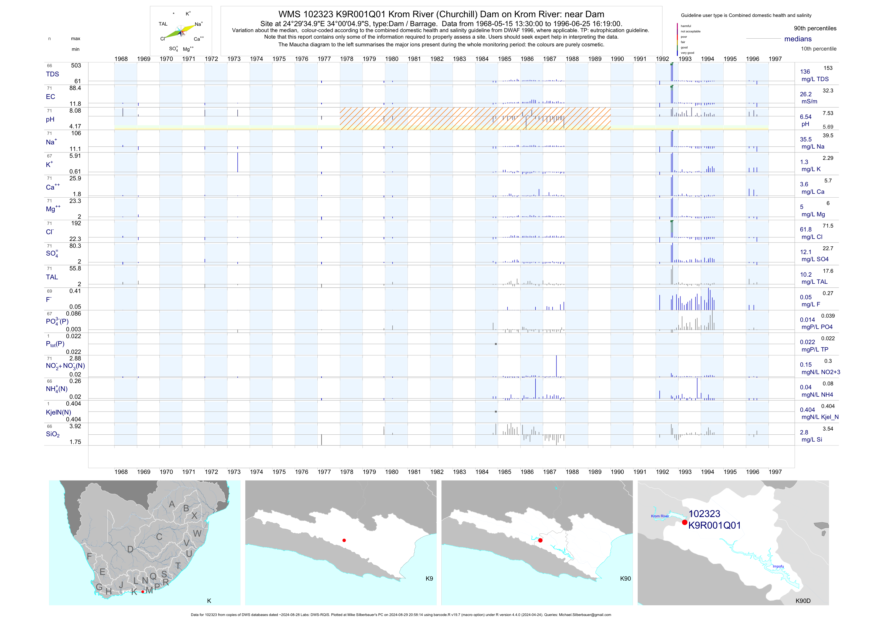
| K90 102323 | plot | data | Krom River (Churchill) Dam on Krom River: near Dam Q01 | Dam / Barrage | 71 | 1968-05-15 | 1996-06-25 | 26 | K9R001 | -34.00139 | 24.49306 |
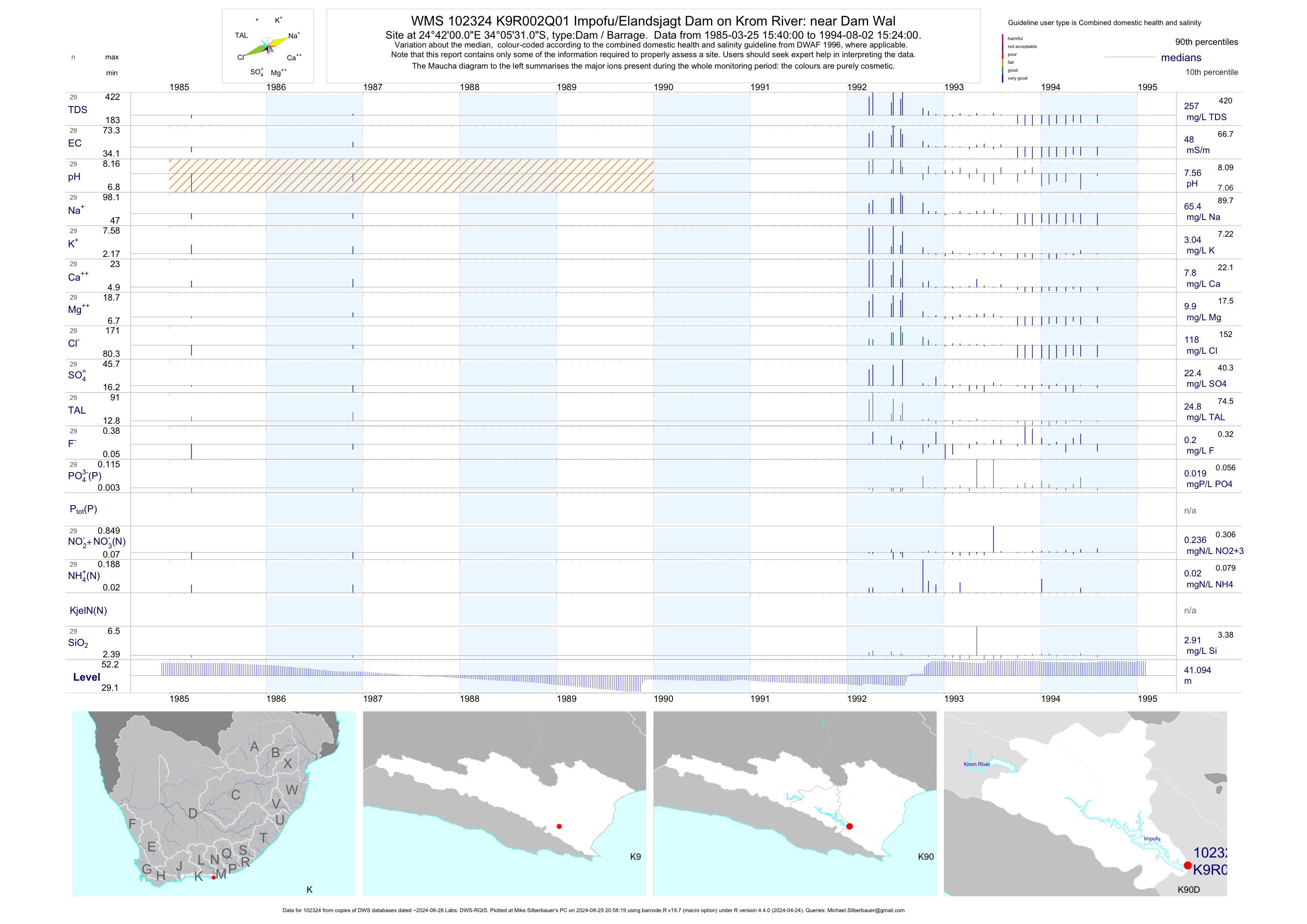
| K90 102324 | plot | data | Impofu/Elandsjagt Dam on Krom River: near Dam Wal Q01 | Dam / Barrage | 29 | 1985-03-25 | 1994-08-02 | 48 | K9R002 | -34.09194 | 24.70000 |
| K10 1000012932 | plot | data | Knysna - GZ00106 | Spring/Eye | 2 | 2005-08-10 | 2005-08-10 | 42 | 11 | -34.04664 | 22.10128 |
| K10 1000012450 | plot | data | Hartebeest Kraal - GZ00047 | Spring/Eye | 2 | 2005-08-12 | 2005-08-12 | 192 | 1-12450 | -34.00561 | 22.08097 |
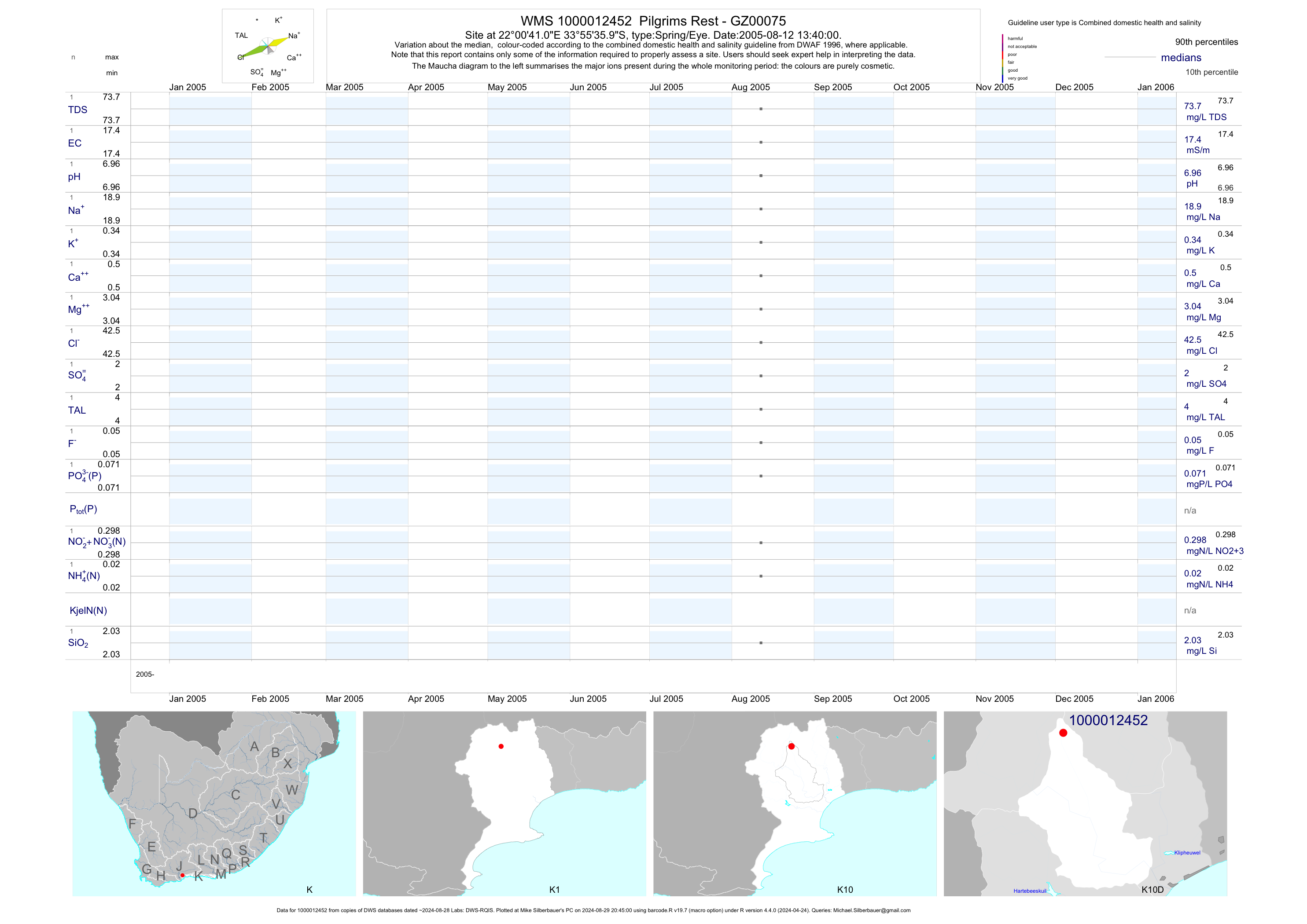
| K10 1000012452 | plot | data | Pilgrims Rest - GZ00075 | Spring/Eye | 2 | 2005-08-12 | 2005-08-12 | 17 | 1-12452 | -33.92664 | 22.01139 |
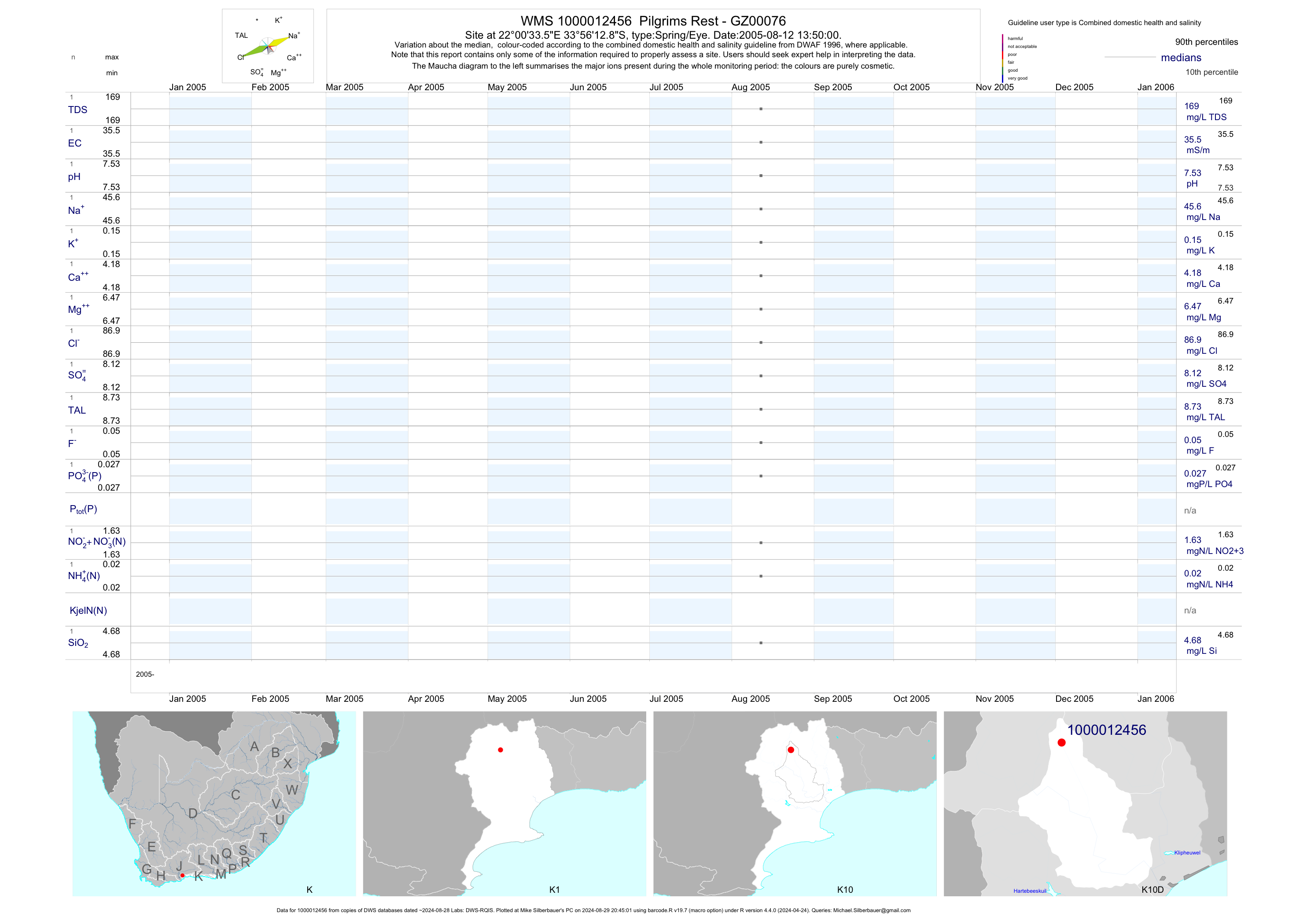
| K10 1000012456 | plot | data | Pilgrims Rest - GZ00076 | Spring/Eye | 2 | 2005-08-12 | 2005-08-12 | 36 | 1-12456 | -33.93689 | 22.00931 |
| K10 1000012458 | plot | data | Farm - GZ00077 | Spring/Eye | 2 | 2005-08-15 | 2005-08-15 | 47 | 1-12458 | -33.95069 | 22.15681 |
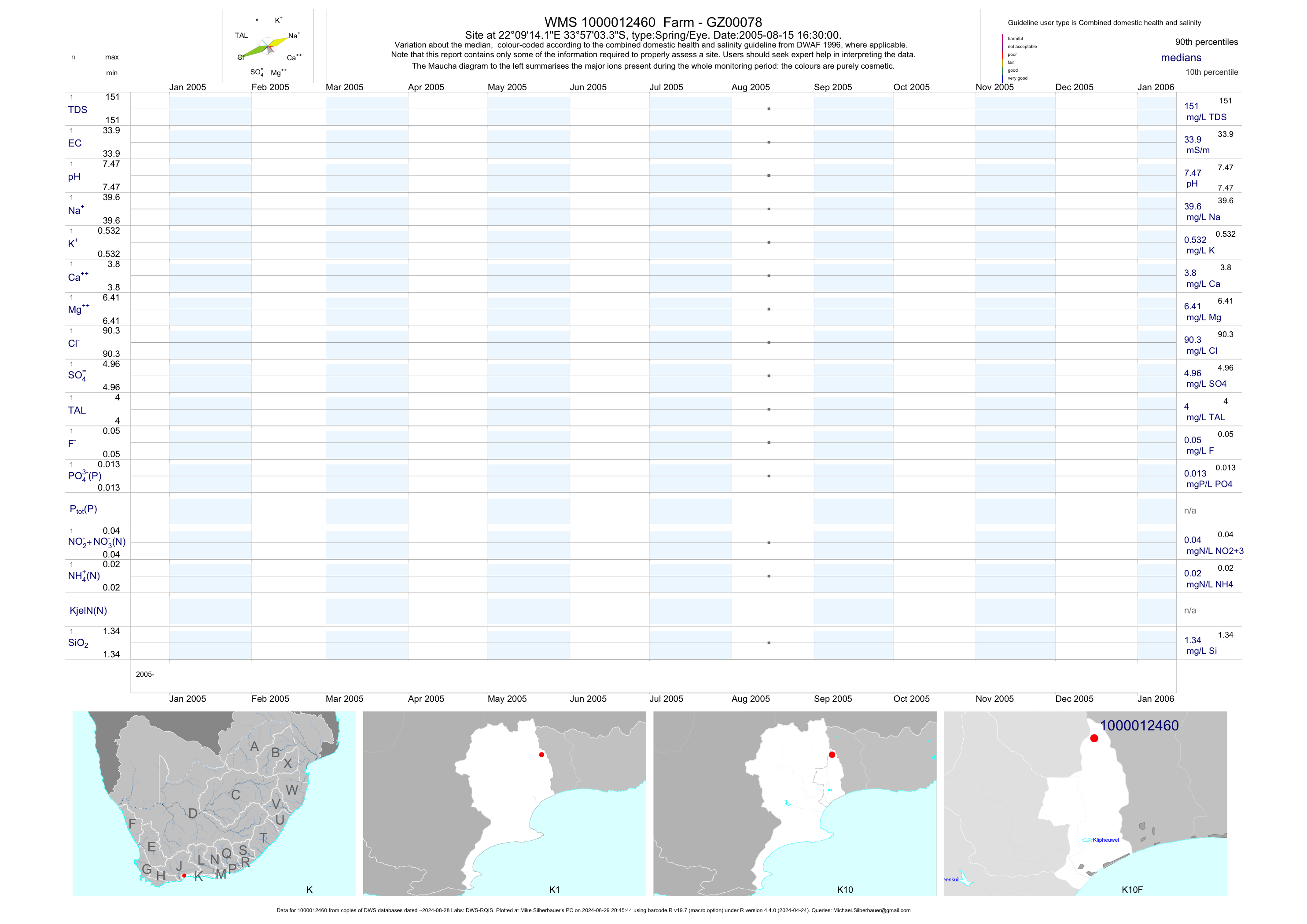
| K10 1000012460 | plot | data | Farm - GZ00078 | Spring/Eye | 2 | 2005-08-15 | 2005-08-15 | 34 | 1-12460 | -33.95092 | 22.15394 |
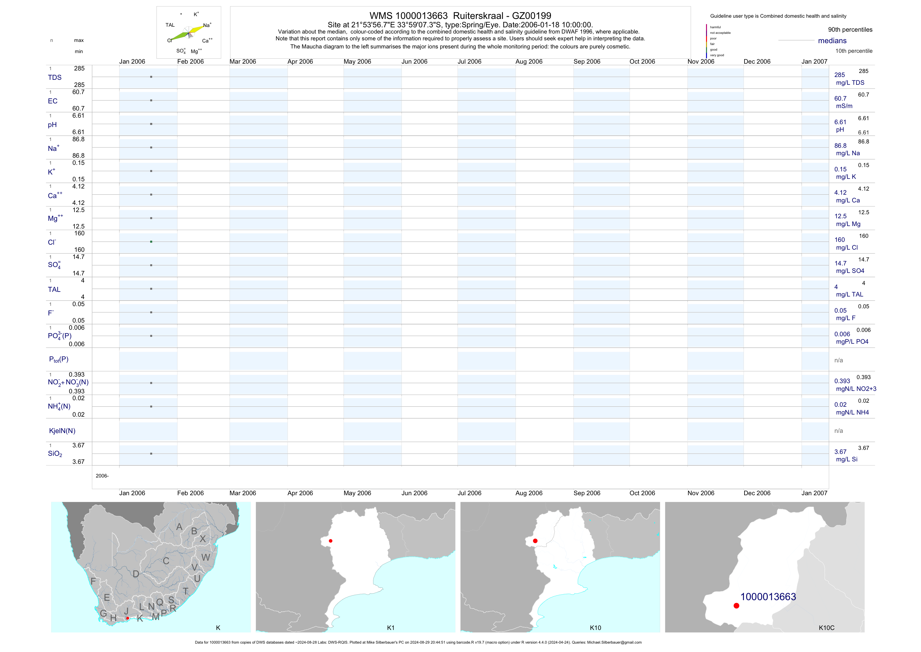
| K10 1000013663 | plot | data | Ruiterskraal - GZ00199 | Spring/Eye | 2 | 2006-01-18 | 2006-01-18 | 61 | 1-13663 | -33.98536 | 21.89911 |
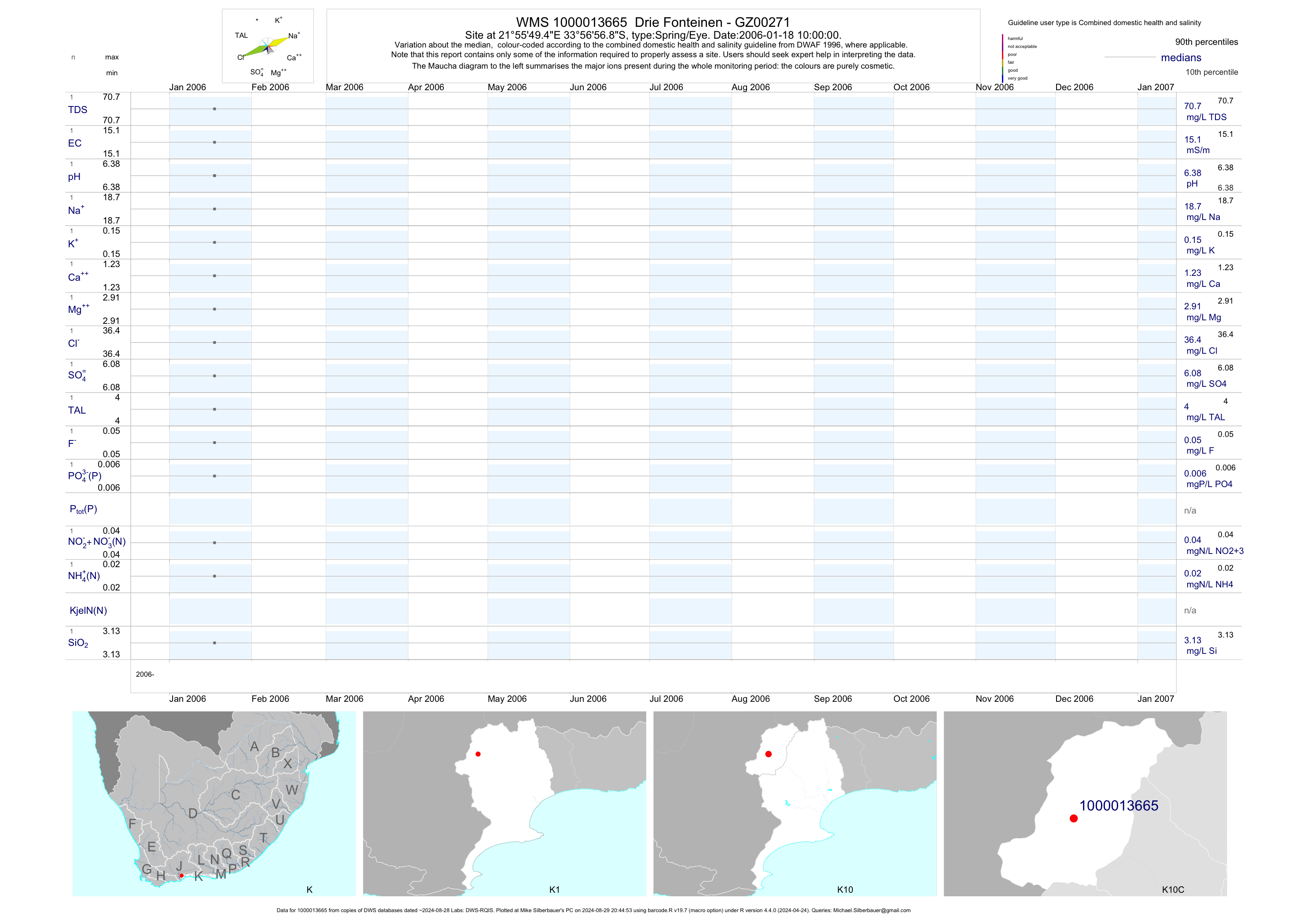
| K10 1000013665 | plot | data | Drie Fonteinen - GZ00271 | Spring/Eye | 2 | 2006-01-18 | 2006-01-18 | 15 | 1-13665 | -33.94911 | 21.93042 |
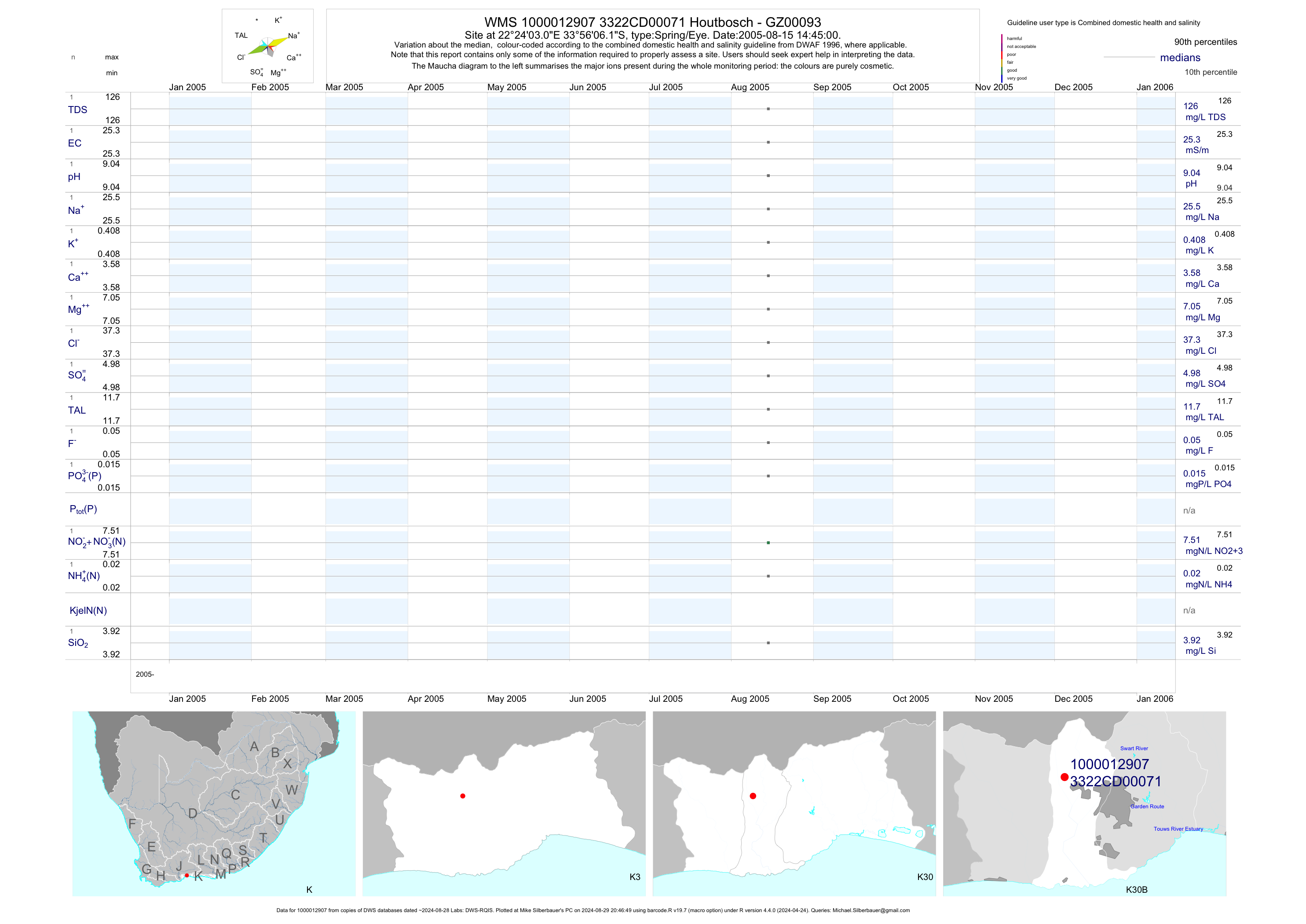
| K30 1000012907 | plot | data | Houtbosch - GZ00093 | Spring/Eye | 2 | 2005-08-10 | 2005-08-15 | 25 | 71 | -33.93505 | 22.40085 |
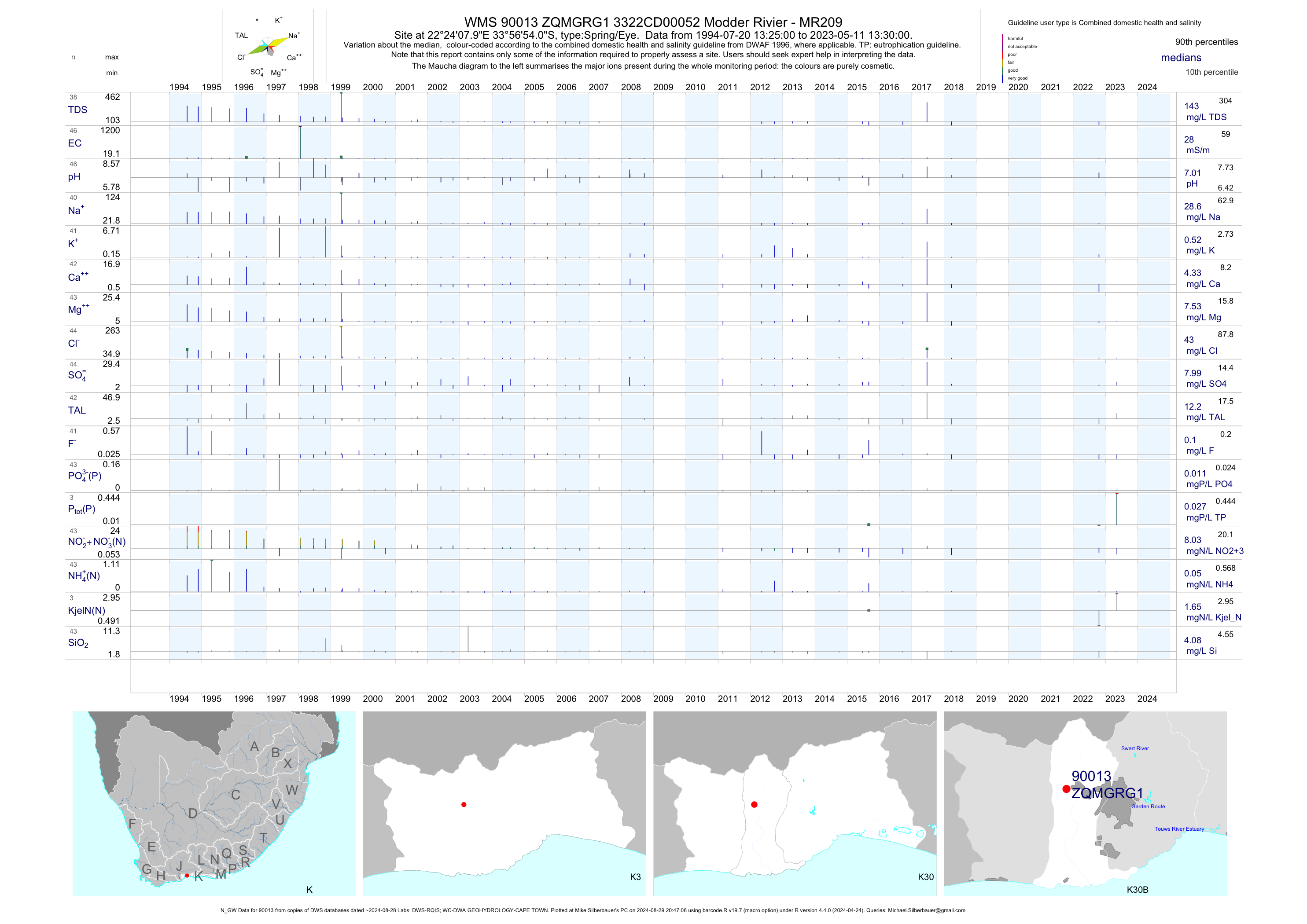
| K30 90013 | plot | data | 3322CD00052 Modder Rivier - MR209 (N_GW) | Spring/Eye | 49 | 1994-07-20 | 2018-03-27 | 30 | ZQMGRG1 | -33.94833 | 22.40222 |
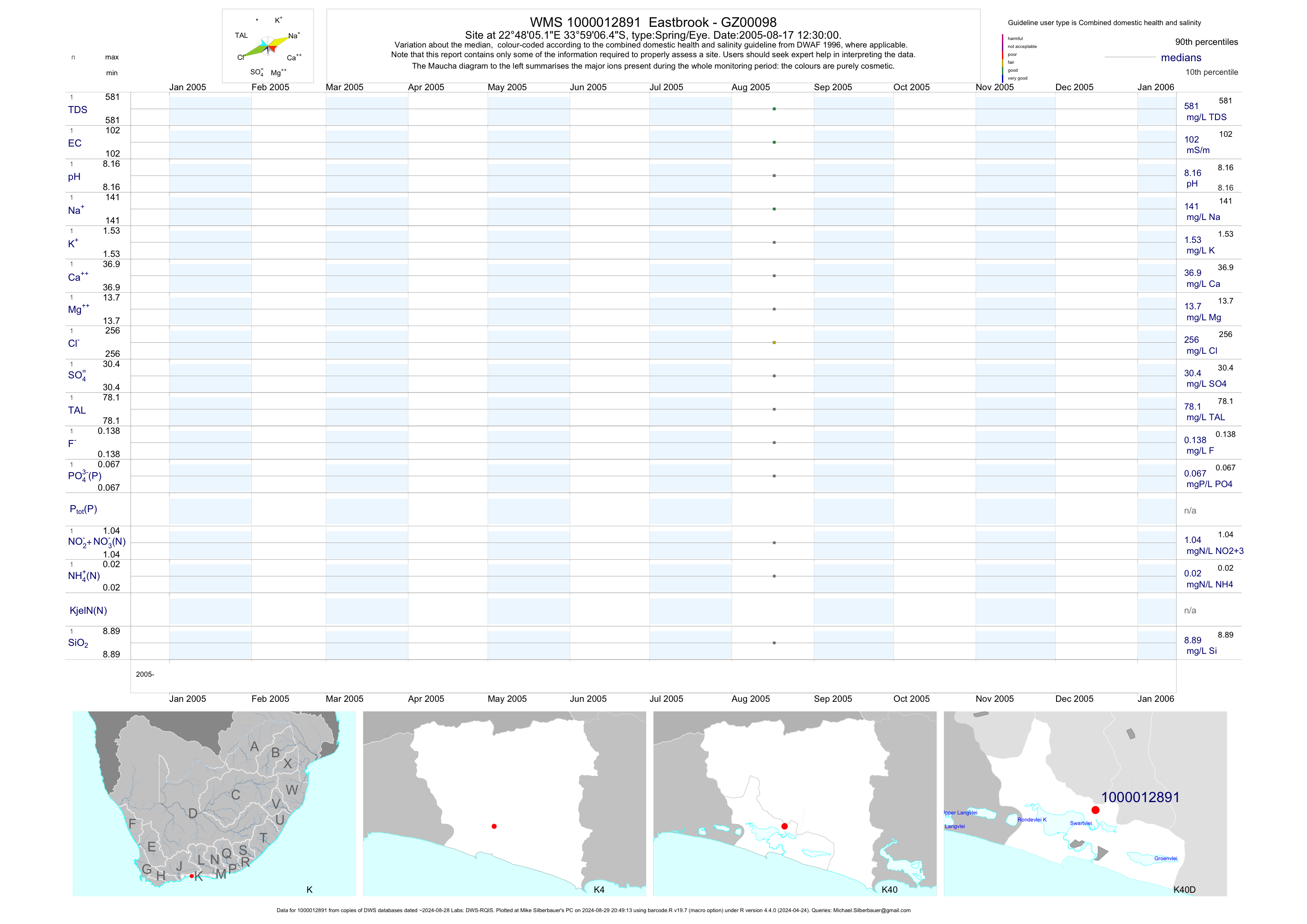
| K40 1000012891 | plot | data | Eastbrook - GZ00098 | Spring/Eye | 2 | 2005-08-17 | 2005-08-17 | 102 | 1-12891 | -33.98513 | 22.80144 |
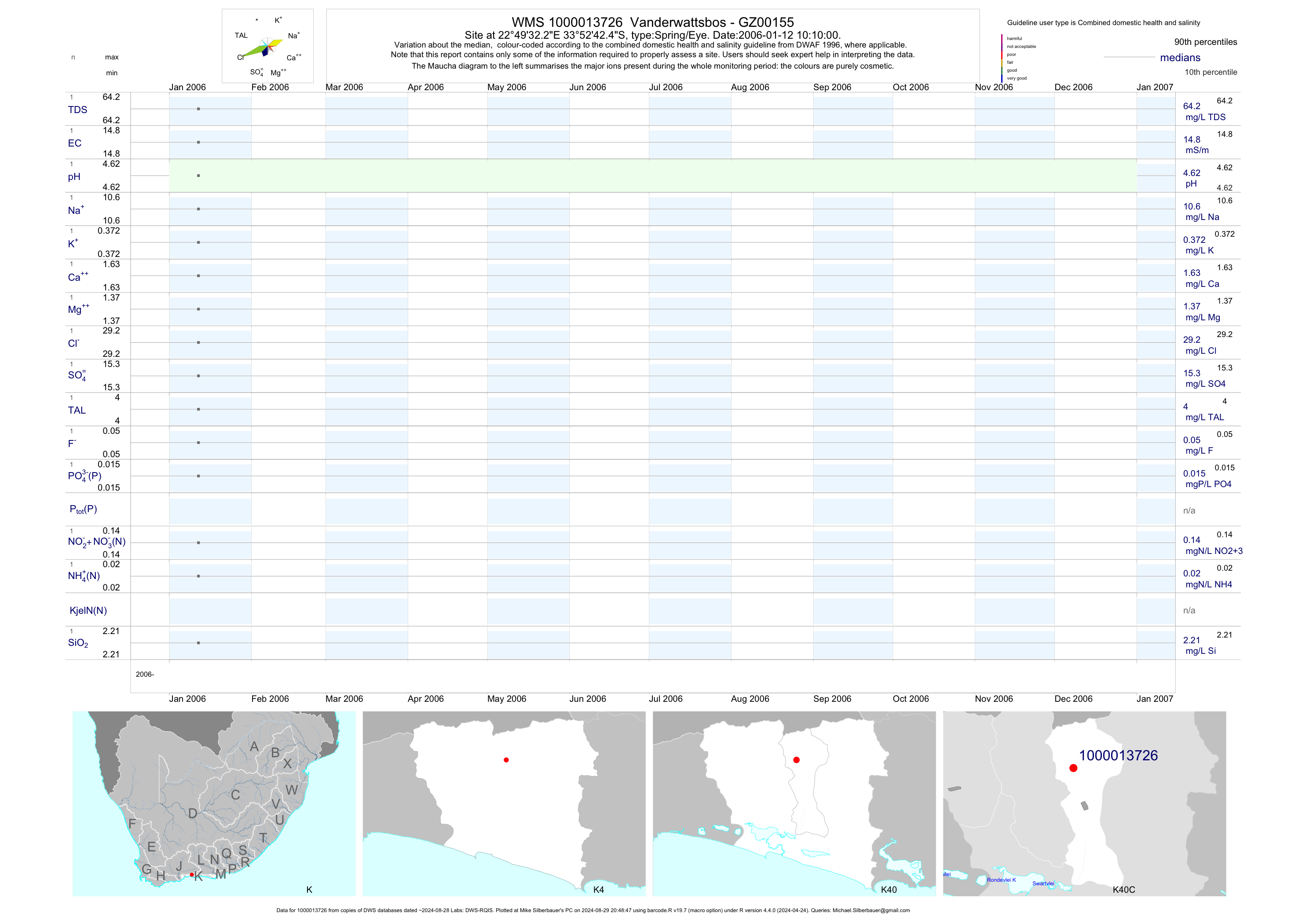
| K40 1000013726 | plot | data | Vanderwattsbos - GZ00155 | Spring/Eye | 2 | 2006-01-12 | 2006-01-12 | 15 | 1-13726 | -33.87844 | 22.82561 |
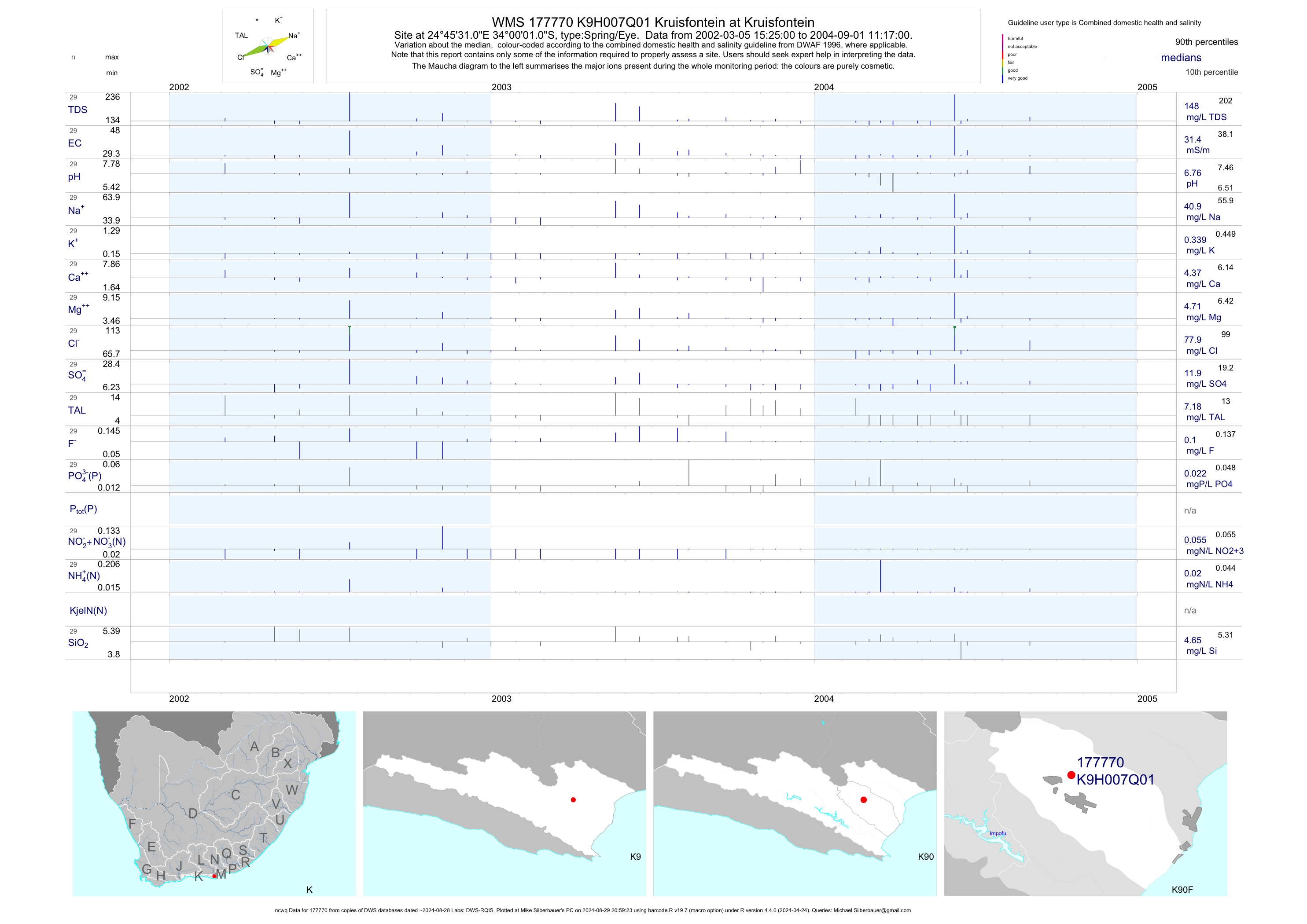
| K90 177770 | plot | data | Kruisfontein at Kruisfontein (ncwq) | Spring/Eye | 29 | 2002-03-05 | 2004-09-01 | 31 | K9H007 | -34.00028 | 24.75861 |
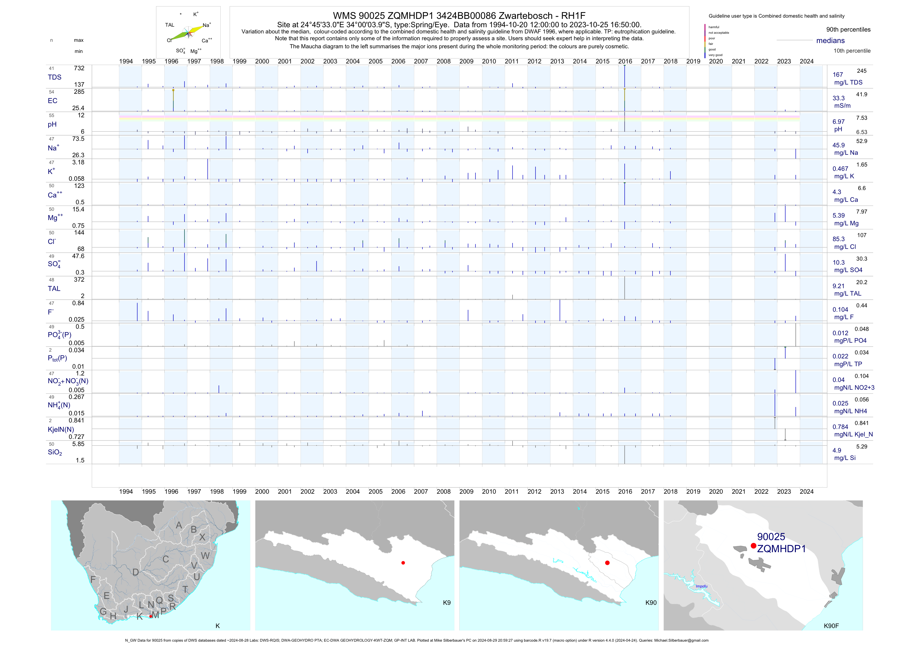
| K90 90025 | plot | data | 3424BB00086 Zwartebosch - RH1F (N_GW) | Spring/Eye | 57 | 1994-10-20 | 2018-04-17 | 33 | ZQMHDP1 | -34.00111 | 24.75917 |
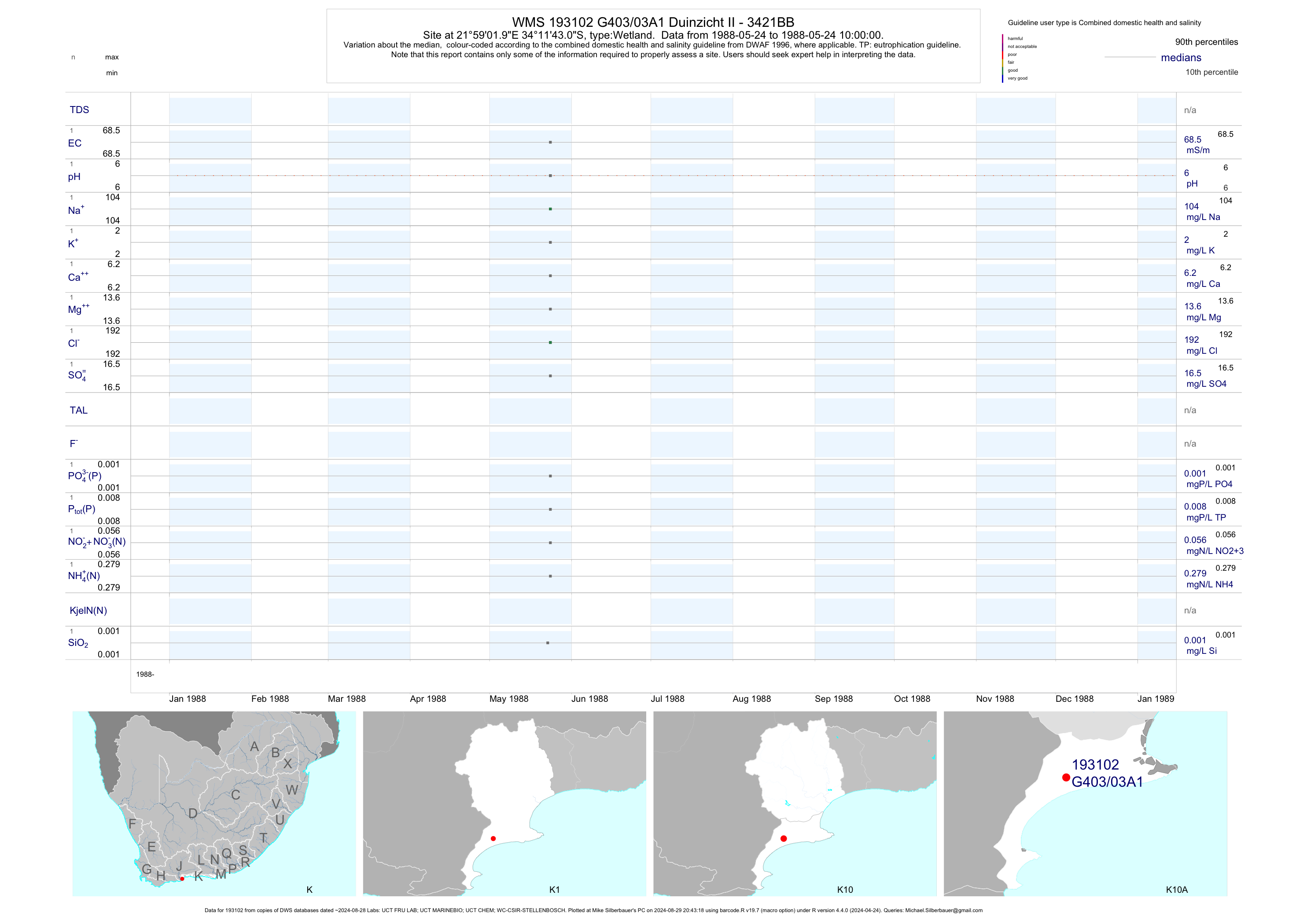
| K10 193102 | plot | data | Duinzicht II - 3421BB | Wetland | 5 | 1988-05-24 | 1988-05-24 | 68 | G403/03A1 | -34.19528 | 21.98389 |
| K10 181477 | plot | data | Duinzicht - 3421BB | Wetland | 1 | 2013-04-28 | 2013-04-28 | 714 | K101/03A1 | -34.18056 | 21.98389 |
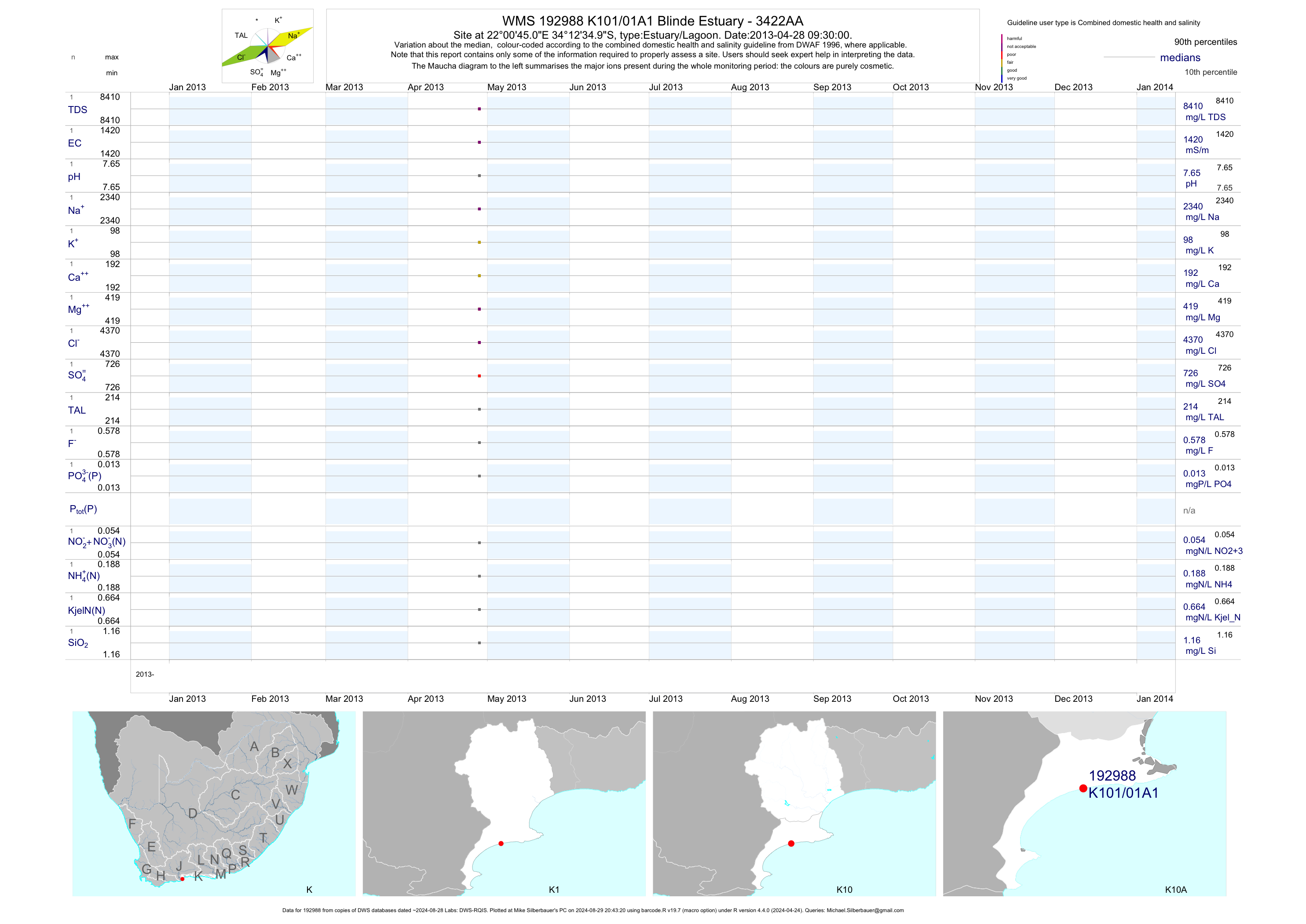
| K10 192988 | plot | data | Blinde Estuary - 3422AA | Estuary/Lagoon | 1 | 2013-04-28 | 2013-04-28 | 1417 | K101/01A1 | -34.20972 | 22.01250 |
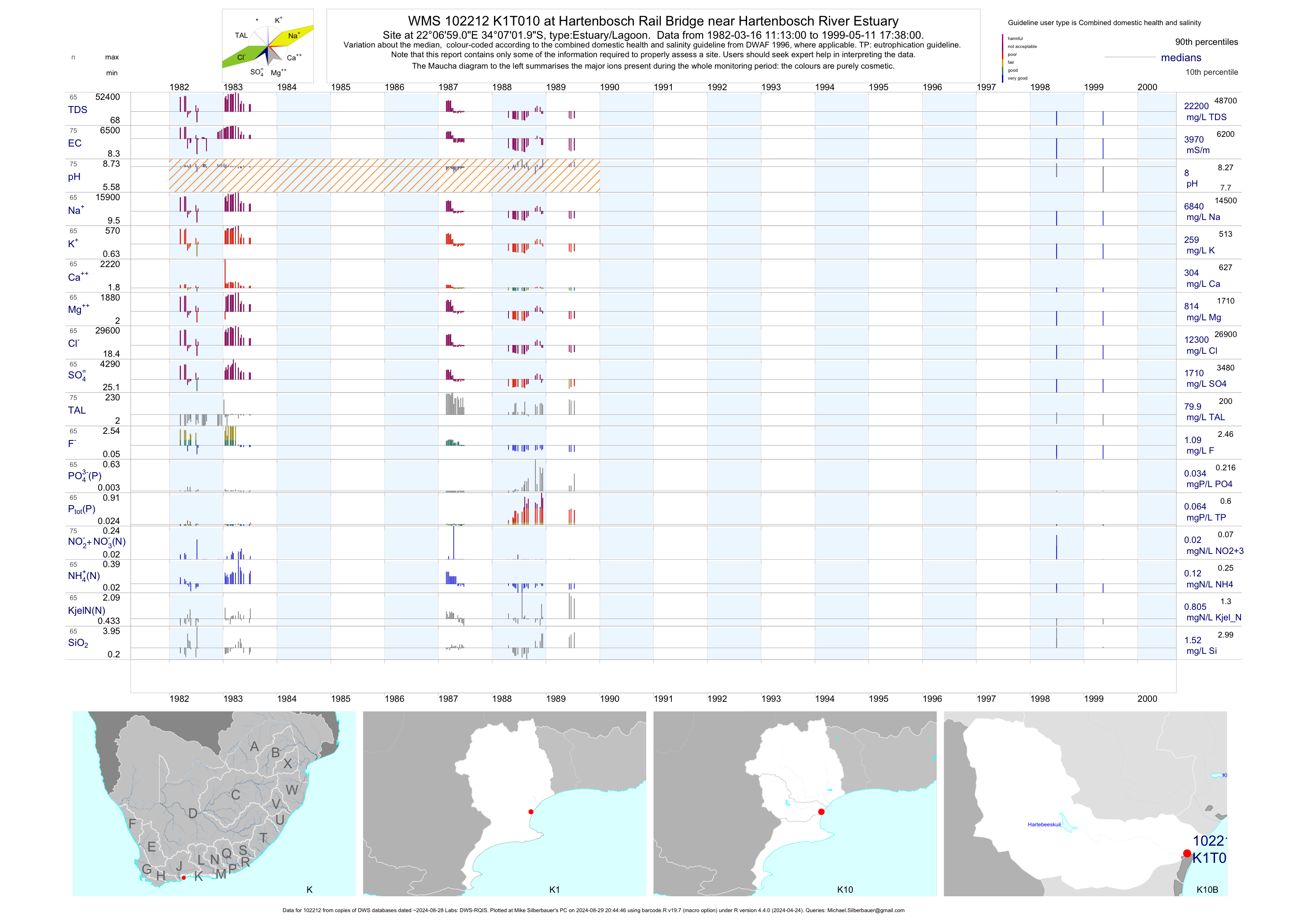
| K10 102212 | plot | data | at Hartenbosch Rail Bridge near Hartenbosch River Estuary | Estuary/Lagoon | 75 | 1982-03-16 | 1999-05-11 | 3968 | K1T010 | -34.11722 | 22.11639 |
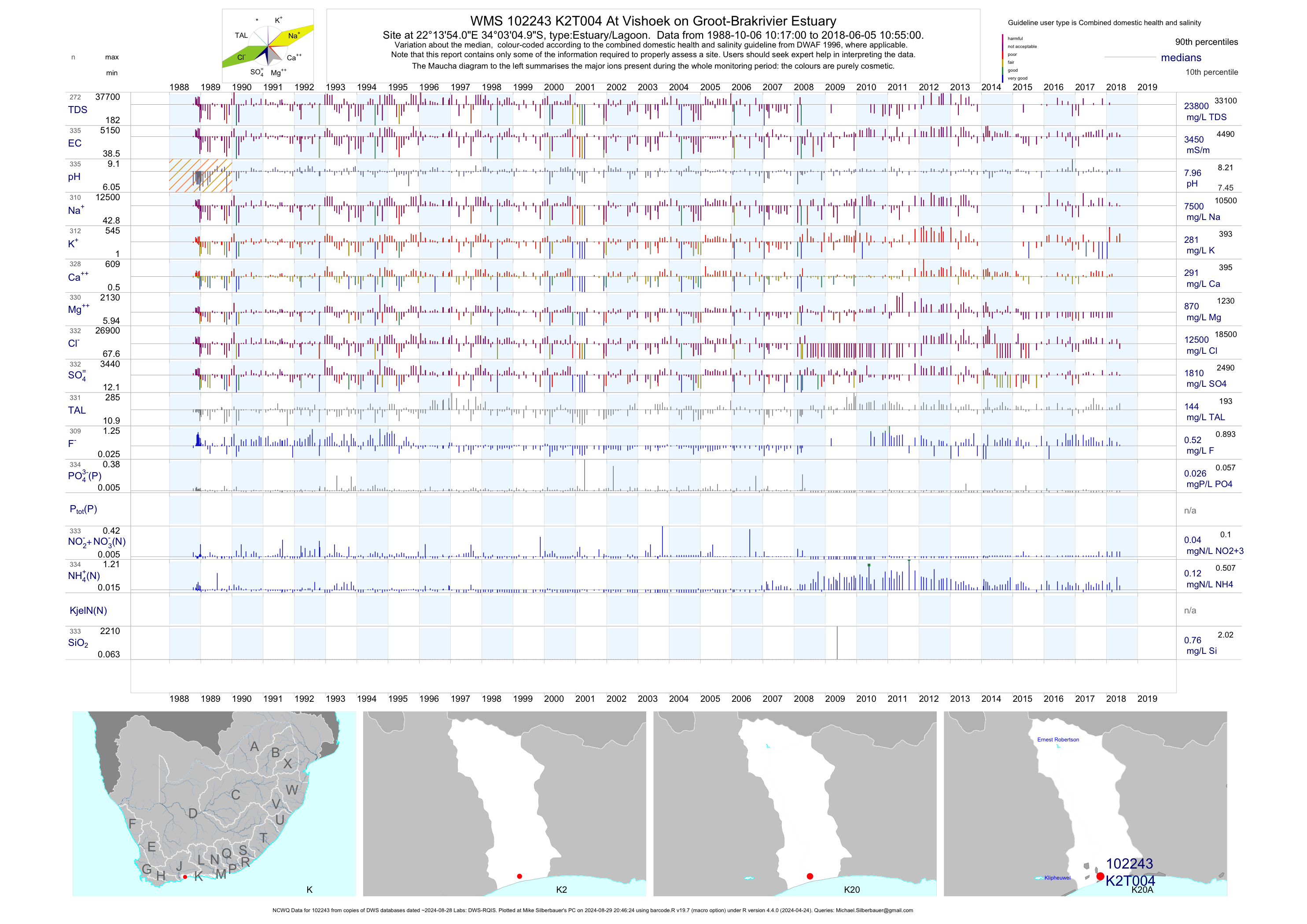
| K20 102243 | plot | data | At Vishoek on Groot-Brakrivier Estuary (NCWQ) | Estuary/Lagoon | 338 | 1988-10-06 | 2018-06-05 | 3447 | K2T004 | -34.05139 | 22.23167 |
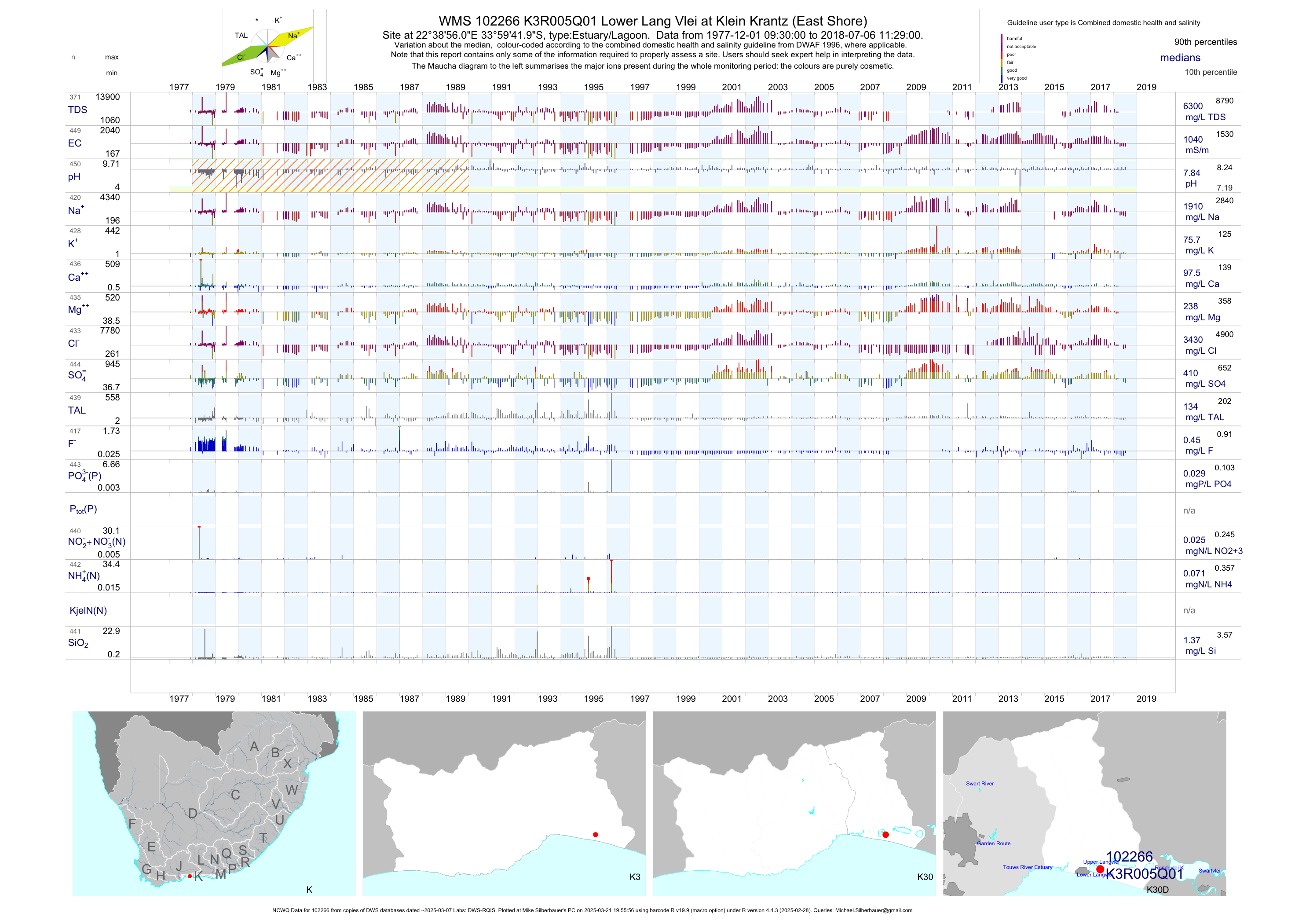
| K30 102266 | plot | data | Lower Lang Vlei at Klein Krantz (East Shore) (NCWQ) Q01 | Estuary/Lagoon | 450 | 1977-12-01 | 2018-07-06 | 1036 | K3R005 | -33.99500 | 22.64889 |
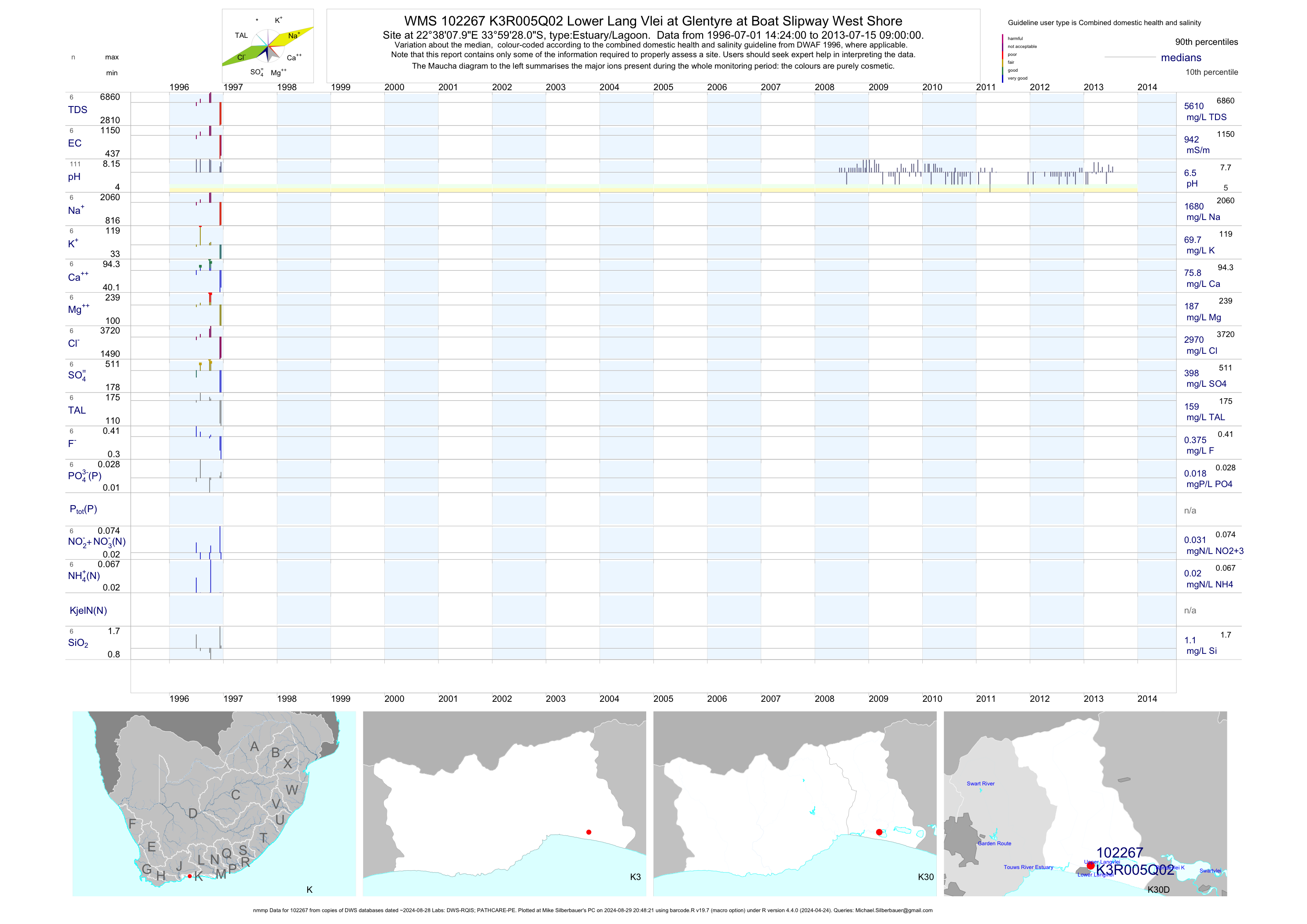
| K30 102267 | plot | data | Lower Lang Vlei at Glentyre at Boat Slipway West Shore (nmmp) Q02 | Estuary/Lagoon | 130 | 1996-07-01 | 2013-07-15 | 942 | K3R005 | -33.99111 | 22.63556 |
| K30 102268 | plot | data | Onder-Langvlei at Duiwe River Inflow at Klein Krantz Q03 | Estuary/Lagoon | 46 | 1998-02-19 | 1999-01-13 | 876 | K3R005 | -33.98917 | 22.64417 |
| K30 102269 | plot | data | Onder-Langvlei (Middle Section) at Klein Krantz Q04 | Estuary/Lagoon | 28 | 1998-02-19 | 1999-01-13 | 870 | K3R005 | -33.99278 | 22.64194 |
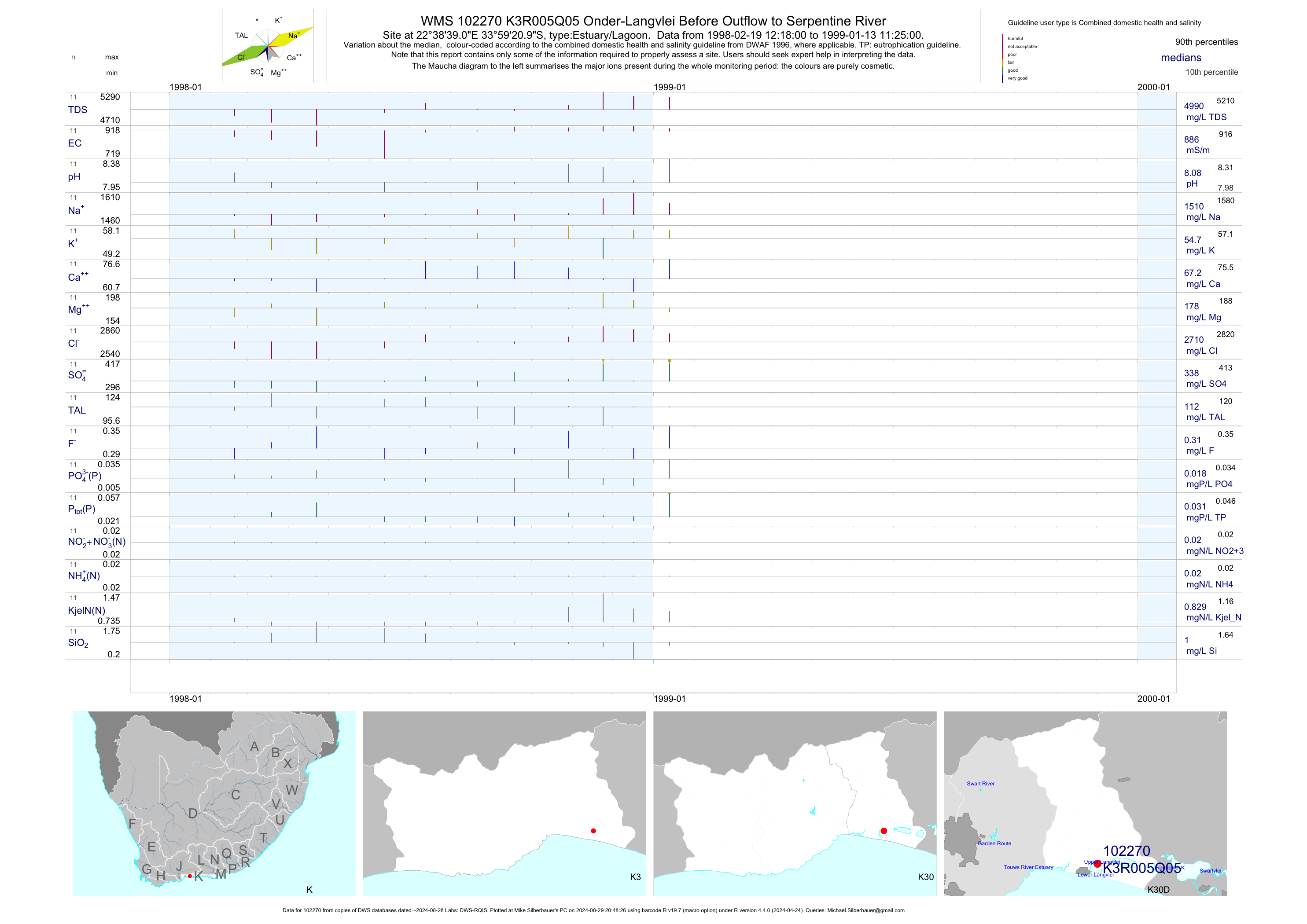
| K30 102270 | plot | data | Onder-Langvlei Before Outflow to Serpentine River Q05 | Estuary/Lagoon | 44 | 1998-02-19 | 1999-01-13 | 886 | K3R005 | -33.98917 | 22.64417 |
| K30 102272 | plot | data | Wilderness Lagoon at Crows Nest/Wilderness Q02 | Estuary/Lagoon | 24 | 1998-02-05 | 1999-01-15 | 912 | K3R006 | -33.99290 | 22.58730 |
| K30 102273 | plot | data | Wilderness Lagoon at N2 ;the Lakes/Wilderness Q03 | Estuary/Lagoon | 50 | 1998-02-05 | 1999-01-15 | 879 | K3R006 | -33.99639 | 22.60111 |
| K30 102274 | plot | data | Wilderness at Wilderness Lagoon (Touws River Estuary) Q04 | Estuary/Lagoon | 24 | 1998-02-05 | 1999-01-15 | 778 | K3R006 | -33.99361 | 22.59639 |
| K30 102271 | plot | data | Touws River Estuary at Wilderness (NCWQ) | Estuary/Lagoon | 408 | 1977-12-01 | 2018-07-06 | 1410 | K3T006 | -33.99333 | 22.59778 |
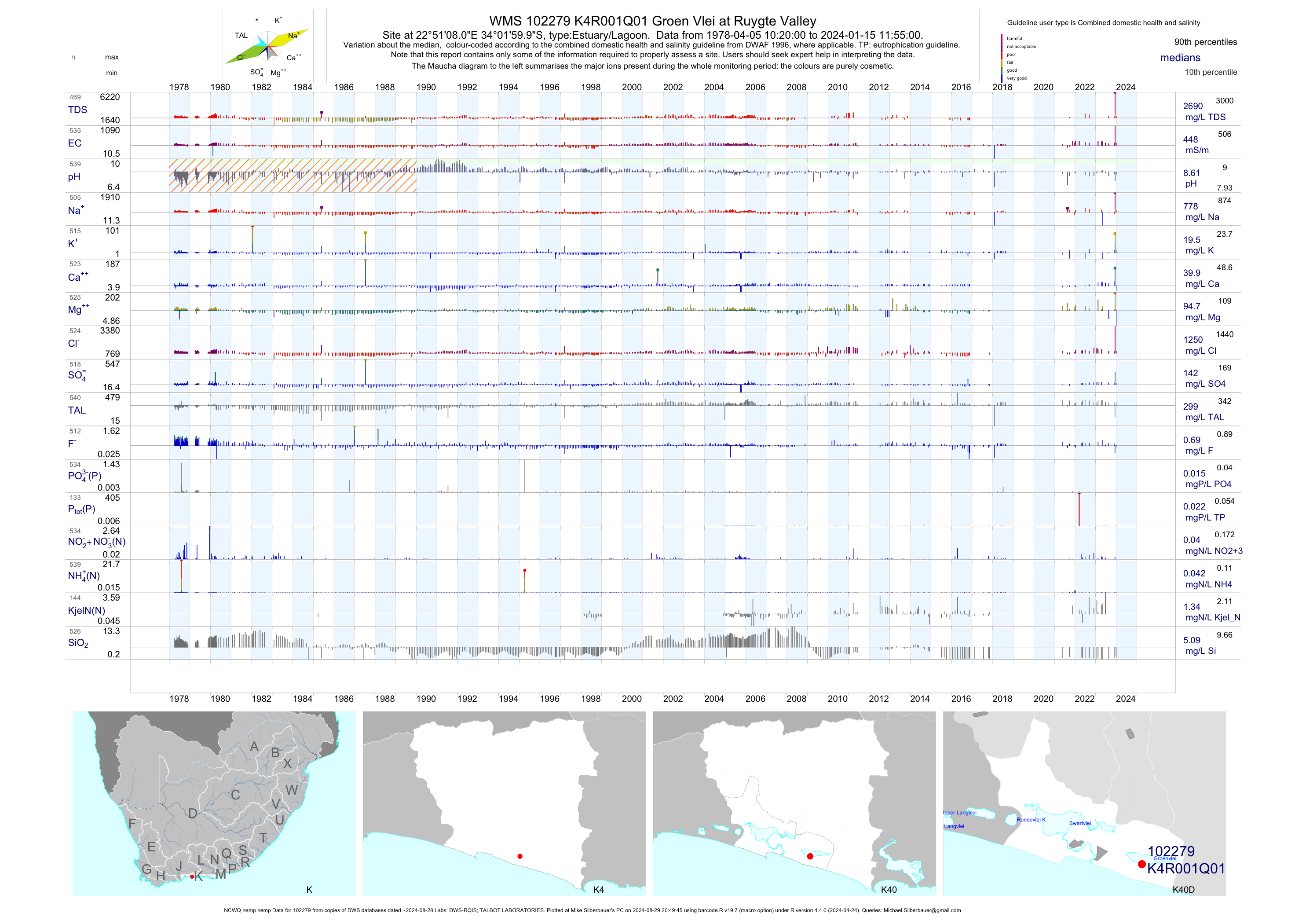
| K40 102279 | plot | data | Groen Vlei at Ruygte Valley (NCWQ nemp nemp) Q01 | Estuary/Lagoon | 1229 | 1978-04-05 | 2019-05-24 | 446 | K4R001 | -34.03333 | 22.85222 |
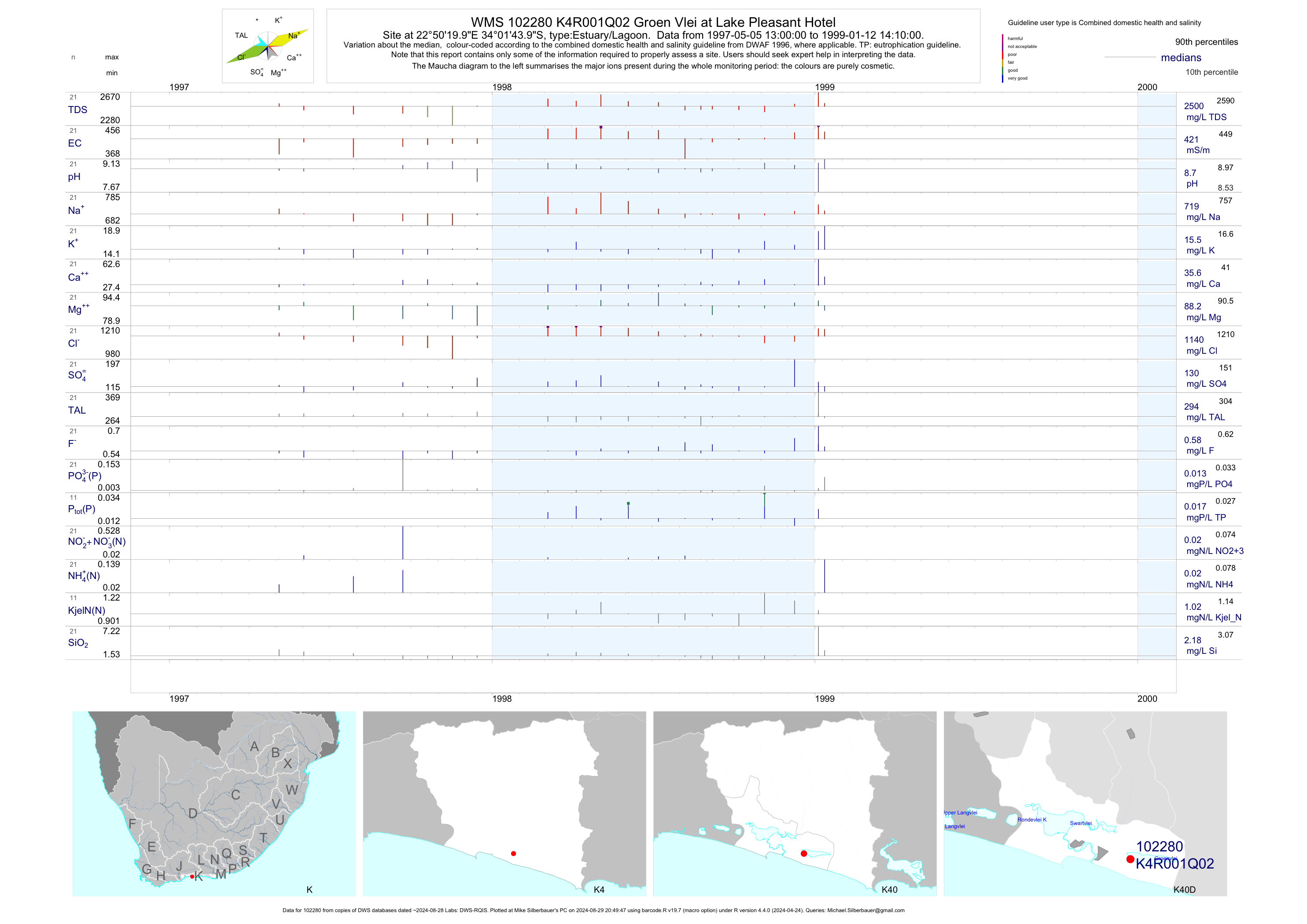
| K40 102280 | plot | data | Groen Vlei at Lake Pleasant Hotel Q02 | Estuary/Lagoon | 56 | 1997-05-05 | 1999-01-12 | 421 | K4R001 | -34.02889 | 22.83889 |
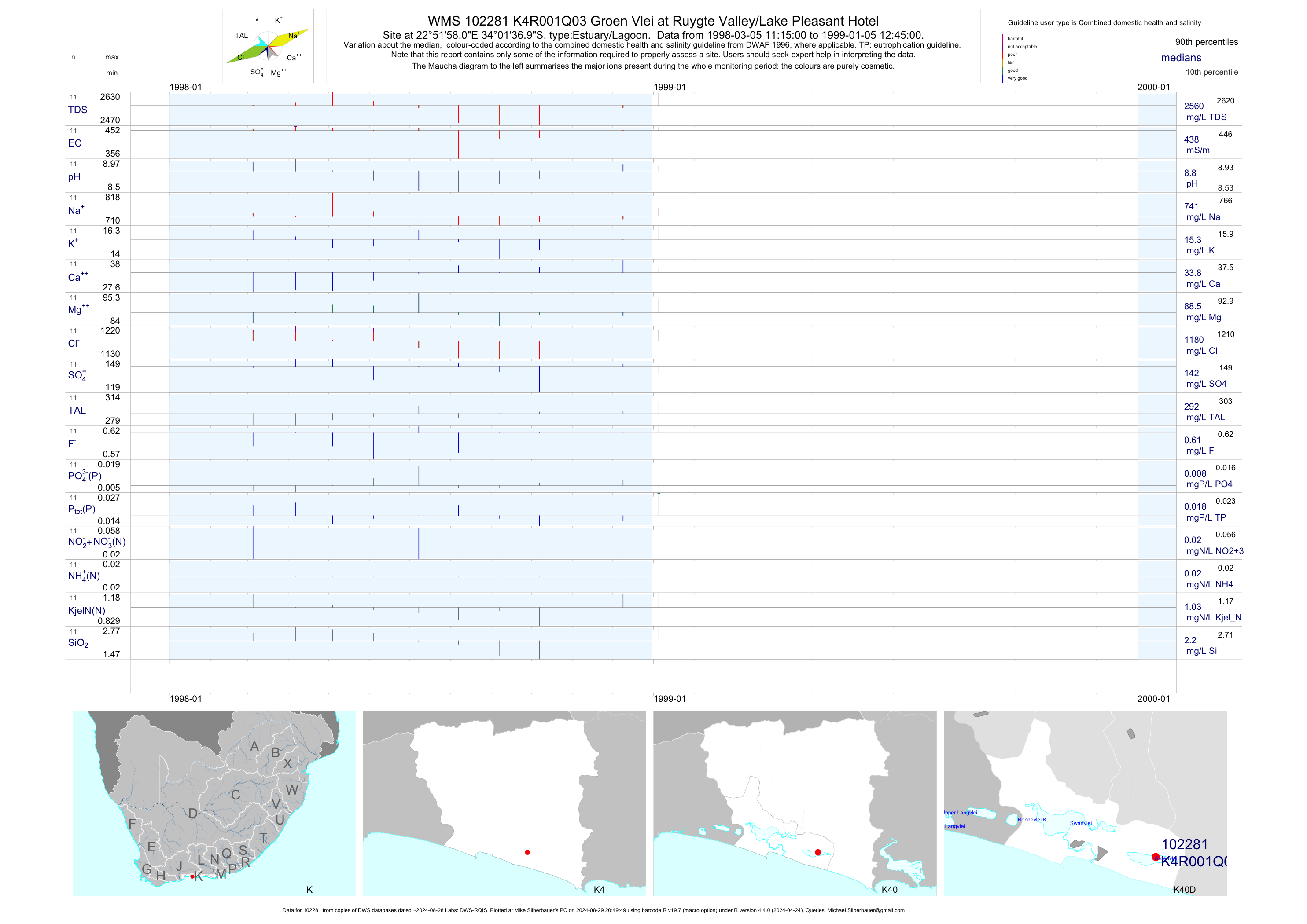
| K40 102281 | plot | data | Groen Vlei at Ruygte Valley/Lake Pleasant Hotel Q03 | Estuary/Lagoon | 57 | 1998-02-04 | 1999-01-05 | 438 | K4R001 | -34.02694 | 22.86611 |
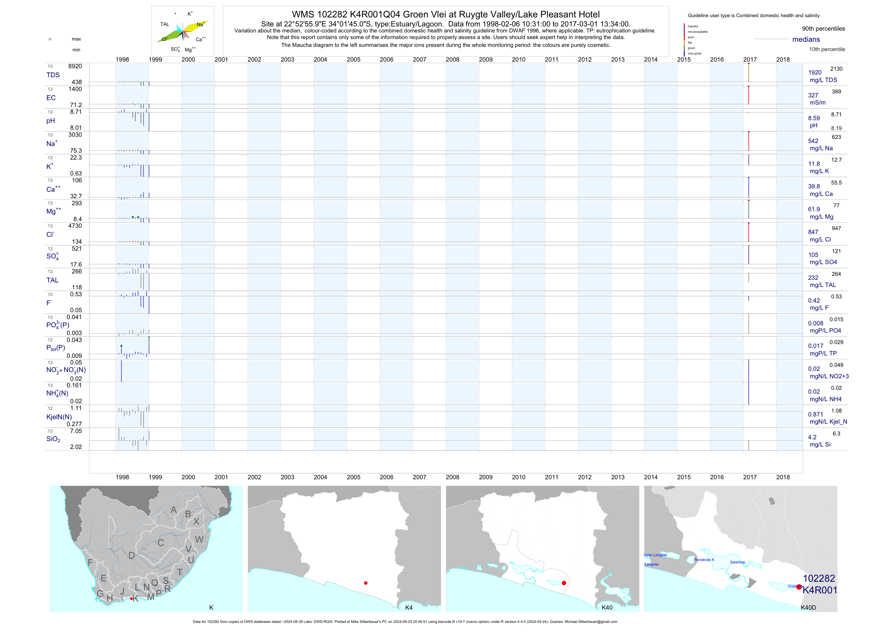
| K40 102282 | plot | data | Groen Vlei at Ruygte Valley/Lake Pleasant Hotel Q04 | Estuary/Lagoon | 25 | 1998-02-06 | 2017-03-01 | 327 | K4R001 | -34.02917 | 22.88222 |
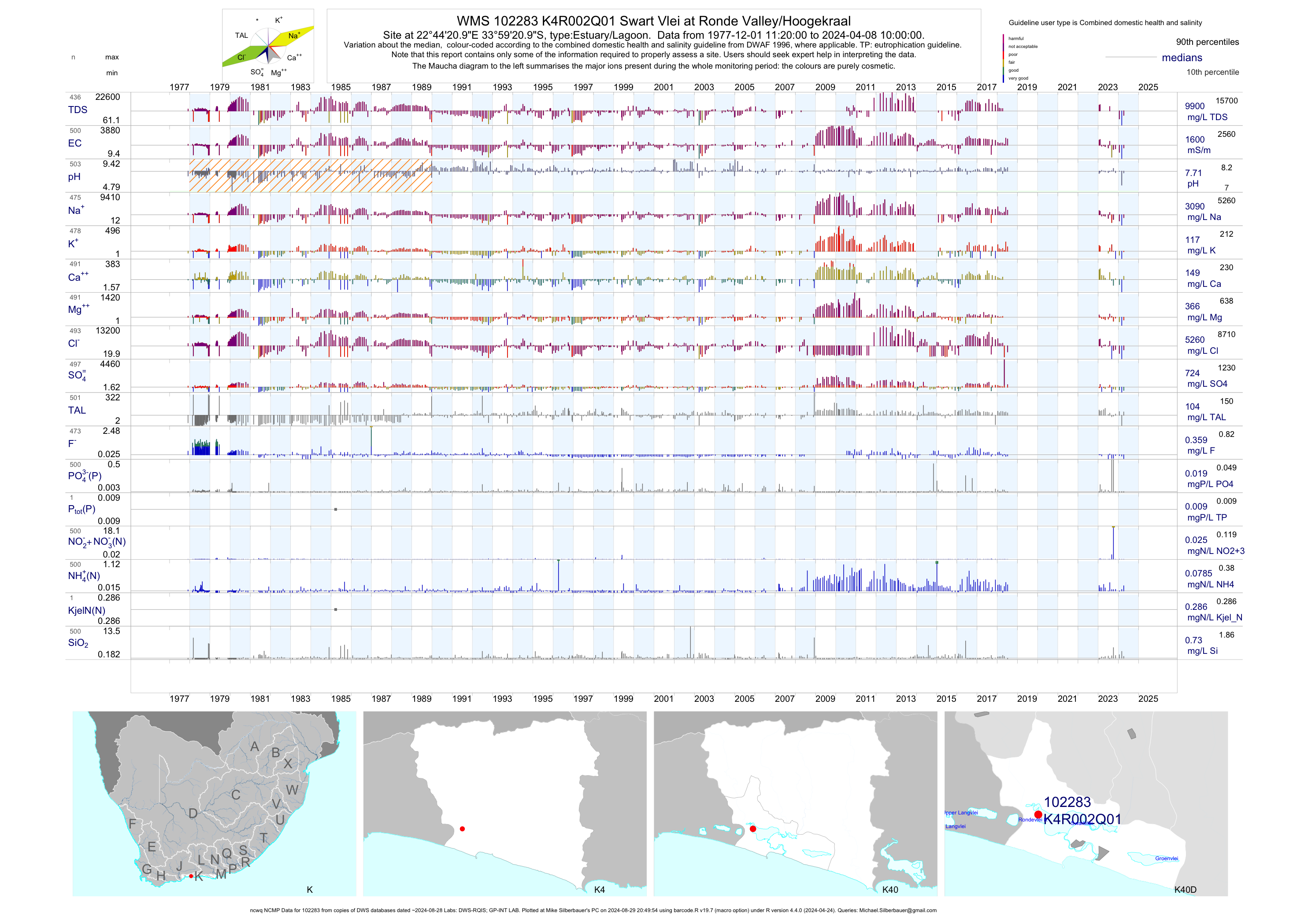
| K40 102283 | plot | data | Swart Vlei at Ronde Valley/Hoogekraal (ncwq NCMP) Q01 | Estuary/Lagoon | 490 | 1977-12-01 | 2018-07-09 | 1610 | K4R002 | -33.98917 | 22.73917 |
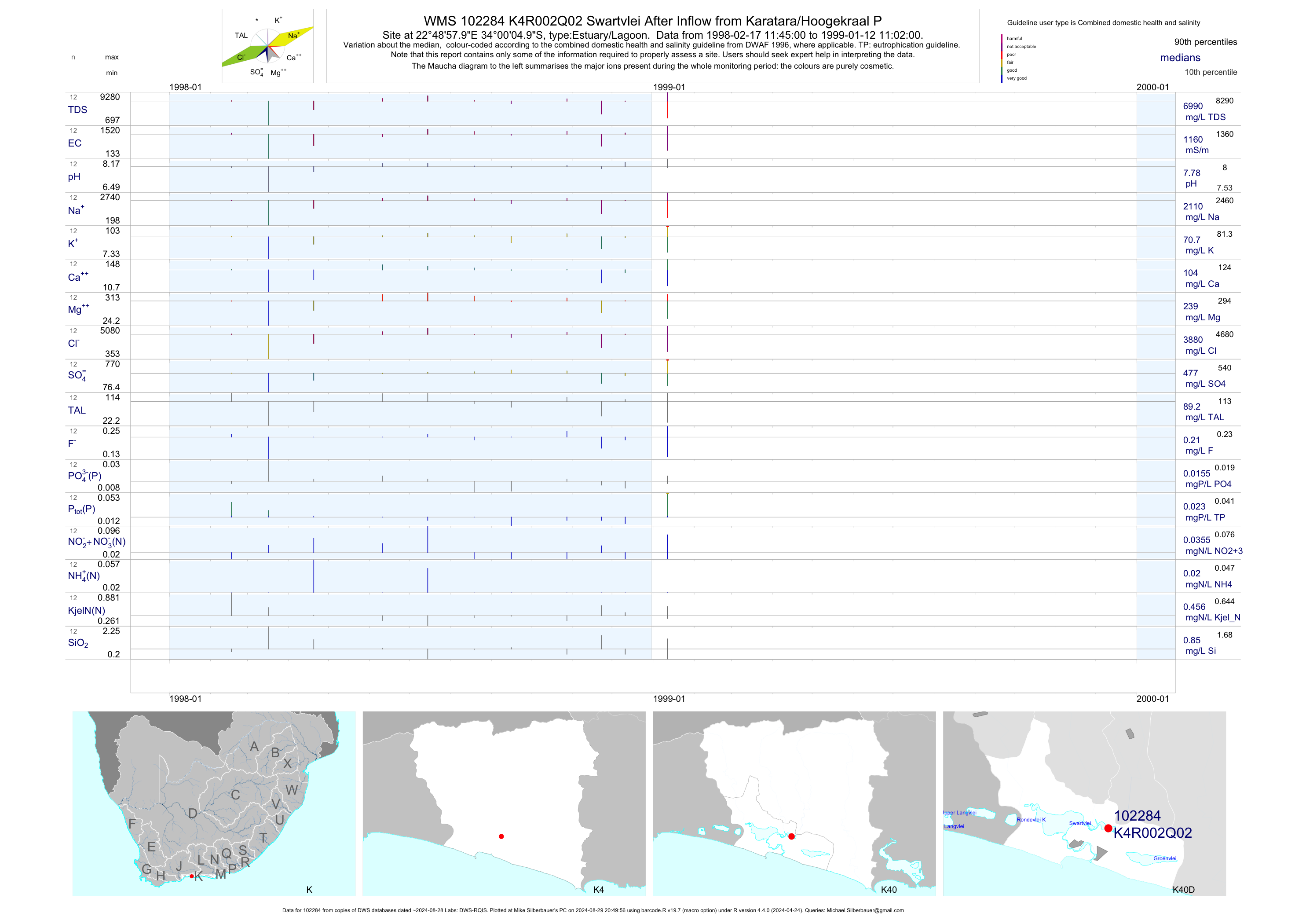
| K40 102284 | plot | data | Swartvlei After Inflow from Karatara/Hoogekraal P Q02 | Estuary/Lagoon | 23 | 1998-02-17 | 1999-01-12 | 1161 | K4R002 | -34.00139 | 22.81611 |
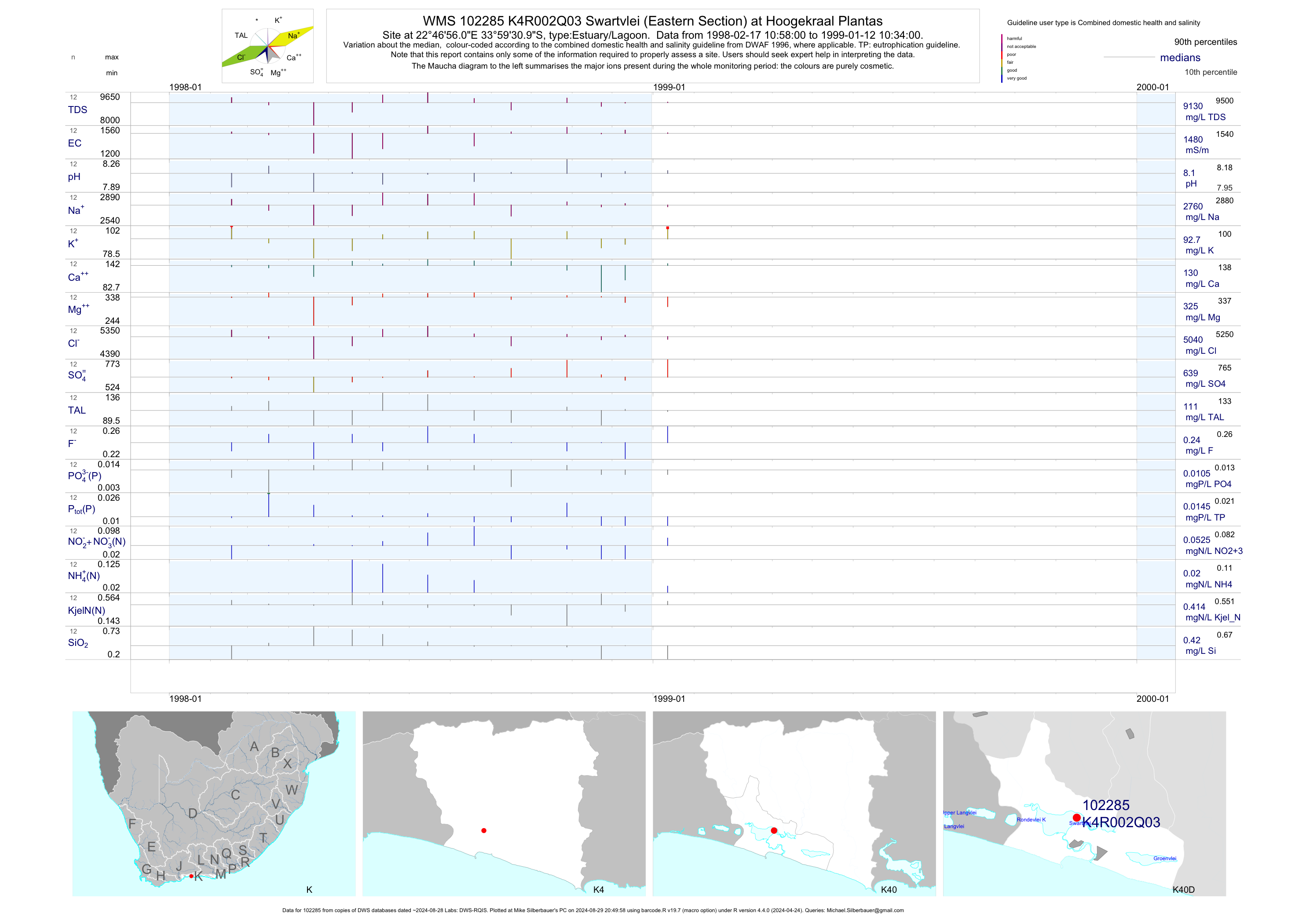
| K40 102285 | plot | data | Swartvlei (Eastern Section) at Hoogekraal Plantas Q03 | Estuary/Lagoon | 48 | 1998-02-17 | 1999-01-12 | 1475 | K4R002 | -33.99194 | 22.78222 |
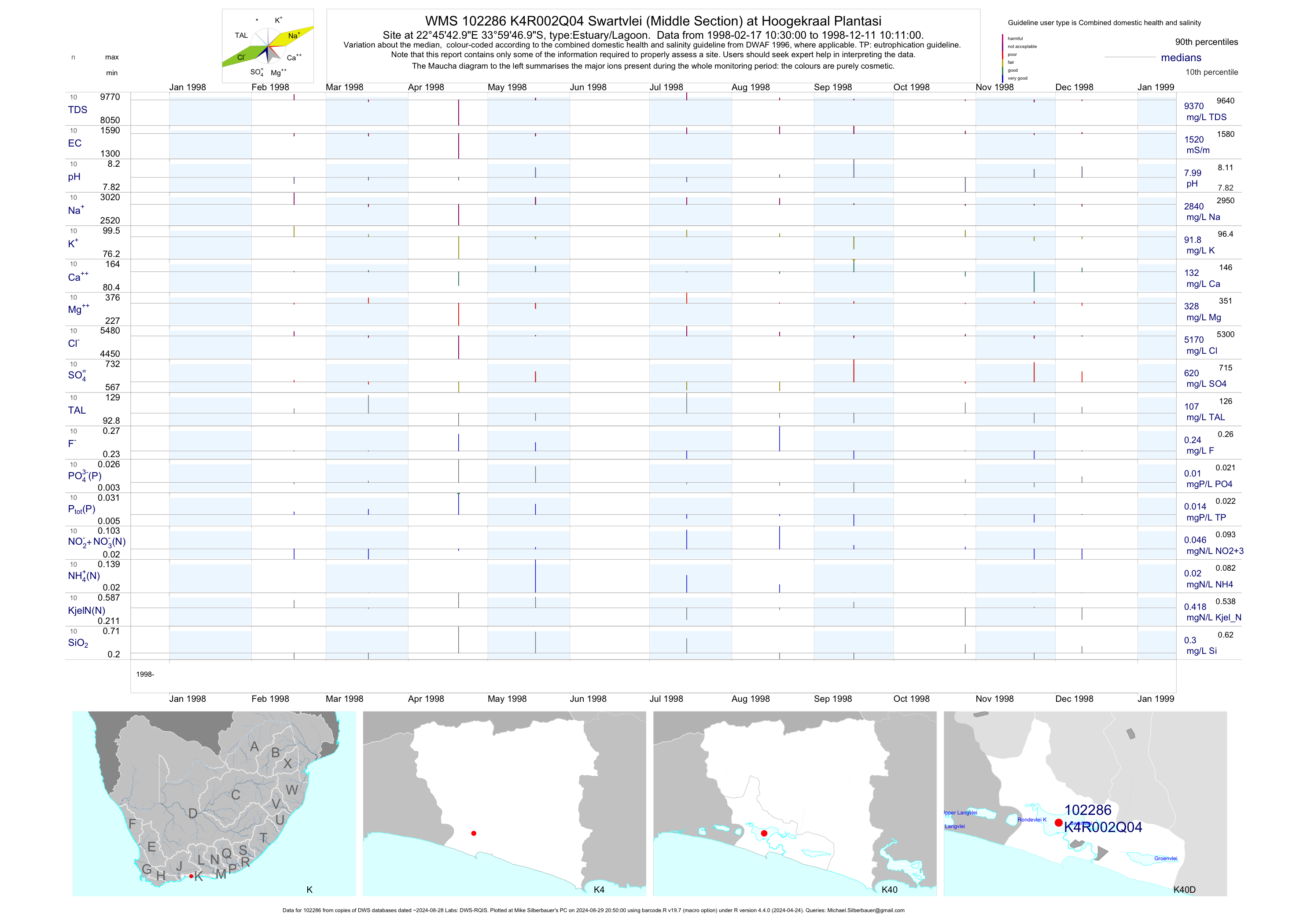
| K40 102286 | plot | data | Swartvlei (Middle Section) at Hoogekraal Plantasi Q04 | Estuary/Lagoon | 23 | 1998-02-17 | 1999-01-12 | 1520 | K4R002 | -33.99639 | 22.76194 |
| K40 102287 | plot | data | Swartvlei (Western Section) at Ronde Valley Q05 | Estuary/Lagoon | 52 | 1998-02-17 | 1999-01-12 | 1530 | K4R002 | -33.99722 | 22.74722 |
| K40 102288 | plot | data | Sedgefield Lagoon at Round Hill/Lot KD 185 Q01 | Estuary/Lagoon | 23 | 1998-02-17 | 1999-01-12 | 2655 | K4R003 | -34.02972 | 22.79778 |
| K40 102289 | plot | data | Sedgefield Lagoon at Kingfisher Draai /Sedgefield Q02 | Estuary/Lagoon | 23 | 1998-02-17 | 1999-01-12 | 2550 | K4R003 | -34.01806 | 22.79667 |
| K40 102290 | plot | data | Sedgefield Lagoon at President Steyn Draai / Sedg Q03 | Estuary/Lagoon | 51 | 1998-02-17 | 1999-01-12 | 2405 | K4R003 | -34.02167 | 22.78500 |
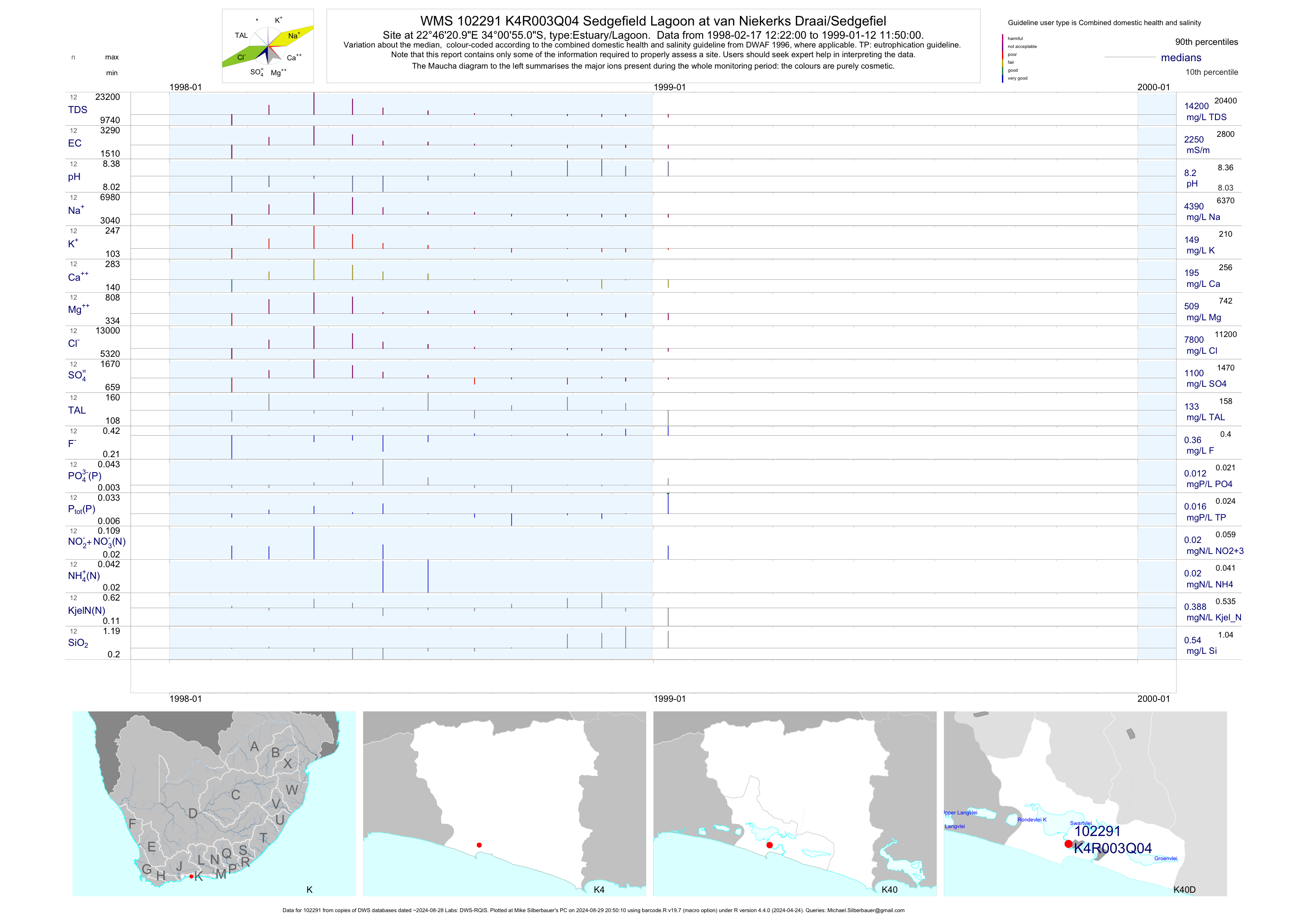
| K40 102291 | plot | data | Sedgefield Lagoon at van Niekerks Draai/Sedgefiel Q04 | Estuary/Lagoon | 23 | 1998-02-17 | 1999-01-12 | 2250 | K4R003 | -34.01528 | 22.77250 |
| K40 193341 | n/a | n/a | D/S N2 Bridge; near Inflow from Swartvlei Lake at Swartvlei Estuary (NEMP) | Estuary/Lagoon | 2 | 2013-01-07 | 2013-04-06 | n/a | SVE-01 | -34.00975 | 22.76501 |
| K40 193343 | n/a | n/a | 4.7KM from Mouth Off Hertzog Street at Swartvlei Estuary (NEMP) | Estuary/Lagoon | 1 | 2013-04-08 | 2013-04-08 | n/a | SVE-03 | -34.01923 | 22.77723 |
| K40 193344 | n/a | n/a | 4.1KM from Mouth at Swartvlei Estuary (NEMP) | Estuary/Lagoon | 1 | 2013-04-08 | 2013-04-08 | n/a | SVE-04 | -34.02197 | 22.78208 |
| K40 193330 | n/a | n/a | Estuary Mouth at Swartvlei Estuary (NEMP) | Estuary/Lagoon | 2 | 2013-01-07 | 2013-04-08 | n/a | SVE-08 | -34.03031 | 22.79695 |
| K40 193331 | n/a | n/a | Near Diep and Klein Wolwe River Inflows at Swartvlei Estuary (NEMP) | Estuary/Lagoon | 1 | 2013-04-17 | 2013-04-17 | n/a | SVL-01 | -33.98599 | 22.74035 |
| K40 193333 | n/a | n/a | Off Pine Lake Marina at Swartvlei Estuary (NEMP) | Estuary/Lagoon | 1 | 2013-01-07 | 2013-01-07 | n/a | SVL-03 | -34.00368 | 22.74883 |
| K40 193336 | n/a | n/a | Near Hoekraal and Karatara River Inflows at Swartvlei Estuary (NEMP) | Estuary/Lagoon | 2 | 2013-01-07 | 2013-04-17 | n/a | SVL-06 | -33.99239 | 22.78622 |
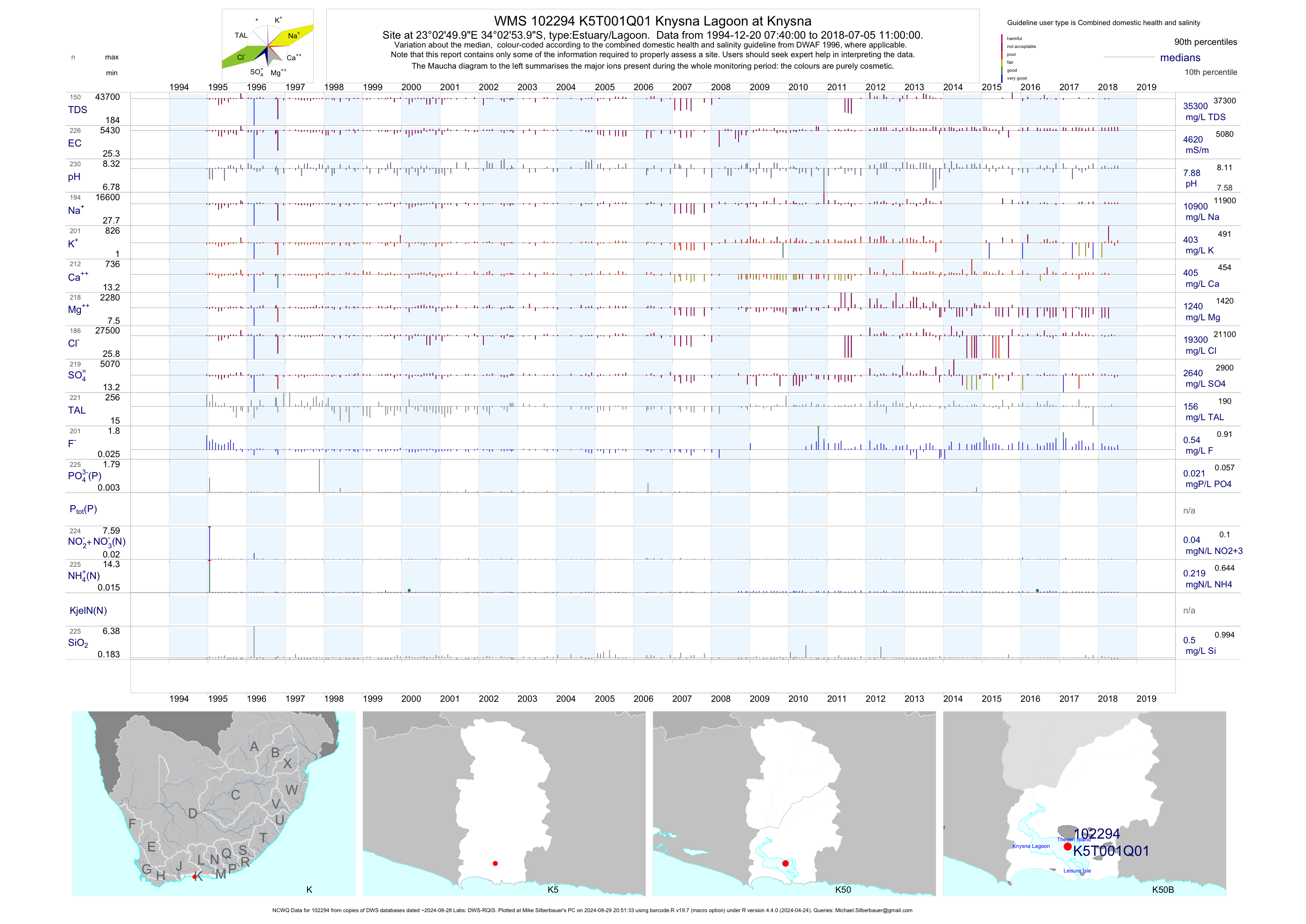
| K50 102294 | plot | data | Knysna Lagoon at Knysna (NCWQ) | Estuary/Lagoon | 229 | 1994-12-20 | 2018-07-05 | 4625 | K5T001 | -34.04833 | 23.04722 |
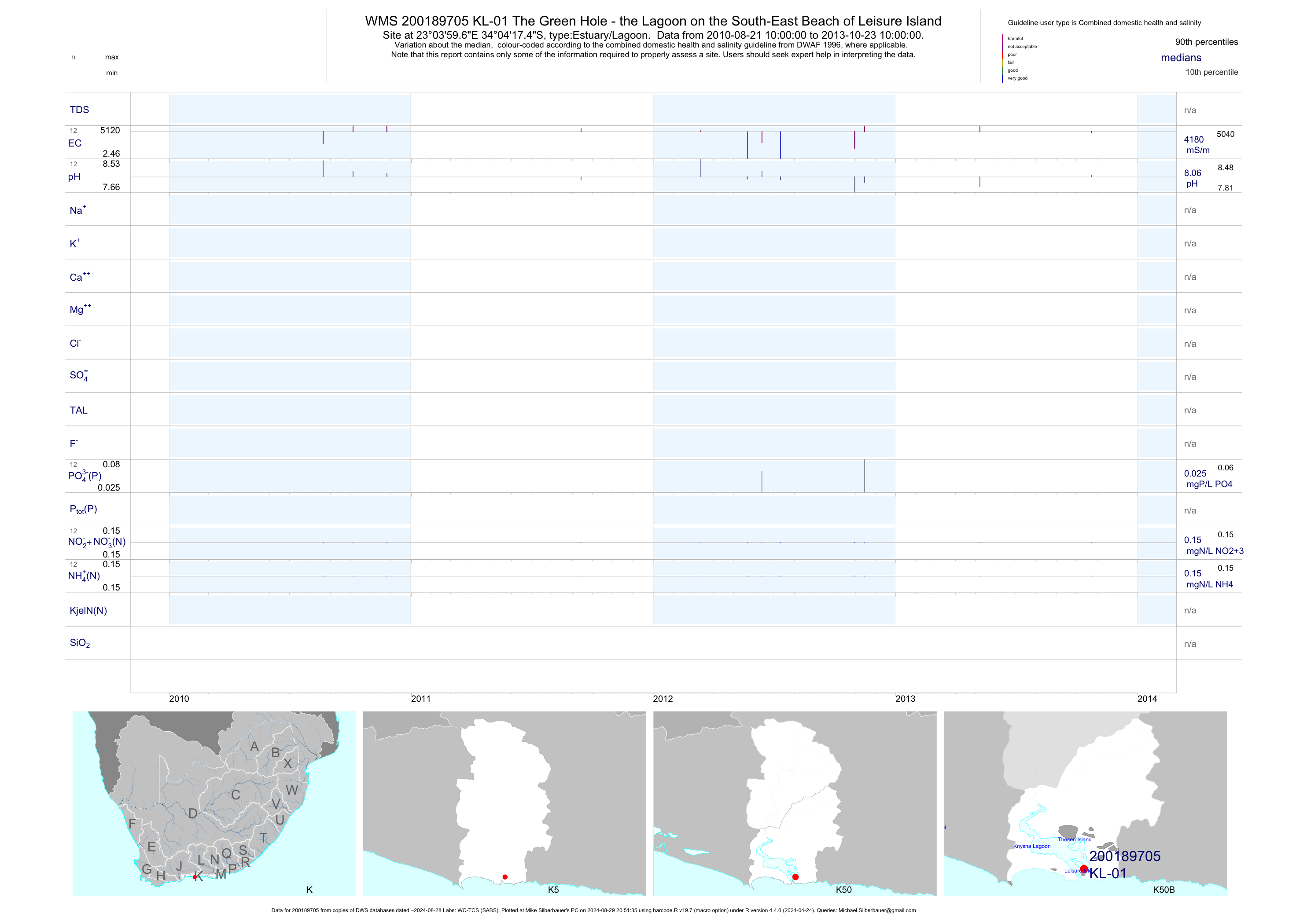
| K50 200189705 | plot | data | The Green Hole - the Lagoon on the South-East Beach of Leisure Island | Estuary/Lagoon | 23 | 2010-08-21 | 2013-10-23 | 4175 | KL-01 | -34.07150 | 23.06657 |
| K50 200189706 | plot | data | Bollard Bay - the Lagoon on the South-West Beach of Leisure Island | Estuary/Lagoon | 23 | 2010-08-21 | 2013-10-23 | 4970 | KL-02 | -34.06676 | 23.05533 |
| K50 200189707 | plot | data | Bigai River - Drains a Low-Cost;high-Density Formal Housing Area to the East of Lagoon | Estuary/Lagoon | 27 | 2010-08-21 | 2013-10-23 | 71 | KL-03 | -34.06177 | 23.07558 |
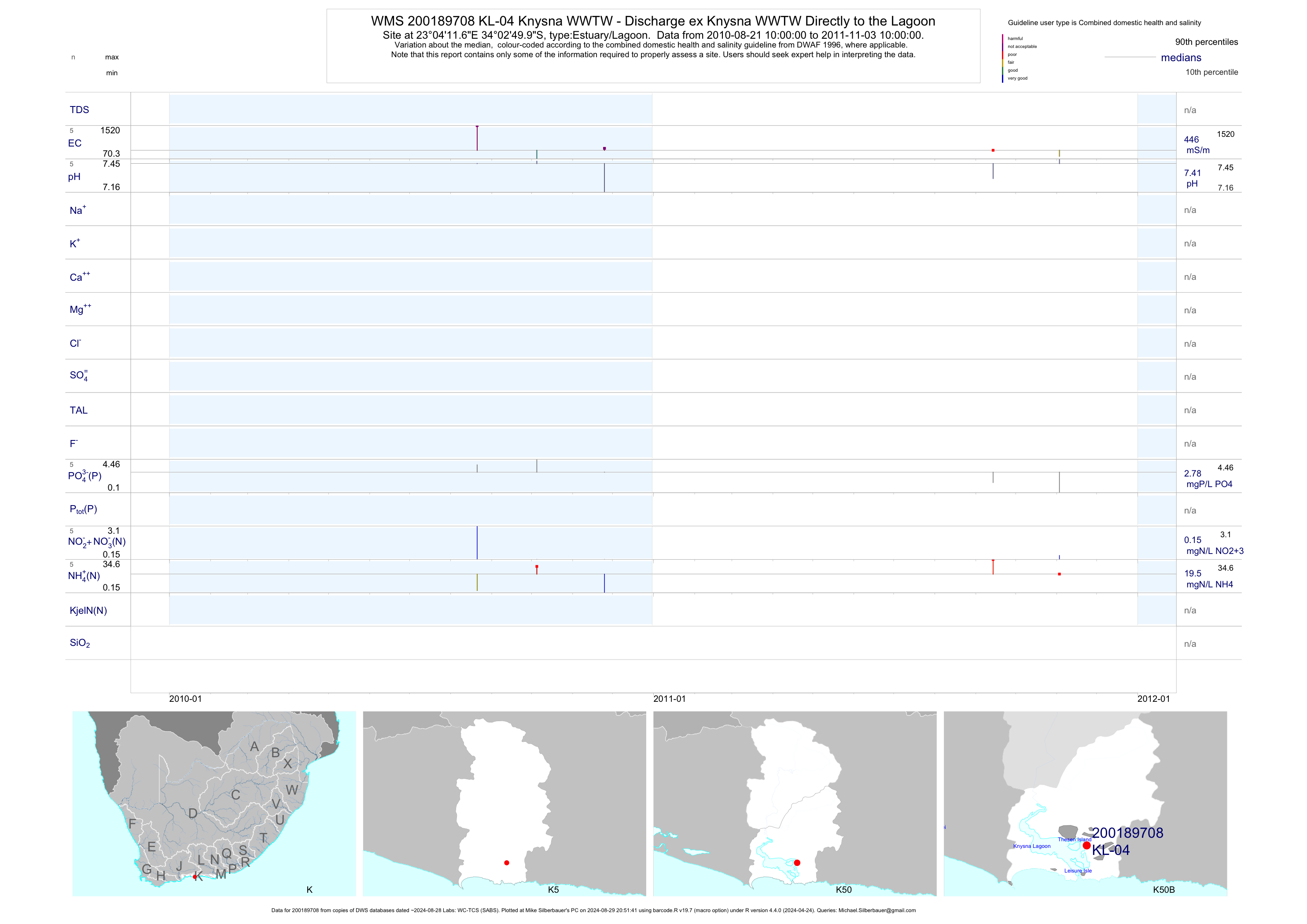
| K50 200189708 | plot | data | Knysna WWTW - Discharge ex Knysna WWTW Directly to the Lagoon | Estuary/Lagoon | 9 | 2010-08-21 | 2011-11-04 | 446 | KL-04 | -34.04721 | 23.06991 |
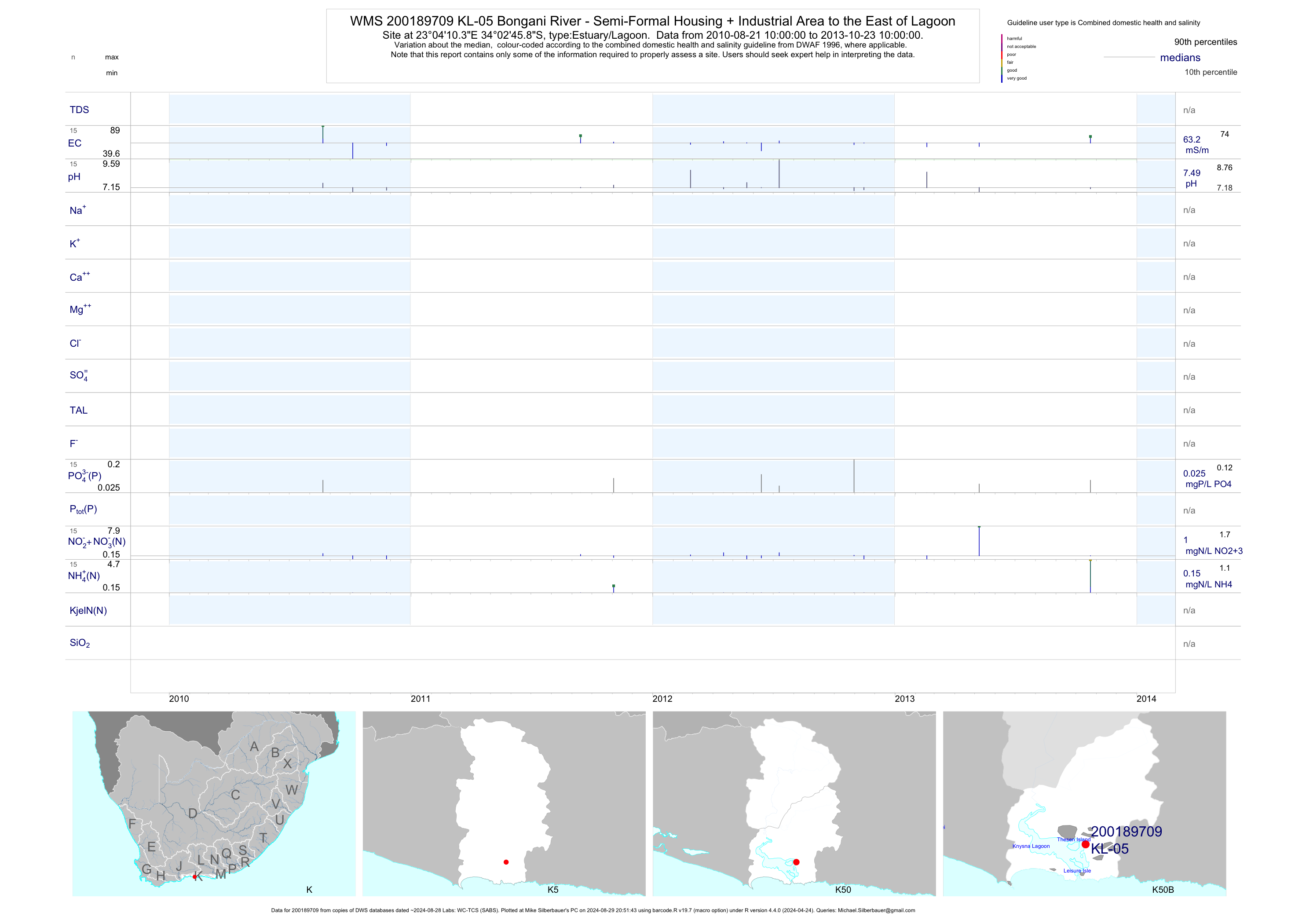
| K50 200189709 | plot | data | Bongani River - Semi-Formal Housing + Industrial Area to the East of Lagoon | Estuary/Lagoon | 27 | 2010-08-21 | 2013-10-23 | 63 | KL-05 | -34.04606 | 23.06955 |
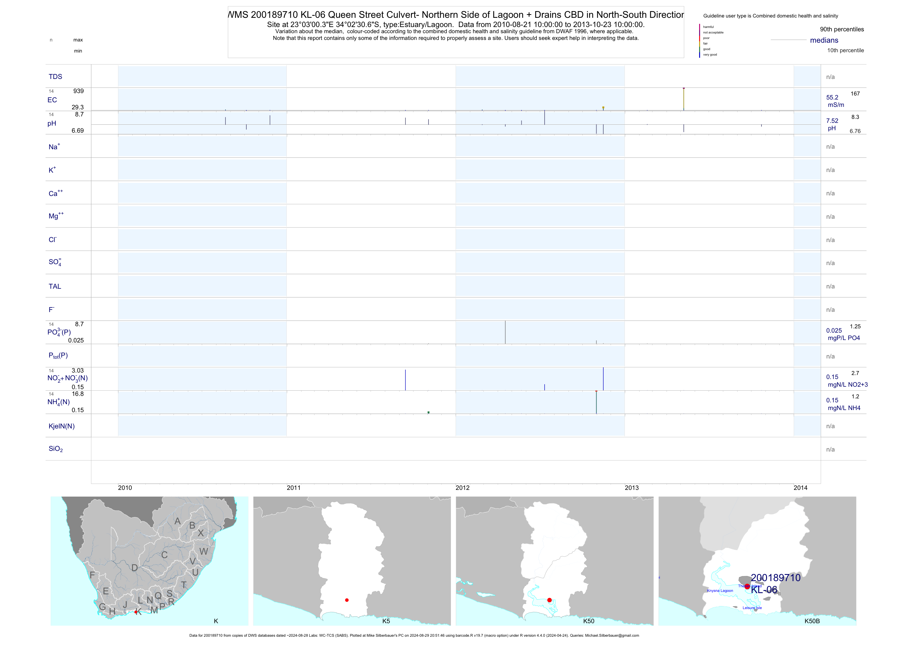
| K50 200189710 | plot | data | Queen Street Culvert- Northern Side of Lagoon + Drains CBD in North-South Direction | Estuary/Lagoon | 25 | 2010-08-21 | 2013-10-23 | 55 | KL-06 | -34.04185 | 23.05010 |
| K50 200189711 | plot | data | Long Street Culvert- North Side of Lagoon + Drains the CBD in North-South Direction | Estuary/Lagoon | 27 | 2010-08-21 | 2013-10-23 | 1400 | KL-07 | -34.04225 | 23.04830 |
| K50 200189712 | plot | data | Oyster Catcher Culvert- North Side of Lagoon + Drains the CBD in North-South Direction | Estuary/Lagoon | 22 | 2010-08-21 | 2013-10-23 | 2240 | KL-08 | -34.04042 | 23.04310 |
| K50 200189713 | plot | data | Train Bridge Culvert- North Side of Lagoon + Drains the CBD in North-South Direction | Estuary/Lagoon | 27 | 2010-08-21 | 2013-10-23 | 781 | KL-09 | -34.03790 | 23.03967 |
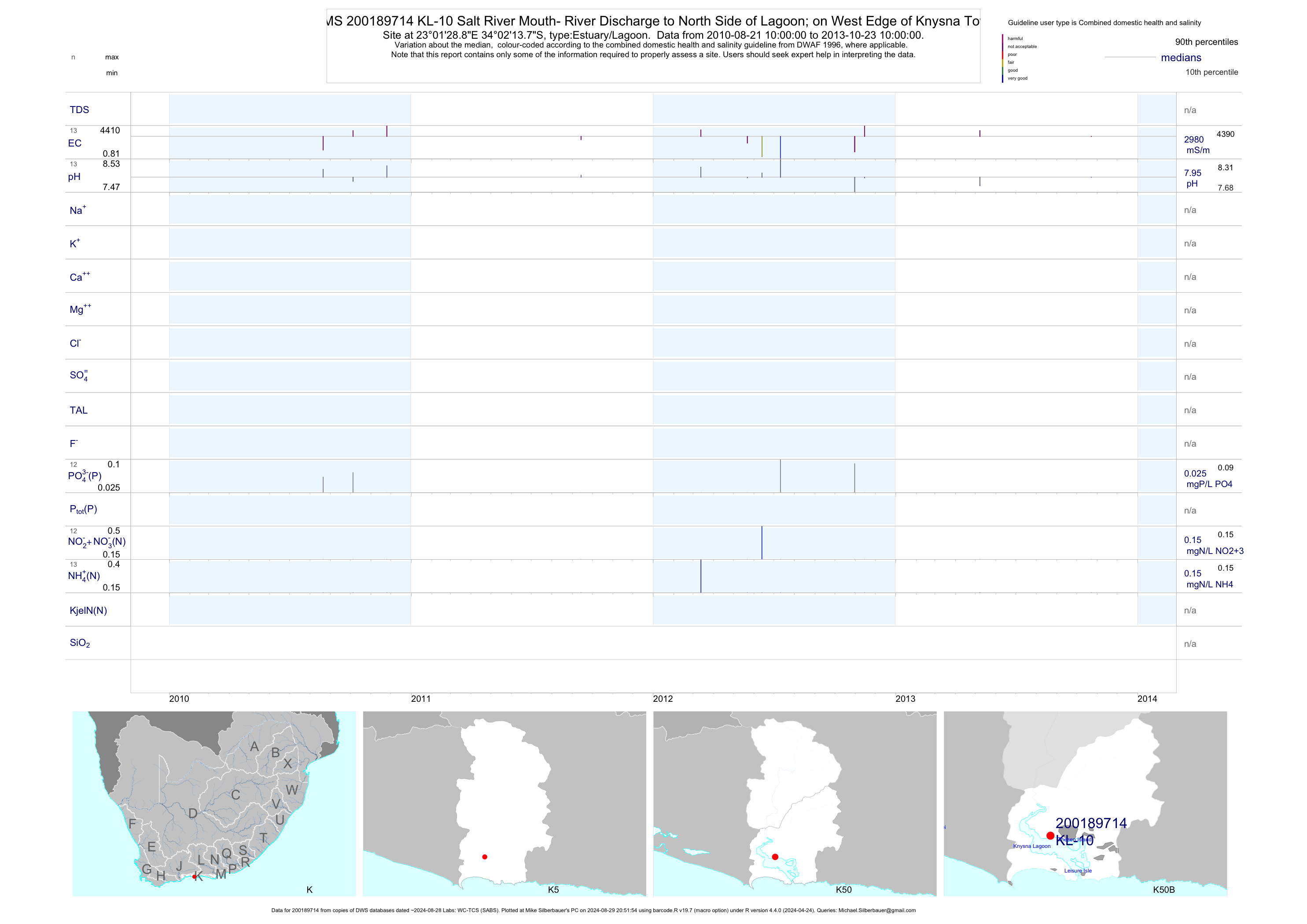
| K50 200189714 | plot | data | Salt River Mouth- River Discharge to North Side of Lagoon; on West Edge of Knysna Town | Estuary/Lagoon | 23 | 2010-08-21 | 2013-10-23 | 2980 | KL-10 | -34.03715 | 23.02468 |
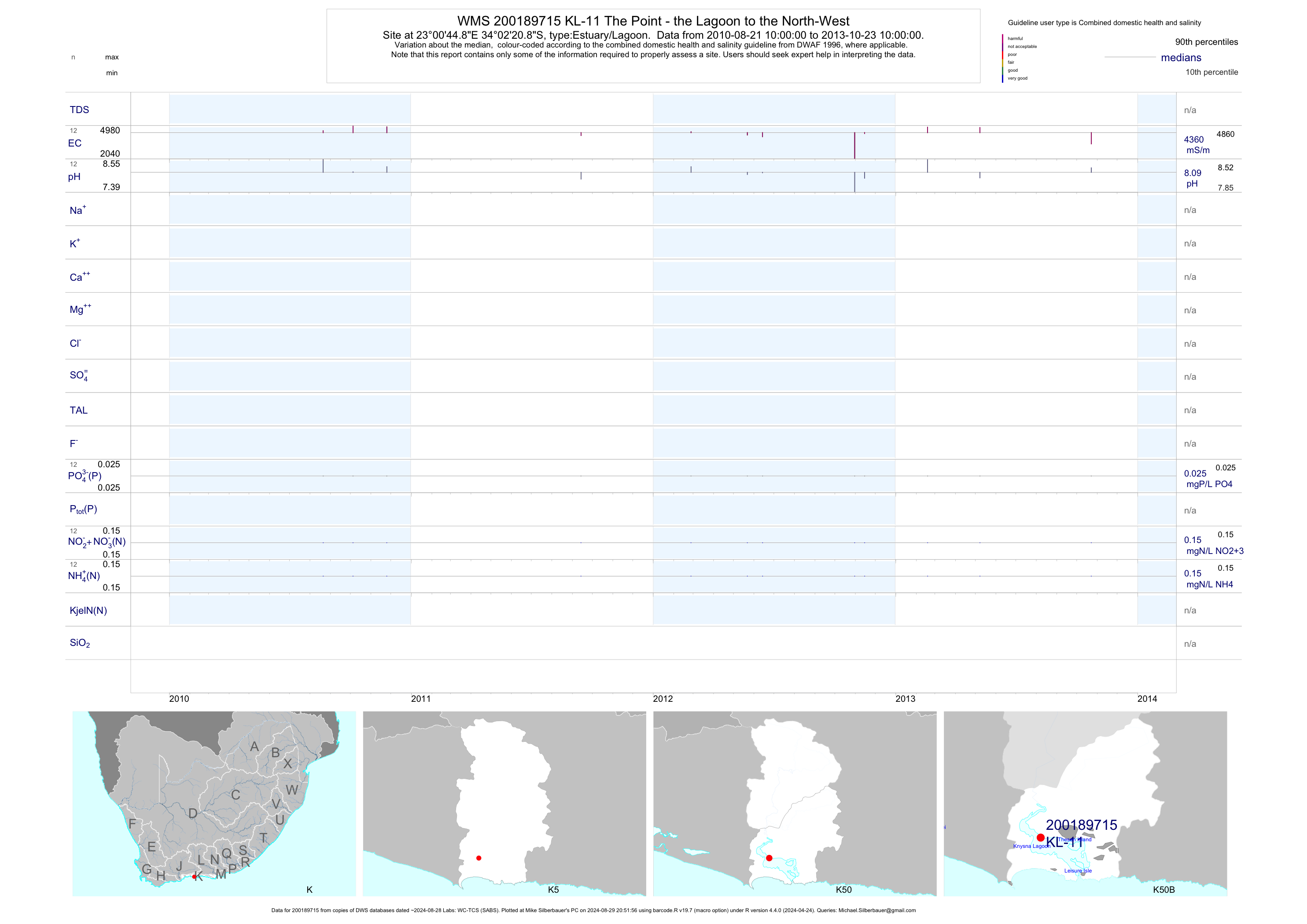
| K50 200189715 | plot | data | The Point - the Lagoon to the North-West | Estuary/Lagoon | 21 | 2010-08-21 | 2013-10-23 | 4355 | KL-11 | -34.03912 | 23.01246 |
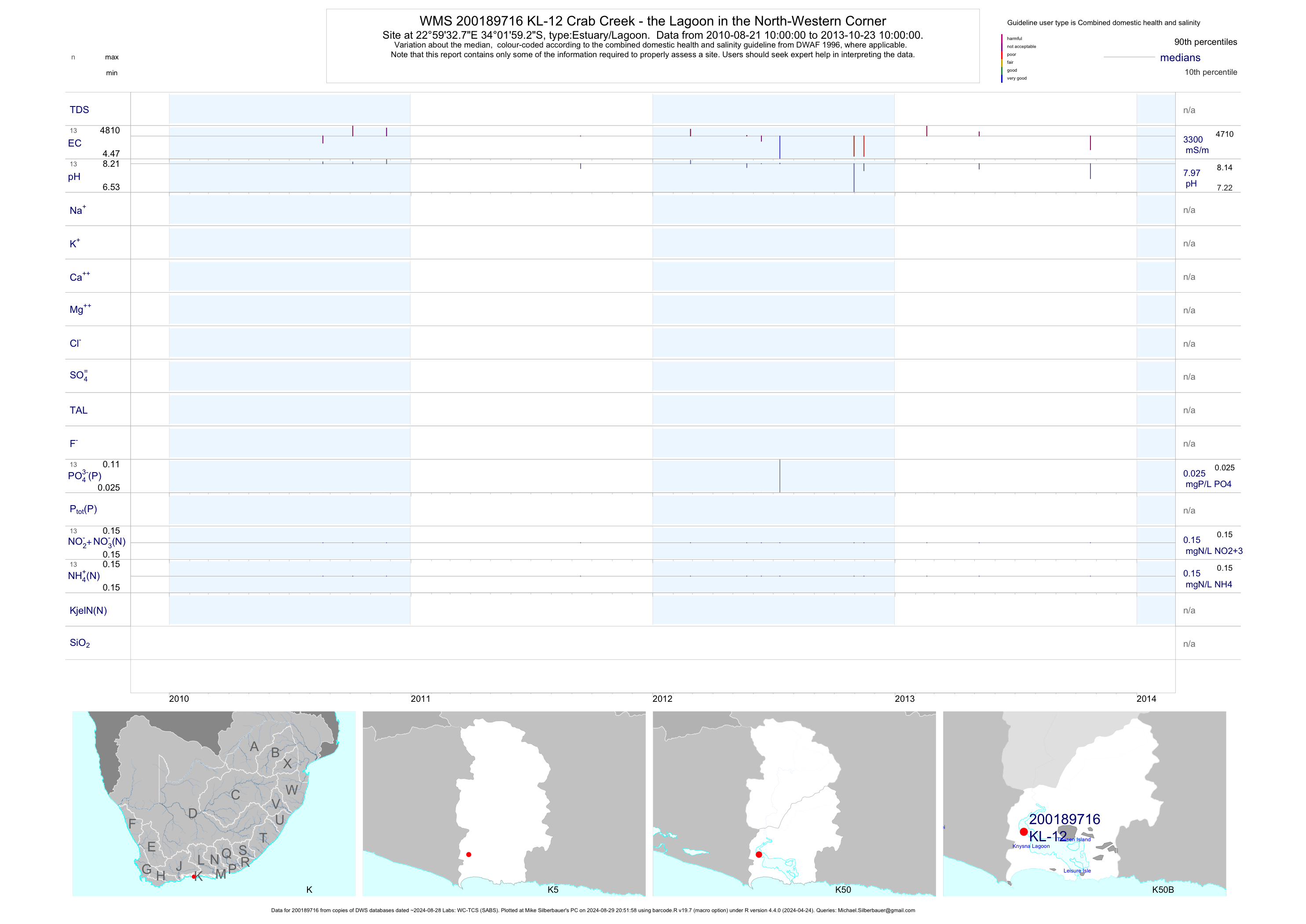
| K50 200189716 | plot | data | Crab Creek - the Lagoon in the North-Western Corner | Estuary/Lagoon | 23 | 2010-08-21 | 2013-10-23 | 3300 | KL-12 | -34.03311 | 22.99244 |
| K50 200189717 | plot | data | Belvidere Bay - the Lagoon to the West | Estuary/Lagoon | 19 | 2010-08-21 | 2013-10-23 | 4520 | KL-13 | -34.04735 | 23.00038 |
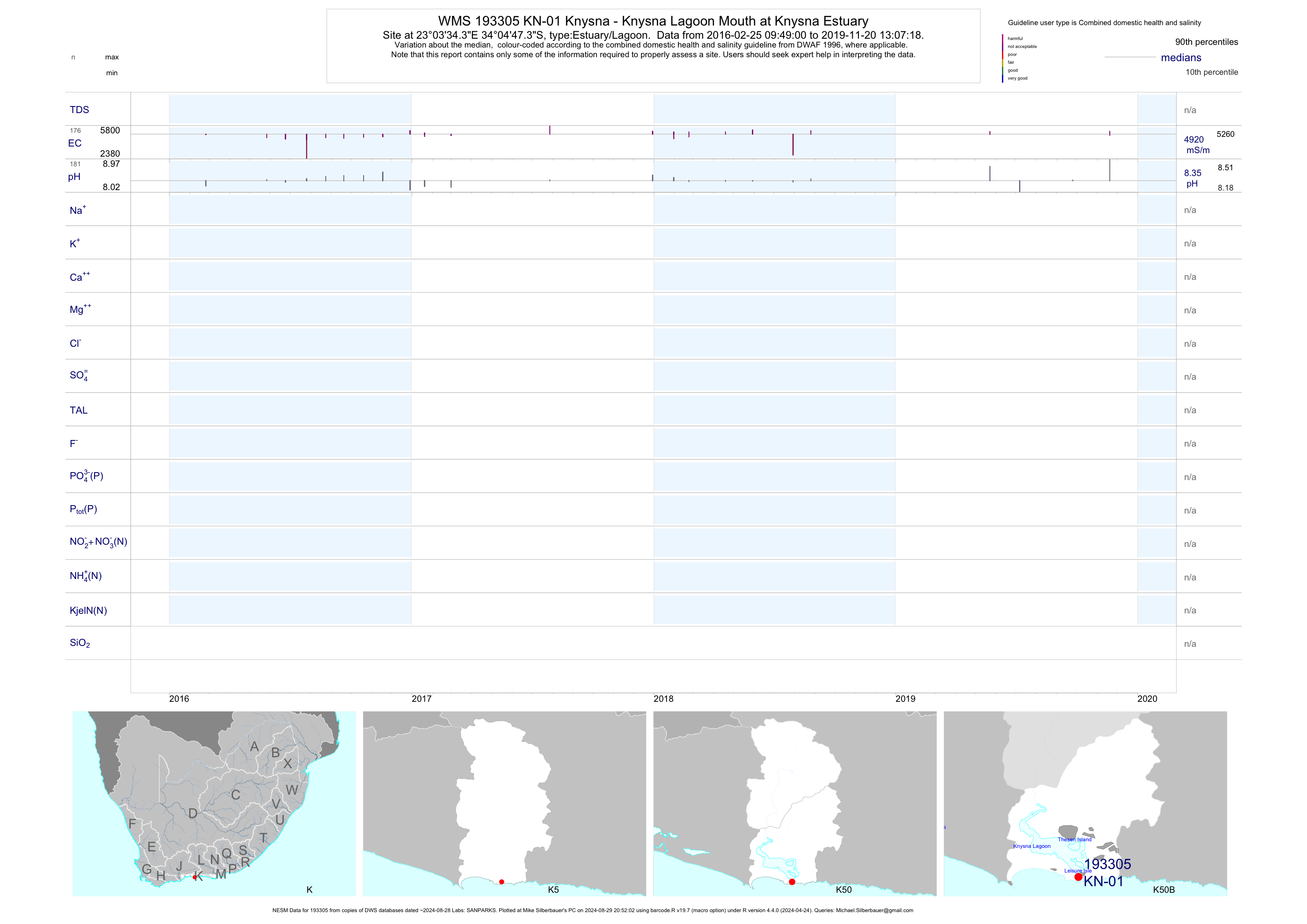
| K50 193305 | plot | data | Knysna - Knysna Lagoon Mouth at Knysna Estuary | Estuary/Lagoon | 25 | 2013-01-21 | 2019-05-23 | 4918 | KN-01 | -34.07981 | 23.05954 |
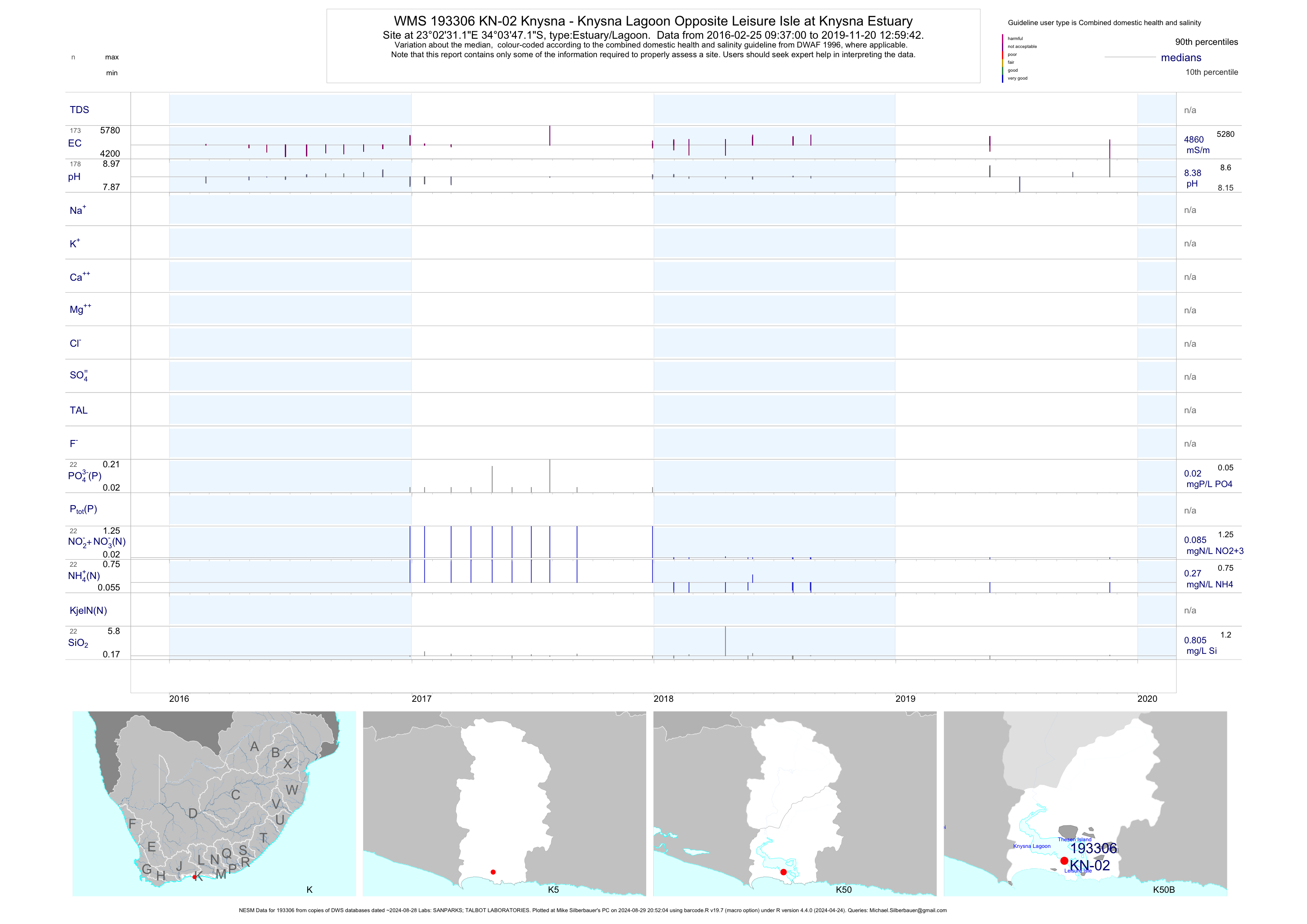
| K50 193306 | plot | data | Knysna - Knysna Lagoon Opposite Leisure Isle at Knysna Estuary | Estuary/Lagoon | 50 | 2013-04-16 | 2019-05-23 | 4858 | KN-02 | -34.06311 | 23.04199 |
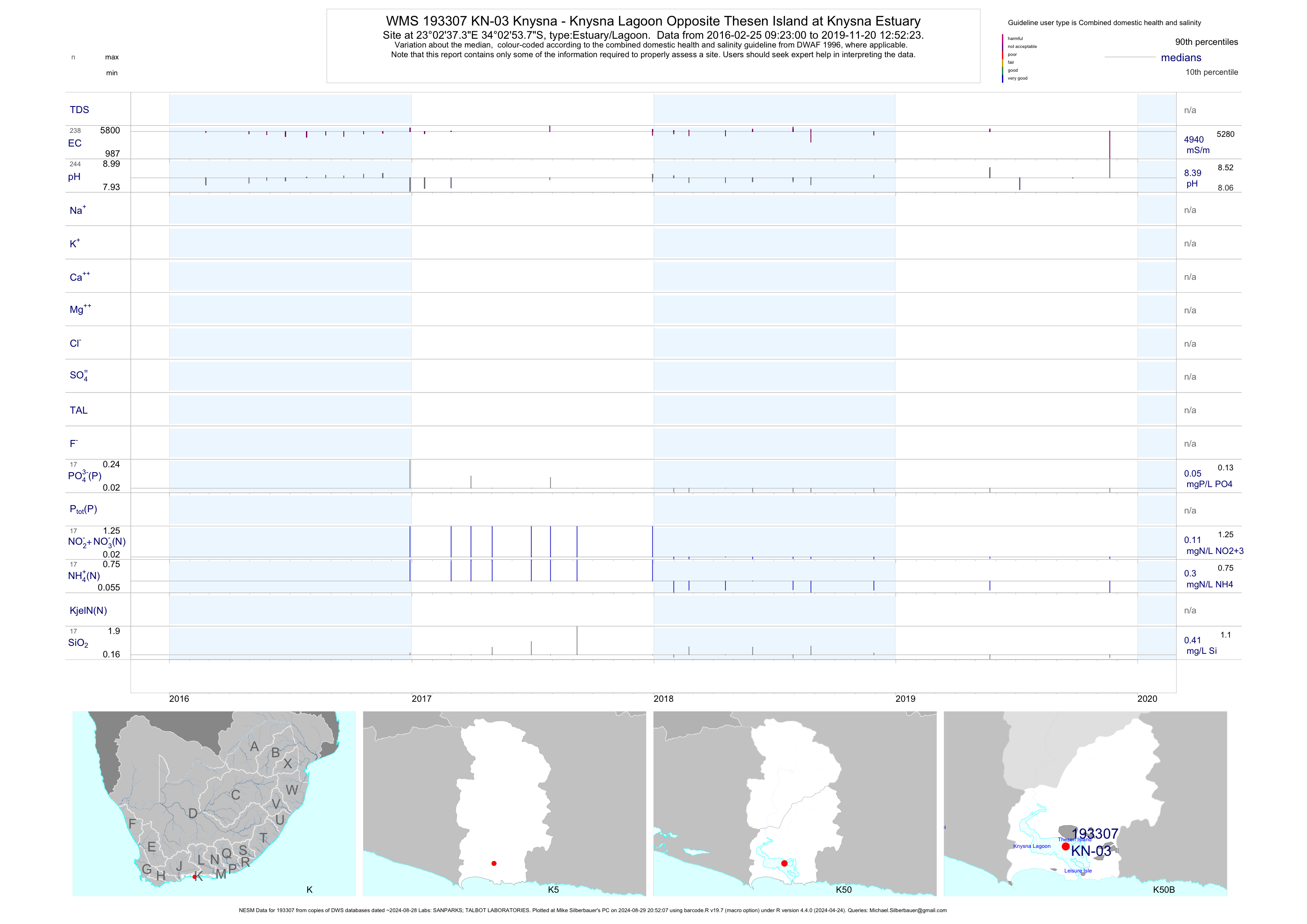
| K50 193307 | plot | data | Knysna - Knysna Lagoon Opposite Thesen Island at Knysna Estuary | Estuary/Lagoon | 50 | 2016-02-25 | 2019-05-23 | 4958 | KN-03 | -34.04827 | 23.04372 |
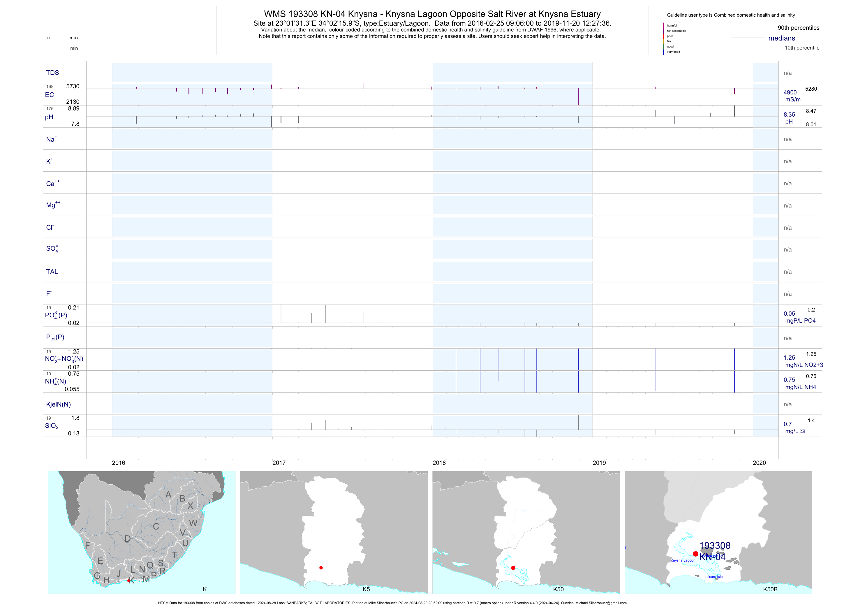
| K50 193308 | plot | data | Knysna - Knysna Lagoon Opposite Salt River at Knysna Estuary | Estuary/Lagoon | 52 | 2013-01-09 | 2019-05-23 | 4942 | KN-04 | -34.03777 | 23.02539 |
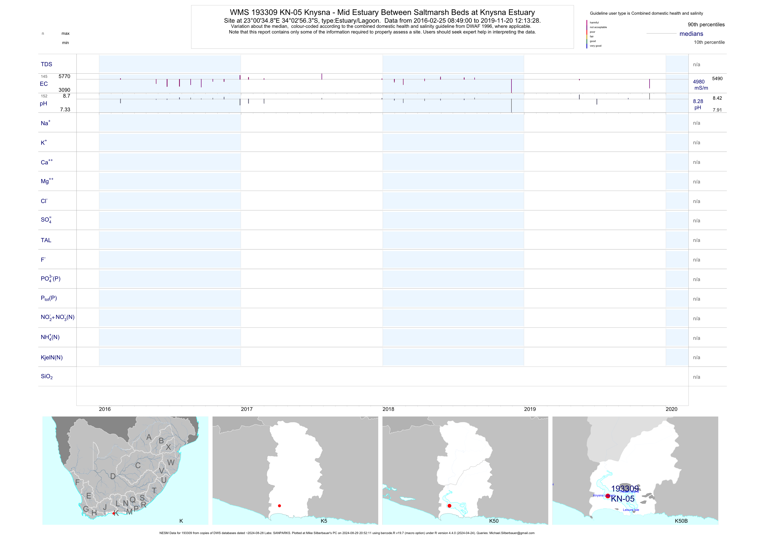
| K50 193309 | plot | data | Knysna - Mid Estuary Between Saltmarsh Beds at Knysna Estuary | Estuary/Lagoon | 25 | 2016-02-25 | 2019-05-23 | 4994 | KN-05 | -34.04899 | 23.00968 |
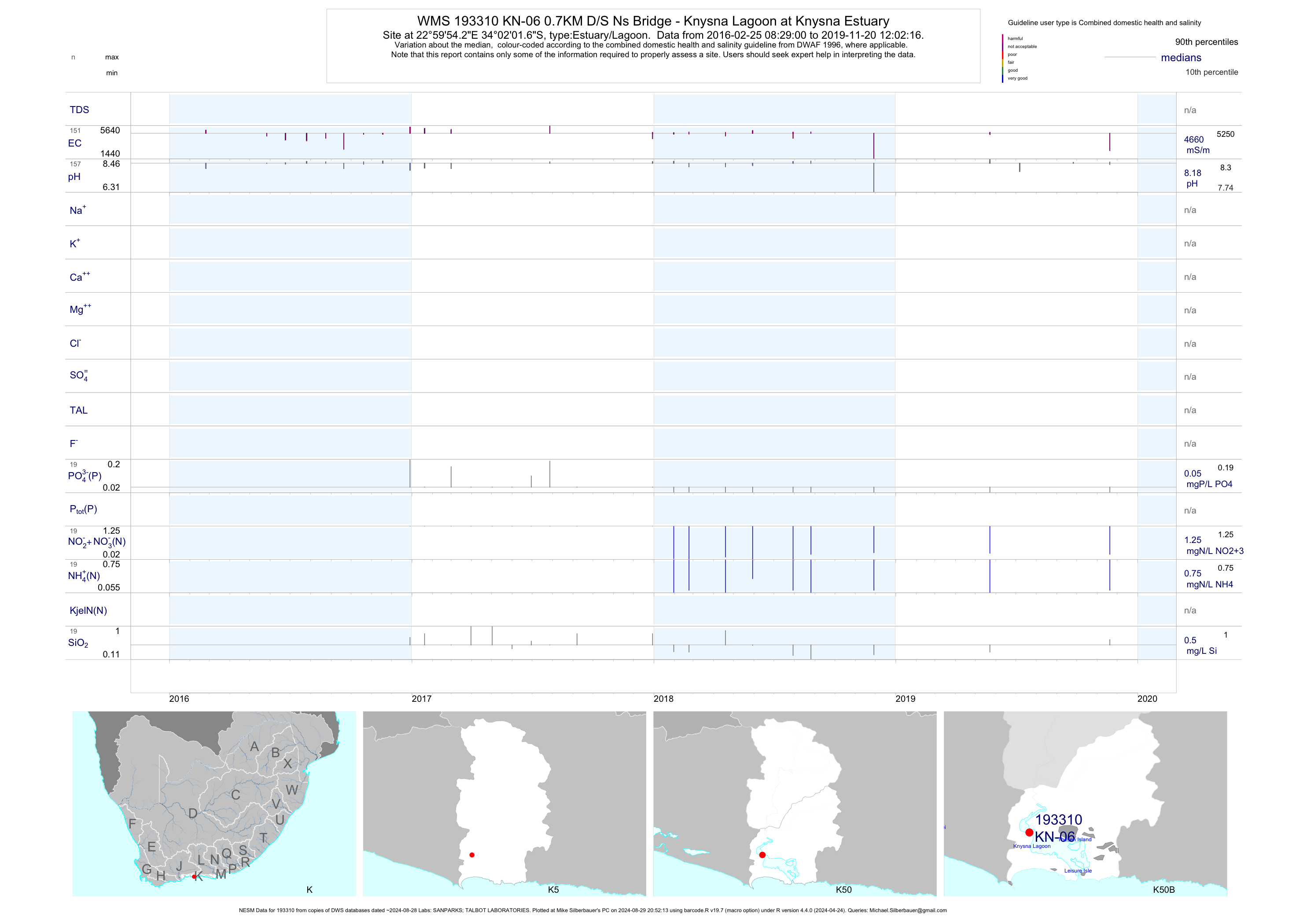
| K50 193310 | plot | data | 0.7KM D/S Ns Bridge - Knysna Lagoon at Knysna Estuary | Estuary/Lagoon | 51 | 2013-01-09 | 2019-05-23 | 4723 | KN-06 | -34.03380 | 22.99840 |
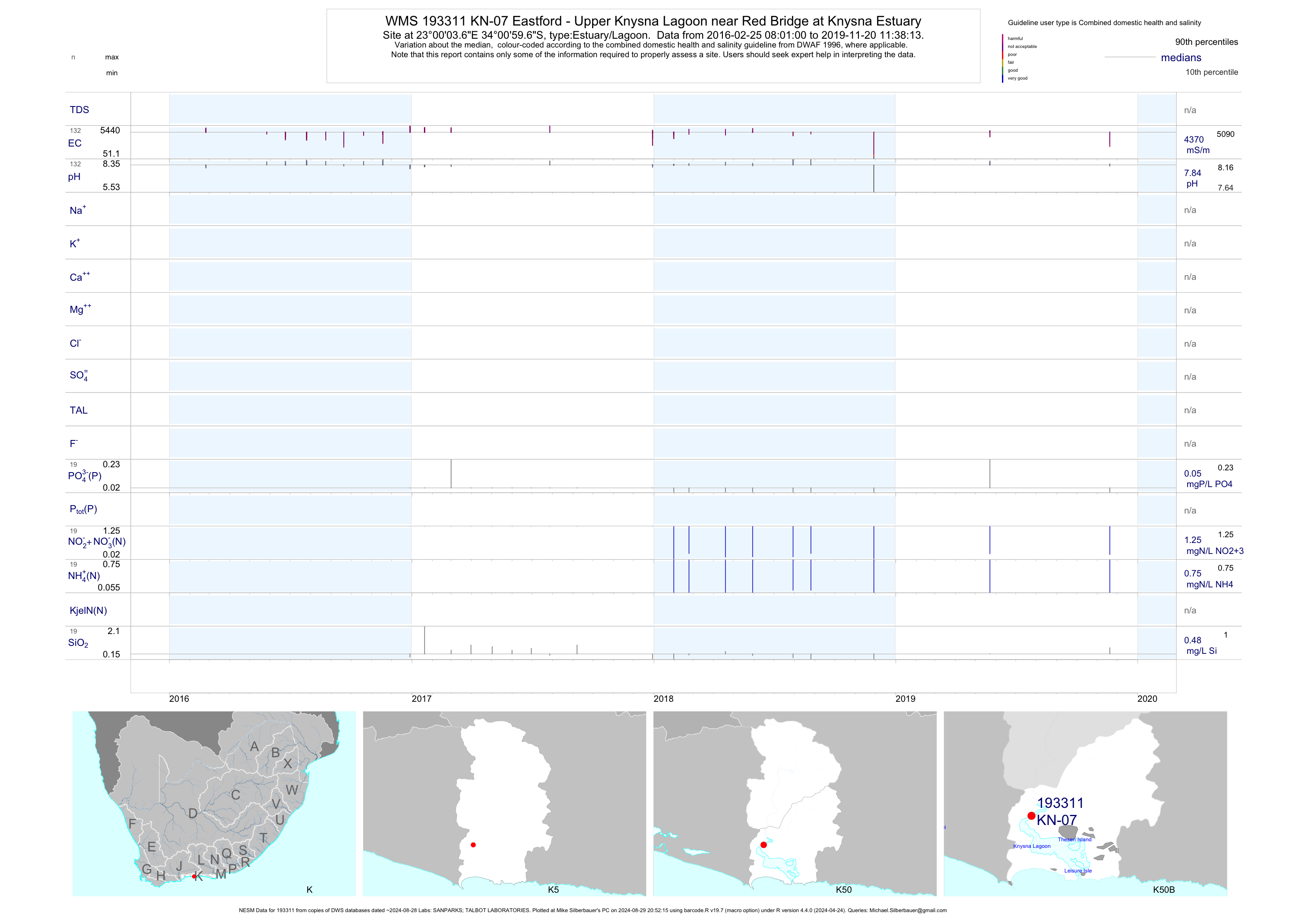
| K50 193311 | plot | data | Eastford - Upper Knysna Lagoon near Red Bridge at Knysna Estuary | Estuary/Lagoon | 49 | 2013-04-16 | 2019-05-23 | 4373 | KN-07 | -34.01658 | 23.00101 |
| K50 193312 | plot | data | Westford at Knysna Estuary | Estuary/Lagoon | 25 | 2016-02-25 | 2019-05-23 | 3284 | KN-08 | -34.00762 | 23.01759 |
| K50 193313 | plot | data | Knysna - Ashmead Channel on Knysna Lagoon at Knysna Estuary | Estuary/Lagoon | 45 | 2013-04-16 | 2019-05-23 | 4937 | KN-09 | -34.04371 | 23.06574 |
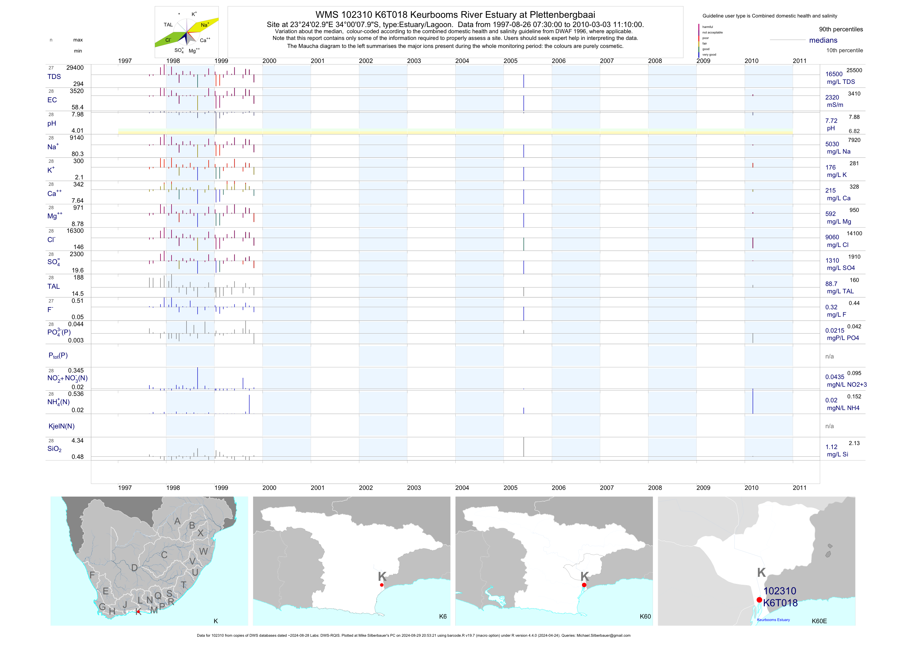
| K60 102310 | plot | data | Keurbooms River Estuary at Plettenbergbaai | Estuary/Lagoon | 30 | 1997-08-26 | 2010-03-03 | 2320 | K6T018 | -34.00222 | 23.40083 |
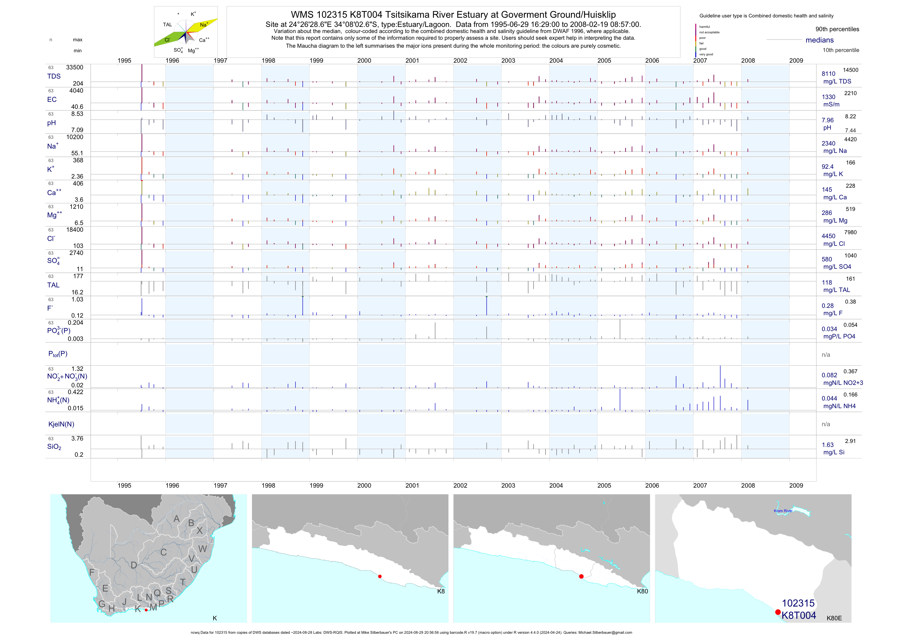
| K80 102315 | plot | data | Tsitsikama River Estuary at Goverment Ground/Huisklip (ncwq) | Estuary/Lagoon | 64 | 1995-06-29 | 2008-02-19 | 1330 | K8T004 | -34.13408 | 24.44128 |
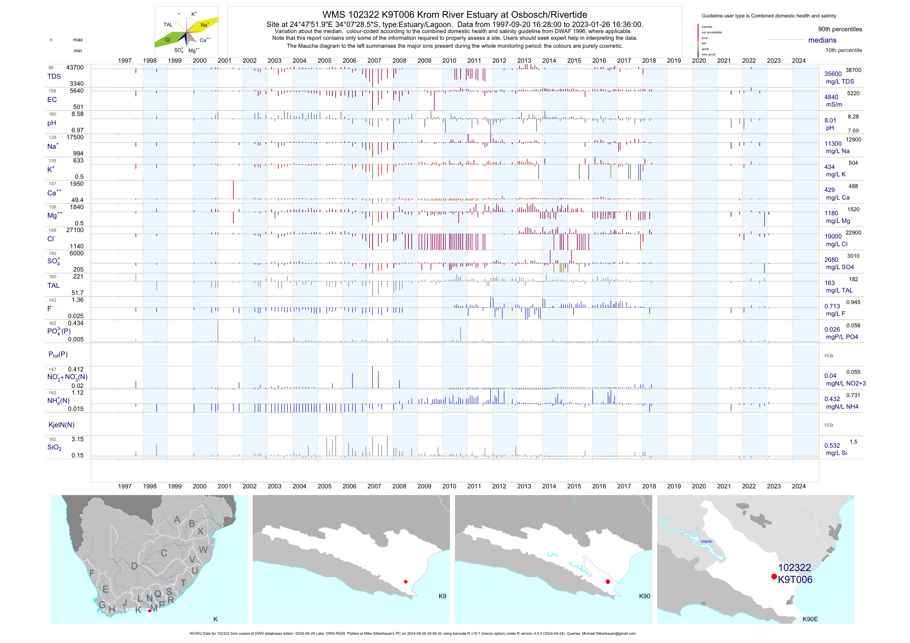
| K90 102322 | plot | data | Krom River Estuary at Osbosch/Rivertide (NCWQ) | Estuary/Lagoon | 156 | 1997-09-20 | 2018-05-17 | 4850 | K9T006 | -34.12458 | 24.79775 |
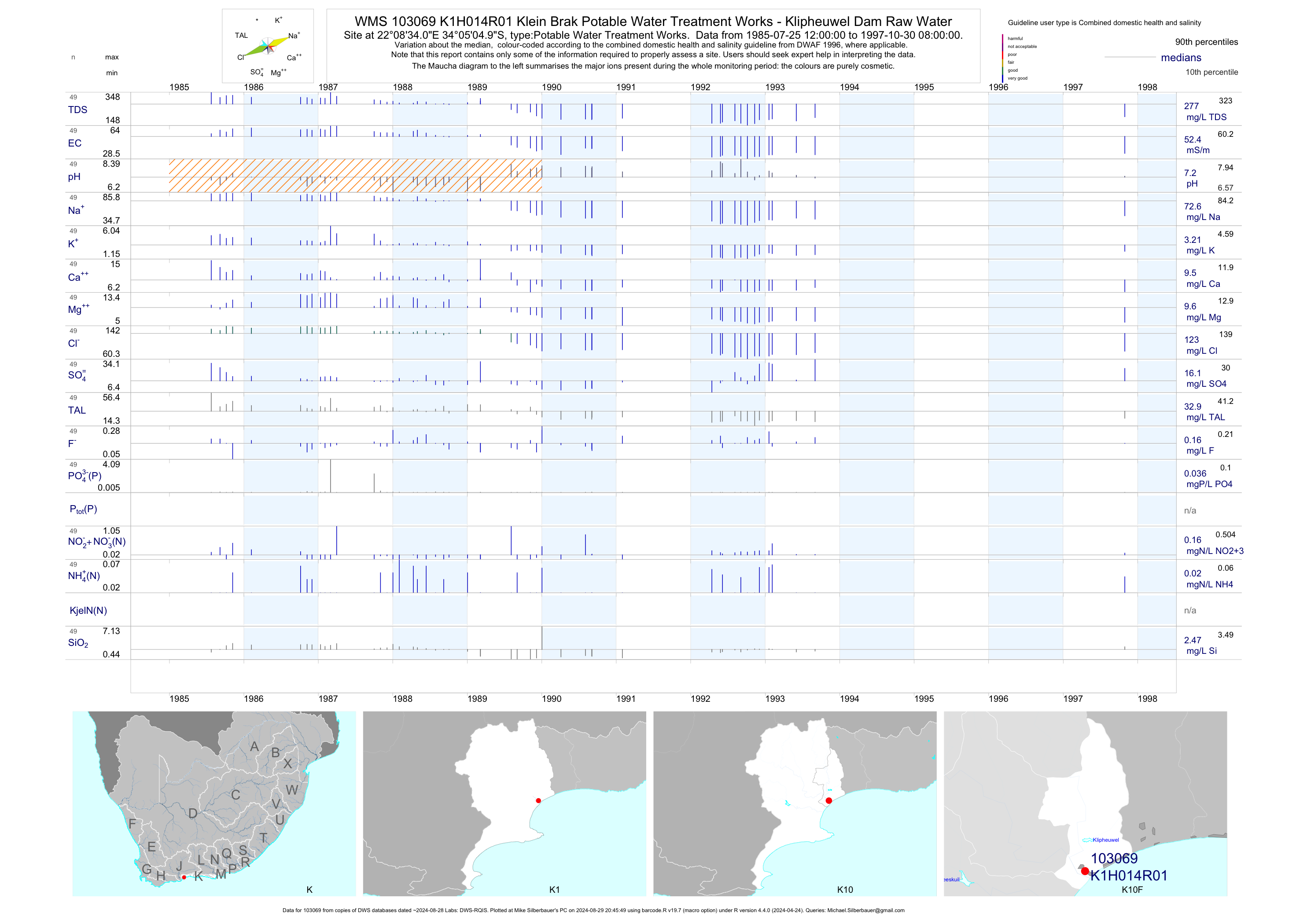
| K10 103069 | plot | data | Klein Brak Potable Water Treatment Works - Klipheuwel Dam Raw Water | Potable Water Treatment Works | 100 | 1985-07-25 | 1997-10-30 | 52 | K1H014 | -34.08472 | 22.14278 |
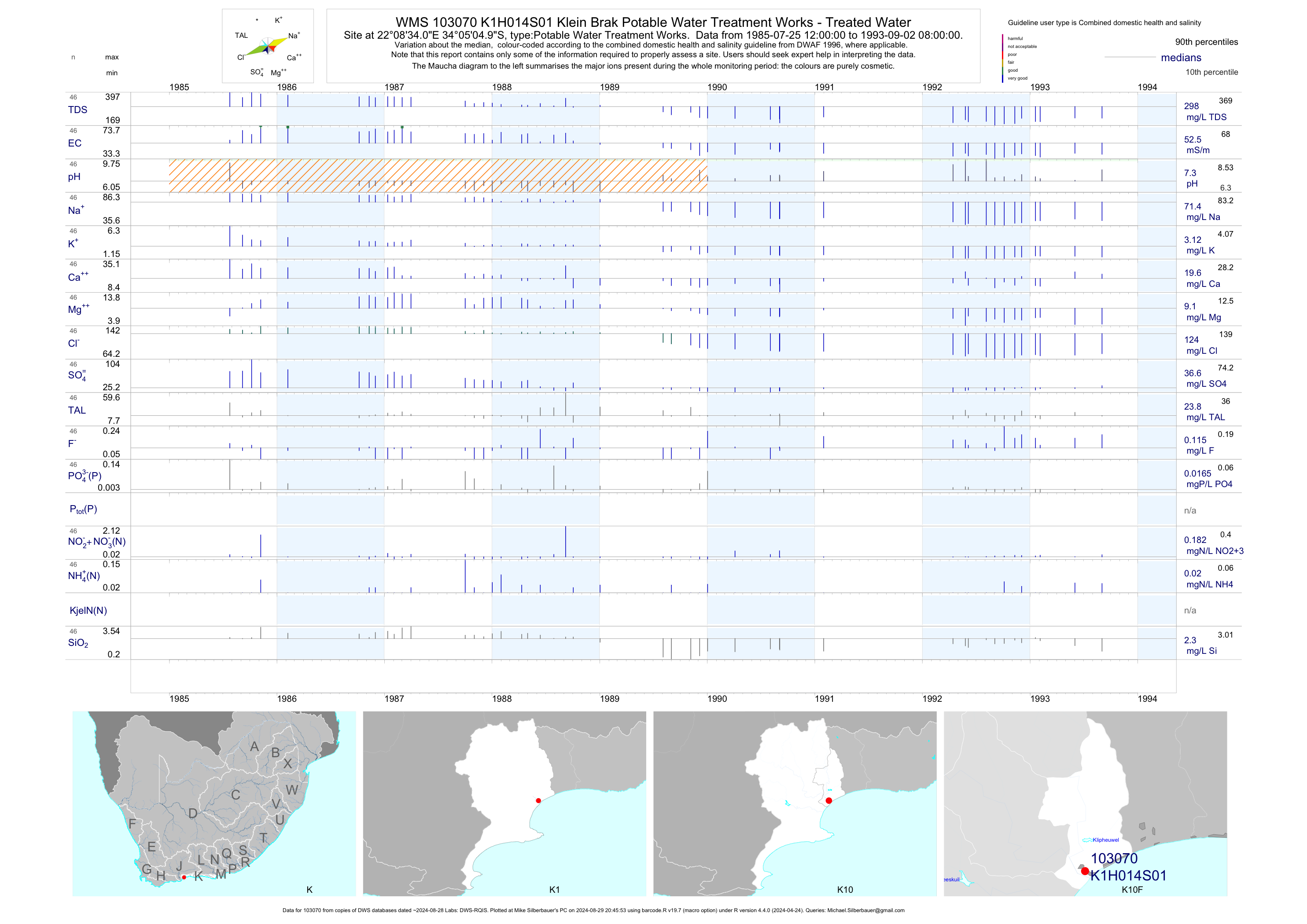
| K10 103070 | plot | data | Klein Brak Potable Water Treatment Works - Treated Water | Potable Water Treatment Works | 105 | 1985-07-25 | 1993-09-02 | 52 | K1H014 | -34.08472 | 22.14278 |
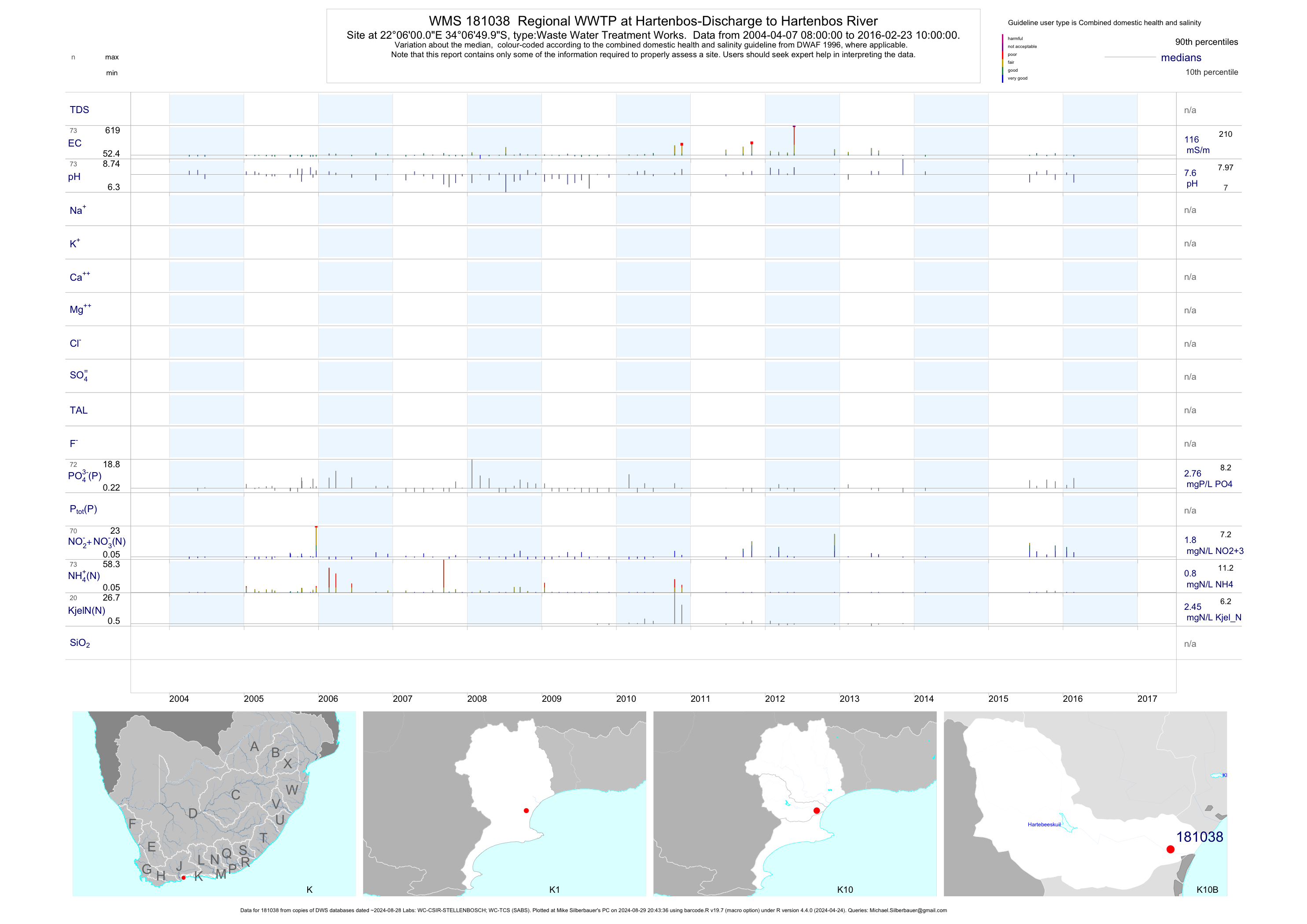
| K10 181038 | plot | data | Regional WWTP at Hartenbos-Discharge to Hartenbos River | Waste Water Treatment Works | 270 | 1999-01-06 | 2016-02-23 | 107 | 181038 | -34.11389 | 22.10000 |
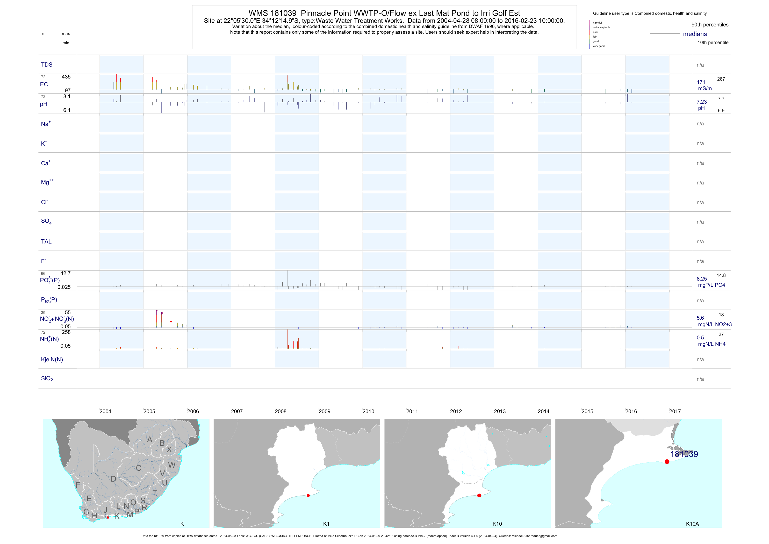
| K10 181039 | plot | data | Pinnacle Point WWTP-O/Flow ex Last Mat Pond to Irri Golf Est | Waste Water Treatment Works | 196 | 1999-01-13 | 2016-02-23 | 206 | 181039 | -34.20417 | 22.09167 |
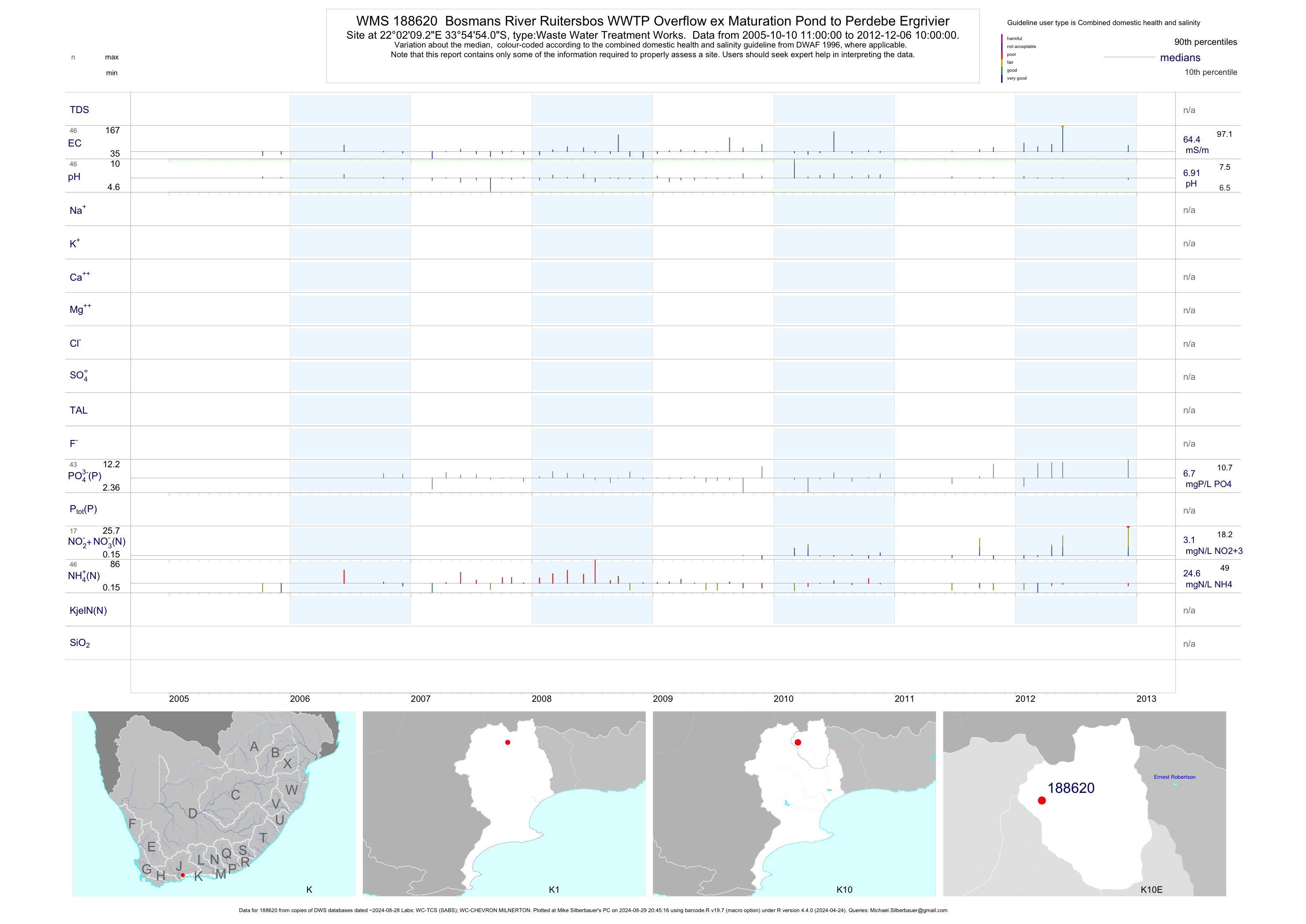
| K10 188620 | plot | data | Bosmans River Ruitersbos WWTP Overflow ex Maturation Pond to Perdebe Ergrivier | Waste Water Treatment Works | 41 | 2005-10-10 | 2011-09-14 | 64 | 188620 | -33.91500 | 22.03590 |
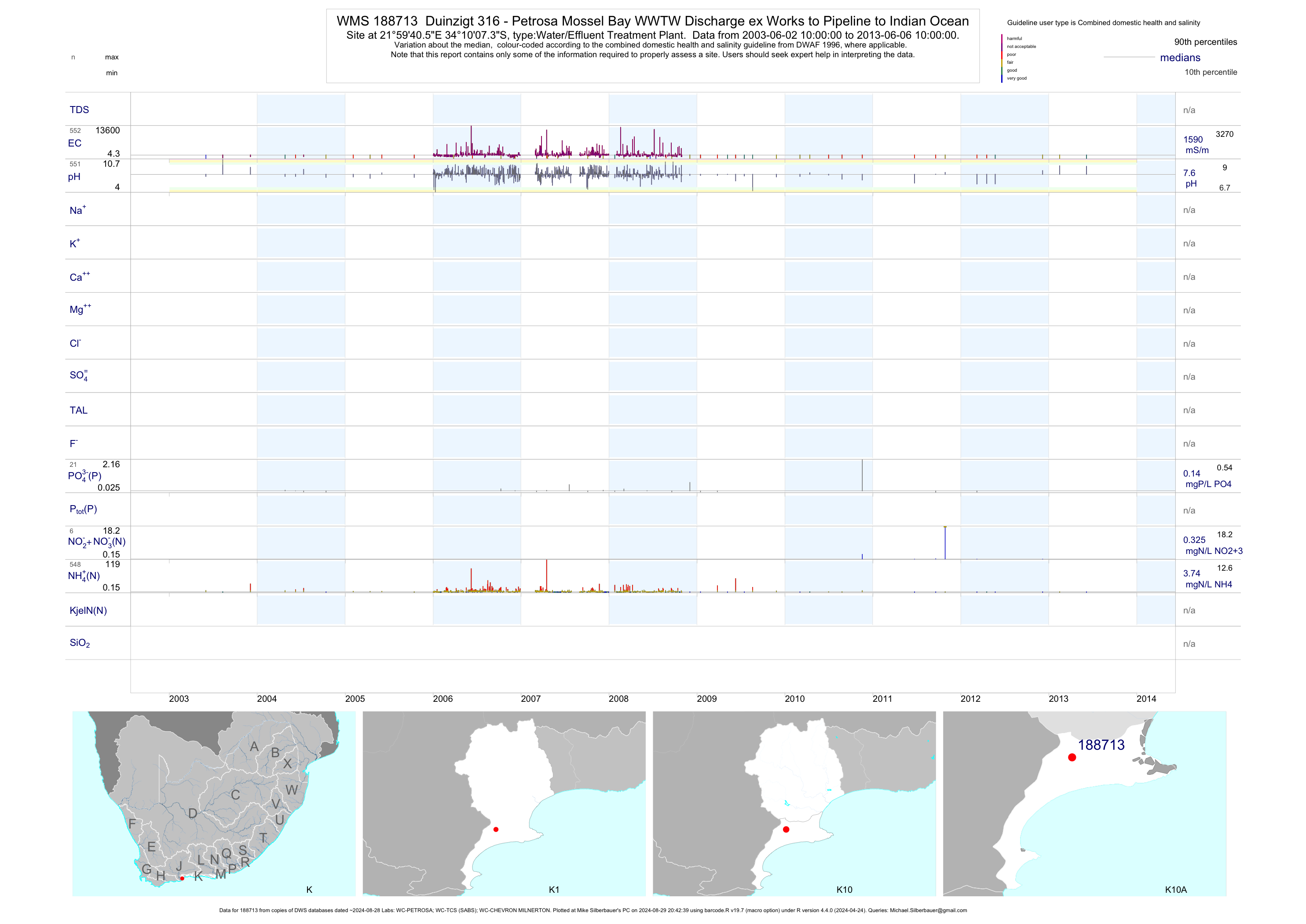
| K10 188713 | plot | data | Duinzigt 316 - Petrosa Mossel Bay WWTW Discharge ex Works to Pipeline to Indian Ocean | Water/Effluent Treatment Plant | 553 | 2003-06-02 | 2013-06-06 | 1586 | 188713 | -34.16870 | 21.99460 |
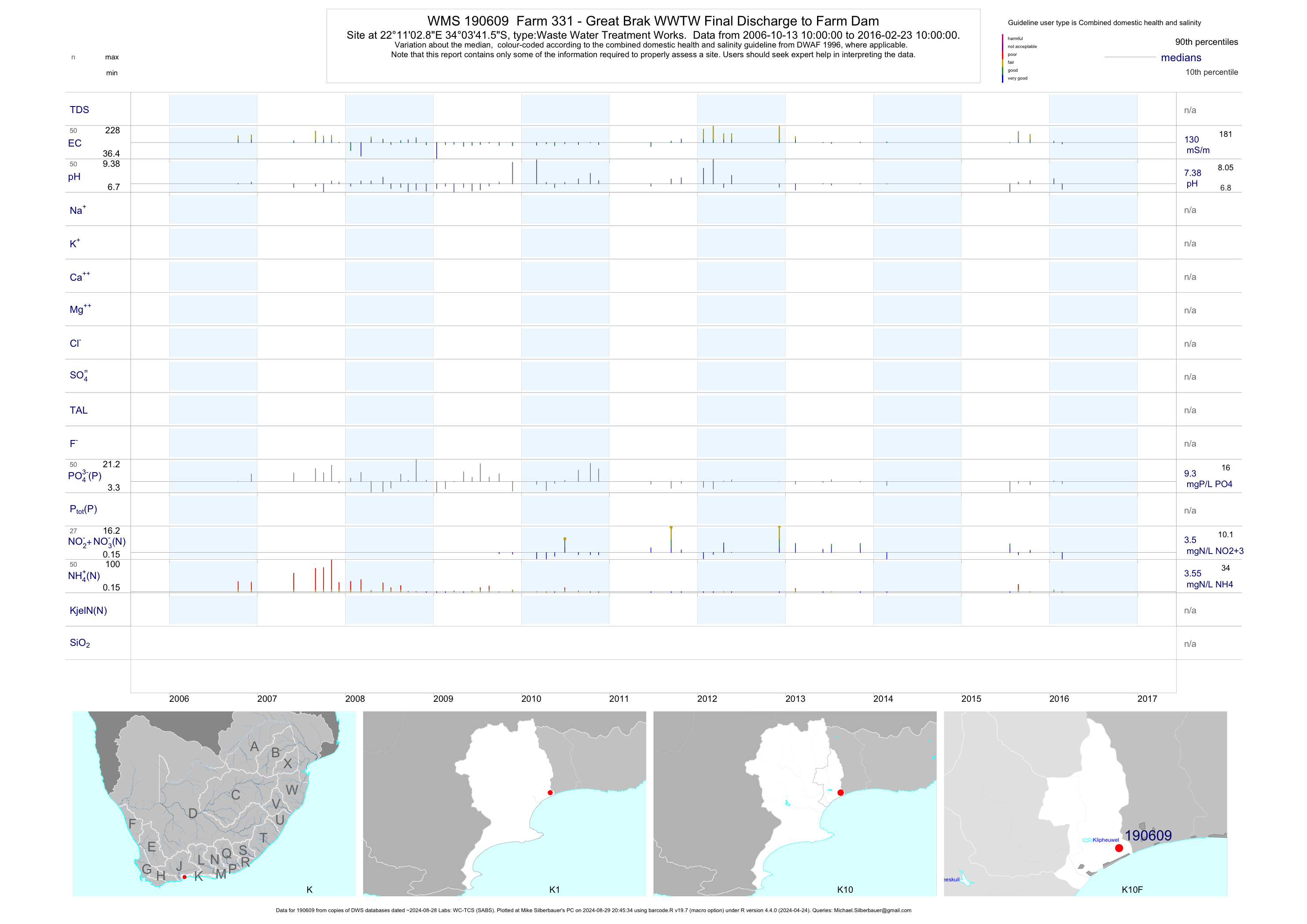
| K10 190609 | plot | data | Farm 331 - Great Brak WWTW Final Discharge to Farm Dam | Waste Water Treatment Works | 50 | 2006-10-13 | 2016-02-23 | 130 | 190609 | -34.06155 | 22.18413 |
| K10 1000010276 | plot | data | Friemersheim a-New WWTP-ex Combo Plant to Trib of Moordkuil | Waste Water Treatment Works | 63 | 2000-01-13 | 2009-11-25 | 74 | 1-10276 | -33.95760 | 22.14350 |
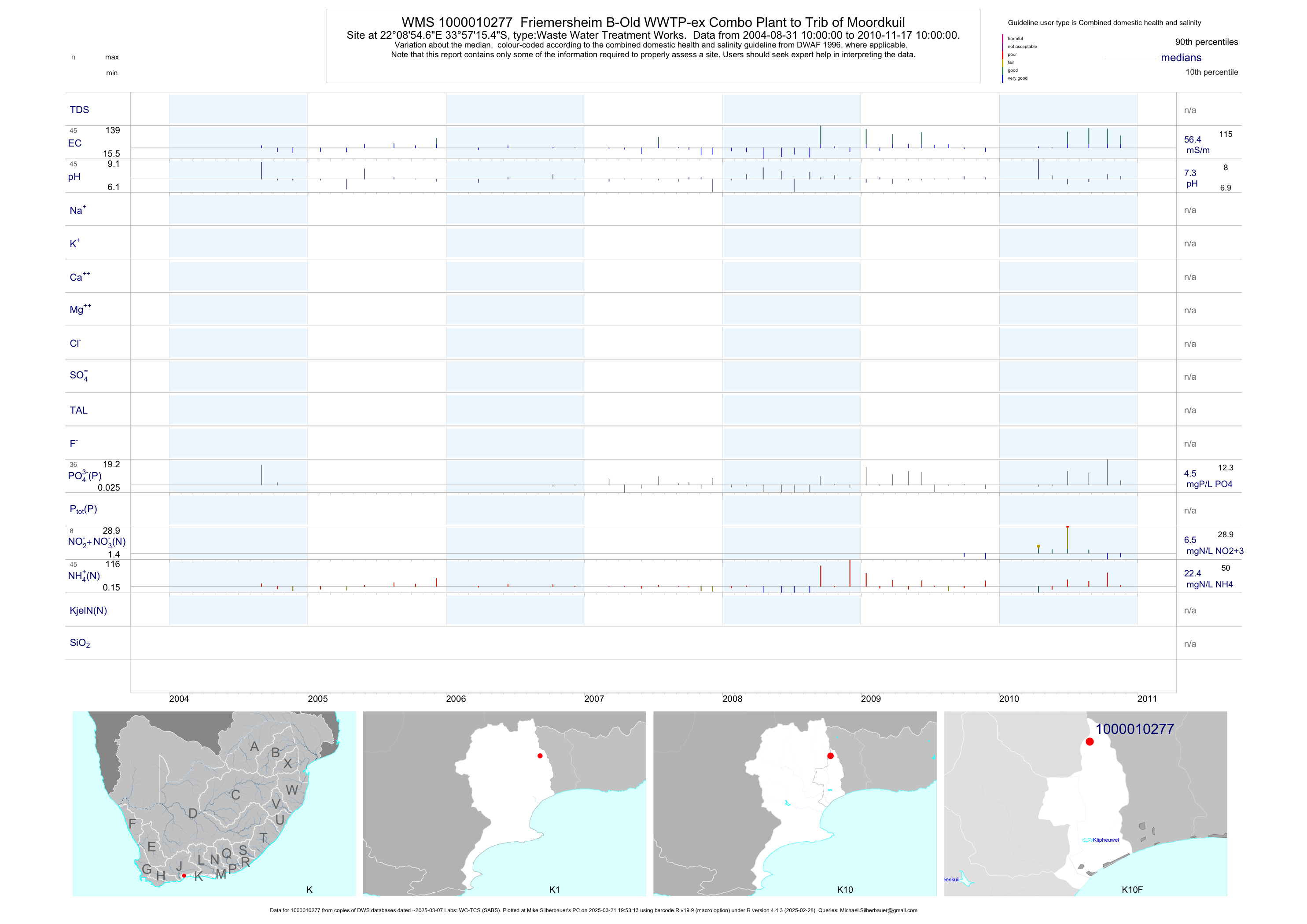
| K10 1000010277 | plot | data | Friemersheim B-Old WWTP-ex Combo Plant to Trib of Moordkuil | Waste Water Treatment Works | 62 | 2000-01-13 | 2009-11-25 | 54 | 1-10277 | -33.95430 | 22.14850 |
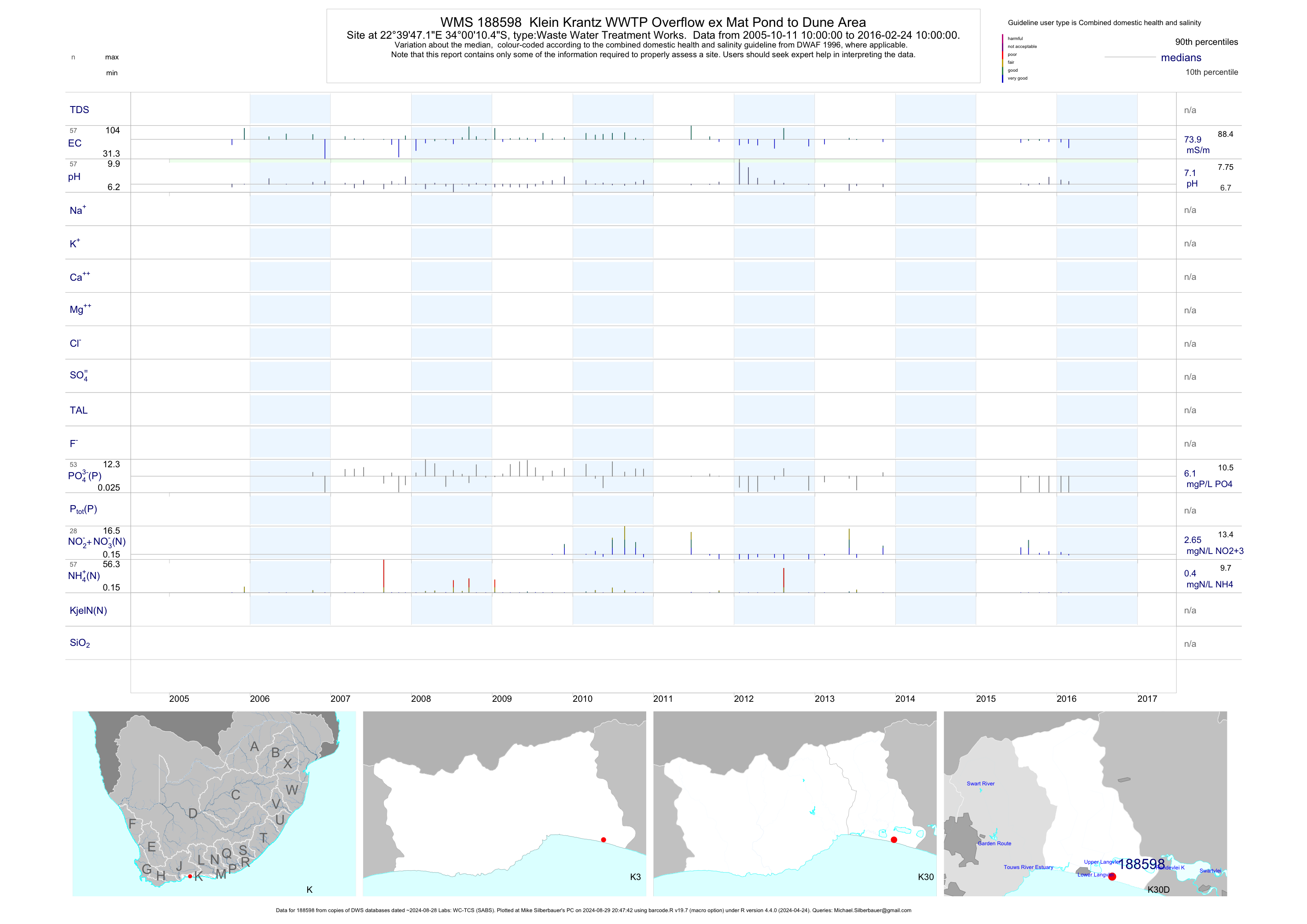
| K30 188598 | plot | data | Klein Krantz WWTP Overflow ex Mat Pond to Dune Area | Waste Water Treatment Works | 57 | 2005-10-11 | 2016-02-24 | 74 | 188598 | -34.00290 | 22.66310 |
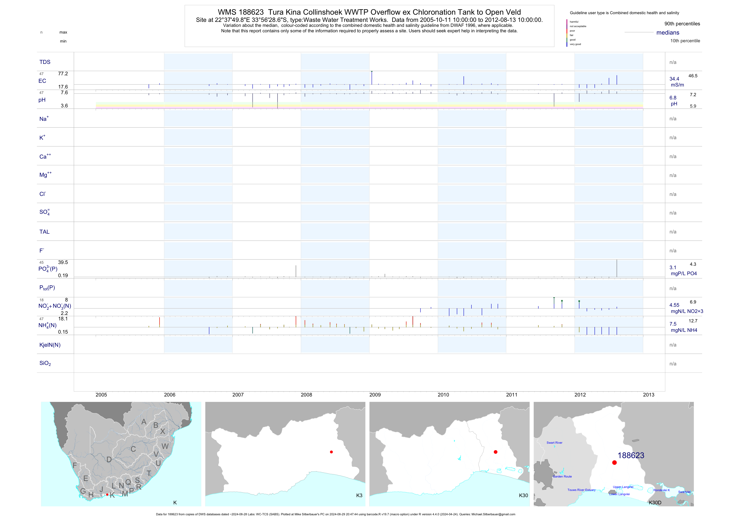
| K30 188623 | plot | data | Tura Kina Collinshoek WWTP Overflow ex Chloronation Tank to Open Veld | Waste Water Treatment Works | 32 | 2005-10-11 | 2010-03-02 | 34 | 188623 | -33.94130 | 22.63050 |
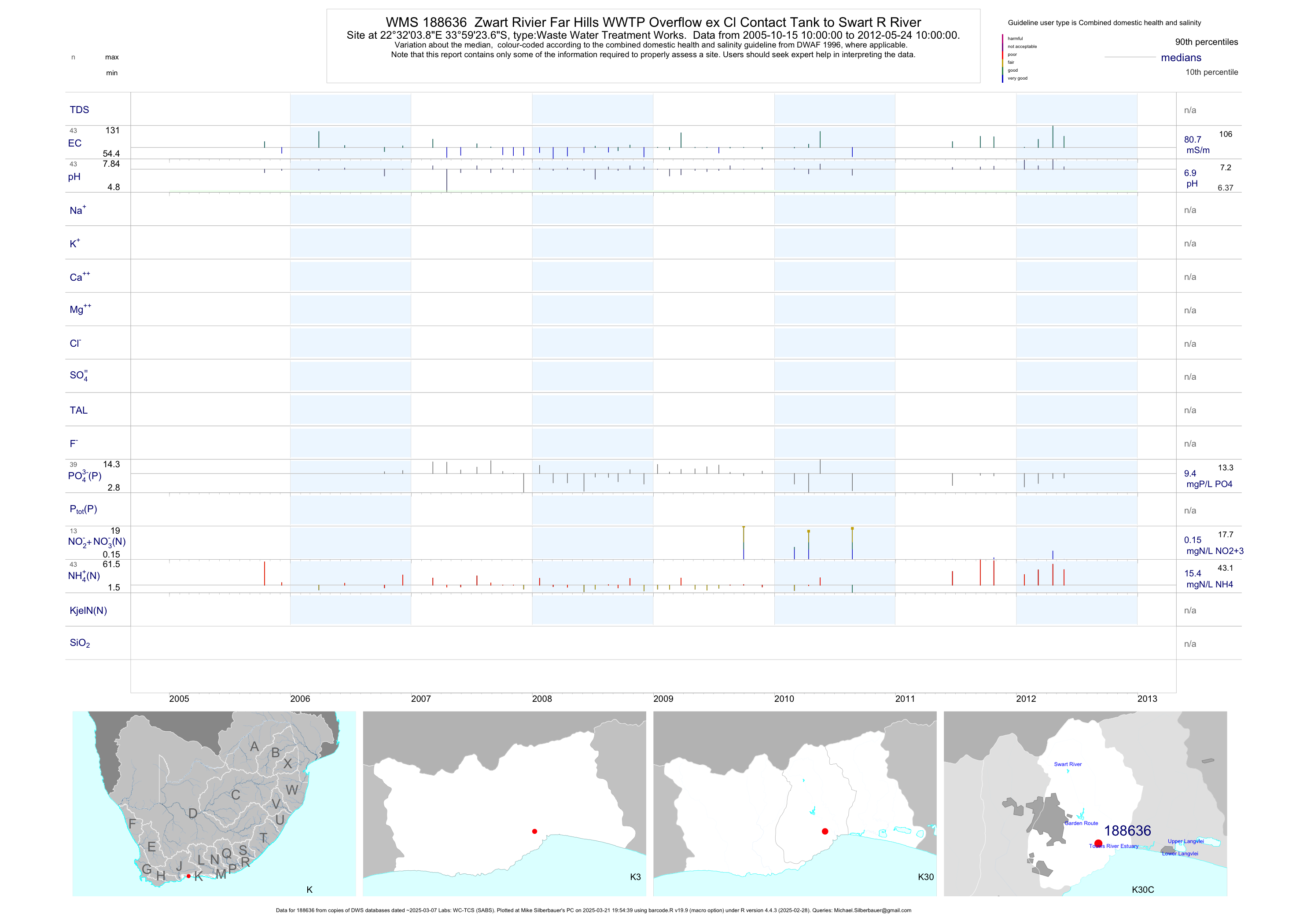
| K30 188636 | plot | data | Zwart Rivier Far Hills WWTP Overflow ex Cl Contact Tank to Swart R River | Waste Water Treatment Works | 33 | 2005-10-15 | 2010-03-02 | 81 | 188636 | -33.98990 | 22.53440 |
| K30 188643 | plot | data | Farm 149 Saasveld WWTP Overflow ex Cl Contact Tank to Swart River R | Waste Water Treatment Works | 32 | 2005-10-11 | 2010-03-02 | 55 | 188643 | -33.96040 | 22.53020 |
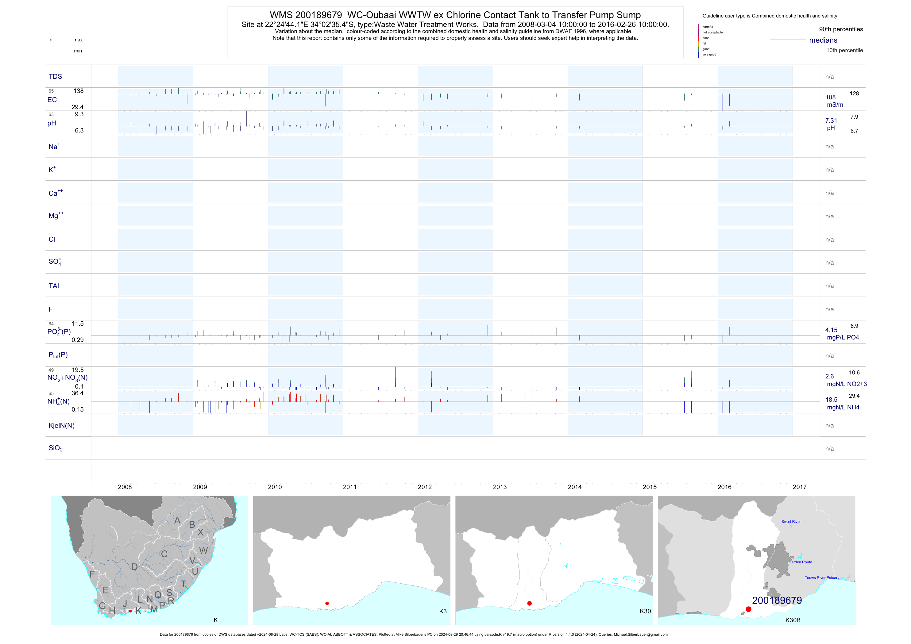
| K30 200189679 | plot | data | WC-Oubaai WWTW ex Chlorine Contact Tank to Transfer Pump Sump | Waste Water Treatment Works | 65 | 2008-03-04 | 2016-02-26 | 108 | 200189679 | -34.04318 | 22.41228 |
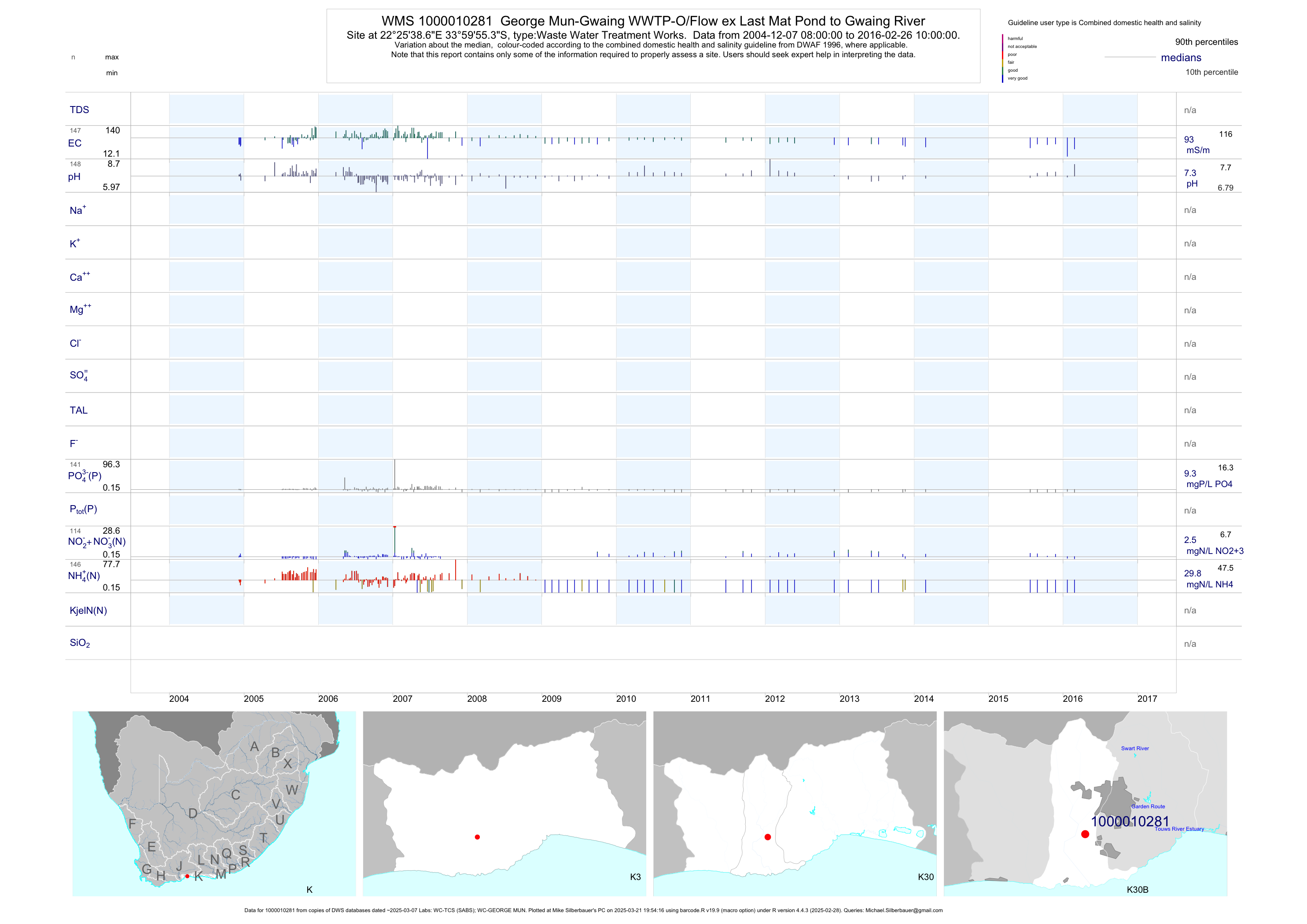
| K30 1000010281 | plot | data | George Mun-Gwaing WWTP-O/Flow ex Last Mat Pond to Gwaing River | Waste Water Treatment Works | 708 | 1990-10-31 | 2016-02-26 | 80 | 1-10281 | -33.99870 | 22.42740 |
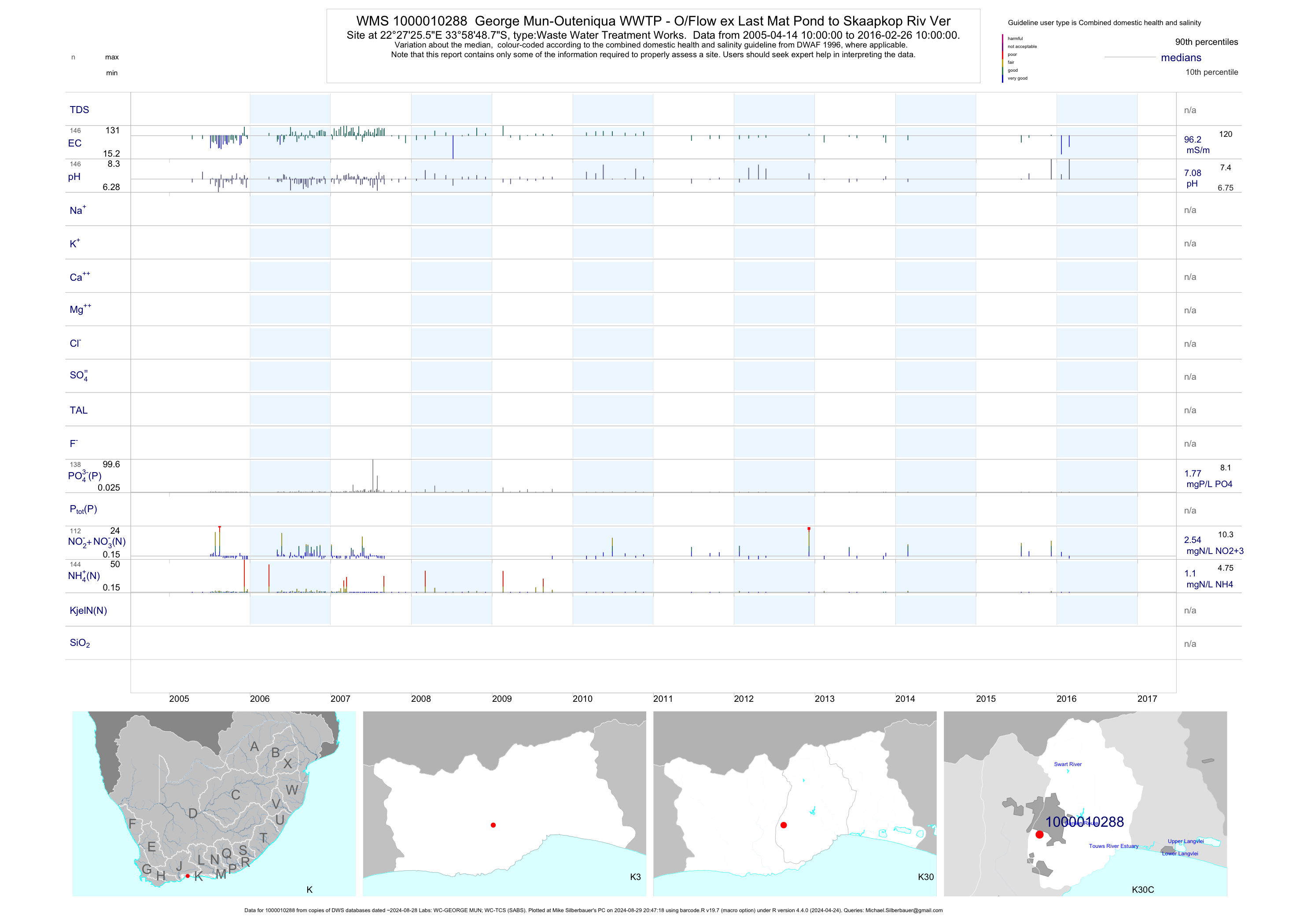
| K30 1000010288 | plot | data | George Mun-Outeniqua WWTP - O/Flow ex Last Mat Pond to Skaapkop Riv Ver | Waste Water Treatment Works | 348 | 2000-01-13 | 2016-02-26 | 83 | 1-10288 | -33.98020 | 22.45710 |
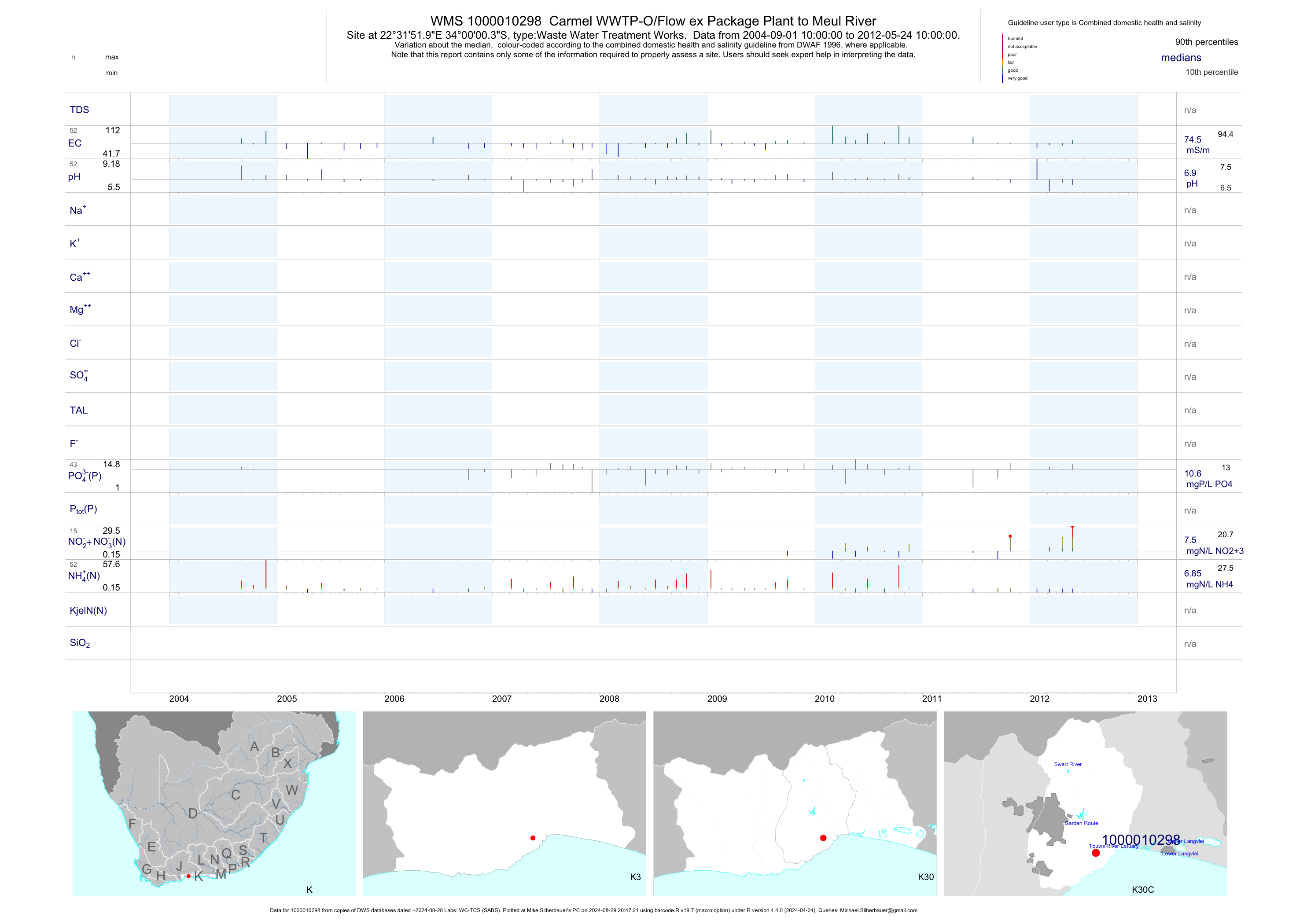
| K30 1000010298 | plot | data | Carmel WWTP-O/Flow ex Package Plant to Meul River | Waste Water Treatment Works | 39 | 2004-09-01 | 2010-03-02 | 74 | 1-10298 | -34.00010 | 22.53110 |
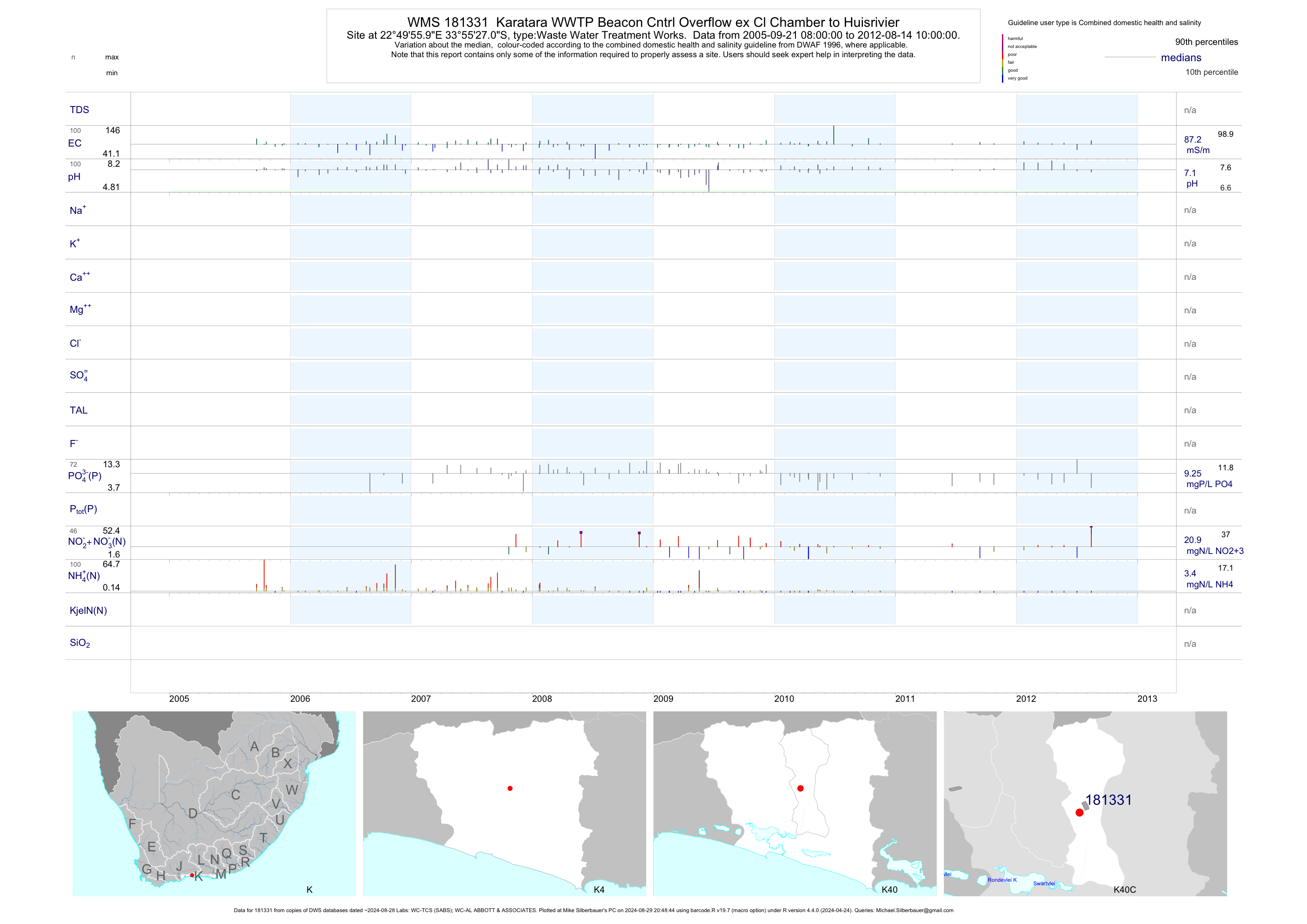
| K40 181331 | plot | data | Karatara WWTP Beacon Cntrl Overflow ex Cl Chamber to Huisrivier | Waste Water Treatment Works | 333 | 1988-10-26 | 2012-08-14 | 86 | 181331 | -33.92417 | 22.83222 |
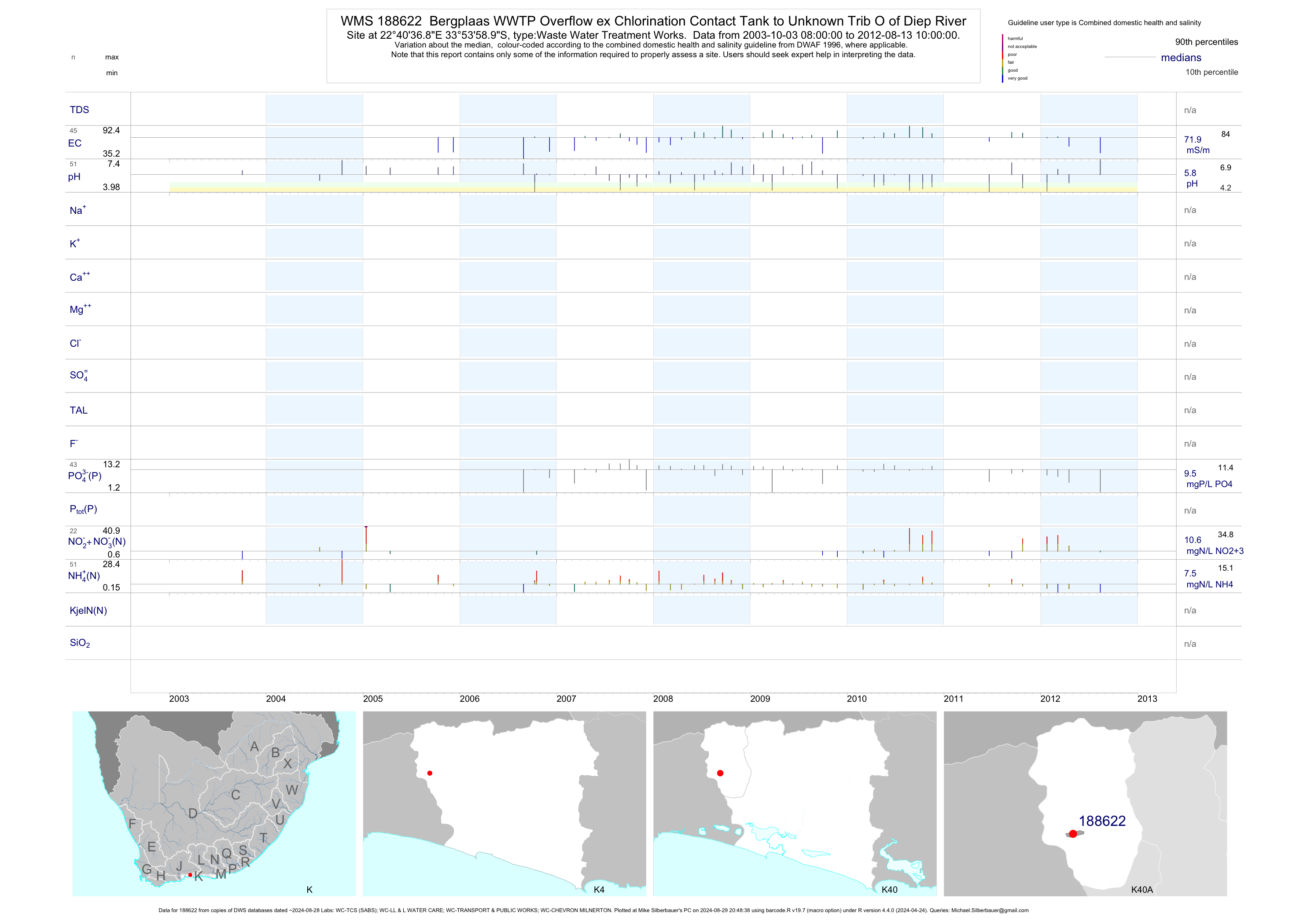
| K40 188622 | plot | data | Bergplaas WWTP Overflow ex Chlorination Contact Tank to Unknown Trib O of Diep River | Waste Water Treatment Works | 38 | 2003-10-03 | 2010-03-02 | 72 | 188622 | -33.89970 | 22.67690 |
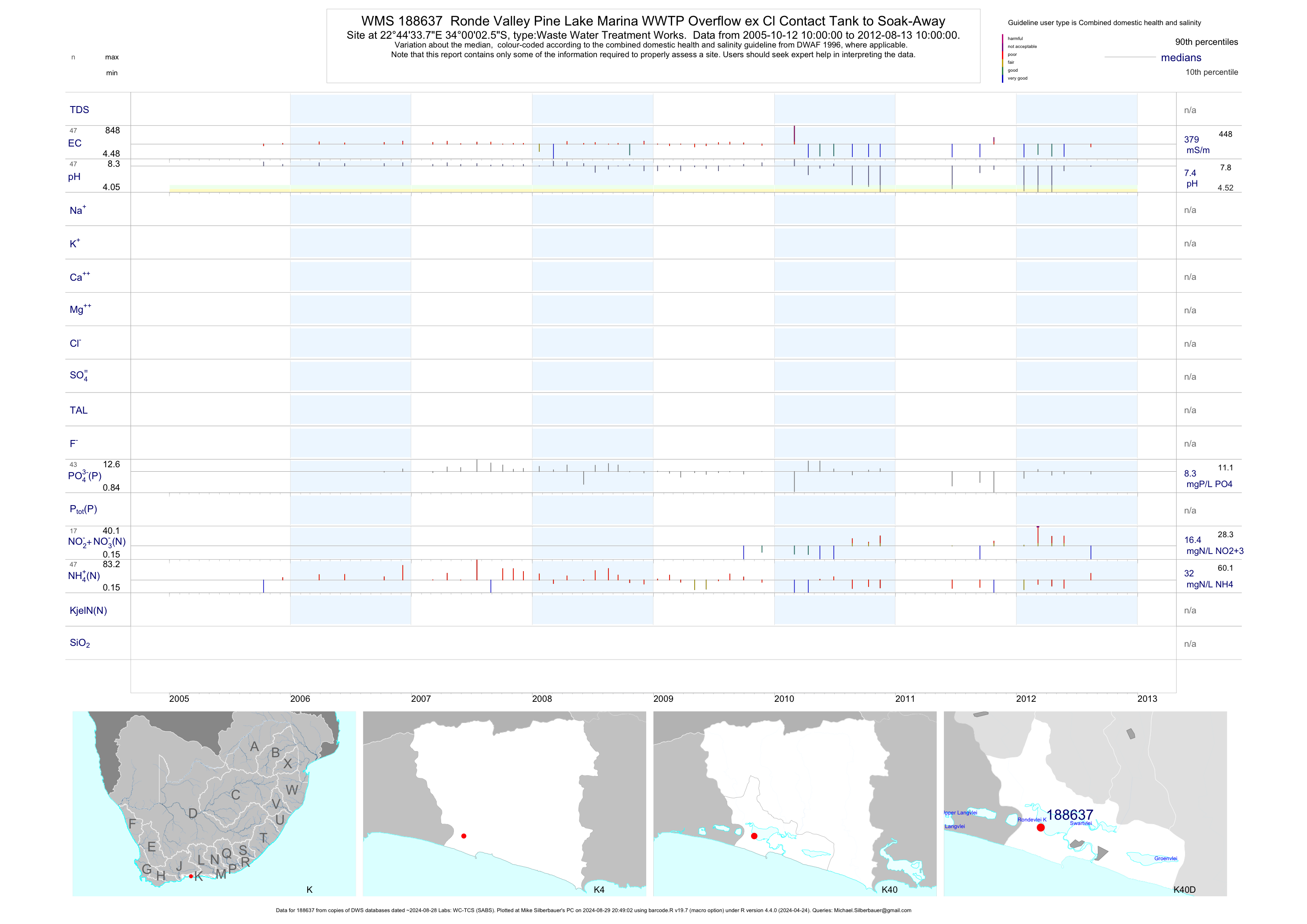
| K40 188637 | plot | data | Ronde Valley Pine Lake Marina WWTP Overflow ex Cl Contact Tank to Soak-Away | Waste Water Treatment Works | 140 | 1993-08-16 | 2010-04-13 | 346 | 188637 | -34.00070 | 22.74270 |
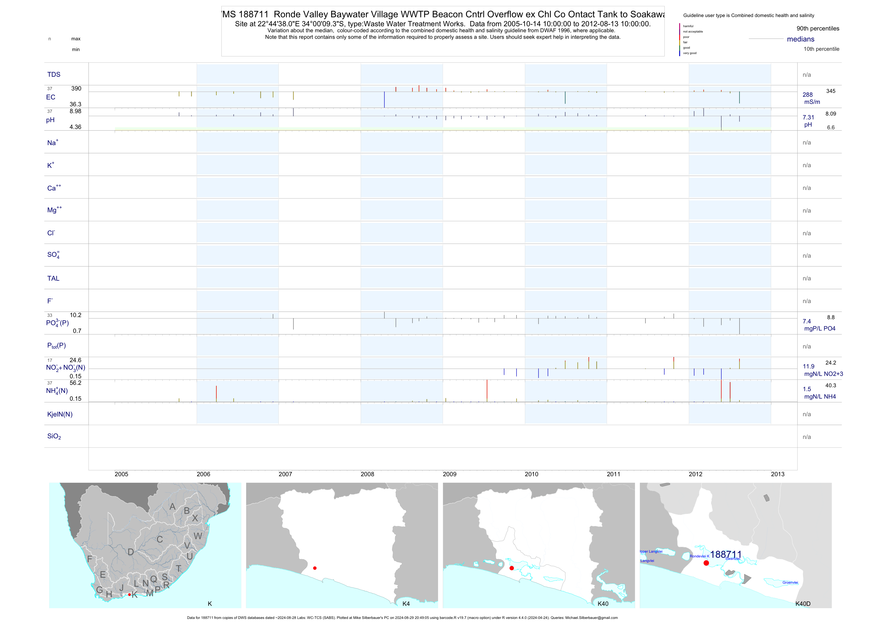
| K40 188711 | plot | data | Ronde Valley Baywater Village WWTP Beacon Cntrl Overflow ex Chl Co Ontact Tank to Soakaway | Waste Water Treatment Works | 24 | 2005-10-14 | 2010-04-13 | 288 | 188711 | -34.00260 | 22.74390 |
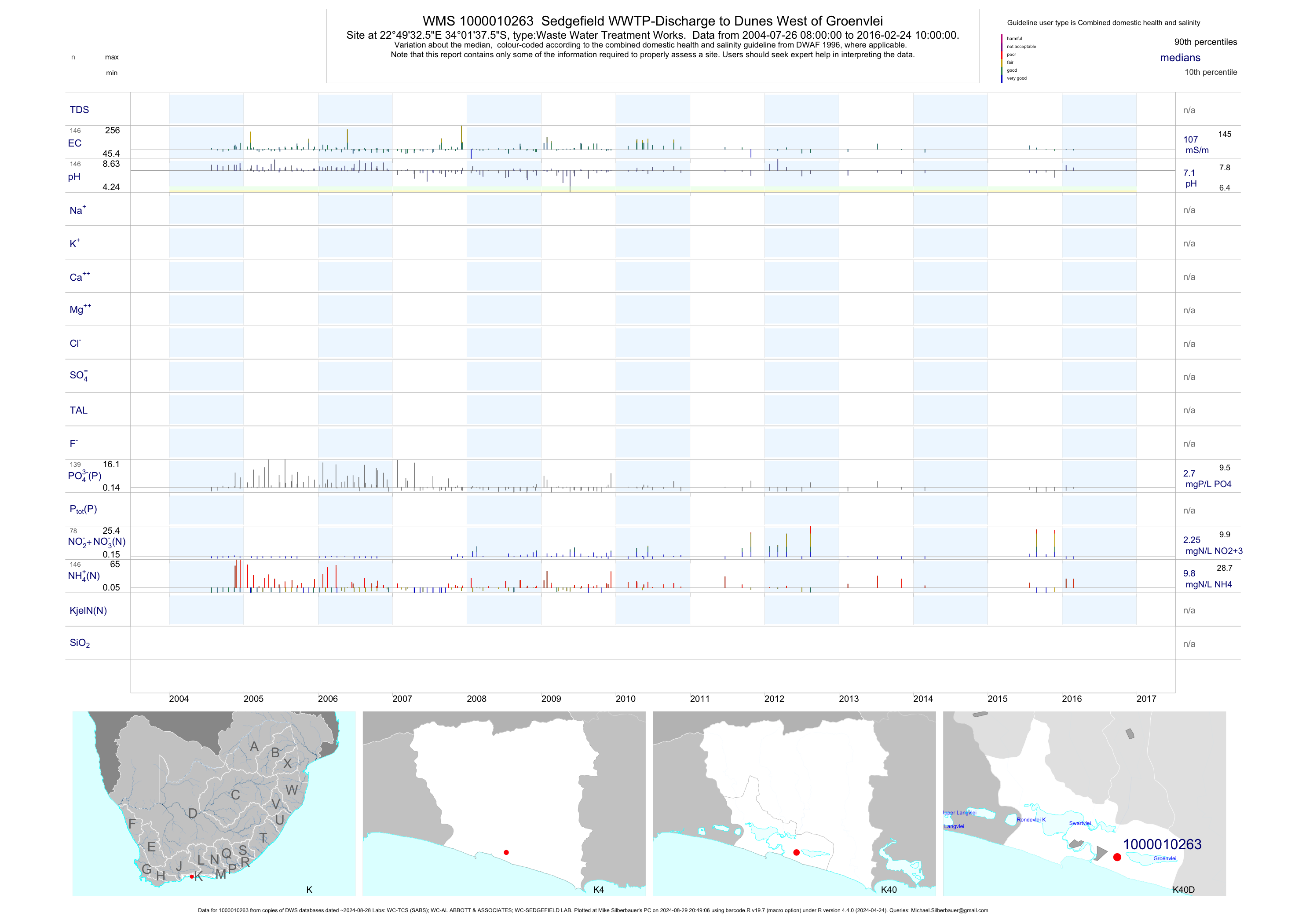
| K40 1000010263 | plot | data | Sedgefield WWTP-Discharge to Dunes West of Groenvlei | Waste Water Treatment Works | 323 | 1997-11-05 | 2016-02-24 | 107 | 1-10263 | -34.02710 | 22.82570 |
| K40 1000010290 | plot | data | Rheenendal Beacon WWTP-Discharge to Homtini River | Waste Water Treatment Works | 189 | 1995-11-20 | 2009-11-24 | 118 | 1-10290 | -33.94990 | 22.92630 |
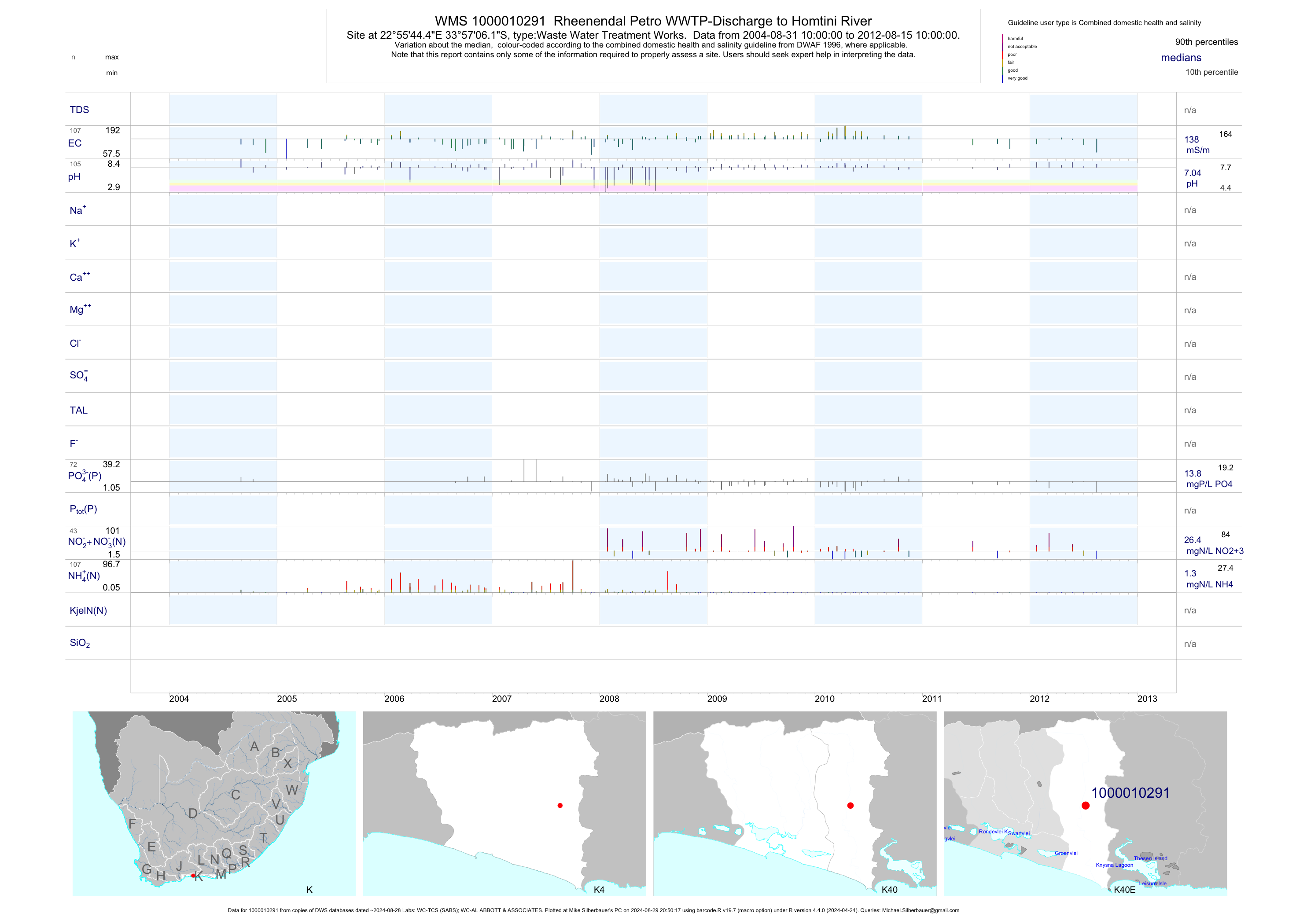
| K40 1000010291 | plot | data | Rheenendal Petro WWTP-Discharge to Homtini River | Waste Water Treatment Works | 191 | 2002-03-19 | 2012-08-15 | 137 | 1-10291 | -33.95170 | 22.92900 |
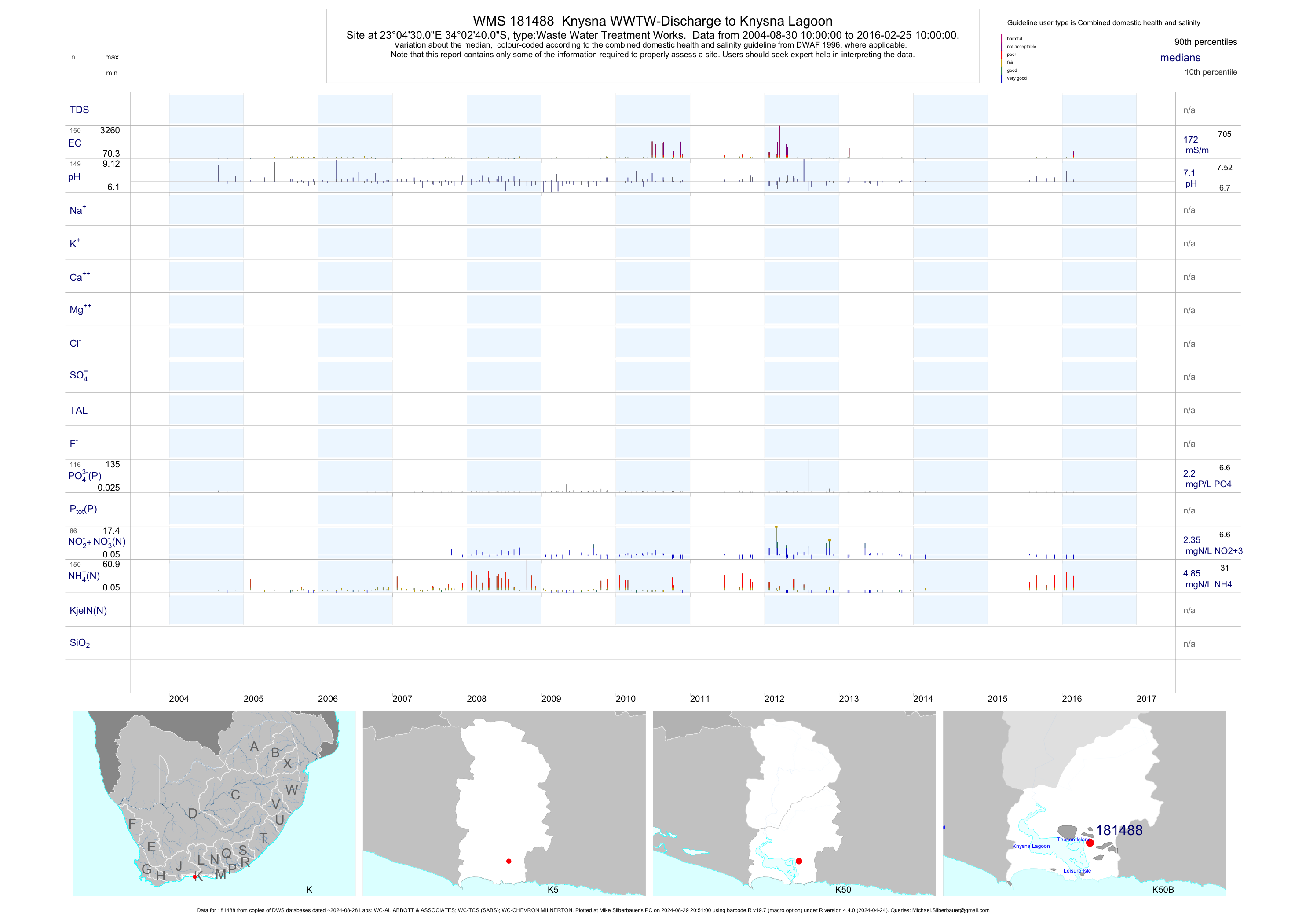
| K50 181488 | plot | data | Knysna WWTW-Discharge to Knysna Lagoon | Waste Water Treatment Works | 544 | 1990-03-27 | 2016-02-25 | 212 | 181488 | -34.04444 | 23.07500 |
| K50 188611 | plot | data | Uitzigt Belvidere WWTP-Beacon Control-Overflow ex Chlorination Chamb Ber | Waste Water Treatment Works | 436 | 1991-12-19 | 2012-08-17 | 100 | 188611 | -34.04450 | 22.99480 |
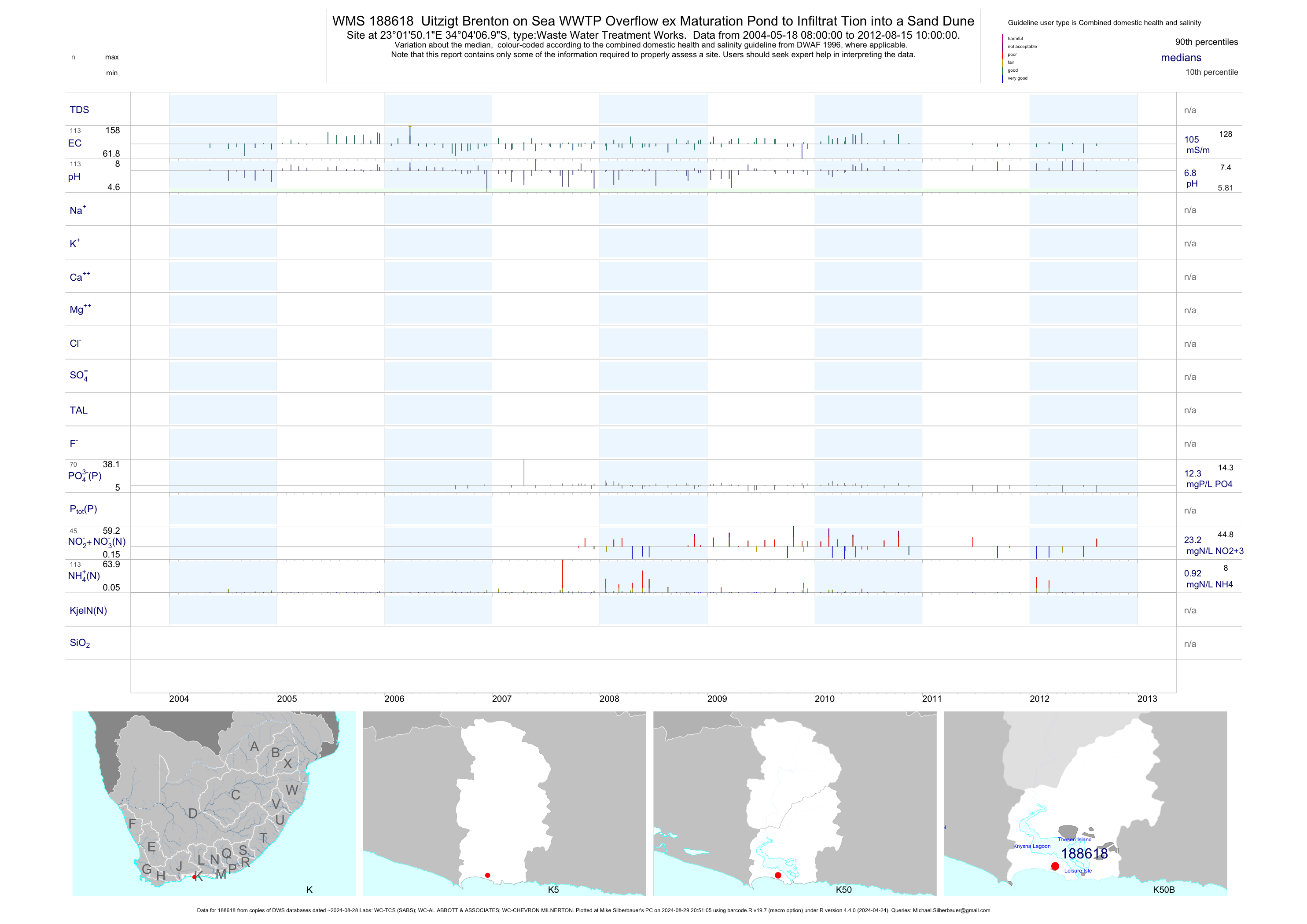
| K50 188618 | plot | data | Uitzigt Brenton on Sea WWTP Overflow ex Maturation Pond to Infiltrat Tion into a Sand Dune | Waste Water Treatment Works | 169 | 2004-05-18 | 2012-08-15 | 105 | 188618 | -34.06860 | 23.03060 |
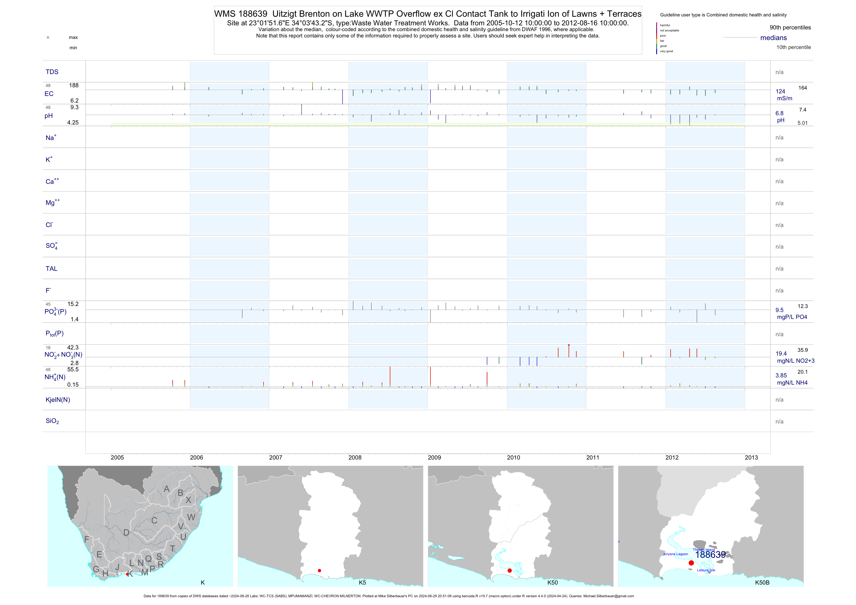
| K50 188639 | plot | data | Uitzigt Brenton on Lake WWTP Overflow ex Cl Contact Tank to Irrigati Ion of Lawns + Terraces | Waste Water Treatment Works | 33 | 2005-10-12 | 2010-03-01 | 124 | 188639 | -34.06200 | 23.03100 |
| K50 188641 | plot | data | Uitzigt Clearwater WWTP Overflow ex Cl Contact Tank to Large Maturat Tion Dam | Waste Water Treatment Works | 239 | 1998-01-06 | 2010-03-05 | 140 | 188641 | -34.03510 | 22.99260 |
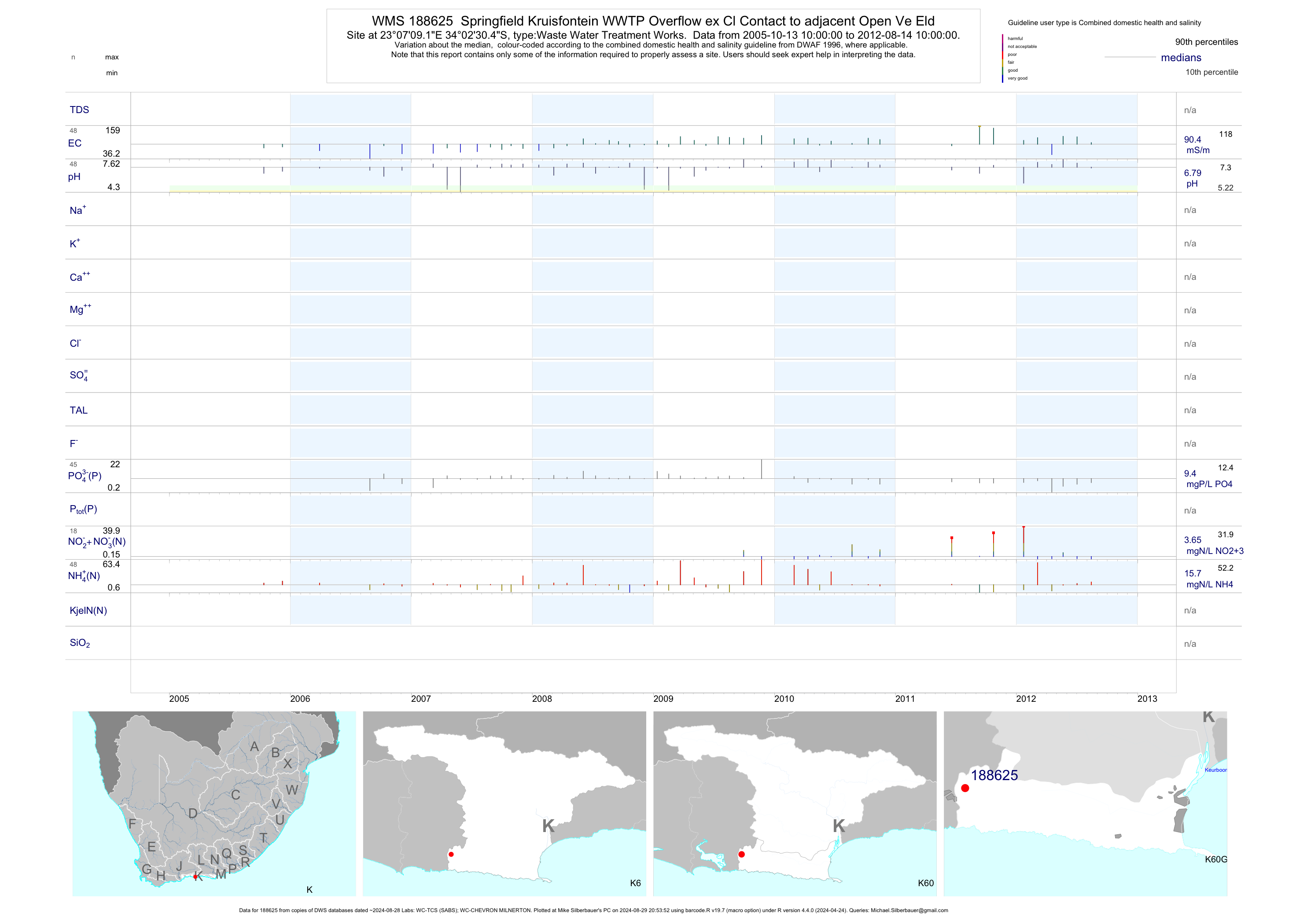
| K60 188625 | plot | data | Springfield Kruisfontein WWTP Overflow ex Cl Contact to adjacent Open Ve Eld | Waste Water Treatment Works | 33 | 2005-10-13 | 2010-03-01 | 90 | 188625 | -34.04180 | 23.11920 |
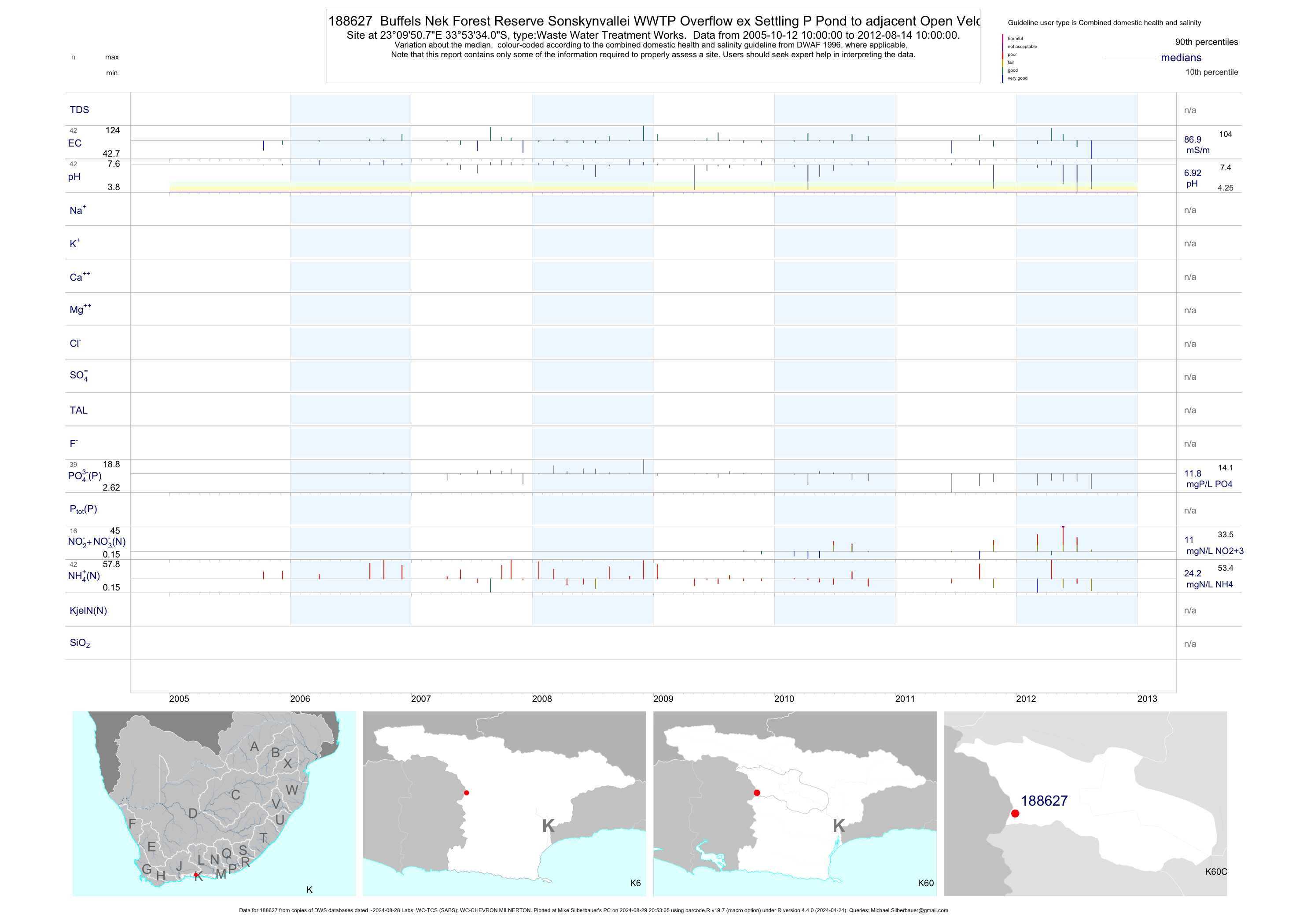
| K60 188627 | plot | data | Buffels Nek Forest Reserve Sonskynvallei WWTP Overflow ex Settling P Pond to adjacent Open Veld Area | Waste Water Treatment Works | 29 | 2005-10-12 | 2010-03-01 | 87 | 188627 | -33.89280 | 23.16410 |
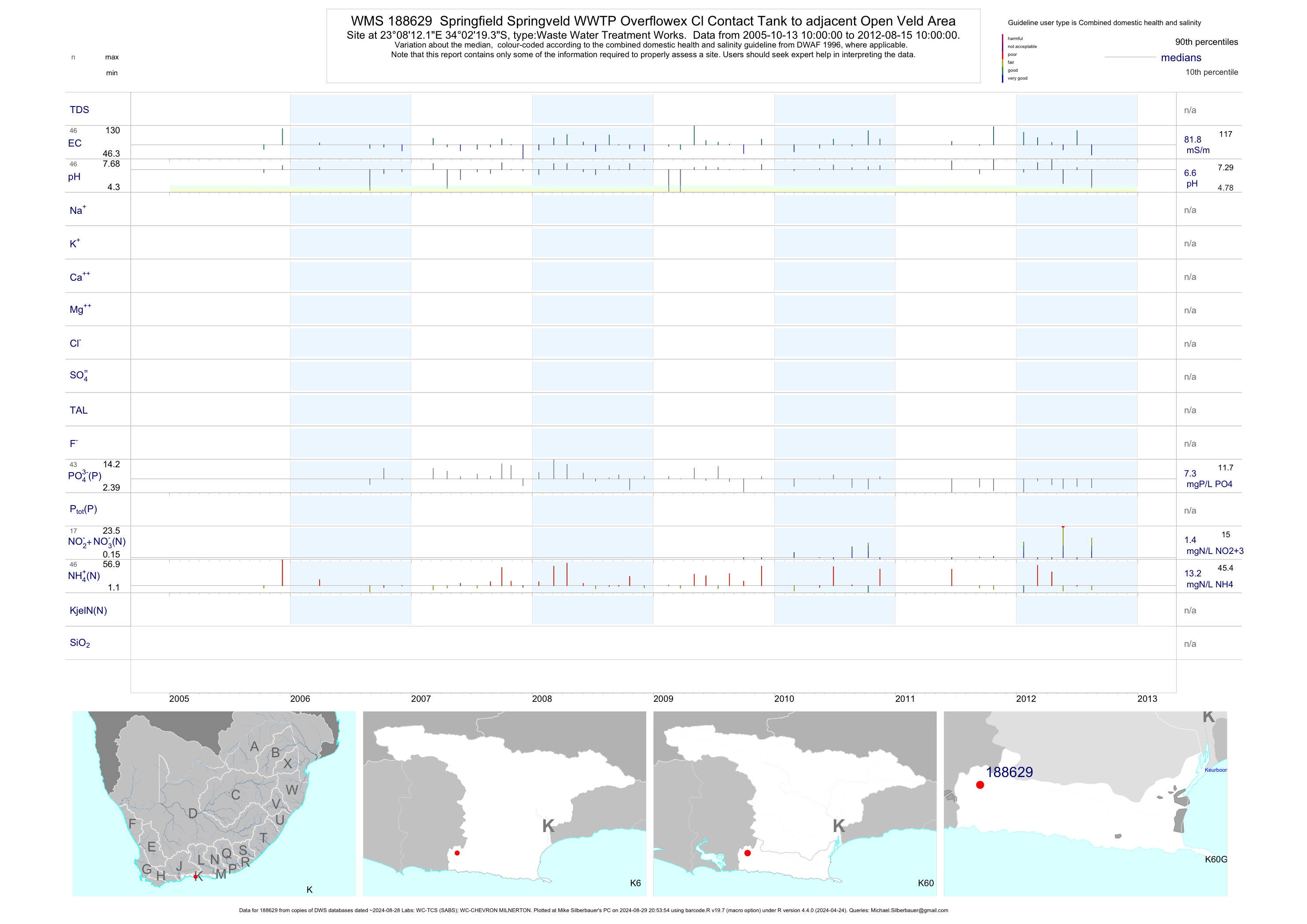
| K60 188629 | plot | data | Springfield Springveld WWTP Overflowex Cl Contact Tank to adjacent Open Veld Area | Waste Water Treatment Works | 32 | 2005-10-13 | 2010-03-01 | 82 | 188629 | -34.03870 | 23.13670 |
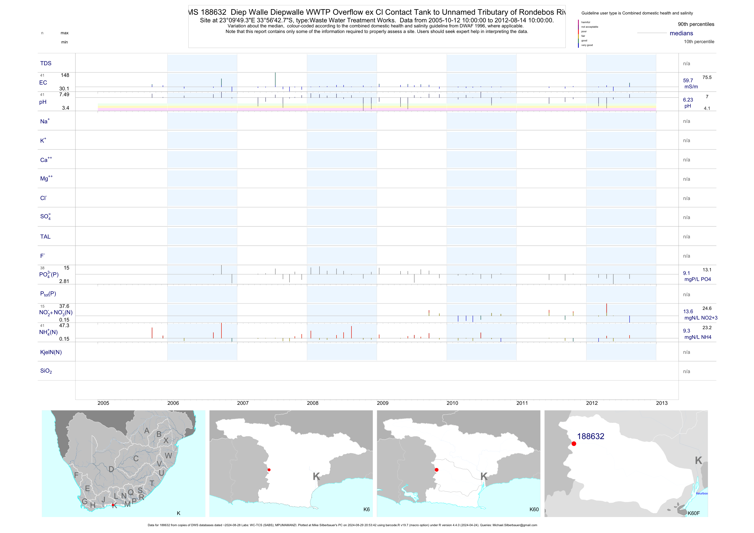
| K60 188632 | plot | data | Diep Walle Diepwalle WWTP Overflow ex Cl Contact Tank to Unnamed Tributary of Rondebos River | Waste Water Treatment Works | 29 | 2005-10-12 | 2010-03-01 | 60 | 188632 | -33.94520 | 23.16370 |
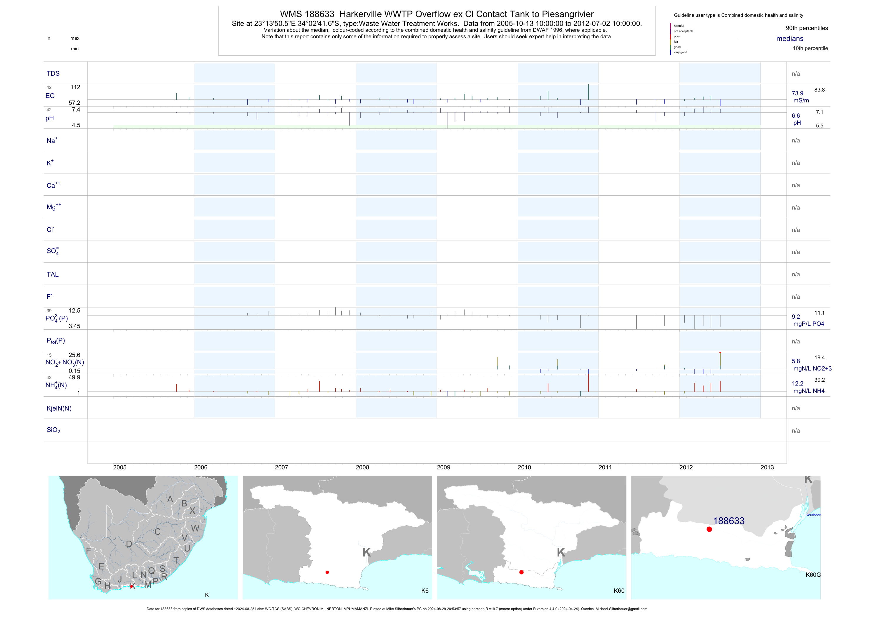
| K60 188633 | plot | data | Harkerville WWTP Overflow ex Cl Contact Tank to Piesangrivier | Waste Water Treatment Works | 29 | 2005-10-13 | 2009-11-23 | 74 | 188633 | -34.04490 | 23.23070 |
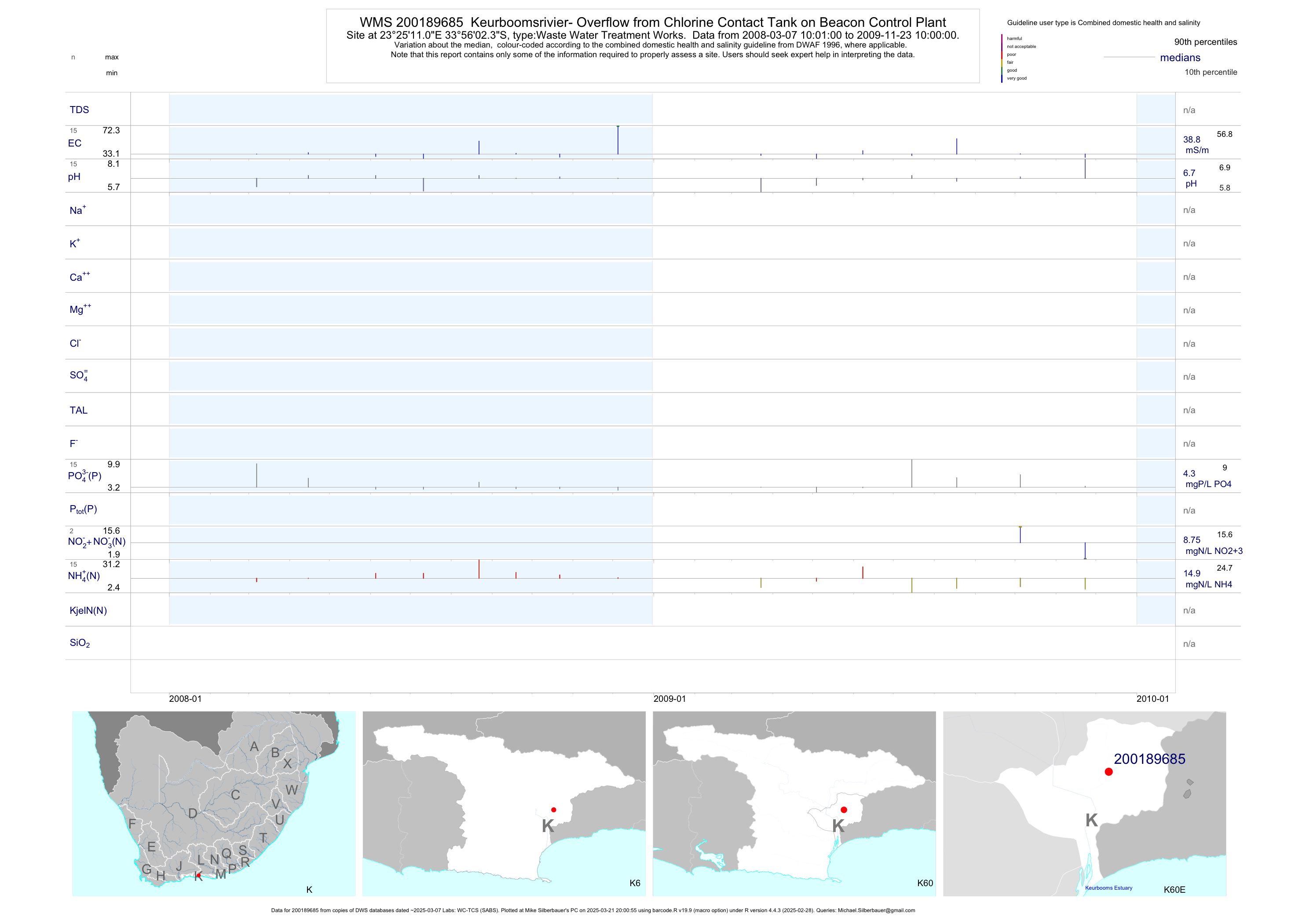
| K60 200189685 | plot | data | Keurboomsrivier- Overflow from Chlorine Contact Tank on Beacon Control Plant | Waste Water Treatment Works | 17 | 2008-03-07 | 2009-11-23 | 39 | 200189685 | -33.93399 | 23.41974 |
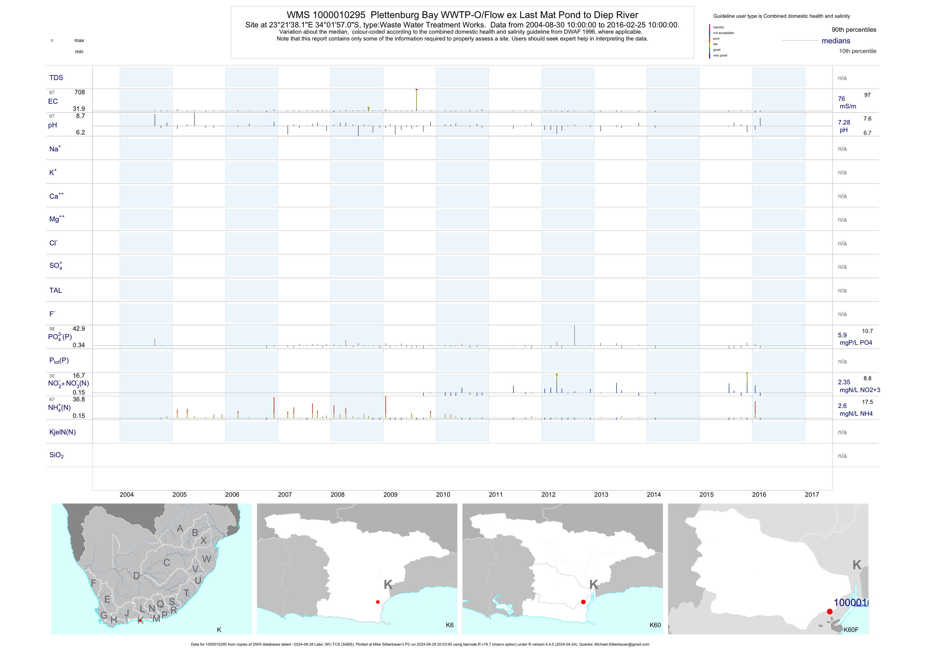
| K60 1000010295 | plot | data | Plettenburg Bay WWTP-O/Flow ex Last Mat Pond to Diep River | Waste Water Treatment Works | 68 | 2004-08-30 | 2016-02-25 | 76 | 1-10295 | -34.03250 | 23.36060 |
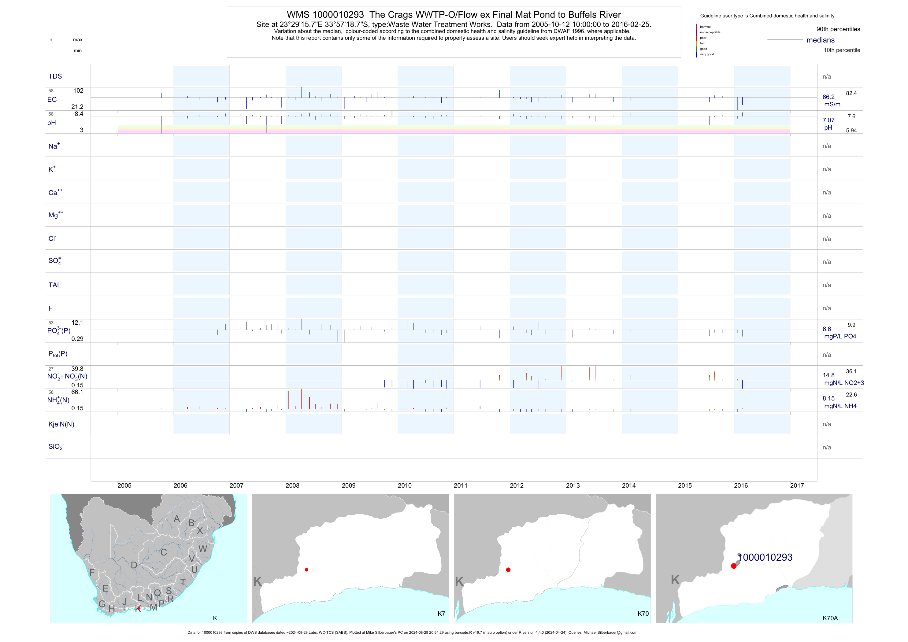
| K70 1000010293 | plot | data | The Crags WWTP-O/Flow ex Final Mat Pond to Buffels River | Waste Water Treatment Works | 57 | 2005-10-12 | 2016-01-21 | 66 | 1-10293 | -33.95520 | 23.48770 |
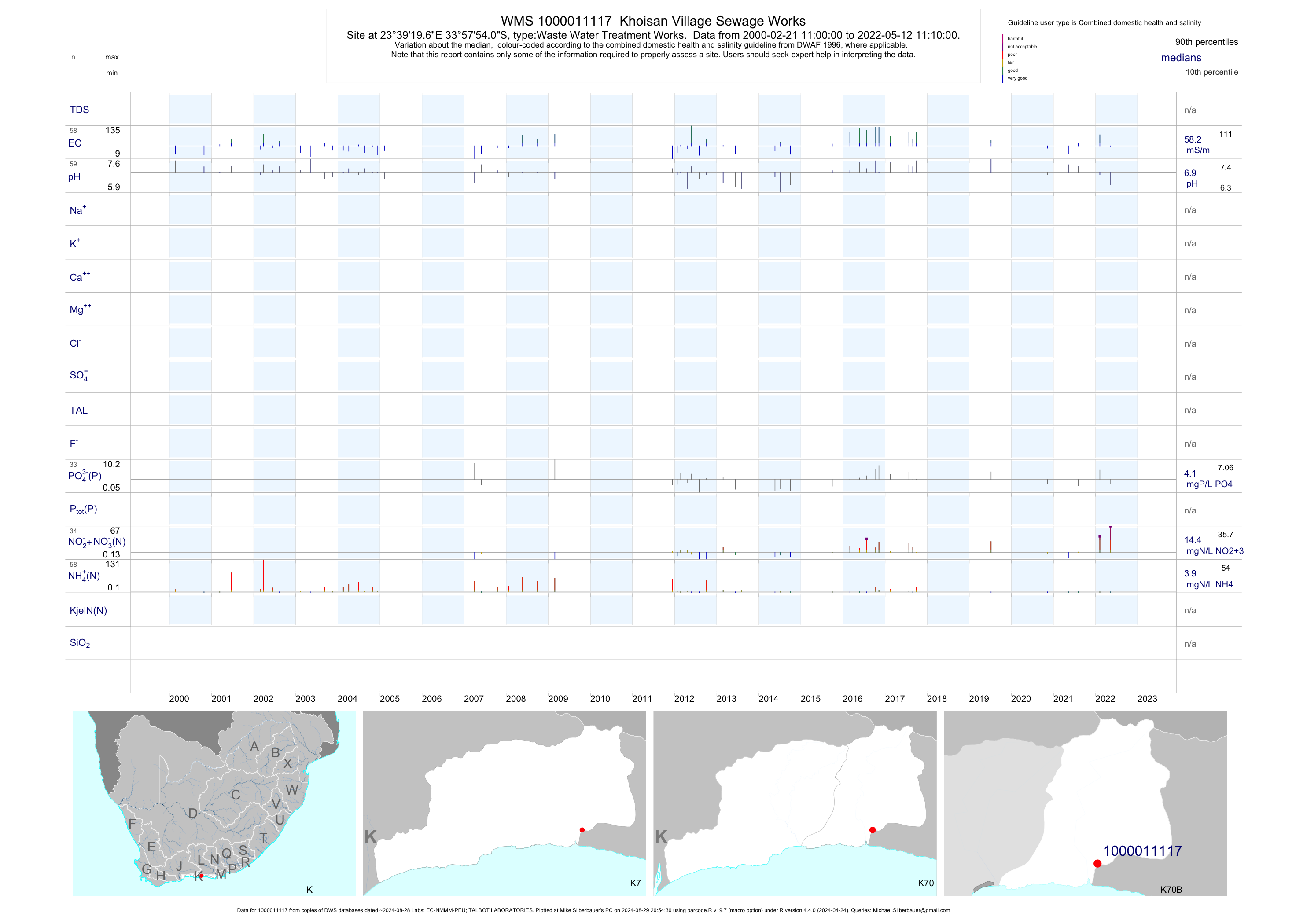
| K70 1000011117 | plot | data | Khoisan Village Sewage Works | Waste Water Treatment Works | 92 | 2000-02-21 | 2019-07-09 | 60 | 1-11117 | -33.96503 | 23.65547 |
| K70 1000011302 | plot | data | Coldstream Sewage Works | Waste Water Treatment Works | 79 | 1999-10-26 | 2017-03-14 | 66 | 1-11302 | -33.95608 | 23.69375 |
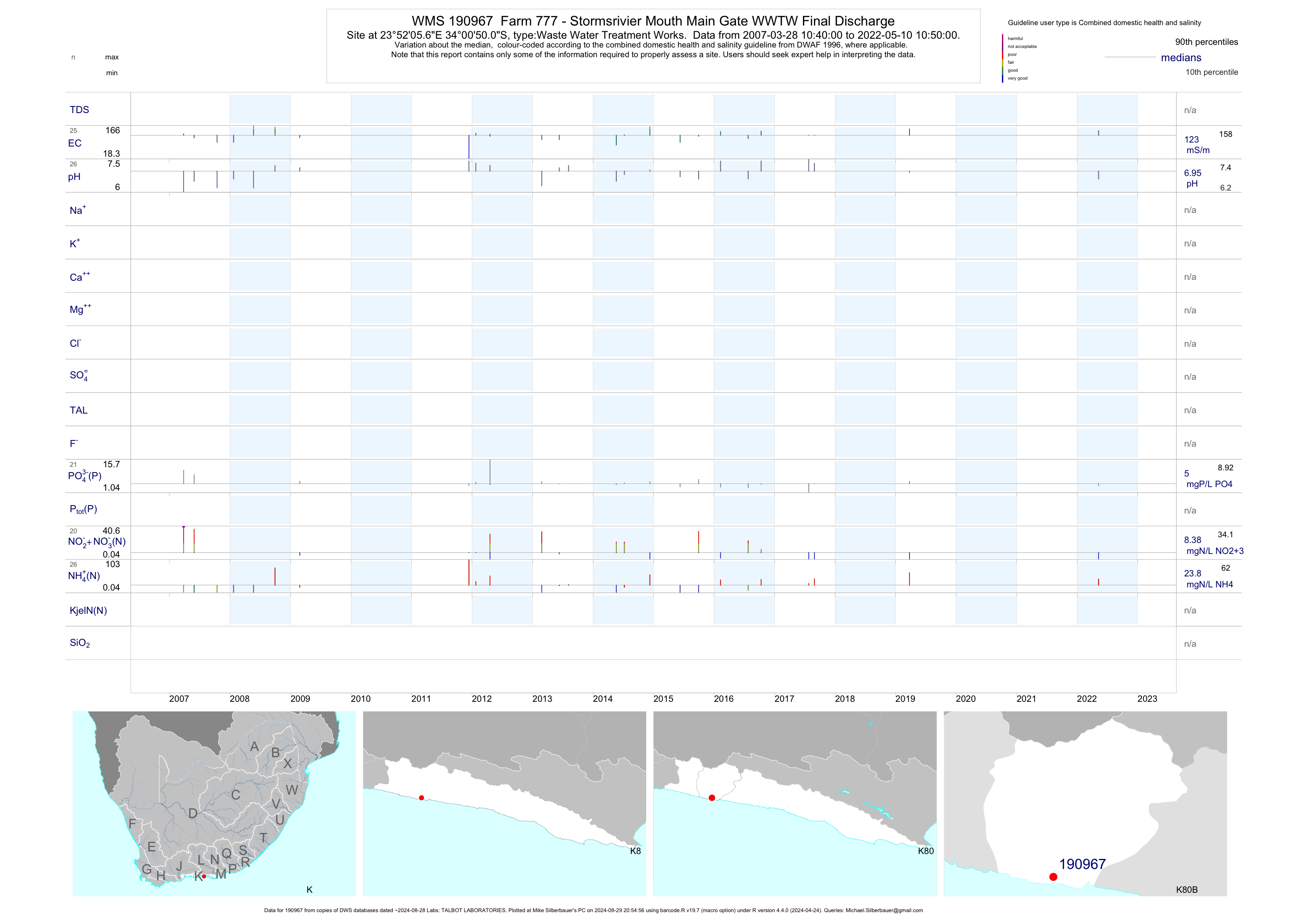
| K80 190967 | plot | data | Farm 777 - Stormsrivier Mouth Main Gate WWTW Final Discharge | Waste Water Treatment Works | 48 | 2007-03-28 | 2019-03-26 | 119 | 190967 | -34.01392 | 23.86825 |
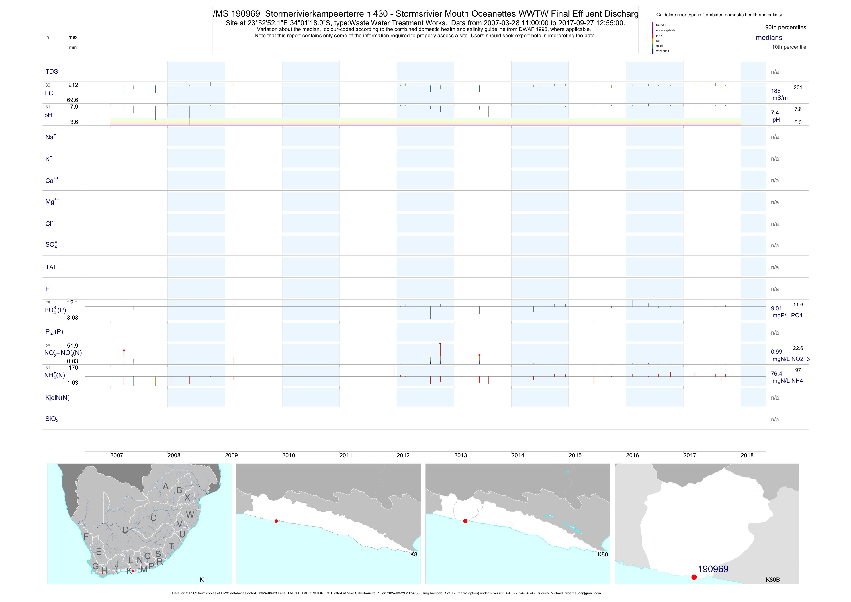
| K80 190969 | plot | data | Stormerivierkampeerterrein 430 - Stormsrivier Mouth Oceanettes WWTW Final Effluent Discharge | Waste Water Treatment Works | 63 | 2007-03-28 | 2017-09-27 | 186 | 190969 | -34.02167 | 23.88114 |
| K80 190971 | plot | data | Stormerivierkampeerterrein 430 - Stormsrivier Mouth Pool WWTW Final Effluent Discharge | Waste Water Treatment Works | 62 | 2007-03-28 | 2017-09-27 | 148 | 190971 | -34.02331 | 23.88800 |
| K80 190973 | plot | data | Farm 777 - Stormsrivier Mouth Restaurant WWTW Final Effluent Discharge | Waste Water Treatment Works | 54 | 2007-03-28 | 2019-03-26 | 157 | 190973 | -34.02061 | 23.89519 |
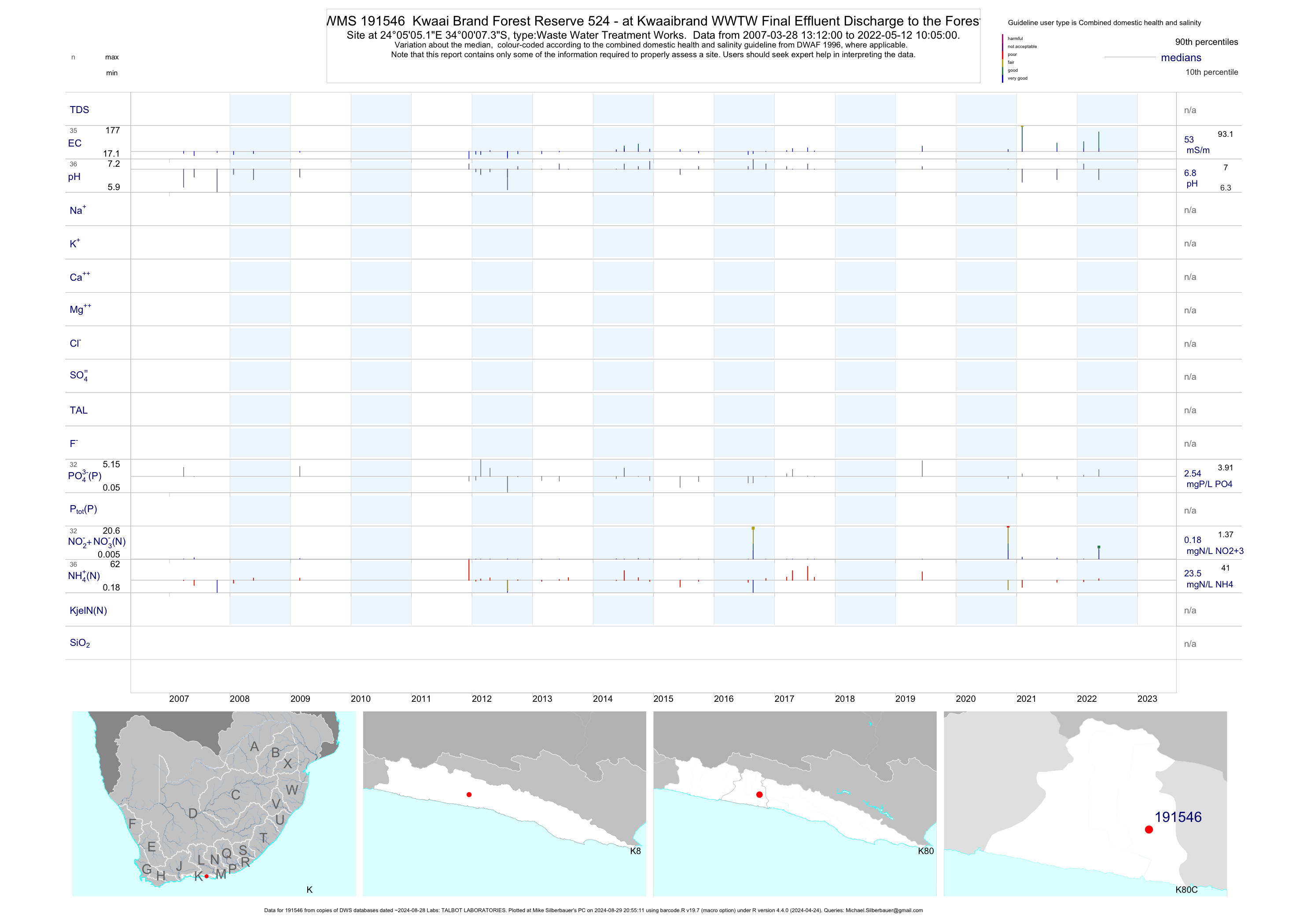
| K80 191546 | plot | data | Kwaai Brand Forest Reserve 524 - at Kwaaibrand WWTW Final Effluent Discharge to the Forest | Waste Water Treatment Works | 59 | 2007-03-28 | 2019-06-11 | 49 | 191546 | -34.00203 | 24.08477 |
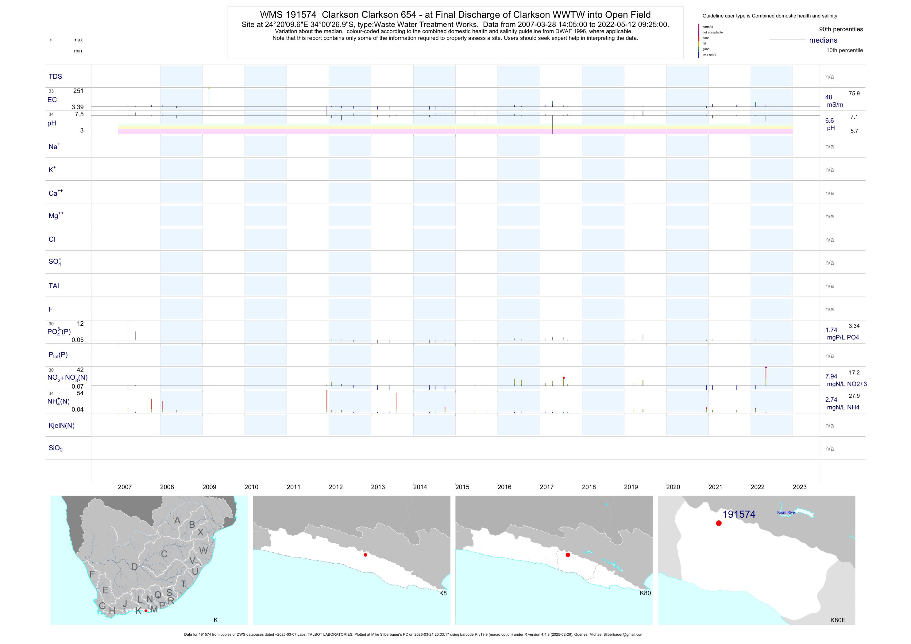
| K80 191574 | plot | data | Clarkson Clarkson 654 - at Final Discharge of Clarkson WWTW into Open Field | Waste Water Treatment Works | 56 | 2007-03-28 | 2019-06-12 | 46 | 191574 | -34.00750 | 24.33603 |
| K80 191575 | plot | data | Lottering State Forest - at Final Discharge of Lottering WWTW into Forest | Waste Water Treatment Works | 57 | 2007-03-28 | 2018-03-20 | 43 | 191575 | -33.96631 | 23.74497 |
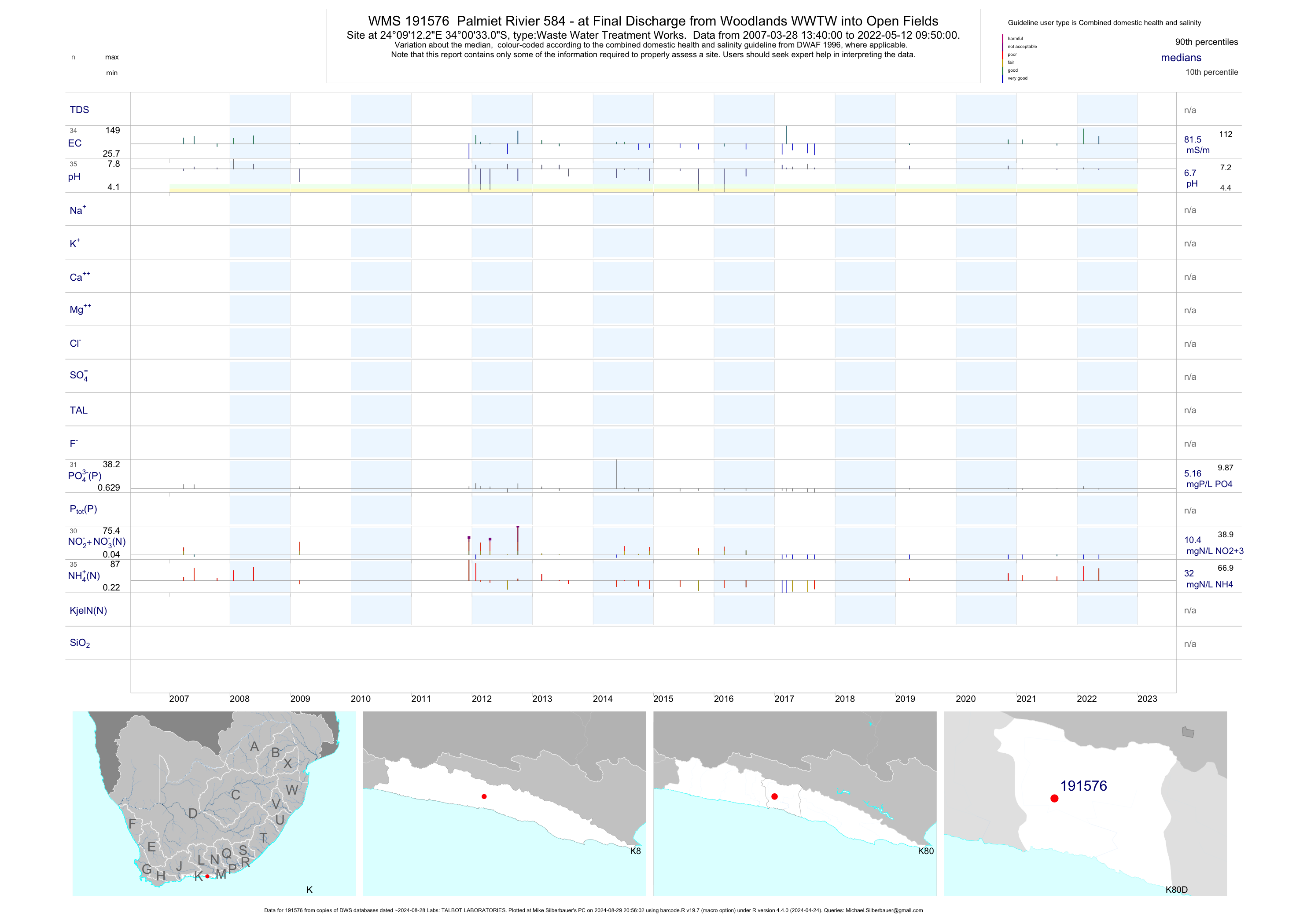
| K80 191576 | plot | data | Palmiet Rivier 584 - at Final Discharge from Woodlands WWTW into Open Fields | Waste Water Treatment Works | 58 | 2007-03-28 | 2019-03-26 | 80 | 191576 | -34.00919 | 24.15340 |
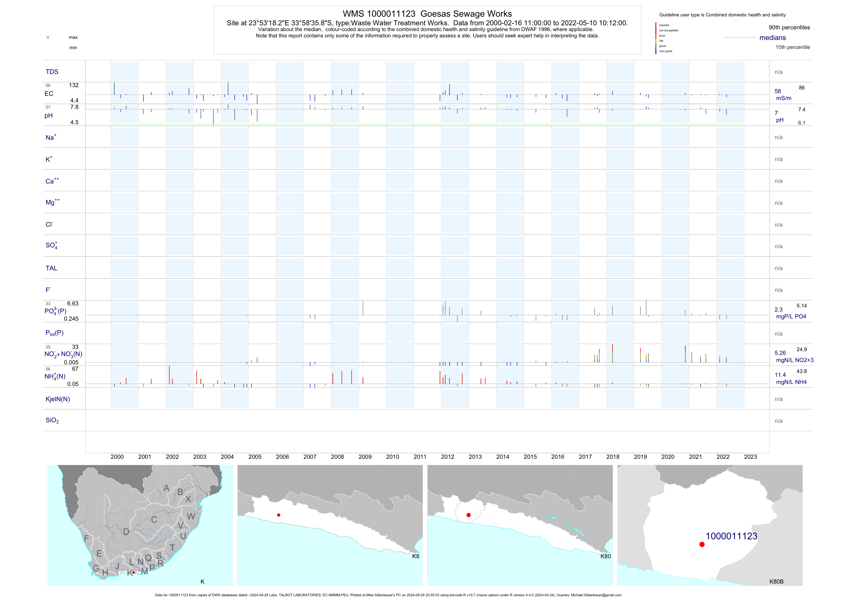
| K80 1000011123 | plot | data | Goesas Sewage Works | Waste Water Treatment Works | 94 | 2000-02-16 | 2019-07-10 | 56 | 1-11123 | -33.97661 | 23.88842 |
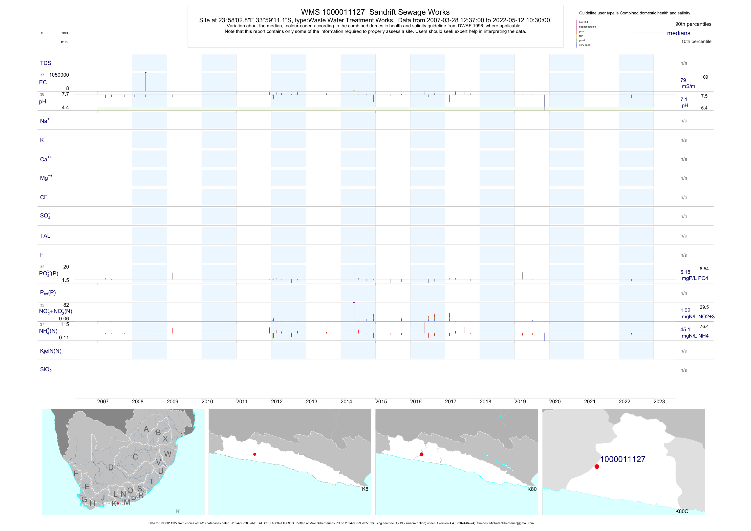
| K80 1000011127 | plot | data | Sandrift Sewage Works | Waste Water Treatment Works | 70 | 2007-03-28 | 2019-07-10 | 79 | 1-11127 | -33.98644 | 23.96744 |
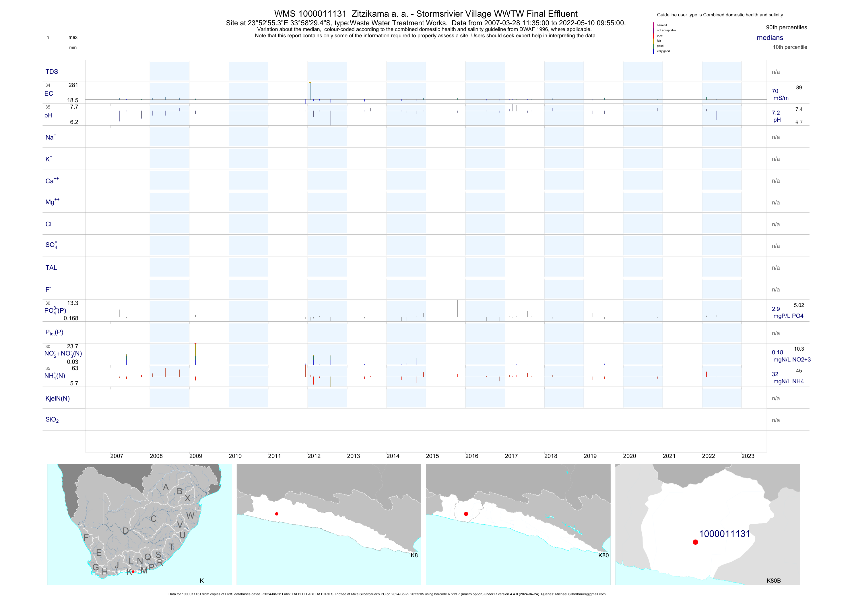
| K80 1000011131 | plot | data | Zitzikama a. a. - Stormsrivier Village WWTW Final Effluent | Waste Water Treatment Works | 61 | 2007-03-28 | 2019-07-10 | 68 | 1-11131 | -33.97483 | 23.88203 |
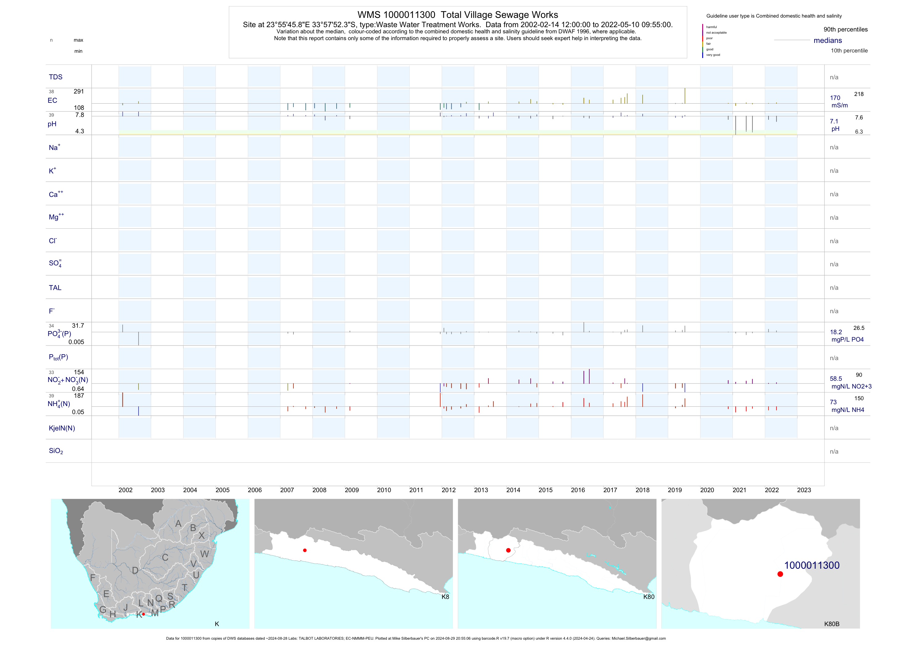
| K80 1000011300 | plot | data | Total Village Sewage Works | Waste Water Treatment Works | 66 | 2002-02-14 | 2019-07-10 | 168 | 1-11300 | -33.96456 | 23.92942 |
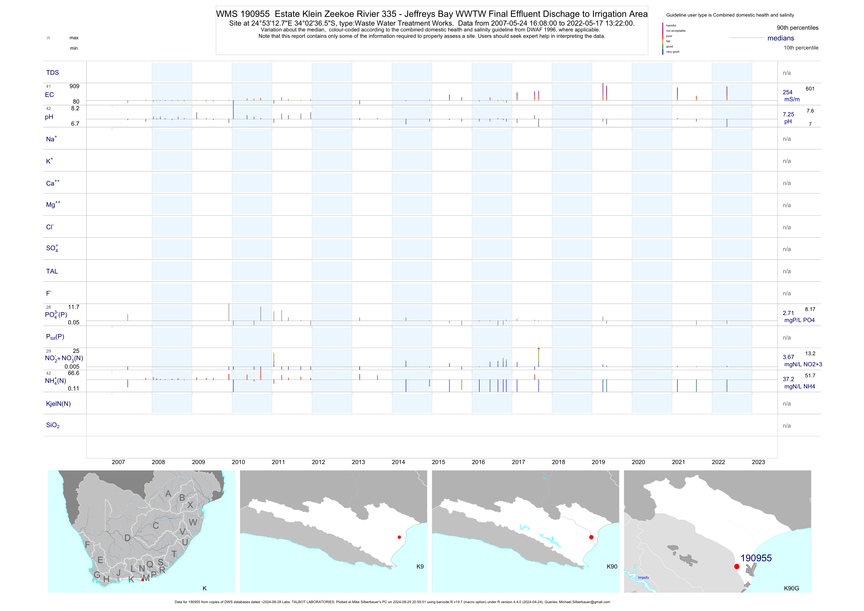
| K90 190955 | plot | data | Estate Klein Zeekoe Rivier 335 - Jeffreys Bay WWTW Final Effluent Dischage to Irrigation Area | Waste Water Treatment Works | 74 | 2007-05-24 | 2019-05-14 | 254 | 190955 | -34.04347 | 24.88686 |
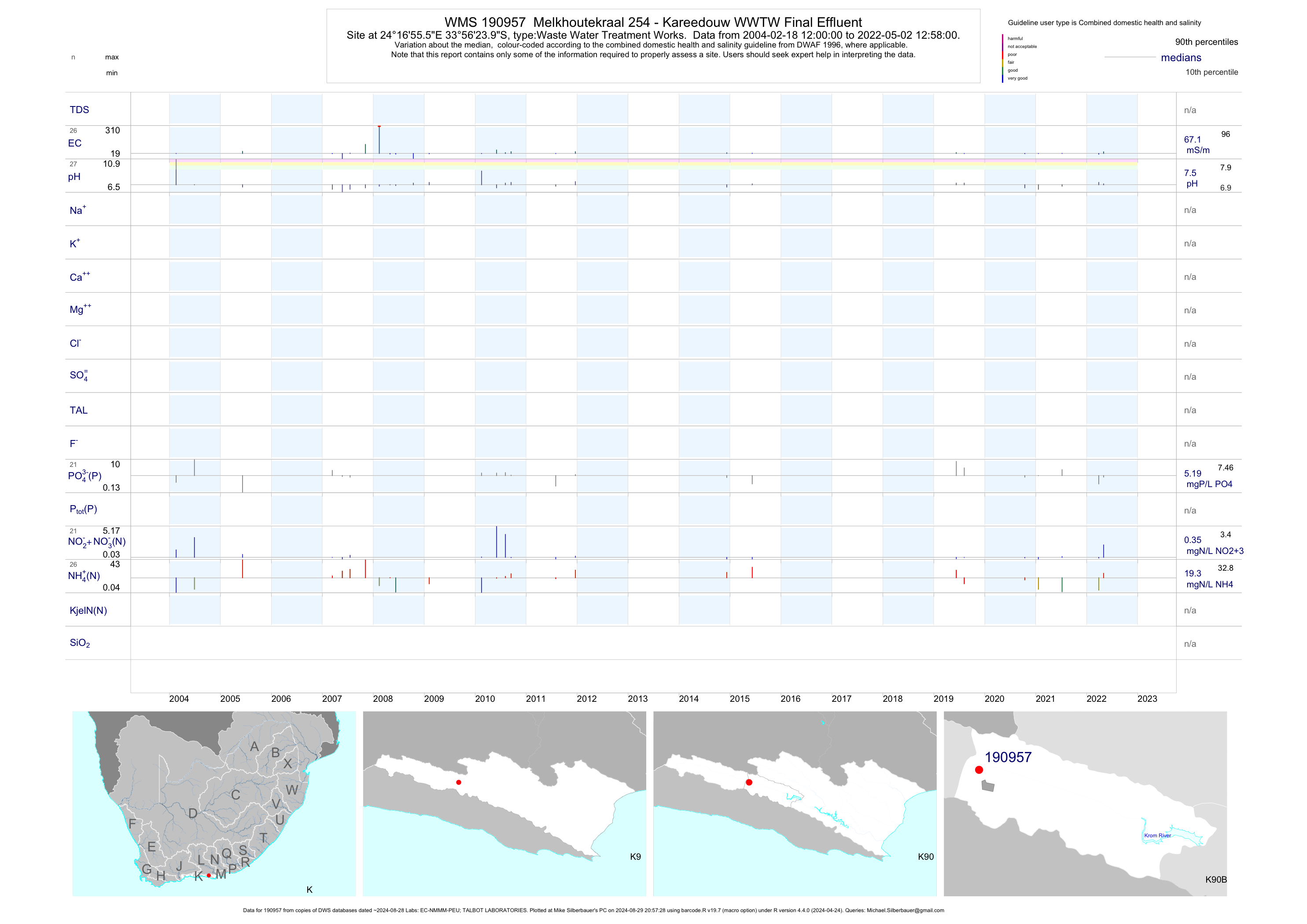
| K90 190957 | plot | data | Melkhoutekraal 254 - Kareedouw WWTW Final Effluent | Waste Water Treatment Works | 43 | 2004-02-18 | 2019-08-07 | 69 | 190957 | -33.94000 | 24.28211 |
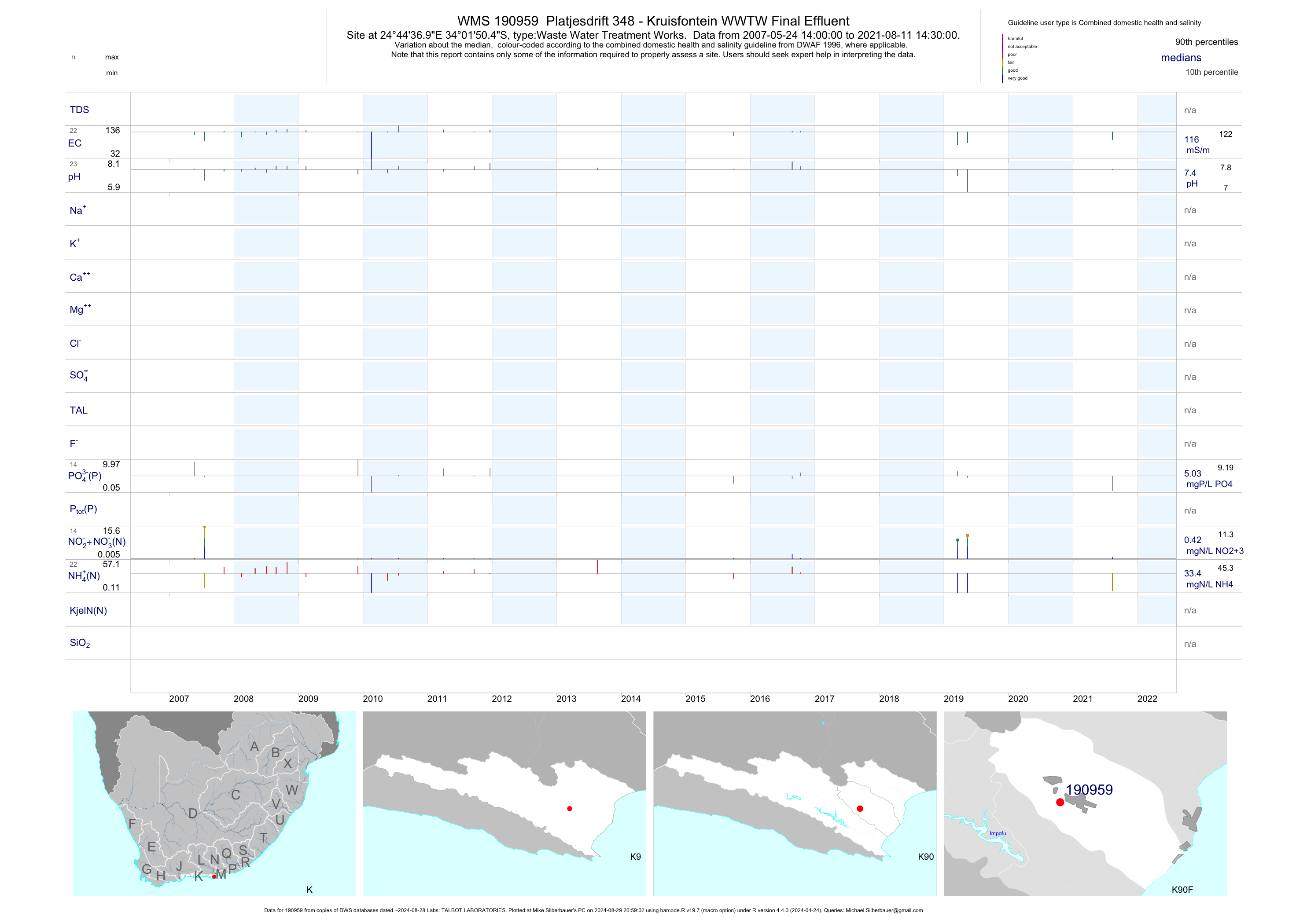
| K90 190959 | plot | data | Platjesdrift 348 - Kruisfontein WWTW Final Effluent | Waste Water Treatment Works | 45 | 2007-05-24 | 2019-05-14 | 116 | 190959 | -34.03069 | 24.74358 |
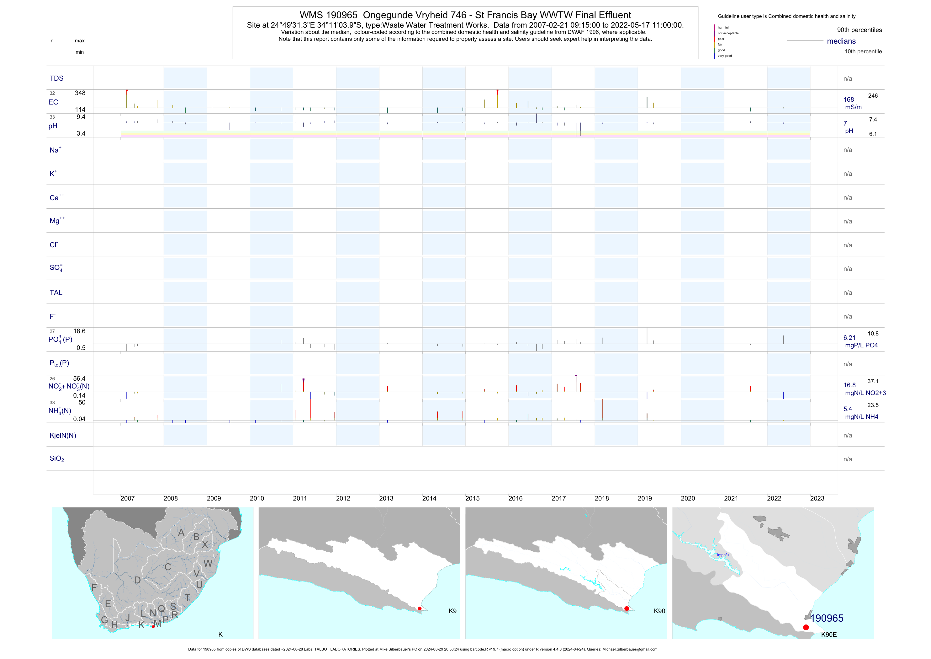
| K90 190965 | plot | data | Ongegunde Vryheid 746 - St Francis Bay WWTW Final Effluent | Waste Water Treatment Works | 57 | 2007-02-21 | 2019-05-14 | 168 | 190965 | -34.18444 | 24.82536 |
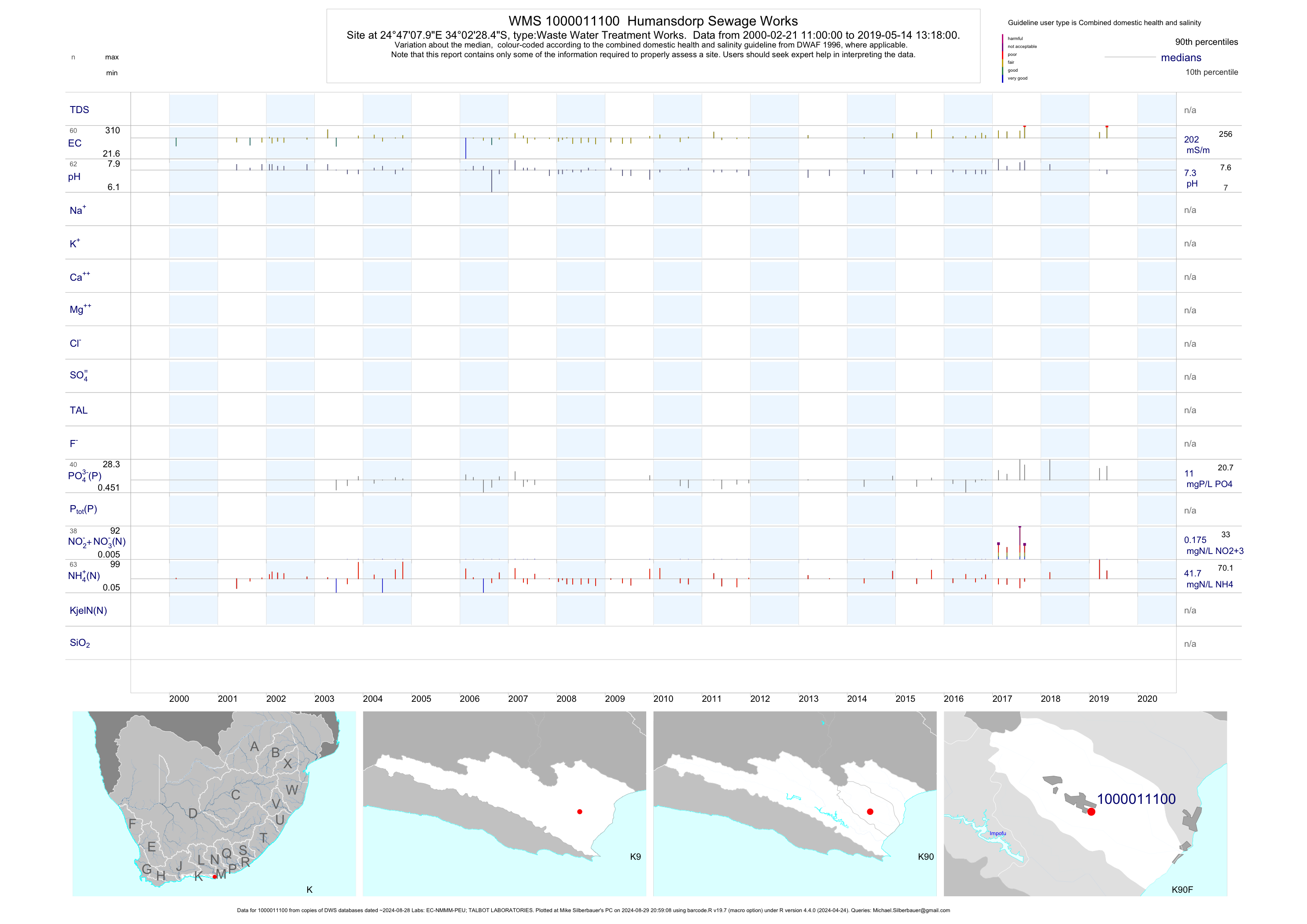
| K90 1000011100 | plot | data | Humansdorp Sewage Works | Waste Water Treatment Works | 121 | 2000-02-21 | 2019-05-14 | 197 | 1-11100 | -34.04125 | 24.78553 |
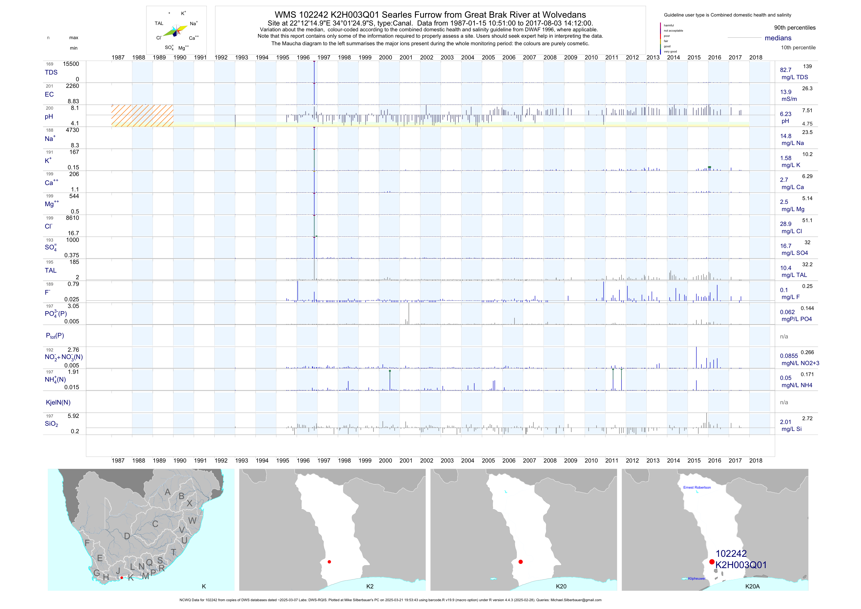
| K20 102242 | plot | data | Searles Furrow from Great Brak River at Wolvedans (NCWQ) | Canal | 202 | 1987-01-15 | 2017-08-03 | 14 | K2H003 | -34.02361 | 22.20417 |
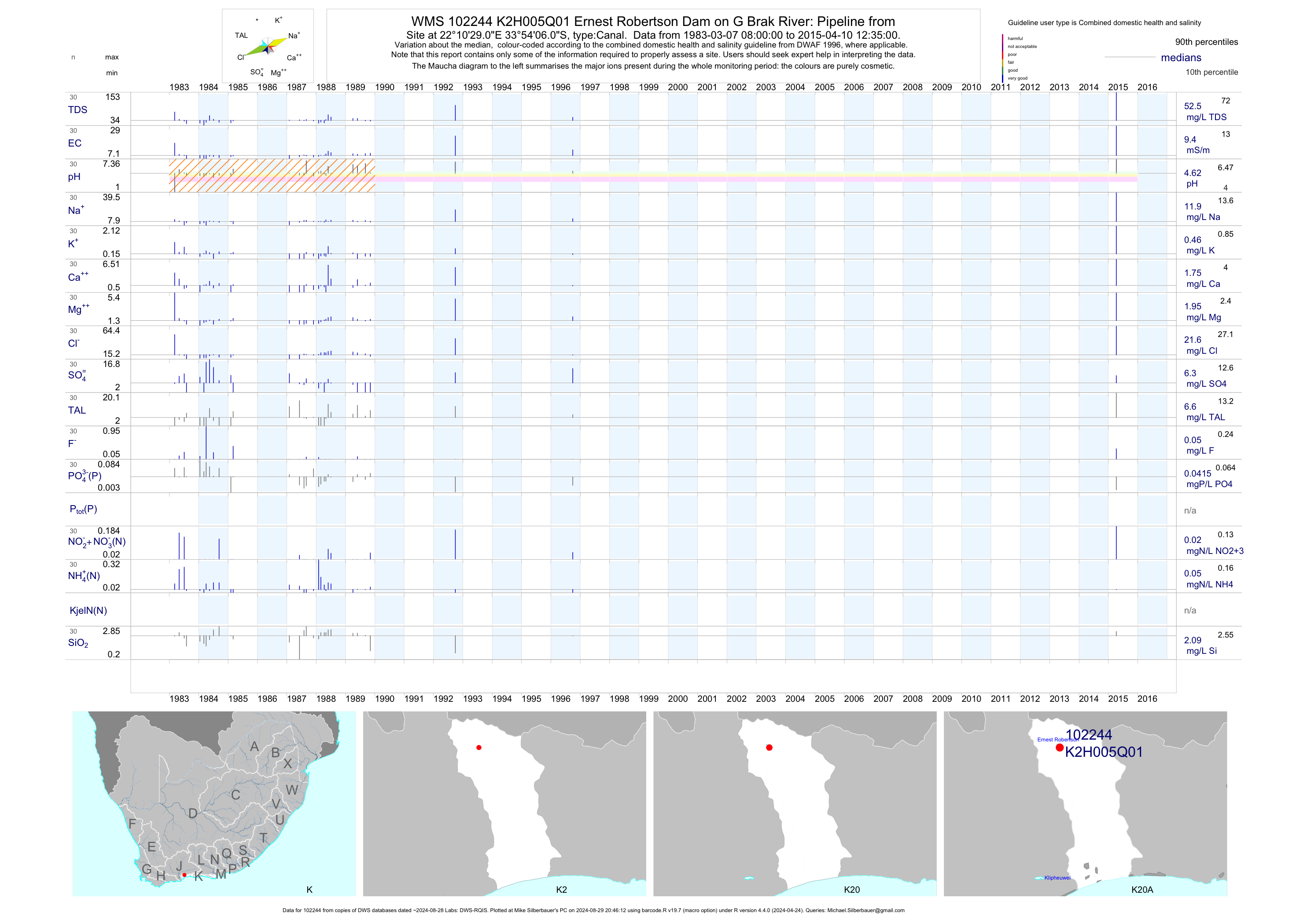
| K20 102244 | plot | data | Ernest Robertson Dam on G Brak River: Pipeline from | Canal | 30 | 1983-03-07 | 2015-04-10 | 9 | K2H005 | -33.90167 | 22.17472 |
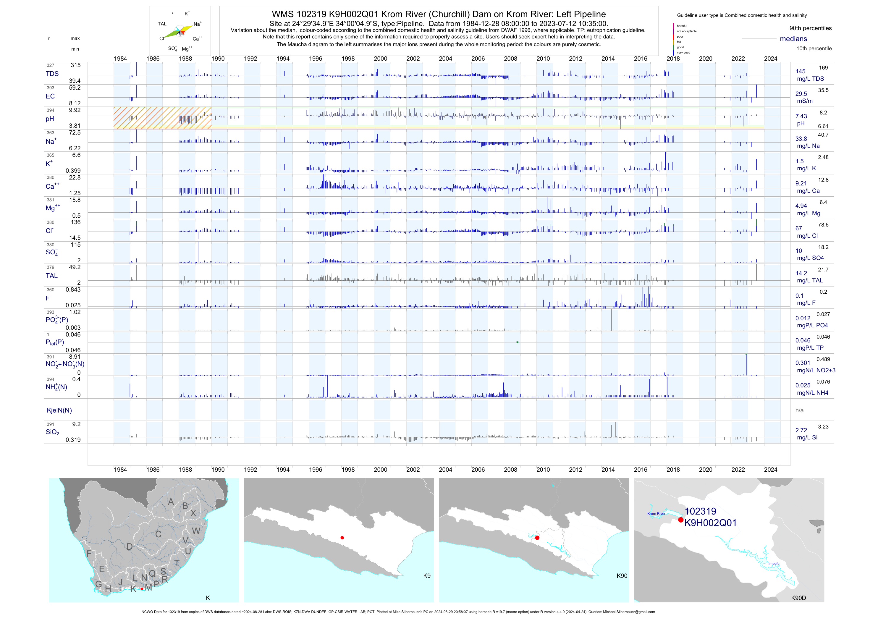
| K90 102319 | plot | data | Krom River (Churchill) Dam on Krom River: Left Pipeline (NCWQ) | Pipeline | 387 | 1984-12-28 | 2018-06-07 | 30 | K9H002 | -34.00139 | 24.49306 |
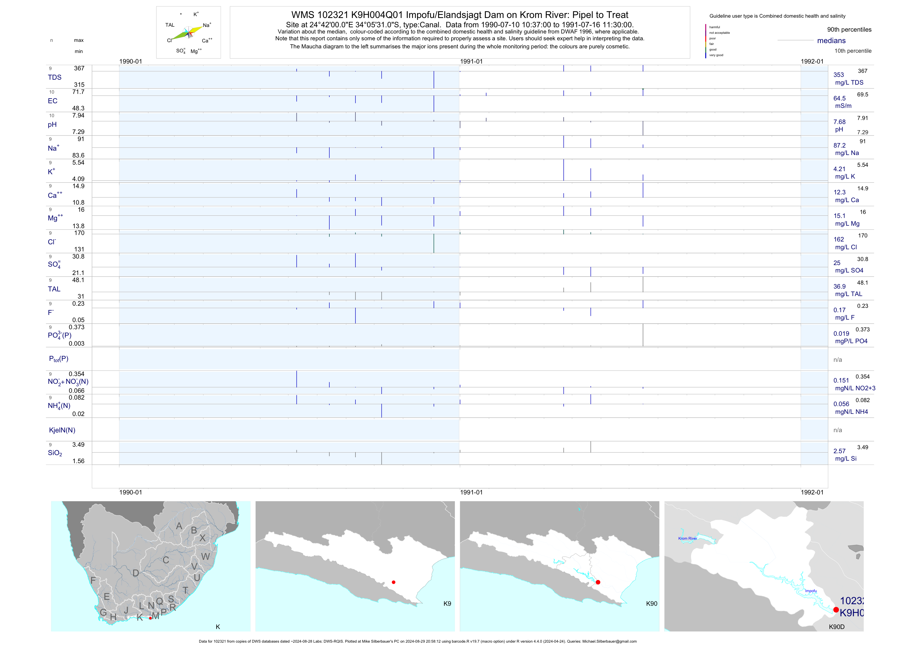
| K90 102321 | plot | data | Impofu/Elandsjagt Dam on Krom River: Pipel to Treat | Canal | 10 | 1990-07-10 | 1991-07-16 | 64 | K9H004 | -34.09194 | 24.70000 |
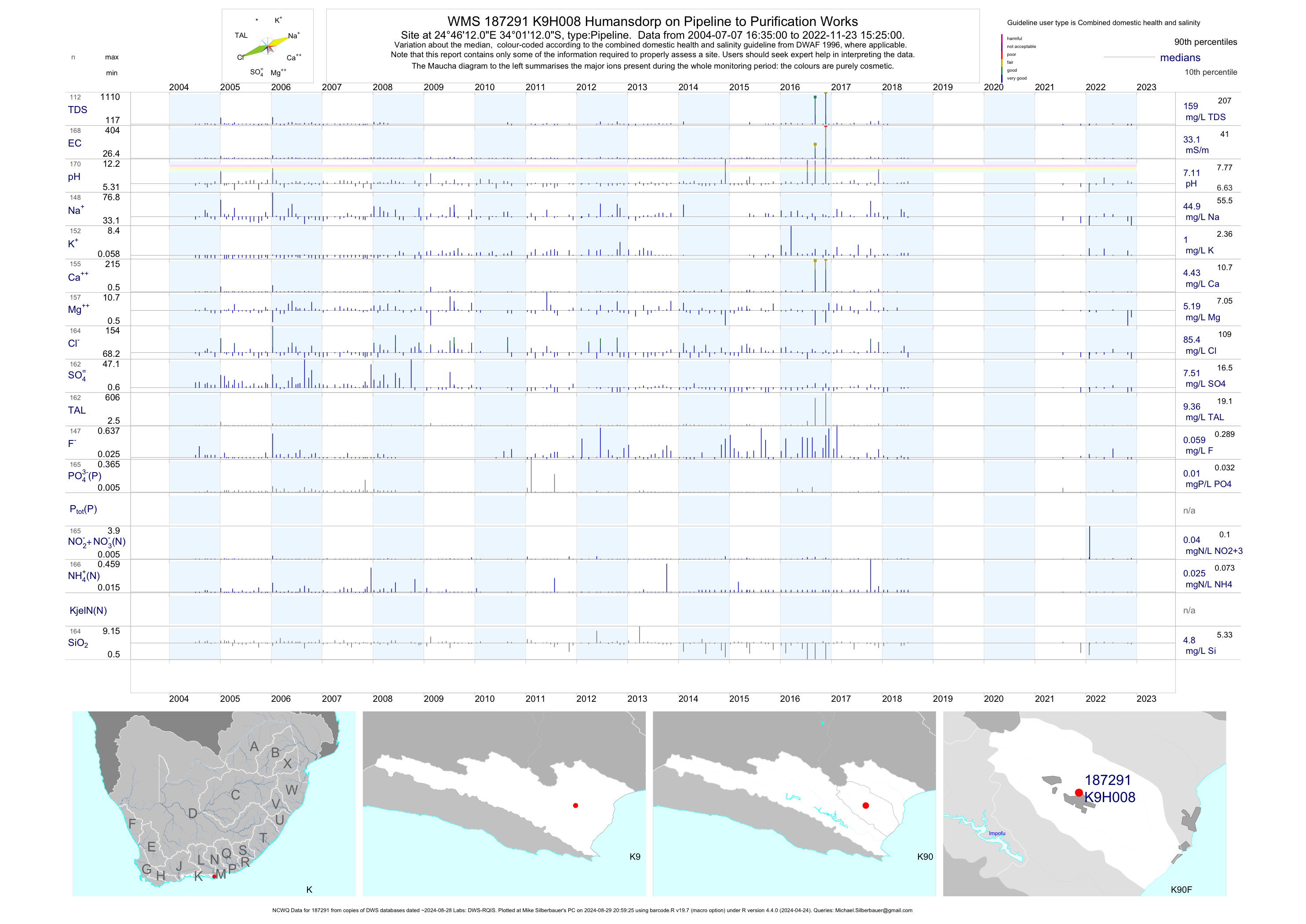
| K90 187291 | plot | data | Humansdorp on Pipeline to Purification Works (NCWQ) | Pipeline | 163 | 2004-07-07 | 2018-07-05 | 33 | K9H008 | -34.02000 | 24.77000 |
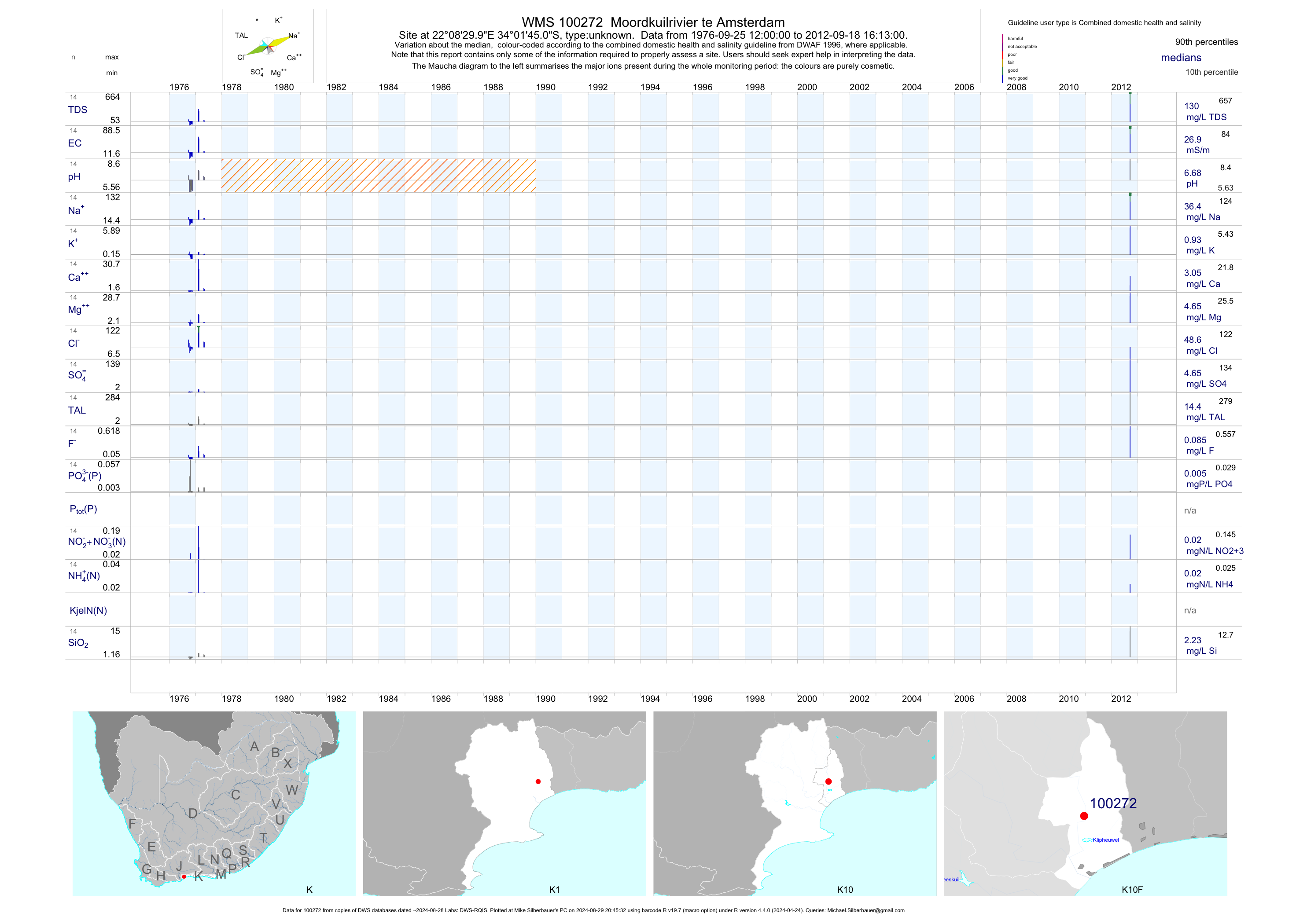
| K10 100272 | plot | data | Moordkuilrivier te Amsterdam | unknown | 14 | 1976-09-25 | 2012-09-18 | 27 | 100272 | -34.02917 | 22.14167 |
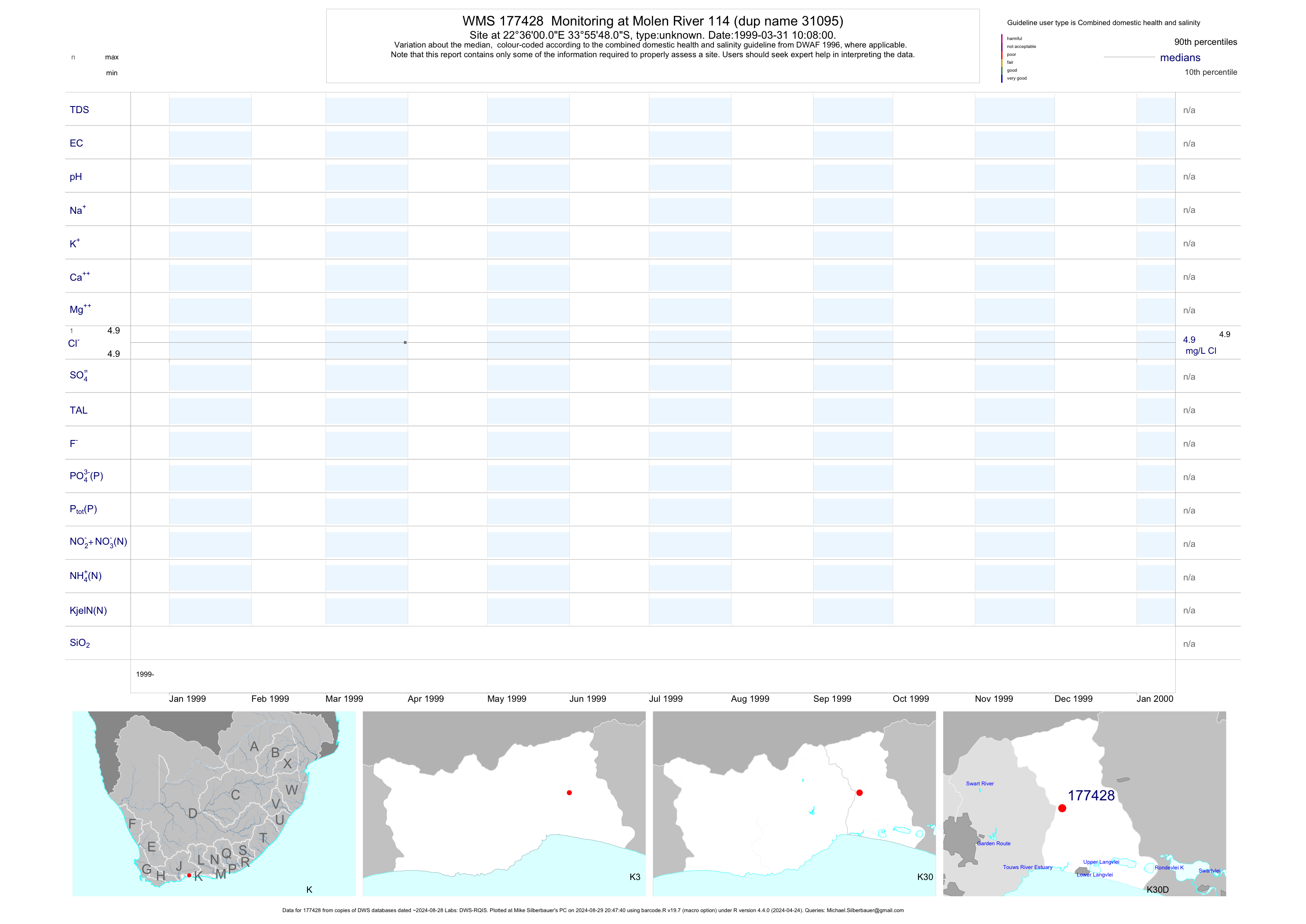
| K30 177428 | plot | data | Monitoring at Molen River 114 (dup name 31095) | unknown | 1 | 1999-03-31 | 1999-03-31 | n/a | 177428 | -33.93000 | 22.60000 |
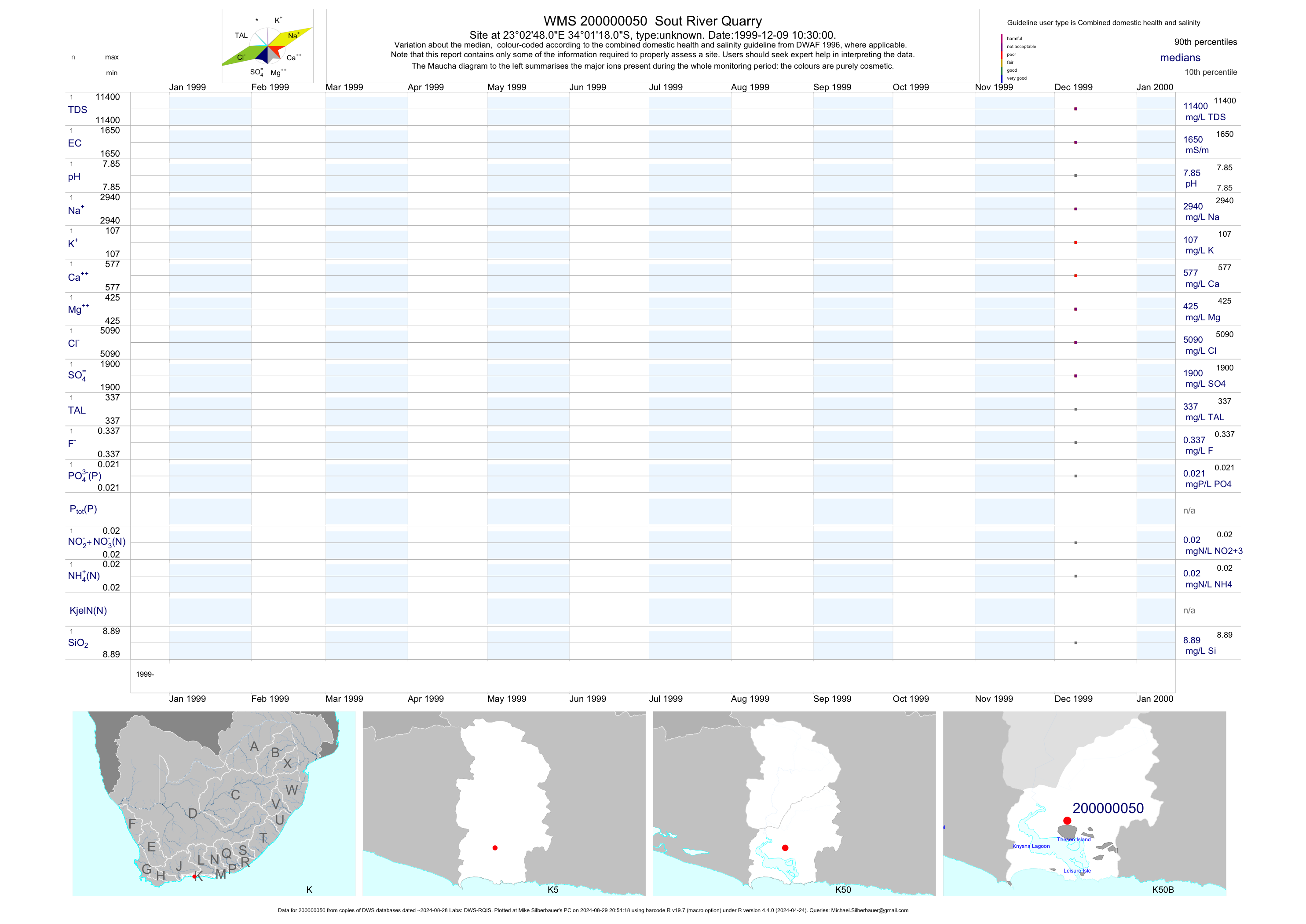
| K50 200000050 | plot | data | Sout River Quarry | unknown | 1 | 1999-12-09 | 1999-12-09 | 1650 | 2-50 | -34.02167 | 23.04667 |
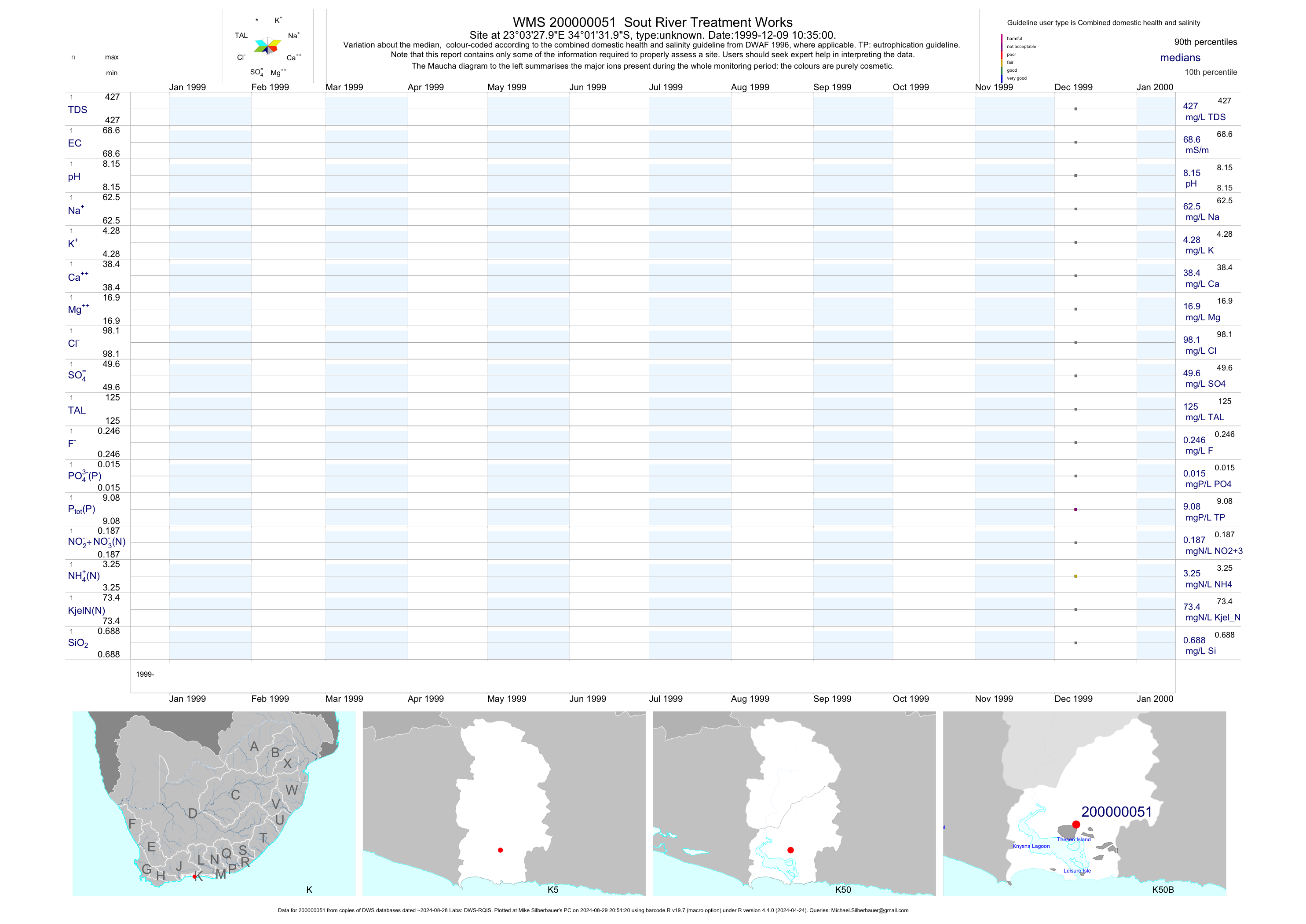
| K50 200000051 | plot | data | Sout River Treatment Works | unknown | 1 | 1999-12-09 | 1999-12-09 | 69 | 2-51 | -34.02556 | 23.05778 |
| K60 101204 | plot | data | Voeghs Kraal (dup name 6785) | unknown | 1 | 1993-10-02 | 1993-10-02 | 16 | 101204 | -33.79778 | 23.17972 |
| K60 101205 | plot | data | Voeghs Kraal (dup name 6786) | unknown | 1 | 1993-10-11 | 1993-10-11 | 24 | 101205 | -33.77917 | 23.15222 |
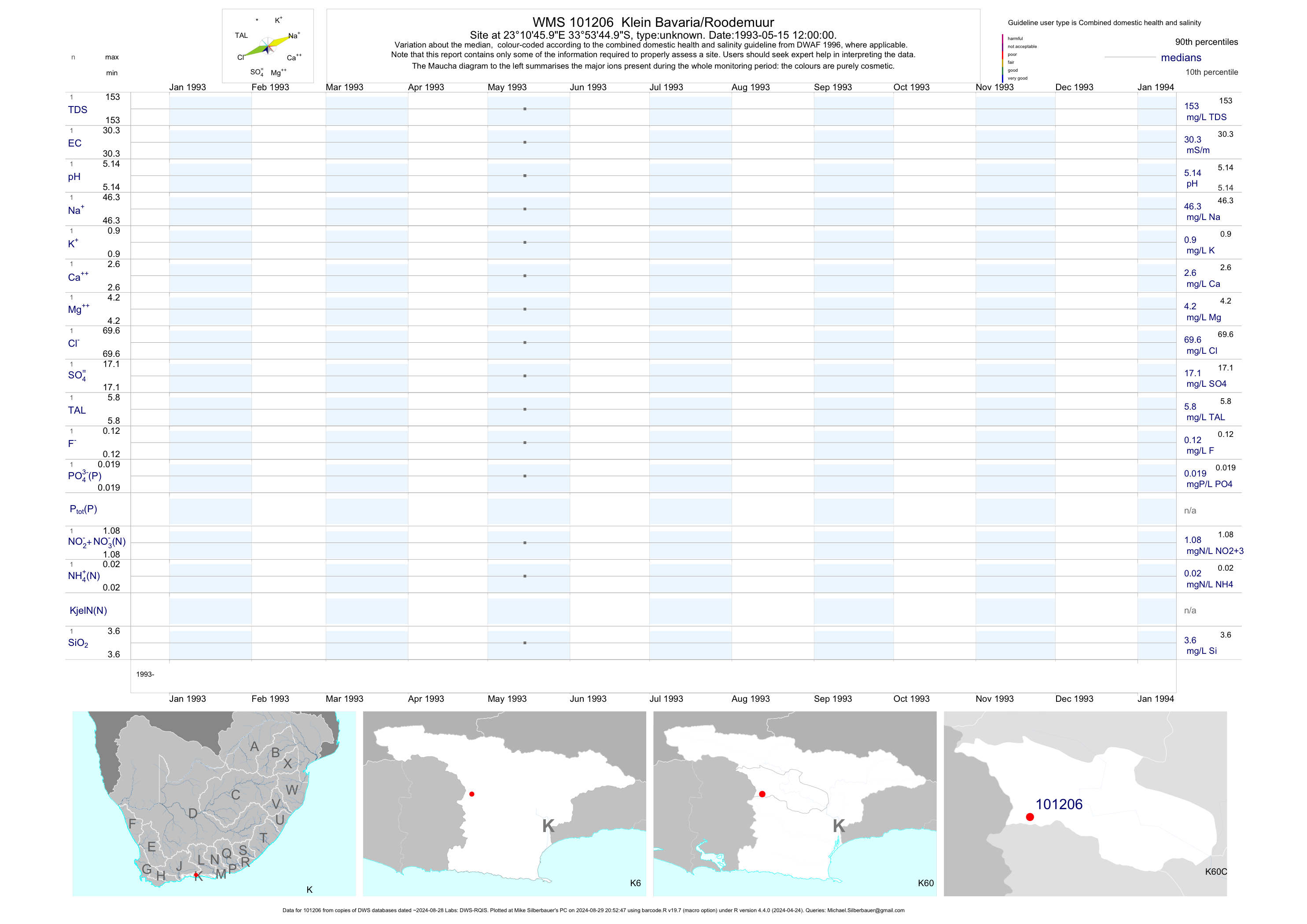
| K60 101206 | plot | data | Klein Bavaria/Roodemuur | unknown | 1 | 1993-05-15 | 1993-05-15 | 30 | 101206 | -33.89583 | 23.17944 |
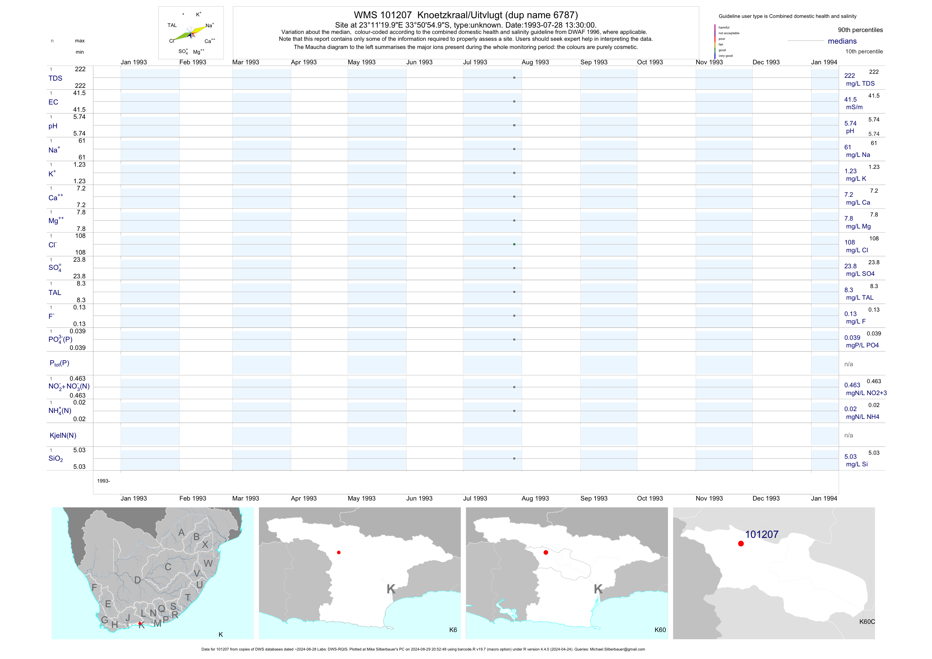
| K60 101207 | plot | data | Knoetzkraal/Uitvlugt (dup name 6787) | unknown | 1 | 1993-07-28 | 1993-07-28 | 42 | 101207 | -33.84861 | 23.18889 |
| K60 101208 | plot | data | Sonskyn/Buffels Nek Forest Reserve | unknown | 1 | 1993-05-04 | 1993-05-04 | 21 | 101208 | -33.89444 | 23.16111 |
| K60 101209 | plot | data | Annex Vlugt (dup name 6788) | unknown | 1 | 1993-10-02 | 1993-10-02 | 26 | 101209 | -33.80611 | 23.18028 |
| K60 101215 | plot | data | Smal Deel | unknown | 1 | 1993-08-04 | 1993-08-04 | 17 | 101215 | -33.83889 | 23.12222 |
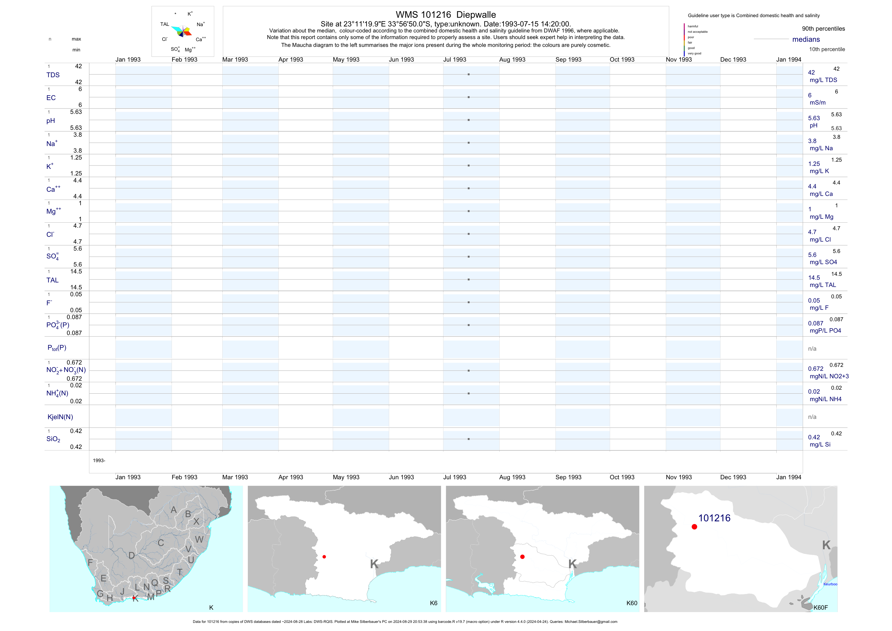
| K60 101216 | plot | data | Diepwalle | unknown | 1 | 1993-07-15 | 1993-07-15 | 6 | 101216 | -33.94722 | 23.18889 |
| K80 101351 | n/a | n/a | Geelhoutboom (dup name 6873) | unknown | 1 | 1994-09-01 | 1994-09-01 | n/a | 101351 | -34.09556 | 24.39500 |
| K90 101352 | n/a | n/a | Assegaaibos (dup name 6874) | unknown | 1 | 1994-09-01 | 1994-09-01 | n/a | 101352 | -33.94361 | 24.31528 |
| K90 101394 | plot | data | Esschenbosch (dup name 6900) | unknown | 1 | 1995-02-13 | 1995-02-13 | 41 | 101394 | -33.93806 | 24.41667 |
| K90 101395 | n/a | n/a | Esschenbosch (dup name 6901) | unknown | 1 | 1995-02-13 | 1995-02-13 | n/a | 101395 | -33.93806 | 24.41806 |
| K90 101396 | plot | data | Esschenbosch (dup name 6902) | unknown | 2 | 1995-02-13 | 1995-02-13 | 32 | 101396 | -33.95000 | 24.40778 |
| K90 101397 | plot | data | Esschenbosch (dup name 6903) | unknown | 1 | 1995-02-13 | 1995-02-13 | 29 | 101397 | -33.94889 | 24.44917 |
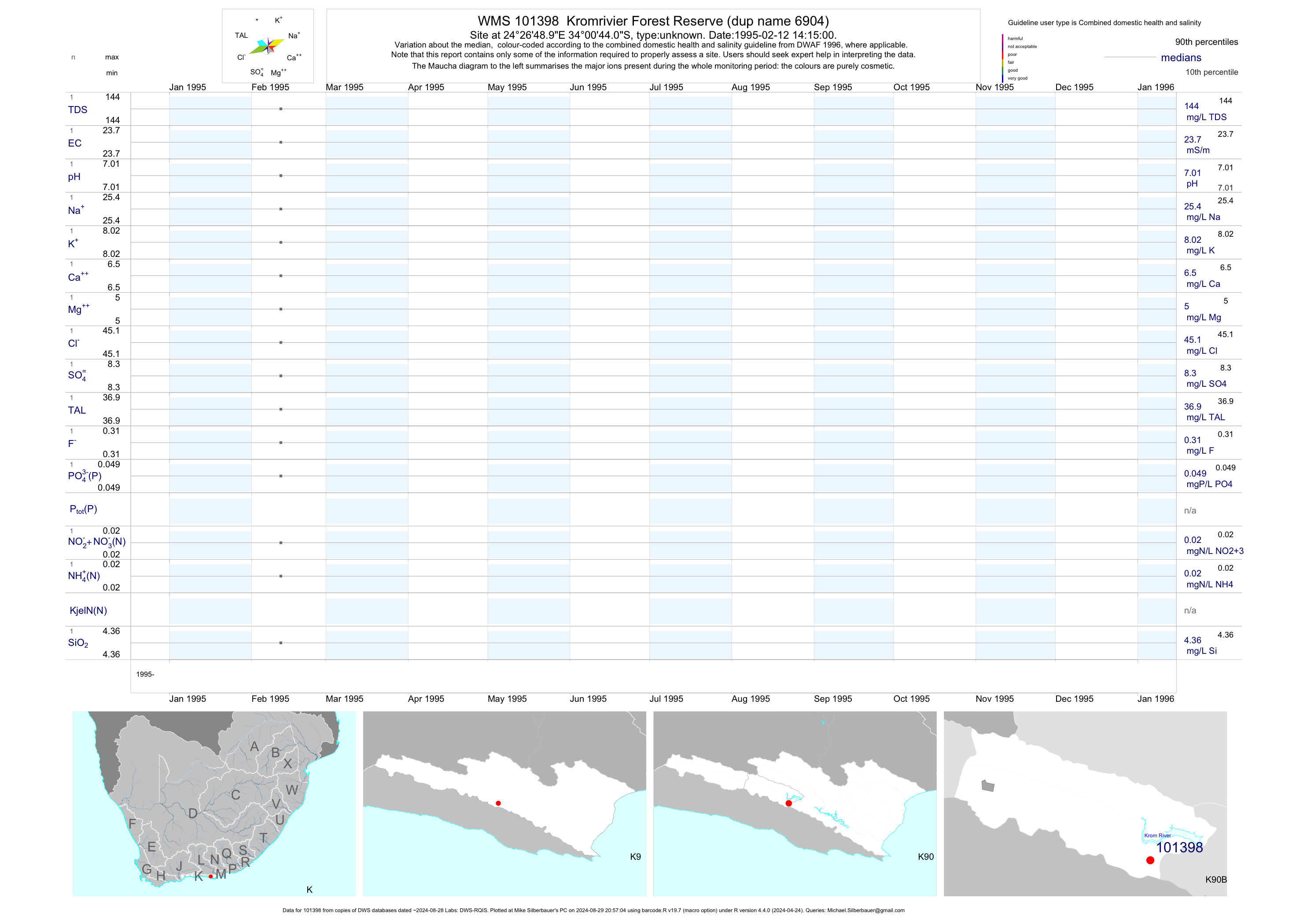
| K90 101398 | plot | data | Kromrivier Forest Reserve (dup name 6904) | unknown | 1 | 1995-02-12 | 1995-02-12 | 24 | 101398 | -34.01222 | 24.44694 |
| K90 101401 | plot | data | Wolwekraal (dup name 6907) | unknown | 2 | 1995-02-14 | 1995-02-14 | 44 | 101401 | -33.87278 | 24.33222 |
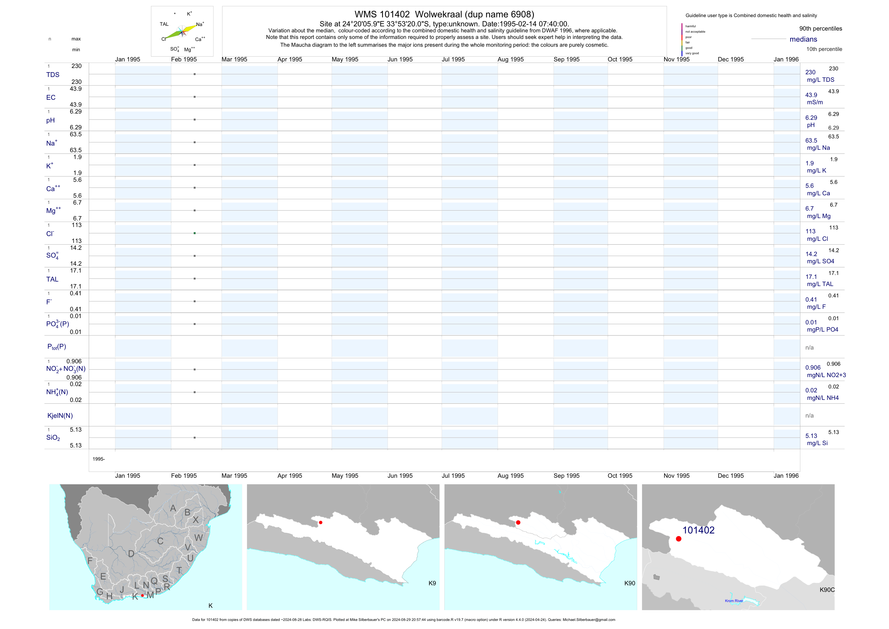
| K90 101402 | plot | data | Wolwekraal (dup name 6908) | unknown | 2 | 1995-02-14 | 1995-02-14 | 44 | 101402 | -33.88889 | 24.33500 |
| K90 101403 | plot | data | Wolwekraal-Oos (dup name 6909) | unknown | 2 | 1995-02-14 | 1995-02-17 | 62 | 101403 | -33.91556 | 24.36306 |