|
Area Description
The area under investigation is the entire Luvuvhu and Letaba Water Management
Area (WMA) and parts of the adjacent WMAs. The Luvuvhu/Letaba WMA is located
adjacent to and shares watercourses with Zimbabwe and Mozambique, and the
Limpopo River demarcates the northern boundary of the WMA. The Kruger National
Park (KNP) lies along the eastern boundary, and occupies approximately 35% of
the WMA.
The main rivers in the WMA are the Luvuvhu, Shingwedzi and Letaba rivers, which
all flow in an easterly direction through the Kruger National Park and into
Mozambique before discharging into the Indian Ocean. The Shingwedzi River first
flows into the Rio des Elephantes (Olifants River) in Mozambique, which then
joins the Limpopo River. The two main tributaries of the Letaba River, the Klein
and Groot Letaba, have their confluence on the western boundary of the Kruger
National Park, whilst the Letaba River flows into the Olifants River just
upstream of the border with Mozambique.
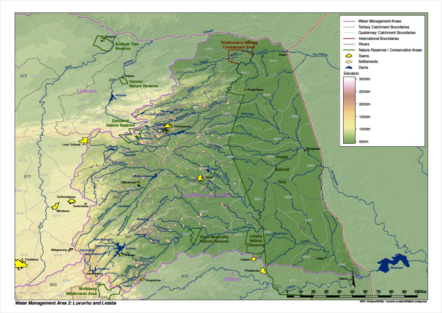
FIGURE 1: LUVUVHU AND LETABA WMA
The topography of the Luvuvhu/Letaba WMA varies from a zone of high mountains in
the west through low mountains and foothills in the central part of the WMA to
the low lying plains in the east. The mountainous zone or Great Escarpment
includes the northern portion of the Drakensberg mountain range and the eastern
Soutpansberg, which both extend to the western parts of the water management
area, and the characteristic wide expanse of the Lowveld to the east of the
escarpment. The highest peaks have an elevation of more than 2 000 m above mean
sea level (msl). This zone is deeply incised by the major tributaries draining
the WMA. The low lying plains cover most of the WMA and have gentle to flat
slopes.
The main urban areas are Tzaneen and Nkowankowa in the Groot Letaba River
catchment, Giyani in the Klein Letaba River catchment, and Thohoyandou in the
Luvuvhu River catchment. Approximately 80 to 90% of the population can be
considered as rural, scattered throughout the WMA.
The mean annual temperature ranges from about 18 °C in the mountainous areas to
more than 28 °C in the northern and eastern parts of the WMA with an average of
about 25,5 °C for the WMA as a whole. Maximum temperatures are experienced in
January and minimum temperatures occur on average in July.
Rainfall is strongly seasonal and occurs mainly during the summer months (i.e.
October to March) and is strongly influenced by the topography. The peak
rainfall months are January and February. The mean annual precipitation varies
from less than 450mm on the low lying plains (northern and eastern part of the
WMA) to more than 2 300 mm at Entambeni in the Soutpansberg in the mountainous
areas (south western and north western parts of the WMA).
The average potential mean annual gross evaporation (as measured by S pan)
ranges between 1 300mm in the extreme western mountainous region and 2 000mm in
the northern and eastern areas. The highest evaporation occurs in the period
October to January and the lowest is in June.
The geology is varied and complex and consists mainly of sedimentary rocks in
the north and metamorphic and igneous rocks in the south. High quality coal
deposits are found near Tshikondeni and in the northern part of the Kruger
National Park, whilst the eastern limb of the mineral rich Bushveld Igneous
Complex touches on the southern parts of the water management area. With the
exception of sandy aquifers in the Limpopo River Valley, the formation is of
relatively low water-bearing capacity. A wide spectrum of soils occur in the
WMA, with sandy soils most common.
Population
The total population for the study area is around 1.8 million people.
Approximately 80-90% of the population can be described as rural. A large
proportion of the population depends on subsistence farming and this makes
availability of water a vital subject for consideration.
Economic activities
downstream of the Middle Letaba Dam, and particularly along the Groot Letaba and
Letsitele Rivers, as well as in the upper Luvuvhu River catchment. Vegetables
(including the largest tomato production area in the country), citrus and a
variety of fruits such as bananas, mangoes, avocados and nuts are grown. Large
areas have been planted with commercial forests in the high rainfall parts of
the Drakensberg escarpment and on the Soutpansberg.
Mining also takes place all over the study area while 35% of the study area
consists of the Kruger National Park. A significant number of people in the
catchment live subsistence livelihoods.
|