|
Area Description
The study area comprises the water resources of the Integrated Vaal River System - from Kuruman
in the west to Ermelo in the east and Johannesburg in the north to the Lesotho border in the south.
Other sub-systems that also form part of Integrated Vaal River System.
Considerable variations in climatic conditions occur over the three integrated WMAs. The Mean Annual
Precipitation (MAP) decreases from 800 mm in the Upper Vaal
to 500 mm in the Middle Vaal and 100 mm in the Lower Vaal WMA.
This tendency is reversed when considering potential annual evapotranspiration, which increases from
1300 mm in the Upper Vaal to 2800 mm in the Lower Vaal WMA.
The land use in the Upper Vaal WMA is characterised by the sprawling urban and industrial areas in the
northern and western parts of the WMA. There is also extensive coal and gold mining activities located in the Upper Vaal WMA.
These activities are generating substantial return flow volumes in the form of treated effluent from the urban areas and mine dewatering that are discharged
into the river system. These discharges are having significant impacts on the water quality in the main stem of the Vaal River, throughout all three the WMAs.
The Upper Vaal WMA is economically important, contributing nearly 20% of the Gross Domestic Product of South Africa,
which is the second largest contribution to the national wealth amongst all of the WMAs in the country. The potential for future economic growth in this WMA remains strong.
Growth will largely be attracted to the already strong urban and industrial areas in the Johannesburg-Vereeniging-Vanderbijlpark complex.
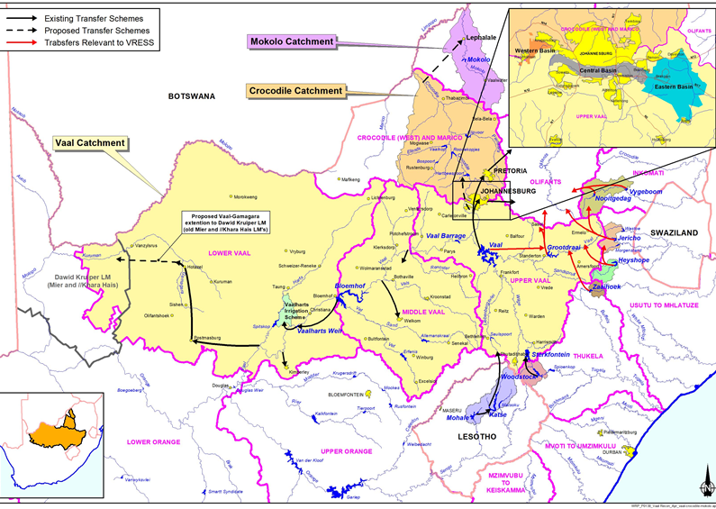
Figure 1: The study area for the reconciliation Strategy for the Integrated Vaal River System - Phase 2
|