|
|
| RHP |
South African
River Health Programme
|
State of the Rivers Report
uMngeni River and Neighbouring Rivers and Streams
|
A HISTORICAL DESCRIPTION OF THE UMNGENI RIVER
|
|
This historical description was compiled from available written and photographic records dating back to the 1600s.
|
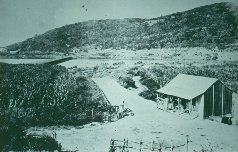
Durban Bay around 1950
|

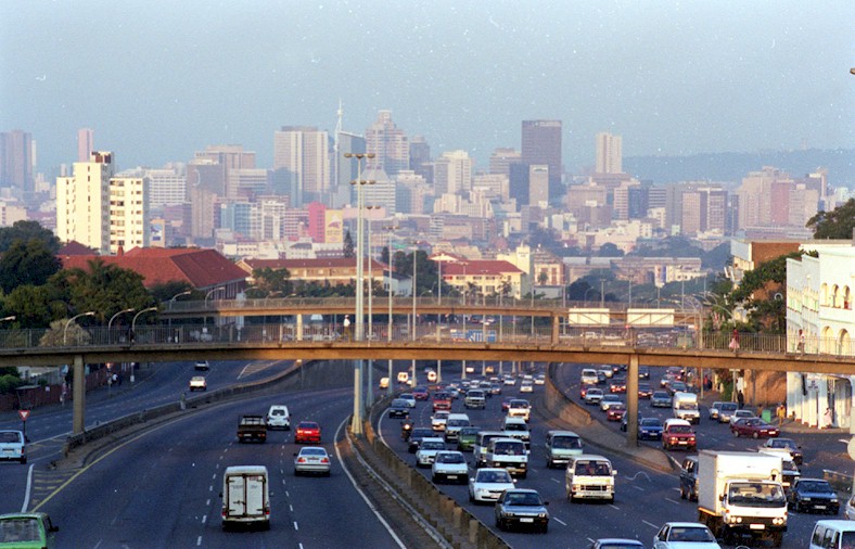
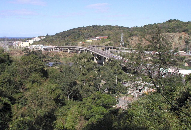
Durban Today
|
|
This report tells us about the current state of the uMngeni and uMlazi rivers. Why would it be important to examine how these rivers looked and behaved in the past? By understanding something of the historical state of these rivers, we are made aware of the goods and services they provided back then and how these may be different from the present situation. This comparison give an indication of the type of trajectory we are on in relation to our rivers so that we can try to manage, and perhaps restorethe benefits we get from them.
|
|
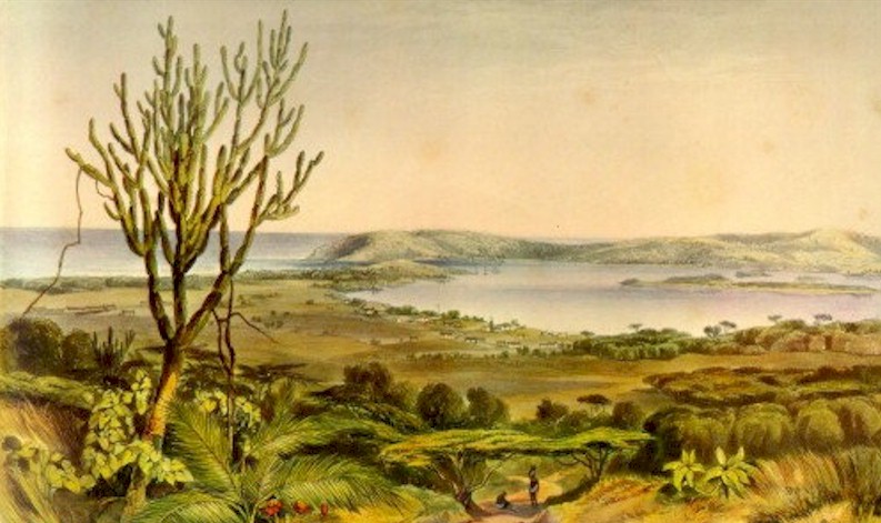
We are fortunate that the vision of various people in the 1950s and 1960s resulted in fairly detailed surveys of the uMngeni River. These were published by the CSIR and the Town & Regional Planning Commission. But, these reports document the river in an already impacted condition.
Earlier knowledge of the uMngeni River in the upper parts of the catchment is limited, other than from incidental reference made in various texts. Because of the development of Pietermaritzburg, some information on the uMsunduze is available mostly in the form of old photographs. There is considerably more information about the river estuary and its relation to Durban Bay, as this was an important resource for the local settlers in the early 1800s.
|
Lower uMngeni Bridge - 1870
|
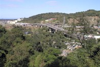
Lower uMngeni Bridge - 2002
|
|
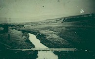
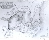
The uMngeni Estuary
Information on the meanderings of the uMngeni estuary is confusing and scant. It appears that the position of the estuary has changed repeatedly, moving not only north and south along the coast, but at times the uMngeni River flowed directly into Durban Bay.
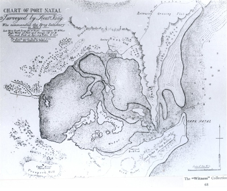
Russel (1899) noted that the name uMngeni means "River of Entrance" because the ancient uMngeni flowed into Durban Bay via a low lying area known as "Eastern Vlei". But, a map of Durban drawn by Lt. King in 1823 shows the river clearly entering the sea in approximately its current position, with little sign of a pathway to the Bay.
A 1909 Mercury Pictorial (9th September) reported that the estuary had marched "three miles" from its present position towards Durban. Concern was expressed and the estuary was manually redirected towards its current position. This probably happened repeatedly.
From and old account written in the late 1600s, the author describes what is now Durban where the mouth of the river is clearly the Bay itself: "Neither is there any want of water, for every hill affords little brooks, which glide down several ways, some of which meet by degrees, which make up the river of Natal (uMngeni River), which dischargeth itself into the East Indian ocean, in latitude 30 S, where it opens pretty wide, and is deep enough for small ships. But at the mouth of the river is a bar, which has not above 10 or 11 feet of water on it in a spring tide, though within there is water enough. This river is the principal of the country of Natal, and has lately been frequented by some of our ships, particularly by a small ship that Captain Rogers owned. (Dampier's Voyages - British Museum - repeated in Bird 1888).
Accordingly to Hattersley (1936) who described Durban in the 1800s: "Then as now, the beach (in Durban Bay) was the centre of amusement. The boys fishing for eels in the big pond, formed in the "dip" in West Street by the stream which originally connected the Umgeni with the bay, provided favourite sport in the days before building operations covered the swampy ground (today the dip in West St is between Field St and Gardiner St). At low spring tide, it was very nearly possible to walk on dry sand across to the Bluff, and the channels could be easily waded by those who did not fear sharks. North of the Point, the little-used ocean beach swarmed with white crabs." Hattersley, MA (1936) .
Cooper & Mason (1987) say the following of the meandering estuary: "�the uMngeni flowed southward between the Berea Ridge and a line of coastal dunes before discharging into Natal Bay. This former course is marked by thick estuarine deposits beneath Durban and is visible on satellite images of the Natal coast. In a chart of 1860 this former course of the uMngeni is marked by a series of marshes."
In 1856 a great flood laid waste the Springfield Estate along the Umgeni, which had grown the first Natal grown sugar for sale on the Durban market. (Hattersley 1936)
Description of Durban Bay
Following is an extract from a dispatch from Commander Simon van der Stel (1690) - reporting on the search by the ship de Noord for the wrecked sailors from the ship Stavenisse. When they got to the Bay of Natal they found some of the crew of the Stavenisse. The report describes the Bay as follows: "There are many dense forests with short-stemmed trees; but at the bay of Natal are two forests, full a "mijl" square, with tall, straight and thick trees, fit for house or ship timber, in which is abundance of honey and wax: but no wax is to be had from the natives as they eat the wax as well as the honey. ...In the rivers are eels and congers, and in the bay of Natal king's fish and sun-fish, besides all kinds of fish known in India and here, as may be further seen from the annexed account taken down from the mouths of our men." (in Bird, 1888)
Thomas Green was an immigrant to Natal in 1843 and wrote the following description of his arrival in Durban.(in Hattersley, 1936)
|
|
"I stood in amazement at the grandeur of the scene. Everything was primitive; the hands of man had not defaced it. The inner Bay was like a sheet of silver, the home of white fowl that man had never frightened. I thought the Bay the most beautiful sight that I had ever seen. But the sunset that evening in May with the golden tints beggars any description that I can give. I have never seen the like before in Ireland, where I come from. The beautiful Berea untouched, all one sheet of evergreen, and the home of elephants and other animals."
|
| The uMngeni River in Durban
The town that became Durban developed on the flat plain at the base of the Berea. The scant vegetation rapidly became a mass of loose blown sand, which drove the inhabitants to distraction. The Anglican Bishop of Natal, Bishop Colenso wrote the following account of the drinking water in the town: "A greater evil in Durban is the water, which is taken usually from wells, that are not sunk deep enough, and consequently abound with decaying vegetable, if not animal matter, and innumerable animalcules and worms�..At present, the remedy is to drink rain water, or the water of the Umgeni River, which is brought by carriers a distance of four miles and is excellent. Indeed, had the Dutch founded the town of Durban, as they did that of Maritzburg, they would long ago have had the Umgeni pouring its beneficent streams through every street, and bringing health and cleanliness to every door. How long will it be before the public spirit of Englishmen will achieve this?" (Durban's water supply was not materially improved until HW Currie sunk a well in 1879 (Curries Fountain) in the vicinity of the present Botanic Garden). Bishop JW Colenso (1854) in Hattersley (1936)
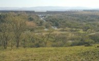
Alfred Delegorgue describes going on a hippo hunt in the Seekoei Vlei area, now dominated by the N2 road, sewage works and a new garage development. All that remains of what was the scene described below, are some reeds and a small polluted lake. The rest of the area is drained by a system of canals. "After we had crossed the sandy bed and forded the beautiful river (the uMngeni), another challenge faced us in the guise of a steep and difficult ascent on the other side. Without benefit of roads, we reached the summit of this hill and then skidded down towards a pretty peninsula surrounded by a deep lake, where the large heads of hippopotamus could be seen here and there on the surface of the water�.we pitched our tent on the inviting green promontory � the slope was so gentle, the grass so short, the top of the little hill so well placed between the crocodiles and hippopotamus �. Mosquitoes attacked us in their millions, finding their way under out bed clothes which gave no protection, invading our noses, our ears, our eyebrows and our beards." (1848 - Delegorgue).
|
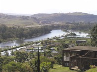
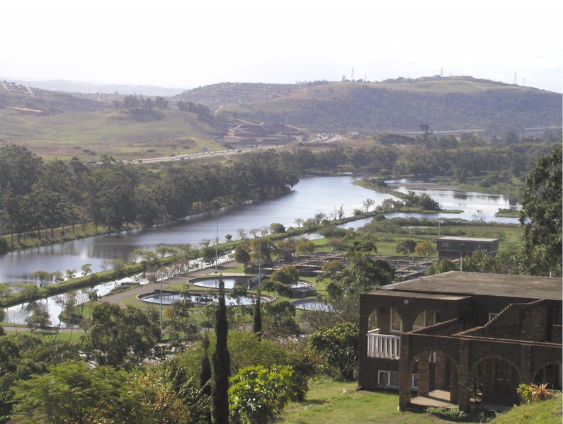
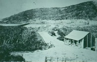
Seekoei Vlei - 2002
|
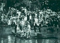
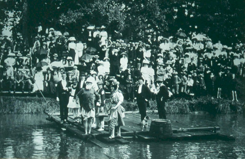
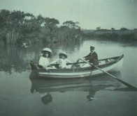
Swimming gala in the uMsunduze River,
around 1909
|
|
Pietermaritzburg
The town of Pietermaritzburg was distinguished in the early 1840sby the furrows of flowing water that carried water from the Little Bushmans River (the 'Dorpspruit' which carried the same name as uMsunduze) down the length of all of the streets .This water was abstracted from a point just below the entrance to the Botanical gardens to a point at the top of Longmarket St for a period of 40 years (Meineke and Summers, 1983). Each property owner was responsible for maintaining the furrow past his/her property, and the custom was to draw water into barrels in the early morning of each day, when water quality was likely to be t its best. This water provided an important service to the citizen, even though pedestrians occasionally fell into them by accident at night! Crabs abounded in these furrows, to the delight of the town's children. Syringa trees were originally planted to indicate the boundaries of the streets, and after all these years have become an invasive problem.
The furrows were converted into a piped supply in 1881 and in time, the waters of the Dorpspruit became insufficient to provide for the growing town. Catchment management in the Dorpspruit became an issue in 1887 when the reservoir caretaker was appointed to protect the water supply via protection of the vegetation. Water was also taken from the Town Bush stream where in 1901 a water treatment plant was built at the confluence with the Chase Valley Stream. The first water was pumped from the uMsinduze in 1903 and by the following year sights were set on the tributaries in the Henley area, which provided water into a pipeline. It was only in 1924 that a dam was built on the uNsindusaan River. Thi sdam collapsed in the year of completion, but was rebuilt within a few years (1927). Henley dam was built on the main uMsunduze and was completed in 1943.
Pietermartzburg's first sewer discharge in1863 was into the uMsunduze below old jail in Burger St. this created water quality problems within the town until a main was installed in 1905 to carry the sewage to below the town.
The uMsunduze River was the venue for swimming activities in Pietermaritzburg. Each February the annual swimming gala was held, including a race of 300m part of which was swum upstream. In 1896 the event was interrupted by a sudden soate that washed away the officials' raft and the military marquee on the banks, table, chairs and all.
A severe drought in Pietermaritzburg (489mm rain - 53% of average) during 1931 coupled to the great Depression, was accompanied by an outbreak of malaria that moved inland from the coast.
In 1875 the uMsunduze in Alexandra Park was shaded by large weeping willows (Hattersley, 1936). Bishop Colenso noted in 1854 that the willow trees were only eight to ten years old, and were already "very fine in their growth".
|
Footbridge between Chapel Street and Alexandra Park - 1866
|

The same site today
|
|
A further report notes that: "There is no record of when the first weeping willow trees were planted in this part. The original cutting, which became the parent tree of all weeping willows in South Africa was taken from a tree at Napoleon's grave at St. Helena." Miss Smythe-History of Nottingham Road 1850-75 (in Hattersley, 1936).
The pictures of the footbridge just below Chapel St crossing to Alexandra Park give an interesting insight into the changes in vegetation that have taken place over the years. Note how the banks of the river have overgrown with exotic trees, resulting in the destabilisation of the soil and subsequent incision of the river deeper into the ground.
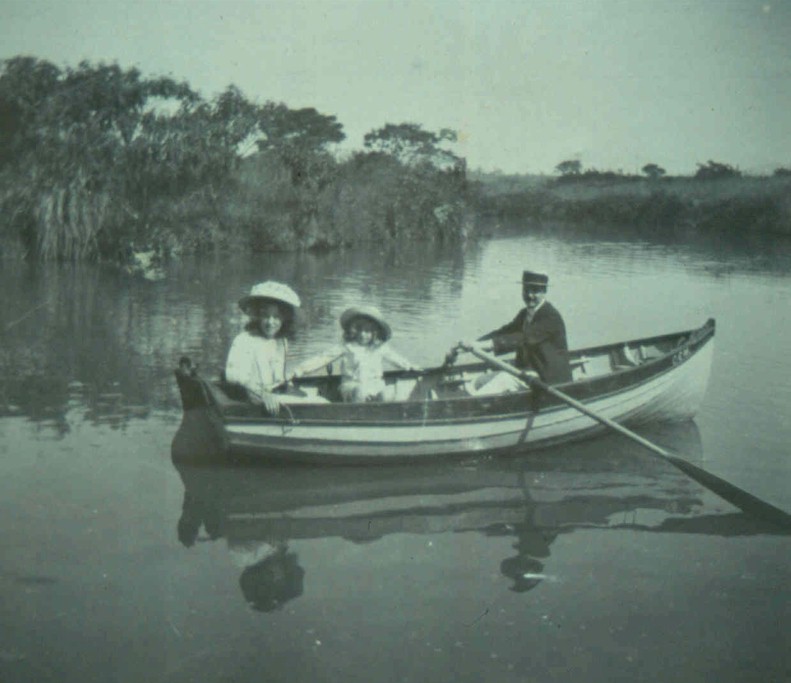
Boating on the waters of the uMsunduze became a popular pastime from a weir below Musson's Tea Room up towards Commercial Rd. At the time it was stated "this stretch is today one of the prettiest river stretches in South Africa and is one of the city's best attraction".
|
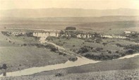
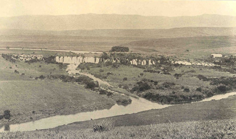
Albert Falls - 1912
|
"In September 21, 1853, snow lay half-way down the Town Hill, the only time I have seen it there. In April 1856, there was one of the highest floods ever known in the colony, and the bridge over the Umsundusi was washed away." - Rev. James Green, (in Hattersley 1936)
|
Albert Falls - 1952
|
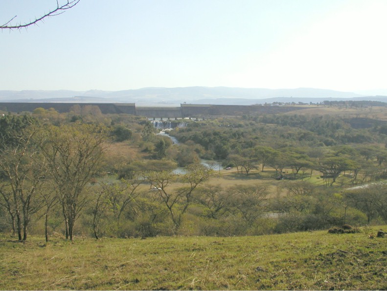
Albert Falls - 2002
|
"In 1868, when I was nine, we children were taken to see Victoria Bridge, over the Umsundusi, which had collapsed in the centre through the river raging far over its banks in the floods. A drift was made above where the bridge was, which was used for traffic�..in Loop Street, near Buchanan Street, was a mill, Van der Plank's I think it was called. A very strong stream of water leading into Burger Street turned the wheel. Often and often, we children watched the mealies being ground into meal."
Mrs. G. Lamond Narrative of Family History, Natal Archives - Hattersley)
|
|
|
Further stories from Pietermaritzburg
"At the bottom of the town was very good snipe shooting, in the "vlei" - a marsh. Piet Otto, lived in his farm 14 miles from headquarters, and possessed 17 000 acres of fenced land (now Otto's bluff). The Umgeni River ran through the farm, very deep in some places. He allowed me to shoot where I liked on condition that I did not shoot his pet hippos. There were seven; but one year he had a contract to supply the troops with forage. I got a note sent express, saying "for goodness' sake come and help kill the sea cows, they are destroying my forage and I cannot carry out my contract". �Eventually all but two were shot; these two had enough of it and went away to pastures new. GA Lucas, (in Hattersley 1936)
"In the early days of the town, game was very plentiful in the neighbourhood, and besides this, there were lots of leopards and hyenas. The latter frequently prowled about the town.." Pistorius, CW. 1845. (in C. Bird papers)
"Our shooting ground consisted of all the land in sight of the city, including all the town lands, which supplied us with riet buck, oribi, duiker and paauw. Fox Hill was named by myself and others, who at times got up a scratch pack of dogs, immaterial what breed so long as they gave us a run, after jackal." JW Shepstone (in Hattersley, 1936).
Pietermaritzburg in the 1800s was not the green vista that it is today. One early description noted "the country around Pietermaritzburg is almost entirely destitute of wood, except in some of the mpountain kloofs, giving the whole neighbourhood a wild, yet monotonous appearance." This cam be seen in many paintings and photographs of the old city.
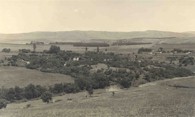
Upper uMngeni River
Only old photographs exist to show how the uMngeni River has changed over the years. A series of pictures of Albert Falls illustrates how development has changed the river environment from an extensive grassland area with grassy with grassy riparian vegetation, to one covered with thick woody vegetation, some indigenous and some exotic, a dam and railway line . The area has little resemblance to the original scene, which will today be reflected in the much altered river ecology.
|
|
The wildlife in the 1800s
Interesting species were recorded by Wahlberg (1838-1856) and Delegorgue (1838 - ) both of whom were avid collectors of specimens. Wahlberg sent several thousand of these, from insects to hippos, to Sweden where many are still preserved. Many of the species below we would hardly associate with these areas any more.
|
Durban
Side necked turtles (Pelomedusidae) in the Bay
Fiddler crabs
Pythons were common
Great Snipe (not seen for many years)
Black breasted snake eagle
Woolly necked stork
Cuckoo hawk
Bateleur eagles were common
Goliath heron
Giant eagle owl
Maribou
Red duiker
Southern Reed buck
Leopard
Buffalo
Lion
Elephants in herds of more than 1000
Enormous swarms of locusts
|
uMngeni river
Maribou stork
Saddle billed stork
Marsh owl
Mayflies were a staple diet of Bustards and Black kite
Ratel/honey badger
Wattled crane (rare)
Samango monkey
Guinea fowl
Green dove
Crested guinea fowl
Short eared owl
Bushbaby
Hippos and crocodiles in Seekoei Valley
|
uMlazi estuary
Namaqua dove
Jacana
Extensive marsh
Cato Ridge
Lions on the upper uMlazi (Cato Ridge area) - with innumerable bugs which prevented sleep
Glossy ibis near Cato Ridge
|
Pietermaritzburg
Mozambique spitting cobra
Klipspringer
Grey Rhebok
Riet buck (Southern Reed buck)
Oribi
Duiker
Jackal
Leopard
Hyena
Ground hornbill
Snipe
Bald Ibis
Blue swallow
Hares
Cane rats were common on the banks of the uMsunduze
|
|
Local cultural history
The Zulu people acknowledge water spirits including the river snake, the 'snake of the waters that gives life'. This belief system unites people, both the living and the dead, with natural forces, the non-human spirit world and the supreme deities. The ideal pool for ceremonies involving the river snake (e.g. diviner submergence) contains 'living water', and usually is below a waterfall where the water is turbulent and deep.
|
|
|
Reeds are also a key symbol for the Zulu people, as they believe that their people emerged from a bed of reeds in ancient times. The reed mat is thus an essential part of the diviner's habit, and is directly linked to its association with water, healing and creation.
In some areas of KZN it is believed that the heavenly princess, iNkosazana has rest days where she needs to have the river to herself. Accordingly the use of the river on her day - lesuku leNkosazana (Mondays and Saturdays), is strictly prohibited.
In the uMlazi River, river ceremonies are conducted several times a year by about 78% of the Salem community. These include:
Umsenga - the reed dance where young girls cut river reeds and take them to the Inkosi's house as a gesture of honour.
Unomkhubulwane (Goddess of Water) - seeds are thrown into the river to ask the Goddess for blessings and a good harvest.
Weddings - the bride will bath in the river prior to the wedding ceremony, to remove evil spirits and bless the marriage.
Besides bathing, ceremonial use of the river is its most common use, with the supply of building materials, recreation and clothes washing being of lesser importance.
A degraded river reduces the acceptability of the river for ceremonial purposes. Almost all of the people in Salem acknowledge that respect for the river and its attributes for cultural and religious ceremonies are diminishing.
|
|