STRATEGIES AREA
The study area includes the Water Management Areas (WMA) of Limpopo, Luvuvhu and Letaba, Crocodile (West) and Marico, and Olifants as established in
the first edition of the National Water Resource Strategy (NWRS-1, 2004). The study area encompasses the entire province of Limpopo,
the eastern part of the North West province and the northern parts of the Gauteng and Mpumalanga provinces as shown on Figure 2.
All four of the WMA’s included in this study area share water resources with the neighbouring countries of Botswana, Zimbabwe and Mozambique.
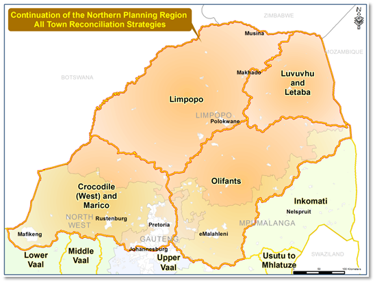 Figure 2: Study Area for the All Towns Reconciliation Strategies for the Northern Planning Region
The major cities and towns within the study area, to name but a few, are: Johannesburg, Pretoria, East Rand, Mahikeng (Mafikeng), Rustenburg,
Brits, Polokwane (Pietersburg), Musina, Thabazimbi, Thohoyandou, Giyani, Modimolle (Nylstroom), Bela-Bela (Warmbaths), Burgersfort and eMalahleni (Witbank), etc.
The driving forces behind development and economic growth within these WMAs are urban development, industrialisation and power generation, agriculture,
eco-tourism and mining that place a high demand on the availability of water sources. Livestock farming also occurs in some parts and a large proportion
of the population residing within the Luvuvhu and Letaba WMA depends on subsistence farming. However, the development and implementation of water
conservation and water demand management (WC/WDM) programmes are lacking in the majority of the towns located within the WMAs.
According to the DWS Registered List of Dams (October 2011), there are 722 dams located across these WMAs – serving the domestic,
irrigation and/or industrial and mining sectors. Of these, 87 dams serve the domestic or municipal sector (may be shared by other sectors),
and 15 are classified as large. Some of the most prominent dams in the study area include the Hartbeespoort, Molatedi, Roodekopjes, Vaalkop,
Mokolo, Glen Alpine, Nandoni, Vondo and De Hoop (completed in 2013).
Groundwater is used in many areas (predominantly rural areas with scattered villages and households) for water supply because of the relatively
small water requirements. The groundwater potential in the study area vary, but appears to be predominantly of minor to major potential (high
yielding water of good quality). Some rudimentary groundwater supply areas do experience problems with water quality and treatment is required.
The major rivers include the Crocodile (West), Marico, Limpopo, Matlabas, Mokolo, Lephalala, Mogalakwena, Sand, Nzhelele, Mutale, Luvuvhu, Letaba,
Elands, Wilge, Steelpoort and Olifants. The Limpopo River is shared with Botswana and Zimbabwe (contiguous – being a country boundary) and Mozambique
(trans-boundary – across country boundaries). It is subject to the 1997 United Nations Convention on the Law of the Non-Navigational Uses of International
Watercourses and is managed through the Revised Protocol on Shared Watercourses in the Southern African Development Community (2000).
|