| RHP |
South African
River Health Programme |
State of the Rivers Report
Crocodile, Sabie-Sand & Olifants River Systems |


|
|
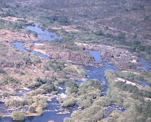
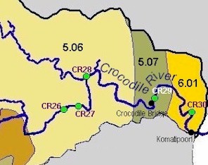
The Crocodile River System Ecoregion 5.06, 5.07 & 6.01 | ||
|
Ecoregion and River characteristics Ecoregion 5.06 Typical of the Lowveld proper (300-600 m above mean sea level), this ecoregion has flat to moderate relief, lower rainfall (400-800 mm per year) and high temperatures (20-22°C). These conditions, together with shallow black, brown or red clayey soils, produce sweet lowveld bushveld. The river is 40-50 m wide, slow flowing and with mostly large sandy pools. Ecoregion 5.07 Lowland plains (200-400 m above mean sea level) and sweet lowveld bushveld are characteristic of this region, where conditions are warm (often above 22°C) and relatively dry (400-600 mm of rainfall per year). |
||
|
||
|
||
|
Drivers of Ecological Change (Land-use activities)
Ecoregion 5.06
The river forms the southern boundary of the Kruger National Park, which gives it a high conservation status. At the same time, the southern bank of the river is heavily utilised. Vegetation removal for citrus and sugar cane farming as well as tourist lodges have modified large parts of the southern bank.
Ecoregion 5.07
This ecoregion experiences the same pressures as ecoregion 5.06. In addition, the cumulative effect of water abstraction, primarily for irrigation purposes, often results in lower than desired flow. This has a negative impact on the availability and diversity of in-stream habitats as well as overall water quality. This impact is, in turn, affecting the composition of invertebrate and fish communities.
Ecoregion 6.01
The driving forces in this ecoregion are similar to those in neighbouring ecoregions 5.06 and 5.07. The Crocodile River flows into Mozambique at Komatipoort, and South Africa has an obligation to allow sufficient flow in the river at this point. This places further restrictions on the volume of water that can be abstracted, and thus increases the pressure on the resource to meet all the needs.
Desired Ecological State and Response by Resource Managers
Given the mandate of the Kruger National Park as well as the strategic importance of development for tourism in this part of the catchment, the desired state of the Crocodile River is
natural
to
good
. To be realistic, a goal of a
good
state is suggested for the medium-term (5 to 10 years), with an ultimate aspiration to achieve a
natural
state over the long term.
The most important management action for achieving a good state is to ensure ecologically sound flows in this section.
Developments within the riparian zone of the river’s southern bank should be monitored to ensure sustainable utilisation and protection of a buffer area. In particular, sugar cane is planted right to the water’s edge in some areas, and this should be replace by natural vegetation to preserve the stability and functionality of the banks.
|
||


|