|
Ecoregion and River Characteristics
This is an area of flat grasslands with rolling rocky zones on top of the escarpment (1 500-1 750 m amsl). Sandstone and shale harbor rich coal deposits, covered by deep, red to yellow sandy soils. Wetlands that overlie these deposits are threatened by potential mining activities. Precipitation is 600-800 mm per year, frequently in the form of summer storms. Mean annual temperatures range from 14-16°C.
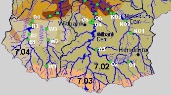
The Wilge, Bronkhorstspruit and Klein Olifants Rivers are tributaries of the Olifants River that, together with the Olifants River, originate in the Highveld grasslands in these areas. The river structure varies from a narrow channel with no definite riparian zone up to a 20-30 m wide channel with well-defined riparian habitat. The Witbank and Doringpoort Dams are in this section of the Olifants River.
|
|
Present Ecological State
|
|
|
The in-stream and riparian habitats in these ecoregions show a
fair
to
unacceptable
state, with the general condition being
poor
and
fair
in ecoregions 7.02 and 7.04 respectively. Biological communities also reflect
fair
to
unacceptable
health, with the streams in ecoregion 7.04 in a slightly better state than those in ecoregion 7.02.
|
|
|
Drivers of Ecological Change (Land-use activities)
|
|
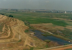
Mining, predominantly for coal, and other industrial activities in this area are the main contributors to poor in-stream and riparian habitat conditions. In-stream conditions are impaired by poor water quality, where acid leachate from mines is a primary contributor. Low pH (high acidity) and high concentrations of dissolved salts are characteristics of streams in this section.
Stream diversions occur as a result of agricultural and mining activities. In some parts, access roads, mostly related to mining and industrial activities, have resulted in
|
|
|
|
severe disturbance of riparian habitats, and increased erosion of both land and riverbed.
In some places the riverbeds are eroded down to the bedrock, leaving little suitable habitat for fish and aquatic invertebrates. Alien plants such as wattles also occur within the riparian zone, competing with indigenous vegetation and reducing available water in the riparian zone. Overgrazing occurs in some areas.
Desired Ecological State and Response by Resource Managers
The upper reaches of the Olifants River system are heavily utilised. Yet, in the interest of downstream users, and to ensure sustainable development of the entire catchment, the ecological state of this section cannot be compromised. A short-term management state of
poor
may be the only realistic option for streams within ecoregion 7.02. However, the long-term goals should be to aim for a
fair
state. Both in-stream water quality and riparian conditions will need to improve to achieve this. The effluent from mining and other heavy industry will have to be treated before release into the river, and clearing of alien vegetation in the riparian zone is a priority.
For ecoregion 7.04, the recommended management state is
fair
. Rehabilitation and protection of the many important wetlands in the upper part of this ecoregion are management priorities.
|
|


|
|


