| RHP |
South African
River Health Programme |
State of the Rivers Report
Crocodile, Sabie-Sand & Olifants River Systems |


|
|
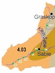
The Sabie-Sand River System Ecoregion 4.03 |
||
|
||
|
||
|
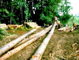
Desired Ecological State and Response by Resource Managers The headwaters of the Sabie River are important wetland areas that regulate water flow and quality. These areas provide habitat for many species of animals and plant. For this reason, a natural health state should ideally be maintained. However, in view of the extensive forestry activities and occurrence of alien vegetation and trout, a good state is recommended as a more pragmatic goal.
|
||


|
||