|
The Crocodile River System
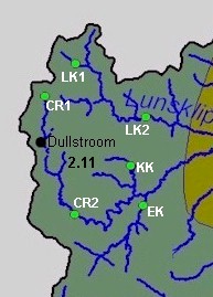
Ecoregion 2.11
|
|
Ecoregion and River Characteristics
The ecoregion is characterised by plains with moderate slopes and mountain or highveld grasslands on deep red to yellow sandy soils, overlying granites, quartzites and basalts. These are relatively high altitude areas, ranging from 1 000 to 2 000 m above mean sea level (amsl) with an average rainfall of 800 mm per year and mean annual temperatures of 12-14 °C.
|
|
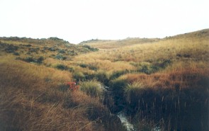
The Crocodile River rises in the Steenkampsberg Mountains at an altitude of more than 2 000 m above sea level. The sources of the streams in this ecoregion are often within wetlands. Further downstream the cold waters gather into fast flowing mountain streams. The Elands River, a tributary to the Crocodile, rises on the grassland plateau of the Drakenberg Mountains near the town of Machadodorp.
 The Importance of Wetlands The Importance of Wetlands |
|
|
Present Ecological State
|
The overall ecological state of the Crocodile River in this ecoregion is
good
to
fair, with most of the impacts occurring in the riparian zone (habitats and vegetation).
The state of the fish assemblage in the Lunsklip River varies from
natural
in some parts to
unacceptable
in other parts. The invertebrates also provide a varied picture for this river, with river health ranging from
natural
to
fair
.
The Kareekraalspruit has the highest ecological state (
natural
to
good
) of the rivers monitored in this ecoregion, with only its riparian habitats and vegetation showing more significant modification.
In-stream and riparian health for the Elands River and tributaries are
good
to
fair
, except for the Leeuwspruit where conditions are predominantly
poor
to
unacceptable
.
|
|
|
|
Drivers of Ecological Change (Land-use activities)
|
|
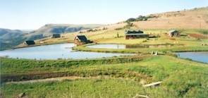
Dullstroom and Machadodorp have become popular trout-angling retreats and trout-farming activities in the area have increased dramatically. However, the trout industry also represents the greatest threat to river health in this region, for the following reasons. The construction of weirs and dams to contain the trout has resulted in a loss of wetlands, and modification of natural in-stream and riparian characteristics. Trout is not a native species, but it now occurs in most of the streams in this part. Trout is a predaceous fish, and has caused the indigenous chubbyhead barb (Barbus anoplus) to be lost from some streams, for example most of the Lunsklip River.
|
|
|
 |
Fish are not the only invasive biota in this area. Alien trees occur in the lower parts of this ecoregion, with wattles being the most common. This is a problem because they are replacing the natural vegetation, and use more water than indigenous trees, thereby reducing runoff, and impacting on the flow regimes in the river.
| |
|
The poor state of the Leeuwspruit can be attributed to a combination of agricultural activities (flow modification as result of water diversion and construction of several weirs, and modification of the riparian zone) and pollution from domestic origin (solid waste and effluent entering the stream in the Machadodorp vicinity). Alien species of fish, namely trout, largemouth bass and smallmouth bass have been sampled in the Leeuwspruit.
The Verlorenvallei Nature Reserve outside Dullstroom is an important conservation area,
perhaps best known as a home for the rare wattled crane, and has been proposed as a Ramsar site. The national Department of Environmental Affairs and Tourism is implementing a programme of wetland rehabilitation in this area. Such efforts to maintain ecological integrity by excluding human activity, form a vital component of an integrated landscape management plan.
|
|
Desired Ecological State and Response by Resource Managers
Rivers and streams in this ecoregion should be maintained in a
good
ecological state. This will not only ensure that the headwaters of this river system remain of high integrity, but will also ensure the sustainability of the trout industry.
To maintain a
good
ecological state it is essential that the trout industry develop in an environmentally responsible and sustainable manner. This includes not constructing trout dams in wetland areas or riffle areas, maintaining refuge areas, and controlling the release of trout so that impacts on indigenous species are minimised. A Strategic Environmental Assessment of the trout industry in this region is required to ensure optimal economic development and optimal environmental protection.
The riparian zone of rivers and streams must be protected against too much physical modification and encroachment by alien plants, and removal of alien vegetation from the riparian zone is a priority for management. A
fair
state is recommended as a realistic management goal for the Leeuwspruit, although some work and improved practises (especially related to domestic waste disposal and agricultural activities) will be required to achieve this goal.
|


|


