Ecoregion and River Characteristics
This ecoregion has greater variation in relief. The lower altitude (800 to 1 500 m) brings slightly warmer temperatures (16-18°C) and lower rainfall (600-800 mm per year). The dominant vegetation is grassland, on shallow lithosols overlying granites, quartzites and basalts.
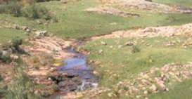
Here the Crocodile River is 10-15m wide, with rocky pools and runs with occasional riffles and some small waterfalls.
Present Ecological State
Good
for all the ecological indicators except
fair
for riparian habitats
Drivers of Ecological Change (Land-use activities)
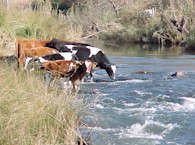
Agricultural activities (irrigated and dry-land cropping, cattle and sheep grazing) are widespread in this ecoregion. Conversion of natural habitat to cultivation results in loss of habitat, ecosystem processes, and in some cases loss of species. Application of agro-chemicals such as fertilisers and pesticides can also result in contamination or eutrophication of water bodies, altering their functioning and the water quality.