|
Ecoregion and River Characteristics
This area has moderate to high relief, being in the foothills of the escarpment (1 000 to 1 500 m amsl). Granite, quartzite, mudstone, sandstone and shales are the main geological types, which give rise to coarse, sandy shallow soils. This, together with moderate to high temperatures
(16-22°C) and relatively low mean annual precipitation (400-800 mm), supports a mixed bushveld vegetation type.
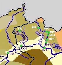
The Olifants River in this region is characterized by a single channel. After passing south of the foothills of the Strydpoort Mountains, the Olifants River converges with the Mohlapitse River. The source of the Mohlapitse River is in the Wolkberg Wilderness Area.
|
|
|
Present Ecological State
The ecological state of the Tongwane and upper Mohlapitse Rivers is
natural
. Habitat conditions in the lower parts of the Mohlapitse River are more impacted, being
fair
, with invertebrates, fish and riparian vegetation reflecting
natural
,
good
and
fair
health respectively. For both the Olifants and Steelpoort Rivers in this region, the biological indicators reflect a predominantly
poor
state with river habitats being in an
unacceptable
state.
|
|
|
Drivers of Ecological Change (Land-use activities)
Ecoregion 2.15
The Wolkberg Wilderness Area is a high priority conservation area, and river conditions within the reserve reflect this. The Mohlapitse River is a very good refuge for fish species, as it runs through part of the Wilderness Area, where stream conditions and habitat integrity are good.
|
|
Ecoregion 2.14
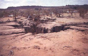
Outside the Wolkberg Wilderness Area, land and vegetation are generally highly degraded due to bad land practices and over utilization. In most parts riparian vegetation is completely absent. Small scale and subsistence crop cultivation are found in this region, as well as commercial banana plantations. Sections of the riverbank are seriously degraded due to clearing for planting of these crops, and for collection of fuel. The riparian vegetation is heavily grazed, and donga erosion is common in the riparian zone.
|
|
|
|
Desired Ecological State and Response by Resource Managers
The desired ecological state for the Tongwane River and the part of the Mohlapitse in ecoregion 2.15 is
natural
. These are high priority conservation areas. The Mohlapitse River further downstream is utilized more intensively, but also represents an important refuge area for many fish species and lies near a wilderness area. As such, the short-term desired state could be
good
, with a long-term aim of upgrading this section to a
natural
state. The Working for Water Programme has identified this as a priority area for clearing of Triffid Weed (Chromelaena ordata)
|


|
|


