RHP South African
River Health Programme
State of the Rivers Report
Crocodile, Sabie-Sand & Olifants
River Systems
go back to RHP homepage Table of Contents introduction/background overview of study area indicators and indices list of infoboxes with links
Ecoregion 2.14, 2.15 in the Olifants River System Crocodile River System Sabie-Sand River System Olifants River System summary Ecoregion 4.03 and 4.05 in Olifants River System

The Olifants River System

Ecoregion 2.11 & 2.12

Ecoregion and River Characteristics

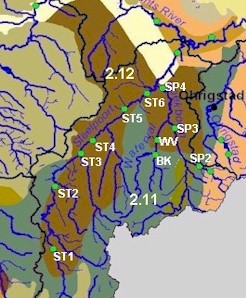
These ecoregions span the escarpment. Ecoregion 2.11 is situated on the Highveld Plateau and the upper slopes of the escarpment, and is characterized by highveld grasslands. Ecoregion 2.12 is on the lower slopes, and sees the conversion to mixed bushveld. Moderate to high relief and sandy shallow soils are found in both regions, as is moderate rainfall (600 to 1 000 mm per year). Temperatures however, show greater variation, ranging from 10-16°C on the upper slopes and
16-20°C on the lower slopes.

The Spekboom and Steelpoort Rivers, tributaries of the Olifants River, arise in these ecoregions. The Spekboom has its source in the mountains near Lydenburg. It joins the Waterval River and flows in a northerly direction to the confluence with the Steelpoort River, north-west of Burgersfort. From here, the Steelpoort River flows in a north-easterly direction and converges with the Olifants River in the Drakensberg near Kromellenboog.

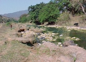
The river is steep, high lying, with riffles, rapids, and waterfalls in ecoregion 2.11. Wetlands and small gorges are also abundant. In 2.12 the river has a gentler slope, with predominantly sandy beds.

Ecoregion 2.11 & 2.12

Present Ecological State

Ecoregion 2.11
The Spekboom River is in a good state, with riparian vegetation slightly more impacted and reflecting fair health. The overall state of the Beetgekraal River is fair, with fish and invertebrates being good.

Ecoregion 2.12
The ecological state of the Steelpoort River is fair to unacceptable. The Spekboom River is generally in a good state. The habitats and riparian vegetation of the Waterval River are fair, while fish populations are good and invertebrates reflect a natural state of health.

Drivers of Ecological Change (Land-use activities)

Overgrazing, and dryland cultivation throughout the ecoregions, including in the riparian zone, leads to erosion, which causes high silt levels in the rivers. Smothering of in-stream habitats and fish gills results in loss of invertebrate and fish species. Siltation also increases the risk of flooding. Runoff from mines and other activities lowers the water quality in this ecoregion, and conditions are not likely to improve in the short term.

Desired Ecological State and Response by Resource Managers

Ecoregions 2.11 and 2.12
The desired ecological state for the Spekboom River is good , and for the Beetgekraal, Steelpoort and Waterval Rivers it is fair .

Back to RHP homepage back to table of contents back to top of page ecoregion 2.14 & 2.15 - Olifants River System ecoregion 4.03 & 4.05 - Olifants River System