Agricultural activities next to the Blyde River include commercial citrus irrigation. Runoff contaminated with agro-chemicals may result, as well as increased erosion and sedimentation due to clearing of land under the fruit trees.
Cocklebur (Xanthium strumarium), a declared weed, dominates the low-lying sandbanks, dry riverbeds and floodplains.
Ecotourism developments flourish around the potholes, in the Blyde River. This is positive in terms of tourism revenue, but the increased traffic and associated erosion must be managed to prevent an increase in sedimentation in-stream.
The stretch in the Lekgalameetsi Nature Reserve is in a natural condition, but the section downstream of the nature reserve is impacted due to water abstraction and weirs. Citrus farming occurs along the banks.
The Makhutswi River flows through a reserve area and the ecological status is good to natural. Trout farming in the Spekboom River has resulted in the loss of indigenous fish species. Many weirs impact the river flow and change the habitat. In spite of this, the water quality is very good. The Blyde River gorge has been cleared of alien species like wattles and pines, and water from the Blyde River generally improves the water quality in the Olifants River downstream of their confluence.
The Belvedere Creek flows through the Blyderivierspoort Nature Reserve. Rare fish species like the Rosefin Barb (Barbus argenteus) have been recorded in this ecoregion. The Belvedere Creek is the only place in the Limpopo system where this species is found.
The Treur River forms part of the Blyderivierspoort Nature Reserve, The Treur River Barb (Barbus treurensis) dissappreared from the Treur River in the 1960's. It was, however, rediscovered in the upper Blyde River during the 1970's. This section of the Blyde River was proclaimed a National Heritage Site i 1985. The Natal Mountain Catfish (Amphilius natalensis) also occurs in this part of the Blyde River (the only isolated population in the Limpopo system). The reintroduced Treur River Barb now flourishes in the upper reaches of the Blyde River. The Treur River is also one of the few places where dobsonflies are found (they usually occur in mountainous areas of the Western Cape, KwaZulu-Natal and Mpumalanga).
Alien vegetation occurs in the riparian zone of the upper reaches.
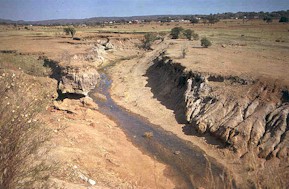
Trout are found in the Ohrigstad River. Flow regulation and abstraction, especially in the upper parts of the Ohrigstad River, cause the river to dry up in places during dry periods. Tobacco farms near Ohrigstad have an impact on river habitats. Water abstracted for agricultural purposes changes river flow downstream. The river is completely dry in areas. Flow regulation by Ohrigstad Dam during dry periods results in sedimentation and scouring of the riverbed. Alien vegetation is abundant along the Ohrigstad River.
Desired Ecological State and Response by Resource Managers
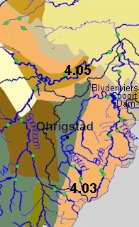
The desired state for the Makhutswi, Blyde and Treur Rivers, as well as for the Belvedere Creek, is
natural
. The Ga-Selati and Spekboom Rivers should be managed for a
good
state. A pragmatic management goal for the Origstad River is to achieve a
fair
state. However, the gorge-section that falls within the Blydepoort Nature Reserve should be managed for maintaining a
good
state. The Working for Water Programme has earmarked that area for alien clearing in 2001, particularly with respect to wattle, pine and eucalypts.
Flow regulations during dry periods should be improved.
Realistically, the Olifants and Steelpoort Rivers can only be maintained in a
poor
state, due to the nature and extent of activities in the catchment, which are likely to continue for a long time.