|
The Sabie-Sand River System
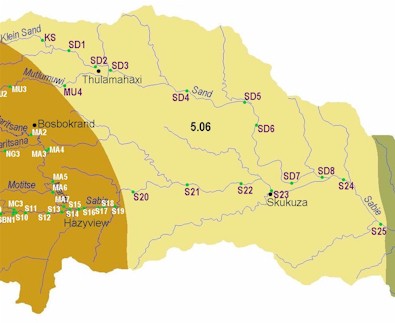
Ecoregion 5.06
|
|
Ecoregion and River Characteristics
Typical of the Lowveld, this ecoregion has an altitude range between 300 and 600 m amsl, plains with moderate relief. Mean annual precipitation (400-800 mm) is much lower than the higher ecoregions, and temperatures are higher with less variation (20-22°C).
| |
Sweet lowveld bushveld is the dominant vegetation type, supported by shallow black, brown, or red clayey soils, sandstones, granites and shales. Bilharzia may be present in some reaches of this ecoregion.
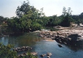
The Sabie and Sand Rivers converge in this region, in the Kruger National Park. River characteristics include a low gradient, some bedrock, pools and sandbars. Tall trees dominate the riparian zone, with reeds in open areas. The river is wide, with both a slow deep flowing channel and a broad chute over unfractured bedrock.
|
|
|
|
Present Ecological State
Due to the Kruger National Park and private conservation activities, much of this area is in a
natural
state. However, urbanisation and other land uses threaten the unprotected areas.
Sabie River: The in-stream components (habitats, fish and invertebrates) reflect a
natural
to
good
state, whereas the riparian components (habitats and vegetation) reflect a
good
to
fair
state.
Sand River: In this reach, parts of the riparian zone can be regarded as
natural
, whereas parts upstream of the Sabie Sand Game Reserve are
unacceptable
. The in-stream habitats and biota are generally
good
, and even approach
natural
in places.
|
|
|
Mutlumuvi River:
In-stream biota represents a
good
state, and habitats and riparian vegetation are
fair
.
Klein Sand River: This reach is predominantly
good
to
fair
, but a
poor
score was obtained with invertebrates. The riparian zone is one of the worst affected areas in terms of infestation by alien vegetation.
|
|
|
Drivers of Ecological Change (Land-use activities)
General: Land use in the upper part of this ecoregion is characterised by forestry. Some 20 000 ha of the upper catchment were cleared of alien plant species, which has resulted in recovery of winter flows in parts of the Sand River. The middle parts of the catchment experiences rural community activities such as subsistence and small scale farming of livestock and fruit. Overgrazing is a problem in this area, and where it occurs close to the riparian zone, has caused extensive erosion and sedimentation. The lower parts of the catchment are protected by conservation activities, in particular the Kruger National Park.
|
|
Sabie: Agricultural activities have an impact on the northern bank in some areas. The southern bank falls within the Kruger National Park. Although riparian vegetation and habitats here are largely natural, some alien vegetation does occur, and in some areas riparian vegetation has been cleared to provide tourists with clear views of the rivers and pools.
|
|
|
Sand: The central section of the catchment is densely populated. Overgrazing by livestock, including in riparian areas, is evident, and results in erosion of riverbanks and sedimentation
in-stream. The demand for water and the generation of wastewater are relatively high compared to less densely populated areas.
|
|
Desired Ecological State and Response by Resource Managers
The ecological state of the Sabie should be
good
in the upstream parts and should improve to
natural
downstream. The first part of the Sand, and the Mutlumuvi, can realistically only be managed for a
fair
state. The desired state for the Klein Sand and the lower half of the Sand River is
good.
|


|


