WaterMarque is a menu driven set of tools developed using GIS technology for the assessment, query, display and reporting of water quality information. It is based on water quality data collected throughout the country together with a range of geographical data sets for available background information.
WaterMarque consists of a set of menus that will allow users trained in water quality evaluation to access water quality and associated information, analyse that information and produce output maps.
WaterMarque was developed as a collaborative project between the following agencies: Institute for Water Quality Studies of the Department of Water and Sanitation, the CSIR Division of Water, Environment and Forestry Technology (Environmentek), Stewart Scott Incorporated, GisLAB (formerly of the University of Pretoria), and GIMS (Pty) Ltd. of Midrand.
The system was prototyped by the Institute for Water Quality Studies and stabilised by GIMS under contract to the Institute. Installation and a hotline support service are provided by GIMS.
WaterMarque uses various datasets obtained from the following agencies: Department of Water and Sanitation, National Botanical Institute, the Chief Director of Surveys and Land Information, the CSIR, the Water Research Commission and the University of Natal. A more detailed description of the datasets, copyright notices and usage limitations with respect to the system data dictionary are in the appendix.
The WaterMarque main screen has a number of elements that are visible throughout the session.
The main elements, some of which are shown above, are:
Locational inset map
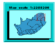
In the lower right-hand corner of the main screen is the locational inset map. This map indicates the extent that the map being drawn on the main screen occupies relative to the whole of South Africa. This is particularly useful as you zoom in or pan across catchments.
The extent of the large main map is indicated on the locational map of South Africa by a red hatched box.
![]()
Panzoom menu
The Panzoom menu provides access to generic facilities for changing the extent of the area displayed on the main map.
The facilities include :
Main menu bar
The Main menu bar is always located at the left of the screen.
The menu icons or buttons are as follows :
Other onscreen features
In addition to the primary features which are to be found on screen there are a number of smaller features. These smaller features are building blocks of the larger features.
![]() You do not always have to
press <Enter> on the keyboard to ensure that the
information entered in that field is accepted by WaterMarque. It
is only required on this first menu in WaterMarque.
You do not always have to
press <Enter> on the keyboard to ensure that the
information entered in that field is accepted by WaterMarque. It
is only required on this first menu in WaterMarque.
 For example, a popup menu
allowing you to select a colour has a scrollbar on the right
which allows you scroll through and select the colour that you
want. Place the cursor arrow on the downward facing arrow and
depress the left mouse button. The scrollbar elevator will slowly
descend, exposing colours within the box as it does so.
For example, a popup menu
allowing you to select a colour has a scrollbar on the right
which allows you scroll through and select the colour that you
want. Place the cursor arrow on the downward facing arrow and
depress the left mouse button. The scrollbar elevator will slowly
descend, exposing colours within the box as it does so.Within WaterMarque all menus can be accessed simultaneously, allowing you to cross-reference sections and choices within one session. The menu structure is not hierarchical, in which you become increasingly isolated in one specialised field of inquiry. This freedom to enter various functions, in any order, must be used carefully lest you miss selecting vital data or coverages and have to start again. For example, the dataset must be selected or recalled from memory before a time series data query can be processed.
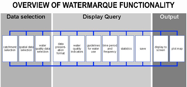
Major WaterMarque Modules
WaterMarque is best understood in terms of functionality modules, where sets of similar functions are grouped together.
These modules are accessed in the Main menu bar, and constitute the primary interface procedure.
In WaterMarque there are five main functionality modules.
Each of these modules consists of a number of menus which are constructed similarly as they perform similar but different functions. (e.g. the layers module menus).
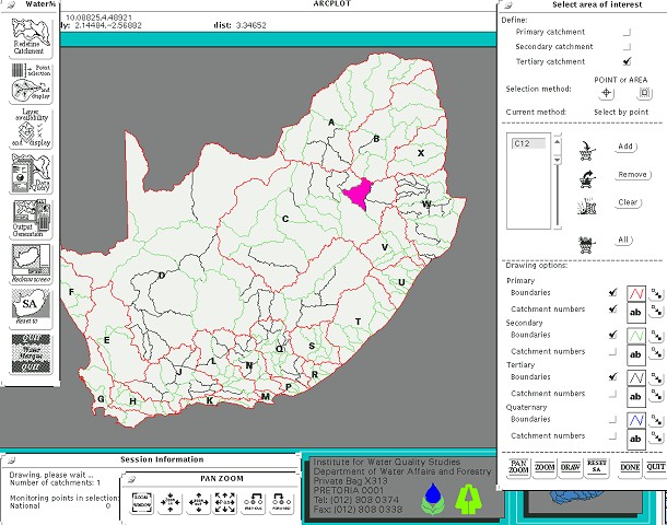
This module allows you to select an area of interest on the basis of prenamed and determined catchments. The catchments are defined at primary, secondary and tertiary catchment levels. You can display quaternary catchment boundaries, but cannot use them for selection.
This module presents a range of geographic features which are vital background information for the process of water quality assessment. The features have been grouped according to natural environmental features (elevation, geology, vegetation) and man-made environmental features (infrastructure, towns, landuse). The features are displayed as shaded areas (polygons), linear or point symbols. A number of different features may be simultaneously selected and displayed.
This module allows you to inspect the data from the different water quality monitoring networks recognised by the DWAF.
Monitoring points can be interrogated in three ways:
The module extends further in allowing you to initiate a query session on the record of data collected at the monitoring points you selected.
This module allows you to select the water quality variables of interest, the recommended guidelines for use and the time period of data to be assessed. A number of graphs and symbols are available for display of the data, including standard time series graphs, box and whisker plots, pie charts and some non-standard symbols specially adapted for WaterMarque e.g. radial time series and maucha diagrams.
The Data Query Module module also allows you to recall previously saved data and dispense with the tedious process of monitoring point reselection.
The Output module allows the selections you made within the session to be converted into a graphics file format, from which you will be able to plot. The paper size can be selected, as well as various map features. It is important to note that this version of WaterMarque only allows you to print in landscape orientation.
Switches off current catchment selection and resets map display to show the full extent of South Africa.
Several submodules within WaterMarque are very useful for manipulating various aspects of data representation. These will be discussed in more detail within the module chapters.
Each functionality module is a system which can be accessed on its own or in conjunction with other modules. Each module performs a selected function, within the analysis of water quality data, usually not performed by the other modules. However, the Point Selection and the Data Query module do share, for convenience, some of the same functions. These will be discussed in greater detail later.
Conventions Specific to WaterMarque
Menus in WaterMarque share various conventions and similarities. Certain symbols and icons occur repeatedly in menus of many different functions.
Quit icon
Common to all menus in WaterMarque is the Quit icon. The purpose of the Quit icon is to allow you to exit a menu or module quickly without having to enter information into a field and to avoid having to make selections.
For example, you have mistakenly entered into the Administrative Boundaries menu when you really wanted to be in the International Boundaries menu. Without having to select unwanted data from the datasets in the Administrative Boundaries menu, you can simply click on the Quiticon found at the bottom of all menus. The exceptions are those menus that form the backbone of the system's functionality, such as the session information, the Main menu bar and the Pan Zoom menu.
Draw icon
The Draw icon is found on almost all menus and serves the purpose of allowing you to draw your selections from various selections to screen.
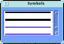
Change Symbols Icon
The Change Symbols icon occurs on menus which provide you with the ability to display data to the screen and maps as layers of colour or symbols representing certain values or occurrences, e.g. waterweed symbol. These symbols are set up within WaterMarque as defaults. These can be reset by simply clicking on Reset icons on selected menus.
The Change Symbols icon allows you to change a symbol for a value or occurrence on the map with a choice from a predetermined characterset. To see how it works click on the Change Symbols icon.