Chemical monitoring programme  Eutrophication monitoring programme  Microbial monitoring programme  Ecosystem monitoring programmes  Monitoring sites in Google Earth   SA Flag
RQS home
WMS logo
Inventory home
Sites:
Select from table:
primary drainage region
water management area
Select from map:
primary drainage region
water management area
'Top 333' NCMP sites:
all drainage regions
old version
Hydrological sites:
rivers
dams
estuaries
climate
"local"
Information:
Help & tutorial
About the system
Rivers and catchments in Google Earth format
Scripts used to generate this site

Water quality monitoring sites grouped by 19 water management areas
(excluding borehole data)

Google Earth logo

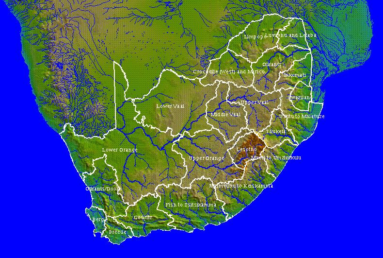
Please click on a drainage region to view the sites in Google Earth, if it is installed on your computer.

Depending on the configuration of Google Earth on your computer, you may need to save the KMZ file before it will open. You will need to adjust the pointers on the Google Earth time slider in order to see all sites.
If you do not have Google Earth, please choose a "Select from table" option from the left menu.

Note that boreholes are excluded from this selection in order to reduce download times.

To see all borehole sites, choose a "Select from table" option from the left menu.

The most common problem is the time slider spanning the wrong dates.

Water Management Areas Limpopo Luvuvhu_and_Letaba Olifants Crocodile_West_and_Marico Inkomati Lower_Orange Lower_Vaal No region Middle_Vaal Upper_Vaal Usutu_to_Mhlatuze Thukela Upper_Orange No region Mvoti_to_Umzimkulu Olifants-Doorn Mzimvubu_to_Keiskamma Fish_to_Tsitsikamma Gouritz Berg Breede No region

Please report problems with this viewer and make suggestions for improvements to: Michael Silberbauer.


Last update of this page 2014-06-02 14:32
This site should work on most browsers. Please send comments to the webmaster