Untitled Page
DWS Home Page  
 

HYDROGEOLOGICAL MAP SERIES

right menu


bullet
Mapping Project Status
   
bullet
Maps and brochures are obtainable for R50.00 each (VAT, postage and packing included) from:
  Directorate: National Hydrological Services
Bag X313
Pretoria
0001
E-mail:
georequests@dws.gov.za
or
Department Map Shop
Tel: +27 12 336 7249
E-mail:
rbm@dws.gov.za
 
Untitled Page

Groundwater Home

Groundwater Offices

Data Management


Documents

Forms

Groundwater Dictionary

Contacts

Links

FAQs


click for larger

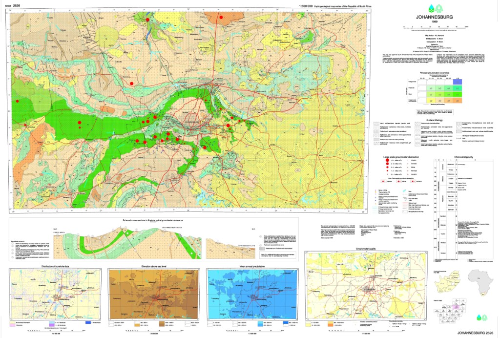
The single A0 map sheet comprises:

  • Main map
    • depicting groundwater occurrence (aquifer type and borehole yields) superimposed on a lithological background (scale 1 : 500 000) (view hydrogeological maps)

  • Inset maps
    • distribution of borehole data (scale 1 : 2 000 000)
    • elevation above sea level (scale 1 : 2 000 000)
    • mean annual precipitation (scale 1 : 2 000 000)
    • groundwater quality (scale 1 : 1 500 000)

  • Conceptual cross section
    • a schematic illustration of typical modes of groundwater occurrence (not to scale)

Please note: The map depicts groundwater conditions on a regional scale and cannot be used for borehole siting or any other site-specific investigations or deductions.


Untitled Document
This site is best viewed with Internet Explorer 10 (or newer) and Mozilla Firefox 32.0 (or newer) at 1024x768 screen resolution.Click here to download Internet Explorer 11 or click here to download Firefox 32.
DWS Sitemap
If you experience any challenges regarding this site, please contact the Webmaster .